EP1840522B1 - Appareil de navigation et procédé destinés au fonctionnement d'un appareil de navigation - Google Patents
Appareil de navigation et procédé destinés au fonctionnement d'un appareil de navigation Download PDFInfo
- Publication number
- EP1840522B1 EP1840522B1 EP20070005904 EP07005904A EP1840522B1 EP 1840522 B1 EP1840522 B1 EP 1840522B1 EP 20070005904 EP20070005904 EP 20070005904 EP 07005904 A EP07005904 A EP 07005904A EP 1840522 B1 EP1840522 B1 EP 1840522B1
- Authority
- EP
- European Patent Office
- Prior art keywords
- body part
- navigation information
- presentation
- determined
- basis
- Prior art date
- Legal status (The legal status is an assumption and is not a legal conclusion. Google has not performed a legal analysis and makes no representation as to the accuracy of the status listed.)
- Not-in-force
Links
Images




Classifications
-
- G—PHYSICS
- G01—MEASURING; TESTING
- G01C—MEASURING DISTANCES, LEVELS OR BEARINGS; SURVEYING; NAVIGATION; GYROSCOPIC INSTRUMENTS; PHOTOGRAMMETRY OR VIDEOGRAMMETRY
- G01C21/00—Navigation; Navigational instruments not provided for in groups G01C1/00 - G01C19/00
- G01C21/26—Navigation; Navigational instruments not provided for in groups G01C1/00 - G01C19/00 specially adapted for navigation in a road network
- G01C21/34—Route searching; Route guidance
- G01C21/36—Input/output arrangements for on-board computers
- G01C21/3664—Details of the user input interface, e.g. buttons, knobs or sliders, including those provided on a touch screen; remote controllers; input using gestures
-
- G—PHYSICS
- G01—MEASURING; TESTING
- G01C—MEASURING DISTANCES, LEVELS OR BEARINGS; SURVEYING; NAVIGATION; GYROSCOPIC INSTRUMENTS; PHOTOGRAMMETRY OR VIDEOGRAMMETRY
- G01C21/00—Navigation; Navigational instruments not provided for in groups G01C1/00 - G01C19/00
- G01C21/26—Navigation; Navigational instruments not provided for in groups G01C1/00 - G01C19/00 specially adapted for navigation in a road network
- G01C21/34—Route searching; Route guidance
- G01C21/36—Input/output arrangements for on-board computers
- G01C21/3626—Details of the output of route guidance instructions
- G01C21/3635—Guidance using 3D or perspective road maps
-
- G—PHYSICS
- G01—MEASURING; TESTING
- G01C—MEASURING DISTANCES, LEVELS OR BEARINGS; SURVEYING; NAVIGATION; GYROSCOPIC INSTRUMENTS; PHOTOGRAMMETRY OR VIDEOGRAMMETRY
- G01C21/00—Navigation; Navigational instruments not provided for in groups G01C1/00 - G01C19/00
- G01C21/26—Navigation; Navigational instruments not provided for in groups G01C1/00 - G01C19/00 specially adapted for navigation in a road network
- G01C21/34—Route searching; Route guidance
- G01C21/36—Input/output arrangements for on-board computers
- G01C21/3667—Display of a road map
-
- G—PHYSICS
- G01—MEASURING; TESTING
- G01C—MEASURING DISTANCES, LEVELS OR BEARINGS; SURVEYING; NAVIGATION; GYROSCOPIC INSTRUMENTS; PHOTOGRAMMETRY OR VIDEOGRAMMETRY
- G01C21/00—Navigation; Navigational instruments not provided for in groups G01C1/00 - G01C19/00
- G01C21/26—Navigation; Navigational instruments not provided for in groups G01C1/00 - G01C19/00 specially adapted for navigation in a road network
- G01C21/34—Route searching; Route guidance
- G01C21/36—Input/output arrangements for on-board computers
- G01C21/3679—Retrieval, searching and output of POI information, e.g. hotels, restaurants, shops, filling stations, parking facilities
- G01C21/3682—Retrieval, searching and output of POI information, e.g. hotels, restaurants, shops, filling stations, parking facilities output of POI information on a road map
-
- G—PHYSICS
- G01—MEASURING; TESTING
- G01C—MEASURING DISTANCES, LEVELS OR BEARINGS; SURVEYING; NAVIGATION; GYROSCOPIC INSTRUMENTS; PHOTOGRAMMETRY OR VIDEOGRAMMETRY
- G01C21/00—Navigation; Navigational instruments not provided for in groups G01C1/00 - G01C19/00
- G01C21/26—Navigation; Navigational instruments not provided for in groups G01C1/00 - G01C19/00 specially adapted for navigation in a road network
- G01C21/34—Route searching; Route guidance
- G01C21/36—Input/output arrangements for on-board computers
- G01C21/3691—Retrieval, searching and output of information related to real-time traffic, weather, or environmental conditions
- G01C21/3694—Output thereof on a road map
-
- G—PHYSICS
- G06—COMPUTING OR CALCULATING; COUNTING
- G06F—ELECTRIC DIGITAL DATA PROCESSING
- G06F3/00—Input arrangements for transferring data to be processed into a form capable of being handled by the computer; Output arrangements for transferring data from processing unit to output unit, e.g. interface arrangements
- G06F3/01—Input arrangements or combined input and output arrangements for interaction between user and computer
- G06F3/017—Gesture based interaction, e.g. based on a set of recognized hand gestures
-
- G—PHYSICS
- G06—COMPUTING OR CALCULATING; COUNTING
- G06F—ELECTRIC DIGITAL DATA PROCESSING
- G06F3/00—Input arrangements for transferring data to be processed into a form capable of being handled by the computer; Output arrangements for transferring data from processing unit to output unit, e.g. interface arrangements
- G06F3/01—Input arrangements or combined input and output arrangements for interaction between user and computer
- G06F3/048—Interaction techniques based on graphical user interfaces [GUI]
- G06F3/0481—Interaction techniques based on graphical user interfaces [GUI] based on specific properties of the displayed interaction object or a metaphor-based environment, e.g. interaction with desktop elements like windows or icons, or assisted by a cursor's changing behaviour or appearance
-
- G—PHYSICS
- G06—COMPUTING OR CALCULATING; COUNTING
- G06F—ELECTRIC DIGITAL DATA PROCESSING
- G06F2203/00—Indexing scheme relating to G06F3/00 - G06F3/048
- G06F2203/048—Indexing scheme relating to G06F3/048
- G06F2203/04806—Zoom, i.e. interaction techniques or interactors for controlling the zooming operation
Definitions
- the invention relates to a navigation device and a method for operating a navigation device.
- Navigation devices are already used in many vehicles today. They provide guidance to a vehicle operator in locating and locating a desired route to travel from one exit point to one or more destination locations. In this case, navigation devices output hint information. These are usually displayed on a display device and / or in the form of acoustic signals, such as spoken messages issued. For this purpose, an environment map of the vehicle, the starting location or a desired destination is usually displayed on the display device.
- a destination is usually entered or recorded in the modern navigation devices via multifunction control devices.
- several operating options or Amsterdambeh are usually displayed on the display device.
- one of the input options is selected.
- the display device is integrated in a multi-function operating device, which is designed as a touchscreen unit, a selection can be made by touching the display device at the point at which the input option is shown graphically.
- Other embodiments provide that one of the input options is provided with a focus, which can be assigned to the different input options, for example via an operating element designed as a rotary knob. By pressing a further control element or by an axial movement of the rotary knob, if this is designed as a rotary push button, then the Amsterdambebaukeit be selected, to which the focus is just assigned.
- This input is usually done in stages in the way that initially only the first letter of the place is selected, which should be entered or recorded. Subsequently, the second letter or the combination of the first already selected letter and a second letter is detected or selected. This process will be continued gradually. If the possible input options can be reduced to a manageable number, a final list is displayed from which an input option is selected or recorded.
- This method in its various embodiments, has proved reliable but is time consuming and unintuitive due to its multistage nature.
- some special knowledge of the driver is required. For example, to enter the airport of a city as a navigation destination, it is in some embodiments, it is necessary to know the place name within the boundaries of which the airport is located. These are often small unknown locations at big city airports.
- a displayed map in which a crosshair or a so-called cursor are moved.
- This process also usually has to be executed in several stages in order to achieve the necessary resolution for a target point input.
- First, an overview map is displayed. The cursor is moved to a destination area or to a tentative destination location. This can be done for example by means of arrow keys designed controls.
- an environment around the target position is enlarged.
- the map section shown is smaller and at the same time its position resolution is increased. If the position resolution is sufficient, the destination can be finalized.
- the enlargement of the detail takes place stepwise in preset magnification levels.
- This type of target point input / detection is particularly suitable for the navigation device already known destination points, sights and functional facilities such as airports, etc., which can be displayed in a map display by means of a graphical symbol or a characteristic image.
- Modern navigation devices offer a variety of additional services.
- hotels, restaurants, cinemas, attractions, petrol stations, towns, etc. can be searched and displayed via the navigation device in an environment from a predetermined location .
- the individual POIs displayed can be used to display or output additional information (opening times, a menu, a program, etc.).
- the POI are displayed in a predefined radius.
- the vehicle is arranged centrally in the map display.
- Orientation is often difficult on these map sections, since the section is based on preset magnification levels of the navigation map.
- the section is based on preset magnification levels of the navigation map.
- an information display device with a touch screen is known on the map sections are displayed.
- the device is designed so that it is possible to switch between different display states upon touching a predetermined range. In one state, a map section and a window with an enlarged map section are displayed. In another state, only one map section is displayed.
- WO 02/16875 A1 For example, there is described a method of retrieving a destination information in which a three-dimensional object in a map view can be selected. So that a user can move virtually in the map view, gestures of the user are evaluated.
- the US 2006/0026521 A1 describes a method and a system for processing touch inputs, which are detected in particular with a multi-point touch-sensitive operating element, for example a touchscreen, which can detect several touches at the same time.
- the invention is therefore based on the problem to provide a navigation device and a method for operating navigation devices, which allow a simpler and more intuitive operation of the navigation device, in particular a selection of map sections and target positions or points of interest.
- a navigation device with a display device and at least one sensor unit for determining a position of a body part, in particular a finger, a user at least relative to a display surface of the display device is proposed, wherein a display of navigation information, in particular of map sections, depending on the determined position of the body part adapted to the display area. This allows an intuitive and easy operation of the navigation device.
- a wide variety of customization options can be easily controlled and operated on the body part by dividing a volume in front of the display area into sub-volumes, and the sensor unit is configured such that determining the position includes determining one of the sub-volumes in which the body part is located, comprises and an adaptation of the representation of the navigation information in dependence on the determined partial volume is carried out, in which the body part is located.
- the subvolumes can be assigned different adaptation functions.
- the volume in front of the display area may be subdivided into layers that run parallel to the display area. For example, zooming in on one layer, zooming out on another layer, and so on. Another layer may be subdivided into four sectors, with each sector being associated with a slice shift in one direction.
- the division can also be done in more or less sectors than four sectors. Furthermore, the adjustment may additionally depend on the exact position of the body part within the sub-volume. In the described exemplary embodiment, each of the four sectors may be associated with the slice shift in a predetermined direction. With what "speed" the clipping shift or with how large shift steps the clipping shift takes place may depend on the exact position of the body part, eg finger, within the sector.
- the volume in front of the display area is considered to be the subspace in front of the level in which the display area is located. This means that the volume in a direction of extension parallel to the display surface can have a substantially greater extent than the display surface itself.
- the size of the volume is practically determined by a sensor range within which the at least one sensor unit at least partially, that is, the position of the body part. determine at least one position in the space specifying.
- the sensor unit is configured, at least one gesture, for example based on a surface extension (static gesture) or an executed movement (dynamic gesture), and an adaptation of the representation in time after the recognition of the at least one gesture as a function of the position and / or the determined at least one further position and / or the determined speed and / or the determined sub-volume takes place in a modified manner, in particular in such a way that no adjustment takes place.
- at least one gesture for example based on a surface extension (static gesture) or an executed movement (dynamic gesture)
- an adaptation of the representation in time after the recognition of the at least one gesture as a function of the position and / or the determined at least one further position and / or the determined speed and / or the determined sub-volume takes place in a modified manner, in particular in such a way that no adjustment takes place.
- a navigation device advantageously comprises an adaptation unit, by means of which the adaptation of the representation takes place.
- the adaptation unit can be integrated in a central computer unit of the navigation device.
- it comprises a component embodied in software, by means of which the position determined by the sensor unit is processed in order to adapt the presentation of the navigation information, in particular of map information, accordingly.
- the sensor unit is configured so that the determination of the position comprises at least determining a distance of the body part of the display surface and the representation of the navigation information with respect to an enlarged detail of the navigation information, in particular a detail size of the map section dependent adjusted by the determined distance. This makes it possible, for example, coupled with a movement of the body part on the display surface to zoom in on a map (or out) and zoom in on a movement away from the display surface out of the map (or into).
- an embodiment of the invention provides that the sensor unit is configured such that the determination of the position is at least the Determining a lateral distance of the body part of a standing on the display surface central axis comprises and the representation of the navigation information is adjusted with respect to a selection of the selection of the navigation information, in particular a clipping region selection of the map section, depending on the determined lateral distance.
- a virtual axis is considered which extends from the display surface into a volume in front of the display surface.
- the point of view of the central axis in the imaging surface will lie in a center of the display area.
- a minimum angle of inclination of the central axis, Measured against a tangential surface of the display area in the Auf Vietnamese, depending on the arrangement of the display area is set relative to the position of a user. In one embodiment, this angle is 90 °. In a motor vehicle, however, in which the display surface of the navigation device is mounted in a center console, an angle smaller than 90 ° can also be advantageous.
- the central axis is then preferably arranged so that it points from the point of view in the direction of a user, usually the driver, who wants to operate the navigation device.
- the central axis is aligned along a preferred direction of movement in which the user moves his finger to a center on the display surface when he wants to touch it.
- a preferred direction of movement in which the user moves his finger to a center on the display surface when he wants to touch it.
- the adaptation of the representation as a function of the distance and / or the lateral distance can be carried out continuously and / or stepwise.
- a location-dependent, preferably touch-sensitive actuating element for example in a display device designed as a touchscreen, at any point on the display surface without triggering an adaptation of the representation of the navigation information immediately prior to actuation
- at least a partial volume is excellent, within which a movement of the body part is possible, without causing an adaptation of the representation of the navigation information.
- This partial volume is preferably arranged directly adjacent to the actuating element.
- the sub-volumes partially overlap one another. This makes it possible to design a change of the adaptation function hysteresis. This means that the body part is considered to be located in an adjacent subvolume only if it is not at the same time still in the subvolume in which it was previously located. This means that only when the body part has left the overlapping area is it considered to be in the other partial volume.
- the sensor unit is designed to determine at least one further position in advance in time, and the adjustment in the representation takes place as a function of the at least one further position and the position. This makes it possible for certain sub-volumes to be assigned an adaptation function only if another adaptation function has previously been triggered, ie. H. the body part was in the further position.
- a triggering of the adaptation can be time-dependent. This means that adaptation takes place depending on the position and a dwell time at the position or in an environment thereof. Likewise, an actuation of a function that is associated with displayed navigation information, depending on the residence time and thus done without contact. An operating element encompassed by the navigation information can thus be actuated without contact.
- a destination may also be entered by holding the body part for a predetermined amount of time in a position or area about the position that is spatially adjacent to the representation of the destination on the display area. The destination is then the location detected, which is shown under the body part as navigation information. "Under" in this context means that the position is projected onto the display surface.
- the projection direction is determined by a viewing direction of the user on the display surface, which runs through the position at which the body part is located.
- this navigation information can be superimposed on the display with a marking, for example a point or a crosshair.
- a preferred embodiment of the invention comprises a speed determination unit for determining a speed of the body part, whereby an adaptation of the representation of the navigation information additionally takes place as a function of the ascertained speed.
- the speed at which the body part is moved into position in addition to the position affect the adjustment. If, for example, the body part is moved toward or away from the display surface at a speed above a first threshold speed, an adjustment of the display may be omitted, for example.
- the position is adapted to the representation, which corresponds for example to a detail enlargement, which is associated with the corresponding distance corresponding to the position.
- a preferred embodiment includes a calibration module that executes a calibration routine in which the user performs predetermined motions upon instruction of the navigation system to make a custom fit.
- the data obtained here and / or configuration data derived therefrom can be stored in a memory device. These can be or are linked to a user identifier which is correlated, for example, with a vehicle key or is detected by the navigation device using a standard configuration by the navigation device itself. For example, it is provided that when commissioning as navigation information, a list of known users is displayed and depending on the determined position of the body part of the user, in which he has moved the body part, its corresponding user ID is selected.
- Fig. 1 is a schematic representation of a display device 1 of a navigation device shown. Shown is a map section 2 in an overview.
- a user moves his finger 3 (cf. Fig. 2 ) to the display device.
- a position of the finger 3 is detected.
- the enlargement scale of the illustrated map section 2 is determined and the map section 2 is displayed enlarged correspondingly, as in FIG Fig. 2 is shown.
- the navigation device is preferably designed so that the enlargement of the detail is proportional to the distance of the finger from the surface of the display device. This means that a large area is displayed on a small scale on the display device when the finger is at a large distance and a small area is enlarged (zoomed in) is displayed when the finger is in a small distance in front of the display device.
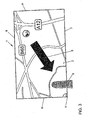
- the area is displaced when the finger is removed from a central axis.
- the central axis preferably coincides with a viewing axis from the user to a center of the display device. This means that, from the user's point of view, the finger is moved to the edge or even beyond it to "move" the map. This is in Fig. 3 indicated.
- the finger 3 is moved to a lower left corner 4 of the display device.
- the map section shown will be adjusted accordingly. That is, in the Overview map, the map section also moves to the bottom left relative to the in Fig. 2 illustrated map detail. This is indicated schematically by means of an arrow 5. At a left edge 6 and a bottom edge 7 "new" map information appears, while at an upper edge 8 and a right edge 9 map information "disappears".
- the shift in the map plane and the selection of the magnification can occur at the same time, so that the zooming and shifting takes place depending on the spatial position of the finger.
- This volume can be chosen to be cylindrical or a volume resulting from a projection of a display area of the display device along the central axis. Other shapes can be chosen for the volume.
- the central axis in one embodiment is perpendicular to a center of a display area of the display device. The choice of a central axis, which deviates from this orientation, offers the possibility to perform the operation adapted to a line of sight of the driver.
- the central axis is chosen, for example, congruent to a viewing direction of the vehicle driver on the center of the display panel of the display device.
- a determination of the central axis can be made by means of a calibration method in which the user is requested to guide the body part used for actuation to the center of the display area.
- the curve following the body part can be detected and used as the central axis. This means that the central axis does not necessarily have to be approximated by a straight line, but can also be a curved continuous curve.
- the sensor or sensors are preferably designed such that a spatial extent of the body part can be detected. This creates the opportunity to interpret gestures.
- a gesture is carried out by hand which is recognized as an operating stop signal. If, for example, the remaining fingers of the hand are unfolded, resulting in a flat hand, the surface of which is oriented essentially perpendicular to the central axis, this is recognized as an operating stop signal. The hand can now be removed in front of the display device of the navigation device, without this having an influence on the presentation.
- the zooming and shifting of the map section can also be advantageously achieved in other ways.
- the space or the volume before and optionally also in addition to the display device in sub-volumes which are also as three-dimensional sections, layers or areas or sectors, preferably cuboid or cylindrical / or cone sector sections divided.
- the partial volumes are assigned actions. If a fingertip is in a subvolume or section, the corresponding action will be performed.
- the sub-volumes or sections may overlap in space to achieve hysteresis-like operation. This causes a fingertip, which has moved from one section to another section, to be clearly moved back out of that other section into the one section only to be considered to be in the one section again. A continuous unwanted change between two actions is thereby avoided.
- the space area 10 in front of the display device 11 is subdivided into five sub-volumes or zones 12-16, which are arranged in parallel in front of the display panel of the display device.
- the innermost zone 12 (adjacent to the display field) is assigned no action or the function "leave display unchanged".
- the next zone 13 is assigned a function Move map section.
- the zone is subdivided into a plurality of sectors 13a, 13b, 13c, 13d, to which the sub-actions are shifted downward 13a, left 13b, top 13c, right 13d.
- An overlying zone 14 is assigned the zoom in action and a fourth zone 15 is again associated with the leave empty action.
- a fifth and outermost zone 16 is assigned the action Zoom Out.
- the associated action is executed.
- the zooming takes place as long as the finger is in the corresponding zones 14 or 16.
- the action associated with zones 12-16 will be performed only at a certain predetermined residence time of the finger in zone 12-16.
- the assigned function / action of a zone 12-16 depends on which zone 12-16 the finger is moved into the respective zone 12-16 or with which speed it moves into the zone.
- a zoom out of the representation does not occur. This only takes place if an enlargement of the representation has previously taken place in the same operating context.
- the innermost zone 12 is assigned no action (or the action "leave the display unchanged") to allow an operator action to be performed on a display device 11 embodied as a touch screen without changing the representation of the map section. This makes it possible to select each point on the map shown.
- a central axis 17 in this embodiment is perpendicular to a surface of the display device.
- the division of the volume into sub-volumes, into areas and zones and sectors, can be adapted to the respective requirements. More or less than five zones can be used.
- the zones can be divided into any number of subzones or sectors.
- the position can also be used for the variable change. Ie. in a zone or section, the position of the finger within the zone may affect or set the zoom speed (magnification per unit of time). The position within the zone can also indicate the magnification level.
- One embodiment provides that a selection of operating elements which are integrated in the map display takes place when the finger lingers over a predetermined operating time span over the operating element.
- Fig. 5 Such a situation is shown in which additional information is linked to a location, here the city of Mainz, in a map display. This additional information is an acoustic information and already selected, as indicated by a progress bar 20, which symbolizes a playback of the acoustic information about the city of Mainz. Two-thirds of the acoustic information has already been issued.
- information 21 associated therewith is preferably displayed enlarged. This is in Fig. 6 indicated.
- Fig. 7 is a point of interest 22 enlarged.
- Embodiments may be formed that include individual ones of the described features or different combinations of the features.
- FIG Fig. 8 an embodiment of a navigation device will be described, which is shown schematically in FIG Fig. 8 is shown and in which an operating method is implemented, which supports the above-explained operations.
- a navigation device 30 comprises a map memory 31, a device 32 for determining the position of the vehicle, preferably a satellite navigation receiver, a control unit 33, a display device 34 and a device 35 for detecting user inputs.
- the navigation device 30 is integrated in a multi-function operating device 36.
- the device 35 for detecting user inputs comprises one or more sensor units 37, which can or can detect a position of a body part, for example a finger, of a user in front of the display device 34.
- the device 35 comprises at least four sensor units 37 arranged at the corners of the display device, which can detect high-frequency signals transmitted via the user's body.
- Such sensor units 37 can be designed so that they already detect an approximation of the body part.
- camera-based, ultrasound-based, or optical sensor-based sensor units may be used.
- Such a sensor unit using an optical method may be configured, for example, according to the following principle.
- a transmission LED emits a rectangular amplitude modulated light signal in the optical or infrared wavelength range.
- the light signal reflected on an object, for example the body part is detected by a photodiode.
- a compensation LED a 180 ° out of phase, also rectangular amplitude modulated reference light signal is sent to the photodiode via a fixed light path.
- the compensation LED is adjusted via a control loop by means of a control signal so that cancel the received reflected light signal of the transmit LED and the received reference light signal of the compensation LED on the photodiode and a DC signal is detected.
- a change of the Control signal is a measure of the distance of the object.
- a configured according to this principle sensor unit is largely independent of temperature and brightness variations.
- the navigation device may comprise any further operating elements 38.
- a map section is usually displayed on the display device 34, the center of which coincides with a current position of the vehicle.
- a position of a finger of the user is detected by the sensor unit (s) 37.
- the representation of the map excerpt is adjusted by means of the control unit 33, which comprises a customization unit 39 often executed in software, on the basis of the navigation information stored in the map memory 31. If the resolution of the representation is sufficient to accurately input the target position, the user touches the display device 34, which is designed as a touch screen device. In order to leave an adaptation of the map representation unchanged, the user spreads his fingers apart, for example.
- the sensor units 37 detect a larger areal extent of the body part, since a minimum distance to the different sensor units 37 is reduced in each case. From this, the control unit 33 recognizes an operating stop gesture and leaves the map display unchanged, for example, for a predetermined period of time. Drawing a circle with a finger can also be a possible operation stop gesture. While the first gesture is static, the second proposed operator pacing gesture is dynamic and depends on the determination of the position of the body part at successive times, and optionally additionally on a speed at which the individual positions on the circle are traversed by the body part. The control unit 33 detects the position on the display device 34 and calculates the associated card position. This is used as the target location for targeted map-based navigation, as is known in the art.
- the display device can be designed as a projection display, in which the displayed information is projected onto a surface. In such a case, the distance or movement of the body part, etc. relative to this surface is relevant.
Landscapes
- Engineering & Computer Science (AREA)
- Radar, Positioning & Navigation (AREA)
- Remote Sensing (AREA)
- Physics & Mathematics (AREA)
- General Physics & Mathematics (AREA)
- Automation & Control Theory (AREA)
- Theoretical Computer Science (AREA)
- General Engineering & Computer Science (AREA)
- Human Computer Interaction (AREA)
- Ecology (AREA)
- Environmental & Geological Engineering (AREA)
- Environmental Sciences (AREA)
- Biodiversity & Conservation Biology (AREA)
- Atmospheric Sciences (AREA)
- Life Sciences & Earth Sciences (AREA)
- Navigation (AREA)
- User Interface Of Digital Computer (AREA)
Claims (23)
- Appareil de navigation (30) dans un véhicule destiné à offrir une aide lors d'une orientation et d'une recherche d'un trajet souhaité, comprenant un dispositif d'affichage (34) réalisé sous la forme d'un écran tactile et au moins une unité de détection (37) pour déterminer une position d'une partie du corps, notamment d'un doigt d'un utilisateur, au moins par rapport à une surface d'affichage du dispositif d'affichage (34) déjà lors d'une approche vers le dispositif d'affichage (34),
une représentation d'informations de navigation, notamment de portions de cartes, étant réalisée avec adaptation à la surface d'affichage en fonction de la position déterminée de la partie du corps,
un volume de la surface d'affichage étant divisé en volumes partiels et l'au moins une unité de détection (37) étant configurée de telle sorte que la détermination de la position comprend une détermination de l'un des volumes partiels dans lequel se trouve la partie du corps et une adaptation de la représentation des informations de navigation étant effectuée en fonction du volume partiel déterminé dans lequel se trouve la partie du corps,
caractérisé en ce
qu'une adaptation en fonction des actions associées aux volumes partiels respectivement déterminés est inhibée pendant un intervalle de temps prédéfini après la détection au moyen de l'au moins une unité de détection (37) d'un geste d'arrêt de commande accompli par la partie du corps. - Appareil de navigation (30) selon la revendication 1, caractérisé en ce que l'au moins une unité de détection est configurée pour détecter une augmentation d'une extension en surface de la partie du corps en tant que geste d'arrêt de commande.
- Appareil de navigation (30) selon la revendication 1 ou 2, caractérisé en ce que l'au moins une unité de détection est configurée pour détecter un mouvement exécuté par la partie du corps en tant que geste d'arrêt de commande.
- Appareil de navigation (30) selon l'une des revendications précédentes, caractérisé en ce que l'au moins une unité de détection (37) est conçue de telle sorte que la détermination de la position comprend la détermination d'une distance entre la partie du corps et la surface d'affichage et la représentation des informations de navigation est adaptée en fonction de la distance déterminée en vue d'un grossissement de la portion des informations de navigation, notamment d'une taille de la portion de carte.
- Appareil de navigation (30) selon la revendication 4, caractérisé en ce que la représentation des informations de navigation en vue du grossissement de la portion des informations de navigation est proportionnelle à la distance déterminée entre la partie du corps et la surface d'affichage.
- Appareil de navigation (30) selon l'une des revendications précédentes, caractérisé en ce que l'au moins une unité de détection (37) est conçue de telle sorte que la détermination de la position comprend la détermination d'une distance latérale entre la partie du corps et un axe central se trouvant sur la surface d'affichage et la représentation des informations de navigation est adaptée en fonction de la distance latérale déterminée en vue d'une sélection de la portion des informations de navigation, notamment d'une sélection d'une zone de la portion de carte.
- Appareil de navigation (30) selon l'une des revendications précédentes, caractérisé en ce qu'une adaptation de la représentation en fonction de la distance et/ou de la distance latérale est effectuée en continu et/ou par paliers.
- Appareil de navigation (30) selon l'une des revendications précédentes, caractérisé en ce qu'au moins un volume partiel est balisé, à l'intérieur duquel un mouvement de la partie du corps est possible sans provoquer une adaptation de la représentation des informations de navigation.
- Appareil de navigation (30) selon l'une des revendications précédentes, caractérisé en ce que les volumes partiels se chevauchent partiellement les uns les autres.
- Appareil de navigation (30) selon l'une des revendications précédentes, caractérisé en ce que l'unité de détection (37) est conçue pour déterminer par anticipation dans le temps au moins une position supplémentaire et l'adaptation de la représentation est effectuée en fonction de l'au moins une position supplémentaire et de la position.
- Appareil de navigation (30) selon l'une des revendications précédentes, caractérisé par une unité de détermination de la vitesse destinée à déterminer une vitesse de la partie du corps, une adaptation de la représentation des informations de navigation étant en plus effectuée en fonction de la vitesse déterminée.
- Procédé pour faire fonctionner un appareil de navigation (30) dans un véhicule afin d'offrir à un conducteur une aide lors d'une orientation et d'une recherche d'un trajet souhaité, comprenant une détermination d'une position d'une partie du corps au moyen d'au moins une unité de détection (37), notamment d'un doigt d'un utilisateur, au moins par rapport à une surface d'affichage d'un dispositif d'affichage (34), réalisée sous la forme d'un écran tactile, déjà lors d'une approche vers la surface d'affichage (34), et une adaptation d'une représentation d'informations de navigation en fonction de la position déterminée de la partie du corps,
un volume de la surface d'affichage étant divisé en volumes partiels et la détermination de la position comprenant une détermination de l'un des volumes partiels dans lequel se trouve la partie du corps et une adaptation de la représentation des informations de navigation étant effectuée en fonction du volume partiel déterminé dans lequel se trouve la partie du corps,
caractérisé en ce
qu'un geste d'arrêt de commande accompli par la partie du corps est détecté au moyen de l'au moins une unité de détection et une adaptation en fonction des actions associées aux volumes partiels respectivement déterminés est inhibée pendant un intervalle de temps prédéfini après la détection du geste d'arrêt de commande. - Procédé selon la revendication 12, caractérisé en ce qu'une augmentation d'une extension en surface de la partie du corps est détectée en tant que geste d'arrêt de commande.
- Procédé selon la revendication 12 ou 13, caractérisé en ce qu'un mouvement exécuté par la partie du corps est détecté en tant que geste d'arrêt de commande.
- Procédé selon l'une des revendications 12 à 14, caractérisé en ce que la détermination de la position comprend la détermination d'une distance entre la partie du corps et la surface d'affichage et la représentation des informations de navigation est adaptée en fonction de la distance déterminée en vue d'un grossissement de la portion des informations de navigation, notamment d'une taille de la portion de carte.
- Procédé selon la revendication 15, caractérisé en ce que les informations de navigation sont représentées avec une adaptation proportionnelle à la distance déterminée entre la partie du corps et la surface d'affichage en vue du grossissement de la portion des informations de navigation.
- Procédé selon l'une des revendications 12 à 16, caractérisé en ce que la détermination de la position comprend la détermination d'une distance latérale entre la partie du corps et un axe central se trouvant sur la surface d'affichage et la représentation des informations de navigation est adaptée en fonction de la distance latérale déterminée en vue d'une sélection de la portion des informations de navigation, notamment d'une sélection d'une zone de la portion de carte.
- Procédé selon l'une des revendications 12 à 17, caractérisé en ce qu'une adaptation de la représentation en fonction de la distance et/ou de la distance latérale est effectuée en continu et/ou par paliers.
- Procédé selon l'une des revendications 12 à 18, caractérisé en ce qu'au moins un volume partiel est balisé, à l'intérieur duquel un mouvement de la partie du corps est possible sans provoquer une adaptation de la représentation des informations de navigation.
- Procédé selon l'une des revendications 12 à 19, caractérisé en ce qu'au moins une position supplémentaire est déterminée par anticipation dans le temps par rapport à la position et l'adaptation de la représentation est effectuée en fonction de l'au moins une position supplémentaire et de la position.
- Procédé selon l'une des revendications 12 à 20, caractérisé en ce que les volumes partiels se chevauchent partiellement les uns les autres et un changement des fonctions d'adaptation associées aux volumes partiels est réalisé à la manière d'une hystérésis de sorte que la position déterminée de la partie du corps est considérée comme se trouvant dans l'un des volumes partiels lorsque la position déterminée ne se trouve pas en même temps encore dans le volume partiel voisin, dans lequel la partie du corps se trouvait précédemment.
- Procédé selon l'une des revendications 12 à 21, caractérisé en ce qu'une vitesse de la partie du corps est déterminée, et une adaptation de la représentation des informations de navigation est en plus effectuée en fonction de la vitesse déterminée.
- Procédé selon la revendication 22, caractérisé en ce qu'une adaptation de la représentation est inhibée lorsque la partie du corps se déplace à une vitesse supérieure à une vitesse de seuil prédéfinie.
Applications Claiming Priority (2)
| Application Number | Priority Date | Filing Date | Title |
|---|---|---|---|
| DE102006014473 | 2006-03-27 | ||
| DE102006037154A DE102006037154A1 (de) | 2006-03-27 | 2006-08-02 | Navigationsgerät und Verfahren zum Betreiben eines Navigationsgeräts |
Publications (2)
| Publication Number | Publication Date |
|---|---|
| EP1840522A1 EP1840522A1 (fr) | 2007-10-03 |
| EP1840522B1 true EP1840522B1 (fr) | 2013-10-23 |
Family
ID=38191186
Family Applications (1)
| Application Number | Title | Priority Date | Filing Date |
|---|---|---|---|
| EP20070005904 Not-in-force EP1840522B1 (fr) | 2006-03-27 | 2007-03-22 | Appareil de navigation et procédé destinés au fonctionnement d'un appareil de navigation |
Country Status (2)
| Country | Link |
|---|---|
| EP (1) | EP1840522B1 (fr) |
| DE (1) | DE102006037154A1 (fr) |
Families Citing this family (23)
| Publication number | Priority date | Publication date | Assignee | Title |
|---|---|---|---|---|
| DE102008013742A1 (de) * | 2008-03-12 | 2009-09-24 | Daimler Ag | Vorrichtung und Verfahren zur Routenplanung und Zielführung |
| US8443302B2 (en) * | 2008-07-01 | 2013-05-14 | Honeywell International Inc. | Systems and methods of touchless interaction |
| DE102008032377A1 (de) * | 2008-07-09 | 2010-01-14 | Volkswagen Ag | Verfahren zum Betrieb eines Bediensystems für ein Fahrzeug und Bediensystem für ein Fahrzeug |
| DE102008042734A1 (de) * | 2008-10-10 | 2010-04-15 | Robert Bosch Gmbh | Fahrerinformationssystem für ein Kraftfahrzeug |
| DE102008053547B4 (de) | 2008-10-28 | 2018-03-01 | Volkswagen Ag | Verfahren und Vorrichtung zum Anzeigen von Informationen auf einer Anzeigefläche in einem Fahrzeug |
| JP5182202B2 (ja) | 2009-04-14 | 2013-04-17 | ソニー株式会社 | 情報処理装置、情報処理方法及び情報処理プログラム |
| DE102009030791A1 (de) | 2009-06-27 | 2010-12-30 | Volkswagen Ag | Navigationssystem, insbesondere für ein Kraftfahrzeug |
| DE102009036369A1 (de) | 2009-08-06 | 2011-02-10 | Volkswagen Ag | Verfahren zum Betreiben einer Bedienvorrichtung und Bedienvorrichtung in einem Fahrzeug |
| EP2614417B1 (fr) * | 2010-09-06 | 2017-08-02 | Valeo Schalter und Sensoren GmbH | Procédé permettant de faire fonctionner un dispositif d'aide à la conduite, dispositif d'aide à la conduite et véhicule équipé d'un dispositif d'aide à la conduite |
| DE102010053788B4 (de) | 2010-12-08 | 2025-01-23 | Volkswagen Ag | Verfahren zum Betreiben einer Bedienvorrichtung und Bedienvorrichtung in einem Fahrzeug |
| DE102012000274A1 (de) * | 2012-01-10 | 2013-07-11 | Daimler Ag | Verfahren und Vorrichtung zum Bedienen von Funktionen in einem Fahrzeug unter Verwendung von im dreidimensionalen Raum ausgeführten Gesten sowie betreffendes Computerprogrammprodukt |
| DE102012011177A1 (de) * | 2012-06-06 | 2013-12-24 | GM Global Technology Operations LLC (n. d. Ges. d. Staates Delaware) | Verfahren zur Bedienung von Funktionen einesFahrzeuges sowie entsprechende Vorrichtung |
| DE102013007329A1 (de) | 2013-01-04 | 2014-07-10 | Volkswagen Aktiengesellschaft | Verfahren zum Betreiben einer Bedienvorrichtung in einem Fahrzeug |
| DE102013204242B4 (de) | 2013-03-12 | 2023-11-23 | Bayerische Motoren Werke Aktiengesellschaft | Anzeige- und Bedienvorrichtung für ein Kraftfahrzeug, Kraftfahrzeug und entsprechendes Verfahren |
| DE102013011531B4 (de) * | 2013-07-10 | 2018-04-26 | Audi Ag | Verfahren zum Betreiben eines Assistenzsystems eines Kraftwagens und Assistenzsystem für einen Kraftwagen |
| DE102014206036A1 (de) * | 2014-03-31 | 2015-10-01 | Volkswagen Aktiengesellschaft | Bedienverfahren und Bediensystem in einem Fahrzeug |
| DE102014207637B4 (de) * | 2014-04-23 | 2025-10-23 | Bayerische Motoren Werke Aktiengesellschaft | Gesteninteraktion mit einem Fahrerinformationssystem eines Fahrzeuges |
| DE102014017179B4 (de) * | 2014-11-20 | 2022-10-06 | Audi Ag | Verfahren zum Betreiben eines Navigationssystems eines Kraftfahrzeugs mittels einer Bediengeste |
| DE102016212682B4 (de) * | 2016-07-12 | 2024-08-14 | Audi Ag | Gestensteuerung mittels eines Laufzeitmessungskamerasystems |
| DE102017216527A1 (de) * | 2017-09-19 | 2019-03-21 | Bayerische Motoren Werke Aktiengesellschaft | Verfahren zum Anzeigen von Informationspunkten auf einer digitalen Landkarte |
| DE102018007988A1 (de) | 2018-10-09 | 2019-04-11 | Daimler Ag | Verfahren zum Betrieb eines Navigationssystems |
| DE102019207682A1 (de) * | 2019-05-24 | 2020-11-26 | Volkswagen Aktiengesellschaft | Verfahren zur grafischen Konfigurierung eines Anzeigeinstrumentes in einem Kraftfahrzeug und Kraftfahrzeug zur Durchführung des Verfahrens |
| CN110308835B (zh) * | 2019-06-05 | 2022-10-14 | 创新先进技术有限公司 | 控制视图控件的方法、装置及电子设备 |
Family Cites Families (4)
| Publication number | Priority date | Publication date | Assignee | Title |
|---|---|---|---|---|
| JP3753753B2 (ja) | 1995-01-20 | 2006-03-08 | 三菱電機株式会社 | 移動体用地図情報表示装置 |
| US8479122B2 (en) | 2004-07-30 | 2013-07-02 | Apple Inc. | Gestures for touch sensitive input devices |
| JP2004507724A (ja) | 2000-08-24 | 2004-03-11 | シーメンス アクチエンゲゼルシヤフト | 目標情報を表示させるための方法、地図画面内でナビゲーションを行う方法、コンピュータプログラム製品及びナビゲーション装置 |
| US7665041B2 (en) * | 2003-03-25 | 2010-02-16 | Microsoft Corporation | Architecture for controlling a computer using hand gestures |
-
2006
- 2006-08-02 DE DE102006037154A patent/DE102006037154A1/de not_active Withdrawn
-
2007
- 2007-03-22 EP EP20070005904 patent/EP1840522B1/fr not_active Not-in-force
Also Published As
| Publication number | Publication date |
|---|---|
| EP1840522A1 (fr) | 2007-10-03 |
| DE102006037154A1 (de) | 2007-10-18 |
Similar Documents
| Publication | Publication Date | Title |
|---|---|---|
| EP1840522B1 (fr) | Appareil de navigation et procédé destinés au fonctionnement d'un appareil de navigation | |
| EP1998996B1 (fr) | Serveur interactif et procédé permettant de faire fonctionner le serveur interactif | |
| EP2424743B1 (fr) | Procédé pour afficher et entrer des informations dans un véhicule à moteur et dispositif d'affichage | |
| EP2179346B1 (fr) | Dispositif de visualisation et de commande pour véhicule automobile, à dispositif de visualisation multivues | |
| EP2883738B1 (fr) | Procédé et système de commande de fonctions d'un véhicule automobile | |
| DE102009008041A1 (de) | Verfahren zum Betrieb eines Kraftfahrzeuges mit einem Touchscreen | |
| EP1930696A2 (fr) | Procédé et dispositif de commande de l'affichage d'informations dans deux zones d'une surface d'affichage d'un moyen de transport | |
| WO2014108153A1 (fr) | Procédé de synchronisation de dispositifs d'affichage d'un véhicule automobile | |
| EP3040849B1 (fr) | Moyen de transport, interface utilisateur et procédé destiné à faire chevaucher un contenu d'affichage sur deux dispositifs d'affichage | |
| WO2013034294A1 (fr) | Dispositif de commande destiné à un véhicule automobile et procédé de commande du dispositif de commande destiné à un véhicule automobile | |
| DE102015203774A1 (de) | Manipulationsvorrichtung | |
| WO2014108147A1 (fr) | Zoom et déplacement d'un contenu d'image d'un dispositif d'affichage | |
| WO2014108152A2 (fr) | Interface utilisateur pour véhicule automobile dotée d'un élément de commande permettant de détecter une action de commande | |
| DE102014207637A1 (de) | Gesteninteraktion mit einem Fahrerinformationssystem eines Fahrzeuges | |
| EP2050610A1 (fr) | Véhicule automobile | |
| EP2718672B1 (fr) | Procédé et dispositif pour la préparation d'une interface utilisateur | |
| DE102009039114B4 (de) | Bedienvorrichtung für ein Fahrzeug | |
| EP3802191A1 (fr) | Procédé et système pour faire fonctionner une fonction de conduite automatique dans un véhicule | |
| EP3394570B1 (fr) | Système d'affichage et procédé d'opération d'un système d'affichage dans un véhicule avet au moins une première et une deuxième surface d'affichage | |
| WO2024046612A1 (fr) | Commande d'une fonction à bord d'un véhicule à moteur | |
| DE102013211046A1 (de) | Verfahren und Vorrichtung zum Gewinnen eines Stellsignals aus einer Bediengeste | |
| WO2021028274A1 (fr) | Système utilisateur et procédé pour faire fonctionner un système utilisateur | |
| EP3234733A1 (fr) | Procédé de commande d'un système d'un véhicule | |
| WO2015010829A1 (fr) | Procédé de fonctionnement d'un dispositif d'entrée et dispositif d'entrée | |
| DE102012021252A1 (de) | Bedienvorrichtung und Verfahren zum Ansteuern von Funktionseinheiten und Kraftfahrzeug |
Legal Events
| Date | Code | Title | Description |
|---|---|---|---|
| PUAI | Public reference made under article 153(3) epc to a published international application that has entered the european phase |
Free format text: ORIGINAL CODE: 0009012 |
|
| AK | Designated contracting states |
Kind code of ref document: A1 Designated state(s): AT BE BG CH CY CZ DE DK EE ES FI FR GB GR HU IE IS IT LI LT LU LV MC MT NL PL PT RO SE SI SK TR |
|
| AX | Request for extension of the european patent |
Extension state: AL BA HR MK YU |
|
| RIN1 | Information on inventor provided before grant (corrected) |
Inventor name: DEHMANN, RAINER Inventor name: WAGNER, VOLKMAR Inventor name: BACHFISCHER, KATHARINA Inventor name: WAELLER, CHRISTOPH |
|
| 17P | Request for examination filed |
Effective date: 20080403 |
|
| AKX | Designation fees paid |
Designated state(s): AT BE BG CH CY CZ DE DK EE ES FI FR GB GR HU IE IS IT LI LT LU LV MC MT NL PL PT RO SE SI SK TR |
|
| 17Q | First examination report despatched |
Effective date: 20080520 |
|
| RAP1 | Party data changed (applicant data changed or rights of an application transferred) |
Owner name: VOLKSWAGEN AKTIENGESELLSCHAFT |
|
| GRAJ | Information related to disapproval of communication of intention to grant by the applicant or resumption of examination proceedings by the epo deleted |
Free format text: ORIGINAL CODE: EPIDOSDIGR1 |
|
| GRAP | Despatch of communication of intention to grant a patent |
Free format text: ORIGINAL CODE: EPIDOSNIGR1 |
|
| GRAP | Despatch of communication of intention to grant a patent |
Free format text: ORIGINAL CODE: EPIDOSNIGR1 |
|
| RIC1 | Information provided on ipc code assigned before grant |
Ipc: G06F 3/0481 20130101ALI20130522BHEP Ipc: G06F 3/01 20060101ALI20130522BHEP Ipc: G01C 21/36 20060101AFI20130522BHEP |
|
| INTG | Intention to grant announced |
Effective date: 20130618 |
|
| GRAS | Grant fee paid |
Free format text: ORIGINAL CODE: EPIDOSNIGR3 |
|
| GRAA | (expected) grant |
Free format text: ORIGINAL CODE: 0009210 |
|
| AK | Designated contracting states |
Kind code of ref document: B1 Designated state(s): AT BE BG CH CY CZ DE DK EE ES FI FR GB GR HU IE IS IT LI LT LU LV MC MT NL PL PT RO SE SI SK TR |
|
| REG | Reference to a national code |
Ref country code: GB Ref legal event code: FG4D Free format text: NOT ENGLISH |
|
| REG | Reference to a national code |
Ref country code: CH Ref legal event code: EP |
|
| REG | Reference to a national code |
Ref country code: AT Ref legal event code: REF Ref document number: 637839 Country of ref document: AT Kind code of ref document: T Effective date: 20131115 |
|
| REG | Reference to a national code |
Ref country code: IE Ref legal event code: FG4D Free format text: LANGUAGE OF EP DOCUMENT: GERMAN |
|
| REG | Reference to a national code |
Ref country code: DE Ref legal event code: R096 Ref document number: 502007012404 Country of ref document: DE Effective date: 20131219 |
|
| REG | Reference to a national code |
Ref country code: NL Ref legal event code: VDEP Effective date: 20131023 |
|
| REG | Reference to a national code |
Ref country code: LT Ref legal event code: MG4D |
|
| PG25 | Lapsed in a contracting state [announced via postgrant information from national office to epo] |
Ref country code: IS Free format text: LAPSE BECAUSE OF FAILURE TO SUBMIT A TRANSLATION OF THE DESCRIPTION OR TO PAY THE FEE WITHIN THE PRESCRIBED TIME-LIMIT Effective date: 20140223 Ref country code: FI Free format text: LAPSE BECAUSE OF FAILURE TO SUBMIT A TRANSLATION OF THE DESCRIPTION OR TO PAY THE FEE WITHIN THE PRESCRIBED TIME-LIMIT Effective date: 20131023 Ref country code: LT Free format text: LAPSE BECAUSE OF FAILURE TO SUBMIT A TRANSLATION OF THE DESCRIPTION OR TO PAY THE FEE WITHIN THE PRESCRIBED TIME-LIMIT Effective date: 20131023 Ref country code: NL Free format text: LAPSE BECAUSE OF FAILURE TO SUBMIT A TRANSLATION OF THE DESCRIPTION OR TO PAY THE FEE WITHIN THE PRESCRIBED TIME-LIMIT Effective date: 20131023 Ref country code: SE Free format text: LAPSE BECAUSE OF FAILURE TO SUBMIT A TRANSLATION OF THE DESCRIPTION OR TO PAY THE FEE WITHIN THE PRESCRIBED TIME-LIMIT Effective date: 20131023 |
|
| PG25 | Lapsed in a contracting state [announced via postgrant information from national office to epo] |
Ref country code: CY Free format text: LAPSE BECAUSE OF FAILURE TO SUBMIT A TRANSLATION OF THE DESCRIPTION OR TO PAY THE FEE WITHIN THE PRESCRIBED TIME-LIMIT Effective date: 20131023 Ref country code: LV Free format text: LAPSE BECAUSE OF FAILURE TO SUBMIT A TRANSLATION OF THE DESCRIPTION OR TO PAY THE FEE WITHIN THE PRESCRIBED TIME-LIMIT Effective date: 20131023 Ref country code: ES Free format text: LAPSE BECAUSE OF FAILURE TO SUBMIT A TRANSLATION OF THE DESCRIPTION OR TO PAY THE FEE WITHIN THE PRESCRIBED TIME-LIMIT Effective date: 20131023 |
|
| PG25 | Lapsed in a contracting state [announced via postgrant information from national office to epo] |
Ref country code: PT Free format text: LAPSE BECAUSE OF FAILURE TO SUBMIT A TRANSLATION OF THE DESCRIPTION OR TO PAY THE FEE WITHIN THE PRESCRIBED TIME-LIMIT Effective date: 20140224 |
|
| REG | Reference to a national code |
Ref country code: DE Ref legal event code: R082 Ref document number: 502007012404 Country of ref document: DE |
|
| REG | Reference to a national code |
Ref country code: DE Ref legal event code: R097 Ref document number: 502007012404 Country of ref document: DE |
|
| PG25 | Lapsed in a contracting state [announced via postgrant information from national office to epo] |
Ref country code: EE Free format text: LAPSE BECAUSE OF FAILURE TO SUBMIT A TRANSLATION OF THE DESCRIPTION OR TO PAY THE FEE WITHIN THE PRESCRIBED TIME-LIMIT Effective date: 20131023 |
|
| PG25 | Lapsed in a contracting state [announced via postgrant information from national office to epo] |
Ref country code: CZ Free format text: LAPSE BECAUSE OF FAILURE TO SUBMIT A TRANSLATION OF THE DESCRIPTION OR TO PAY THE FEE WITHIN THE PRESCRIBED TIME-LIMIT Effective date: 20131023 Ref country code: SK Free format text: LAPSE BECAUSE OF FAILURE TO SUBMIT A TRANSLATION OF THE DESCRIPTION OR TO PAY THE FEE WITHIN THE PRESCRIBED TIME-LIMIT Effective date: 20131023 Ref country code: IT Free format text: LAPSE BECAUSE OF FAILURE TO SUBMIT A TRANSLATION OF THE DESCRIPTION OR TO PAY THE FEE WITHIN THE PRESCRIBED TIME-LIMIT Effective date: 20131023 Ref country code: RO Free format text: LAPSE BECAUSE OF FAILURE TO SUBMIT A TRANSLATION OF THE DESCRIPTION OR TO PAY THE FEE WITHIN THE PRESCRIBED TIME-LIMIT Effective date: 20131023 Ref country code: PL Free format text: LAPSE BECAUSE OF FAILURE TO SUBMIT A TRANSLATION OF THE DESCRIPTION OR TO PAY THE FEE WITHIN THE PRESCRIBED TIME-LIMIT Effective date: 20131023 |
|
| PLBE | No opposition filed within time limit |
Free format text: ORIGINAL CODE: 0009261 |
|
| STAA | Information on the status of an ep patent application or granted ep patent |
Free format text: STATUS: NO OPPOSITION FILED WITHIN TIME LIMIT |
|
| PG25 | Lapsed in a contracting state [announced via postgrant information from national office to epo] |
Ref country code: DK Free format text: LAPSE BECAUSE OF FAILURE TO SUBMIT A TRANSLATION OF THE DESCRIPTION OR TO PAY THE FEE WITHIN THE PRESCRIBED TIME-LIMIT Effective date: 20131023 |
|
| 26N | No opposition filed |
Effective date: 20140724 |
|
| PG25 | Lapsed in a contracting state [announced via postgrant information from national office to epo] |
Ref country code: LU Free format text: LAPSE BECAUSE OF FAILURE TO SUBMIT A TRANSLATION OF THE DESCRIPTION OR TO PAY THE FEE WITHIN THE PRESCRIBED TIME-LIMIT Effective date: 20140322 |
|
| REG | Reference to a national code |
Ref country code: CH Ref legal event code: PL |
|
| REG | Reference to a national code |
Ref country code: DE Ref legal event code: R097 Ref document number: 502007012404 Country of ref document: DE Effective date: 20140724 |
|
| GBPC | Gb: european patent ceased through non-payment of renewal fee |
Effective date: 20140322 |
|
| REG | Reference to a national code |
Ref country code: IE Ref legal event code: MM4A |
|
| PG25 | Lapsed in a contracting state [announced via postgrant information from national office to epo] |
Ref country code: LI Free format text: LAPSE BECAUSE OF NON-PAYMENT OF DUE FEES Effective date: 20140331 Ref country code: GB Free format text: LAPSE BECAUSE OF NON-PAYMENT OF DUE FEES Effective date: 20140322 Ref country code: IE Free format text: LAPSE BECAUSE OF NON-PAYMENT OF DUE FEES Effective date: 20140322 Ref country code: CH Free format text: LAPSE BECAUSE OF NON-PAYMENT OF DUE FEES Effective date: 20140331 |
|
| PG25 | Lapsed in a contracting state [announced via postgrant information from national office to epo] |
Ref country code: SI Free format text: LAPSE BECAUSE OF FAILURE TO SUBMIT A TRANSLATION OF THE DESCRIPTION OR TO PAY THE FEE WITHIN THE PRESCRIBED TIME-LIMIT Effective date: 20131023 |
|
| REG | Reference to a national code |
Ref country code: AT Ref legal event code: MM01 Ref document number: 637839 Country of ref document: AT Kind code of ref document: T Effective date: 20140322 |
|
| PG25 | Lapsed in a contracting state [announced via postgrant information from national office to epo] |
Ref country code: AT Free format text: LAPSE BECAUSE OF NON-PAYMENT OF DUE FEES Effective date: 20140322 |
|
| PG25 | Lapsed in a contracting state [announced via postgrant information from national office to epo] |
Ref country code: MT Free format text: LAPSE BECAUSE OF FAILURE TO SUBMIT A TRANSLATION OF THE DESCRIPTION OR TO PAY THE FEE WITHIN THE PRESCRIBED TIME-LIMIT Effective date: 20131023 |
|
| REG | Reference to a national code |
Ref country code: FR Ref legal event code: PLFP Year of fee payment: 10 |
|
| PG25 | Lapsed in a contracting state [announced via postgrant information from national office to epo] |
Ref country code: BG Free format text: LAPSE BECAUSE OF FAILURE TO SUBMIT A TRANSLATION OF THE DESCRIPTION OR TO PAY THE FEE WITHIN THE PRESCRIBED TIME-LIMIT Effective date: 20131023 Ref country code: MC Free format text: LAPSE BECAUSE OF FAILURE TO SUBMIT A TRANSLATION OF THE DESCRIPTION OR TO PAY THE FEE WITHIN THE PRESCRIBED TIME-LIMIT Effective date: 20131023 |
|
| PG25 | Lapsed in a contracting state [announced via postgrant information from national office to epo] |
Ref country code: GR Free format text: LAPSE BECAUSE OF FAILURE TO SUBMIT A TRANSLATION OF THE DESCRIPTION OR TO PAY THE FEE WITHIN THE PRESCRIBED TIME-LIMIT Effective date: 20140124 |
|
| PG25 | Lapsed in a contracting state [announced via postgrant information from national office to epo] |
Ref country code: HU Free format text: LAPSE BECAUSE OF FAILURE TO SUBMIT A TRANSLATION OF THE DESCRIPTION OR TO PAY THE FEE WITHIN THE PRESCRIBED TIME-LIMIT; INVALID AB INITIO Effective date: 20070322 Ref country code: BE Free format text: LAPSE BECAUSE OF FAILURE TO SUBMIT A TRANSLATION OF THE DESCRIPTION OR TO PAY THE FEE WITHIN THE PRESCRIBED TIME-LIMIT Effective date: 20140331 Ref country code: TR Free format text: LAPSE BECAUSE OF FAILURE TO SUBMIT A TRANSLATION OF THE DESCRIPTION OR TO PAY THE FEE WITHIN THE PRESCRIBED TIME-LIMIT Effective date: 20131023 |
|
| REG | Reference to a national code |
Ref country code: FR Ref legal event code: PLFP Year of fee payment: 11 |
|
| REG | Reference to a national code |
Ref country code: FR Ref legal event code: PLFP Year of fee payment: 12 |
|
| PGFP | Annual fee paid to national office [announced via postgrant information from national office to epo] |
Ref country code: FR Payment date: 20230323 Year of fee payment: 17 |
|
| PGFP | Annual fee paid to national office [announced via postgrant information from national office to epo] |
Ref country code: DE Payment date: 20230331 Year of fee payment: 17 |
|
| P01 | Opt-out of the competence of the unified patent court (upc) registered |
Effective date: 20230523 |
|
| REG | Reference to a national code |
Ref country code: DE Ref legal event code: R119 Ref document number: 502007012404 Country of ref document: DE |
|
| PG25 | Lapsed in a contracting state [announced via postgrant information from national office to epo] |
Ref country code: DE Free format text: LAPSE BECAUSE OF NON-PAYMENT OF DUE FEES Effective date: 20241001 |
|
| PG25 | Lapsed in a contracting state [announced via postgrant information from national office to epo] |
Ref country code: FR Free format text: LAPSE BECAUSE OF NON-PAYMENT OF DUE FEES Effective date: 20240331 |
|
| PG25 | Lapsed in a contracting state [announced via postgrant information from national office to epo] |
Ref country code: FR Free format text: LAPSE BECAUSE OF NON-PAYMENT OF DUE FEES Effective date: 20240331 Ref country code: DE Free format text: LAPSE BECAUSE OF NON-PAYMENT OF DUE FEES Effective date: 20241001 |