EP1865340B1 - Procédé et programme pour la caractérisation temporelle d'un réservoir de pétrole - Google Patents
Procédé et programme pour la caractérisation temporelle d'un réservoir de pétrole Download PDFInfo
- Publication number
- EP1865340B1 EP1865340B1 EP06290912A EP06290912A EP1865340B1 EP 1865340 B1 EP1865340 B1 EP 1865340B1 EP 06290912 A EP06290912 A EP 06290912A EP 06290912 A EP06290912 A EP 06290912A EP 1865340 B1 EP1865340 B1 EP 1865340B1
- Authority
- EP
- European Patent Office
- Prior art keywords
- time
- survey
- velocity
- seismic
- reservoir
- Prior art date
- Legal status (The legal status is an assumption and is not a legal conclusion. Google has not performed a legal analysis and makes no representation as to the accuracy of the status listed.)
- Not-in-force
Links
Images




Classifications
-
- G—PHYSICS
- G01—MEASURING; TESTING
- G01V—GEOPHYSICS; GRAVITATIONAL MEASUREMENTS; DETECTING MASSES OR OBJECTS; TAGS
- G01V1/00—Seismology; Seismic or acoustic prospecting or detecting
- G01V1/28—Processing seismic data, e.g. for interpretation or for event detection
- G01V1/30—Analysis
-
- G—PHYSICS
- G01—MEASURING; TESTING
- G01V—GEOPHYSICS; GRAVITATIONAL MEASUREMENTS; DETECTING MASSES OR OBJECTS; TAGS
- G01V1/00—Seismology; Seismic or acoustic prospecting or detecting
- G01V1/28—Processing seismic data, e.g. for interpretation or for event detection
- G01V1/30—Analysis
- G01V1/308—Time lapse or 4D effects, e.g. production related effects to the formation
-
- G—PHYSICS
- G01—MEASURING; TESTING
- G01V—GEOPHYSICS; GRAVITATIONAL MEASUREMENTS; DETECTING MASSES OR OBJECTS; TAGS
- G01V2210/00—Details of seismic processing or analysis
- G01V2210/60—Analysis
- G01V2210/61—Analysis by combining or comparing a seismic data set with other data
- G01V2210/612—Previously recorded data, e.g. time-lapse or 4D
-
- G—PHYSICS
- G01—MEASURING; TESTING
- G01V—GEOPHYSICS; GRAVITATIONAL MEASUREMENTS; DETECTING MASSES OR OBJECTS; TAGS
- G01V2210/00—Details of seismic processing or analysis
- G01V2210/60—Analysis
- G01V2210/61—Analysis by combining or comparing a seismic data set with other data
- G01V2210/614—Synthetically generated data
Definitions
- the present invention relates to the field of geophysics and more particularly to oil exploration.
- the imaging process aims to place the reflected waves at the position of the corresponding reflectors; the vertical coordinate may be given as depth or an equivalent vertical time depending upon the choice of processing strategy.
- the process normally requires a model of the velocity of propagation of seismic waves in the sub-surface.
- Standard imaging velocity packages such as the one sold by Paradigm (IL) under reference Geodepth make it possible to build such models of the seismic velocity field.
- 4D seismic involves comparing 3D seismic surveys carried out at different time instances.
- the aim is to observe changes in the state of the reservoir and surrounding formations consequent upon production of hydrocarbons from that reservoir. This generally requires greater care in acquisition than for standard 3D surveys followed by specialised processing steps.
- Document WO-A-2005/066660 discloses a method of processing seismic data representing a physical system, the method comprising: forming a difference between first and second seismic data representing the system in first and second states, respectively; and inverting the difference in accordance with a parameterised model of the physical system to obtain changes in the parameters of the model.
- the invention therefore provides a process for characterising the evolution of a oil reservoir in the process of producing by co-analyzing the changes in the propagation times and seismic amplitudes of seismic reflections, comprising the steps of
- the invention provides a computer program residing on a computer-readable medium, comprising computer program code means adapted to run on a computer all the steps of such a process.
- base survey and "monitor survey” for designating the seismic surveys of the reservoir.
- the assumption is that the base survey is carried out earlier in time than the monitor survey.
- the invention is based on the fact that changes in the reservoir, due to exploitation, will cause changes to the velocity field. Practically, oil will be substituted by gas or water and the fluid pressure will change, causing changes in density and moduli, and thus changes in velocity. Changes within the reservoir may also change the stress and strain state of the surrounding rocks, further causing changes in their velocities. These changes to velocity will produce time shifts in the seismic expression of underlying reflectors and associated changes in reflectivity, causing a change in the local waveform.
- the invention suggests, in one embodiment, to assess these effects in the monitor survey. This makes it possible to deduce from the comparison of the base and monitor survey a field of velocity changes, without having to proceed with cross correlation of the traces.
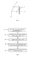
- Figure 1 is a schematic view of a seismic block, showing one trace only for the sake of clarity.
- seismic block is used for describing a set of measurements, over a given geographical field, after processing to produce an image.
- the term seismic block is used for describing a set of measurements, over a given geographical field, after processing to produce an image.
- one uses an orthogonal and normalized set of coordinates, in which the x and y axes lie in the horizontal plane.
- the z-axis which corresponds to time, is vertical and oriented downward.
- one uses the coordinates (x, y, t) for a temporal representation of the survey, or the coordinates (x, y, z) after depth migration to a spatial representation of the survey.
- the sensors may be hydrophones in streamers which are typically towed at 5-7m depth; alternatively receiver cables may be placed on the ocean bottom; even land geophones may sometimes be buried a few metres deep.
- a raw signal is recorded on each sensor C i ; this raw signal is representative of the seismic waves reflected by the various interfaces in the sub-surface.
- Raw signals received on sensors are then processed to provide an image of the sub-surface comprised of a collection of vertical seismic traces, the vertical axis representing time t or depth z.
- Figure 1 shows the axes x, y and t (or z) of the set of coordinates, as well as one sensor C i with the corresponding trace, referenced 2 on the figure.
- figure 1 only shows one sensor and one trace, while a survey would typically involve many sensors and a number of traces higher than one million.
- seismic processing will place the seismic events as accurately as possible in their true lateral positions. In the idealised case of zero dip and zero offset, with no lateral velocity gradients, this would be directly beneath the sensors, but in general the positions will be effectively independent of the original positions of the sensors.
- FIG. 2 is a flowchart of a process according to one embodiment of the invention.
- step 12 there is provided a base survey of the reservoir, with a set of seismic traces at a first time T.
- the base survey provides an amplitude b(t), that is an amplitude which is a function of time t; with digital recording and processing the trace is sampled at a set of values t i , with i an index; typical trace lengths correspond to around 1000 samples at a 4 ms sampling period.
- the trace is then handled as a set of values b(t i ) or b i .
- one provides a monitor survey of the reservoir, taken at a second time T + ⁇ T, with a set of seismic traces.
- ⁇ T is a positive quantity
- the monitor survey is taken at a time later than the base survey; however, the order in which the surveys are taken is irrelevant to the operation of the process of the invention and, in principle, the time lapse ⁇ T could as well be negative - which amounts to comparing the earlier survey to the later one.
- a sampled trace in the monitor survey is represented as a set of values m(t i ) or m i .
- the traces in the monitor survey are associated to the same positions as in the base survey. This is carried out by using, inasmuch as possible, the same equipment, acquisition geometry and processes for running the base survey and monitor survey. Practically speaking, a difference of 5-10 m between the positions of sources and receivers still leads to acceptable results. Techniques such as interpolation may be used in case traces in the monitor survey and in the base survey do not fulfil this condition ( Eiken, O., et al., 2003, A proven method for acquiring highly repeatable towed streamer seismic data, Geophysics, 68, 1303-1309 ).
- V b and V m are notionally the local vertical velocities, considered for 3D warping. They do not in general match any velocities used in prior seismic processing, that is migration velocities or stacking velocities. Their difference is indicative of vertical time shifts of seismic events between base and monitor.
- This relative slowness change, n may be assessed in each sample of the seismic block, that is in each sample of a trace. For estimating the relative slowness change, one uses optimization over a set of points, as explained below.
- This expression is representative of the fact that the time shift w i for sample i on the trace is caused by velocity changes above the sample. Strictly speaking, the time shift is the integrated change of slowness over the path followed by the signal from the source to the sample being considered and back.
- the expression given above is based on the assumption that time shifts derive from velocity changes above the sample being considered; this corresponds to a vertical or quasi-vertical propagation path from source to reflector and back to the sensor.
- the second term is representative of the effect of the local change of reflectivity, consequent upon the velocity change, on the trace; in this second term, local change is considered in a time range commensurate to the wavelet, that is in a time range equal to the duration of the wavelet.
- This difference ⁇ i is the difference between the amplitude b i of the seismic trace in the base survey at the point i and the sum of
- This provides a field of velocity changes, for the various points.
- the field of velocity changes parameterises a warping operation for aligning the monitor survey with the base and may also be used for directly characterizing the evolution of the reservoir.
- step 16 of the process of figure 2 a set of points is selected; the sum S will be minimized on this set of points.
- the size of the set of points may vary, but these will normally be chosen to completely include the full volume of the reservoir under consideration.
- the traces from the entire base and monitor surveys, windowed in time to span the reservoir are used. This will provide values of velocity changes over the complete surveys.
- step 20 of the process the sum S is minimized, by varying the values of the relative velocity changes.
- An optimization technique is provided below; however, one may also use other optimization techniques known per se in the art, such as simulated annealing. If, as suggested above, the seismic events in the monitor survey are not displaced laterally from their positions in the base survey, points are only time-shifted. One may then carry out the computation on a trace-by-trace basis; in other words, optimization may be carried out separately on each trace. This simplifies computation and makes it easier to run the optimization step as parallel tasks on a number of computers.
- step 22 the minimum of sum S has been attained, and this provides a value of velocity change for the various points of the set of points over which the optimization was carried out.
- the field of velocity changes associated with the minimum of the sum S characterizes the evolution of the reservoir over time.
- the wavelet may be scaled accordingly. For example, if there is a positive correlation such that, on average, a 1% change in velocity implies a 0.25% change in density, the wavelet could be scaled by a factor 1.25 so as to give the most probable representation of the change in the trace resulting from the velocity perturbation.
- the process of figure 2 was applied to surveys of the Girassol field.
- the base survey was carried out in the year 1999 by CGG as a high-resolution survey, with sampling of 2ms. Production started in 2001, and the monitor survey was carried out in the year 2002, using the same equipment as the base survey.
- Each survey comprises 2.5 million traces, of around 2000 samples each, which were windowed to 500 samples for the application of the method described herein, in the embodiment detailed above.
- the process of figure 2 was carried out using the velocity field originally modelled for the base survey; the velocity field for processing the monitor survey was taken to be the same as that of the base, for the purpose of the time-lapse comparison. Since the base and monitor surveys were carried out under very similar conditions, and dips are small, optimization was carried out on a trace by trace basis. The process was carried out in 20 hours on 60 processors in parallel, that is around 1200 CPU hours; convergence was achieved in 3 iterations in the optimization process.
- the evaluation of the difference ⁇ i will take the amplitude value from the monitor seismic block which has been displaced not only by a time shift, but also by a change in lateral position.
- the overall displacements between the migrated images are due to velocity changes along the propagation paths, which are no longer vertical; for a given point i, the corresponding point i' is then shifted in time and in space along the propagation path defined by the migration process which created the images, by an amount which corresponds to the integral, along the true propagation path, of the slowness changes in the earth.
- Figures 3-7 show a 2D synthetic test of the process of figure 2 ; the test was carried out by applying velocity changes to actual data, computing the monitor survey based on the velocity changes, and then applying the process for reconstructing the velocity changes.
- Figure 3 shows a section through the seismic image block derived from the base survey. This section is derived from actual data from the Girassol field, obtained by convolutional modelling of the p-wave impedance cube derived by inversion of the base seismic data. As discussed in reference to figure 1 , the horizontal axis shows the trace numbers - or the distance along the section; the vertical axis represents time. Amplitude appears in figure 3 for each trace; one sees that the dip in the reservoir is substantially zero, with maximum values of dip around 3° and RMS values of dip in the reservoir around 1.5°.
- Figure 4 shows the velocity changes imposed in the synthetic test.
- the velocity change has a "butterfly", design, which gives easy appreciation of the inversion result and the potential resolution and stability of the method.
- velocity changes are positive, with a constant value of +8%; on the right side of the butterfly, velocity changes are negative, with a constant value of -8%.
- Figure 5 shows the changes of amplitude caused by the velocity changes of figure 4 . Specifically, figure 5 results from
- Figure 6 shows the results of the process of figure 2 . It shows the differences in amplitudes, after minimising sum S, between the base and the shifted monitor surveys, revealing the estimated changes in amplitudes due to the change of reflectivity only. In the example, optimization was carried out on a trace by trace basis, and converged in 3 iterations.
- Figure 6 shows that amplitude changes substantially reflect the velocity changes of figure 3 ; this shows the efficacy of the process. In particular the alignment of the traces below the velocity changes is sufficiently good that the difference traces are effectively zero in this region.
- Figure 7 shows the velocity changes, computed during the process of optimization. Although there are some errors, figure 7 shows that the values of velocity changes are substantially those of figure 3 .
- Spectral analysis of the velocity perturbation shows that the inversion has a broad-band nature, with frequencies recovered from 0Hz out to the upper limit of the seismic spectrum, and thus that the inverted velocity change attribute may be quantitative and easily interpretable.
- Figures 8 and 9 show a more realistic 2D synthetic test of the process of figure 2 ; the test was carried out by applying velocity changes to actual data, with more complex velocity changes. Specifically, velocity changes were placed in interpreted sand bodies, as shown in figure 8 .
- Figure 9 shows the results obtained in the process of the invention; changes in velocity again substantially correspond to those of figure 8 . As in the example of figures 3-7 , the spectra of the estimated changes confirm the broad-band nature of the calculation.
- Figures 8 and 9 show that the process will also operate on velocity changes more complex that the ones of figure 3 .
- Figures 10-13 show the results obtained thanks to the process of figure 2 , on the actual surveys for the Girassol field.
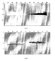
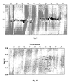
- Figure 10 is a section of the raw differences between the monitor survey and base survey, on Girassol fast-track near substacks; figure 10 is taken along crossline 4001 of the survey.
- Figure 11 shows the seismic amplitude difference computed in the process of figure 2 ; compared to figure 10 , one can see that the differences are now for the major part visible in the upper part of the section; this part corresponds to the portions of the reservoir wherefrom oil is being retrieved.
- figures 10-13 shows that the process of the invention provides results that are immediately usable and are also in accordance with exploration data.
- Spectral analysis of the data of figures 10-12 also shows, as in the previous examples, that lower frequencies are well recovered.
- figures 10-12 is carried out on the Girassol near substacks, where the average incidence angles amount to 12 degrees; therefore, even though the warp displacements may be vertical, they may not be exactly equal to the vertical integral of the superposed slowness changes; the example of figures 10-12 demonstrates that deviations from the assumption of zero-offset and dip which arise in real cases can be tolerated and the method yields results that appear realistic and quantitatively meaningful.
- the process of the invention may be embodied in a computer program.
- the program is adapted to receive data for the base and monitor surveys, as well as data for the velocity fields; such data are in the format provided by state of the art computer packages such as those discussed above.
- the program runs the various steps of the process of figure 2 .
Landscapes
- Physics & Mathematics (AREA)
- Life Sciences & Earth Sciences (AREA)
- Engineering & Computer Science (AREA)
- Remote Sensing (AREA)
- General Life Sciences & Earth Sciences (AREA)
- Acoustics & Sound (AREA)
- Environmental & Geological Engineering (AREA)
- Geology (AREA)
- General Physics & Mathematics (AREA)
- Geophysics (AREA)
- Fluid Mechanics (AREA)
- Geophysics And Detection Of Objects (AREA)
- Stereo-Broadcasting Methods (AREA)
- Financial Or Insurance-Related Operations Such As Payment And Settlement (AREA)
- Circuits Of Receivers In General (AREA)
- Lubrication Of Internal Combustion Engines (AREA)
- Measurement Of Mechanical Vibrations Or Ultrasonic Waves (AREA)
Claims (7)
- Procédé pour caractériser l'évolution d'un réservoir d'hydrocarbures en cours d'exploitation par co-analyse des variations des temps de propagation et amplitudes séismiques d'une ondelette séismique le long de chemins de propagation dans le sol, comprenant les étapes consistant à :- fournir (12) un relevé de base du réservoir avec un ensemble de traces séismiques à un premier moment T associé à une première vitesse Vb ;- fournir (16) un relevé de surveillance du réservoir, pris à un deuxième moment T + ΔT, avec un ensemble de traces séismiques associées aux mêmes positions que dans le relevé de base, associé à une deuxième vitesse Vm ;- pour un ensemble de points du relevé de base, calculer (18) la somme S sur les points de l'ensemble d'une norme de la différence entre l'amplitude bi de la trace séismique dans le relevé de base audit point i et la somme de l'amplitude mi, de la trace séismique à un point i' correspondant dans le temps dans le relevé de surveillance et l'amplitude due à la variation de réflectivité locale audit point i' correspondant dans le temps, induite par la variation relative de la vitesse de la terre dans et autour du réservoir, qui est la différence entre la première vitesse Vb et la deuxième vitesse Vm ,
le point i' correspondant dans le temps étant décalé temporellement par un décalage temporel obtenu à partir des variations de vitesse le long du chemin de propagation de la surface jusqu'audit point i' correspondant dans le temps;- caractériser (22) l'évolution du réservoir en minimisant la somme S. - Procédé selon la revendication 1, dans lequel l'amplitude due à une variation de réflectivité locale audit point correspondant dans le temps est calculée sur un intervalle de temps de un à cinq fois la longueur d'une ondelette utilisée dans les relevés.
- Procédé selon la revendication 1 ou 2, dans lequel un point i' correspondant est décalé seulement dans le temps.
- Procédé selon la revendication 3, dans lequel l'étape d'optimisation est réalisée trace par trace.
- Procédé selon la revendication 1 ou 2, dans lequel un point i' correspondant est décalé temporellement et spatialement le long du chemin de propagation.
- Procédé selon l'une des revendications 1 à 5, comprenant en outre avant l'étape de calcul, l'étape consistant à décaler le zéro d'un relevé.
- Programme d'ordinateur sur un support lisible par ordinateur comprenant des moyens de code de programme d'ordinateur adaptés pour exécuter sur un ordinateur toutes les étapes du procédé selon l'une des revendications 1 à 6.
Priority Applications (6)
| Application Number | Priority Date | Filing Date | Title |
|---|---|---|---|
| EP06290912A EP1865340B1 (fr) | 2006-06-06 | 2006-06-06 | Procédé et programme pour la caractérisation temporelle d'un réservoir de pétrole |
| AT06290912T ATE483175T1 (de) | 2006-06-06 | 2006-06-06 | Verfahren und programm zur charakterisierung der zeitlichen entwicklung eines erdölvorkommens |
| DE602006017186T DE602006017186D1 (de) | 2006-06-06 | 2006-06-06 | Verfahren und Programm zur Charakterisierung der zeitlichen Entwicklung eines Erdölvorkommens |
| US11/751,883 US7577061B2 (en) | 2006-06-06 | 2007-05-22 | Process and program for characterising evolution of an oil reservoir over time |
| NO20072844A NO338866B1 (no) | 2006-06-06 | 2007-06-05 | Prosess og datamaskinprogram for karakterisering av utviklingen av et oljereservoar over tid |
| CN2007101104629A CN101086535B (zh) | 2006-06-06 | 2007-06-05 | 表征油藏随时间演变的方法和程序 |
Applications Claiming Priority (1)
| Application Number | Priority Date | Filing Date | Title |
|---|---|---|---|
| EP06290912A EP1865340B1 (fr) | 2006-06-06 | 2006-06-06 | Procédé et programme pour la caractérisation temporelle d'un réservoir de pétrole |
Publications (2)
| Publication Number | Publication Date |
|---|---|
| EP1865340A1 EP1865340A1 (fr) | 2007-12-12 |
| EP1865340B1 true EP1865340B1 (fr) | 2010-09-29 |
Family
ID=37199201
Family Applications (1)
| Application Number | Title | Priority Date | Filing Date |
|---|---|---|---|
| EP06290912A Not-in-force EP1865340B1 (fr) | 2006-06-06 | 2006-06-06 | Procédé et programme pour la caractérisation temporelle d'un réservoir de pétrole |
Country Status (6)
| Country | Link |
|---|---|
| US (1) | US7577061B2 (fr) |
| EP (1) | EP1865340B1 (fr) |
| CN (1) | CN101086535B (fr) |
| AT (1) | ATE483175T1 (fr) |
| DE (1) | DE602006017186D1 (fr) |
| NO (1) | NO338866B1 (fr) |
Cited By (3)
| Publication number | Priority date | Publication date | Assignee | Title |
|---|---|---|---|---|
| US10132945B2 (en) | 2014-07-11 | 2018-11-20 | Total S.A. | Method for obtaining estimates of a model parameter so as to characterise the evolution of a subsurface volume |
| US10379244B2 (en) | 2015-01-06 | 2019-08-13 | Total S.A. | Method for obtaining estimates of a model parameter so as to characterise the evolution of a subsurface volume over a time period |
| US10705237B2 (en) | 2014-07-11 | 2020-07-07 | Total S.A. | Method of constraining an inversion in the characterisation of the evolution of a subsurface volume |
Families Citing this family (42)
| Publication number | Priority date | Publication date | Assignee | Title |
|---|---|---|---|---|
| BRPI0810840A2 (pt) * | 2007-05-09 | 2014-10-29 | Exxonmobil Upstream Res Co | Métodos para inversão de dados sísmicos de lapso de tempo e para produzir hidrocarbonetos a partir de uma formação em uma região de sub-superfície |
| FR2918066B1 (fr) | 2007-06-26 | 2010-11-19 | Total France | Liant concentre non gelifiable et pompable pour bitume/polymere |
| US8548782B2 (en) * | 2007-08-24 | 2013-10-01 | Exxonmobil Upstream Research Company | Method for modeling deformation in subsurface strata |
| US8768672B2 (en) * | 2007-08-24 | 2014-07-01 | ExxonMobil. Upstream Research Company | Method for predicting time-lapse seismic timeshifts by computer simulation |
| WO2009109663A2 (fr) * | 2008-03-07 | 2009-09-11 | Shell Internationale Research Maatschappij B.V. | Procédé de réalisation de relevés sismiques marins temporisés |
| FR2929616B1 (fr) * | 2008-04-08 | 2011-09-09 | Total France | Procede de reticulation de compositions bitume/polymere presentant des emissions reduites d'hydrogene sulfure |
| EP2288974A1 (fr) | 2008-04-17 | 2011-03-02 | Exxonmobil Upstream Research Company | Outil de support de decision basee sur une optimisation robuste, utilise dans la planification de developpement de reservoir |
| BRPI0909446A2 (pt) | 2008-04-18 | 2015-12-22 | Exxonmobil Upstream Res Co | métodos para planejamento do desenvolvimento de reservatório, para suporte à decisão considerando o desenvolvimento de recurso petrolíferos, para otimização do planejamento de desenvolvimento, e para produção de hidrocarbonetos. |
| WO2009131761A2 (fr) | 2008-04-21 | 2009-10-29 | Exxonmobile Upstream Research Company | Outil d’aide à la décision basé sur une programmation stochastique pour la planification de développement d’un réservoir |
| FR2933499B1 (fr) | 2008-07-03 | 2010-08-20 | Inst Francais Du Petrole | Methode d'inversion conjointe de donnees sismiques representees sur des echelles de temps differentes |
| WO2010077568A1 (fr) | 2008-12-17 | 2010-07-08 | Exxonmobil Upstream Research Company | Système et procédé pour effectuer des relevés répétitifs de contrôle avec des données de contrôle éparses |
| WO2010077569A1 (fr) | 2008-12-17 | 2010-07-08 | Exxonmobil Upstream Research Company | Système et procédé de reconstruction de données répétitives |
| US8705317B2 (en) | 2008-12-17 | 2014-04-22 | Exxonmobil Upstream Research Company | Method for imaging of targeted reflectors |
| US8451683B2 (en) * | 2009-04-03 | 2013-05-28 | Exxonmobil Upstream Research Company | Method for determining the fluid/pressure distribution of hydrocarbon reservoirs from 4D seismic data |
| US8332154B2 (en) | 2009-06-02 | 2012-12-11 | Exxonmobil Upstream Research Company | Estimating reservoir properties from 4D seismic data |
| US9110190B2 (en) | 2009-06-03 | 2015-08-18 | Geoscale, Inc. | Methods and systems for multicomponent time-lapse seismic measurement to calculate time strains and a system for verifying and calibrating a geomechanical reservoir simulator response |
| GB2470760B (en) * | 2009-06-04 | 2013-07-24 | Total Sa | An improved process for characterising the evolution of an oil or gas reservoir over time |
| CN101625420B (zh) * | 2009-07-22 | 2012-05-09 | 中国石化集团胜利石油管理局 | 一种油藏描述的方法 |
| CA2776487C (fr) | 2009-11-12 | 2017-02-14 | Exxonmobil Upstream Research Company | Procede et appareil pour generer un maillage tridimensionnel de simulation pour un modele de reservoir |
| GB2479347B (en) * | 2010-04-06 | 2015-10-21 | Total Sa | A process of characterising the evolution of an oil reservoir |
| GB2481444B (en) | 2010-06-25 | 2016-08-17 | Total Sa | An improved process for characterising the evolution of an oil or gas reservoir over time |
| FR2963111B1 (fr) | 2010-07-21 | 2012-09-28 | Total Sa | Procede d'estimation de parametres elastiques par inversion de mesures sismiques 4d |
| US8040754B1 (en) | 2010-08-27 | 2011-10-18 | Board Of Regents Of The University Of Texas System | System and method for acquisition and processing of elastic wavefield seismic data |
| US8243548B2 (en) | 2010-08-27 | 2012-08-14 | Board Of Regents Of The University Of Texas System | Extracting SV shear data from P-wave seismic data |
| US8325559B2 (en) | 2010-08-27 | 2012-12-04 | Board Of Regents Of The University Of Texas System | Extracting SV shear data from P-wave marine data |
| FR2965066B1 (fr) * | 2010-09-20 | 2012-10-26 | Total Sa | Procede d'estimation de parametres elastiques |
| GB2489677A (en) * | 2011-03-29 | 2012-10-10 | Total Sa | Characterising the evolution of a reservoir over time from seismic surveys, making allowance for actual propagation paths through non-horizontal layers |
| ES2869401T3 (es) * | 2011-07-12 | 2021-10-25 | Colorado School Of Mines | Análisis de velocidad de migración de ecuación de onda usando deformación de imágenes |
| WO2014018704A1 (fr) * | 2012-07-25 | 2014-01-30 | Schlumberger Canada Limited | Procédés permettant l'interprétation de données sismiques répétitives de trou de forage pour permettre une surveillance de réservoir |
| WO2014177633A2 (fr) * | 2013-05-01 | 2014-11-06 | Cgg Services Sa | Dispositif et procédé d'optimisation de données sismiques 3d et 4d |
| WO2015092542A2 (fr) * | 2013-12-16 | 2015-06-25 | Cgg Services Sa | Inversion simultanée accélérée d'amplitudes et décalages temporels contraints par des cartes d'entrée calculées au préalable |
| CN103643949B (zh) * | 2013-12-20 | 2016-06-01 | 中国石油天然气集团公司 | 一种储层含油气的定量预测方法及装置 |
| GB2523109B (en) | 2014-02-12 | 2020-07-29 | Total E&P Uk Ltd | A process for characterising the evolution of an oil or gas reservoir over time |
| FR3019908B1 (fr) * | 2014-04-14 | 2016-05-06 | Total Sa | Procede de traitement d'images sismiques |
| WO2016046633A1 (fr) * | 2014-09-22 | 2016-03-31 | Cgg Services Sa | Inversion simultanée de formes d'onde complètes répétitives de multiples millésimes |
| CN109804273B (zh) * | 2016-10-06 | 2022-01-11 | 国际壳牌研究有限公司 | 使用地震波进行井眼时移监测的方法 |
| US11313987B2 (en) | 2017-08-17 | 2022-04-26 | Total S.A. | Method for obtaining estimates of a model parameter so as to characterise the evolution of a subsurface volume over a time period using time-lapse seismic |
| WO2019157031A1 (fr) * | 2018-02-06 | 2019-08-15 | Conocophillips Company | Technique sismique 4d en tant que procédé de caractérisation d'un réseau de fractures et distribution de fluide dans un réservoir non conventionnel |
| CN110888162B (zh) * | 2018-09-07 | 2021-09-17 | 中国石油化工股份有限公司 | 一种基于热力学统计的同相轴连续性增强方法及系统 |
| CN111856559B (zh) * | 2019-04-30 | 2023-02-28 | 中国石油天然气股份有限公司 | 基于稀疏贝叶斯学习理论的多道地震谱反演方法及系统 |
| EA202192926A1 (ru) * | 2019-05-02 | 2022-03-24 | Бп Корпорейшн Норт Америка Инк. | 4d совместная инверсия временного сдвига и амплитуды для изменения скорости |
| US11372123B2 (en) | 2019-10-07 | 2022-06-28 | Exxonmobil Upstream Research Company | Method for determining convergence in full wavefield inversion of 4D seismic data |
Family Cites Families (5)
| Publication number | Priority date | Publication date | Assignee | Title |
|---|---|---|---|---|
| US6041018A (en) * | 1997-11-13 | 2000-03-21 | Colorado School Of Mines | Method for correcting amplitude and phase differences between time-lapse seismic surveys |
| CN1186648C (zh) * | 2001-09-30 | 2005-01-26 | 中海油田服务股份有限公司 | 油藏测试地面数据采集处理系统及其数据采集处理方法和设备 |
| US7242637B2 (en) * | 2003-10-24 | 2007-07-10 | Shell Oil Company | Time-lapse seismic survey of a reservoir region |
| GB2409900B (en) | 2004-01-09 | 2006-05-24 | Statoil Asa | Processing seismic data representing a physical system |
| US7626887B2 (en) * | 2006-04-19 | 2009-12-01 | Westerngeco L.L.C. | Displacement field calculation |
-
2006
- 2006-06-06 AT AT06290912T patent/ATE483175T1/de not_active IP Right Cessation
- 2006-06-06 EP EP06290912A patent/EP1865340B1/fr not_active Not-in-force
- 2006-06-06 DE DE602006017186T patent/DE602006017186D1/de active Active
-
2007
- 2007-05-22 US US11/751,883 patent/US7577061B2/en active Active
- 2007-06-05 CN CN2007101104629A patent/CN101086535B/zh not_active Expired - Fee Related
- 2007-06-05 NO NO20072844A patent/NO338866B1/no unknown
Cited By (3)
| Publication number | Priority date | Publication date | Assignee | Title |
|---|---|---|---|---|
| US10132945B2 (en) | 2014-07-11 | 2018-11-20 | Total S.A. | Method for obtaining estimates of a model parameter so as to characterise the evolution of a subsurface volume |
| US10705237B2 (en) | 2014-07-11 | 2020-07-07 | Total S.A. | Method of constraining an inversion in the characterisation of the evolution of a subsurface volume |
| US10379244B2 (en) | 2015-01-06 | 2019-08-13 | Total S.A. | Method for obtaining estimates of a model parameter so as to characterise the evolution of a subsurface volume over a time period |
Also Published As
| Publication number | Publication date |
|---|---|
| NO20072844L (no) | 2007-12-07 |
| CN101086535B (zh) | 2011-12-07 |
| US20080291781A1 (en) | 2008-11-27 |
| CN101086535A (zh) | 2007-12-12 |
| ATE483175T1 (de) | 2010-10-15 |
| US7577061B2 (en) | 2009-08-18 |
| DE602006017186D1 (de) | 2010-11-11 |
| NO338866B1 (no) | 2016-10-31 |
| EP1865340A1 (fr) | 2007-12-12 |
Similar Documents
| Publication | Publication Date | Title |
|---|---|---|
| US7577061B2 (en) | Process and program for characterising evolution of an oil reservoir over time | |
| EP4042210B1 (fr) | Détermination des propriétés d'une formation souterraine à l'aide d'une équation d'onde acoustique ayant un paramétrage de réflectivité | |
| US11428834B2 (en) | Processes and systems for generating a high-resolution velocity model of a subterranean formation using iterative full-waveform inversion | |
| US8352190B2 (en) | Method for analyzing multiple geophysical data sets | |
| CA2775561C (fr) | Determination d'eclairage basee sur une migration pour evaluation de risque a analyse de valeur moyenne | |
| AU2013200475B2 (en) | Methods and systems for correction of streamer-depth bias in marine seismic surveys | |
| US20130289879A1 (en) | Process for characterising the evolution of a reservoir | |
| CA2940406C (fr) | Caracterisation d'une structure physique a l'aide d'un modele de bruit multidimensionnel pour attenuer des donnees bruitees | |
| US20100131205A1 (en) | Method for identifying and analyzing faults/fractures using reflected and diffracted waves | |
| EP3359982B1 (fr) | Orientation de capteur sismique | |
| CN101999086A (zh) | 用于确定地震数据质量的方法 | |
| US12360271B2 (en) | Methods and systems for generating an image of a subterranean formation based on low frequency reconstructed seismic data | |
| US20240310540A1 (en) | Determining angle gathers from inversion of velocity and reflectivity of a subterranean formation | |
| WO2024194150A1 (fr) | Détermination de regroupements d'angles à partir de l'inversion de la vitesse et de la réflectivité d'une formation souterraine | |
| Woo et al. | Improvement of fault interpretation with seismic attribute analysis of Jeju Basin, offshore southern Korea, East China Sea |
Legal Events
| Date | Code | Title | Description |
|---|---|---|---|
| PUAI | Public reference made under article 153(3) epc to a published international application that has entered the european phase |
Free format text: ORIGINAL CODE: 0009012 |
|
| AK | Designated contracting states |
Kind code of ref document: A1 Designated state(s): AT BE BG CH CY CZ DE DK EE ES FI FR GB GR HU IE IS IT LI LT LU LV MC NL PL PT RO SE SI SK TR |
|
| AX | Request for extension of the european patent |
Extension state: AL BA HR MK YU |
|
| 17P | Request for examination filed |
Effective date: 20080612 |
|
| 17Q | First examination report despatched |
Effective date: 20080715 |
|
| AKX | Designation fees paid |
Designated state(s): AT BE BG CH CY CZ DE DK EE ES FI FR GB GR HU IE IS IT LI LT LU LV MC NL PL PT RO SE SI SK TR |
|
| GRAP | Despatch of communication of intention to grant a patent |
Free format text: ORIGINAL CODE: EPIDOSNIGR1 |
|
| GRAS | Grant fee paid |
Free format text: ORIGINAL CODE: EPIDOSNIGR3 |
|
| GRAJ | Information related to disapproval of communication of intention to grant by the applicant or resumption of examination proceedings by the epo deleted |
Free format text: ORIGINAL CODE: EPIDOSDIGR1 |
|
| GRAL | Information related to payment of fee for publishing/printing deleted |
Free format text: ORIGINAL CODE: EPIDOSDIGR3 |
|
| GRAP | Despatch of communication of intention to grant a patent |
Free format text: ORIGINAL CODE: EPIDOSNIGR1 |
|
| GRAS | Grant fee paid |
Free format text: ORIGINAL CODE: EPIDOSNIGR3 |
|
| GRAA | (expected) grant |
Free format text: ORIGINAL CODE: 0009210 |
|
| AK | Designated contracting states |
Kind code of ref document: B1 Designated state(s): AT BE BG CH CY CZ DE DK EE ES FI FR GB GR HU IE IS IT LI LT LU LV MC NL PL PT RO SE SI SK TR |
|
| REG | Reference to a national code |
Ref country code: GB Ref legal event code: FG4D |
|
| REG | Reference to a national code |
Ref country code: CH Ref legal event code: EP |
|
| REG | Reference to a national code |
Ref country code: IE Ref legal event code: FG4D |
|
| REF | Corresponds to: |
Ref document number: 602006017186 Country of ref document: DE Date of ref document: 20101111 Kind code of ref document: P |
|
| PG25 | Lapsed in a contracting state [announced via postgrant information from national office to epo] |
Ref country code: FI Free format text: LAPSE BECAUSE OF FAILURE TO SUBMIT A TRANSLATION OF THE DESCRIPTION OR TO PAY THE FEE WITHIN THE PRESCRIBED TIME-LIMIT Effective date: 20100929 Ref country code: LT Free format text: LAPSE BECAUSE OF FAILURE TO SUBMIT A TRANSLATION OF THE DESCRIPTION OR TO PAY THE FEE WITHIN THE PRESCRIBED TIME-LIMIT Effective date: 20100929 Ref country code: AT Free format text: LAPSE BECAUSE OF FAILURE TO SUBMIT A TRANSLATION OF THE DESCRIPTION OR TO PAY THE FEE WITHIN THE PRESCRIBED TIME-LIMIT Effective date: 20100929 |
|
| REG | Reference to a national code |
Ref country code: NL Ref legal event code: VDEP Effective date: 20100929 |
|
| LTIE | Lt: invalidation of european patent or patent extension |
Effective date: 20100929 |
|
| PG25 | Lapsed in a contracting state [announced via postgrant information from national office to epo] |
Ref country code: SI Free format text: LAPSE BECAUSE OF FAILURE TO SUBMIT A TRANSLATION OF THE DESCRIPTION OR TO PAY THE FEE WITHIN THE PRESCRIBED TIME-LIMIT Effective date: 20100929 |
|
| PG25 | Lapsed in a contracting state [announced via postgrant information from national office to epo] |
Ref country code: LV Free format text: LAPSE BECAUSE OF FAILURE TO SUBMIT A TRANSLATION OF THE DESCRIPTION OR TO PAY THE FEE WITHIN THE PRESCRIBED TIME-LIMIT Effective date: 20100929 Ref country code: GR Free format text: LAPSE BECAUSE OF FAILURE TO SUBMIT A TRANSLATION OF THE DESCRIPTION OR TO PAY THE FEE WITHIN THE PRESCRIBED TIME-LIMIT Effective date: 20101230 Ref country code: SE Free format text: LAPSE BECAUSE OF FAILURE TO SUBMIT A TRANSLATION OF THE DESCRIPTION OR TO PAY THE FEE WITHIN THE PRESCRIBED TIME-LIMIT Effective date: 20100929 |
|
| PG25 | Lapsed in a contracting state [announced via postgrant information from national office to epo] |
Ref country code: SK Free format text: LAPSE BECAUSE OF FAILURE TO SUBMIT A TRANSLATION OF THE DESCRIPTION OR TO PAY THE FEE WITHIN THE PRESCRIBED TIME-LIMIT Effective date: 20100929 Ref country code: NL Free format text: LAPSE BECAUSE OF FAILURE TO SUBMIT A TRANSLATION OF THE DESCRIPTION OR TO PAY THE FEE WITHIN THE PRESCRIBED TIME-LIMIT Effective date: 20100929 Ref country code: IS Free format text: LAPSE BECAUSE OF FAILURE TO SUBMIT A TRANSLATION OF THE DESCRIPTION OR TO PAY THE FEE WITHIN THE PRESCRIBED TIME-LIMIT Effective date: 20110129 Ref country code: IT Free format text: LAPSE BECAUSE OF FAILURE TO SUBMIT A TRANSLATION OF THE DESCRIPTION OR TO PAY THE FEE WITHIN THE PRESCRIBED TIME-LIMIT Effective date: 20100929 Ref country code: CZ Free format text: LAPSE BECAUSE OF FAILURE TO SUBMIT A TRANSLATION OF THE DESCRIPTION OR TO PAY THE FEE WITHIN THE PRESCRIBED TIME-LIMIT Effective date: 20100929 Ref country code: EE Free format text: LAPSE BECAUSE OF FAILURE TO SUBMIT A TRANSLATION OF THE DESCRIPTION OR TO PAY THE FEE WITHIN THE PRESCRIBED TIME-LIMIT Effective date: 20100929 Ref country code: PT Free format text: LAPSE BECAUSE OF FAILURE TO SUBMIT A TRANSLATION OF THE DESCRIPTION OR TO PAY THE FEE WITHIN THE PRESCRIBED TIME-LIMIT Effective date: 20110131 Ref country code: RO Free format text: LAPSE BECAUSE OF FAILURE TO SUBMIT A TRANSLATION OF THE DESCRIPTION OR TO PAY THE FEE WITHIN THE PRESCRIBED TIME-LIMIT Effective date: 20100929 |
|
| PG25 | Lapsed in a contracting state [announced via postgrant information from national office to epo] |
Ref country code: BE Free format text: LAPSE BECAUSE OF FAILURE TO SUBMIT A TRANSLATION OF THE DESCRIPTION OR TO PAY THE FEE WITHIN THE PRESCRIBED TIME-LIMIT Effective date: 20100929 |
|
| PG25 | Lapsed in a contracting state [announced via postgrant information from national office to epo] |
Ref country code: ES Free format text: LAPSE BECAUSE OF FAILURE TO SUBMIT A TRANSLATION OF THE DESCRIPTION OR TO PAY THE FEE WITHIN THE PRESCRIBED TIME-LIMIT Effective date: 20110109 |
|
| PLBE | No opposition filed within time limit |
Free format text: ORIGINAL CODE: 0009261 |
|
| STAA | Information on the status of an ep patent application or granted ep patent |
Free format text: STATUS: NO OPPOSITION FILED WITHIN TIME LIMIT |
|
| PG25 | Lapsed in a contracting state [announced via postgrant information from national office to epo] |
Ref country code: PL Free format text: LAPSE BECAUSE OF FAILURE TO SUBMIT A TRANSLATION OF THE DESCRIPTION OR TO PAY THE FEE WITHIN THE PRESCRIBED TIME-LIMIT Effective date: 20100929 Ref country code: DK Free format text: LAPSE BECAUSE OF FAILURE TO SUBMIT A TRANSLATION OF THE DESCRIPTION OR TO PAY THE FEE WITHIN THE PRESCRIBED TIME-LIMIT Effective date: 20100929 |
|
| REG | Reference to a national code |
Ref country code: DE Ref legal event code: R097 Ref document number: 602006017186 Country of ref document: DE Effective date: 20110630 |
|
| REG | Reference to a national code |
Ref country code: CH Ref legal event code: PL |
|
| REG | Reference to a national code |
Ref country code: IE Ref legal event code: MM4A |
|
| REG | Reference to a national code |
Ref country code: DE Ref legal event code: R119 Ref document number: 602006017186 Country of ref document: DE Effective date: 20120103 |
|
| PG25 | Lapsed in a contracting state [announced via postgrant information from national office to epo] |
Ref country code: IE Free format text: LAPSE BECAUSE OF NON-PAYMENT OF DUE FEES Effective date: 20110606 Ref country code: CH Free format text: LAPSE BECAUSE OF NON-PAYMENT OF DUE FEES Effective date: 20110630 Ref country code: LI Free format text: LAPSE BECAUSE OF NON-PAYMENT OF DUE FEES Effective date: 20110630 Ref country code: DE Free format text: LAPSE BECAUSE OF NON-PAYMENT OF DUE FEES Effective date: 20120103 |
|
| PG25 | Lapsed in a contracting state [announced via postgrant information from national office to epo] |
Ref country code: MC Free format text: LAPSE BECAUSE OF NON-PAYMENT OF DUE FEES Effective date: 20110630 |
|
| PG25 | Lapsed in a contracting state [announced via postgrant information from national office to epo] |
Ref country code: LU Free format text: LAPSE BECAUSE OF NON-PAYMENT OF DUE FEES Effective date: 20110606 Ref country code: CY Free format text: LAPSE BECAUSE OF FAILURE TO SUBMIT A TRANSLATION OF THE DESCRIPTION OR TO PAY THE FEE WITHIN THE PRESCRIBED TIME-LIMIT Effective date: 20100929 |
|
| PG25 | Lapsed in a contracting state [announced via postgrant information from national office to epo] |
Ref country code: BG Free format text: LAPSE BECAUSE OF FAILURE TO SUBMIT A TRANSLATION OF THE DESCRIPTION OR TO PAY THE FEE WITHIN THE PRESCRIBED TIME-LIMIT Effective date: 20101229 Ref country code: TR Free format text: LAPSE BECAUSE OF FAILURE TO SUBMIT A TRANSLATION OF THE DESCRIPTION OR TO PAY THE FEE WITHIN THE PRESCRIBED TIME-LIMIT Effective date: 20100929 |
|
| PG25 | Lapsed in a contracting state [announced via postgrant information from national office to epo] |
Ref country code: HU Free format text: LAPSE BECAUSE OF FAILURE TO SUBMIT A TRANSLATION OF THE DESCRIPTION OR TO PAY THE FEE WITHIN THE PRESCRIBED TIME-LIMIT Effective date: 20100929 |
|
| REG | Reference to a national code |
Ref country code: FR Ref legal event code: PLFP Year of fee payment: 11 |
|
| REG | Reference to a national code |
Ref country code: FR Ref legal event code: PLFP Year of fee payment: 12 |
|
| REG | Reference to a national code |
Ref country code: FR Ref legal event code: PLFP Year of fee payment: 13 |
|
| REG | Reference to a national code |
Ref country code: FR Ref legal event code: PLFP Year of fee payment: 17 |
|
| P01 | Opt-out of the competence of the unified patent court (upc) registered |
Effective date: 20230524 |
|
| REG | Reference to a national code |
Ref country code: GB Ref legal event code: 732E Free format text: REGISTERED BETWEEN 20240530 AND 20240605 |
|
| PGFP | Annual fee paid to national office [announced via postgrant information from national office to epo] |
Ref country code: GB Payment date: 20240619 Year of fee payment: 19 |
|
| PGFP | Annual fee paid to national office [announced via postgrant information from national office to epo] |
Ref country code: FR Payment date: 20240628 Year of fee payment: 19 |
|
| GBPC | Gb: european patent ceased through non-payment of renewal fee |
Effective date: 20250606 |
|
| PG25 | Lapsed in a contracting state [announced via postgrant information from national office to epo] |
Ref country code: GB Free format text: LAPSE BECAUSE OF NON-PAYMENT OF DUE FEES Effective date: 20250606 |
|
| PG25 | Lapsed in a contracting state [announced via postgrant information from national office to epo] |
Ref country code: FR Free format text: LAPSE BECAUSE OF NON-PAYMENT OF DUE FEES Effective date: 20250630 |