EP1865343A1 - Procédé d'estimation et/ou de réduction d'incertitudes dans des modèles de réservoirs potentiels de pétrole - Google Patents
Procédé d'estimation et/ou de réduction d'incertitudes dans des modèles de réservoirs potentiels de pétrole Download PDFInfo
- Publication number
- EP1865343A1 EP1865343A1 EP07252312A EP07252312A EP1865343A1 EP 1865343 A1 EP1865343 A1 EP 1865343A1 EP 07252312 A EP07252312 A EP 07252312A EP 07252312 A EP07252312 A EP 07252312A EP 1865343 A1 EP1865343 A1 EP 1865343A1
- Authority
- EP
- European Patent Office
- Prior art keywords
- grid
- layer
- property
- properties
- realisations
- Prior art date
- Legal status (The legal status is an assumption and is not a legal conclusion. Google has not performed a legal analysis and makes no representation as to the accuracy of the status listed.)
- Withdrawn
Links
Images




Classifications
-
- G—PHYSICS
- G01—MEASURING; TESTING
- G01V—GEOPHYSICS; GRAVITATIONAL MEASUREMENTS; DETECTING MASSES OR OBJECTS; TAGS
- G01V11/00—Prospecting or detecting by methods combining techniques covered by two or more of main groups G01V1/00 - G01V9/00
-
- G—PHYSICS
- G01—MEASURING; TESTING
- G01V—GEOPHYSICS; GRAVITATIONAL MEASUREMENTS; DETECTING MASSES OR OBJECTS; TAGS
- G01V2210/00—Details of seismic processing or analysis
- G01V2210/60—Analysis
- G01V2210/66—Subsurface modeling
- G01V2210/665—Subsurface modeling using geostatistical modeling
Definitions
- the present invention relates to the general area of the analysis and interpretation of subsurface regions on the basis of seismic data, and in particular to the processing of seismic inversion data for use in reservoir models.
- the seismic inversion data produced by Delivery is an array of trace-local stochastic samples from a Bayesian posterior distribution of reservoir layer parameters, which contains complex correlations between layers boundaries, rock properties and fluid information, but no transverse correlations.
- This inversion data produced by the program is suitable for answering the simple kind of questions mentioned above, such as pointwise histograms of layer thickness, maps of hydrocarbon probability etc, but is not directly suitable for flow calculations per se.
- trend maps have been formed from the results of seismic inversion for properties such as porosity and net sand. These trend maps have then been used to control the geostatistical population of properties and/or objects into the reservoir simulation model.
- the models have also tended to be built at extremely fine scale (less then a few meters) then upscaled to a coarser scale for reservoir simulation (less than tens of meters).
- the present invention provides a new and improved method for estimating and/or reducing uncertainty in reservoir models of potential petroleum reservoirs, on the basis of seismic inversion information.
- the method provides for the conversion of the results of a stochastic seismic inversion into a set of realisations of a plurality of properties suitable for use in a reservoir model, while preserving inter-property and inter-layer correlations to reduce uncertainty. Geological constraints and well measurements may also be honoured in the realisations.
- the method comprises the steps of:
- the method further comprises the step of simulating the spatial dispersion of material within a layer of the seismic inversion by vertically subdividing the layer and modelling a vertical distribution of impermeable material within the layer consistently with a vertical average of impermeable material content obtained from the seismic inversion. This allows the output realisations to capture the effect on fluid flow of the dispersion of impermeable material, or shale, within the region to be modelled.
- inversion models are probabilistic, it is natural for the remapped or 'massaged' models to inherit this probabilistic character. Objects of interest will then naturally be the 'most likely' massaged model, as well as a suite of 'realisation' models, which enable stochastic forward flow simulations to be performed for risking purposes. Volumetric statistics of interest can of course be calculated oil the fly as well.
- the trace-based Bayesian inversion model implemented by Delivery is a typical input to the method of the invention, and produces an ensemble of realisations from the posterior distribution of the model parameters at each common midpoint (CMP) gather, or trace, of the imaged seismic data.
- CMP common midpoint
- the inversion model is quasi 1d, with a sequence of layers parametrised by times describing the (local) geometry, and each layer is characterised by a laminated mixture of permeable and impermeable rocks, with rock velocities, density, porosity and fluid content as additional model parameters.
- the depths of each layer are computed from relative traveltimes and velocities, hung from a nominated reference layer and supplied reference depth.
- the model parameters of interest are typically the layer depth 'd', the 'thickness', 'net-to-gross NG' (or N G ), fluid content 'net-hydrocarbon', and 'porosity' (to name the interesting quantities accessible from Delivery inversions in inverted commas).
- the Monte Carlo ensemble produced by the inversion encapsulates the coupling or correlations between these properties which is demanded by consistency with the seismic data and the prior model.
- the imaged traces are typically spaced anywhere from 15m to 200m apart, in a regular array, and the inversion does not model the coupling that may occur between model parameters at different traces, chiefly in order to make the inversion problem tractable (a more detailed discussion of these issues can be found in Gunning and Glinsky (2004)).
- Very strong lateral correlations are induced in the mean (or most-likely) posterior models by the prior and seismic data, but the overall distribution describing the model fluctuations formed by a naive resampling from the Delivery outputs is a product of trace-local distributions, and thus contains no lateral correlation.
- hard data for various properties will be available at well locations that have been logged, and is also used in the invention.
- the overall correlation matrix is then a direct (or Kronecker) product of correlation matrices, and the natural and efficient approximation to sampling from the Gaussian distribution attached to this correlation is a generalised p-field algorithm.
- the great advantage of this preferred approach is that it is only necessary to form approximations to the first and second order statistics (mean and covariance), and then simulation is direct.
- the median value is then a much better statistic for defining a most-likely model, since the mean of a skewed or truncated distribution is less likely than the median. Especially in the case of thicknesses, use of the mean statistic can often generate thin layers (sub seismic-resolution) over extensive areas of space. Obviously the multi-Gaussian model is a heavy approximation in this regime, so the means in the distribution have to be adjusted in this way to eliminate the worst biases. Output samples drawn from the 'massaged' distribution are obviously truncated in the same fashion.
- a first step the results of a stochastic seismic inversion are received, for example from the known Delivery inversion tool.
- the results provide output ensembles in respect of a plurality of properties on the basis of imaged seismic data obtained at points on an imaged seismic input grid over a region to be modelled, the output ensembles including information regarding the values of the plurality of properties at points on the input grid for a sequence of model layers, including means and covariances for the properties.
- information regarding an observed fault structure in the region is received, which may be estimated by a geologist.
- Measured well log data is then assembled in respect of one or more properties, obtained from well locations within the region. It should be noted that these three steps may be carried out in any order.
- the geometry of the input grid is modified, based on the observed fault structure, to form an output grid for each layer, onto which the property information will be mapped.
- the values of the properties are then interpolated from the points on the input grid onto the output grid, following which the means and covariances of the output ensembles are spatially smoothed to produce a smooth trend map for each property and a smooth inter-property trend covariance.
- a kriging adjustment of the property trends is then performed on the basis of the well log data, so that the trends pass through the well log data.
- a set of geological constraints may also be applied, including continuity requirements in respect of one or more properties between layers and/or across faults, in order to truncate or otherwise constrain some of the property values at given points. For example, certain properties will be continuous across faults, and others will not.
- a set of spatially correlated random fields is then simulated on the output grid for each property, preferably using a p-field technique, and used together with the smooth inter-property trend covariance and the property trend maps to generate a set of realisations for each property which honor inter-property and inter-layer correlations from the seismic inversion, measured well data and, where used, the set of geological constraints.
- the generated realisations may then be used in a reservoir model to conduct flow simulation and/or volumetric calculations in respect of the region, including the estimation of uncertainty in flow calculations.
- the geometry of the input grid is modified to form an output grid for each layer, based on an observed fault structure.
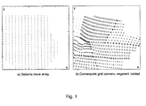
- Fig. 1.(a) shows a typical layout of an input-grid trace array for seismic inversion, with regular spaced points in a polygon.
- Fig. 1(b) shows a typical output grid for some layer, derived from ECLIPSE-style corner point grids with replication of grid points at fault planes. Different symbols identify segments or fault blocks.
- reservoir geological models are usually built with uneven spatial sampling, and often with less transverse resolution than that available in the seismic inversion.
- Various kinds of grid geometry are possible (Deutsch, 2002), but the present invention preferably uses the widely used cornerpoint grid format for exporting inversion information to reservoir modelling packages. These grids are used by the ECLIPSE reservoir simulator, so we use the adjectives 'cornerpoint' and 'Eclipse' as loosely interchangeable.
- Fig. 2. illustrates the architecture of corner point, grids. A typical normal fault is shown. Each layer's output grid is formed from the x, y projections of the edge midpoints (shown as little circles). Thickness and depth information can be shared by blocks that meet at a common points (A), but this information must be duplicated or triplicated at corners along the fault plane (B).
- Cornerpoint grids specify lines for the 'vertical' corners of each column of gridblocks, and a set of 8 depth ( z ) points which define the top and bottom face of any particular gridblock. (The faces are not strictly planar, but flow calculations make suitable projections so as to conserve mass and represent flux correctly).
- Blocks are indexed by an i, j, k triple , and usually many blocks are tagged as 'inactive' if they represent an uninteresting region of space.
- the file formats consist of chunks denoting the grid size, local origin, block-comer lines (COORD), corner-depths (ZCORN), and block-centred properties, such as 'active' flags, and segment labels.
- a 2d output grid comprising the ( x , y ) projections of the midpoints of the edges of each corner point block (see little circles in Fig. 2).
- Each such point has an associated 'segment' or 'fault-block' tag, and points along the fault plane are repeated according to the number of intersecting segments.
- Fig. 1 A typical plan view of the comerpoint geometry is shown in Fig. 1 (b).
- all properties are interpolated or simulated at the vertical center of the quasivertical block edges (i.e., the x-y corners).
- Block centred properties like porosity may be formed later by suitable 4-corner averages.
- the means and covariances of the multi-property Delivery output ensembles are spatially smoothed to produce a smooth, trend map for each property and a smooth between-properties trend covariance.
- the trend map may be allowed to have discontinuities at faults for certain properties.
- the property trends are then deformed by a kriging adjustment from well observations to produce a trend that passes through all hard observations.
- the estimation-variance maps produced in the kriging calculation are normalised and stored for each property, for later use.
- the maps may be truncated or clipped depending on consistency requirements for the properties (e.g.
- the trend maps then constitute the most-likely maps of properties.
- the uncertainty maps are defined by the diagonal entries of the smooth trend covariance multiplied by the kriging variance maps.
- the square root of the latter map is then a local 'standard deviation' for each property, which honors the inversion uncertainties and the well data.
- a set of normalised, spatially correlated random fields are simulated for each property and layer. At each spatial location these fields are then preferably mixed in a linear combination described by the Cholesky factor of the smoothed between-properties trend covariance.
- the final set of fields may then be scaled by the normalised kriging-variance maps and added to the trend maps to produce a series of realisations.
- the input grid ( G 1 ) The properties are to be generated on a different grid, called the output grid ( G 0 ). This is treated as a sequence of 2D grids for each layer, G 0 , 1 .
- the index / pertains to layers, p to properties, j to nodes on G 1 or a particular G 0,1 (as arranged in convenient ordering - say a raster scan).
- the set of hard well observations (O) may be suffixed l or p with implied constraint to layer l or property p .
- a vector m of properties of interest may be suffixed m ( l , p ) , which denotes a generic unrolled index of property p on layer l .
- Segment labels for node j are denoted S j .
- Neighbours are defined by a Euclidean distance metric confined to the same layer, with azimuth angle and principal ranges inherited from a conventional variogram specified by the user. Neighbours used in the trend smoothing are defined by the trend-smoothing variogram, whereas observation-kriging and simulations are associated with a separate, layer-specific 'interpolation' variogram. Since the grids are large and irregular in general, a kd-tree algorithm is preferably used for efficient nearest neighbour searching (Skiena, 1997). Nearest neighbour searches in the sequential simulation algorithms must be confined to previously visited nodes, and this may be achieved by a naive dynamic kd-tree implementation.
- the property vectors are re-ordered to the following sequence: ⁇ depth, thickness, net-sand, other properties ⁇ , if all the italicised properties are available. This enables truncation rules to be sensibly applied from known quantities later in the calculation.
- Fault-sensitive smoothing of the Delivery statistics requires a segment label to be attached to each input grid point.
- segments labels are associated with block centers.
- the input grid can then naturally inherit the segment label associated with the corner-point grid block in which it falls, as computed for the user-specified reference layer.
- a kriging adjustment of the property trends is performed on the basis of the well log data so that the trends pass through the well log data.
- Kriging is preferably used for both integrating well observations and interpolating from the input to the output grid. Interpolation kriging calculations are performed with a fixed number of nearest neighbours, typically 8, For well observation kriging, all hard-data values are used, and for the sequential simulation routine described later, around 25 neighbours are used. Because the output grid may contain duplicated points, some rank-deficient kriging systems can arise. Robust solution of these is performed using a adaptation of the Schnabel-Eskow modified Cholesky decomposition (Schnabel and Eskow, 1999).
- the values of the plurality of properties are interpolated from the points on the input grid onto the output grid.
- the means and covariances of the output ensembles are spatially smoothed to produce a smooth trend map for each property and a smooth inter-property trend covariance.
- m ⁇ l , p , j G O 1 N ⁇ j ⁇ ⁇ j W l , p , j ⁇ m ⁇ l , p , j ⁇ G I
- W l , p , j ⁇ C s ⁇ m r l , j ⁇ ⁇ R l , j ⁇ ⁇ 1 ⁇
- S j ⁇ S j p continous acros faults otherwise and the normalisation constant N ⁇ ⁇ j ⁇ ⁇ j W l , p , j ⁇ .
- a larger number of nearest neighbours are preferably used here, typically 50 or so.
- the full covariance matrix (coupling all layers and properties) is preferably provided by the inversion, and is preferably smoothed back onto the input grid (for reasons which will become apparent later), without regard to segmentation.
- the segmentation is ignored, as uncertainties can be expected to be continuous across faults.
- the normalisation constant N' is the sum of the weights W l , p , j ⁇ 2 .
- FFT based methods for smoothing are awkward to use for this problem, on account of the segmentation and the irregular grid.
- a final initialisation calculation is the adjustment of the trend surface preferably via simple kriging (SK) so it passes through the well data.
- SK simple kriging
- a final preferred step in the trend adjustment is application of a set of truncation rules.
- This may take the form of a set of geological constraints including continuity requirements in respect of one or more properties between layers and/or across faults.
- a set of spatially correlated random fields is simulated on the output grid for each property, and a set of realisations is generated for each property on the basis of the random fields, the smooth inter-property trend covariance and the property trend maps, which honor inter-property and inter-layer correlations from the seismic inversion and measured well data
- Realisations are preferably generated using a generalized p-field technique (Deutsch and Journal, 1998), which requires a set of unconditional correlated realisations on the output grid. There are various ways to do this, but the sequential simulation technique is most easily adapted to the unstructured grid.
- a pseudo-multigrid path P l which is a visiting sequence for all the nodes in the layer.
- the sequence is pseudo-multigrid in the sense that the grid nodes are visited in a sequence derived from a breadth-first traversal of a binary tree representation of the nodes. This ensures that widely spaced points are visited early in the path.
- ⁇ the nearest neighbouring points of ⁇ that have already been visited, up to some maximum of N n neighbours, and with the notion of distance derived from the layer variogram.
- ⁇ 1... N R realisations at each grid point during the path traversal.
- the variogram is normalised, and the p-fields ⁇ have univariate distribution N(0,1).
- the fields ⁇ l,p, ⁇ , ⁇ are stored by a fully nested loop on l , ⁇ , p and ⁇ .
- the normalisation N is again defined as the sum of the squared OK/interpolation weights: squaring is used again to ensure positive definiteness.
- L ⁇ j G o , l the conventional (left) Cholesky factor of C ⁇ l , p , l ⁇ , p ⁇ , j G o , l where we unroll the indices l,p in the usual way.
- the diagonal scaling matrix S j W ⁇ O diag ⁇ l , p , j using equation (10), with the same indexing.
- a final step preferably consists in the imposing of the property truncation rules on m l , p , j , ⁇ R , as per the mean trend calculation.
- fluid flow will be sensitive to the manner in which impermeable material (usually clay: we will use the placeholding name 'shale' hereon) is spatially dispersed within the 'meso-scale' reservoir layers used for the inversion. Capturing this effect will then require subdivision of the vertical gridding and suitable categorical simulation of the shales within a meso-scale layer.
- impermeable material usually clay: we will use the placeholding name 'shale' hereon
- the inversion forward model typically uses an effective-medium approximation based on a separation of length scales between the vertical spatial scales characterising the shale distribution and the seismic wavelength. In this regime, the effect of the shale on the seismic response is then captured by an effective macroscopic parameter, the layer net-to-gross ( N G ), via the Backus average.
- the preferred model also assumes a laminated distribution of shale, which is a respectable assumption for reservoirs where internal shales are gently dipping.
- the temperature of the lsing model determines the correlation length of the realisations, but at any temperature, the 'most-likely' model is all one category or spin in an unconstrained model.
- the most likely model(s) will be a layered two-zone partitioning, with the zone boundary of minimal length: this will clearly violate the homogenisation assumptions used in the inversion.
- a fast approximate method of downscaling the 'massaged' seismic inversion results comprises (a) an initial subgridding to the desired resolution and geometry, followed by (b) a sequential truncated Gaussian simulation for the rock categories which is stochastically optimised to match the net-to-gross ( N G ) values produced by the seismic inversion.
- the stochastic optimisation is performed by a greedy selection of the best match from multiple simulations of sets of gridblocks in a column, with the columns of the cornerpoint grid visited in a multigrid sequence to ensure reproduction of the longest length scales of the supplied variogram.
- the truncated Gaussian threshold is computed from the target N G .
- the algorithm preferably runs as follows, conditional on some known realisation of N G on the coarser grid:
- the impermeable portion may be conceived as objects, the dimensions of which are drawn randomly from distributions specified by geoscientists, and the location and dimensions of which are annealed using maximum a posteriori probabilities constructed from the coarse inversion results, and potentially conditional to trends specified from geologic concepts or geophysical surveys.
- all downscaled layer thicknesses may be conceived as being drawn from truncated Gaussian processes (possibly nonstationary), and simulated using heirarchical sampling for auxiliary and continuous variables which specify the active layers and the joint downscaled thickness distributions, respectively, at a particular trace.
- the simulation may proceed by blocks or strictly tracewise in a sequential manner, possibly using Markov Chain Monte Carlo methods.
- the sequential algorithm samples from the posterior distribution for the sublayer thicknesses, and is dependent on user-supplied variograms, well data, and the accumulating history of the algorithm. Fast approximate alternatives to this algorithm, using deterministic topological distortions of a truncated-Gaussian simulated sub-layer array which optimally match the coarse scale constraints, are also feasible.
- the invention may be implemented in software, a preferred embodiment of which is written in ANSI C, and distributed along with the known open-source Delivery and WaveletExtractor codes (Gunning and Glinsky, 2004, 2005; Gunning, 2003). Library dependencies are all open source. It contains an ECLIO library for handling ECLIPSE-style cornerpoint grids, and links to the high performance ATLAS library for the intensive linear algebra work (Whaley et al., 2001). The supplied k d-tree range-search library is based on Rangerfrom Stonybrook (Skiena, 1997). For large models, the grid smoothing is intensive as well as the sequential simulation, and RAM sizes over 1Gb may be required.
- Compilation instructions are provided in the README file at the top level of the source tree. Installation of the third party ATLAS, glib, and libxml libraries is straightforward on any variety of Unix/Linux, but should also be possible on other architectures with an ANSI compiler. The binaries supplied will be valid for current Intel Linux architectures.
- the first example relates to a simple wedge with Graben-like fault.
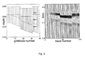
- FIG. 3 shows a 'truth-case' cross-section of the 40x1 comerpoint grid with seismic.
- Fig. 3 is a truth-case faulted 3-layer shale/sand/shale wedge model, with the sand layer of about 70% N G .
- Fault-block segments (based on seismic 'interpretation' in the corner point grid are shown grayscale coded.
- the comerpoint grid is based on a 100 x 100m grid, but the seismic is sampled at 40m spacing, i.e. denser traces than grid blocks, which is a common situation.
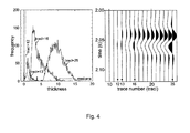
- Fig. 4 shows the histogram of the layer-2 thickness computed from exhaustive (5000 realisations) samples at four of the traces where the sand is thin. Note the evolution towards symmetric Gaussian-like distributions as the layer thickens.
- the median (50% quantile) statistic used in the analysis to define the most-likely value at each trace is highlighted on the axis.
- the layer depths extracted from the p50 statistics at each seismic trace lack spatial continuity for two reasons: 1) noise in the seismic traces feeding the inversion, and 2) sampling error in the MCMC ensemble, which will usually scale like N -1 / 2 if the ensemble has N samples, but may central limit more slowly if the posterior contains many modes and/or the modes have eccentric shapes (like pinchouts, which are 'half-Gaussians').
- the example above with only 100 realisations, can be expected to have substantial sampling noise (in practice, more realisations would be generated to reduce this).
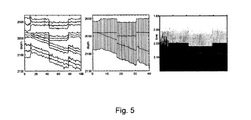
- Fig. 5 shows what the median model extracted from these samples will look like in both time and depth, and demonstrates the issues involved in forming a cornerpoint model from undersampled inversion with no smoothing.
- Fig. 5 shows what the median model extracted from these samples will look like in both time and depth, and demonstrates the issues involved in forming a cornerpoint model from undersampled inversion with no smoothing.
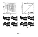
- Fig. 6 shows: (a) Cross section of most likely smoothed corner point model, with segments grayscale-coded; (b) p50 thickness and thickness uncertainty of middle layer, showing the effect of a single well observation in the 10th gridblock; (c) Four typical model realisations, with N G grayscale scale between dark (shale) and sand (light) - thickness and net-sand are continuous across faults; (d) Same as (c), but with continuity of layer thicknesses, etc, not enforced across the faults.
- the second example relates to the Stybarrow field off Western Australia, which has been subjected to the full gamut of Delivery style workflow.
- the field is an early Cretaceous turbidite sandstone, whose structure comprises a narrow, wedge-like NE-to-SW tilted fault block, with normal faults providing closure to the SW.
- Cross-section and elevation views are in Fig. 7, with the elevation in the down-dip direction along the line passing through the four wells.
- the coarse layer-based model constructed for Delivery inversion comprised 6 layers in the sequence shale/thin-sand/thin-shale/main-sand/hard-shale/shale.
- the seismic inversion was run only on traces within the fault block/hydrocarbon trap region.
- the asset geological team built an ECLIPSE model of the reservoir using the same layering, identifying about a dozen internal faults and associated segments.
- Fig. 8 shows grayscale maps of the p50 net-sand of the main sand, with obvious short-scale transverse noise caused by sampling error and various other sources of noise.
- Fig. 8(a) shows the map directly from Delivery inversion
- Fig. 8(b) shows the map after massaging with long-scale smoothing variograms in accordance with a preferred embodiment of the invention. The map smooths across segments since the faulting is treated as normal.
- the uncertainties in the main sand net-sand volume is strongly influenced by the correlation lengths of the allowable body fluctuations, as the extent to which the stochastic volumes will central-limit (within the fault-block integration area) to a sharply defined average is strongly controlled by these lengths.
- the distribution of this volume was estimated by drawing an ensemble of realisations of net-sand, conditioned on well data, and integrating over the maps above the contact level.
- the code produces ascii files with summary statistics of 200 realisations by using the typical runtime command:
- Fig. 9 shows typical realisations of the reservoir main sand body generated in this way, conditional on the well data and the seismic inversion constraints, (a) in plan view, and (c) in elevation.
- the inset Fig.9(b) shows the CDF of the net-sand volume computed from these realisations, with arbitrary units, with the effect of shortening the transverse correlation lengths demonstrated with a second curve.
- Correlation lengths used in the actual model were on the km scale, leading to much greater volumetric uncertainty than that obtained with short correlation scales. With the shorter fluctuation lengths, the overall integrated volume is naturally less uncertain, with a sharper rise in the CDF.
- the variogram structures do not affect the median volumetric statistics, as expected, since this is only a function of the smoothing algorithm.
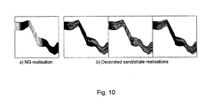
- Fig. 10 shows typical 'decorated' layer images generated using the preferred 'decoration' algorithms described above, along the same transect shown in Fig. 9(c), where the net-to-gross is quite high.
- the code produces a user-specified number of decorations for each NG realisation of the coarser layer.
- the sub-gridding uses proportional gridding, with variogram distances measured in the proportional sense within the layer.
- the method and deliveryMassager computer program according to the invention is an essential tool for coercing the stochastic seismic outputs from a stochastic seismic inversion, such as the Delivery seismic inversion tool to formats suitable for flow simulation or further 3D modelling and analysis. It performs a merging of expert-prescribed lateral correlations with the vertical correlations inferred in the inversion, which is essential for the generation of both realistic most-likely-case models and for uncertainty studies using stochastic realisations. Hard observations, faulting information, and segmentation requirement are honoured.
- the invention preferably generates industry-standard cornerpoint grid formats usable directly by common 3D modelling tools and flow simulators.
Landscapes
- Physics & Mathematics (AREA)
- Life Sciences & Earth Sciences (AREA)
- General Life Sciences & Earth Sciences (AREA)
- General Physics & Mathematics (AREA)
- Geophysics (AREA)
- Management, Administration, Business Operations System, And Electronic Commerce (AREA)
Applications Claiming Priority (1)
| Application Number | Priority Date | Filing Date | Title |
|---|---|---|---|
| US11/450,035 US7254091B1 (en) | 2006-06-08 | 2006-06-08 | Method for estimating and/or reducing uncertainty in reservoir models of potential petroleum reservoirs |
Publications (1)
| Publication Number | Publication Date |
|---|---|
| EP1865343A1 true EP1865343A1 (fr) | 2007-12-12 |
Family
ID=38324385
Family Applications (1)
| Application Number | Title | Priority Date | Filing Date |
|---|---|---|---|
| EP07252312A Withdrawn EP1865343A1 (fr) | 2006-06-08 | 2007-06-08 | Procédé d'estimation et/ou de réduction d'incertitudes dans des modèles de réservoirs potentiels de pétrole |
Country Status (2)
| Country | Link |
|---|---|
| US (1) | US7254091B1 (fr) |
| EP (1) | EP1865343A1 (fr) |
Cited By (16)
| Publication number | Priority date | Publication date | Assignee | Title |
|---|---|---|---|---|
| WO2012018428A1 (fr) | 2010-08-04 | 2012-02-09 | Exxonmobil Upstream Research Company | Système et procédé permettant de résumer des données dans une grille non structurée |
| WO2012174516A1 (fr) * | 2011-06-16 | 2012-12-20 | Schlumberger Canada Limited | Procédé de cartographie d'une formation souterraine sur la base de position de puits de forage et de données sismiques et système associé |
| CN103245972A (zh) * | 2012-02-07 | 2013-08-14 | 中国石油天然气集团公司 | 一种在二维空间内确定复杂地质构造的方法 |
| US8725481B2 (en) | 2007-12-13 | 2014-05-13 | Exxonmobil Upstream Research Company | Parallel adaptive data partitioning on a reservoir simulation using an unstructured grid |
| US8776895B2 (en) | 2006-03-02 | 2014-07-15 | Exxonmobil Upstream Research Company | Method for quantifying reservoir connectivity using fluid travel times |
| US8818780B2 (en) | 2008-11-14 | 2014-08-26 | Exxonmobil Upstream Research Company | Forming a model of a subsurface region |
| CN104316961A (zh) * | 2014-11-04 | 2015-01-28 | 中国石油集团川庆钻探工程有限公司地球物理勘探公司 | 获取风化层的地质参数的方法 |
| US9372943B2 (en) | 2008-05-05 | 2016-06-21 | Exxonmobil Upstream Research Company | Modeling dynamic systems by visualizing and narrowing a parameter space |
| US9470810B2 (en) | 2012-10-23 | 2016-10-18 | Halliburton Energy Services, Inc. | Data double-searching apparatus, methods, and systems |
| US9626466B2 (en) | 2010-11-23 | 2017-04-18 | Exxonmobil Upstream Research Company | Variable discretization method for flow simulation on complex geological models |
| US9753180B2 (en) | 2012-03-28 | 2017-09-05 | Exxonmobil Upstream Research Company | Method for multiphase flow upscaling |
| CN109116428A (zh) * | 2018-07-02 | 2019-01-01 | 中国石油天然气股份有限公司 | 一种缝洞型碳酸盐岩油藏不确定性建模方法及其装置 |
| US10319143B2 (en) | 2014-07-30 | 2019-06-11 | Exxonmobil Upstream Research Company | Volumetric grid generation in a domain with heterogeneous material properties |
| US10359523B2 (en) | 2014-08-05 | 2019-07-23 | Exxonmobil Upstream Research Company | Exploration and extraction method and system for hydrocarbons |
| CN110244363A (zh) * | 2018-03-09 | 2019-09-17 | 中国石油化工股份有限公司 | 一种用于预测缝洞型储集层资源量的方法 |
| CN110779566A (zh) * | 2018-07-13 | 2020-02-11 | 致伸科技股份有限公司 | 具有辅助判断功能的产品测试系统及产品测试辅助方法 |
Families Citing this family (81)
| Publication number | Priority date | Publication date | Assignee | Title |
|---|---|---|---|---|
| FR2918776B1 (fr) * | 2007-07-09 | 2009-09-25 | Total Sa | Procede, programme et systeme informatique de mise a l'echelle de donnees de modele de reservoir d'hydrocarbure. |
| FR2918777B1 (fr) | 2007-07-09 | 2009-09-25 | Total Sa | Procede, programme et systeme informatique de consiliation de donnees de modele de reservoir d'hydrocarbure. |
| US8055449B2 (en) * | 2007-10-08 | 2011-11-08 | Westerngeco L.L.C. | Determining fault transmissivity in a subterranean reservoir |
| EP2238474A4 (fr) | 2008-01-08 | 2018-06-20 | Exxonmobil Upstream Research Company | Inversion de forme spectrale et migration de données sismiques |
| US8285532B2 (en) * | 2008-03-14 | 2012-10-09 | Schlumberger Technology Corporation | Providing a simplified subterranean model |
| CN102007459B (zh) * | 2008-04-17 | 2015-01-07 | 埃克森美孚上游研究公司 | 用于储层开发计划的鲁棒性基于优化的决策支持工具 |
| CN102007485B (zh) * | 2008-04-18 | 2014-06-25 | 埃克森美孚上游研究公司 | 储层开发计划的基于markov决策过程的决策支持工具 |
| WO2009131761A2 (fr) * | 2008-04-21 | 2009-10-29 | Exxonmobile Upstream Research Company | Outil d’aide à la décision basé sur une programmation stochastique pour la planification de développement d’un réservoir |
| EP2406663A1 (fr) | 2009-03-13 | 2012-01-18 | Exxonmobil Upstream Research Company | Procédé de prédiction d'un écoulement de fluide |
| US8170288B2 (en) * | 2009-05-11 | 2012-05-01 | Saudi Arabian Oil Company | Reducing noise in 3D seismic data while preserving structural details |
| US9207351B2 (en) * | 2009-06-26 | 2015-12-08 | Exxonmobil Upstream Research Company | Constructing resistivity models from stochastic inversion |
| US20110131020A1 (en) * | 2009-09-09 | 2011-06-02 | Conocophillips Company | Dip guided full waveform inversion |
| US8930170B2 (en) * | 2009-11-18 | 2015-01-06 | Conocophillips Company | Attribute importance measure for parametric multivariate modeling |
| CA2776764A1 (fr) | 2009-11-30 | 2011-06-03 | Exxonmobil Upstream Research Company | Procede adaptatif de newton pour simulation de gisements |
| US8537638B2 (en) * | 2010-02-10 | 2013-09-17 | Exxonmobil Upstream Research Company | Methods for subsurface parameter estimation in full wavefield inversion and reverse-time migration |
| CA2791642C (fr) | 2010-04-06 | 2018-09-11 | Exxonmobil Upstream Research Company | Modelisation hierarchique de systemes physiques et leurs incertitudes |
| US8515720B2 (en) * | 2010-04-06 | 2013-08-20 | Schlumberger Technology Corporation | Determine field fractures using geomechanical forward modeling |
| US9134454B2 (en) | 2010-04-30 | 2015-09-15 | Exxonmobil Upstream Research Company | Method and system for finite volume simulation of flow |
| US8775142B2 (en) * | 2010-05-14 | 2014-07-08 | Conocophillips Company | Stochastic downscaling algorithm and applications to geological model downscaling |
| US8571842B2 (en) * | 2010-06-21 | 2013-10-29 | Schlumberger Technology Corporation | Method of determining parameter from sparse measurement data |
| AU2011283196B2 (en) | 2010-07-29 | 2014-07-31 | Exxonmobil Upstream Research Company | Method and system for reservoir modeling |
| CA2805446C (fr) | 2010-07-29 | 2016-08-16 | Exxonmobil Upstream Research Company | Procedes et systemes de simulation d'ecoulement basee sur un apprentissage machine |
| US10087721B2 (en) | 2010-07-29 | 2018-10-02 | Exxonmobil Upstream Research Company | Methods and systems for machine—learning based simulation of flow |
| BR112013002114A2 (pt) | 2010-09-20 | 2016-05-17 | Exxonmobil Upstream Res Co | formulações flexíveis e adaptáveis para simulações de reservatório complexas |
| US8942966B2 (en) | 2010-10-20 | 2015-01-27 | Conocophillips Company | Method for parameterizing and morphing stochastic reservoir models |
| BR112013012866A2 (pt) * | 2010-12-16 | 2016-09-06 | Landmark Graphics Corp | sistema de computador, método, e, meio legível por computador não transitório |
| US9046626B2 (en) | 2011-01-10 | 2015-06-02 | Westerngeco L.L.C. | Performing reverse time imaging of multicomponent acoustic and seismic data |
| US9026420B2 (en) * | 2011-01-13 | 2015-05-05 | Landmark Graphics Corporation | Method and system of updating a geocellular model |
| FR2972539B1 (fr) * | 2011-03-09 | 2013-04-26 | Total Sa | Procede informatique d'estimation, procede d'exploration et d'exploitation petroliere mettant en oeuvre un tel procede |
| US20120253681A1 (en) * | 2011-03-31 | 2012-10-04 | Chevron U.S.A. Inc. | System and method for processing seismic data |
| US9488047B2 (en) | 2011-04-04 | 2016-11-08 | Conocophillips Company | Reservoir calibration parameterization method |
| MX2013012009A (es) | 2011-04-15 | 2014-08-21 | Landmark Graphics Corp | Sistemas y metodos para caracterizacion de fracturas hidraulicas utilizando datos de movimientos microsismicos. |
| US20120296618A1 (en) * | 2011-05-20 | 2012-11-22 | Baker Hughes Incorporated | Multiscale Geologic Modeling of a Clastic Meander Belt Including Asymmetry Using Multi-Point Statistics |
| US20140043939A1 (en) * | 2011-05-24 | 2014-02-13 | Westerngeco L.L.C. | Imaging by extrapolation of vector-acoustic data |
| US8843353B2 (en) * | 2011-08-25 | 2014-09-23 | Chevron U.S.A. Inc. | Hybrid deterministic-geostatistical earth model |
| BR112014005794A2 (pt) | 2011-09-15 | 2017-03-28 | Exxonmobil Upstream Res Co | operações matriciais e vetoriais otimizadas em algoritmos de instrução limitada que executam cálculos de equação de estado |
| US10429537B2 (en) * | 2012-01-30 | 2019-10-01 | Schlumberger Technology Corporation | Efficiency of pixel-based inversion algorithms |
| MX340326B (es) | 2012-03-06 | 2016-07-05 | Ion Geophysical Corp | Modelo que predice la facturacion del esquisto. |
| US9002766B2 (en) * | 2012-08-31 | 2015-04-07 | Chevron U.S.A. Inc. | System and method for determining a value of information metric from a posterior distribution generated through stochastic inversion |
| EP2901363A4 (fr) | 2012-09-28 | 2016-06-01 | Exxonmobil Upstream Res Co | Suppression des failles dans des modèles géologiques |
| FR2998396B1 (fr) * | 2012-11-20 | 2015-01-16 | Total Sa | Procede pour evaluer une quantite d'hydrocarbures dans un gisement |
| FR2998397B1 (fr) * | 2012-11-20 | 2015-07-24 | Total Sa | Procede pour determiner une representation d'un reservoir d'hydrocarbures |
| US20140257700A1 (en) * | 2013-03-08 | 2014-09-11 | The Government Of The United States Of America, As Represented By The Secretary Of The Navy | System and method for estimating uncertainty for geophysical gridding routines lacking inherent uncertainty estimation |
| CN104251137A (zh) * | 2013-06-28 | 2014-12-31 | 中国石油化工股份有限公司 | 河流相厚油层层内夹层识别预测方法 |
| CN104346512A (zh) * | 2013-08-01 | 2015-02-11 | 安徽理工大学 | 基于gis的网格法煤炭资源/储量估算方法 |
| US20160327668A1 (en) * | 2014-01-14 | 2016-11-10 | Westerngeco Llc | Interferometry-bsed imaging and inversion |
| US10705250B2 (en) * | 2014-01-27 | 2020-07-07 | Schlumberger Technology Corporation | Generation of isotherm datasets for reservoir volumetric estimation |
| US10107938B2 (en) | 2014-10-31 | 2018-10-23 | Exxonmobil Upstream Research Company | Managing discontinuities in geologic models |
| CA2963092C (fr) | 2014-10-31 | 2021-07-06 | Exxonmobil Upstream Research Company | Procedes de gestion de discontinuite dans la construction d'espace de conception de modele de subsurface faillee a l'aide de moindres carres mobiles |
| US10803534B2 (en) | 2014-10-31 | 2020-10-13 | Exxonmobil Upstream Research Company | Handling domain discontinuity with the help of grid optimization techniques |
| US20160146972A1 (en) * | 2014-11-25 | 2016-05-26 | Conocophillips Company | Bayesian Updating Method Accounting for Non-Linearity Between Primary and Secondary Data |
| US10055884B2 (en) * | 2015-04-30 | 2018-08-21 | Saudi Arabian Oil Company | Three-dimensional fluid micromodels |
| US10678967B2 (en) * | 2016-10-21 | 2020-06-09 | International Business Machines Corporation | Adaptive resource reservoir development |
| WO2018118374A1 (fr) | 2016-12-23 | 2018-06-28 | Exxonmobil Upstream Research Company | Procédé et système de simulation de réservoir stable et efficace à l'aide d'indicateurs de stabilité |
| US10816684B2 (en) | 2017-02-02 | 2020-10-27 | Exxonmobil Upstream Research Company | Method for rapid calibration of seismic interval attributes to rock properties for assessment uncertainty |
| AU2018297693A1 (en) * | 2017-07-06 | 2019-12-12 | Chevron U.S.A. Inc. | System and method for full waveform inversion of seismic data |
| CA3072107C (fr) | 2017-09-28 | 2022-08-30 | Chevron U.S.A. Inc. | Systemes et procedes d'estimation de la productivite d'un reservoir en fonction de la profondeur dans un volume souterrain d'interet |
| CA3076523C (fr) * | 2017-09-28 | 2023-04-04 | Chevron, U.S.A. | Systemes et procedes d'estimation d'une probabilite de productivite de reservoir en fonction de la position dans un volume souterrain d'interet |
| US11423197B2 (en) | 2017-09-28 | 2022-08-23 | Chevron U.S.A. Inc. | Systems and methods for estimating a well design reservoir productivity as a function of position in a subsurface volume of interest based on a reservoir productivity parameter |
| CA3076522C (fr) | 2017-09-28 | 2023-08-22 | Chevron U.S.A. Inc. | Systemes et procedes d'estimation de la productivite de reservoir en fonction de la position dans un volume souterrain d'interet |
| US11914671B2 (en) | 2018-10-01 | 2024-02-27 | International Business Machines Corporation | Performing uncertainty quantification analysis with efficient two dimensional random fields |
| CN111474577B (zh) * | 2019-01-24 | 2023-07-25 | 中国石油天然气股份有限公司 | 扇形三角洲前缘沉积储层构型边界类型的确定方法及装置 |
| CA3131518C (fr) * | 2019-03-01 | 2023-10-17 | Bp Corporation North America Inc. | Inversion sismique stochastique iterative |
| CN109799531B (zh) * | 2019-03-20 | 2022-04-01 | 成都理工大学 | 一种基于地震分频相干属性的裂缝储层预测方法 |
| US11371336B2 (en) | 2019-09-19 | 2022-06-28 | Chevron U.S.A. Inc. | Systems and methods for estimating refined reservoir productivity values as a function of position in a subsurface volume of interest |
| US11480709B2 (en) | 2019-10-21 | 2022-10-25 | Chevron U.S.A. Inc. | Systems and methods for predicting hydrocarbon production and assessing prediction uncertainty |
| CN112782756B (zh) * | 2019-11-08 | 2024-06-25 | 中国石油天然气集团有限公司 | 一种基于自适应构造约束的约束层速度反演方法及系统 |
| CN111177646B (zh) * | 2019-12-30 | 2023-07-28 | 武汉市陆刻科技有限公司 | 一种岩溶含水层渗透场反演优化方法 |
| CN111273348B (zh) | 2020-01-21 | 2021-02-05 | 长江大学 | 基于更新概率比率恒定理论的多点地质统计叠前反演方法 |
| CN111444572B (zh) * | 2020-04-30 | 2023-10-31 | 石家庄学院 | 一种三维地质模型创建方法、共享方法及创建装置 |
| CN113589367B (zh) * | 2020-04-30 | 2023-04-28 | 中国石油化工股份有限公司 | 基于面积守恒大断裂附近构造趋势矫正方法 |
| US11286232B2 (en) | 2020-07-29 | 2022-03-29 | Saudi Arabian Oil Company | Preparation of cationic surfactants |
| US11820842B2 (en) | 2020-09-09 | 2023-11-21 | Saudi Arabian Oil Company | Sulfonated polymer |
| CN113159321B (zh) * | 2021-04-07 | 2022-05-20 | 中南大学 | 重力约束下断裂面形态的贝叶斯推断方法 |
| CN115221741B (zh) * | 2021-04-20 | 2025-11-28 | 中国石油化工股份有限公司 | 构建天然气水合物储层丘状形态框架模型的方法和系统 |
| CN115993646B (zh) * | 2021-10-20 | 2025-12-19 | 中国石油化工股份有限公司 | 井震联合油藏储层预测方法、装置及电子设备 |
| CN113960660B (zh) * | 2021-10-21 | 2022-09-16 | 成都理工大学 | 一种基于正演模拟的动校正畸变区域自动识别及切除方法 |
| CN114004104B (zh) * | 2021-11-09 | 2024-06-07 | 中铁第一勘察设计院集团有限公司 | 基于棋盘格测试的cors站点选取方法 |
| US20230252202A1 (en) * | 2022-02-09 | 2023-08-10 | Saudi Arabian Oil Company | Quantification of expressive experimental semi-variogram ranges uncertainties |
| CN119716974B (zh) * | 2023-09-27 | 2026-04-03 | 中国石油天然气股份有限公司 | 一种三维砂岩概率体的建立方法及装置 |
| CN120143248B (zh) * | 2023-12-12 | 2026-01-06 | 中国石油化工股份有限公司 | 一种基于平衡剖面定量描述断层反转过程方法 |
Citations (2)
| Publication number | Priority date | Publication date | Assignee | Title |
|---|---|---|---|---|
| US20030028325A1 (en) * | 2001-04-19 | 2003-02-06 | Frederic Roggero | Method of constraining by dynamic production data a fine model representative of the distribution in the reservoir of a physical quantity characteristic of the subsoil structure |
| US20060058965A1 (en) * | 2004-09-16 | 2006-03-16 | Ludovic Ricard | Method for generating a reservoir model on flexible grid |
Family Cites Families (2)
| Publication number | Priority date | Publication date | Assignee | Title |
|---|---|---|---|---|
| US5586066A (en) * | 1994-06-08 | 1996-12-17 | Arch Development Corporation | Surveillance of industrial processes with correlated parameters |
| FR2869421B1 (fr) * | 2004-04-27 | 2006-06-02 | Inst Francais Du Petrole | Methode de reconstruction d'un modele stochastique, representatif d'un milieu heterogene poreux, pour ameliorer son calage par les donnees de production |
-
2006
- 2006-06-08 US US11/450,035 patent/US7254091B1/en active Active
-
2007
- 2007-06-08 EP EP07252312A patent/EP1865343A1/fr not_active Withdrawn
Patent Citations (2)
| Publication number | Priority date | Publication date | Assignee | Title |
|---|---|---|---|---|
| US20030028325A1 (en) * | 2001-04-19 | 2003-02-06 | Frederic Roggero | Method of constraining by dynamic production data a fine model representative of the distribution in the reservoir of a physical quantity characteristic of the subsoil structure |
| US20060058965A1 (en) * | 2004-09-16 | 2006-03-16 | Ludovic Ricard | Method for generating a reservoir model on flexible grid |
Non-Patent Citations (3)
| Title |
|---|
| DURLOFSKY L. ET AL: "Scale up of heterogeneous three dimensional reservoir descriptions", SPE ANNUAL TECHNICAL CONFERENCE AND EXHIBITION, no. 30709, 22 October 1995 (1995-10-22), pages 313 - 326, XP002186719 * |
| GLINSKY, GUNNING ET AL.: "Integration of uncertain subsurface information into multiple reservoir simulation models", THE LEADING EDGE, October 2005 (2005-10-01), pages 990 - 999, XP002453182 * |
| TRAN T. T. ET AL: "Efficient conditioning of 3D fine-scale reservoir model to multiphase production data using streamline-based coarse-scale inversion and geostatistical downscaling", SPE ANNUAL TECHNICAL CONFERENCE AND EXHIBITION, no. 56518, 3 October 1999 (1999-10-03), pages 1 - 13, XP002186718 * |
Cited By (22)
| Publication number | Priority date | Publication date | Assignee | Title |
|---|---|---|---|---|
| US8776895B2 (en) | 2006-03-02 | 2014-07-15 | Exxonmobil Upstream Research Company | Method for quantifying reservoir connectivity using fluid travel times |
| US8725481B2 (en) | 2007-12-13 | 2014-05-13 | Exxonmobil Upstream Research Company | Parallel adaptive data partitioning on a reservoir simulation using an unstructured grid |
| US9372943B2 (en) | 2008-05-05 | 2016-06-21 | Exxonmobil Upstream Research Company | Modeling dynamic systems by visualizing and narrowing a parameter space |
| US8818780B2 (en) | 2008-11-14 | 2014-08-26 | Exxonmobil Upstream Research Company | Forming a model of a subsurface region |
| US9123161B2 (en) | 2010-08-04 | 2015-09-01 | Exxonmobil Upstream Research Company | System and method for summarizing data on an unstructured grid |
| WO2012018428A1 (fr) | 2010-08-04 | 2012-02-09 | Exxonmobil Upstream Research Company | Système et procédé permettant de résumer des données dans une grille non structurée |
| US9626466B2 (en) | 2010-11-23 | 2017-04-18 | Exxonmobil Upstream Research Company | Variable discretization method for flow simulation on complex geological models |
| WO2012174516A1 (fr) * | 2011-06-16 | 2012-12-20 | Schlumberger Canada Limited | Procédé de cartographie d'une formation souterraine sur la base de position de puits de forage et de données sismiques et système associé |
| CN103245972A (zh) * | 2012-02-07 | 2013-08-14 | 中国石油天然气集团公司 | 一种在二维空间内确定复杂地质构造的方法 |
| CN103245972B (zh) * | 2012-02-07 | 2016-06-08 | 中国石油天然气集团公司 | 一种在二维空间内确定复杂地质构造的方法 |
| US9753180B2 (en) | 2012-03-28 | 2017-09-05 | Exxonmobil Upstream Research Company | Method for multiphase flow upscaling |
| US9470810B2 (en) | 2012-10-23 | 2016-10-18 | Halliburton Energy Services, Inc. | Data double-searching apparatus, methods, and systems |
| US10319143B2 (en) | 2014-07-30 | 2019-06-11 | Exxonmobil Upstream Research Company | Volumetric grid generation in a domain with heterogeneous material properties |
| US10359523B2 (en) | 2014-08-05 | 2019-07-23 | Exxonmobil Upstream Research Company | Exploration and extraction method and system for hydrocarbons |
| CN104316961B (zh) * | 2014-11-04 | 2017-04-19 | 中国石油集团川庆钻探工程有限公司地球物理勘探公司 | 获取风化层的地质参数的方法 |
| CN104316961A (zh) * | 2014-11-04 | 2015-01-28 | 中国石油集团川庆钻探工程有限公司地球物理勘探公司 | 获取风化层的地质参数的方法 |
| CN110244363A (zh) * | 2018-03-09 | 2019-09-17 | 中国石油化工股份有限公司 | 一种用于预测缝洞型储集层资源量的方法 |
| CN110244363B (zh) * | 2018-03-09 | 2020-10-23 | 中国石油化工股份有限公司 | 一种用于预测缝洞型储集层资源量的方法 |
| CN109116428A (zh) * | 2018-07-02 | 2019-01-01 | 中国石油天然气股份有限公司 | 一种缝洞型碳酸盐岩油藏不确定性建模方法及其装置 |
| CN109116428B (zh) * | 2018-07-02 | 2020-06-09 | 中国石油天然气股份有限公司 | 一种缝洞型碳酸盐岩油藏不确定性建模方法及其装置 |
| CN110779566A (zh) * | 2018-07-13 | 2020-02-11 | 致伸科技股份有限公司 | 具有辅助判断功能的产品测试系统及产品测试辅助方法 |
| CN110779566B (zh) * | 2018-07-13 | 2021-09-28 | 致伸科技股份有限公司 | 具有辅助判断功能的产品测试系统及产品测试辅助方法 |
Also Published As
| Publication number | Publication date |
|---|---|
| US7254091B1 (en) | 2007-08-07 |
Similar Documents
| Publication | Publication Date | Title |
|---|---|---|
| EP1865343A1 (fr) | Procédé d'estimation et/ou de réduction d'incertitudes dans des modèles de réservoirs potentiels de pétrole | |
| Dubrule | Geostatistics in petroleum geology | |
| EP3548929B1 (fr) | Procédé d'estimation de propriétés pétrophysiques pour des scénarios simples ou multiples à partir de plusieurs produits d'inversion de champ d'onde sismique et de champ d'onde complet spectralement variables | |
| Holden et al. | Modeling of fluvial reservoirs with object models | |
| US7844430B2 (en) | Reservoir model building methods | |
| Mariethoz et al. | Reconstruction of incomplete data sets or images using direct sampling | |
| US10578767B2 (en) | Conditional process-aided multiple-points statistics modeling | |
| Caers et al. | The probability perturbation method: A new look at Bayesian inverse modeling | |
| US8452580B2 (en) | Method and system for using multiple-point statistics simulation to model reservoir property trends | |
| CN102918423B (zh) | 用于地震烃体系分析的方法 | |
| EP2422222B1 (fr) | Procédé de prédiction d'un écoulement de fluide | |
| US11409023B2 (en) | Methods to handle discontinuity in constructing design space using moving least squares | |
| US20170038489A1 (en) | Fracture-Size-Correlated Aperture Mapping for Localized Porosity and Permeability Determination | |
| Karssenberg et al. | Conditioning a process-based model of sedimentary architecture to well data | |
| Cao et al. | Geostatistical applications in petroleum reservoir modelling | |
| Caers et al. | Geostatistical quantification of geological information for a fluvial-type North Sea reservoir | |
| Pan et al. | Hierarchical machine learning workflow for conditional and multiscale deep-water reservoir modeling | |
| Dawuda et al. | Geologic modeling and ensemble-based history matching for evaluating co2 sequestration potential in point bar reservoirs | |
| Rowbotham et al. | Multidisciplinary stochastic impedance inversion: integrating geological understanding and capturing reservoir uncertainty | |
| US20210405250A1 (en) | Conditioning of Surface-Based Geologic Models | |
| Gunning et al. | Delivery Massager: A tool for propagating seismic inversion information into reservoir models | |
| Hu et al. | Elements for an integrated geostatistical modeling of heterogeneous reservoirs | |
| Beucher et al. | Using 3D seismic-derived information in lithofacies simulations. A case study | |
| Yao | Integrating seismic data for lithofacies modeling: A comparison of sequential indicator simulation algorithms | |
| Peter et al. | Improved lithology prediction in channelized reservoirs by integrating stratigraphic forward modelling: Towards improved model calibration in a case study of the Holocene Rhine-Meuse fluvio-deltaic system |
Legal Events
| Date | Code | Title | Description |
|---|---|---|---|
| PUAI | Public reference made under article 153(3) epc to a published international application that has entered the european phase |
Free format text: ORIGINAL CODE: 0009012 |
|
| AK | Designated contracting states |
Kind code of ref document: A1 Designated state(s): AT BE BG CH CY CZ DE DK EE ES FI FR GB GR HU IE IS IT LI LT LU LV MC MT NL PL PT RO SE SI SK TR |
|
| AX | Request for extension of the european patent |
Extension state: AL BA HR MK YU |
|
| 17P | Request for examination filed |
Effective date: 20080609 |
|
| 17Q | First examination report despatched |
Effective date: 20080715 |
|
| AKX | Designation fees paid |
Designated state(s): AT BE BG CH CY CZ DE DK EE ES FI FR GB GR HU IE IS IT LI LT LU LV MC MT NL PL PT RO SE SI SK TR |
|
| GRAP | Despatch of communication of intention to grant a patent |
Free format text: ORIGINAL CODE: EPIDOSNIGR1 |
|
| STAA | Information on the status of an ep patent application or granted ep patent |
Free format text: STATUS: THE APPLICATION IS DEEMED TO BE WITHDRAWN |
|
| 18D | Application deemed to be withdrawn |
Effective date: 20111130 |