EP1939837A2 - Compression sans perte de données géographiques en temps réel - Google Patents
Compression sans perte de données géographiques en temps réel Download PDFInfo
- Publication number
- EP1939837A2 EP1939837A2 EP07122896A EP07122896A EP1939837A2 EP 1939837 A2 EP1939837 A2 EP 1939837A2 EP 07122896 A EP07122896 A EP 07122896A EP 07122896 A EP07122896 A EP 07122896A EP 1939837 A2 EP1939837 A2 EP 1939837A2
- Authority
- EP
- European Patent Office
- Prior art keywords
- data
- gis
- data points
- gis data
- points
- Prior art date
- Legal status (The legal status is an assumption and is not a legal conclusion. Google has not performed a legal analysis and makes no representation as to the accuracy of the status listed.)
- Withdrawn
Links
- 238000007906 compression Methods 0.000 title description 5
- 230000006835 compression Effects 0.000 title description 5
- 238000000034 method Methods 0.000 claims abstract description 23
- 230000004044 response Effects 0.000 claims abstract description 10
- 230000001131 transforming effect Effects 0.000 claims 4
- 230000009466 transformation Effects 0.000 abstract description 10
- 238000013144 data compression Methods 0.000 description 9
- 230000005540 biological transmission Effects 0.000 description 8
- 230000008569 process Effects 0.000 description 3
- 238000006467 substitution reaction Methods 0.000 description 3
- 230000008859 change Effects 0.000 description 2
- 238000012986 modification Methods 0.000 description 2
- 230000004048 modification Effects 0.000 description 2
- 230000009467 reduction Effects 0.000 description 2
- 238000009877 rendering Methods 0.000 description 2
- 238000010276 construction Methods 0.000 description 1
- 230000001186 cumulative effect Effects 0.000 description 1
- 230000006837 decompression Effects 0.000 description 1
- 230000000694 effects Effects 0.000 description 1
- 238000005457 optimization Methods 0.000 description 1
- 238000011084 recovery Methods 0.000 description 1
Images




Classifications
-
- G—PHYSICS
- G09—EDUCATION; CRYPTOGRAPHY; DISPLAY; ADVERTISING; SEALS
- G09B—EDUCATIONAL OR DEMONSTRATION APPLIANCES; APPLIANCES FOR TEACHING, OR COMMUNICATING WITH, THE BLIND, DEAF OR MUTE; MODELS; PLANETARIA; GLOBES; MAPS; DIAGRAMS
- G09B29/00—Maps; Plans; Charts; Diagrams, e.g. route diagram
-
- H—ELECTRICITY
- H03—ELECTRONIC CIRCUITRY
- H03M—CODING; DECODING; CODE CONVERSION IN GENERAL
- H03M7/00—Conversion of a code where information is represented by a given sequence or number of digits to a code where the same, similar or subset of information is represented by a different sequence or number of digits
- H03M7/30—Compression; Expansion; Suppression of unnecessary data, e.g. redundancy reduction
Definitions
- aspects described herein relate to a method for efficient compression of geographic coordinate data that permits lossless decompression and recovery of the data with little or no computational overhead.
- geographic information services (commonly known as geographic information services (GIS) data) enable users to enter an address and retrieve a map showing the requested address and surrounding area.
- GIS geographic information services
- the geographic data in the database consists of latitude/longitude pairs or, in a three-dimensional system, tuples comprising latitude, longitude, and elevation coordinates.
- This coordinate data can be used to form a point representing a specific location; a line representing, for example, a street or a range of specific locations; or a polygon representing a larger area.
- This data is often transmitted over a client-server or a multi-tiered architecture and, for detailed views, can consume enormous bandwidth.
- multiuser GIS data servers can be required to process and return map data at a rate of 1GB/second or even higher.
- GIS data are retrieved by use of mobile devices such as web-enabled cell phones or portable computers.
- computer-based navigation systems such as those based on Global Positioning System (GPS) software have rapidly proliferated, and are now commonplace components in automobiles or in stand-alone portable devices.
- GPS Global Positioning System
- Such computer systems may have relatively limited computer resources such as limited memory and relatively slow input/output.
- the bandwidth limitations of devices used to request and receive GIS data combined with the bandwidth requirements involved in generating and returning the requested GIS data to the requestor, make compression of the data stream flowing from the GIS data server to the user highly desirable. For example, data compression can reduce the memory required to receive and process GIS data, and thus significantly can improve performance. In addition, in cases where bandwidth is purchased, data compression can reduce the bandwidth needed and thus result in cost savings.
- one method of compressing data from a geographic database involves searching a data stream for a plurality of data characters that matches a plurality of data characters at a first position in the string and then replacing those matching characters with a substitution code, i.e., a reference to the characters at the first position.
- the data are decompressed by reversing the process, i.e., by searching through the compressed data stream and replacing the substitution codes with sub-strings of the appropriate data.
- This method require significant computational time, and thus are unsuitable for real-time demand-based applications.
- a method for encoding GIS data which uses the latitude/longitude coordinates of one point as a reference point and transforms the coordinates of the other points of interest into relative values based on the reference point and a scaling factor.
- the substitution of relative values for absolute values results in the use of significantly fewer bytes of data to render the information.
- the original data points can be retrieved by a simple reverse transformation, requiring only a trivial amount of computational overhead. In some cases, no reverse transformation may be needed, as the compressed data can be directly utilized by the client application.
- FIG. 1 depicts a display of a query page for a GIS database as known in the art.
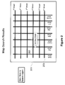
- FIG. 2 depicts a display of the results of a query from a GIS database as is known in the art.
- FIG. 3 depicts a display of the results of a query from a GIS database showing latitude/longitude coordinates as is known in the art.
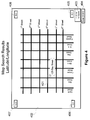
- FIG. 4 depicts a result from a coordinate transformation according to one or more aspects described herein.
- FIG. 5 depicts elements of a system that can be used to generate and output a display of results from a coordinate transformation according to one or more aspects described herein.
- FIG. 6 depicts a logic flow that can be used by a processor to generate and output compressed GIS data according to one or more aspects described herein.
- GIS data is provided, such as in the context of a client application automatically requesting GIS data without user input or in the context of providing geographic information to locate objects based on GPS signals.
- FIG. 1 shows a typical query page for a GIS database as known in the art.
- a query page can permit a user to enter information regarding a desired location on a map (101), such as an address (102), ZIP code (103), or city and state (104) and obtain a map showing the requested location.
- the map that is returned may vary depending on the nature of the search and the parameters of the navigation database software used. For example, if a user enters a street address, the database may return a map such as is shown in FIG. 2 , which displays a rectangular area (201), the requested address (202), and an area (203) surrounding the requested address.
- map generation software will draw the map based on the latitude and longitude values of the geographic features therein, and will transmit those values to define the map generated in response to a user's query.
- this raw coordinate data is encoded as a binary floating-point or fixed-point value. Depending on the accuracy needed for a given map, this requires 4, 8, or even 12 bytes of data per value.
- a latitude/longitude point requires two such values, one for each of the latitude value and the longitude value, and thus requires 8 to 12 bytes of data.
- Some implementations are even more inefficient, transmitting the data as a text representation requiring up to 30 bytes per point. Since a map may contain several hundred data points, rendering even a simple map may require many megabits of data.
- a latitude/longitude pair represents an absolute point anywhere on the earth's surface.
- the latitude/longitude pair [38.889 N, -077.036 W] gives the location of the Washington Monument in Washington, D.C.
- any map depicting the Washington Monument or even a larger surrounding area of Washington, D.C. is typically a very small fraction of the earth's surface, often a few square kilometers or less. If the coordinates of objects within that map were given relative to the view shown in the map rather than in absolute terms, the domain of the data needed can drop, often by as much as several orders of magnitude.
- a map of a specified location and the surrounding area can be defined by the latitude/longitude points for points on the perimeter such as the four corners of a square.
- these four corners can be described not by their absolute latitude and longitude values but instead by relative values based on their distance from some fixed point.
- the relative values can require significantly fewer bytes of data per point and thus need significantly less memory to store and less bandwidth to transmit.
- the dataset of relative values can be transmitted to the client application together with an initial absolute reference point and a scaling factor used to transform the absolute values to relative ones.
- the client application can then reconstruct the original dataset from the reference point, relative values and scaling factor, using a simple arithmetic transformation requiring only a trivial amount of computational overhead.
- the result is reconstruction of the original dataset at the client with a significantly reduced need for memory and bandwidth during transmission from the server.
- no reverse transformation may be needed, as the compressed data can be directly utilized by the client application, such as where the scaling factor maps directly into a client viewspace.
- FIG. 3 shows a map (301) drawn in response to a query for an address (302) as shown in FIG. 1 .
- the returned map depicts a portion of the earth comprising a square represented by the following latitude/longitude values: [41.01N, -74.583W] (303); [41.01N, -74.588W] (304); [41.06N, -74.588W] (305); and [41.06N, -74.583W] (306).
- transmitting this map would require transmission of data regarding four points, one for each corner of the square. Each point requires two values, one for each of the latitude and longitude. Thus, if each value requires 8 bytes of data, transmission of this map requires a total of 64 bytes of data.
- the data required to transmit such geographical information and render a map as shown in FIG. 2 can be significantly reduced by the use of relative rather than absolute values to describe one or more of the necessary data points.
- one point of a geographic area can be defined to be a base point.
- a scaling factor can be given to permit the translation of the absolute coordinates to relative coordinates, and in such a case, the other points can then be defined in terms of their values relative to that base point rather than in absolute values.
- relative values in accordance with aspects herein can be defined and transmitted by prefacing the data values with a tag representing a coordinates of a corner point and a relative scale factor, and using the corner point and the scale factor to define the points on the map.
- the values described in FIG. 3 can be defined and transmitted using a reference point, scaling factor, and relative data points as follows and as shown in FIG. 4 for a map (402) showing an address (401) requested by a client application: [Comer] [41.01N, - 74.583W] (403); [Scale] [0.001] (404); [0,0] (405); [0,5] (406); [50,5] (407); [50,0] (408).
- a corner point is given in terms of its absolute values, for example, in the exemplary illustration above, latitude/longitude values of [41.01N, -74.583W] (403).
- a scaling factor is given, and in the exemplary illustration has a value of [0.001] (404). All points needed to define the area, including the corner point, can then be given in terms of their values relative to the corner point based on the scaling factor.
- the corner point can be represented by "[0,0]" (405) because its coordinates have no change from the reference point.
- the next point can be represented by "[0,5]” (406) because its coordinates, [41.01N, -74.588W] (304), can be represented in terms of their values relative to the reference point in accordance with the scaling factor.
- the latitude value 41.01N is given a relative value "0" because it has no change from the reference point.
- the longitude value -74.588W is given a relative value "5" because its value is 5 x 0.001 (i.e., 5 x the scaling factor) from the reference point.
- the other points can similarly be expressed in terms of their values relative to the reference point in accordance with the scaling factor.
- Using a set of relative values such as those described above permits the use of low-precision 2-byte integers to describe the map rather than the 8-byte data values required by describing the map in absolute coordinates.
- the map described above would require eight 2-byte values for the relative points, for a total of 16 bytes, rather than 64 bytes, or only one-quarter of the original amount of data and resulting in an effective data compression ratio of 75%.
- the extra data overhead from transmitting the transformation tag is trivial. More significantly, only a single transformation tag consisting of a single reference point and scaling factor need be transmitted for a view consisting of hundreds or thousands of detailed objects, with the remaining objects being defined only in terms of their relative positions based on the reference point and scaling factor.
- Transmitting coordinate data in using relative values in accordance with one or more aspects described herein can result in significant space savings in the amount of data required to transmit geographic coordinate information, and can thus reduce the amount of bandwidth required to transmit such information. These space savings can also allow significantly faster transmission of geographic data in a client-server or multi-tiered software architecture. This can result in increased performance and, in cases where bandwidth is purchased, can result in significant cost savings as well.
- the use of a fixed point, scaling factor, and relative values in accordance with one or more aspects to transmit geographic data can allow the application to zoom and scale a view without distortion or inaccuracy, because the compression is fully lossless, and therefore there is no error or reduction in the data.
- most GIS systems progressively render more data as the image is zoomed in and the magnification level shrinks, and therefore, the benefits of a data compression method in accordance with one or more aspects described herein that transmits data using relative values can be especially realized where it is most needed, i.e., for high-resolution views of small areas.
- An encoding algorithm in accordance with one or more aspects described herein can also be combined with other data optimization methods known in the art, such as traditional data compression, node removal/interpolation, and accuracy reduction.
- data optimization methods known in the art, such as traditional data compression, node removal/interpolation, and accuracy reduction.
- the data-savings effects of such a combination can be cumulative and can work well with each other.
- compressed data produced in accordance with one or more aspects described herein can experience standard geometric and GIS operations directly without the data having to be decompressed.
- a GIS server can send compressed data to a middle-tier business rules broker. That broker can then operate directly on the data, performing operations such as intersection or union of two or more polygons representing a geographical area, without having to decompress the data.
- the broker can then send the resulting data, still in compressed form, to a remote client.
- the data can be created, transmitted, manipulated, and retransmitted, all in compressed form without having to be decompressed at any stage.
- raw GIS data can reside in a SQL (Structured Query Language) data store (501) well known in the art.
- the raw GIS data can be retrieved by a middleware component (502), which can be, for example, an ORB broker, a J2EE server, or a Corba or XML-based web service, or directly by a server (503), for example, a web server.
- a middleware component 502
- the compressed GIS data can be encapsulated within the data to be returned in response to a query, for example, over the Internet.
- the query response containing the encapsulated compressed GIS data can be sent using any standard data transmission protocol, for example, a standard HTTP protocol in the case of an Internet-based application, to a LAN, a WAN, or the Internet (504), and from there sent, again using any standard data transmission protocol, to a client application (505), where the compressed GIS data can be decompressed and displayed to a user.
- the client application can reside on any device that can receive data, such as a PC, a laptop computer, a handheld computer, or a computer in a mobile setting, such as a GPS system residing in an automobile.
- FIG. 6 depicts a logic flow that can be used by a processor to generate and store compressed data representing GIS data points in accordance with one or more aspects.
- the processor receives a request for GIS data, for example, in the form of query for GIS data point representing a specific address.
- the processor searches the database and retrieves GIS database responsive to the query.
- the processor obtains GIS data points defining an area surrounding the requested GIS data point, and at step (604) the processor draws a map of the requested GIS data point and the surrounding area based on the retrieved data points.
- the processor sets one GIS data point as a reference point to be used to generate relative data points in accordance with one or more aspects herein.
- the processor sets the scaling factor to be used to generate the relative data points.
- the processor uses the reference point set at step (605) and the scaling factor set at step (606), the processor transforms all data points in the map from absolute to relative values based on the reference point and scaling factor.
- the processor returns an answer to the query by outputting data identifying the reference point, the scaling factor, and the transformed data points defining the requested map and the surrounding area.
Landscapes
- Engineering & Computer Science (AREA)
- Theoretical Computer Science (AREA)
- Physics & Mathematics (AREA)
- Mathematical Physics (AREA)
- Business, Economics & Management (AREA)
- Educational Administration (AREA)
- Educational Technology (AREA)
- General Physics & Mathematics (AREA)
- Instructional Devices (AREA)
- Compression, Expansion, Code Conversion, And Decoders (AREA)
- Information Retrieval, Db Structures And Fs Structures Therefor (AREA)
- Processing Or Creating Images (AREA)
Applications Claiming Priority (1)
| Application Number | Priority Date | Filing Date | Title |
|---|---|---|---|
| US61363006A | 2006-12-20 | 2006-12-20 |
Publications (2)
| Publication Number | Publication Date |
|---|---|
| EP1939837A2 true EP1939837A2 (fr) | 2008-07-02 |
| EP1939837A3 EP1939837A3 (fr) | 2010-04-28 |
Family
ID=39149301
Family Applications (1)
| Application Number | Title | Priority Date | Filing Date |
|---|---|---|---|
| EP07122896A Withdrawn EP1939837A3 (fr) | 2006-12-20 | 2007-12-11 | Compression sans perte de données géographiques en temps réel |
Country Status (2)
| Country | Link |
|---|---|
| EP (1) | EP1939837A3 (fr) |
| JP (1) | JP2008186446A (fr) |
Cited By (8)
| Publication number | Priority date | Publication date | Assignee | Title |
|---|---|---|---|---|
| CN103064836A (zh) * | 2011-10-18 | 2013-04-24 | 天眼卫星科技有限公司 | 图像文件的显示方法及群组管理方法 |
| CN103106281A (zh) * | 2013-02-22 | 2013-05-15 | 上海埃威航空电子有限公司 | 一种电子海图位置点数据简化方法和系统 |
| CN103927169A (zh) * | 2014-04-10 | 2014-07-16 | 南京信息工程大学 | 一种实现gdi+绘制电子地图放缩的方法 |
| CN105575254A (zh) * | 2014-11-11 | 2016-05-11 | 高德信息技术有限公司 | 电子地图道路渲染方法和装置 |
| US10359518B2 (en) * | 2016-12-30 | 2019-07-23 | DeepMap Inc. | Vector data encoding of high definition map data for autonomous vehicles |
| CN113505107A (zh) * | 2021-05-26 | 2021-10-15 | 中国再保险(集团)股份有限公司 | 一种台风文件压缩方法及压缩系统 |
| WO2024119565A1 (fr) * | 2022-12-08 | 2024-06-13 | 北星空间信息技术研究院(南京)有限公司 | Procédé et appareil de dessin de données vectorielles de système d'informations géographiques, et dispositif électronique |
| CN120086184A (zh) * | 2025-02-13 | 2025-06-03 | 中远海运散货运输有限公司 | 一种电子海图enc数据向senc数据转换的方法 |
Citations (1)
| Publication number | Priority date | Publication date | Assignee | Title |
|---|---|---|---|---|
| US6393149B2 (en) | 1998-09-17 | 2002-05-21 | Navigation Technologies Corp. | Method and system for compressing data and a geographic database formed therewith and methods for use thereof in a navigation application program |
Family Cites Families (2)
| Publication number | Priority date | Publication date | Assignee | Title |
|---|---|---|---|---|
| US6577769B1 (en) * | 1999-09-18 | 2003-06-10 | Wildtangent, Inc. | Data compression through adaptive data size reduction |
| US7308117B2 (en) * | 2000-02-04 | 2007-12-11 | National Science And Technology Development Agency | System and method for manipulating information and map for geographical resource management |
-
2007
- 2007-12-11 EP EP07122896A patent/EP1939837A3/fr not_active Withdrawn
- 2007-12-14 JP JP2007322746A patent/JP2008186446A/ja active Pending
Patent Citations (1)
| Publication number | Priority date | Publication date | Assignee | Title |
|---|---|---|---|---|
| US6393149B2 (en) | 1998-09-17 | 2002-05-21 | Navigation Technologies Corp. | Method and system for compressing data and a geographic database formed therewith and methods for use thereof in a navigation application program |
Cited By (16)
| Publication number | Priority date | Publication date | Assignee | Title |
|---|---|---|---|---|
| CN103064836A (zh) * | 2011-10-18 | 2013-04-24 | 天眼卫星科技有限公司 | 图像文件的显示方法及群组管理方法 |
| CN103106281A (zh) * | 2013-02-22 | 2013-05-15 | 上海埃威航空电子有限公司 | 一种电子海图位置点数据简化方法和系统 |
| CN103927169A (zh) * | 2014-04-10 | 2014-07-16 | 南京信息工程大学 | 一种实现gdi+绘制电子地图放缩的方法 |
| CN105575254B (zh) * | 2014-11-11 | 2019-10-22 | 高德信息技术有限公司 | 电子地图道路渲染方法和装置 |
| CN105575254A (zh) * | 2014-11-11 | 2016-05-11 | 高德信息技术有限公司 | 电子地图道路渲染方法和装置 |
| CN110869981B (zh) * | 2016-12-30 | 2023-12-01 | 辉达公司 | 用于自主车辆的高清晰度地图数据的向量数据编码 |
| US10401500B2 (en) | 2016-12-30 | 2019-09-03 | DeepMap Inc. | Encoding LiDAR scanned data for generating high definition maps for autonomous vehicles |
| CN110869981A (zh) * | 2016-12-30 | 2020-03-06 | 迪普迈普有限公司 | 用于自主车辆的高清晰度地图数据的向量数据编码 |
| US11209548B2 (en) * | 2016-12-30 | 2021-12-28 | Nvidia Corporation | Encoding lidar scanned data for generating high definition maps for autonomous vehicles |
| US11754716B2 (en) | 2016-12-30 | 2023-09-12 | Nvidia Corporation | Encoding LiDAR scanned data for generating high definition maps for autonomous vehicles |
| US10359518B2 (en) * | 2016-12-30 | 2019-07-23 | DeepMap Inc. | Vector data encoding of high definition map data for autonomous vehicles |
| US12092742B2 (en) | 2016-12-30 | 2024-09-17 | Nvidia Corporation | Encoding LiDAR scanned data for generating high definition maps for autonomous vehicles |
| CN113505107A (zh) * | 2021-05-26 | 2021-10-15 | 中国再保险(集团)股份有限公司 | 一种台风文件压缩方法及压缩系统 |
| CN113505107B (zh) * | 2021-05-26 | 2023-11-10 | 中国再保险(集团)股份有限公司 | 一种台风文件压缩方法及压缩系统 |
| WO2024119565A1 (fr) * | 2022-12-08 | 2024-06-13 | 北星空间信息技术研究院(南京)有限公司 | Procédé et appareil de dessin de données vectorielles de système d'informations géographiques, et dispositif électronique |
| CN120086184A (zh) * | 2025-02-13 | 2025-06-03 | 中远海运散货运输有限公司 | 一种电子海图enc数据向senc数据转换的方法 |
Also Published As
| Publication number | Publication date |
|---|---|
| EP1939837A3 (fr) | 2010-04-28 |
| JP2008186446A (ja) | 2008-08-14 |
Similar Documents
| Publication | Publication Date | Title |
|---|---|---|
| US7308117B2 (en) | System and method for manipulating information and map for geographical resource management | |
| EP1939837A2 (fr) | Compression sans perte de données géographiques en temps réel | |
| US6703947B1 (en) | Method for organizing and compressing spatial data | |
| US6931603B2 (en) | Method and system for appending information to graphical files stored in specific graphical file formats | |
| US8880589B2 (en) | Signature based map caching | |
| US20030231190A1 (en) | Methods and systems for downloading and viewing maps | |
| US6674445B1 (en) | Generalized, differentially encoded, indexed raster vector data and schema for maps on a personal digital assistant | |
| US7430340B2 (en) | Geographic information data base engine | |
| US7562289B2 (en) | Methods and systems for encoding geographic coordinates and features in a portable document format file | |
| KR101164719B1 (ko) | 효율적인 저장 및 전송을 위한 지리정보시스템의 벡터 맵 데이터 압축 방법 | |
| CN111274341A (zh) | 一种网点选址方法和装置 | |
| WO2007142507A1 (fr) | Système et procédé d'identification d'emplacements géographiques | |
| CN112733500A (zh) | 快速逆地理编码方法、装置及其电子设备 | |
| US20040119611A1 (en) | System and method for progressive spatial data service | |
| Xi et al. | Application of GML and SVG in the development of WebGIS | |
| Zhang et al. | Dynamic tiled map services: Supporting query-based visualization of large-scale raster geospatial data | |
| CN115994405B (zh) | 基于bim技术的城市信息管理平台构建方法 | |
| KR20040051266A (ko) | 클라이언트/서버 환경의 지리정보 제공 시스템 및 방법 | |
| Khoshgozaran et al. | A multi-resolution compression scheme for efficientwindow queries over road network databases | |
| TWI236803B (en) | Method of converting geospatial database into compressive database for multiple dimensional data storage | |
| Franti et al. | Dynamic use of map images in mobile environment | |
| Zhu et al. | Data Compression for Network GIS. | |
| Rishe et al. | TerraFly Geospatial System for Disaster Mitigation | |
| Davis-Chu et al. | A System for Continuous, Real-Time Search and Retrieval of Georeferenced Objects | |
| Li et al. | Progressive simplification and transmission of building polygons based on triangle meshes |
Legal Events
| Date | Code | Title | Description |
|---|---|---|---|
| PUAI | Public reference made under article 153(3) epc to a published international application that has entered the european phase |
Free format text: ORIGINAL CODE: 0009012 |
|
| AK | Designated contracting states |
Kind code of ref document: A2 Designated state(s): AT BE BG CH CY CZ DE DK EE ES FI FR GB GR HU IE IS IT LI LT LU LV MC MT NL PL PT RO SE SI SK TR |
|
| AX | Request for extension of the european patent |
Extension state: AL BA HR MK RS |
|
| PUAL | Search report despatched |
Free format text: ORIGINAL CODE: 0009013 |
|
| AK | Designated contracting states |
Kind code of ref document: A3 Designated state(s): AT BE BG CH CY CZ DE DK EE ES FI FR GB GR HU IE IS IT LI LT LU LV MC MT NL PL PT RO SE SI SK TR |
|
| AX | Request for extension of the european patent |
Extension state: AL BA HR MK RS |
|
| RIC1 | Information provided on ipc code assigned before grant |
Ipc: H03M 7/30 20060101ALI20100323BHEP Ipc: G01C 21/32 20060101ALI20100323BHEP Ipc: G09B 29/00 20060101AFI20080313BHEP |
|
| AKY | No designation fees paid | ||
| REG | Reference to a national code |
Ref country code: DE Ref legal event code: 8566 |
|
| STAA | Information on the status of an ep patent application or granted ep patent |
Free format text: STATUS: THE APPLICATION IS DEEMED TO BE WITHDRAWN |
|
| 18D | Application deemed to be withdrawn |
Effective date: 20101029 |