EP1969317B1 - Verfahren und systeme zum anzeigen von beweglichen karten auf der route - Google Patents
Verfahren und systeme zum anzeigen von beweglichen karten auf der route Download PDFInfo
- Publication number
- EP1969317B1 EP1969317B1 EP06848982A EP06848982A EP1969317B1 EP 1969317 B1 EP1969317 B1 EP 1969317B1 EP 06848982 A EP06848982 A EP 06848982A EP 06848982 A EP06848982 A EP 06848982A EP 1969317 B1 EP1969317 B1 EP 1969317B1
- Authority
- EP
- European Patent Office
- Prior art keywords
- aircraft
- overlay
- travel
- accordance
- track
- Prior art date
- Legal status (The legal status is an assumption and is not a legal conclusion. Google has not performed a legal analysis and makes no representation as to the accuracy of the status listed.)
- Active
Links
Images


Classifications
-
- G—PHYSICS
- G01—MEASURING; TESTING
- G01C—MEASURING DISTANCES, LEVELS OR BEARINGS; SURVEYING; NAVIGATION; GYROSCOPIC INSTRUMENTS; PHOTOGRAMMETRY OR VIDEOGRAMMETRY
- G01C23/00—Combined instruments indicating more than one navigational value, e.g. for aircraft; Combined measuring devices for measuring two or more variables of movement, e.g. distance, speed or acceleration
- G01C23/005—Flight directors
Definitions
- This invention relates generally to aircraft cockpit displays and more particularly, to methods and systems for displaying moving maps on aircraft cockpit displays.
- At least some known aircraft include cockpit displays that are controlled by an information system such as an electronic flight bag.
- the electronic flight bag is a relatively new feature for managing information in an aircraft.
- a traditional paper-based flight bag may provide access, in paper form to such aids as enroute charts, departure procedures, engine out procedures, standard terminal arrivals (STARS), approach plates, taxi diagrams, extended twin engine operations (ETOPS) and oceanic navigational logs, and planning charts.
- the flight bag also generally includes operations manual, flight manual, MEL/CDL, fault reporting manual, performance data, checklists, and operations specifications.
- EFB Electronic Flight Bag
- NATracks North Atlantic Tracks
- OTS organized track system
- NAT-OTS tracks change daily.
- twin engine operated aircraft have a limited amount time to reach an alternate airport in case of an off normal procedure such as loss of an engine (ETOPS).
- ETOPS operation the alternate airport is determined manually from paper charts and the determination is subject to error in determining the flights conditions to the airport.
- EP 1 243 895 discloses a navigation assisting system, flight-route calculating method, and navigation assisting method where data is stored of the nearest airport where an airplane can take off and land as well as a database of an ETOPS-applied time related to this airplane beforehand.
- this ETOPS-applied time is read out.
- An area having a radius r calculated on the basis of the ETOPS-applied time is defined to be a flight-permitted area. With this, if a desired route entered by the operator is outside this area, an operating port calculates a flight route that can be contained in the flight-permitted area throughout the total flight.
- the pilot guide entitled “ MX-20 color multi-function display pilot's guide” by GARMIN published in October 2005 discloses a navigation device which is capable of overlaying views where information from a variety of sources can be presented simultaneously. There is provided a function which allows a graphic display of map features in relation to the aircraft location on which a number of pieces of information may be selectively overlaid on to a single display.
- the system for a position indicating display system for an aircraft includes a moving map display representative of an area being traversed by the aircraft such that a current relative position of the aircraft is maintained within a margin of the screen of the display system, a first overlay on the moving map display that is indicative of a predetermined track of travel, and a second overlay on the moving map display indicative of a distance range of travel of the aircraft or a time range of travel of the aircraft from a facility capable of receiving the aircraft wherein the distance range of travel and time range of travel are determined using the current range of travel of the aircraft over the ground and a predetermined time period, said second overlay circumscribing the current position of the aircraft.
- the system may be used in a method of displaying a current position of an aircraft which includes determining a current position of the aircraft, displaying a moving map of an area of earth surface surrounding the determined current position of the aircraft wherein a size of the area is selectable by a user, displaying a predetermined track of intended travel across the area, and displaying a graticule indicative of a distance of travel at a current speed of the aircraft for a predetermined time.
- an electronic flight bag system including a moving map display includes a first overlay displayed on the moving map display indicative of an intended track of travel, and a second overlay displayed on the moving map display indicative of a current position of the aircraft with respect to a position of a facility capable of receiving the aircraft.
- Figure 1 is a forward perspective view of an exemplary aircraft cockpit display panel that includes at least one display screen in accordance with an embodiment of the present invention
- Figure 2 is a screen shot depicting an exemplary position indicating display system that may be used with the aircraft cockpit display panel shown in Figure 1 ;
- Figure 3 is a screen shot depicting position indicating display system illustrating a North Atlantic airspace entry point from European airspace
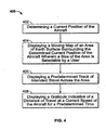
- Figure 4 is a flow chart of an exemplary method of displaying a current position of an aircraft.
- Figure 1 is a forward perspective view of an exemplary aircraft cockpit display panel 100 that includes at least one display screen 102 in accordance with an embodiment of the present invention.
- display screen is positioned on aircraft cockpit display panel 100.
- display screen 102 is positioned on an auxiliary panel (not shown) located in the cockpit of the aircraft.
- display screen 102 is available for viewing by a pilot and/or co-pilot of the aircraft.
- Display screen 102 may be used to view data included in an electronic flight bag (not shown), which may be embodied as a standalone device such as, but not limited to a PDA or laptop PC, or as a software component of a system executing on a processor that is part of a subsystem of the aircraft.
- the electronic flight bag includes an electronic storage device configured to store various user-configurable flight-related objects for all required and desired information for a particular flight, such as flight routes, as defined by way-points, airport information, temporary flight restrictions, and weather information as well as any other user-defined objects associated with a flight, ground operations, and/or flight planning.
- the electronic flight bag receives data from various aircraft and ground sensors and systems, determines flight information based on the received data in real-time, and displays the flight information and/or alerts the flight crew through display screen 102 and other aural and/or visual indicators positioned on cockpit display panel 100. Such flight information provides the flight crew with additional situational awareness during all phases of aircraft operation.
- Figure 2 is a screen shot 200 depicting an exemplary position indicating display system 202 for an aircraft.
- Position indicating display system 202 includes a moving map display screen 203 that represents of an area of the world being traversed by the aircraft.
- a current aircraft position indicator 204 is maintained proximate a center of display screen 203 or within a margin 205 of display screen 203.
- margin 205 is displayed for user convenience and is selectable to a non-displayed mode to reduce clutter on screen 203.
- a width of margin 205 is adjustable by a user.
- Margin 205 is selectably adjustable to permit keeping current aircraft position indicator 204 closer to the center of display screen 203 or to permit current aircraft position indicator 204 to traverse over a greater area of the display screen.
- the current aircraft position indicator 204 can be displayed on a north-up oriented map (as exemplarily depicted in Figure 2 ) or heading-up oriented moving map display (not shown).
- the area being traversed by the aircraft is the North Atlantic Ocean.
- the North Atlantic airways are the most heavily utilized oceanic routes in the world. Most routes are conveniently covered by ETOPS-120 min rules however, many of the North Atlantic diversion airports, especially those in Iceland and Greenland, are frequently subject to adverse weather conditions making them unavailable for use at certain times.
- a first overlay 206 on the moving map display is indicative of a predetermined track of travel, which in the exemplary embodiment, coincides with a North Atlantic Track (NATrack).
- NATrack North Atlantic Track
- North Atlantic Tracks are trans-Atlantic routes that stretch from the northeast of North America to the western coast of Europe across the Atlantic Ocean. These heavily-traveled routes are used by aircraft traveling between the United States, Canada, and Mexico and Europe and are updated daily based on a variety of factors. They are used by aircraft flying between the altitudes of approximately 9,449 (31,000) and approximately 12,192 (40,000) meters (feet), inclusive. The tracks reverse direction twice daily. During daylight hours all traffic on the tracks goes westbound. At night, all the tracks go eastbound towards Europe.
- the specific routing of the tracks are dictated based on a number of factors, the most important being the jetstream. Aircraft going to North America from Europe experience headwinds caused by the jetstream. Tracks to Europe use the jetstream to their advantage by routing along the strongest tailwinds.
- airline dispatchers Prior to departure, airline dispatchers will determine the best track based on destination, aircraft weight, and prevailing winds. Once airborne, the Atlantic Track portion of the flight plan will be confirmed. The aircraft will then contact the Oceanic Center controller before entering North Atlantic airspace and inform them of intended track, giving the estimated time of arrival at the entry point. While the route changes daily, a series of entrance and exit waypoints are maintained which link into the airspace system of North America and Europe. Each route is uniquely identified by a letter of the alphabet. Westbound tracks are indicated with a letter from the start of the alphabet (A, B, C, D, and E) and eastbound tracks with a letter from the end (S, T, U, V, W, X, Y).
- the moving map display also includes NATracks 208 and 210 that are north and/or south adjacent tracks of predetermined track of travel 206.
- Current aircraft position indicator 204 is maintained proximate the center or for example, approximately one-third of the display width from the display edge of the moving map display and provides additional information for the cockpit flight crew.
- a second overlay 212 appears as a graticule on moving map display 203 that circumscribes the radius in nautical miles or flying time in minutes of the approved area of extended range twin-engine operation (ETOPS) circles which is drawn around each adequate airport and which can be reached by the aircraft in the event that one engine becomes inoperative in accordance to existing regulations for ETOPS operations.
- ETOPS extended range twin-engine operation
- an adequate airport is an airport certified by the regulatory agencies to meet its safety requirements. A requirement for example is to have rescue and fire fighting services nearby.
- Second overlay 212 includes a shape that is configurable based on at least one of an aircraft type design approval and an operator approval.
- the distance is calculated by computing the horizontal distance covered during driftdown (descent to an altitude permitted with one engine inoperative) diversion from a normal cruise altitude at the approved single engine speed to the one engine inoperative cruise altitude following the loss of thrust from one engine. The diversion is continued at this speed and altitude until maximum diversion time is achieved.
- An adequate airport to divert to in the event of an engine loss must also be considered as suitable. Suitable airports are adequate airports with weather reports or forecasts, or any combination thereof, at the time of flight dispatch, indicating that the weather conditions will be at or above operating minima. A suitable airport also requires that field condition reports indicate a safe landing can be made from approximately one hour prior to approximately one hour after the anticipated time of arrival.
- ETOPS is an acronym for an International Civil Aviation Organization (ICAO) rule permitting twin-engined commercial air transports to fly routes that, at some points, are farther than 60 minutes from a suitable airport during one-engine-out conditions.
- IAO International Civil Aviation Organization
- ETOPS ranges are represented by circles surrounding airports that are candidates for diversion should the twin-engine aircraft lose an engine while traversing a route or track of an organized track system (OTS) such as a NATrack, which leads the aircraft more than 60 minutes from a suitable airport.
- OTS organized track system
- First overlay 206 is highlighted and must lie within a circular ring of the suitable alternate airport to be approved for ETOPS flight dispatch.
- Each airport that falls within second overlay 212 is highlighted on the moving map display such that selecting an airport to divert to is facilitated.
- position indicating display 202 is configured to provide situational awareness information and/or supplementary navigational information for use by the flight crew.
- Primary navigation means is generally provided by other system such as primary flight displays. However primary navigation functions are envisioned for position indicating display 202 in the future.
- the moving map display also includes at least one equal time point (ETP) 214 that indicates a substantially equal travel time from the ETP to alternate facilities capable of receiving the aircraft.
- ETP represents a point along the route, such as a NATRACK at which the aircraft may either proceed to destination or first suitable airport, or return to departure base or last suitable airport in substantially the same amount of time.
- An ETP is normally calculated under the assumption of still air.
- a transition 216 of controlled airspace into North Atlantic airspace is seamlessly represented on the moving map display such that the pilot does not need to switch between charts to maintain position indication along the route.
- the moving map displays additional information representing the flight plan along controlled airspace.
- extended range operations are those flights conducted over a route that contains a point further than one hour flying time at the approved one-engine inoperative cruise speed (under standard conditions in still air) from an adequate facility capable of receiving the aircraft such as an adequate airport.
- An extended range entry point (EEP) 218 is the point on the aircraft's outbound route which is one-hour's flying time at the approved single-engine inoperative cruise speed (under standard conditions in still air) from an adequate airport.
- An extended range exi.t point (EXP) 220 is the point on the aircraft's route, where the aircraft has been flying in an ETOPS segment which is one-hour's flying time at the approved single-engine inoperative cruise speed (under standard conditions in still air) to an adequate airport.
- Moving map display screen 203 includes at least one critical point 222 indicating a point along the route at which ETOPS diversion fuel requirements is equal to or greater than a normal destination fuel plan requirement.
- Figure 3 is a screen shot 300 depicting position indicating display system 202 illustrating a North Atlantic airspace entry point from European airspace.
- Position indicating display system 202 includes a moving map display representative of the western coast of Ireland 304.
- a flight plan 306 of an aircraft through European airspace is connected seamlessly to a predetermined NATrack 308 assigned to the aircraft for a North Atlantic airspace transit.
- Northern and southern NATracks 310 and 312 are also displayed for situational awareness.
- current aircraft position indicator 204 is displayed on the moving map display as described above with reference to Figure 2 .
- Figure 4 is a flow chart of an exemplary method 400 of displaying a current position of an aircraft.
- Method 400 includes determining 402 a current position of the aircraft, displaying 404 a moving map of an area of earth surface surrounding the determined current position of the aircraft wherein a size of the area is selectable by a user. The user may zoom in on an area to view the area in closer detail or zoom out to view a larger perspective of the aircraft position.
- Method 400 also includes displaying 406 a predetermined track of intended travel across the area, and displaying 408 a graticule indicative of a distance of travel at a current speed of the aircraft for a predetermined time.
- Method 400 also includes displaying at least one adjacent track to said predetermined track of intended travel.
- the intended track of travel is one NATrack extending across the North Atlantic Ocean.
- the adjacent tracks are northerly or southerly NATracks that are displayed to provide the flight crew with situational awareness of potential other aircraft in the vicinity of the aircraft.
- Method 400 determines at least one equal time point (ETP) indicating a substantially equal travel time from the ETP to alternate facilities capable of receiving the aircraft.
- ETP clearly indicates to the flight crew through ETP attached arrows which alternate airport to fly to should this become a necessity.
- the two arrows of an ETP point each in the direction of a suitable alternate airport.
- the ETP is dynamically determined using current flight route related ETOPS information.
- a position indicating system includes a moving map display that indicates the current position of an aircraft along a track of intended travel.
- the tracks may be North Atlantic tracks or other tracks of the organized track system (OTS) or routes over other areas where traditional land-based navigation aids and suitable airports are not readily available.
- OTS organized track system
Landscapes
- Engineering & Computer Science (AREA)
- Radar, Positioning & Navigation (AREA)
- Remote Sensing (AREA)
- Aviation & Aerospace Engineering (AREA)
- Physics & Mathematics (AREA)
- General Physics & Mathematics (AREA)
- Traffic Control Systems (AREA)
- Navigation (AREA)
- Devices For Checking Fares Or Tickets At Control Points (AREA)
- Train Traffic Observation, Control, And Security (AREA)
- Mobile Radio Communication Systems (AREA)
Claims (12)
- Positionsanzeigesystem (202) für ein Luftfahrzeug, wobei das Positionsanzeigesystem aufweist:- ein Sichtgerät mit einer nachführenden Kartenanzeige (203), die für ein von dem Luftfahrzeug durchquertes Gebiet in der Weise repräsentativ ist, dass eine aktuelle relative Position des Luftfahrzeugs (204) innerhalb eines auf dem Sichtgerät (203) eingegrenzten Gebiets (205) gehalten wird, und wobei die nachführende Kartenanzeige zumindest in einem Ausrichtungsmodus konfigurierbar ist, bei dem der Norden oben angeordnet ist oder die Bewegungsrichtung nach oben weist,- eine erste Einblendung (206) auf der nachführenden Kartenanzeige (203), die zumindest eine vorgegebene Reiseroute oder eine vorgegebene Strecke angibt, und- eine zweite Einblendung (212) auf der nachführenden Kartenanzeige (203), die einen Reiseentfernungsbereich oder einen Reisezeitbereich von einer zur Aufnahme des Luftfahrzeugs geeigneten Einrichtung angibt, wobei der Reiseentfernungsbereich und der Reisezeitbereich unter Verwendung der aktuellen Reisegeschwindigkeit des Luftfahrzeugs über Grund und einer vorgegebenen Zeitspanne bestimmt sind.
- System (202) nach Anspruch 1, worin die erste Einblendung (206) eine North Atlantic Track Route (NA Track) oder eine andere Route eines Organized Track Systems (OTS) angibt.
- System (202) nach Anspruch 1, worin die erste Einblendung (206) eine North Atlantic Track Route (NA Track) oder eine andere Route des OTS und zumindest eine benachbarten NA Track Route (208, 210) bzw. eine benachbarte OTS Route angibt.
- System (202) nach Anspruch 1, worin die erste Einblendung (206) zumindest einen Zeitgleichheitspunkt (ETP) (214) aufweist, der eine im Wesentlichen gleiche Reisezeit von dem ETP zu wechselnden, für ein Aufnehmen des Luftfahrzeugs geeigneten, Einrichtungen angibt.
- System (202) nach Anspruch 1, worin die erste Einblendung (206) zumindest einen Extended Range Entry Point (EEP) (218) aufweist, der den Punkt an einen ETOPS -Segment angibt, ab dem die Flugzeit für die Strecke von einer zum Aufnehmen des Luftfahrzeugs geeigneten Einrichtung bei einer für den Ausfall eines Triebwerks vorgegebenen Reisegeschwindigkeit mehr als ungefähr eine Stunde beträgt, wobei die zum Aufnehmen des Luftfahrzeugs geeignete Einrichtung zumindest Wetterberichte oder Wettervorhersagen berücksichtigt, die angeben, dass die Wetterbedingungen wenigstens die Minimalanforderungen an den Flugplatzbetrieb erfüllen, und die Berichte zu den Flugplatzbedingungen umfassen, die angeben, dass eine sichere Landung ab etwa einer Stunde vor bis etwa eine Stunde nach der vermutlichen Ankunftszeit möglich ist.
- System (202) nach Anspruch 1, worin die erste Einblendung (206) zumindest einen Extended Range Exit Point (EXP) (220) aufweist, der den Punkt an einen ETOPS -Segment angibt, ab dem die Flugzeit für die Strecke von einer zum Aufnehmen des Luftfahrzeugs geeigneten Einrichtung bei einer für den Ausfall eines Triebwerks vortschriftsmäßigen Reisegeschwindigkeit weniger als ungefähr eine Stunde beträgt.
- System (202) nach Anspruch 1, worin die erste Einblendung (206) zumindest einen kritischen Punkt (222) aufweist, der zumindest einen Punkt entlang der Route angibt, an dem der Treibstoffbedarf für eine ETOPS Umleitung gleich oder größer als der Treibstoffbedarf für reguläre Ziele ist.
- System (202) nach Anspruch 1, worin die zweite Einblendung (212) eine konfigurierbare Form aufweist, die eine Darstellung einer zum Aufnehmen des Luftfahrzeugs geeigneten Einrichtung auf der Anzeige umgibt, wobei die konfigurierbare Form wenigsten eine Reiseentfernung oder eine Reisezeit repräsentiert, die eine Darstellung einer zum Aufnehmen des Luftfahrzeugs geeigneten Einrichtung auf der Anzeige zu Umleitungszwecken umgeben, und wobei die Form auf Grundlage von zumindest einer Luftfahrzeugmustergenehmigung oder einer Betreibergenehmigung konfigurierbar ist.
- System (202) nach Anspruch 1, worin die zweite Einblendung (212) für einen Extended-Range Twin-Engine Operational Performance Standard (ETOPS) bezeichnend ist.
- System (202) nach Anspruch 1, worin die zweite Einblendung (212) eine Bezeichnung einer zum Aufnehmen des Luftfahrzeugs geeigneten Einrichtung umfasst, wenn die zweite Einblendung (212) die Position der Einrichtung auf der nachführenden Kartenanzeige abgrenzt.
- System (202) nach Anspruch 1, worin die zweite Einblendung (212) und eine dritte Einblendung wechselweise zur Anzeige auf der nachführenden Kartenanzeige (203) wählbar sind, wobei die dritte Einblendung auf der nachführenden Kartenanzeige einen Entfernungsbereich von einer zum Aufnehmen des Luftfahrzeugs geeigneten Einrichtung angibt, und wobei der Reiseentfernungsbereich unter Verwendung von zumindest der aktuellen Reisegeschwindigkeit des Luftfahrzeugs über Grund oder einer vorgegebenen Zeitspanne bestimmt ist.
- System (202) nach Anspruch 1, das ferner einen Eintrittspunkt in den kontrollierten Luftraum an einem ersten Ende der vorgegebenen Reiseroute und einen Austrittspunkt aus dem kontrollierten Luftraum an einem zweiten, entgegengesetzten Ende der vorgegebenen Reiseroute aufweist.
Applications Claiming Priority (3)
| Application Number | Priority Date | Filing Date | Title |
|---|---|---|---|
| US75329705P | 2005-12-22 | 2005-12-22 | |
| US11/533,202 US8271150B2 (en) | 2005-12-22 | 2006-09-19 | Methods and systems for displaying enroute moving maps |
| PCT/US2006/047315 WO2007075327A2 (en) | 2005-12-22 | 2006-12-12 | Methods and systems for displaying enroute moving maps |
Publications (2)
| Publication Number | Publication Date |
|---|---|
| EP1969317A2 EP1969317A2 (de) | 2008-09-17 |
| EP1969317B1 true EP1969317B1 (de) | 2010-05-05 |
Family
ID=38072495
Family Applications (1)
| Application Number | Title | Priority Date | Filing Date |
|---|---|---|---|
| EP06848982A Active EP1969317B1 (de) | 2005-12-22 | 2006-12-12 | Verfahren und systeme zum anzeigen von beweglichen karten auf der route |
Country Status (5)
| Country | Link |
|---|---|
| US (1) | US8271150B2 (de) |
| EP (1) | EP1969317B1 (de) |
| AT (1) | ATE467100T1 (de) |
| DE (1) | DE602006014208D1 (de) |
| WO (1) | WO2007075327A2 (de) |
Families Citing this family (28)
| Publication number | Priority date | Publication date | Assignee | Title |
|---|---|---|---|---|
| US7817078B2 (en) * | 2008-02-29 | 2010-10-19 | Honeywell International Inc. | Systems and methods for supplemental weather information presentation on a display |
| US8849477B2 (en) * | 2008-10-14 | 2014-09-30 | Honeywell International Inc. | Avionics display system and method for generating three dimensional display including error-compensated airspace |
| FR2940843B1 (fr) * | 2009-01-08 | 2011-03-11 | Airbus France | Procede et systeme de gestion automatique de listes de verification sur un aeronef |
| US8362925B2 (en) * | 2009-05-05 | 2013-01-29 | Honeywell International Inc. | Avionics display system and method for generating flight information pertaining to neighboring aircraft |
| US8515658B1 (en) * | 2009-07-06 | 2013-08-20 | The Boeing Company | Managing navigational chart presentation |
| US9029377B2 (en) * | 2009-07-24 | 2015-05-12 | Merck Sharp & Dohme Corp. | Platelet-activating factor receptor antagonists |
| US8442704B2 (en) | 2009-08-06 | 2013-05-14 | Airbus Engineering Centre India | System and method for computing an equi-distance point (EDP) for aircrafts |
| US8914257B1 (en) | 2009-08-27 | 2014-12-16 | The Boeing Company | Simulating a surface of a structure |
| US8583368B1 (en) * | 2010-02-17 | 2013-11-12 | The Boeing Company | Rule based depiction of minimum altitudes |
| US9753894B2 (en) | 2010-09-08 | 2017-09-05 | The Boeing Company | Establishing availability of a two-engine aircraft for an ETOPS flight or an ETOPS flight path for a two-engine aircraft |
| US8700363B2 (en) * | 2010-09-08 | 2014-04-15 | The Boeing Company | ETOPS IFSD risk calculator |
| US9132913B1 (en) | 2013-09-26 | 2015-09-15 | Rockwell Collins, Inc. | Simplified auto-flight system coupled with a touchscreen flight control panel |
| US9691287B1 (en) * | 2013-09-26 | 2017-06-27 | Rockwell Collins, Inc. | Graphical method to set vertical and lateral flight management system constraints |
| US8756012B2 (en) | 2012-02-03 | 2014-06-17 | Honeywell International Inc. | System and method for displaying performance based range and time scales on a navigation display |
| USD678153S1 (en) * | 2012-02-10 | 2013-03-19 | Bell Helicopter Textron Inc. | Main cockpit control panel |
| USD689007S1 (en) * | 2012-02-29 | 2013-09-03 | Rockwell Collins, Inc. | Avionics flight display |
| USD689008S1 (en) * | 2012-02-29 | 2013-09-03 | Rockwell Collins, Inc. | Avionics flight display |
| USD689009S1 (en) * | 2012-02-29 | 2013-09-03 | Rockwell Collins, Inc. | Avionics flight display |
| USD689010S1 (en) * | 2012-02-29 | 2013-09-03 | Rockwell Collins, Inc. | Avionics flight display |
| JP6459014B2 (ja) | 2015-03-31 | 2019-01-30 | エスゼット ディージェイアイ テクノロジー カンパニー リミテッドSz Dji Technology Co.,Ltd | ジオフェンシング装置 |
| EP3140710B1 (de) * | 2015-03-31 | 2018-10-17 | SZ DJI Technology Co., Ltd. | Systeme und verfahren mit geofencing-vorrichtung-hierarchie |
| CN107409051B (zh) | 2015-03-31 | 2021-02-26 | 深圳市大疆创新科技有限公司 | 用于生成飞行管制的认证系统和方法 |
| US10473484B1 (en) * | 2016-04-01 | 2019-11-12 | Hilton Goldstein | System and method for mapping aircraft position on a non-linear flight procedure chart |
| US10891867B2 (en) | 2016-09-15 | 2021-01-12 | The Mitre Corporation | Digital copilot |
| US10321221B1 (en) | 2018-05-14 | 2019-06-11 | The Mitre Corporation | Aviation intercommunication system to mobile computing device interface |
| US20200043349A1 (en) * | 2018-08-02 | 2020-02-06 | Avplat India Pvt Ltd | System for plotting flight route |
| US11512959B2 (en) * | 2018-10-15 | 2022-11-29 | Scott International Procedures, LLC | Portable flight navigation tool adapted to assist pilots in compliance with international flight procedures and navigation |
| US12435981B2 (en) * | 2018-10-15 | 2025-10-07 | Scott International Procedures, LLC | Portable flight navigation tool adapted to assist pilots in compliance with international flight procedures and navigation |
Family Cites Families (26)
| Publication number | Priority date | Publication date | Assignee | Title |
|---|---|---|---|---|
| US4642775A (en) * | 1984-05-25 | 1987-02-10 | Sundstrand Data Control, Inc. | Airborne flight planning and information system |
| US6195609B1 (en) * | 1993-09-07 | 2001-02-27 | Harold Robert Pilley | Method and system for the control and management of an airport |
| FR2694392B1 (fr) * | 1992-07-31 | 1994-10-07 | Sextant Avionique | Procédé d'assistance à la navigation. |
| US5978715A (en) * | 1997-10-15 | 1999-11-02 | Dassault Aviation | Apparatus and method for aircraft display and control |
| US6038498A (en) * | 1997-10-15 | 2000-03-14 | Dassault Aviation | Apparatus and mehod for aircraft monitoring and control including electronic check-list management |
| US6112141A (en) * | 1997-10-15 | 2000-08-29 | Dassault Aviation | Apparatus and method for graphically oriented aircraft display and control |
| US6247019B1 (en) * | 1998-03-17 | 2001-06-12 | Prc Public Sector, Inc. | Object-based geographic information system (GIS) |
| WO2000065423A2 (en) * | 1999-04-01 | 2000-11-02 | Price Ricardo A | Electronic flight instrument displays |
| US6922631B1 (en) * | 2000-10-06 | 2005-07-26 | Honeywell International Inc. | System and method for textually displaying an original flight plan and a modified flight plan simultaneously |
| CN1476593A (zh) * | 2000-10-25 | 2004-02-18 | �������ϰ�װ��������˾ | 用于座舱交通显示的飞行员可编程高度范围过滤器 |
| US6671589B2 (en) * | 2001-02-13 | 2003-12-30 | William Holst | Method and apparatus to support remote and automatically initiated data loading and data acquisition of airborne computers using a wireless spread spectrum aircraft data services link |
| US6519527B2 (en) | 2001-03-19 | 2003-02-11 | Kabushiki Kaisha Toshiba | Navigation assisting system, flight-route calculating method, and navigation assisting method |
| US6573841B2 (en) * | 2001-04-02 | 2003-06-03 | Chelton Flight Systems Inc. | Glide range depiction for electronic flight instrument displays |
| US6804585B2 (en) * | 2001-06-19 | 2004-10-12 | John Jay Humbard | Flight management system and method for providing navigational reference to emergency landing locations |
| WO2003062754A1 (en) * | 2002-01-24 | 2003-07-31 | Toyota Motor Sales, U.S.A., Inc. | Apparatus and methods for providing a flight display in an aircraft |
| US6597294B1 (en) * | 2002-04-12 | 2003-07-22 | Jeffrey Ariens | Multi-function flight information display unit MFIDU |
| US6745115B1 (en) * | 2003-01-07 | 2004-06-01 | Garmin Ltd. | System, method and apparatus for searching geographic area using prioritized spacial order |
| US7735005B2 (en) * | 2003-09-11 | 2010-06-08 | The Boeing Company | Style guide and formatting methods for pilot quick reference handbooks |
| US7321318B2 (en) * | 2004-03-31 | 2008-01-22 | The Boeing Company | Methods and systems for controlling the display of information at an aircraft flight deck |
| US7256710B2 (en) * | 2004-06-30 | 2007-08-14 | The Boeing Company | Methods and systems for graphically displaying sources for and natures of aircraft flight control instructions |
| US7420476B2 (en) * | 2005-01-07 | 2008-09-02 | Raytheon Company | Programmable cockpit upgrade system |
| US6961643B1 (en) * | 2005-02-02 | 2005-11-01 | Tru Trak Flight Systems, Inc | System and method for gyro enhanced vertical flight information |
| US8255112B2 (en) * | 2005-10-28 | 2012-08-28 | The Boeing Company | Remote aircraft maintenance in a networked environment |
| US8341298B2 (en) * | 2005-12-02 | 2012-12-25 | The Boeing Company | Scalable on-board open data network architecture |
| US7352292B2 (en) * | 2006-01-20 | 2008-04-01 | Keith Alter | Real-time, three-dimensional synthetic vision display of sensor-validated terrain data |
| US7295135B2 (en) * | 2006-02-06 | 2007-11-13 | Trutrak Flight Systems, Inc. | Flight information system |
-
2006
- 2006-09-19 US US11/533,202 patent/US8271150B2/en active Active
- 2006-12-12 EP EP06848982A patent/EP1969317B1/de active Active
- 2006-12-12 WO PCT/US2006/047315 patent/WO2007075327A2/en not_active Ceased
- 2006-12-12 DE DE602006014208T patent/DE602006014208D1/de active Active
- 2006-12-12 AT AT06848982T patent/ATE467100T1/de not_active IP Right Cessation
Also Published As
| Publication number | Publication date |
|---|---|
| WO2007075327A2 (en) | 2007-07-05 |
| ATE467100T1 (de) | 2010-05-15 |
| US20070150124A1 (en) | 2007-06-28 |
| US8271150B2 (en) | 2012-09-18 |
| EP1969317A2 (de) | 2008-09-17 |
| WO2007075327A3 (en) | 2007-08-16 |
| DE602006014208D1 (de) | 2010-06-17 |
Similar Documents
| Publication | Publication Date | Title |
|---|---|---|
| US8271150B2 (en) | Methods and systems for displaying enroute moving maps | |
| US20220005362A1 (en) | Flight assistant | |
| US6957130B1 (en) | Navigational instrument, method and computer program product for displaying ground traffic information | |
| EP2533015B1 (de) | Verfahren und Systeme zur Anzeige von Prozedurinformation auf einem Flugzeugbildschirm | |
| US7308343B1 (en) | Navigational instrument, method and computer program product for displaying ground traffic information | |
| RU2550887C2 (ru) | Бортовая интегрированная система информационной поддержки экипажа и когнитивный формат представления полетной информации на этапе "взлет" многодвигательного воздушного судна | |
| US6038498A (en) | Apparatus and mehod for aircraft monitoring and control including electronic check-list management | |
| US9884690B2 (en) | Methods and systems for conveying destination viability | |
| EP3056863B1 (de) | Flugzeugsystem mit verbesserten notams | |
| US8467966B2 (en) | Device for aiding the flight management of an aircraft | |
| EP2793206B1 (de) | Verfahren und Systeme zur Anzeige von Verfahrensinformation auf einem Flugzeugbildschirm | |
| EP2400273A2 (de) | Verfahren und Systeme zur Anzeige von Anmerkungen auf einem Flugzeugbildschirm | |
| US11657721B1 (en) | Aircraft with flight assistant | |
| US20230060442A1 (en) | Portable Flight Navigation Tool Adapted to Assist Pilots in Compliance with International Flight Procedures and Navigation | |
| US20230060551A1 (en) | Runway awareness and alerting systems and methods | |
| US11574549B2 (en) | Composite vertical profile display systems and methods | |
| US10311738B2 (en) | Display system and method for indicating a time-based requirement | |
| US12272259B1 (en) | Aircraft emergency resolution system and apparatus | |
| EP3657131B1 (de) | Verfahren und systeme zur darstellung von wegpunktlisten | |
| EP4151953A1 (de) | Zeitbasierte überlagerung für positionskartenanzeigen | |
| US20080270020A1 (en) | Method, Arrangement and Monitoring Device for Navigation of Aircraft and Ground Vehicles Using Satellite-Assisted Positioning | |
| EP1764759A1 (de) | Systeme und Verfahren zur Anzeige von geschütztem oder gesperrtem Luftraum in einem Flugzeug | |
| WO2007006310A2 (en) | Method of making data available to a pilot | |
| US7756637B2 (en) | Methods and systems for displaying electronic enroute maps | |
| EP3985646A1 (de) | Systeme und verfahren zur anzeige von zusammengesetzten vertikalen profilen |
Legal Events
| Date | Code | Title | Description |
|---|---|---|---|
| PUAI | Public reference made under article 153(3) epc to a published international application that has entered the european phase |
Free format text: ORIGINAL CODE: 0009012 |
|
| 17P | Request for examination filed |
Effective date: 20080716 |
|
| AK | Designated contracting states |
Kind code of ref document: A2 Designated state(s): AT BE BG CH CY CZ DE DK EE ES FI FR GB GR HU IE IS IT LI LT LU LV MC NL PL PT RO SE SI SK TR |
|
| 17Q | First examination report despatched |
Effective date: 20081027 |
|
| RIN1 | Information on inventor provided before grant (corrected) |
Inventor name: WIESEMANN, THORSTEN Inventor name: WIPPLINGER, PATRICK Inventor name: SCHIEFELE, JENS |
|
| GRAP | Despatch of communication of intention to grant a patent |
Free format text: ORIGINAL CODE: EPIDOSNIGR1 |
|
| GRAS | Grant fee paid |
Free format text: ORIGINAL CODE: EPIDOSNIGR3 |
|
| GRAA | (expected) grant |
Free format text: ORIGINAL CODE: 0009210 |
|
| AK | Designated contracting states |
Kind code of ref document: B1 Designated state(s): AT BE BG CH CY CZ DE DK EE ES FI FR GB GR HU IE IS IT LI LT LU LV MC NL PL PT RO SE SI SK TR |
|
| REG | Reference to a national code |
Ref country code: GB Ref legal event code: FG4D |
|
| REG | Reference to a national code |
Ref country code: CH Ref legal event code: EP |
|
| REG | Reference to a national code |
Ref country code: IE Ref legal event code: FG4D |
|
| REF | Corresponds to: |
Ref document number: 602006014208 Country of ref document: DE Date of ref document: 20100617 Kind code of ref document: P |
|
| REG | Reference to a national code |
Ref country code: DE Ref legal event code: R096 Ref document number: 602006014208 Country of ref document: DE Effective date: 20100617 |
|
| REG | Reference to a national code |
Ref country code: NL Ref legal event code: VDEP Effective date: 20100505 |
|
| LTIE | Lt: invalidation of european patent or patent extension |
Effective date: 20100505 |
|
| PG25 | Lapsed in a contracting state [announced via postgrant information from national office to epo] |
Ref country code: SE Free format text: LAPSE BECAUSE OF FAILURE TO SUBMIT A TRANSLATION OF THE DESCRIPTION OR TO PAY THE FEE WITHIN THE PRESCRIBED TIME-LIMIT Effective date: 20100505 Ref country code: NL Free format text: LAPSE BECAUSE OF FAILURE TO SUBMIT A TRANSLATION OF THE DESCRIPTION OR TO PAY THE FEE WITHIN THE PRESCRIBED TIME-LIMIT Effective date: 20100505 Ref country code: LT Free format text: LAPSE BECAUSE OF FAILURE TO SUBMIT A TRANSLATION OF THE DESCRIPTION OR TO PAY THE FEE WITHIN THE PRESCRIBED TIME-LIMIT Effective date: 20100505 Ref country code: ES Free format text: LAPSE BECAUSE OF FAILURE TO SUBMIT A TRANSLATION OF THE DESCRIPTION OR TO PAY THE FEE WITHIN THE PRESCRIBED TIME-LIMIT Effective date: 20100816 |
|
| PG25 | Lapsed in a contracting state [announced via postgrant information from national office to epo] |
Ref country code: AT Free format text: LAPSE BECAUSE OF FAILURE TO SUBMIT A TRANSLATION OF THE DESCRIPTION OR TO PAY THE FEE WITHIN THE PRESCRIBED TIME-LIMIT Effective date: 20100505 Ref country code: FI Free format text: LAPSE BECAUSE OF FAILURE TO SUBMIT A TRANSLATION OF THE DESCRIPTION OR TO PAY THE FEE WITHIN THE PRESCRIBED TIME-LIMIT Effective date: 20100505 Ref country code: IS Free format text: LAPSE BECAUSE OF FAILURE TO SUBMIT A TRANSLATION OF THE DESCRIPTION OR TO PAY THE FEE WITHIN THE PRESCRIBED TIME-LIMIT Effective date: 20100905 Ref country code: LV Free format text: LAPSE BECAUSE OF FAILURE TO SUBMIT A TRANSLATION OF THE DESCRIPTION OR TO PAY THE FEE WITHIN THE PRESCRIBED TIME-LIMIT Effective date: 20100505 Ref country code: SI Free format text: LAPSE BECAUSE OF FAILURE TO SUBMIT A TRANSLATION OF THE DESCRIPTION OR TO PAY THE FEE WITHIN THE PRESCRIBED TIME-LIMIT Effective date: 20100505 |
|
| PG25 | Lapsed in a contracting state [announced via postgrant information from national office to epo] |
Ref country code: CY Free format text: LAPSE BECAUSE OF FAILURE TO SUBMIT A TRANSLATION OF THE DESCRIPTION OR TO PAY THE FEE WITHIN THE PRESCRIBED TIME-LIMIT Effective date: 20100602 Ref country code: PL Free format text: LAPSE BECAUSE OF FAILURE TO SUBMIT A TRANSLATION OF THE DESCRIPTION OR TO PAY THE FEE WITHIN THE PRESCRIBED TIME-LIMIT Effective date: 20100505 |
|
| PG25 | Lapsed in a contracting state [announced via postgrant information from national office to epo] |
Ref country code: PT Free format text: LAPSE BECAUSE OF FAILURE TO SUBMIT A TRANSLATION OF THE DESCRIPTION OR TO PAY THE FEE WITHIN THE PRESCRIBED TIME-LIMIT Effective date: 20100906 Ref country code: DK Free format text: LAPSE BECAUSE OF FAILURE TO SUBMIT A TRANSLATION OF THE DESCRIPTION OR TO PAY THE FEE WITHIN THE PRESCRIBED TIME-LIMIT Effective date: 20100505 Ref country code: EE Free format text: LAPSE BECAUSE OF FAILURE TO SUBMIT A TRANSLATION OF THE DESCRIPTION OR TO PAY THE FEE WITHIN THE PRESCRIBED TIME-LIMIT Effective date: 20100505 Ref country code: GR Free format text: LAPSE BECAUSE OF FAILURE TO SUBMIT A TRANSLATION OF THE DESCRIPTION OR TO PAY THE FEE WITHIN THE PRESCRIBED TIME-LIMIT Effective date: 20100806 |
|
| PG25 | Lapsed in a contracting state [announced via postgrant information from national office to epo] |
Ref country code: BE Free format text: LAPSE BECAUSE OF FAILURE TO SUBMIT A TRANSLATION OF THE DESCRIPTION OR TO PAY THE FEE WITHIN THE PRESCRIBED TIME-LIMIT Effective date: 20100505 Ref country code: RO Free format text: LAPSE BECAUSE OF FAILURE TO SUBMIT A TRANSLATION OF THE DESCRIPTION OR TO PAY THE FEE WITHIN THE PRESCRIBED TIME-LIMIT Effective date: 20100505 Ref country code: SK Free format text: LAPSE BECAUSE OF FAILURE TO SUBMIT A TRANSLATION OF THE DESCRIPTION OR TO PAY THE FEE WITHIN THE PRESCRIBED TIME-LIMIT Effective date: 20100505 Ref country code: CZ Free format text: LAPSE BECAUSE OF FAILURE TO SUBMIT A TRANSLATION OF THE DESCRIPTION OR TO PAY THE FEE WITHIN THE PRESCRIBED TIME-LIMIT Effective date: 20100505 |
|
| PLBE | No opposition filed within time limit |
Free format text: ORIGINAL CODE: 0009261 |
|
| STAA | Information on the status of an ep patent application or granted ep patent |
Free format text: STATUS: NO OPPOSITION FILED WITHIN TIME LIMIT |
|
| PG25 | Lapsed in a contracting state [announced via postgrant information from national office to epo] |
Ref country code: IT Free format text: LAPSE BECAUSE OF FAILURE TO SUBMIT A TRANSLATION OF THE DESCRIPTION OR TO PAY THE FEE WITHIN THE PRESCRIBED TIME-LIMIT Effective date: 20100505 |
|
| 26N | No opposition filed |
Effective date: 20110208 |
|
| REG | Reference to a national code |
Ref country code: DE Ref legal event code: R097 Ref document number: 602006014208 Country of ref document: DE Effective date: 20110207 Ref country code: DE Ref legal event code: R097 Ref document number: 602006014208 Country of ref document: DE Effective date: 20110208 |
|
| PG25 | Lapsed in a contracting state [announced via postgrant information from national office to epo] |
Ref country code: MC Free format text: LAPSE BECAUSE OF NON-PAYMENT OF DUE FEES Effective date: 20101231 |
|
| REG | Reference to a national code |
Ref country code: CH Ref legal event code: PL |
|
| PG25 | Lapsed in a contracting state [announced via postgrant information from national office to epo] |
Ref country code: CH Free format text: LAPSE BECAUSE OF NON-PAYMENT OF DUE FEES Effective date: 20101231 Ref country code: IE Free format text: LAPSE BECAUSE OF NON-PAYMENT OF DUE FEES Effective date: 20101212 Ref country code: LI Free format text: LAPSE BECAUSE OF NON-PAYMENT OF DUE FEES Effective date: 20101231 |
|
| PG25 | Lapsed in a contracting state [announced via postgrant information from national office to epo] |
Ref country code: LU Free format text: LAPSE BECAUSE OF NON-PAYMENT OF DUE FEES Effective date: 20101212 Ref country code: BG Free format text: LAPSE BECAUSE OF FAILURE TO SUBMIT A TRANSLATION OF THE DESCRIPTION OR TO PAY THE FEE WITHIN THE PRESCRIBED TIME-LIMIT Effective date: 20100505 Ref country code: HU Free format text: LAPSE BECAUSE OF FAILURE TO SUBMIT A TRANSLATION OF THE DESCRIPTION OR TO PAY THE FEE WITHIN THE PRESCRIBED TIME-LIMIT Effective date: 20101106 |
|
| PG25 | Lapsed in a contracting state [announced via postgrant information from national office to epo] |
Ref country code: TR Free format text: LAPSE BECAUSE OF FAILURE TO SUBMIT A TRANSLATION OF THE DESCRIPTION OR TO PAY THE FEE WITHIN THE PRESCRIBED TIME-LIMIT Effective date: 20100505 |
|
| PG25 | Lapsed in a contracting state [announced via postgrant information from national office to epo] |
Ref country code: BG Free format text: LAPSE BECAUSE OF FAILURE TO SUBMIT A TRANSLATION OF THE DESCRIPTION OR TO PAY THE FEE WITHIN THE PRESCRIBED TIME-LIMIT Effective date: 20100805 |
|
| REG | Reference to a national code |
Ref country code: FR Ref legal event code: PLFP Year of fee payment: 10 |
|
| REG | Reference to a national code |
Ref country code: FR Ref legal event code: PLFP Year of fee payment: 11 |
|
| REG | Reference to a national code |
Ref country code: FR Ref legal event code: PLFP Year of fee payment: 12 |
|
| P01 | Opt-out of the competence of the unified patent court (upc) registered |
Effective date: 20230516 |
|
| PGFP | Annual fee paid to national office [announced via postgrant information from national office to epo] |
Ref country code: GB Payment date: 20251222 Year of fee payment: 20 |
|
| PGFP | Annual fee paid to national office [announced via postgrant information from national office to epo] |
Ref country code: FR Payment date: 20251229 Year of fee payment: 20 |
|
| PGFP | Annual fee paid to national office [announced via postgrant information from national office to epo] |
Ref country code: DE Payment date: 20251223 Year of fee payment: 20 |
|
| REG | Reference to a national code |
Ref country code: DE Ref legal event code: R081 Ref document number: 602006014208 Country of ref document: DE Owner name: JEPPESEN FOREFLIGHT, INC. (N.D. GES. D. STAATE, US Free format text: FORMER OWNER: THE BOEING CO., CHICAGO, ILL., US Ref country code: DE Ref legal event code: R082 Ref document number: 602006014208 Country of ref document: DE Representative=s name: BOULT WADE TENNANT LLP, DE |
|
| REG | Reference to a national code |
Ref country code: GB Ref legal event code: 732E Free format text: REGISTERED BETWEEN 20260402 AND 20260408 |