EP2026037A2 - Système de navigation et son procédé correspondant pour alignement de boussole gyroscopique utilisant des données de capteur étalonné dynamiquement et un filtre Kalman étendu à itération - Google Patents
Système de navigation et son procédé correspondant pour alignement de boussole gyroscopique utilisant des données de capteur étalonné dynamiquement et un filtre Kalman étendu à itération Download PDFInfo
- Publication number
- EP2026037A2 EP2026037A2 EP08162274A EP08162274A EP2026037A2 EP 2026037 A2 EP2026037 A2 EP 2026037A2 EP 08162274 A EP08162274 A EP 08162274A EP 08162274 A EP08162274 A EP 08162274A EP 2026037 A2 EP2026037 A2 EP 2026037A2
- Authority
- EP
- European Patent Office
- Prior art keywords
- sensor data
- data
- processing device
- kalman filter
- dynamically
- Prior art date
- Legal status (The legal status is an assumption and is not a legal conclusion. Google has not performed a legal analysis and makes no representation as to the accuracy of the status listed.)
- Withdrawn
Links
- 238000000034 method Methods 0.000 title claims abstract description 27
- 238000012545 processing Methods 0.000 claims abstract description 50
- 238000005259 measurement Methods 0.000 claims abstract description 31
- 239000011159 matrix material Substances 0.000 claims description 26
- 238000006243 chemical reaction Methods 0.000 claims description 20
- 230000001133 acceleration Effects 0.000 claims description 4
- 238000012935 Averaging Methods 0.000 claims description 3
- 230000005484 gravity Effects 0.000 description 6
- 230000009021 linear effect Effects 0.000 description 6
- 230000009022 nonlinear effect Effects 0.000 description 6
- 238000013459 approach Methods 0.000 description 2
- 238000010586 diagram Methods 0.000 description 2
- NCGICGYLBXGBGN-UHFFFAOYSA-N 3-morpholin-4-yl-1-oxa-3-azonia-2-azanidacyclopent-3-en-5-imine;hydrochloride Chemical compound Cl.[N-]1OC(=N)C=[N+]1N1CCOCC1 NCGICGYLBXGBGN-UHFFFAOYSA-N 0.000 description 1
- 238000004364 calculation method Methods 0.000 description 1
- 238000012937 correction Methods 0.000 description 1
- 238000005312 nonlinear dynamic Methods 0.000 description 1
- 230000035945 sensitivity Effects 0.000 description 1
- 230000033772 system development Effects 0.000 description 1
- 230000007704 transition Effects 0.000 description 1
Images


Classifications
-
- G—PHYSICS
- G01—MEASURING; TESTING
- G01C—MEASURING DISTANCES, LEVELS OR BEARINGS; SURVEYING; NAVIGATION; GYROSCOPIC INSTRUMENTS; PHOTOGRAMMETRY OR VIDEOGRAMMETRY
- G01C21/00—Navigation; Navigational instruments not provided for in groups G01C1/00 - G01C19/00
- G01C21/10—Navigation; Navigational instruments not provided for in groups G01C1/00 - G01C19/00 by using measurements of speed or acceleration
- G01C21/12—Navigation; Navigational instruments not provided for in groups G01C1/00 - G01C19/00 by using measurements of speed or acceleration executed aboard the object being navigated; Dead reckoning
- G01C21/16—Navigation; Navigational instruments not provided for in groups G01C1/00 - G01C19/00 by using measurements of speed or acceleration executed aboard the object being navigated; Dead reckoning by integrating acceleration or speed, i.e. inertial navigation
- G01C21/165—Navigation; Navigational instruments not provided for in groups G01C1/00 - G01C19/00 by using measurements of speed or acceleration executed aboard the object being navigated; Dead reckoning by integrating acceleration or speed, i.e. inertial navigation combined with non-inertial navigation instruments
- G01C21/1654—Navigation; Navigational instruments not provided for in groups G01C1/00 - G01C19/00 by using measurements of speed or acceleration executed aboard the object being navigated; Dead reckoning by integrating acceleration or speed, i.e. inertial navigation combined with non-inertial navigation instruments with electromagnetic compass
-
- G—PHYSICS
- G01—MEASURING; TESTING
- G01C—MEASURING DISTANCES, LEVELS OR BEARINGS; SURVEYING; NAVIGATION; GYROSCOPIC INSTRUMENTS; PHOTOGRAMMETRY OR VIDEOGRAMMETRY
- G01C25/00—Manufacturing, calibrating, cleaning, or repairing instruments or devices referred to in the other groups of this subclass
- G01C25/005—Manufacturing, calibrating, cleaning, or repairing instruments or devices referred to in the other groups of this subclass initial alignment, calibration or starting-up of inertial devices
Definitions
- Navigation systems are one example of nonlinear dynamic systems.
- One of the problems associated with navigation system development is the estimation of the various states of the dynamic system. Such estimations typically utilize navigation system software.
- the extended Kalman filter (EKF) has been used within navigation system software to make such estimations.
- the EKF applies a Taylor series expansion for nonlinear system and observation equations, and utilizes first order terms to apply the well-known linear Kalman filter theory, where the probability density function (PDF) is assumed to be Gaussian.
- PDF probability density function
- the EKF has shown several limitations.
- One of the limitations is that only small errors are allowed to be input into the EKF. Otherwise, in the presence of nonlinear error behavior, the first-order approximations can cause biased solutions and inconsistencies in updating of the covariance matrix, which can lead to filter instability. While second-order versions of the EKF exist, their increased implementation and computation complexity tend to prohibit their use.
- a popular technique to improve the first-order approach is the iterated EKF, which effectively iterates the EKF equations at the current time observation by redefining the nominal state estimate and re-linearizing the measurement equations.
- the iterated EKF is capable of providing better performance than the basic EKF, especially in the case of significant nonlinearity in the measurement function.
- INS inertial navigation systems
- GPS range measuring device and an INS which provides data relating to an angular velocity, velocity, and azimuth measuring, which are used in combination to measure motion of a mobile object (e.g., airplane).
- the navigation systems also contain range error estimating devices. Based on the output of the error estimating devices, position of the mobile object can be determined.
- the error estimating devices are sometimes implemented using Kalman filters and averaging processes.
- the outputs of the various measuring devices are thereby corrected using Kalman filters and the like so that the position of the mobile object can be estimated with a relatively high level of accuracy without using a high precision sensor.
- Kalman filters due to the nature of high noise, nonlinear effects, and imprecise measurements associated with low cost MEMS sensors, traditional EKF estimation will degrade with time and become unreliable. Therefore, the accuracy of the INS is limited, especially when GPS data is not available.
- Most nonlinear Kalman filters can be used to improve an estimation error, however, such implementations are difficult. More specifically, such implementations are difficult to tune and additionally it is difficult to switch estimation schemes because the nonlinear effect only shows up in certain scenarios.
- IMU inertial measurement unit
- the present invention includes a navigation system for an aircraft that includes an inertial measurement device configured to provide a first set of sensor data relating to operation of the aircraft and a positioning unit configured to provide a second set of data relating to position of the aircraft.
- the navigation system includes a processing device configured to receive the data sets provided by the inertial measurement device and the positioning device, and the processing device is configured to dynamically calibrate the received first data set, the processing device includes a Kalman filter, and the processing device is further configured to generate a gyrocompass alignment using the first dynamically calibrated first data set, the second data set, and the Kalman filter.
- the inertial measurement device includes microelectromechanical systems (MEMS) based accelerometers and gyros.
- MEMS microelectromechanical systems
- the processing device is configured to real-time average the first set of sensor data, the processing device is configured to estimate a heading based on the dynamically calibrated first set of sensor data, and the processing device is configured to generate a gyrocompass alignment using the estimated heading.
- the processing device is configured to initialize a conversion matrix using at least a portion of the estimated heading and the processing device is further configured to initialize the Kalman filter using the initialized conversion matrix.
- the processing device is configured to estimate sensor error using the real-time averaged first set of sensor data, and the processing device is further configured to correct the estimated sensor error with known gravitational acceleration and earth rate values to generate the dynamically calibrated first set of sensor data.
- the invention includes a method for gyrocompass alignment, the method including receiving sensor data from a plurality of sensors, dynamically calibrating at least a portion of the sensor data, and generating gyrocompass alignment information based on the dynamically calibrated sensor data.
- the method includes displaying a navigation output based on the generated gyrocompass alignment information.
- the method includes estimating a heading based on the dynamically calibrated sensor data, initializing a conversion matrix using at least a portion of the estimated heading, and initializing an iterated extended Kalman filter using the initialized conversion matrix.
- the invention provides a system and method for gyrocompass alignment using dynamically calibrated sensor data.
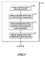
- FIGURE 1 is a block diagram of a multiple input navigation system incorporating an iterated Kalman filter operable to provide a position solution in a number of operating modes;
- FIGURES 2-5 are flowcharts of a method of generating navigation output in accordance with an embodiment of the invention
- FIGURE 1 is a block diagram of a navigation system 50 which includes a processing device 51 that includes a navigation processor 52 configured to dynamically switch between Kalman filter implementations in order to at least partially address the problems associated with processing of non-linear errors as described above.
- the navigation system 50 is used in a mobile object (not shown) such as an aircraft or a spacecraft.
- dynamically switching between Kalman filter implementations is utilized to address problems associated with gyroscope compass alignment times.
- this dynamic switching provides the navigation processor 52 with a capability to counter non-linear effects in received inertial data when estimating a position and reduce gyroscope compass alignment times for the navigation system 50.
- gyrocompass alignment times are reduced by using dynamic calibration of accelerometer and gyro data, estimation of heading based on the dynamically calibrated data, initialization of a conversion matrix using estimated heading information, and initialization of an iterated extended Kalman filter (IEKF) with the conversion matrix, further described with reference to FIGURES 2-5 .
- INKF extended Kalman filter
- the navigation system 50 includes an inertial measurement device with inertial sensors 60 having, for example, MEMS-based gyroscopes and accelerometers.
- the navigation system 50 also includes other sensors such as a barometric altimeter 62, a GPS receiver positioning unit 64, a true airspeed (TAS) indicator 66, and a magnetometer 67. Other types and fewer or greater numbers of sensors may also be included in the navigation system 50 in some examples.
- the navigation system 50 also includes a gravitation input 68 and an earth rate input 69.
- the gravitation input 68 is a digitally stored world gravitational map that is accessible by the processing device 51 in one example.
- gyros included in the inertial sensors 60 record components (x, y, and z) of earth-rate and accelerometers included in the inertial sensors 60 record components (x, y, and z) of gravity.
- the value of gravity used in the gravitation input 68 is determined using gravitational information associated with a standard reference frame such as the World Geodetic System (WGS), revision WGS 84.
- the earth-rate is a constant regardless of where the navigation system 50 is located on the surface of the earth.
- the earth-rate input 69 and the gravitation input 68 are used for calibration to determine a "bias" or "scale-factor" of the inertial sensors 60.
- the processing device 51 can then generate compensated sensor data based on information from the inertial sensors 60, the gravitation input 68, and the earth-rate input 69. Components (x, y, and z) of the compensated gyro and accelerometer sensor data are then used by the processing device 51 to generate a heading.
- the processing device 51 also includes an input processing unit 70 that processes the data from the listed sensing devices and outputs the combined sensor data 72 to the navigation processor 52.
- the navigation processor 52 utilizes an iterated, extended Kalman filter (IEKF) 74 to remove errors from the combined sensor data 72 and provide accurate navigational output data 78 to a navigation display device 80 and back into the input processing unit 70.
- the IEKF 74 can selectively operate in a local mode or a global mode.
- the Kalman filter 74 also provides inertial sensor corrections 82 back into the input processing unit 70.
- the input processing unit 70 also processes the data from the inertial sensors 60 and outputs a set of combined sensor data 72 to the navigation processor 52.
- sensor data is not combined before being output to the navigation processor 52.
- navigation processor 52 uses the IEKF 74 in a Global iterated, extended Kalman filter (G-IEKF) mode when gyrocompass alignment is being performed
- G-IEKF Global iterated, extended Kalman filter
- Kalman filter 74 is initialized with at least position and velocity error states, in one embodiment, and incorporates an estimation technique which provides an estimate of navigation system errors.
- the estimation technique includes a calculation of a Kalman gain matrix which relates an accuracy of a current measurement received from one or more of the sensors 60, 62, 64, 66, and 67 to that of the previous estimates of errors associated with the sensors 60, 62, 64, 66, and 67.
- a wheel sensor signal 84 received by the navigation system 50 is indicative of whether an aircraft (not shown) incorporating the navigation system 50 is on the ground.
- the wheel sensor signal 84 in the illustrated embodiment, is provided to Kalman filter 74.
- An indication that the aircraft is on the ground is sometimes referred to as a stationary case, and gyrocompass alignment is typically performed when the aircraft is stationary.
- the Kalman filter 74 utilizes a state of the wheel sensor signal 84 to switch to and from iteration of both time updating error states and measurement updating error states (a global iterated, extended Kalman filter (G-IEKF) mode) of sensors 60, 62, 64, 66, and 67 and iteration of only the measurement updating error states (an iterated, extended Kalman filter (IEKF) mode) of sensors 60, 62, 64, 66, and 67.
- G-IEKF global iterated, extended Kalman filter
- IEEEKF extended Kalman filter
- navigation system 50 is a highly accurate, real-time system that incorporates the Kalman filter (IEKF) 74.
- the IEKF 74 as further described herein, is configured to operate as both a linear basic Kalman filter, performing a single iteration, as well as a nonlinear Kalman filter performing several iterations.
- the determination between a single iteration and multiple iterations is based upon one or more conditions received, for example, at the input processing unit 70.
- the determination may also be based upon results from residuals, covariance matrix values, differences between error states, or one or more signals received at the input processing unit 70.
- the system 50 is configured to dynamically characterize the nonlinear tendencies and adapt the Kalman filter 74 based on the convergence information. In one example, the system 50 is also configured to switch the mode between stationary and non-stationary cases to adapt the Kalman filter 74 between a G-IEKF mode of operation and an IEKF mode of operation.
- the processing device 51 is configured to receive a first set of sensor data from the inertial measurement device sensors 60 and to receive a second set of data from the GPS receiver positioning unit 64.
- the processing device 51 is configured to dynamically calibrate the first set of sensor data provided by the inertial measurement device sensors 60, such as measurement data received from MEMS based accelerometers and gyros.
- the processing device 51 is further configured to generate a gyrocompass alignment using the first dynamically calibrated first data set, the second data set, and the IEKF 74.
- the gyro-compass alignment process is performed while a mobile object (not shown) that includes the navigation system 50 is stationary. Heading is located within a range (a few degrees depending on the inertial sensors 60 used) in coarse-alignment mode. Then, fine-mode is used to further refine the accuracy of the heading. The accuracy is determined to within approximately 0.01 degrees with expensive IMUs. DCAL coarse and fine-mode can be used with inexpensive IMUs, such as MEMS based IMUs, in an additional example.
- the gyro-compass alignment is generally performed in the order of (1) DCAL-coarse mode; (2) IEKF coarse mode; and (3) IEKF fine mode. In an example, DCAL coarse mode includes real-time calibration.
- DCAL coarse mode also includes reversing a trajectory generation (TGEN) engine or a similar type of engine to find heading information with DCAL aided sensor data.
- TGEN trajectory generation
- a TGEN engine is used to generate ideal sensor data according to a target trajectory that includes a stationary case.
- heading is located using DCAL coarse mode followed directly by EKF fine mode.
- heading is located using EKF coarse mode followed by EKF fine mode. The combination of modes used for heading location may vary to suit the needs of differing applications.
- the processing device 51 is configured to real-time average the first set of sensor data, estimate a heading based on the dynamically calibrated first set of sensor data, initialize a body to local conversion matrix using at least a portion of the estimated heading, and initialize the IEKF 74 using the initialized body to local conversion matrix.
- body frame is defined in relation to an airplane (not shown) in which the navigation system 50 is included (x-nose, y-wing, z-down) while local frame is defined with local directions (x-north, y-east, z-down).
- the conversion matrix is initialized using estimated heading information rather than simply averaged accelerometer data.
- the processing device 51 is further configured to estimate sensor error using the real-time averaged first set of sensor data and is further configured to correct the estimated sensor error with the known gravitational acceleration input 68 and earth rate input 69.
- the navigation display device 80 is configured to display navigation information using the generated gyrocompass alignment.
- Kalman filter 74 By utilizing the Kalman filter 74, the nonlinear effects associated with various error states are reduced and the nonlinear Kalman filter 74 can be dynamically turned on or off based on the convergence conditions. Stated differently, Kalman filter 74 within system 50 will adapt and perform iterations as either a Global iterated, extended Kalman filter or as an iterated, extended Kalman filter based on sensor behavior or other signals received by system 50.
- One such sensor behavior analysis includes a comparison of a current error state vector with a previous error state vector. More specifically, comparing a gyroscope data value and error value from a first and second error state iteration is utilized by the processing device 51 in one embodiment to determine whether and in which mode the Kalman filter 74 will operate.
- Heading error becomes smaller with multiple iterations of the Kalman filter 74.
- the processing device 51 determines if non-linear effects are reduced to predetermined acceptable levels.
- Such an analysis includes a decision as to whether the sensor behavior is linear or non-linear as a function of error magnitude, and may further include a calibration of the gyroscope nonlinearity with an iteration time of the Kalman filter 74. Such embodiments are thought to improve the accuracy of position determinations made by system 50.
- x is the state vector
- F is the state transition matrix
- P is the covariance matrix
- Q is the covariance of dynamic disturbance noise
- R is the covariance of measurement noise
- H is the measurement sensitivity matrix
- K is the Kalman gain.
- the index "i” is used for iteration and k is the time related index.
- both time and measurement equations are updated during iteration. Due to the back propagation of the state estimate, a global iterated, extended Kalman filter implementation is utilized, in one embodiment, for gyrocompass alignment.
- the basic formulas for the global iterated, extended Kalman filter implementation are similar to those of a local extended Kalman filter implementation except that for global iteration both time prediction equations (1)-(2) and measurement equations (4)-(6) are updated. While keeping the time step as "virtual time" during global iteration, the number of measurements can be reduced for a stationary case and the alignment time will be much shorter when compared with that of the traditional extended Kalman filter approach. When convergence is achieved, iteration is stopped.
- Kalman filter 74 reduces gyroscope compass alignment time by iterating both time updating equations and measurement updating equations. Such iterations are substantially equivalent to using a short time step when utilizing a basic extended Kalman filter. Due to noise levels present in the data from various inexpensive sensors, for example, data from micro electromechanical systems (MEMS) based inertial systems, the time step for the extended Kalman filter such as the Kalman filter 74 are usually selected to be approximately 1 second. However, more closely spaced time steps are used in some examples. Such a time step may be used to measure nonlinearity for the sensor data during calibration. In an example, calibration is performed dynamically as is more fully described with reference to FIGURE 3 .
- MEMS micro electromechanical systems
- Another criterion to measure the nonlinearity is the comparison of a current error state vector with a previous error state vector. For example, a first iteration for an iterated, extended Kalman filter is identical with the basic extended Kalman filter. If this first iteration does not cancel the nonlinear effects of the received sensor data, more iterations will be performed by the filter.
- real-time navigation system 50 is configured with two rate processors (not shown) to accommodate these iterations.
- One rate processor is utilized for implementation of the above described Kalman filter and operates at a comparatively slow rate, while the other rate processor is a high rate processor utilized for sensor data updates.
- a for-loop is used to perform the iteration. During iterations, except for the sensor data measurements, other navigation parameters are updated including error state vector and dynamic covariance.
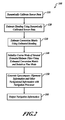
- FIGURE 2 is a flowchart of a method 100 of generating navigation output in accordance with the system 50 shown in FIGURE 1 .
- DCAL dynamic calibration
- this is performed by the input processing unit 70 on gyro and accelerometer data from the inertial measurement device sensors 60.
- data from the GPS receiver positioning device 64 is also calibrated.
- DCAL is described in more detail with reference to FIGURE 3 .
- heading is estimated using the calibrated sensor data. Estimation of heading is described in more detail with reference to FIGURE 4 .
- a body to local conversion matrix is initialized using the estimated heading.
- Initialization of the conversion matrix is described in more detail with reference to FIGURE 5 .
- a coarse mode of an iterated Kalman filter (IEKF) such as the IEKF 74
- the IEKF 74 is switched to fine mode.
- navigation processing is performed using the initialized IEKF 74.
- navigation output is generated based on the navigation processing. In one example, navigation processing is performed by the navigation processor 52 and output to the navigation display device 80.
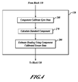
- FIGURE 3 is a flowchart showing additional detail for the block 110 shown in FIGURE 2 .
- accelerometer and gyro sensor data is averaged in real time to reduce noise in the information.
- the averaging is performed in two stages by the processing device 51.
- the data is averaged using a high data rate, such as 300Hz, 600Hz, or 1200Hz, for a duration of approximately one second for example.
- the data is averaged over a longer alignment period that varies depending on the sensors used in the navigation system 50.
- the alignment period may range from approximately 30 seconds to approximately 300 seconds, for example.
- gyro and accelerometer error is estimated by comparing the recorded sensor data with gravity and earth-rate values, such as those received from the gravitation input 68 and the earth-rate input 69, for example. Then, at a block 220, the estimated gyro and accelerometer error is corrected with known gravitation and earth rate values to generate compensated sensor data. For example, if the recorded sensor data was determined to be only 0.5 g for gravity, then the recorded data is multiplied by a compensation factor of 2 to generate a compensated gravity value.
- the compensated sensor data is output as calibrated sensor data.
- FIGURE 4 is a flowchart showing additional detail for the block 120 shown in FIGURE 2 .
- a component calibration of gyro data is performed. Since earth rate and latitude are constant for a stationery case, the z component and the x 2 + y 2 component can be calibrated separately.
- standard components are calculated using earth rate and latitude values. In one example, the standard components are calculated using the equation x 2 + y 2 and calibrated with earth rate * cos(latitude), where earth rate is the rate of rotation of the earth, and the z component is calibrated with earth rate * sin(latitude).
- the z component of the gyro value is earth-rate * sin(latitude).
- the "bias" or scale "factor” may be determined. Then, the real sensor data can be compensated to generate a more accurate value
- heading is estimated using the component calibrated sensor data.
- FIGURE 5 is a flowchart showing additional detail for the block 130 shown in FIGURE 2 .
- leveling is defined as the process of finding the angles of roll and pitch using accelerometer data from the inertial sensors 60 that is calibrated using gravity data from the gravitational input 68, while alignment is defined as the process of locating heading or yaw angle between body and local frames.
- ⁇ is a rotation vector:
- heading components are used to determine additional values in the body to local conversion matrix.
- C 11 cos ⁇ 3
- C 12 - sin ⁇ 3
- C 21 sin ⁇ 3
- C 22 cos ⁇ 3
- the body to local conversion matrix is initialized.
- C B ⁇ 2 ⁇ L cos ⁇ 3 sin ⁇ 3 - ⁇ 2 - sin ⁇ 3 cos ⁇ 3 ⁇ 1 ⁇ 2 ⁇ cos ⁇ 3 + ⁇ 1 ⁇ sin ⁇ 3 ⁇ 2 ⁇ sin ⁇ 3 + ⁇ 1 ⁇ cos ⁇ 3 1
- position information such as latitude and longitude may be received from a positioning device that does not depend on the Global Positioning System, a pilot, or another user.
- various combinations of the DCAL coarse mode ("real-time calibration") together with the inverse of the "trajectory generation engine", IEKF coarse mode, and IEKF fine mode may be used for gyro-compass alignment.
- the system and method may also be used to reduce gyro-compass alignment times for navigation systems using expensive IMUs in addition to those using inexpensive IMUs. Accordingly, the scope of the invention is not limited by the disclosure of the preferred embodiment. Instead, the invention should be determined entirely by reference to the claims that follow.
Landscapes
- Engineering & Computer Science (AREA)
- Radar, Positioning & Navigation (AREA)
- Remote Sensing (AREA)
- Physics & Mathematics (AREA)
- General Physics & Mathematics (AREA)
- Electromagnetism (AREA)
- Automation & Control Theory (AREA)
- Manufacturing & Machinery (AREA)
- Navigation (AREA)
Applications Claiming Priority (1)
| Application Number | Priority Date | Filing Date | Title |
|---|---|---|---|
| US11/838,811 US8024119B2 (en) | 2007-08-14 | 2007-08-14 | Systems and methods for gyrocompass alignment using dynamically calibrated sensor data and an iterated extended kalman filter within a navigation system |
Publications (2)
| Publication Number | Publication Date |
|---|---|
| EP2026037A2 true EP2026037A2 (fr) | 2009-02-18 |
| EP2026037A3 EP2026037A3 (fr) | 2011-09-28 |
Family
ID=40032502
Family Applications (1)
| Application Number | Title | Priority Date | Filing Date |
|---|---|---|---|
| EP08162274A Withdrawn EP2026037A3 (fr) | 2007-08-14 | 2008-08-12 | Système de navigation et son procédé correspondant pour alignement de boussole gyroscopique utilisant des données de capteur étalonné dynamiquement et un filtre Kalman étendu à itération |
Country Status (3)
| Country | Link |
|---|---|
| US (1) | US8024119B2 (fr) |
| EP (1) | EP2026037A3 (fr) |
| JP (1) | JP5237723B2 (fr) |
Cited By (12)
| Publication number | Priority date | Publication date | Assignee | Title |
|---|---|---|---|---|
| FR2944101A1 (fr) * | 2009-04-07 | 2010-10-08 | Thales Sa | Systeme inertiel hybride a comportement non lineaire et procede d'hybridation par filtrage multi hypotheses associe |
| CN102221366A (zh) * | 2011-03-11 | 2011-10-19 | 哈尔滨工程大学 | 一种基于模糊变地球自转角速度的快速精对准方法 |
| CN102853834A (zh) * | 2012-01-09 | 2013-01-02 | 北京信息科技大学 | 旋转载体用imu的高精度方案与消噪方法 |
| WO2014042710A3 (fr) * | 2012-05-31 | 2014-07-03 | International Electronic Machines Corporation | Estimation de pose |
| CN104075716A (zh) * | 2014-06-30 | 2014-10-01 | 南京理工大学 | 基于高精度imu的捷联惯导初始对准方法 |
| CN106405670A (zh) * | 2016-10-10 | 2017-02-15 | 北京航天控制仪器研究所 | 一种适用于捷联式海洋重力仪的重力异常数据处理方法 |
| CN110763252A (zh) * | 2019-09-24 | 2020-02-07 | 中国船舶重工集团公司第七0七研究所 | 一种基于嵌入式处理器的捷联惯导逆序滤波设计方法 |
| CN110887508A (zh) * | 2019-11-30 | 2020-03-17 | 航天科技控股集团股份有限公司 | 一种车载导航产品动态定位功能检测方法 |
| US10935392B2 (en) | 2015-09-11 | 2021-03-02 | Bae Systems Plc | Inertial sensor data correction |
| RU2749194C1 (ru) * | 2020-12-15 | 2021-06-07 | Общество с ограниченной ответственностью "Опытно-конструкторское бюро УЗГА" (ООО "ОКБ УЗГА") | Способ дистанционного определения координат местоположения наземного (надводного) объекта |
| CN116324336A (zh) * | 2020-10-30 | 2023-06-23 | 株式会社村田制作所 | Mems陀螺罗盘 |
| EP4549881A1 (fr) * | 2023-11-01 | 2025-05-07 | Honeywell International Inc. | Systèmes, appareils et procédés pour compenser une erreur d'installation de champ d'un dispositif tars |
Families Citing this family (46)
| Publication number | Priority date | Publication date | Assignee | Title |
|---|---|---|---|---|
| US7860617B1 (en) * | 2007-07-24 | 2010-12-28 | Lockheed Martin Corporation | Geosynchronous spacecraft autonomous navigation |
| DE102007045711A1 (de) * | 2007-09-24 | 2009-04-02 | Astrium Gmbh | Verfahren und Vorrichtung zur automatischen Bestimmung der Position von Transceivern von Navigationssignalen |
| US20130211723A1 (en) * | 2009-01-30 | 2013-08-15 | Gyrodata, Incorporated | Reducing error contributions to gyroscopic measurements |
| US8306726B2 (en) * | 2009-04-28 | 2012-11-06 | Caterpillar Inc. | Position monitoring system for a mobile machine |
| US20110039573A1 (en) * | 2009-08-13 | 2011-02-17 | Qualcomm Incorporated | Accessing positional information for a mobile station using a data code label |
| US8521428B1 (en) * | 2009-10-15 | 2013-08-27 | Moog Inc. | Heading determination using sensors mounted on rotatable assembly |
| US8209117B2 (en) * | 2009-12-03 | 2012-06-26 | Honeywell International Inc. | Method and system for latitude adaptive navigation quality estimation |
| US8855929B2 (en) * | 2010-01-18 | 2014-10-07 | Qualcomm Incorporated | Using object to align and calibrate inertial navigation system |
| JP5071533B2 (ja) * | 2010-05-19 | 2012-11-14 | 株式会社デンソー | 車両用現在位置検出装置 |
| US9229089B2 (en) | 2010-06-10 | 2016-01-05 | Qualcomm Incorporated | Acquisition of navigation assistance information for a mobile station |
| KR20120107433A (ko) * | 2011-03-21 | 2012-10-02 | 엘아이지넥스원 주식회사 | 디지털 mems 센서를 이용하는 고정밀 ins 모듈 및 그 구동 방법 |
| US8996195B2 (en) * | 2011-04-12 | 2015-03-31 | Georgia Tech Research Corporation | Systems and methods for derivative-free adaptive control |
| CN102721424B (zh) * | 2011-12-23 | 2015-03-25 | 北京理工大学 | 非完全自由度惯性平台关键参数多位置最优估计检测方法 |
| CN102865881B (zh) * | 2012-03-06 | 2014-12-31 | 武汉大学 | 一种惯性测量单元的快速标定方法 |
| US9008757B2 (en) | 2012-09-26 | 2015-04-14 | Stryker Corporation | Navigation system including optical and non-optical sensors |
| US9625262B2 (en) | 2012-10-25 | 2017-04-18 | Honeywell International Inc. | Smoothed navigation solution using filtered resets |
| US10309781B2 (en) | 2013-03-15 | 2019-06-04 | Intel Corporation | Computing a magnetic heading |
| US9483816B2 (en) | 2013-09-03 | 2016-11-01 | Litel Instruments | Method and system for high accuracy and reliability registration of multi modal imagery |
| US9903719B2 (en) | 2013-09-03 | 2018-02-27 | Litel Instruments | System and method for advanced navigation |
| WO2015165004A1 (fr) * | 2014-04-28 | 2015-11-05 | Intel Corporation | Estimation de cap servant à déterminer l'emplacement d'un utilisateur |
| CN103968834B (zh) * | 2014-05-09 | 2017-01-25 | 中国科学院光电技术研究所 | 一种近地停泊轨道上深空探测器的自主天文导航方法 |
| US9804288B2 (en) * | 2014-05-16 | 2017-10-31 | Baker Hughes, A Ge Company, Llc | Real-time, limited orientation sensor auto-calibration |
| US10401170B2 (en) | 2014-12-12 | 2019-09-03 | Honeywell International Inc. | Systems and methods for providing automatic detection of inertial sensor deployment environments |
| KR102280780B1 (ko) * | 2015-03-06 | 2021-07-22 | 삼성전자주식회사 | 모션 센서의 측정 정확도를 향상시키기 위한 전자 장치 및 그 방법 |
| US10048070B2 (en) * | 2015-04-17 | 2018-08-14 | Honeywell International Inc. | Transitioning from stationary alignment mode to in-motion alignment mode |
| CN104777469B (zh) * | 2015-04-21 | 2017-10-17 | 电子科技大学 | 一种基于量测误差协方差矩阵范数的雷达节点选择方法 |
| US9922570B2 (en) * | 2016-02-17 | 2018-03-20 | Ge Aviation Systems, Llc | Aircraft navigation performance prediction system |
| US10520317B2 (en) | 2016-06-02 | 2019-12-31 | Maliszewski Family 2001 Trust | In-situ wheel position measurement using inertial measurement units (IMUs) |
| US10101174B2 (en) | 2016-08-22 | 2018-10-16 | Rosemount Aerospace Inc. | Air data aided inertial measurement unit |
| GB2555806A (en) | 2016-11-09 | 2018-05-16 | Atlantic Inertial Systems Ltd | A navigation system |
| CN107764260A (zh) * | 2017-09-30 | 2018-03-06 | 湖南城市学院 | 一种卫星航迹定位系统 |
| CN108983795A (zh) * | 2018-05-07 | 2018-12-11 | 长江大学 | 一种三轴姿态校正方法及设备 |
| JP6516042B2 (ja) * | 2018-05-11 | 2019-05-22 | セイコーエプソン株式会社 | 信号処理装置、検出装置、センサー、電子機器及び移動体 |
| KR20200140449A (ko) * | 2019-06-05 | 2020-12-16 | 현대자동차주식회사 | 차량 및 그 제어방법 |
| FR3110534A1 (fr) * | 2020-05-19 | 2021-11-26 | Ixblue | Procédé de calcul d’un vecteur de vitesse instantanée d’un véhicule ferroviaire, système correspondant |
| US11754726B2 (en) * | 2020-07-13 | 2023-09-12 | Qualcomm Incorporated | Method and apparatus for in motion initialization of global navigation satellite system—inertial navigation system |
| US11879736B2 (en) * | 2020-09-11 | 2024-01-23 | Raytheon Company | Navigation integrity in GPS challenged environments |
| CN112066985B (zh) * | 2020-09-22 | 2022-08-09 | 峰飞航空科技(昆山)有限公司 | 一种组合导航系统初始化方法、装置、介质及电子设备 |
| CN113155156A (zh) * | 2021-04-27 | 2021-07-23 | 北京信息科技大学 | 运行信息的确定方法及装置、存储介质、电子装置 |
| DE102021004109A1 (de) | 2021-08-10 | 2021-09-30 | Daimler Ag | Verfahren und Vorrichtung zur Fusion von Sensordaten eines Fahrzeuges zur Visualisierung insbesondere für Augmented Reality-Anwendungen |
| CN113928327B (zh) * | 2021-09-29 | 2024-04-05 | 深圳市麦谷科技有限公司 | 一种三急事件的检测方法及系统 |
| US12601596B2 (en) * | 2021-10-07 | 2026-04-14 | L3Harris Technologies, Inc. | Estimation of target location and sensor misalignment angles |
| CN114162344A (zh) * | 2021-11-08 | 2022-03-11 | 陕西千山航空电子有限责任公司 | 一种飞机操纵系统数据标校装置 |
| EP4379322B1 (fr) * | 2022-11-29 | 2025-10-08 | Murata Manufacturing Co., Ltd. | Utilisation de drapeaux d'erreur de capteur pour l'estimation de données et l'estimation de fiabilité de données dans la navigation inertielle |
| CN119394333B (zh) * | 2024-11-14 | 2025-12-05 | 广州南方测绘科技股份有限公司 | 一种基于不变滤波的静基座精对准方法、系统、终端及存储介质 |
| CN120369008B (zh) * | 2025-06-25 | 2025-08-22 | 上海翊邀信息技术有限公司 | 一种融合惯导信息的车载北斗定位偏差自校准系统 |
Citations (3)
| Publication number | Priority date | Publication date | Assignee | Title |
|---|---|---|---|---|
| US20020008661A1 (en) | 2000-07-20 | 2002-01-24 | Mccall Hiram | Micro integrated global positioning system/inertial measurement unit system |
| US20020169553A1 (en) | 2001-05-11 | 2002-11-14 | Perlmutter Michael S. | Method and system for calibrating an IG/GP navigational system |
| US20050060093A1 (en) | 2003-09-05 | 2005-03-17 | Ford Thomas John | Inertial GPS navigation system using injected alignment data for the inertial system |
Family Cites Families (42)
| Publication number | Priority date | Publication date | Assignee | Title |
|---|---|---|---|---|
| US4783744A (en) * | 1986-12-08 | 1988-11-08 | General Dynamics, Pomona Division | Self-adaptive IRU correction loop design interfacing with the target state estimator for multi-mode terminal handoff |
| CA1321418C (fr) * | 1988-10-05 | 1993-08-17 | Joseph C. Mcmillan | Systeme de navigation terrestre pour l'arctique |
| US4954837A (en) * | 1989-07-20 | 1990-09-04 | Harris Corporation | Terrain aided passive range estimation |
| US5101356A (en) * | 1989-11-21 | 1992-03-31 | Unisys Corporation | Moving vehicle attitude measuring system |
| US5390125A (en) * | 1990-02-05 | 1995-02-14 | Caterpillar Inc. | Vehicle position determination system and method |
| US5051751A (en) | 1991-02-12 | 1991-09-24 | The United States Of America As Represented By The Secretary Of The Navy | Method of Kalman filtering for estimating the position and velocity of a tracked object |
| US5184304A (en) | 1991-04-26 | 1993-02-02 | Litton Systems, Inc. | Fault-tolerant inertial navigation system |
| US5272639A (en) * | 1992-01-14 | 1993-12-21 | Honeywell Inc. | Terrain referenced navigation electromagnetic-gravitational correlation |
| AU4159093A (en) | 1992-07-06 | 1994-01-13 | Monash University | Vehicle location system |
| US5296861A (en) * | 1992-11-13 | 1994-03-22 | Trimble Navigation Limited | Method and apparatus for maximum likelihood estimation direct integer search in differential carrier phase attitude determination systems |
| US5416712A (en) * | 1993-05-28 | 1995-05-16 | Trimble Navigation Limited | Position and velocity estimation system for adaptive weighting of GPS and dead-reckoning information |
| US5512904A (en) * | 1994-06-13 | 1996-04-30 | Andrew Corporation | Method and apparatus of establishing a vehicle azimuth |
| ZA957639B (en) | 1994-10-24 | 1996-05-24 | Caterpillar Inc | System and method for precisely determining an operating point for an autonomous vehicle |
| US5894323A (en) * | 1996-03-22 | 1999-04-13 | Tasc, Inc, | Airborne imaging system using global positioning system (GPS) and inertial measurement unit (IMU) data |
| US5784029A (en) | 1996-10-28 | 1998-07-21 | Motorola, Inc. | Recognition of and method and apparatus for GPS antenna lever arm compensation in integrated GPS/dead reckoning navigation systems |
| US6088653A (en) | 1996-12-31 | 2000-07-11 | Sheikh; Suneel I. | Attitude determination method and system |
| US6038498A (en) | 1997-10-15 | 2000-03-14 | Dassault Aviation | Apparatus and mehod for aircraft monitoring and control including electronic check-list management |
| EP0910023A2 (fr) | 1997-10-17 | 1999-04-21 | Siemens Aktiengesellschaft | Méthode et dispositif pour le modélisation neuromimétique d'un système dynamique avec un comportement non-linéaire stochastique |
| US6298316B1 (en) | 1998-05-18 | 2001-10-02 | Litton Systems, Inc. | Failure detection system |
| US6608589B1 (en) | 1999-04-21 | 2003-08-19 | The Johns Hopkins University | Autonomous satellite navigation system |
| US6175807B1 (en) * | 1999-06-09 | 2001-01-16 | Litton Systems, Inc. | Temperature compensation method for strapdown inertial navigation systems |
| GB9916482D0 (en) * | 1999-07-15 | 1999-09-15 | British Aerospace | Terrain navigation apparatus for a legged animal traversing terrain |
| US6459990B1 (en) * | 1999-09-23 | 2002-10-01 | American Gnc Corporation | Self-contained positioning method and system thereof for water and land vehicles |
| US6535821B2 (en) | 2000-02-11 | 2003-03-18 | University Of Iowa Research Foundation | System and method of bolus-chasing angiography with adaptive real-time computed tomography (CT) |
| US6417802B1 (en) * | 2000-04-26 | 2002-07-09 | Litton Systems, Inc. | Integrated inertial/GPS navigation system |
| US6631323B2 (en) | 2000-05-30 | 2003-10-07 | Northrop Grumman Corporation | Method and apparatus for improving performance of an inertial navigation system having global positioning system corrections |
| GB0013722D0 (en) | 2000-06-07 | 2001-03-14 | Secr Defence | Adaptive GPS and INS integration system |
| US6401036B1 (en) | 2000-10-03 | 2002-06-04 | Motorola, Inc. | Heading and position error-correction method and apparatus for vehicle navigation systems |
| US6433736B1 (en) | 2000-11-22 | 2002-08-13 | L-3 Communications Corp. | Method and apparatus for an improved antenna tracking system mounted on an unstable platform |
| US6577952B2 (en) * | 2001-01-08 | 2003-06-10 | Motorola, Inc. | Position and heading error-correction method and apparatus for vehicle navigation systems |
| US6754584B2 (en) * | 2001-02-28 | 2004-06-22 | Enpoint, Llc | Attitude measurement using a single GPS receiver with two closely-spaced antennas |
| US6826478B2 (en) | 2002-04-12 | 2004-11-30 | Ensco, Inc. | Inertial navigation system for mobile objects with constraints |
| US7124001B2 (en) * | 2003-07-11 | 2006-10-17 | The Boeing Company | Relative attitude estimator for multi-payload attitude determination |
| US7606665B2 (en) * | 2003-08-29 | 2009-10-20 | Honeywell International Inc. | System and method for employing an aided-alignment mode to align an inertial reference system |
| US20050114023A1 (en) * | 2003-11-26 | 2005-05-26 | Williamson Walton R. | Fault-tolerant system, apparatus and method |
| FR2866423B1 (fr) | 2004-02-13 | 2006-05-05 | Thales Sa | Dispositif de surveillance de l'integrite des informations delivrees par un systeme hybride ins/gnss |
| US7158882B2 (en) | 2004-03-01 | 2007-01-02 | Global Locate, Inc | Method and apparatus for locating position of a mobile receiver |
| US7509216B2 (en) * | 2004-03-29 | 2009-03-24 | Northrop Grumman Corporation | Inertial navigation system error correction |
| CA2565143C (fr) * | 2004-05-12 | 2014-07-08 | Northrop Grumman Corporation | Systeme et procede pour aligner des composants de navigation multiples |
| US7643939B2 (en) | 2006-03-08 | 2010-01-05 | Honeywell International Inc. | Methods and systems for implementing an iterated extended Kalman filter within a navigation system |
| US7739045B2 (en) * | 2006-05-31 | 2010-06-15 | Honeywell International Inc. | Rapid self-alignment of a strapdown inertial system through real-time reprocessing |
| US20080071476A1 (en) * | 2006-09-19 | 2008-03-20 | Takayuki Hoshizaki | Vehicle dynamics conditioning method on MEMS based integrated INS/GPS vehicle navigation system |
-
2007
- 2007-08-14 US US11/838,811 patent/US8024119B2/en not_active Expired - Fee Related
-
2008
- 2008-08-12 EP EP08162274A patent/EP2026037A3/fr not_active Withdrawn
- 2008-08-13 JP JP2008208622A patent/JP5237723B2/ja active Active
Patent Citations (3)
| Publication number | Priority date | Publication date | Assignee | Title |
|---|---|---|---|---|
| US20020008661A1 (en) | 2000-07-20 | 2002-01-24 | Mccall Hiram | Micro integrated global positioning system/inertial measurement unit system |
| US20020169553A1 (en) | 2001-05-11 | 2002-11-14 | Perlmutter Michael S. | Method and system for calibrating an IG/GP navigational system |
| US20050060093A1 (en) | 2003-09-05 | 2005-03-17 | Ford Thomas John | Inertial GPS navigation system using injected alignment data for the inertial system |
Cited By (17)
| Publication number | Priority date | Publication date | Assignee | Title |
|---|---|---|---|---|
| FR2944101A1 (fr) * | 2009-04-07 | 2010-10-08 | Thales Sa | Systeme inertiel hybride a comportement non lineaire et procede d'hybridation par filtrage multi hypotheses associe |
| EP2241856A1 (fr) * | 2009-04-07 | 2010-10-20 | Thales | Systeme inertiel hybride a comportement non lineaire et procede d'hybridation par filtrage multi hypotheses associe |
| US8229661B2 (en) | 2009-04-07 | 2012-07-24 | Thales | Hybrid inertial system with non-linear behaviour and associated method of hybridization by multi-hypothesis filtering |
| CN102221366A (zh) * | 2011-03-11 | 2011-10-19 | 哈尔滨工程大学 | 一种基于模糊变地球自转角速度的快速精对准方法 |
| CN102221366B (zh) * | 2011-03-11 | 2013-07-03 | 哈尔滨工程大学 | 一种基于模糊变地球自转角速度的快速精对准方法 |
| CN102853834A (zh) * | 2012-01-09 | 2013-01-02 | 北京信息科技大学 | 旋转载体用imu的高精度方案与消噪方法 |
| US9482536B2 (en) | 2012-05-31 | 2016-11-01 | International Electronic Machines Corp. | Pose estimation |
| WO2014042710A3 (fr) * | 2012-05-31 | 2014-07-03 | International Electronic Machines Corporation | Estimation de pose |
| CN104075716A (zh) * | 2014-06-30 | 2014-10-01 | 南京理工大学 | 基于高精度imu的捷联惯导初始对准方法 |
| US10935392B2 (en) | 2015-09-11 | 2021-03-02 | Bae Systems Plc | Inertial sensor data correction |
| CN106405670A (zh) * | 2016-10-10 | 2017-02-15 | 北京航天控制仪器研究所 | 一种适用于捷联式海洋重力仪的重力异常数据处理方法 |
| CN110763252A (zh) * | 2019-09-24 | 2020-02-07 | 中国船舶重工集团公司第七0七研究所 | 一种基于嵌入式处理器的捷联惯导逆序滤波设计方法 |
| CN110763252B (zh) * | 2019-09-24 | 2022-07-26 | 中国船舶重工集团公司第七0七研究所 | 一种基于嵌入式处理器的捷联惯导逆序滤波设计方法 |
| CN110887508A (zh) * | 2019-11-30 | 2020-03-17 | 航天科技控股集团股份有限公司 | 一种车载导航产品动态定位功能检测方法 |
| CN116324336A (zh) * | 2020-10-30 | 2023-06-23 | 株式会社村田制作所 | Mems陀螺罗盘 |
| RU2749194C1 (ru) * | 2020-12-15 | 2021-06-07 | Общество с ограниченной ответственностью "Опытно-конструкторское бюро УЗГА" (ООО "ОКБ УЗГА") | Способ дистанционного определения координат местоположения наземного (надводного) объекта |
| EP4549881A1 (fr) * | 2023-11-01 | 2025-05-07 | Honeywell International Inc. | Systèmes, appareils et procédés pour compenser une erreur d'installation de champ d'un dispositif tars |
Also Published As
| Publication number | Publication date |
|---|---|
| US8024119B2 (en) | 2011-09-20 |
| US20090048779A1 (en) | 2009-02-19 |
| JP2009098125A (ja) | 2009-05-07 |
| EP2026037A3 (fr) | 2011-09-28 |
| JP5237723B2 (ja) | 2013-07-17 |
Similar Documents
| Publication | Publication Date | Title |
|---|---|---|
| US8024119B2 (en) | Systems and methods for gyrocompass alignment using dynamically calibrated sensor data and an iterated extended kalman filter within a navigation system | |
| EP1837627B1 (fr) | Procédés et systèmes pour mettre en oeuvre un filtre Kalman étendu itéré au sein d'un système de navigation | |
| US10877059B2 (en) | Positioning apparatus comprising an inertial sensor and inertial sensor temperature compensation method | |
| EP3408688B1 (fr) | Gnss et système de navigation inertiel utilisant le lacet relatif comme variable observable pour un filtre ins | |
| JP5398120B2 (ja) | Gps複合航法装置 | |
| US10533856B2 (en) | Navigation system utilizing yaw rate constraint during inertial dead reckoning | |
| US9568321B2 (en) | Systems and methods for determining inertial navigation system faults | |
| US8185309B2 (en) | Enhanced inertial system performance | |
| KR100443550B1 (ko) | 오차보정시스템을 구비하는 관성측정유닛-지피에스통합시스템과 미지정수 검색범위 축소방법 및 사이클 슬립검출방법, 및 그를 이용한 항체 위치, 속도,자세측정방법 | |
| US20080082266A1 (en) | Multipath Modeling For Deep Integration | |
| JP5119967B2 (ja) | 測位方法、プログラム及び測位装置 | |
| KR20230148346A (ko) | 칼만 필터를 사용하여 적어도 하나의 시스템 상태를 결정하는 방법 | |
| JP6248559B2 (ja) | 車両用走行軌跡算出装置 | |
| Falletti et al. | The Kalman filter and its applications in GNSS and INS | |
| KR20220099313A (ko) | 고신뢰성 통합 내장형 복합항법 시스템 | |
| US20250389537A1 (en) | Computer-implemented methods for attitude determination of an aircraft for navigation | |
| KARTHIKA et al. | Development Of Error Compensation Method And Algorithm In Dead Reckoning For Improving Precision Of GPS Navigation | |
| Zanutta et al. | Host-based Tight-integration of MEMS Dead-Reckoning and GPS |
Legal Events
| Date | Code | Title | Description |
|---|---|---|---|
| PUAI | Public reference made under article 153(3) epc to a published international application that has entered the european phase |
Free format text: ORIGINAL CODE: 0009012 |
|
| 17P | Request for examination filed |
Effective date: 20080812 |
|
| AK | Designated contracting states |
Kind code of ref document: A2 Designated state(s): AT BE BG CH CY CZ DE DK EE ES FI FR GB GR HR HU IE IS IT LI LT LU LV MC MT NL NO PL PT RO SE SI SK TR |
|
| AX | Request for extension of the european patent |
Extension state: AL BA MK RS |
|
| PUAL | Search report despatched |
Free format text: ORIGINAL CODE: 0009013 |
|
| AK | Designated contracting states |
Kind code of ref document: A3 Designated state(s): AT BE BG CH CY CZ DE DK EE ES FI FR GB GR HR HU IE IS IT LI LT LU LV MC MT NL NO PL PT RO SE SI SK TR |
|
| AX | Request for extension of the european patent |
Extension state: AL BA MK RS |
|
| RIC1 | Information provided on ipc code assigned before grant |
Ipc: G01C 25/00 20060101ALI20110823BHEP Ipc: G01C 21/16 20060101AFI20110823BHEP |
|
| 17Q | First examination report despatched |
Effective date: 20110919 |
|
| AKX | Designation fees paid |
Designated state(s): DE FR GB IT |
|
| RAP1 | Party data changed (applicant data changed or rights of an application transferred) |
Owner name: HONEYWELL INTERNATIONAL INC. |
|
| STAA | Information on the status of an ep patent application or granted ep patent |
Free format text: STATUS: THE APPLICATION IS DEEMED TO BE WITHDRAWN |
|
| 18D | Application deemed to be withdrawn |
Effective date: 20180612 |