EP2068120A1 - Mobiles Tracking - Google Patents
Mobiles Tracking Download PDFInfo
- Publication number
- EP2068120A1 EP2068120A1 EP07122318A EP07122318A EP2068120A1 EP 2068120 A1 EP2068120 A1 EP 2068120A1 EP 07122318 A EP07122318 A EP 07122318A EP 07122318 A EP07122318 A EP 07122318A EP 2068120 A1 EP2068120 A1 EP 2068120A1
- Authority
- EP
- European Patent Office
- Prior art keywords
- data
- wireless communications
- communications device
- current position
- path
- Prior art date
- Legal status (The legal status is an assumption and is not a legal conclusion. Google has not performed a legal analysis and makes no representation as to the accuracy of the status listed.)
- Granted
Links
Images


Classifications
-
- G—PHYSICS
- G01—MEASURING; TESTING
- G01C—MEASURING DISTANCES, LEVELS OR BEARINGS; SURVEYING; NAVIGATION; GYROSCOPIC INSTRUMENTS; PHOTOGRAMMETRY OR VIDEOGRAMMETRY
- G01C21/00—Navigation; Navigational instruments not provided for in groups G01C1/00 - G01C19/00
- G01C21/26—Navigation; Navigational instruments not provided for in groups G01C1/00 - G01C19/00 specially adapted for navigation in a road network
- G01C21/34—Route searching; Route guidance
- G01C21/3407—Route searching; Route guidance specially adapted for specific applications
- G01C21/3438—Rendezvous; Ride sharing
-
- G—PHYSICS
- G08—SIGNALLING
- G08G—TRAFFIC CONTROL SYSTEMS
- G08G1/00—Traffic control systems for road vehicles
- G08G1/09—Arrangements for giving variable traffic instructions
- G08G1/0962—Arrangements for giving variable traffic instructions having an indicator mounted inside the vehicle, e.g. giving voice messages
- G08G1/0968—Systems involving transmission of navigation instructions to the vehicle
- G08G1/096805—Systems involving transmission of navigation instructions to the vehicle where the transmitted instructions are used to compute a route
- G08G1/096827—Systems involving transmission of navigation instructions to the vehicle where the transmitted instructions are used to compute a route where the route is computed onboard
-
- G—PHYSICS
- G08—SIGNALLING
- G08G—TRAFFIC CONTROL SYSTEMS
- G08G1/00—Traffic control systems for road vehicles
- G08G1/09—Arrangements for giving variable traffic instructions
- G08G1/0962—Arrangements for giving variable traffic instructions having an indicator mounted inside the vehicle, e.g. giving voice messages
- G08G1/0968—Systems involving transmission of navigation instructions to the vehicle
- G08G1/096833—Systems involving transmission of navigation instructions to the vehicle where different aspects are considered when computing the route
- G08G1/096844—Systems involving transmission of navigation instructions to the vehicle where different aspects are considered when computing the route where the complete route is dynamically recomputed based on new data
-
- G—PHYSICS
- G08—SIGNALLING
- G08G—TRAFFIC CONTROL SYSTEMS
- G08G1/00—Traffic control systems for road vehicles
- G08G1/09—Arrangements for giving variable traffic instructions
- G08G1/0962—Arrangements for giving variable traffic instructions having an indicator mounted inside the vehicle, e.g. giving voice messages
- G08G1/0968—Systems involving transmission of navigation instructions to the vehicle
- G08G1/096855—Systems involving transmission of navigation instructions to the vehicle where the output is provided in a suitable form to the driver
- G08G1/096861—Systems involving transmission of navigation instructions to the vehicle where the output is provided in a suitable form to the driver where the immediate route instructions are output to the driver, e.g. arrow signs for next turn
-
- G—PHYSICS
- G08—SIGNALLING
- G08G—TRAFFIC CONTROL SYSTEMS
- G08G1/00—Traffic control systems for road vehicles
- G08G1/09—Arrangements for giving variable traffic instructions
- G08G1/0962—Arrangements for giving variable traffic instructions having an indicator mounted inside the vehicle, e.g. giving voice messages
- G08G1/0968—Systems involving transmission of navigation instructions to the vehicle
- G08G1/096855—Systems involving transmission of navigation instructions to the vehicle where the output is provided in a suitable form to the driver
- G08G1/096866—Systems involving transmission of navigation instructions to the vehicle where the output is provided in a suitable form to the driver where the complete route is shown to the driver
-
- G—PHYSICS
- G08—SIGNALLING
- G08G—TRAFFIC CONTROL SYSTEMS
- G08G1/00—Traffic control systems for road vehicles
- G08G1/09—Arrangements for giving variable traffic instructions
- G08G1/0962—Arrangements for giving variable traffic instructions having an indicator mounted inside the vehicle, e.g. giving voice messages
- G08G1/0968—Systems involving transmission of navigation instructions to the vehicle
- G08G1/096855—Systems involving transmission of navigation instructions to the vehicle where the output is provided in a suitable form to the driver
- G08G1/096872—Systems involving transmission of navigation instructions to the vehicle where the output is provided in a suitable form to the driver where instructions are given per voice
-
- G—PHYSICS
- G08—SIGNALLING
- G08G—TRAFFIC CONTROL SYSTEMS
- G08G1/00—Traffic control systems for road vehicles
- G08G1/09—Arrangements for giving variable traffic instructions
- G08G1/0962—Arrangements for giving variable traffic instructions having an indicator mounted inside the vehicle, e.g. giving voice messages
- G08G1/0968—Systems involving transmission of navigation instructions to the vehicle
- G08G1/096877—Systems involving transmission of navigation instructions to the vehicle where the input to the navigation device is provided by a suitable I/O arrangement
- G08G1/096883—Systems involving transmission of navigation instructions to the vehicle where the input to the navigation device is provided by a suitable I/O arrangement where input information is obtained using a mobile device, e.g. a mobile phone, a PDA
-
- G—PHYSICS
- G08—SIGNALLING
- G08G—TRAFFIC CONTROL SYSTEMS
- G08G1/00—Traffic control systems for road vehicles
- G08G1/16—Anti-collision systems
- G08G1/161—Decentralised systems, e.g. inter-vehicle communication
- G08G1/163—Decentralised systems, e.g. inter-vehicle communication involving continuous checking
Definitions
- the present disclosure relates generally to wireless communications devices and, in particular, to wireless communications devices having Global Positioning System (GPS) receivers or other such positioning-determining capabilities.
- GPS Global Positioning System
- Some wireless communications devices have Global Positioning System (GPS) chipsets (or external Bluetooth TM accessories) that convert radio-frequency signals received from orbiting GPS satellites into real-time coordinates of longitude and latitude that are typically accurate to within a few meters of the actual current location of the device.
- GPS Global Positioning System
- the current location i.e. the coordinates of longitude and latitude
- the current location can then be transmitted wirelessly to a recipient who has another wireless communications device (or via cellular base station and Internet to any other networked computing device) to thereby enable the recipient to map the coordinates using any one of a number of available mapping applications such as BlackBerry Maps TM , Google Maps TM or TeleNavTM.
- FIG. 1 is a flowchart outlining steps of a method of generating and transmitting speed, time and path data to enable a first wireless communications device to track a second wireless communications device;
- FIG. 2 is a block diagram of key components of a GPS-enabled wireless communications device on which the present technology can be implemented;
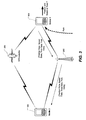
- FIG. 3 is a high-level system diagram depicting operation of the present tracking technology
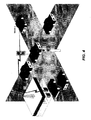
- FIG. 4 depicts a common scenario, which is presented merely by way of example, in which a first mobile user would utilize the present tracking technology to enable a second mobile user, who has been left behind at a traffic light, to follow the first mobile user;
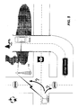
- FIG. 5 depicts the problem, arising out of the example scenario of FIG. 4 , in which the second mobile user is left trying to guess which is the proper route to take to follow the first mobile user when only current location updates are provided periodically to the second mobile user;
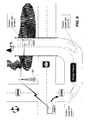
- FIG. 6 depicts how a method of generating and transmitting speed, time and path data enables the second mobile user to determine the proper route to the first mobile user;
- FIG. 7 depicts an example of a map application displayed on a wireless communications device of a mobile user who is tracking another mobile user;
- FIG. 8 depicts an example of an options page within a "Tracking Manager” module or application in which the user of the tracking device can configure various settings and preferences associated with the tracking function
- FIG. 9 depicts an example of an options page within a "Follow-Me Manager" module or application in which the user of the device to be followed can configure various settings and preferences associated with the tracking function.
- the present technology preferably generally provides a method, wireless communications device and computer program product that enable tracking of a wireless communications device.
- this technology may enable a user of a first wireless communications device to track or follow a second wireless communications device by receiving not only current position data representing the current position of the second device, but also one or more of speed data, time data or path data indicative, respectively, of the speed of the device, the time corresponding to the current position, and the path (or route) that the device has taken from its previously transmitted position to its current position.
- an aspect of the present technology is preferably a method of tracking a wireless communications device using another computing device.
- the method may comprise steps of obtaining current position data for the first wireless communications device, obtaining one or more of speed data, time data, and path data for the first wireless communications device, and transmitting the current position data and at least one of the speed data, time and path data from the wireless communications device to the other computing device to enable tracking of the wireless communications device using the computing device.
- the computing device may be a second wireless communications device so that a first wireless communications device is used to track a second wireless communications device.
- Another aspect of the present technology may be a computer program product that includes code adapted to perform the steps of the foregoing method when the computer program product is loaded into memory and executed on a processor of a wireless communications device.
- the code could be loaded onto a server that is adapted to receive the raw device data from the first mobile device, process the data to create useful route-tracking information, e.g. waypoints, and then transmit the information (processed data) to the second mobile device.
- Yet another aspect of the present technology may be a wireless communications device for generating and transmitting data to enable tracking of the device.
- the device may have a GPS chipset for receiving GPS signals and for generating current position data representing a current position of the device, a memory operatively connected to a processor for storing and executing an application configured to obtain one or more of speed data, time data and path data for the device, and a radiofrequency transmitter for transmitting the current position data in addition to at least one of the speed data, the time data and the path data.
- the computing device may have a communications port for receiving current position data representing a current position of the mobile device in addition to at least one of speed data, time data and path data associated with the mobile device, a memory operatively connected to a processor for storing and executing a mapping application for generating a map on which the current position is mapped, and a display for displaying the map in addition to the one or more of the speed data, the time data, and the path data.
- FIG. 1 is a flowchart outlining steps of a method of generating and transmitting speed, time and path data to enable a first wireless communications device to track a second wireless communications device.
- tracking of one device by another is initiated. This will be known herein as enabling or activating "follow-me” mode.
- Activating "follow-me” mode may be done by either the first device or by the second device, and it may be done either manually or automatically.
- Automatic triggering of tracking mode can be done using a proximity detection subsystem that detects when one device has strayed away from another device with which it has been paired. Bluetooth TM proximity detection can be used to accomplish this. When one Bluetooth TM device strays away from its paired device, then connectivity is lost, which can thus be used to automatically trigger the activation of tracking/follow-me mode.
- the first wireless communications device obtains, at step 12, current position data representing the current position (location) of the device.
- Current position data can be obtained using an onboard GPS chipset receiver or an external BluetoothTM-enabled GPS puck. GPS signals from multiple orbiting GPS satellites provide a position fix accurate to within a few meters. Assisted GPS technologies and Aided GPS technologies can also be used to increase the time-to-first-fix (TTFF). Position data can also be obtained or supplemented using by radiolocation techniques involving triangulation of base station signals and time of arrival calculations, though these techniques are less accurate than GPS, which provides sufficient accuracy for road-based navigation.
- TTFF time-to-first-fix
- the method also entails a step 14 of determining which additional data types to obtain and transmit.
- one or more of speed data, time data and path data is obtained and transmitted as well.
- seven options (16-28) are presented in FIG. 1 : option 16: obtaining all data types (i.e. speed, time and path data); option 18: obtaining only speed and time data; option 20: obtaining only speed and path data; option 22: obtaining only time and path data; option 24: obtaining only speed data; option 26: obtaining only time data; and option 28: obtaining only path data.
- the "tracking data" includes not only GPS position data but also one or more of the speed data, time data and path data.
- the tracking data can also include bearing (direction of travel).
- new (updated) position, speed, time and path data is obtained and transmitted by repeating steps 12-30.
- the characteristics and attributes of the speed, time and path data will be elaborated in greater detail below with regard to FIG. 3 .
- this additional tracking data facilitates the task of tracking or following another mobile device. Due to the time lag between static current position data points, it is sometimes very difficult to determine which route to take to follow the lead device.
- Providing speed, time and path data in addition to current position data provides the second mobile user (i.e. the follower or tracking party) a better overall picture of the movements of the first mobile user. This makes it much easier for the second mobile user to not only retrace the first mobile user's exact route, but also to (possibly) predict or anticipate where the second mobile device is headed.
- the foregoing method steps can be implemented as coded instructions in a computer program product.
- the computer program product is a computer-readable medium upon which software code is recorded to perform the foregoing steps when the computer program product is loaded into memory and executed on the microprocessor of the wireless communications device.
- This novel method is preferably implemented on a wireless communications device such as the BlackBerry® by Research in Motion Limited (or on other wireless handhelds, cellular phones, wireless-enabled laptops or wireless-enabled PDAs).
- a wireless communications device such as the BlackBerry® by Research in Motion Limited (or on other wireless handhelds, cellular phones, wireless-enabled laptops or wireless-enabled PDAs).
- FIG. 2 is a block diagram depicting certain key components of a wireless communications device 100. It should be expressly understood that this figures is intentionally simplified to show only certain components; the device 100 of course includes other components beyond what are shown in FIG. 2 .
- the device 100 includes a microprocessor 102 (or simply a "processor") which interacts with memory in the form of RAM 104 and flash memory 106, as is well known in the art.
- the device 100 includes an RF transceiver 108 for communicating wirelessly with one or more base stations 200.
- the device 100 includes a GPS receiver chipset 110 for receiving GPS radio signals transmitted from one or more orbiting GPS satellites 300.
- the device 100 typically includes a display 112 (e.g.
- the processor and memory thus enable a map application (among other software applications) to run on the wireless device.
- the map application can interact with the GPS receiver 110 by mapping GPS position coordinates so as to graphically display the current location of a device.
- FIG. 3 is a high-level system diagram depicting operation of the present tracking technology.
- two GPS-enabled wireless communications devices 100 are in communication with each via base station 200 or via separate base stations if the devices are further apart.
- the devices are connected to each other via a wireless network enabling transmission and reception of data packets.
- the wireless communications devices 100 are in receipt of GPS signals from a plurality of GPS satellites 300.
- the lead device "Mobile 1" (which is associated with the first mobile user) obtains and transmits current position data, speed data, time data and path data (or a subset thereof) to the device of the second mobile user ("Mobile 2") via base station 200 (and its wireless network).
- Mobile 2 receives this current position data, speed data, time data and path data (or a subset thereof) and then presents this "tracking data" to the second mobile user graphically and/or audibly.
- the second wireless communications device can map the current position and path with superimposed speed and time information of the first mobile user on a map, as will be shown by way of example below in FIG. 7 .
- the tracking data can be presented audibly such as in the form of audible reports (e.g. "The party you are following was 2 minutes ago at the corner of 1 st Avenue and Bank Street, traveling eastbound on 1 st Avenue at 50 km/h") and/or as turn-by-turn instructions to navigate the same path as taken by the first mobile user.
- the second mobile device receives its own GPS signals and converts these into its own GPS fix. Its own current position can be plotted on the map to show relative positions.
- its own current position fix can be used by navigation software to reroute the second mobile user over a different path to catch up to the first mobile user.
- navigation software can be used to determine a more optimal route to reach the most recently received current position of the first mobile user and to present this option to the second mobile user, who may either choose to follow the exact path taken by the first mobile user or to take the suggested, "more optimal" route to catch up to the first mobile user.
- speed data means data pertaining to the speed, velocity or rate of travel of the device being followed.
- the speed data can be an average speed determined using the rate of change of (GPS-determined) position over time.
- speed data can be an instantaneous velocity obtained using a velocity sensor/transducer that is embedded or connected to the device.
- the device may receive speed data wirelessly (e.g. via Bluetooth TM from a vehicle speed sensor).
- the speed data may include the speed as a scalar value (just the magnitude) or it may include a velocity vector (both speed and direction). Where path data is also provided, the velocity vector is unnecessary since direction is already known from the path data).
- Speed data is useful to the recipient (second mobile user) to know how fast the first mobile user is traveling, and thus whether he should consider traveling faster to catch up.
- time data means data pertaining to the actual time of day of the first mobile device when it is at a particular location or the time elapsed since the last position fix or the time elapsed between the position fix and the receipt of the tracking data by the second mobile user.
- time data accompanying the GPS position fix gives important context to the location data by telling the recipient (the second mobile user) that the first mobile user was at that particular location at that particular time.
- time data enables the recipient to know how old or stale the position fix really is.
- path data means data pertaining to the path or route that the first mobile device has taken. This can be provided as path segments (just the portion of the path that the device has travelled since the previously fix was obtained) or as a cumulative path that shows the entire path the device has travelled since tracking was initiated.
- the receiving device can store all the path data but only display the cumulative path data that fits within the bounding box of at the map scale selected.
- the path data may include a sequential list of all street names and highway numbers that define the path taken by the lead device along with the direction taken along each one, thus constituting navigation instructions for the recipient.
- the path data can be vector data that enables the recipient device to render a map of the path with the path highlighted using one of any number of standard mapping applications.
- a bitmap showing the route/path highlighted can be generated by the lead device and transmitted to the recipient device for immediate viewing onscreen.
- the efficiency of this tracking method or following method can be improved by simplifying the path data to reduce the amount of data being generated and transmitted without unduly sacrificing travel path fidelity.
- Techniques such as the Douglas Peuker line simplification algorithm can be used to reduce the number of points required to describe a path (e.g. by eliminating common points along a straight line).
- the path data effectively subsumes the current position data because the destination point of each path segment of the path data corresponds to each of the position fixes.
- the path data is presented as a graphically highlighted route on a map (with optional navigation instructions presented either graphically or audibly).
- the current position fix is thus used to define the endpoint or destination of the path.
- the second mobile device may optionally present the destination of the path (which is defined by the GPS position fix) either as a destination street address (e.g. 123 Main Street) and/or as longitude and latitude coordinates.
- the second mobile device could also optionally present a distance to the first mobile device.
- This distance could be in terms of actual road distance in kilometres (or miles) or meters (or yards).
- the distance could alternatively be presented in terms of straight-line distance (the distance "as a crow flies") along with the compass bearing (e.g. "northeast” or 045 degrees).
- an estimated time (estimated time of arrival") to the current location of the first mobile user can be provided or the time to convergence can be presented (the time required to catch up to the first mobile user or to arrive within a prescribed range of the first user, such as, for example, the range at which the Bluetooth TM proximity detection was triggered).
- a "trip computer" module can be provided as a software application on the device to compute various distances, compass bearings and times.
- FIG. 4 depicts a common scenario, which is presented merely by way of example, in which a first mobile user (“Mobile 1”) would utilize the present tracking technology to enable a second mobile user (“Mobile 2”), who has been left behind at a traffic light, to follow the first mobile user.
- the present technology is particularly useful for mobile users travelling in road vehicles where the speeds involved, the volume of traffic on the roads, the interference of traffic lights, and the number of routing options make it is easy to lose track of the vehicle being followed.
- cars are depicted by way of example, the scenario described with regard to this and the following figures is equally applicable to other road vehicles (e.g. trucks, vans, buses, motorcycles, scooters), or to off-road vehicles (e.g. snowmobiles, ATVs), or to watercraft (e.g. motorboats, yachts, sailboats, personal watercraft, jet skis) or to bicyclists or even to mobile users who are merely walking on foot.
- road vehicles e.g. trucks, vans, buses, motorcycles, scooter
- FIG. 5 depicts the problem, arising out of the example scenario of FIG. 4 , in which the second mobile user (“Mobile 2") is left trying to guess which is the proper route to take to follow the first mobile user ("Mobile 1") when only current location updates are provided periodically to the second mobile user.
- the car associated with Mobile 1 is no longer within visual range of the car associated with Mobile 2 (having been left behind earlier on at a traffic light). Therefore, the occupants of the car associated with Mobile 2 would not necessarily know which way to go (presuming, for the sake of illustration, that the occupants of the car associated with Mobile 2 do not know the proper route to take to reach the park by the lake).
- FIG. 6 depicts how a method of generating and transmitting speed, time and path data enables the second mobile user ("Mobile 2") to determine the proper route to the first mobile user "Mobile 1").
- Mobile 2 the second mobile user
- Mobile 1 three data transmissions are provided by Mobile 1 to Mobile 2 at discrete points to enable Mobile 2 to follow Mobile 1.
- the path data for example, might be a pre-generated bitmap (or vector path data enabling rendering of a map) showing a segment of Highway 17 followed by an exit onto Highway 206S.
- Turn-by-turn navigation instructions in graphical or audible form could also be provided.
- T2 when Mobile 1 turns onto the bridge, another transmission of tracking data is sent, again providing an update of the current position of Mobile 1 along with its updated speed, time and path.
- Mobile 1 transmits updated position, speed, time and path data to Mobile 2.
- the three data transmissions provide Mobile 2 with enough information to enable Mobile 2 to correctly exit onto Highway 206S, to correctly turn onto Bridge Street and to correctly follow the bridge over the lake to the park which is the destination that Mobile 1 intended.
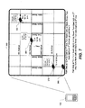
- FIG. 7 depicts an example of a map application displayed on a wireless communications device of a mobile user who is tracking another mobile user.
- An application interface 350 is provided merely by way of example to illustrate one manner of presenting the tracking data. As will be readily appreciated, other interfaces presenting the data in other manners, i.e. having a different "look and feel" would be of course be possible. Likewise, the interface could present more data or less data than what is shown in this example.
- audible reports can be used to supplement or replace certain aspects of the tracking data, e.g. using text-to-speech turn-by-turn navigation that read aloud the street names, audibly reporting speed, time and position data in addition to displaying it onscreen.
- the current location of the tracking party is shown by a car icon 360 (although other icons can be selected by the user to fit the circumstance).
- Car icon 370 represents the GPS position fix at time T1 of the first mobile user that the second mobile user is tracking as soon as tracking/follow-me mode is initiated.
- Car icon 380 represents the updated position at time T2 which, in this example, is five minutes later at 12:10 pm (although it should be appreciated that updates can be provided more frequently, e.g. once per minute) or less frequently, as configured by the users. Less frequent updates can be provided in rural environments where the routing options are fewer and where the users desire to conserve device resources for other uses or applications. More frequent updates would of course be useful in densely populated urban areas where the number of route choices are high and thus the likely of getting lost is higher.
- the frequency of updates can also be managed or modulated based on the state of the leading user (first mobile user) and the distance between the first mobile user and the second mobile user (the following party).
- updates may be sent less frequently if the lead user (first mobile user) is (a) stopped; (b) travelling at high speed in a constant direction; or (c) a large distance from the following vehicle (which require feedback from the tracking party/second mobile user). Sending updates less frequently reduces the burden on the mobile devices and on the wireless link.
- path data can be more easily compressed if it is sent in larger segments.
- the rate of travel (i.e. speed) of the lead user (first mobile user) can also be an important factor in determining whether there is a latency effect in the process of generating, transmitting, receiving and displaying the path data.
- the method should take this latency or delay into account by anticipating or predicting where the first mobile user (lead user) is likely to be, or where the lead user is heading, at the time the path data is actually displayed onscreen on the device of the second mobile user.
- the path data would provide a route as shown between car icons 370 and 380, i.e. the route traversed between times T1 and T2.
- Written instructions and/or audible instructions would provide turn-by-turn navigation, e.g. "Go East on 1st Ave, Turn North (left) on Bank Street, Turn East (right) on 3rd Avenue, go past Hwy 1.”
- a third update is provided to the second mobile user by transmitting updated tracking data at time T3, whose position is represented by car icon 390.
- the path data would update the route as shown between car icons 380 and 390 and would optionally also provide navigation instructions in written or audible format, e.g. "Turn South (right) on Oak Street, Turn East (left) on 2nd Ave, Turn North (left) on Maple Street. Turn east (right) on 4th Ave.”
- the path, speed and time data facilitate the second mobile user's task of following the first mobile user through the city streets.
- the application may optionally compute an alternate route (e.g. east on 1 st Avenue and left on Alder) rather than slavishly follow the exact path taken by the first mobile user.
- the second mobile user may be presented with a choice between the exact route and the alternate route or the user may configure the device to automatically provide either the exact route or the alternate route (where the alternate route is shorter).
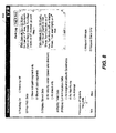
- FIG. 8 depicts an example of an options page 400 within a "Tracking Manager" module or application in which the user of the tracking device (the second mobile user) can configure various settings and preferences associated with the tracking function.
- the options page 400 enables the user to activate or deactivate the tracking function, to determine which types of data are to be displayed and in what particular format.
- the user can also specify the frequency with which updates requests are sent to the device belonging to the first mobile user being followed.
- the user can also specify whether he prefers to receive pre-generated bitmaps (i.e. bitmaps generated by the first mobile user on his device) or to receive the raw data which is then to be mapped by the receiving device.
- An optional path log can be provided to enable the user to review or revisit all of the navigation instructions acquired while following the first mobile user along the various path segments.
- An optional "Map It Now" function will bring up a map with the paths highlighted or otherwise emphasized.
- a breadcrumb path (composed of waypoints or path segments) can also be stored (along with optional reverse navigation instructions) to enable the user to retrace his path to return to the starting point where the following began.
- This breadcrumb function and/or set of reverse path instructions is particularly useful in situations when the second mobile user has followed the first mobile user through unfamiliar places and then wishes to return alone (unguided) to the point of where the following originated. For example, consider the scenario where the second mobile user has followed the first mobile user to a cottage through unfamiliar terrain and then wishes to return home alone after dark. The user activates the breadcrumb function to obtain the route home without having to worry about trying to navigate unfamiliar roads in the dark.
- the breadcrumb function can also include stored travel times to inform the user of how much time it took to travel between the waypoints when following the first mobile user.
- the breadcrumb function can also optionally provide distances (audibly or graphically) and travel speeds for each path segment between waypoints. This is useful for the user to know what speed is reasonable to travel (when perhaps speed limits are not easily visible) and how many kilometres or miles he has to travel to the next waypoint.
- the breadcrumb function can also optionally re-compute the travel time to the next waypoint based on the actual travel speed on the return leg of the voyage (which may happen to differ from the travel speed for the first leg of the voyage).
- another breadcrumb function that can be implemented is an off-road breadcrumb function which is usable in scenarios where the lead user (first mobile user) is not traveling on roads known to the navigation software, in which case breadcrumbs or waypoints are defined at specific positions to enable the tracking party to follow the same path or paths taken by the lead user.
- the device can be configured to record audible input from the user (via the microphone on the device) that thereby enables the user to comment on personally defined waypoints.
- This recorded waypoint commentary can be stored in association with an actual GPS position fix (or an interpolated position between adjacent fixes based on travel time and travel speed).
- the waypoint commentary is played audibly via the device speaker to remind the user of landmarks or waypoints that are personally meaningful.
- the user may record "We are turning at a bright orange gas station by a McDonald's.” Recording may be voice-activated (hands-free) or triggered by saying a predetermined specific word or phrase like "Record Waypoint Comment" that voice-recognition software on the device recognizes. When the user returns, the waypoint comment is played through the speaker to alert the user of the particular waypoint that he considered meaningful.
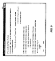
- FIG. 9 depicts an example of an options page 500 within a "Follow-Me Manager" module or application in which the user of the device to be followed can configure various settings and preferences associated with the tracking function.
- the follow-me manager enables the user of the device being followed (the first mobile user) to manually enable the follow-me mode, to automatically trigger the follow-me mode based on Bluetooth TM proximity detection (loss of Bluetooth TM connectivity), or to disable follow-me mode (to refuse to receive tracking data).
- Bluetooth TM proximity detection loss of Bluetooth TM connectivity
- follow-me mode to refuse to receive tracking data.
- Bluetooth TM proximity detection can also be used to signal availability to enter into follow-me mode.
- the BluetoothTM-enabled device sends a signal indicating that it is ready and available to "pair" with another Bluetooth TM device. For example, if first and second mobile users are planning to meet up so that one can follow the other, the two users put their devices into “discoverable” mode in order to allow the two devices to pair up when they have come suitably within range, e.g. up to approximately 100 meters for a Class I Bluetooth TM device, or alternatively, to within 10 meters for a Class II device.
- the data exchanged can be accomplished using the Bluetooth TM connection (for Class I devices) although due to the limited range (100 m), it is preferable to rely on the wireless link.
- the device could use the Bluetooth TM link and then switch over to the cellular channel (the "normal" wireless link) when the devices get close to their maximum range.
- the user can configure the follow-me manager to actively generate and transmit data (active mode) or to await requests for data from the device that is following (passive mode).
- the user of the device being followed can accept to generate bitmaps on request (which puts more burden on the device being followed) or to only send the raw data (which shifts the computational burden to the device doing the following).
- the follow-me manager can enable the user to specify whether to allow generation and transmission of current position data, speed data, time data and path data.
- speed data the first mobile user can specify whether to send only the speed or the speed plus direction (velocity vector).
- the permitted frequency of updates can be regulated by the first mobile user. Frequent updates are courteous to the party being followed (i.e. providing the most tracking data) but are also most expensive in terms of data charge and airtime and use up the processing resources of the device. Infrequent transmissions, on the other hand, use up less resources, keeping the device's processor and RAM free for handling other applications. This feature regulates what the first mobile user is willing to allocate. In effect, the actual frequency of transmissions can be a function of what the first mobile user is willing to provide and what the second mobile user is requesting or it can be a function of the various parameters mentioned above, namely the rate of travel, distance between the mobile users, etc.
- the frequency of updates can be based on a feedback loop that requires feedback from the follower.
- a more efficient way of transmitting data might entail parcelling the route data and transmitting only small batches or parcels of route information at a time to the follower (second mobile user) with a waypoint marker.
- the follower When the follower reaches the waypoint marker, the follower's device signals to the lead user that more data is needed.
- the waypoint marker can be set a certain distance (or time equivalent) ahead of the end of the current segment of route data so that the follower does not run out of route data before more can be supplied.
- the follower device when the follower reaches the waypoint marker, the follower device signals the lead device that the next segment of route information is needed.
- the lead user receives confirmation that the follower has reached the waypoint marker and is thus "on track". This gives the lead user a more granular sense of where the follower is currently positioned, permitting the user to optionally make adjustments in course, speed, etc. to accommodate the follower.
- Requesting more data from the lead device can be accomplished in a manner very similar to a "more" (data) request made in respect of a received e-mail, i.e. just a single bit (flag) indicating that the waypoint has been reached and that, consequently, more data is required to describe or depict the next segment along the route.
- this technology can also be used to multicast tracking data to more than one follower. This is the case where a first mobile user wishes to lead a group of friends all in different cars to his cottage.
- the follower could also be a static (non-mobile) follower, i.e. a user of a stationary computing device, who is only visually following, or visually tracking, the lead user's movements.
- the computing device is preferably a wireless communications device
- the computing device can also be a desktop computer, laptop, or other such computing device that has a processor, memory and communications port for receiving the real-time tracking data.
- the communications port can be wireless or wire-line.
Landscapes
- Engineering & Computer Science (AREA)
- Radar, Positioning & Navigation (AREA)
- Remote Sensing (AREA)
- Physics & Mathematics (AREA)
- General Physics & Mathematics (AREA)
- Automation & Control Theory (AREA)
- Mathematical Physics (AREA)
- Navigation (AREA)
- Mobile Radio Communication Systems (AREA)
- Optical Communication System (AREA)
- Traffic Control Systems (AREA)
Priority Applications (6)
| Application Number | Priority Date | Filing Date | Title |
|---|---|---|---|
| DE602007008442T DE602007008442D1 (de) | 2007-12-04 | 2007-12-04 | Mobiles Tracking |
| AT07122318T ATE477473T1 (de) | 2007-12-04 | 2007-12-04 | Mobiles tracking |
| EP07122318A EP2068120B1 (de) | 2007-12-04 | 2007-12-04 | Mobiles Tracking |
| CA2645762A CA2645762C (en) | 2007-12-04 | 2008-12-03 | Mobile tracking |
| CN2008101909764A CN101493516B (zh) | 2007-12-04 | 2008-12-04 | 移动跟踪 |
| HK09109763.7A HK1129924B (en) | 2009-10-21 | Mobile tracking |
Applications Claiming Priority (1)
| Application Number | Priority Date | Filing Date | Title |
|---|---|---|---|
| EP07122318A EP2068120B1 (de) | 2007-12-04 | 2007-12-04 | Mobiles Tracking |
Publications (2)
| Publication Number | Publication Date |
|---|---|
| EP2068120A1 true EP2068120A1 (de) | 2009-06-10 |
| EP2068120B1 EP2068120B1 (de) | 2010-08-11 |
Family
ID=39315075
Family Applications (1)
| Application Number | Title | Priority Date | Filing Date |
|---|---|---|---|
| EP07122318A Active EP2068120B1 (de) | 2007-12-04 | 2007-12-04 | Mobiles Tracking |
Country Status (5)
| Country | Link |
|---|---|
| EP (1) | EP2068120B1 (de) |
| CN (1) | CN101493516B (de) |
| AT (1) | ATE477473T1 (de) |
| CA (1) | CA2645762C (de) |
| DE (1) | DE602007008442D1 (de) |
Cited By (5)
| Publication number | Priority date | Publication date | Assignee | Title |
|---|---|---|---|---|
| WO2013053676A1 (de) * | 2011-10-14 | 2013-04-18 | Siemens Aktiengesellschaft | Verfahren und vorrichtung zur überwachung eines fremdfahrzeugs in einem überwachungsbereich |
| DE102011085644A1 (de) * | 2011-11-03 | 2013-05-08 | Robert Bosch Gmbh | Verfahren zur Routenberechnung eines Navigationsgerätes |
| EP2834754A4 (de) * | 2012-04-05 | 2015-11-25 | Ericsson Telefon Ab L M | Verfahren und vorrichtung zur bestimmung der geografischen position mobiler endgeräte |
| US10368186B2 (en) | 2016-10-31 | 2019-07-30 | Milwaukee Electric Tool Corporation | Tool tracking system |
| EP3531071A1 (de) * | 2013-11-28 | 2019-08-28 | Robert Bosch GmbH | Verfahren zum unterstützen eines gemeinsamen fahrerlebnisses von fahrern einer vielzahl von mobileinheiten sowie eine entsprechende mobileinheit |
Families Citing this family (18)
| Publication number | Priority date | Publication date | Assignee | Title |
|---|---|---|---|---|
| CN101487887B (zh) * | 2008-12-31 | 2011-12-14 | 深圳市凯立德科技股份有限公司 | 定位方法、导航方法、终端和系统及移动通信终端 |
| RU2413998C1 (ru) * | 2009-10-14 | 2011-03-10 | Константин Александрович Заволока | Способ выполнения стрельбы по цели в сетевой компьютерной игре |
| RU2413997C1 (ru) * | 2009-10-14 | 2011-03-10 | Константин Александрович Заволока | Способ позиционирования игроков в игровом пространстве сетевой компьютерной игры |
| CN102097012A (zh) * | 2009-12-15 | 2011-06-15 | 神达电脑股份有限公司 | 呈现替代路线的个人导航装置及导航方法 |
| DE102010042089B4 (de) * | 2010-10-07 | 2025-02-06 | Robert Bosch Gmbh | Navigationssystem und Verfahren zur Zielführung für ein Kraftfahrzeug |
| US8825377B2 (en) * | 2012-10-19 | 2014-09-02 | Microsoft Corporation | Mobile navigation to a moving destination |
| US9100783B2 (en) * | 2013-05-14 | 2015-08-04 | Sony Corporation | Automatic friend following application |
| CN103809174B (zh) * | 2014-03-13 | 2016-10-05 | 丁一 | 自动跟随方法及装置 |
| ES2771456T3 (es) * | 2014-09-05 | 2020-07-06 | Airbus Defence & Space Gmbh | Sistema de seguimiento para aeronaves no tripuladas |
| JP6356585B2 (ja) * | 2014-11-28 | 2018-07-11 | 株式会社デンソー | 車両の走行制御装置 |
| CN105716616A (zh) * | 2014-12-02 | 2016-06-29 | 腾讯科技(深圳)有限公司 | 导航方法和装置 |
| CN104540093A (zh) * | 2015-01-21 | 2015-04-22 | 郑豪 | 基于蓝牙无线技术的定向恒距型跟随系统 |
| CN104776854B (zh) * | 2015-04-30 | 2018-01-23 | 上海卓易科技股份有限公司 | 跟车导航方法及系统、导航系统 |
| CN104853104B (zh) * | 2015-06-01 | 2018-08-28 | 深圳市微队信息技术有限公司 | 一种自动跟踪拍摄运动目标的方法以及系统 |
| US10755580B2 (en) * | 2016-11-18 | 2020-08-25 | Ford Motor Company | Methods and apparatus to enable vehicle-to-vehicle guidance and tracking |
| CN108268049B (zh) * | 2016-12-30 | 2023-01-10 | 北京远度互联科技有限公司 | 飞行器、跟随飞行的飞行系统以及控制方法 |
| US11127281B1 (en) * | 2020-03-19 | 2021-09-21 | Roald Mathias Hesse | Security method and application software |
| CN119659615A (zh) * | 2024-12-04 | 2025-03-21 | 奇瑞汽车股份有限公司 | 车辆及其辅助驾驶方法和装置、计算机可读存储介质 |
Citations (6)
| Publication number | Priority date | Publication date | Assignee | Title |
|---|---|---|---|---|
| JP2005017200A (ja) * | 2003-06-27 | 2005-01-20 | Nissan Motor Co Ltd | 相手車位置表示装置 |
| WO2006108071A2 (en) | 2005-04-04 | 2006-10-12 | X One, Inc. | Location sharing and tracking using mobile phones or other wireless devices |
| US20070099626A1 (en) | 2005-10-31 | 2007-05-03 | Honeywell International Inc. | Tracking system and method |
| US20070139223A1 (en) | 2005-12-15 | 2007-06-21 | Honeywell International Inc. | Vehicle tracking system |
| US20070216528A1 (en) | 2006-03-09 | 2007-09-20 | Denso Corporation | Operation support system, sending device, and receiving device |
| DE102007014485A1 (de) * | 2006-03-31 | 2007-11-22 | Volkswagen Ag | Kraftfahrzeug und Navigationsanordnung für ein Kraftfahrzeug |
Family Cites Families (3)
| Publication number | Priority date | Publication date | Assignee | Title |
|---|---|---|---|---|
| US6885874B2 (en) * | 2001-11-27 | 2005-04-26 | Motorola, Inc. | Group location and route sharing system for communication units in a trunked communication system |
| US6868333B2 (en) * | 2003-01-15 | 2005-03-15 | Toyota Infotechnology Center Co., Ltd. | Group interaction system for interaction with other vehicles of a group |
| KR20040072439A (ko) * | 2003-02-12 | 2004-08-18 | 엘지전자 주식회사 | 차량항법시스템의 개인위치정보 표시장치 및 방법 |
-
2007
- 2007-12-04 EP EP07122318A patent/EP2068120B1/de active Active
- 2007-12-04 AT AT07122318T patent/ATE477473T1/de not_active IP Right Cessation
- 2007-12-04 DE DE602007008442T patent/DE602007008442D1/de active Active
-
2008
- 2008-12-03 CA CA2645762A patent/CA2645762C/en active Active
- 2008-12-04 CN CN2008101909764A patent/CN101493516B/zh active Active
Patent Citations (6)
| Publication number | Priority date | Publication date | Assignee | Title |
|---|---|---|---|---|
| JP2005017200A (ja) * | 2003-06-27 | 2005-01-20 | Nissan Motor Co Ltd | 相手車位置表示装置 |
| WO2006108071A2 (en) | 2005-04-04 | 2006-10-12 | X One, Inc. | Location sharing and tracking using mobile phones or other wireless devices |
| US20070099626A1 (en) | 2005-10-31 | 2007-05-03 | Honeywell International Inc. | Tracking system and method |
| US20070139223A1 (en) | 2005-12-15 | 2007-06-21 | Honeywell International Inc. | Vehicle tracking system |
| US20070216528A1 (en) | 2006-03-09 | 2007-09-20 | Denso Corporation | Operation support system, sending device, and receiving device |
| DE102007014485A1 (de) * | 2006-03-31 | 2007-11-22 | Volkswagen Ag | Kraftfahrzeug und Navigationsanordnung für ein Kraftfahrzeug |
Cited By (10)
| Publication number | Priority date | Publication date | Assignee | Title |
|---|---|---|---|---|
| WO2013053676A1 (de) * | 2011-10-14 | 2013-04-18 | Siemens Aktiengesellschaft | Verfahren und vorrichtung zur überwachung eines fremdfahrzeugs in einem überwachungsbereich |
| DE102011085644A1 (de) * | 2011-11-03 | 2013-05-08 | Robert Bosch Gmbh | Verfahren zur Routenberechnung eines Navigationsgerätes |
| EP2834754A4 (de) * | 2012-04-05 | 2015-11-25 | Ericsson Telefon Ab L M | Verfahren und vorrichtung zur bestimmung der geografischen position mobiler endgeräte |
| US9320008B2 (en) | 2012-04-05 | 2016-04-19 | Telefonaktiebolaget L M Ericsson (Publ) | Method and apparatus for determining geographic position of mobile terminals |
| EP3531071A1 (de) * | 2013-11-28 | 2019-08-28 | Robert Bosch GmbH | Verfahren zum unterstützen eines gemeinsamen fahrerlebnisses von fahrern einer vielzahl von mobileinheiten sowie eine entsprechende mobileinheit |
| US10368186B2 (en) | 2016-10-31 | 2019-07-30 | Milwaukee Electric Tool Corporation | Tool tracking system |
| US10694316B2 (en) | 2016-10-31 | 2020-06-23 | Milwaukee Electric Tool Corporation | Tool tracking system |
| US11218833B2 (en) | 2016-10-31 | 2022-01-04 | Milwaukee Electric Tool Corporation | Tool tracking system |
| US11778414B2 (en) | 2016-10-31 | 2023-10-03 | Milwaukee Electric Tool Corporation | Tool tracking system |
| US12389192B2 (en) | 2016-10-31 | 2025-08-12 | Milwaukee Electric Tool Corporation | Tool tracking system |
Also Published As
| Publication number | Publication date |
|---|---|
| DE602007008442D1 (de) | 2010-09-23 |
| CN101493516B (zh) | 2012-11-07 |
| ATE477473T1 (de) | 2010-08-15 |
| CN101493516A (zh) | 2009-07-29 |
| HK1129924A1 (en) | 2009-12-11 |
| CA2645762A1 (en) | 2009-06-04 |
| CA2645762C (en) | 2012-11-13 |
| EP2068120B1 (de) | 2010-08-11 |
Similar Documents
| Publication | Publication Date | Title |
|---|---|---|
| US9026150B2 (en) | Mobile Tracking | |
| CA2645762C (en) | Mobile tracking | |
| CN100440270C (zh) | 确定用户位置的方法和向用户提供导航提示的方法 | |
| US8886212B2 (en) | Mobile tracking | |
| US9068844B2 (en) | Method and apparatus for an integrated personal navigation system | |
| EP2333487B1 (de) | Navigationssystem und Vefahren zur Übermittlung von Informationen bezüglich Geschwindigkeitsübertretungen | |
| US7142979B1 (en) | Method of triggering the transmission of data from a mobile asset | |
| CA2583458A1 (en) | Method and system for enabling an off board navigation solution | |
| CA2749923C (en) | Mobile tracking | |
| JP4133114B2 (ja) | 車々間通信装置 | |
| KR100605944B1 (ko) | 사용자 선호 구간을 고려한 경로 안내를 위한 네비게이션 시스템 및 방법 | |
| WO2019065229A1 (ja) | 情報生成装置、情報生成方法、および、情報生成装置用プログラム | |
| HK1129924B (en) | Mobile tracking | |
| JPH08166247A (ja) | 車載ナビゲーション装置 | |
| JP2019067147A (ja) | 情報生成装置、情報生成方法、および、情報生成装置用プログラム | |
| HK1129144A (en) | Mobile tracking | |
| US20040148097A1 (en) | Transmission of vehicle position relative to map database | |
| JP2019067148A (ja) | 情報制御装置、情報制御方法、および、情報制御装置用プログラム | |
| JP2010211610A (ja) | 車両用走行軌跡情報提供装置 | |
| JP2006284230A (ja) | ナビゲーション装置、ナビゲーション方法及びナビゲーションプログラム | |
| KR100730827B1 (ko) | 티비티 정보와 맵을 이용한 네비게이션 시스템 및 그 구동방법 | |
| JP2016099179A (ja) | 経路探索システム、経路探索方法、コンピュータプログラム | |
| JP2009288043A (ja) | 移動体情報表示装置及び移動体情報表示方法等 | |
| AU5777900A (en) | Transmission of vehicle position relative to map database |
Legal Events
| Date | Code | Title | Description |
|---|---|---|---|
| PUAI | Public reference made under article 153(3) epc to a published international application that has entered the european phase |
Free format text: ORIGINAL CODE: 0009012 |
|
| 17P | Request for examination filed |
Effective date: 20071204 |
|
| AK | Designated contracting states |
Kind code of ref document: A1 Designated state(s): AT BE BG CH CY CZ DE DK EE ES FI FR GB GR HU IE IS IT LI LT LU LV MC MT NL PL PT RO SE SI SK TR |
|
| AX | Request for extension of the european patent |
Extension state: AL BA HR MK RS |
|
| REG | Reference to a national code |
Ref country code: HK Ref legal event code: DE Ref document number: 1129924 Country of ref document: HK |
|
| GRAP | Despatch of communication of intention to grant a patent |
Free format text: ORIGINAL CODE: EPIDOSNIGR1 |
|
| GRAC | Information related to communication of intention to grant a patent modified |
Free format text: ORIGINAL CODE: EPIDOSCIGR1 |
|
| GRAJ | Information related to disapproval of communication of intention to grant by the applicant or resumption of examination proceedings by the epo deleted |
Free format text: ORIGINAL CODE: EPIDOSDIGR1 |
|
| GRAP | Despatch of communication of intention to grant a patent |
Free format text: ORIGINAL CODE: EPIDOSNIGR1 |
|
| AKX | Designation fees paid |
Designated state(s): AT BE BG CH CY CZ DE DK EE ES FI FR GB GR HU IE IS IT LI LT LU LV MC MT NL PL PT RO SE SI SK TR |
|
| AXX | Extension fees paid |
Extension state: MK Payment date: 20071204 Extension state: AL Payment date: 20071204 Extension state: BA Payment date: 20071204 Extension state: HR Payment date: 20071204 Extension state: RS Payment date: 20071204 |
|
| GRAS | Grant fee paid |
Free format text: ORIGINAL CODE: EPIDOSNIGR3 |
|
| GRAA | (expected) grant |
Free format text: ORIGINAL CODE: 0009210 |
|
| AK | Designated contracting states |
Kind code of ref document: B1 Designated state(s): AT BE BG CH CY CZ DE DK EE ES FI FR GB GR HU IE IS IT LI LT LU LV MC MT NL PL PT RO SE SI SK TR |
|
| AX | Request for extension of the european patent |
Extension state: AL BA HR MK RS |
|
| REG | Reference to a national code |
Ref country code: GB Ref legal event code: FG4D |
|
| REG | Reference to a national code |
Ref country code: CH Ref legal event code: EP |
|
| REG | Reference to a national code |
Ref country code: IE Ref legal event code: FG4D |
|
| REF | Corresponds to: |
Ref document number: 602007008442 Country of ref document: DE Date of ref document: 20100923 Kind code of ref document: P |
|
| REG | Reference to a national code |
Ref country code: HK Ref legal event code: GR Ref document number: 1129924 Country of ref document: HK |
|
| REG | Reference to a national code |
Ref country code: NL Ref legal event code: VDEP Effective date: 20100811 |
|
| LTIE | Lt: invalidation of european patent or patent extension |
Effective date: 20100811 |
|
| PG25 | Lapsed in a contracting state [announced via postgrant information from national office to epo] |
Ref country code: AT Free format text: LAPSE BECAUSE OF FAILURE TO SUBMIT A TRANSLATION OF THE DESCRIPTION OR TO PAY THE FEE WITHIN THE PRESCRIBED TIME-LIMIT Effective date: 20100811 Ref country code: FI Free format text: LAPSE BECAUSE OF FAILURE TO SUBMIT A TRANSLATION OF THE DESCRIPTION OR TO PAY THE FEE WITHIN THE PRESCRIBED TIME-LIMIT Effective date: 20100811 Ref country code: LT Free format text: LAPSE BECAUSE OF FAILURE TO SUBMIT A TRANSLATION OF THE DESCRIPTION OR TO PAY THE FEE WITHIN THE PRESCRIBED TIME-LIMIT Effective date: 20100811 Ref country code: NL Free format text: LAPSE BECAUSE OF FAILURE TO SUBMIT A TRANSLATION OF THE DESCRIPTION OR TO PAY THE FEE WITHIN THE PRESCRIBED TIME-LIMIT Effective date: 20100811 |
|
| PG25 | Lapsed in a contracting state [announced via postgrant information from national office to epo] |
Ref country code: IS Free format text: LAPSE BECAUSE OF FAILURE TO SUBMIT A TRANSLATION OF THE DESCRIPTION OR TO PAY THE FEE WITHIN THE PRESCRIBED TIME-LIMIT Effective date: 20101211 Ref country code: CY Free format text: LAPSE BECAUSE OF FAILURE TO SUBMIT A TRANSLATION OF THE DESCRIPTION OR TO PAY THE FEE WITHIN THE PRESCRIBED TIME-LIMIT Effective date: 20100811 Ref country code: SI Free format text: LAPSE BECAUSE OF FAILURE TO SUBMIT A TRANSLATION OF THE DESCRIPTION OR TO PAY THE FEE WITHIN THE PRESCRIBED TIME-LIMIT Effective date: 20100811 Ref country code: BG Free format text: LAPSE BECAUSE OF FAILURE TO SUBMIT A TRANSLATION OF THE DESCRIPTION OR TO PAY THE FEE WITHIN THE PRESCRIBED TIME-LIMIT Effective date: 20101111 Ref country code: PT Free format text: LAPSE BECAUSE OF FAILURE TO SUBMIT A TRANSLATION OF THE DESCRIPTION OR TO PAY THE FEE WITHIN THE PRESCRIBED TIME-LIMIT Effective date: 20101213 Ref country code: PL Free format text: LAPSE BECAUSE OF FAILURE TO SUBMIT A TRANSLATION OF THE DESCRIPTION OR TO PAY THE FEE WITHIN THE PRESCRIBED TIME-LIMIT Effective date: 20100811 |
|
| PG25 | Lapsed in a contracting state [announced via postgrant information from national office to epo] |
Ref country code: LV Free format text: LAPSE BECAUSE OF FAILURE TO SUBMIT A TRANSLATION OF THE DESCRIPTION OR TO PAY THE FEE WITHIN THE PRESCRIBED TIME-LIMIT Effective date: 20100811 Ref country code: SE Free format text: LAPSE BECAUSE OF FAILURE TO SUBMIT A TRANSLATION OF THE DESCRIPTION OR TO PAY THE FEE WITHIN THE PRESCRIBED TIME-LIMIT Effective date: 20100811 Ref country code: GR Free format text: LAPSE BECAUSE OF FAILURE TO SUBMIT A TRANSLATION OF THE DESCRIPTION OR TO PAY THE FEE WITHIN THE PRESCRIBED TIME-LIMIT Effective date: 20101112 Ref country code: BE Free format text: LAPSE BECAUSE OF FAILURE TO SUBMIT A TRANSLATION OF THE DESCRIPTION OR TO PAY THE FEE WITHIN THE PRESCRIBED TIME-LIMIT Effective date: 20100811 |
|
| PG25 | Lapsed in a contracting state [announced via postgrant information from national office to epo] |
Ref country code: DK Free format text: LAPSE BECAUSE OF FAILURE TO SUBMIT A TRANSLATION OF THE DESCRIPTION OR TO PAY THE FEE WITHIN THE PRESCRIBED TIME-LIMIT Effective date: 20100811 |
|
| PG25 | Lapsed in a contracting state [announced via postgrant information from national office to epo] |
Ref country code: RO Free format text: LAPSE BECAUSE OF FAILURE TO SUBMIT A TRANSLATION OF THE DESCRIPTION OR TO PAY THE FEE WITHIN THE PRESCRIBED TIME-LIMIT Effective date: 20100811 Ref country code: IT Free format text: LAPSE BECAUSE OF FAILURE TO SUBMIT A TRANSLATION OF THE DESCRIPTION OR TO PAY THE FEE WITHIN THE PRESCRIBED TIME-LIMIT Effective date: 20100811 Ref country code: CZ Free format text: LAPSE BECAUSE OF FAILURE TO SUBMIT A TRANSLATION OF THE DESCRIPTION OR TO PAY THE FEE WITHIN THE PRESCRIBED TIME-LIMIT Effective date: 20100811 Ref country code: EE Free format text: LAPSE BECAUSE OF FAILURE TO SUBMIT A TRANSLATION OF THE DESCRIPTION OR TO PAY THE FEE WITHIN THE PRESCRIBED TIME-LIMIT Effective date: 20100811 Ref country code: SK Free format text: LAPSE BECAUSE OF FAILURE TO SUBMIT A TRANSLATION OF THE DESCRIPTION OR TO PAY THE FEE WITHIN THE PRESCRIBED TIME-LIMIT Effective date: 20100811 |
|
| PLBE | No opposition filed within time limit |
Free format text: ORIGINAL CODE: 0009261 |
|
| STAA | Information on the status of an ep patent application or granted ep patent |
Free format text: STATUS: NO OPPOSITION FILED WITHIN TIME LIMIT |
|
| PG25 | Lapsed in a contracting state [announced via postgrant information from national office to epo] |
Ref country code: ES Free format text: LAPSE BECAUSE OF FAILURE TO SUBMIT A TRANSLATION OF THE DESCRIPTION OR TO PAY THE FEE WITHIN THE PRESCRIBED TIME-LIMIT Effective date: 20101122 |
|
| 26N | No opposition filed |
Effective date: 20110512 |
|
| PG25 | Lapsed in a contracting state [announced via postgrant information from national office to epo] |
Ref country code: MC Free format text: LAPSE BECAUSE OF NON-PAYMENT OF DUE FEES Effective date: 20101231 |
|
| REG | Reference to a national code |
Ref country code: DE Ref legal event code: R097 Ref document number: 602007008442 Country of ref document: DE Effective date: 20110512 |
|
| PG25 | Lapsed in a contracting state [announced via postgrant information from national office to epo] |
Ref country code: IE Free format text: LAPSE BECAUSE OF NON-PAYMENT OF DUE FEES Effective date: 20101204 |
|
| PG25 | Lapsed in a contracting state [announced via postgrant information from national office to epo] |
Ref country code: MT Free format text: LAPSE BECAUSE OF FAILURE TO SUBMIT A TRANSLATION OF THE DESCRIPTION OR TO PAY THE FEE WITHIN THE PRESCRIBED TIME-LIMIT Effective date: 20100811 |
|
| REG | Reference to a national code |
Ref country code: CH Ref legal event code: PL |
|
| PG25 | Lapsed in a contracting state [announced via postgrant information from national office to epo] |
Ref country code: HU Free format text: LAPSE BECAUSE OF FAILURE TO SUBMIT A TRANSLATION OF THE DESCRIPTION OR TO PAY THE FEE WITHIN THE PRESCRIBED TIME-LIMIT Effective date: 20110212 Ref country code: LU Free format text: LAPSE BECAUSE OF NON-PAYMENT OF DUE FEES Effective date: 20101204 |
|
| PG25 | Lapsed in a contracting state [announced via postgrant information from national office to epo] |
Ref country code: TR Free format text: LAPSE BECAUSE OF FAILURE TO SUBMIT A TRANSLATION OF THE DESCRIPTION OR TO PAY THE FEE WITHIN THE PRESCRIBED TIME-LIMIT Effective date: 20100811 Ref country code: CH Free format text: LAPSE BECAUSE OF NON-PAYMENT OF DUE FEES Effective date: 20111231 Ref country code: LI Free format text: LAPSE BECAUSE OF NON-PAYMENT OF DUE FEES Effective date: 20111231 |
|
| REG | Reference to a national code |
Ref country code: DE Ref legal event code: R082 Ref document number: 602007008442 Country of ref document: DE Representative=s name: MERH-IP MATIAS ERNY REICHL HOFFMANN, DE |
|
| REG | Reference to a national code |
Ref country code: DE Ref legal event code: R081 Ref document number: 602007008442 Country of ref document: DE Owner name: BLACKBERRY LIMITED, WATERLOO, CA Free format text: FORMER OWNER: RESEARCH IN MOTION LTD., WATERLOO, ONTARIO, CA Effective date: 20140925 Ref country code: DE Ref legal event code: R082 Ref document number: 602007008442 Country of ref document: DE Representative=s name: MERH-IP MATIAS ERNY REICHL HOFFMANN, DE Effective date: 20140925 Ref country code: DE Ref legal event code: R082 Ref document number: 602007008442 Country of ref document: DE Representative=s name: MERH-IP MATIAS ERNY REICHL HOFFMANN PATENTANWA, DE Effective date: 20140925 |
|
| REG | Reference to a national code |
Ref country code: FR Ref legal event code: PLFP Year of fee payment: 9 |
|
| REG | Reference to a national code |
Ref country code: FR Ref legal event code: PLFP Year of fee payment: 10 |
|
| REG | Reference to a national code |
Ref country code: FR Ref legal event code: PLFP Year of fee payment: 11 |
|
| REG | Reference to a national code |
Ref country code: DE Ref legal event code: R082 Ref document number: 602007008442 Country of ref document: DE Ref country code: DE Ref legal event code: R081 Ref document number: 602007008442 Country of ref document: DE Owner name: MALIKIE INNOVATIONS LTD., IE Free format text: FORMER OWNER: BLACKBERRY LIMITED, WATERLOO, ONTARIO, CA |
|
| PGFP | Annual fee paid to national office [announced via postgrant information from national office to epo] |
Ref country code: GB Payment date: 20251223 Year of fee payment: 19 |
|
| PGFP | Annual fee paid to national office [announced via postgrant information from national office to epo] |
Ref country code: FR Payment date: 20251230 Year of fee payment: 19 |
|
| PGFP | Annual fee paid to national office [announced via postgrant information from national office to epo] |
Ref country code: DE Payment date: 20251229 Year of fee payment: 19 |