EP2074380B1 - Verfahren zur analyse einer fahrzeugumgebung - Google Patents
Verfahren zur analyse einer fahrzeugumgebung Download PDFInfo
- Publication number
- EP2074380B1 EP2074380B1 EP07835064.2A EP07835064A EP2074380B1 EP 2074380 B1 EP2074380 B1 EP 2074380B1 EP 07835064 A EP07835064 A EP 07835064A EP 2074380 B1 EP2074380 B1 EP 2074380B1
- Authority
- EP
- European Patent Office
- Prior art keywords
- vehicle
- signatures
- detected
- shape
- empty space
- Prior art date
- Legal status (The legal status is an assumption and is not a legal conclusion. Google has not performed a legal analysis and makes no representation as to the accuracy of the status listed.)
- Not-in-force
Links
Images

Classifications
-
- G—PHYSICS
- G01—MEASURING; TESTING
- G01S—RADIO DIRECTION-FINDING; RADIO NAVIGATION; DETERMINING DISTANCE OR VELOCITY BY USE OF RADIO WAVES; LOCATING OR PRESENCE-DETECTING BY USE OF THE REFLECTION OR RERADIATION OF RADIO WAVES; ANALOGOUS ARRANGEMENTS USING OTHER WAVES
- G01S13/00—Systems using the reflection or reradiation of radio waves, e.g. radar systems; Analogous systems using reflection or reradiation of waves whose nature or wavelength is irrelevant or unspecified
- G01S13/88—Radar or analogous systems specially adapted for specific applications
- G01S13/89—Radar or analogous systems specially adapted for specific applications for mapping or imaging
-
- G—PHYSICS
- G01—MEASURING; TESTING
- G01S—RADIO DIRECTION-FINDING; RADIO NAVIGATION; DETERMINING DISTANCE OR VELOCITY BY USE OF RADIO WAVES; LOCATING OR PRESENCE-DETECTING BY USE OF THE REFLECTION OR RERADIATION OF RADIO WAVES; ANALOGOUS ARRANGEMENTS USING OTHER WAVES
- G01S13/00—Systems using the reflection or reradiation of radio waves, e.g. radar systems; Analogous systems using reflection or reradiation of waves whose nature or wavelength is irrelevant or unspecified
- G01S13/88—Radar or analogous systems specially adapted for specific applications
- G01S13/93—Radar or analogous systems specially adapted for specific applications for anti-collision purposes
- G01S13/931—Radar or analogous systems specially adapted for specific applications for anti-collision purposes of land vehicles
-
- G—PHYSICS
- G01—MEASURING; TESTING
- G01S—RADIO DIRECTION-FINDING; RADIO NAVIGATION; DETERMINING DISTANCE OR VELOCITY BY USE OF RADIO WAVES; LOCATING OR PRESENCE-DETECTING BY USE OF THE REFLECTION OR RERADIATION OF RADIO WAVES; ANALOGOUS ARRANGEMENTS USING OTHER WAVES
- G01S17/00—Systems using the reflection or reradiation of electromagnetic waves other than radio waves, e.g. lidar systems
- G01S17/88—Lidar systems specially adapted for specific applications
- G01S17/89—Lidar systems specially adapted for specific applications for mapping or imaging
-
- G—PHYSICS
- G01—MEASURING; TESTING
- G01S—RADIO DIRECTION-FINDING; RADIO NAVIGATION; DETERMINING DISTANCE OR VELOCITY BY USE OF RADIO WAVES; LOCATING OR PRESENCE-DETECTING BY USE OF THE REFLECTION OR RERADIATION OF RADIO WAVES; ANALOGOUS ARRANGEMENTS USING OTHER WAVES
- G01S17/00—Systems using the reflection or reradiation of electromagnetic waves other than radio waves, e.g. lidar systems
- G01S17/88—Lidar systems specially adapted for specific applications
- G01S17/93—Lidar systems specially adapted for specific applications for anti-collision purposes
- G01S17/931—Lidar systems specially adapted for specific applications for anti-collision purposes of land vehicles
-
- G—PHYSICS
- G08—SIGNALLING
- G08G—TRAFFIC CONTROL SYSTEMS
- G08G1/00—Traffic control systems for road vehicles
- G08G1/16—Anti-collision systems
-
- G—PHYSICS
- G01—MEASURING; TESTING
- G01S—RADIO DIRECTION-FINDING; RADIO NAVIGATION; DETERMINING DISTANCE OR VELOCITY BY USE OF RADIO WAVES; LOCATING OR PRESENCE-DETECTING BY USE OF THE REFLECTION OR RERADIATION OF RADIO WAVES; ANALOGOUS ARRANGEMENTS USING OTHER WAVES
- G01S13/00—Systems using the reflection or reradiation of radio waves, e.g. radar systems; Analogous systems using reflection or reradiation of waves whose nature or wavelength is irrelevant or unspecified
- G01S13/86—Combinations of radar systems with non-radar systems, e.g. sonar, direction finder
Definitions
- THIS INVENTION relates to a method of analysing the surroundings of a vehicle, and in particular concerns a method allowing a successively more detailed map of the vehicle's surroundings to be built up over time.
- GPS global positioning system
- INS inertial navigation system
- Such systems are of utility both for driver-controlled vehicles (such as conventional cars) and also for automatically or semiautomatically controlled vehicles, such as assistive and industrial mobile robots.
- the system may be used to assist in the navigation or control of the vehicle.
- the article "constructing maps for indoor navigation of a mobile robot by using an active 3D range imaging device" by Freyberger et al discloses a system for navigation of a mobile robot through an unknown or changing environment.
- a robot is equipped with a laser range camera which detects objects in the vicinity of the robot. Clusters of readings are approximated to straight line segments, or polygonal line segments, and polygons representing regions of free space around the robot are constructed.
- a vehicle having a vehicle location system embodying the present invention is equipped with an object detection arrangement, such as a RADAR or LIDAR system (although other techniques such as Stereovision and ultrasound may also be used) as well as a positioning system, such as GPS or INS.
- an object detection arrangement such as a RADAR or LIDAR system (although other techniques such as Stereovision and ultrasound may also be used)
- a positioning system such as GPS or INS.
- the object detection arrangement is able to detect the distance and bearing of nearby objects with respect to the vehicle, and the positioning system is able to provide a determination (which may include a degree of error which can be as high as ⁇ 100 m or more) of the position of the vehicle on the Earth's surface.
- the vehicle also includes a processing arrangement, operable to receive the signals output by the object detection arrangement and the positioning system, and a memory to store data for subsequent retrieval.
- the signals gathered by the object detection arrangement over a short period of time are compiled to provide a "snapshot" of detected objects around the vehicle's current position.
- This snapshot is then analysed by the processing arrangement to arrive at one or more signatures representing regions of empty space around the vehicle.
- signatures determined by the processing arrangement are stored in the memory, in association with a location in space as determined by the positioning system.
- the positioning system determines that the vehicle is in a location near the stored locations of one or more signatures
- the signatures can be retrieved from the memory and compared against signatures relating to regions of empty space detected at the current time by the object detection system. As discussed above, this can allow more accurate mapping of the vehicle's surroundings, and ultimately more accurate determination of the vehicle's position.
- regions will sometimes appear as free space, and at other times will not appear as such.
- Such regions will, in general, correspond to empty areas which sometimes contain one or more objects, and a common example is a parking space which sometimes contains a parked vehicle.
- Other examples include other traffic lanes (which will sometimes be empty and sometimes occupied) and pedestrian crossings (which will sometimes be clear and sometimes contain pedestrians on their way across a road).
- such areas will be designated as empty in the stored signatures, as this is the default position, and this will allow a more accurate map of permanent features to be built up.
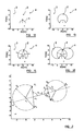
- the shape is expanded around the vehicle's position until the edge of this shape encounters a cluster of measurements.
- a cluster of measurements will, in general, correspond to a detected object near the vehicle.
- the radius of the circle is expanded until any part of the circumference of the circle encounters a measurement.
- a sector 1 of a circle is expanded around a chord, being a line passing through the vehicle's position, from an initial radius to a final radius, at which point (see Figure 1b ) a measurement 2 is encountered.
- Each expansion step calculates the maximum size for the circle sector in a specific expanding direction. If no measurement is encountered, the expansion is stopped when the circle sector reaches a maximum size, which will depend on the size of the vehicle and the range of the object detection arrangement, and for a conventional motor car this maximum size may be around 30 m.
- the process of expanding and splitting circle sectors continues until all of the available empty space on the map detected by the object detection system has been accounted for.
- the expansion algorithm does not allow a chord or radius less then a predetermined size, and once again this will depend upon the size of the vehicle, and for a conventional vehicle may be around 1 - 2 m.
- these exceptions may include: measurements which appear to be moving, which are likely to represent cyclists, pedestrians or other vehicles; cases where the number of measurements in a cluster is too few; detected objects which have not been detected on previous occasions, which are likely to be non-fixed objects such as parked cars or obstacles in the road; and objects having certain shapes, which can be classified as moveable objects. Probabilistic criteria, such as median filtering, may also be used to disregard certain objects.
- a number of primitives are determined, each corresponding to a circle sector at maximum expansion (i.e. at the point at which a measurement was encountered at the circumference of the circle sector). Relationships between primitives (preferably consecutive primitives) are computed as signatures, which represent the regions of empty space in the map. These signatures are stored in the memory, as discussed above, along with an associated location provided by the positioning system. In alternative embodiments, each signature may simply comprise one or more primitives.
- the signatures can be retrieved and compared to currently-detected data.
- the stored signatures can also be used as a position reference to other detected features, such as various types of intersection, traffic signs, lanes, traffic flow or other information.
- the stored signatures can be related to other stored information and newly-detected information relating to the intersection. This can allow accurate placement of the vehicle, and also assist in determining whether objects are behaving unusually, such as vehicles moving in an unexpected direction in a particular lane.
- An advantage of this approach is that the signatures representing the empty space around the vehicle can be stored efficiently using relatively small amounts of data. For instance, the signatures discussed above comprising relationships between primitives of circle sectors and chords can be stored using only seven parameters, as can be seen with reference to Figure 2 .
- the definition of a signature is based on the angles between the chord vectors and the vector connecting the two circle sectors.
- the chord lengths and the radius of the circle sectors are also contained in the definition.
- the frame attached to the signature has its origin at z 1 + z 3 2 .
- a newly-detected signature may be matched against previously-stored reference signatures by the Mahalanobis distance.
- v sig ( n ) ( Z s - X s ( n )) T S s ( n ) -1 ( Z s - X s ( n )), is ⁇ 2 distributed as it is assumed that the noise involved is normally distributed.
- the distance variable v sig ( n ) is also dimensionless and compensates for interactions between the variables.
- the match v sig ( n ) with the highest probability is taken, and checks are made against tables to determine if the match is significant.
- the test has seven degrees of freedom and is equal to the number of parameters of each signature.
- the confidence level of the ⁇ 2 distribution with a given number of degrees of freedom may be determined from statistical tables.
- Signatures gathered may be compiled into voronoi graphs, as a skilled person will understand. It will therefore be possible to apply statistical methods to get an estimate of the accuracy of the calculated Voronoi tree. It is also possible to apply prediction, tracking and estimation through techniques such as Kalman filters, particularly extended Kalman filer techniques. These statistical methods can be applied to detect changes, isolate spurious results and detect erroneous sensor readings.
- each measurement corresponding to a detected object must be stored individually, which invariably leads to the storage of a very large number of locations, occupying a large amount of memory space.
- the objects are often classified according to their shape, which increases the storage space required.
- storing signatures representing regions of empty space can be, as seen above, very efficient.
- a signature representing a large region of space can be stored using only seven parameters. The nature and shape of objects and edges themselves need not be stored, and instead the shape of the empty space is stored.
- the method carries the additional advantage that the empty space actually defines the area of clear passage available to the vehicle, and this can be useful when navigating autonomous or semi-autonomous vehicles.
- the method using signatures as described above can be of particular application to the control and navigation of such vehicles, as the line of length d connecting the centres of the chords c 1 , c 2 represents a clear path along which the vehicle may travel.
- the vehicle may proceed along these lines, from the centre of one chord to the next, and it will be appreciated that the course thus followed will be approximately in the middle of the free space available, thus minimising the chance of the vehicle colliding with any other objects.
- circle sectors in between two circle sectors that form a signature may be stored, either as part of the signature or as supplementary information to assist in navigation through free space.
- Figure 3 shows a course 7 for an autonomous vehicle plotted among obstacles 8 in this way.
- This method may also find applications for driver-controlled vehicles. For instance, a vehicle could be placed into an automatic parking mode, in which this method is used to control the vehicle temporarily to perform an awkward reverse parking manoeuvre, or to park the vehicle in conditions where visibility is poor, due to low light levels or obscuration by other objects.
- an alarm may be raised, or an operator may be informed.
- the height below which objects are disregarded may be around 0.2 m.
- embodiments of the present invention may provide effective and computationally efficient methods of locating a vehicle with respect to its surroundings, which will find utility in many fields.
Landscapes
- Engineering & Computer Science (AREA)
- Remote Sensing (AREA)
- Radar, Positioning & Navigation (AREA)
- Physics & Mathematics (AREA)
- General Physics & Mathematics (AREA)
- Electromagnetism (AREA)
- Computer Networks & Wireless Communication (AREA)
- Traffic Control Systems (AREA)
- Position Fixing By Use Of Radio Waves (AREA)
- Radar Systems Or Details Thereof (AREA)
Claims (12)
- Verfahren zum Analysieren einer Fahrzeugumgebung, das folgende Schritte umfasst:Erfassen von Daten zu Objekten (2, 3, 4) in der Nähe des Fahrzeugs;Analysieren der Daten zum Bestimmen von Freiraumbereichen um das Fahrzeug herum;Erzeugen von einer oder mehreren Signaturen, die zumindest einige der Freiraumbereiche darstellt bzw. darstellen; undSpeichern der Signaturen für einen späteren Abruf,dadurch gekennzeichnet, dass der Schritt des Erzeugens von einer oder mehreren Signaturen den Schritt des Erzeugens von einem oder mehreren Primitiven umfasst, das bzw. die zumindest einige der Freiraumbereiche beschreibt bzw. beschreiben, indem eine Form um eine Position herum ausgedehnt wird, bis ein Umfang der Form ein erfasstes Objekt (2, 3, 4) erreicht, wobei, wenn ein Umfang der Form ein erfasstes Objekt (2, 3, 4) erreicht, eine oder mehrere weitere Formen definiert wird bzw. werden und die weiteren Formen in Richtungen ausgedehnt werden, in denen das erfasste Objekt (2, 3, 4) gemieden wird, wobei eine Ausgangsform (1) so definiert ist, dass sie sich von einer Position aus ausdehnt, die im Wesentlichen mit dem Standort des Fahrzeugs in Zusammenhang steht, und die vorangehenden Schritte wiederholt werden, bis im Wesentlichen der gesamte verfügbare Freiraum um das Fahrzeug herum berücksichtigt worden ist.
- Verfahren nach einem vorhergehenden Anspruch, wobei die Form (1) ein Kreisausschnitt ist und wobei die Ausdehnung des Ausschnitts um eine Sehne davon herum erfolgt.
- Verfahren nach einem vorhergehenden Anspruch, wobei ein erfasstes Objekt (2, 3, 4) außer Acht gelassen werden kann, wenn festgestellt wird, dass sich das Objekt (2, 3, 4) bewegt.
- Verfahren nach einem vorhergehenden Anspruch, wobei ein erfasstes Objekt (2, 3, 4) außer Acht gelassen werden kann, wenn die Form des Objekts (2, 3, 4) im Wesentlichen mit einer vorher festgelegten Form übereinstimmt.
- Verfahren nach einem vorhergehenden Anspruch, wobei ein erfasstes Objekt (2, 3, 4) außer Acht gelassen werden kann, wenn die Anzahl erfasster Messwerte, die das Objekt (2, 3, 4) umfassen, unter einer vorher festgelegten Schwelle liegt.
- Verfahren nach einem vorhergehenden Anspruch, wobei, wenn derselbe Raumbereich mehrere Male analysiert wird, ein erfasstes Objekt (2, 3, 4) außer Acht gelassen werden kann, wenn das Objekt (2, 3, 4) nicht bei jedem Mal erfasst wird.
- Verfahren nach einem vorhergehenden Anspruch, wobei eine Signatur ein oder mehrere Primitive umfasst.
- Verfahren nach einem vorhergehenden Anspruch, wobei eine Signatur einen Ausdruck für ein Verhältnis zwischen zwei Primitiven umfasst.
- Verfahren nach Anspruch 8, wobei eine Signatur einen Ausdruck für ein Verhältnis zwischen zwei nachfolgend bestimmten Primitiven umfasst.
- Verfahren nach einem vorhergehenden Anspruch, wobei der Schritt des Speicherns der Signaturen den Schritt des Speicherns der Signaturen in Verbindung mit einer Position umfasst, die aus einem Positionsbestimmungssystem bestimmt wird.
- Verfahren nach Anspruch 10, das ferner den Schritt des Vergleichens von neu erfassten Signaturen mit gespeicherten Signaturen umfasst, die Positionen zugehörig sind, die mit den neu erfassten Signaturen identisch sind oder ihnen ähneln, damit der Standort des Fahrzeugs bezogen auf die gespeicherten Signaturen bestimmt wird.
- Verfahren nach einem vorhergehenden Anspruch, das ferner den Schritt des Erzeugens eines Ausgangssignals umfasst, wenn ein Objekt (2, 3, 4) an einem Ort erfasst wird, von dem vorher festgestellt wurde, dass er Freiraum umfasst.
Applications Claiming Priority (2)
| Application Number | Priority Date | Filing Date | Title |
|---|---|---|---|
| GB0620183A GB2442776A (en) | 2006-10-11 | 2006-10-11 | Object detection arrangement and positioning system for analysing the surroundings of a vehicle |
| PCT/SE2007/000860 WO2008044979A1 (en) | 2006-10-11 | 2007-09-28 | A method of analysing the surroundings of a vehicle |
Publications (3)
| Publication Number | Publication Date |
|---|---|
| EP2074380A1 EP2074380A1 (de) | 2009-07-01 |
| EP2074380A4 EP2074380A4 (de) | 2009-10-14 |
| EP2074380B1 true EP2074380B1 (de) | 2015-09-02 |
Family
ID=37491332
Family Applications (1)
| Application Number | Title | Priority Date | Filing Date |
|---|---|---|---|
| EP07835064.2A Not-in-force EP2074380B1 (de) | 2006-10-11 | 2007-09-28 | Verfahren zur analyse einer fahrzeugumgebung |
Country Status (5)
| Country | Link |
|---|---|
| US (1) | US8558679B2 (de) |
| EP (1) | EP2074380B1 (de) |
| JP (1) | JP5301448B2 (de) |
| GB (1) | GB2442776A (de) |
| WO (1) | WO2008044979A1 (de) |
Cited By (1)
| Publication number | Priority date | Publication date | Assignee | Title |
|---|---|---|---|---|
| CN108680176A (zh) * | 2018-05-16 | 2018-10-19 | 电子科技大学 | 一种盲人导航避障地图的生成方法 |
Families Citing this family (26)
| Publication number | Priority date | Publication date | Assignee | Title |
|---|---|---|---|---|
| DE102008008499B4 (de) * | 2008-02-11 | 2009-12-31 | Siemens Aktiengesellschaft | Verfahren zur rechnergestützten Berechnung der Bewegung eines Objekts aus Sensordaten |
| DE102009028760A1 (de) * | 2009-08-20 | 2011-02-24 | Robert Bosch Gmbh | Verfahren zur Prüfung der Umgebung eines Kraftfahrzeugs |
| JP5666322B2 (ja) * | 2010-01-20 | 2015-02-12 | 株式会社Ihiエアロスペース | 経路生成装置と方法および経路生成装置を備える移動装置 |
| JP5585177B2 (ja) * | 2010-04-12 | 2014-09-10 | トヨタ自動車株式会社 | 先行車位置判定装置 |
| JP5503419B2 (ja) * | 2010-06-03 | 2014-05-28 | 株式会社日立製作所 | 無人搬送車および走行制御方法 |
| JP5709476B2 (ja) * | 2010-11-10 | 2015-04-30 | 富士通テン株式会社 | レーダ装置 |
| JP2012145998A (ja) * | 2011-01-07 | 2012-08-02 | Ihi Aerospace Co Ltd | 自律走行体 |
| JP5666327B2 (ja) * | 2011-01-31 | 2015-02-12 | 株式会社Ihiエアロスペース | 無人移動体及び無人移動体の制御方法 |
| US20130103305A1 (en) * | 2011-10-19 | 2013-04-25 | Robert Bosch Gmbh | System for the navigation of oversized vehicles |
| US9221461B2 (en) * | 2012-09-05 | 2015-12-29 | Google Inc. | Construction zone detection using a plurality of information sources |
| US8996228B1 (en) | 2012-09-05 | 2015-03-31 | Google Inc. | Construction zone object detection using light detection and ranging |
| US9195914B2 (en) | 2012-09-05 | 2015-11-24 | Google Inc. | Construction zone sign detection |
| US9056395B1 (en) | 2012-09-05 | 2015-06-16 | Google Inc. | Construction zone sign detection using light detection and ranging |
| US8996295B2 (en) * | 2012-09-11 | 2015-03-31 | GM Global Technology Operations LLC | Vehicle range projection |
| US9423498B1 (en) * | 2012-09-25 | 2016-08-23 | Google Inc. | Use of motion data in the processing of automotive radar image processing |
| EP3304520B1 (de) | 2015-05-27 | 2023-09-20 | Dov Moran | Alarmierung von prognostizierten unfällen zwischen fahrerlosen autos |
| US10031522B2 (en) | 2015-05-27 | 2018-07-24 | Dov Moran | Alerting predicted accidents between driverless cars |
| EP3182155A1 (de) * | 2015-12-17 | 2017-06-21 | Autoliv Development AB | Zur bestimmung einer freien domäne angeordnetes kraftfahrzeugradarsystem |
| US10078790B2 (en) | 2017-02-16 | 2018-09-18 | Honda Motor Co., Ltd. | Systems for generating parking maps and methods thereof |
| JP2019090392A (ja) * | 2017-11-16 | 2019-06-13 | 日立オートモティブシステムズ株式会社 | 車両制御装置 |
| US10908614B2 (en) | 2017-12-19 | 2021-02-02 | Here Global B.V. | Method and apparatus for providing unknown moving object detection |
| US11164016B2 (en) | 2018-05-17 | 2021-11-02 | Uatc, Llc | Object detection and property determination for autonomous vehicles |
| WO2020157844A1 (ja) * | 2019-01-30 | 2020-08-06 | 三菱電機株式会社 | 計測装置、計測方法及び計測プログラム |
| CN111284337B (zh) * | 2020-02-17 | 2021-05-18 | 赵婷婷 | 运载工具无线充电对准的方法及其系统 |
| US11288520B2 (en) * | 2020-06-25 | 2022-03-29 | Toyota Motor Engineering & Manufacturing N.A. Inc. | Systems and methods to aggregate and distribute dynamic information of crowdsourcing vehicles for edge-assisted live map service |
| DE102022203674A1 (de) | 2022-04-12 | 2023-10-12 | Volkswagen Aktiengesellschaft | Verfahren und Detektionseinrichtung zum Detektieren von Ereignissen und Kraftfahrzeug |
Family Cites Families (20)
| Publication number | Priority date | Publication date | Assignee | Title |
|---|---|---|---|---|
| GB1447985A (en) * | 1973-01-16 | 1976-09-02 | Gen Electric Co Ltd | Collision avoidance systems |
| US4962453A (en) * | 1989-02-07 | 1990-10-09 | Transitions Research Corporation | Autonomous vehicle for working on a surface and method of controlling same |
| JPH0835818A (ja) * | 1994-07-25 | 1996-02-06 | Omron Corp | 画像処理装置および方法 |
| US6218961B1 (en) * | 1996-10-23 | 2001-04-17 | G.E. Harris Railway Electronics, L.L.C. | Method and system for proximity detection and location determination |
| US6553308B1 (en) * | 1999-04-29 | 2003-04-22 | Donnelly Corporation | Vehicle-based navigation system with smart map filtering, portable unit home-base registration and multiple navigation system preferential use |
| JP2000171250A (ja) * | 1998-12-02 | 2000-06-23 | Japan Aviation Electronics Industry Ltd | 移動体現在位置検出方法 |
| DE10114932B4 (de) * | 2001-03-26 | 2005-09-15 | Daimlerchrysler Ag | Dreidimensionale Umfelderfassung |
| US6828920B2 (en) * | 2001-06-04 | 2004-12-07 | Lockheed Martin Orincon Corporation | System and method for classifying vehicles |
| EP1554639B1 (de) * | 2002-10-23 | 2007-12-12 | Siemens Aktiengesellschaft | Verfahren und anordnung sowie computerprogramm mit programmcode-mitteln und computerprogramm-produkt zur bildung einer graphenstruktur zur beschreibung einer fläche mit einer freifläche und einer belegtfläche |
| JP4005483B2 (ja) * | 2002-11-20 | 2007-11-07 | 日産自動車株式会社 | 車線逸脱防止装置 |
| DE10257722A1 (de) * | 2002-12-11 | 2004-07-01 | Robert Bosch Gmbh | Einparkhilfe |
| FI115678B (fi) * | 2003-03-25 | 2005-06-15 | Sandvik Tamrock Oy | Järjestely kaivosajoneuvon törmäyksenestoon |
| DE10323915A1 (de) * | 2003-05-23 | 2005-02-03 | Daimlerchrysler Ag | Kamerabasierte Positionserkennung für ein Straßenfahrzeug |
| US6967593B2 (en) * | 2003-06-26 | 2005-11-22 | International Business Machines Corporation | Emergency vehicle approach warning method and system |
| JP3994950B2 (ja) * | 2003-09-19 | 2007-10-24 | ソニー株式会社 | 環境認識装置及び方法、経路計画装置及び方法、並びにロボット装置 |
| JP2005149021A (ja) * | 2003-11-13 | 2005-06-09 | Denso Corp | 衝突可能性判定装置 |
| US7451046B2 (en) * | 2004-04-29 | 2008-11-11 | Sanjeev Nath | Imminent collision warning system and method |
| US20060041375A1 (en) * | 2004-08-19 | 2006-02-23 | Geographic Data Technology, Inc. | Automated georeferencing of digitized map images |
| DE102004047130B4 (de) * | 2004-09-27 | 2012-07-26 | Andreas Stopp | Umgebungsmodellierung für autonome mobile Systeme |
| WO2006084385A1 (en) * | 2005-02-11 | 2006-08-17 | Macdonald Dettwiler & Associates Inc. | 3d imaging system |
-
2006
- 2006-10-11 GB GB0620183A patent/GB2442776A/en not_active Withdrawn
-
2007
- 2007-09-28 US US12/445,093 patent/US8558679B2/en not_active Expired - Fee Related
- 2007-09-28 JP JP2009532324A patent/JP5301448B2/ja not_active Expired - Fee Related
- 2007-09-28 EP EP07835064.2A patent/EP2074380B1/de not_active Not-in-force
- 2007-09-28 WO PCT/SE2007/000860 patent/WO2008044979A1/en not_active Ceased
Cited By (1)
| Publication number | Priority date | Publication date | Assignee | Title |
|---|---|---|---|---|
| CN108680176A (zh) * | 2018-05-16 | 2018-10-19 | 电子科技大学 | 一种盲人导航避障地图的生成方法 |
Also Published As
| Publication number | Publication date |
|---|---|
| US20100164701A1 (en) | 2010-07-01 |
| EP2074380A1 (de) | 2009-07-01 |
| EP2074380A4 (de) | 2009-10-14 |
| JP2010507514A (ja) | 2010-03-11 |
| JP5301448B2 (ja) | 2013-09-25 |
| US8558679B2 (en) | 2013-10-15 |
| WO2008044979A1 (en) | 2008-04-17 |
| GB2442776A (en) | 2008-04-16 |
| GB0620183D0 (en) | 2006-11-22 |
Similar Documents
| Publication | Publication Date | Title |
|---|---|---|
| EP2074380B1 (de) | Verfahren zur analyse einer fahrzeugumgebung | |
| US11898855B2 (en) | Assistance control system that prioritizes route candidates based on unsuitable sections thereof | |
| US9298992B2 (en) | Geographic feature-based localization with feature weighting | |
| US10013508B2 (en) | Joint probabilistic modeling and inference of intersection structure | |
| US9140792B2 (en) | System and method for sensor based environmental model construction | |
| US11555705B2 (en) | Localization using dynamic landmarks | |
| KR102125538B1 (ko) | 자율 주행을 위한 효율적인 맵 매칭 방법 및 그 장치 | |
| US9395192B1 (en) | Methods and systems for road and lane boundary tracing | |
| US12492914B2 (en) | Submap geographic projections | |
| EP3997538A1 (de) | Polylinienkonturdarstellungen für autonome fahrzeuge | |
| EP3705385B1 (de) | Verfahren und einheit zum autonomen einparken eines fahrzeugs | |
| JP7344182B2 (ja) | 情報処理装置 | |
| US11087147B2 (en) | Vehicle lane mapping | |
| Rabe et al. | Ego-lane estimation for lane-level navigation in urban scenarios | |
| Prophet et al. | Parking space detection from a radar based target list | |
| Moras et al. | Drivable space characterization using automotive lidar and georeferenced map information | |
| Valldorf et al. | Advanced Microsystems for Automotive Applications 2007 | |
| US11037324B2 (en) | Systems and methods for object detection including z-domain and range-domain analysis | |
| CN116890847A (zh) | 车辆姿势评估 | |
| Dean et al. | Terrain-based road vehicle localization on multi-lane highways | |
| WO2021229704A1 (ja) | 物体認識装置、経路生成装置、駐車支援装置、物体認識システム、経路生成システム及び駐車支援システム | |
| EP4390318A1 (de) | Verfahren und system zur bestimmung einer genauen position eines fahrzeugs auf basis von sensordaten | |
| US20250391181A1 (en) | Systems and methods for predicting boundary lines on a road by comparing data and resolving conflicts | |
| US20250369770A1 (en) | Systems and methods for estimating boundary lines on a road by comparing vehicle relationships | |
| Wei et al. | Obstacle detection based on a 2D large range sonar model |
Legal Events
| Date | Code | Title | Description |
|---|---|---|---|
| PUAI | Public reference made under article 153(3) epc to a published international application that has entered the european phase |
Free format text: ORIGINAL CODE: 0009012 |
|
| 17P | Request for examination filed |
Effective date: 20090323 |
|
| AK | Designated contracting states |
Kind code of ref document: A1 Designated state(s): AT BE BG CH CY CZ DE DK EE ES FI FR GB GR HU IE IS IT LI LT LU LV MC MT NL PL PT RO SE SI SK TR |
|
| AX | Request for extension of the european patent |
Extension state: AL BA HR MK RS |
|
| DA4 | Supplementary search report drawn up and despatched (deleted) | ||
| 17Q | First examination report despatched |
Effective date: 20110207 |
|
| DAX | Request for extension of the european patent (deleted) | ||
| REG | Reference to a national code |
Ref country code: DE Ref legal event code: R079 Ref document number: 602007042930 Country of ref document: DE Free format text: PREVIOUS MAIN CLASS: G01C0021260000 Ipc: G01S0005020000 |
|
| GRAP | Despatch of communication of intention to grant a patent |
Free format text: ORIGINAL CODE: EPIDOSNIGR1 |
|
| RIC1 | Information provided on ipc code assigned before grant |
Ipc: G01C 21/26 20060101ALI20150217BHEP Ipc: G01S 5/02 20100101AFI20150217BHEP Ipc: G05D 1/02 20060101ALI20150217BHEP Ipc: G08G 1/16 20060101ALI20150217BHEP Ipc: G01S 13/86 20060101ALI20150217BHEP |
|
| INTG | Intention to grant announced |
Effective date: 20150325 |
|
| GRAS | Grant fee paid |
Free format text: ORIGINAL CODE: EPIDOSNIGR3 |
|
| GRAA | (expected) grant |
Free format text: ORIGINAL CODE: 0009210 |
|
| AK | Designated contracting states |
Kind code of ref document: B1 Designated state(s): AT BE BG CH CY CZ DE DK EE ES FI FR GB GR HU IE IS IT LI LT LU LV MC MT NL PL PT RO SE SI SK TR |
|
| REG | Reference to a national code |
Ref country code: GB Ref legal event code: FG4D |
|
| REG | Reference to a national code |
Ref country code: AT Ref legal event code: REF Ref document number: 746967 Country of ref document: AT Kind code of ref document: T Effective date: 20150915 Ref country code: CH Ref legal event code: EP |
|
| REG | Reference to a national code |
Ref country code: IE Ref legal event code: FG4D |
|
| REG | Reference to a national code |
Ref country code: DE Ref legal event code: R096 Ref document number: 602007042930 Country of ref document: DE |
|
| REG | Reference to a national code |
Ref country code: FR Ref legal event code: PLFP Year of fee payment: 9 |
|
| REG | Reference to a national code |
Ref country code: SE Ref legal event code: TRGR |
|
| REG | Reference to a national code |
Ref country code: AT Ref legal event code: MK05 Ref document number: 746967 Country of ref document: AT Kind code of ref document: T Effective date: 20150902 |
|
| PG25 | Lapsed in a contracting state [announced via postgrant information from national office to epo] |
Ref country code: LV Free format text: LAPSE BECAUSE OF FAILURE TO SUBMIT A TRANSLATION OF THE DESCRIPTION OR TO PAY THE FEE WITHIN THE PRESCRIBED TIME-LIMIT Effective date: 20150902 Ref country code: FI Free format text: LAPSE BECAUSE OF FAILURE TO SUBMIT A TRANSLATION OF THE DESCRIPTION OR TO PAY THE FEE WITHIN THE PRESCRIBED TIME-LIMIT Effective date: 20150902 Ref country code: LT Free format text: LAPSE BECAUSE OF FAILURE TO SUBMIT A TRANSLATION OF THE DESCRIPTION OR TO PAY THE FEE WITHIN THE PRESCRIBED TIME-LIMIT Effective date: 20150902 Ref country code: GR Free format text: LAPSE BECAUSE OF FAILURE TO SUBMIT A TRANSLATION OF THE DESCRIPTION OR TO PAY THE FEE WITHIN THE PRESCRIBED TIME-LIMIT Effective date: 20151203 |
|
| REG | Reference to a national code |
Ref country code: LT Ref legal event code: MG4D Ref country code: NL Ref legal event code: MP Effective date: 20150902 |
|
| PG25 | Lapsed in a contracting state [announced via postgrant information from national office to epo] |
Ref country code: PL Free format text: LAPSE BECAUSE OF FAILURE TO SUBMIT A TRANSLATION OF THE DESCRIPTION OR TO PAY THE FEE WITHIN THE PRESCRIBED TIME-LIMIT Effective date: 20150902 Ref country code: ES Free format text: LAPSE BECAUSE OF FAILURE TO SUBMIT A TRANSLATION OF THE DESCRIPTION OR TO PAY THE FEE WITHIN THE PRESCRIBED TIME-LIMIT Effective date: 20150902 Ref country code: AT Free format text: LAPSE BECAUSE OF FAILURE TO SUBMIT A TRANSLATION OF THE DESCRIPTION OR TO PAY THE FEE WITHIN THE PRESCRIBED TIME-LIMIT Effective date: 20150902 |
|
| PG25 | Lapsed in a contracting state [announced via postgrant information from national office to epo] |
Ref country code: IS Free format text: LAPSE BECAUSE OF FAILURE TO SUBMIT A TRANSLATION OF THE DESCRIPTION OR TO PAY THE FEE WITHIN THE PRESCRIBED TIME-LIMIT Effective date: 20160102 Ref country code: IT Free format text: LAPSE BECAUSE OF FAILURE TO SUBMIT A TRANSLATION OF THE DESCRIPTION OR TO PAY THE FEE WITHIN THE PRESCRIBED TIME-LIMIT Effective date: 20150902 Ref country code: SK Free format text: LAPSE BECAUSE OF FAILURE TO SUBMIT A TRANSLATION OF THE DESCRIPTION OR TO PAY THE FEE WITHIN THE PRESCRIBED TIME-LIMIT Effective date: 20150902 Ref country code: CZ Free format text: LAPSE BECAUSE OF FAILURE TO SUBMIT A TRANSLATION OF THE DESCRIPTION OR TO PAY THE FEE WITHIN THE PRESCRIBED TIME-LIMIT Effective date: 20150902 Ref country code: EE Free format text: LAPSE BECAUSE OF FAILURE TO SUBMIT A TRANSLATION OF THE DESCRIPTION OR TO PAY THE FEE WITHIN THE PRESCRIBED TIME-LIMIT Effective date: 20150902 Ref country code: NL Free format text: LAPSE BECAUSE OF FAILURE TO SUBMIT A TRANSLATION OF THE DESCRIPTION OR TO PAY THE FEE WITHIN THE PRESCRIBED TIME-LIMIT Effective date: 20150902 |
|
| REG | Reference to a national code |
Ref country code: CH Ref legal event code: PL |
|
| PG25 | Lapsed in a contracting state [announced via postgrant information from national office to epo] |
Ref country code: RO Free format text: LAPSE BECAUSE OF FAILURE TO SUBMIT A TRANSLATION OF THE DESCRIPTION OR TO PAY THE FEE WITHIN THE PRESCRIBED TIME-LIMIT Effective date: 20150902 Ref country code: PT Free format text: LAPSE BECAUSE OF FAILURE TO SUBMIT A TRANSLATION OF THE DESCRIPTION OR TO PAY THE FEE WITHIN THE PRESCRIBED TIME-LIMIT Effective date: 20160104 |
|
| REG | Reference to a national code |
Ref country code: DE Ref legal event code: R097 Ref document number: 602007042930 Country of ref document: DE |
|
| REG | Reference to a national code |
Ref country code: IE Ref legal event code: MM4A |
|
| PG25 | Lapsed in a contracting state [announced via postgrant information from national office to epo] |
Ref country code: MC Free format text: LAPSE BECAUSE OF FAILURE TO SUBMIT A TRANSLATION OF THE DESCRIPTION OR TO PAY THE FEE WITHIN THE PRESCRIBED TIME-LIMIT Effective date: 20150902 |
|
| PLBE | No opposition filed within time limit |
Free format text: ORIGINAL CODE: 0009261 |
|
| STAA | Information on the status of an ep patent application or granted ep patent |
Free format text: STATUS: NO OPPOSITION FILED WITHIN TIME LIMIT |
|
| PG25 | Lapsed in a contracting state [announced via postgrant information from national office to epo] |
Ref country code: IE Free format text: LAPSE BECAUSE OF NON-PAYMENT OF DUE FEES Effective date: 20150928 Ref country code: LI Free format text: LAPSE BECAUSE OF NON-PAYMENT OF DUE FEES Effective date: 20150930 Ref country code: CH Free format text: LAPSE BECAUSE OF NON-PAYMENT OF DUE FEES Effective date: 20150930 |
|
| 26N | No opposition filed |
Effective date: 20160603 |
|
| PG25 | Lapsed in a contracting state [announced via postgrant information from national office to epo] |
Ref country code: DK Free format text: LAPSE BECAUSE OF FAILURE TO SUBMIT A TRANSLATION OF THE DESCRIPTION OR TO PAY THE FEE WITHIN THE PRESCRIBED TIME-LIMIT Effective date: 20150902 Ref country code: SI Free format text: LAPSE BECAUSE OF FAILURE TO SUBMIT A TRANSLATION OF THE DESCRIPTION OR TO PAY THE FEE WITHIN THE PRESCRIBED TIME-LIMIT Effective date: 20150902 |
|
| REG | Reference to a national code |
Ref country code: FR Ref legal event code: PLFP Year of fee payment: 10 |
|
| PG25 | Lapsed in a contracting state [announced via postgrant information from national office to epo] |
Ref country code: BE Free format text: LAPSE BECAUSE OF FAILURE TO SUBMIT A TRANSLATION OF THE DESCRIPTION OR TO PAY THE FEE WITHIN THE PRESCRIBED TIME-LIMIT Effective date: 20150902 |
|
| PG25 | Lapsed in a contracting state [announced via postgrant information from national office to epo] |
Ref country code: MT Free format text: LAPSE BECAUSE OF FAILURE TO SUBMIT A TRANSLATION OF THE DESCRIPTION OR TO PAY THE FEE WITHIN THE PRESCRIBED TIME-LIMIT Effective date: 20150902 |
|
| PG25 | Lapsed in a contracting state [announced via postgrant information from national office to epo] |
Ref country code: BG Free format text: LAPSE BECAUSE OF FAILURE TO SUBMIT A TRANSLATION OF THE DESCRIPTION OR TO PAY THE FEE WITHIN THE PRESCRIBED TIME-LIMIT Effective date: 20150902 Ref country code: HU Free format text: LAPSE BECAUSE OF FAILURE TO SUBMIT A TRANSLATION OF THE DESCRIPTION OR TO PAY THE FEE WITHIN THE PRESCRIBED TIME-LIMIT; INVALID AB INITIO Effective date: 20070928 |
|
| PG25 | Lapsed in a contracting state [announced via postgrant information from national office to epo] |
Ref country code: CY Free format text: LAPSE BECAUSE OF FAILURE TO SUBMIT A TRANSLATION OF THE DESCRIPTION OR TO PAY THE FEE WITHIN THE PRESCRIBED TIME-LIMIT Effective date: 20150902 |
|
| PG25 | Lapsed in a contracting state [announced via postgrant information from national office to epo] |
Ref country code: TR Free format text: LAPSE BECAUSE OF FAILURE TO SUBMIT A TRANSLATION OF THE DESCRIPTION OR TO PAY THE FEE WITHIN THE PRESCRIBED TIME-LIMIT Effective date: 20150902 |
|
| REG | Reference to a national code |
Ref country code: FR Ref legal event code: PLFP Year of fee payment: 11 |
|
| PG25 | Lapsed in a contracting state [announced via postgrant information from national office to epo] |
Ref country code: LU Free format text: LAPSE BECAUSE OF NON-PAYMENT OF DUE FEES Effective date: 20150928 |
|
| REG | Reference to a national code |
Ref country code: FR Ref legal event code: PLFP Year of fee payment: 12 |
|
| REG | Reference to a national code |
Ref country code: DE Ref legal event code: R081 Ref document number: 602007042930 Country of ref document: DE Owner name: ARRIVER SOFTWARE AB, SE Free format text: FORMER OWNER: AUTOLIV DEVELOPMENT AB, VARGARDA, SE Ref country code: DE Ref legal event code: R081 Ref document number: 602007042930 Country of ref document: DE Owner name: VEONEER SWEDEN AB, SE Free format text: FORMER OWNER: AUTOLIV DEVELOPMENT AB, VARGARDA, SE |
|
| REG | Reference to a national code |
Ref country code: GB Ref legal event code: 732E Free format text: REGISTERED BETWEEN 20190523 AND 20190529 |
|
| REG | Reference to a national code |
Ref country code: GB Ref legal event code: 732E Free format text: REGISTERED BETWEEN 20220818 AND 20220824 |
|
| REG | Reference to a national code |
Ref country code: DE Ref legal event code: R081 Ref document number: 602007042930 Country of ref document: DE Owner name: ARRIVER SOFTWARE AB, SE Free format text: FORMER OWNER: VEONEER SWEDEN AB, VARGARDA, SE |
|
| PGFP | Annual fee paid to national office [announced via postgrant information from national office to epo] |
Ref country code: GB Payment date: 20230810 Year of fee payment: 17 |
|
| PGFP | Annual fee paid to national office [announced via postgrant information from national office to epo] |
Ref country code: SE Payment date: 20230908 Year of fee payment: 17 Ref country code: FR Payment date: 20230808 Year of fee payment: 17 Ref country code: DE Payment date: 20230808 Year of fee payment: 17 |
|
| REG | Reference to a national code |
Ref country code: DE Ref legal event code: R119 Ref document number: 602007042930 Country of ref document: DE |
|
| REG | Reference to a national code |
Ref country code: SE Ref legal event code: EUG |
|
| GBPC | Gb: european patent ceased through non-payment of renewal fee |
Effective date: 20240928 |
|
| PG25 | Lapsed in a contracting state [announced via postgrant information from national office to epo] |
Ref country code: DE Free format text: LAPSE BECAUSE OF NON-PAYMENT OF DUE FEES Effective date: 20250401 |
|
| PG25 | Lapsed in a contracting state [announced via postgrant information from national office to epo] |
Ref country code: GB Free format text: LAPSE BECAUSE OF NON-PAYMENT OF DUE FEES Effective date: 20240928 |
|
| PG25 | Lapsed in a contracting state [announced via postgrant information from national office to epo] |
Ref country code: FR Free format text: LAPSE BECAUSE OF NON-PAYMENT OF DUE FEES Effective date: 20240930 |
|
| PG25 | Lapsed in a contracting state [announced via postgrant information from national office to epo] |
Ref country code: SE Free format text: LAPSE BECAUSE OF NON-PAYMENT OF DUE FEES Effective date: 20240929 |