EP2128656A2 - Meeresklima-Informationssystem und Verfahren zur Erfassung und Verarbeitung von Meeresklimadaten - Google Patents
Meeresklima-Informationssystem und Verfahren zur Erfassung und Verarbeitung von Meeresklimadaten Download PDFInfo
- Publication number
- EP2128656A2 EP2128656A2 EP09161158A EP09161158A EP2128656A2 EP 2128656 A2 EP2128656 A2 EP 2128656A2 EP 09161158 A EP09161158 A EP 09161158A EP 09161158 A EP09161158 A EP 09161158A EP 2128656 A2 EP2128656 A2 EP 2128656A2
- Authority
- EP
- European Patent Office
- Prior art keywords
- maritime
- climate information
- wireless network
- coordinate
- climate
- Prior art date
- Legal status (The legal status is an assumption and is not a legal conclusion. Google has not performed a legal analysis and makes no representation as to the accuracy of the status listed.)
- Withdrawn
Links
Images




Classifications
-
- G—PHYSICS
- G01—MEASURING; TESTING
- G01W—METEOROLOGY
- G01W1/00—Meteorology
-
- G—PHYSICS
- G06—COMPUTING OR CALCULATING; COUNTING
- G06F—ELECTRIC DIGITAL DATA PROCESSING
- G06F16/00—Information retrieval; Database structures therefor; File system structures therefor
- G06F16/20—Information retrieval; Database structures therefor; File system structures therefor of structured data, e.g. relational data
- G06F16/29—Geographical information databases
-
- Y—GENERAL TAGGING OF NEW TECHNOLOGICAL DEVELOPMENTS; GENERAL TAGGING OF CROSS-SECTIONAL TECHNOLOGIES SPANNING OVER SEVERAL SECTIONS OF THE IPC; TECHNICAL SUBJECTS COVERED BY FORMER USPC CROSS-REFERENCE ART COLLECTIONS [XRACs] AND DIGESTS
- Y02—TECHNOLOGIES OR APPLICATIONS FOR MITIGATION OR ADAPTATION AGAINST CLIMATE CHANGE
- Y02A—TECHNOLOGIES FOR ADAPTATION TO CLIMATE CHANGE
- Y02A90/00—Technologies having an indirect contribution to adaptation to climate change
- Y02A90/10—Information and communication technologies [ICT] supporting adaptation to climate change, e.g. for weather forecasting or climate simulation
Definitions
- the present invention relates to a maritime climate information system and a method for collecting and processing the maritime climate information, particularly to the technical field of using the maritime network to collect and process the maritime climate information.
- Maritime climate information is important reference data when planning Ocean route.
- the on-land meteorology information and coastal meteorology information are relatively exhaustive, and there are only regional marine meteorological radio facsimile charts for the maritime climate information, such as marine meteorological radio facsimile charts of the JMH channel in Japan, marine meteorological radio facsimile charts of the BMF channel in Taiwan, marine meteorological radio facsimile charts of the KLL channel in Korea, or maritime meteorology tables for reference.
- Figure 1 illustrates a marine meteorological radio facsimile chart. Users can read and explain the distribution state of isobar on the marine meteorological radio facsimile chart, and then judge the wind direction and the possible wind velocity and wave height according to the isobaric chart.
- the said conventional maritime climate information is detected by the satellite, and then analyzed by the on-land meteorology station, it takes longer time to collect and process the conventional maritime climate information.
- the sufficient experience is required when analyzing the data. The user without sufficient experience can't extrapolate the maritime meteorology state well by explaining marine meteorological radio facsimile charts or maritime meteorology tables.
- the conventional maritime climate information is mostly static material or data.
- the marine navigation is getting more and more frequent, and the marine climate is changeable. Therefore, how to provide immediate and intuitional maritime climate information is an urgent problem to be solved.
- the objective of the present invention is to provide a maritime climate information system and a method for collecting and processing the maritime climate information, so as to provide more accurate, immediate maritime climate information.
- the present invention provides a maritime climate information system comprising a detecting device, a positioning device, a first maritime wireless network device and a plurality of second maritime wireless network devices.
- the detecting device is disposed on the first maritime vehicle to detect the climate information around the first maritime vehicle.
- the positioning device is disposed on the first maritime vehicle to calculate the location and coordinate of the first maritime vehicle.
- the first maritime wireless network device is disposed on the first maritime vehicle to transmit its climate information and coordinate.
- These second maritime wireless network devices are respectively disposed on each second maritime vehicle, and are respectively wirelessly connected to the first maritime wireless network device to receive the said climate information and coordinate.
- at least one of the second maritime wireless network devices comprises a first operating interface for displaying a local electronic map around the coordinate and the climate information is displayed on the local electronic map.
- the second maritime wireless network devices can be further connected to at least one on-land wireless network device, and the second maritime wireless network devices transmit the said climate information and coordinate to the on-land wireless network device.
- the maritime information system can further comprise a climate information platform which has a connection with the on-land wireless network devices, and receives the above-mentioned climate information and coordinate.
- the climate information platform has a second operating interface to display a global electronic map, and the climate information at the coordinate is displayed on the global electronic map.
- the present invention further provides a method for collecting and processing the maritime climate information, comprising the following steps.
- a detecting device and a positioning device of the first maritime vehicle are used to detect the climate information around the first maritime vehicle, and calculate the coordinate of the first maritime vehicle respectively.
- Second, at least one of the second maritime wireless network devices of the second maritime vehicle and the first maritime wireless network device of the first maritime vehicle are wirelessly connected.
- the present invention receives the climate information and the coordinate by the connection of these maritime wireless network devices.
- the method for collecting and processing the maritime climate information of the present invention further comprises a step of using a first operating interface of the second maritime wireless network device to display a local electronic map, and the climate information is displayed on the local electronic map.
- the method for collecting and processing the maritime climate information of the present invention further comprises a step of wirelessly connecting the second wireless network device to at least one on-land wireless network device, and transmitting the said climate information and the coordinate to the on-land wireless network device.
- the method for collecting and processing the maritime climate information of the present invention further comprises a step of connecting a climate information platform to each of the on-land wireless network device for receiving the said climate information and coordinate.
- the climate information platform comprises a second operating interface for displaying a global electronic map, and the climate information at the coordinate is displayed on the global electronic map.
- the present invention relates to a maritime climate information system and a method for collecting and processing the maritime climate information. While the specifications describe at least one embodiment of the invention considered best modes of practicing the invention, it should be understood that the invention can be implemented in many ways and is not limited to the particular examples described below or to the particular manner in which any features of such examples are implemented.
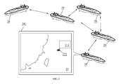
- the maritime climate information system 2 comprises a detecting device 21, a positioning device 22, a first maritime wireless network device 23, and a plurality of second maritime wireless network devices 24.
- the detecting device 21 is disposed on a first maritime vehicle 28 for detecting climate information 211 around the first maritime vehicle 28.
- the detecting device 21 is preferred to be a camera for catching a sea image or sky image around the first maritime vehicle 28; or a meteorograph for measuring the wind velocity, wind direction, temperature or atmospheric pressure around the first maritime vehicle 28; or any electronic device which can measure/catch physical quantity of climate information or maritime environment information and convert the physical quantity or information into electronic signals.
- Positioning device 22 is disposed on the first maritime vehicle 28 to calculate a coordinate 221 of the first maritime vehicle 28.
- the positioning device 22 can be a GPS device which receives satellite signals from at least three positioning satellites, and calculating the longitude data and latitude data of the GPS device itself according to these satellite signals. Therefore, if the GPS device is fixed on the first maritime vehicle 28, then the calculated longitude data and latitude data can be regarded as the longitude data and latitude data of the first maritime vehicle 28.
- the first maritime wireless device 23 is disposed on the first maritime vehicle 28, and used for transmitting the climate information 211 and coordinate 221.
- These second maritime wireless network devices 24 are respectively disposed on a plurality of second maritime vehicles 29, and are respectively wirelessly connected to the first maritime wireless device 23 to receive the climate information 211 and coordinate 221.
- at least a second maritime wireless network device 24 has a first operating interface 241 for displaying a local electronic map 25 around coordinate 221.
- the climate information 211 can be displayed at the position corresponding to the coordinate 221 on the local electronic map 25.
- Figure 3 illustrates the ocean area at the east north of Taiwan where the first maritime vehicle 28 is located, and the climate information 211 containing climate images is displayed at the coordinate 221.
- the first maritime vehicle 28 or the second maritime vehicle 29 can be a ship, a maritime platform or a floating maritime structure.
- the maritime wireless device comprises an antenna module, a plurality of circuit modules for receiving and transmitting signals, and a switch.
- the antenna module can be a directional antenna, an Omni-directional antenna, or a combination of both.
- the operation band of these antennas can cover 5175 MHz ⁇ 5875 MHz, for example, the antenna for WiFi communication, but this is just an example, not for limitation.
- the circuit module receiving and transmitting signals can be an access point (AP).
- the switch can be a data link layer switch, also called a second layer switch.
- the wireless signals transmission between the first maritime wireless network device 23 and the second maritime wireless network device 24 is operated with a wireless communication protocol, such as a WiFi communication protocol, a WiMAX communication protocol, a VHF communication protocol, or a UHF communication protocol.
- first maritime wireless network device 23 and second maritime wireless network device 24 can transmit wireless data to each other with Real Time Protocol (RTP) if necessary, so as to ensure that the climate information 211 which is displayed by the first operatinginterface 241 is instant.
- RTP Real Time Protocol
- FIG. 4 and Figure 5 are respectively a block diagram and a schematic diagram of a maritime climate information system according to a second embodiment of the present invention.
- the maritime climate information system 4 comprises a camera 41, a meteorograph 42, a GPS device 43, a first maritime wireless network 44, a plurality of second maritime wireless devices 45 and a climate information platform 46.
- the camera 41, the meteorograph 42, the GPS device 43, and the first maritime wireless network 44 are disposed on a first ship 48.
- the camera 41 is used to capture the climate image 411, such as a sea image or sky image around the first ship 48.
- the meteorograph 42 is used to measure the climatic statistics 421, such as the wind velocity, wind direction, temperature or atmospheric pressure around the first ship 48.
- the GPS device 43 receives the signals of the positioning satellite to calculate the current longitude and latitude data 431 of the location of the first ship 48.
- a plurality of second maritime wireless network devices 45 are respectively disposed on a plurality of second ships 49.
- the first maritime wireless network device 44 is wirelessly connected to at least one second maritime wireless device 45 to form a maritime network structure.
- these second maritime wireless devices 45 are also connected to at least one on-land wireless network device 47 and transmit the climate image 411, the measured climatic statistics 421 and longitude and latitude data 431 to every on-land wireless network device 47.
- at least one second maritime wireless network device 45 can further comprise a first operating interface 451 for displaying a local electronic map around the coordinate of the first ship 48, and the climate image 411 around the coordinate of the first ship 48 can be displayed on local electronic map.
- the climate information platform 46 may have a connection with every on-land wireless network device 47 via the Internet or intranet for receiving climate image 411, climatic statistics 421 and longitude data and latitude data 431. Besides, the climate information platform 46 comprises a second operating interface 461 for displaying a global electronic map 462, and climate image 411 and climatic statistics 421 are displayed at the location of longitude data and latitude data 431 on global electronic map 462.
- FIG 6 and Figure 7 are schematic diagrams which illustrate respectively an example of a second operating interface 461 displaying a global electronic map.
- the user can select a ship to be observed.
- the second operating interface 461 displays the climate images around the ship A1 at the place corresponding to the longitude and latitude of the location of the ship A1.
- the displayed ship A1 is located on North Atlantic Ocean.
- the displayed ship A2 is located on Indian Ocean.
- the climate images are displayed on the corresponding location, so that users can observe maritime climate more intuitionally.
- the more cameras are disposed on the ship the more climate images are displayed by the climate information platform 46.
- the second operating interface 461 also displays received climatic statistics, such as the temperature, humidity, wind direction, and wind velocity of the surroundings near the ship, and so on.
- the climate information platform 46 can be a webpage server. Users can operate a networking device to connect to this webpage server via the Internet. Thus, the user can operate the second operating interface 461 and observe the climate information on the browser. Besides, the wireless signal transmission between the first maritime wireless network device 44 and second maritime wireless network device 45, and between the second maritime wireless network device 45 and on-land wireless network device 47 can be operated with Real Time Protocol if necessary, so as to ensure that the climate image 411 and climatic statistics 421 which are displayed by the second interface 461 are instant.
- the climate image 411 and climatic statistics 421 at the places sailed by the first ship 48 can be all transmitted to the climate information platform 46. If a plurality of ships 48 sail on most of the global channels, the maritime climate information system 4 can collect the climate information on these channels effectively, and the collected maritime climate information can nearly cover all ocean area of the whole world. Compared with the conventional art of the meteorological cloud-chart, or isobaric chart, the climate image 411 and the climate statistics 421 collected by maritime climate information system 4 can provide users with more detailed information, which allows users to make more correct judgment.
- the climate information platform can further comprise a data analysis device if necessary.
- the data analysis device is for analyzing the received climate images and climatic statistics of all ships.
- the analysis can comprise, for example, prediction for climate information in large marine areas, suggestion of analyzing ship channels, or estimation of navigation risks, etc.
- the climate information platform can transmit the analyzed results back to the first vehicle (the first ship) or the second vehicle (the second ship) via the said on-land network devices and the paths of transmitting maritime wireless signals.
- Figure 8 is a flow diagram of a method for collecting and processing maritime climate information according to a first embodiment of the present invention.
- the method comprises the following steps.
- the detecting device and positioning device of the first vehicle are used to detect the surrounding climate information of the first vehicle and calculate the coordinate of the first vehicle.
- the detecting device can comprise a camera or a meteorograph.
- the positioning device can comprise a GPS device.
- the second maritime wireless network device of at least one second maritime vehicle is used to wirelessly connect to the first maritime wireless network device of the first maritime vehicle for receiving the climate information and the coordinate.
- the maritime vehicle can be a ship, a maritime platform or a floating maritime structure.
- a first operating interface of the second maritime wireless network device is used to display a local electronic map, and the climate information is displayed on this local electronic map.
- the maritime wireless device is preferred to comprise an antenna module, a plurality of circuit modules for receiving and transmitting signals, and a switch.
- the antenna module can be a directional antenna, a omni-directional antenna, or a combination of both.
- the operation bandwidth of these antennas can cover 5175 MHz ⁇ 5875 MHz, for example, the antenna for WiFi communication, but this is just an example, not for limitation.
- the circuit module for receiving and transmitting signals can be an access point (AP).
- the switch can be a data link layer switch, also called a second layer switch.
- the wireless signals transmission between the first maritime wireless network device 23 and the second maritime wireless network device 24 is operated with a wireless communication protocol, such as a WiFi communication protocol, a WiMAX communication protocol, a VHF communication protocol, or a UHF communication protocol.
- a wireless communication protocol such as a WiFi communication protocol, a WiMAX communication protocol, a VHF communication protocol, or a UHF communication protocol.
- FIG. 9 is a schematic diagram of a method for collecting and processing the maritime climate information according to a second embodiment of the present invention.
- this method comprises the following steps.
- step 71 the camera, meteorograph, GPS device of the first ship are used to detect the climate images and climatic statistics surrounding the first ship and calculate the longitude and latitude data of the location of the first ship.
- the second maritime wireless network device of at least one second ship is used to wirelessly connect to the first maritime wireless network device of the first ship for receiving the climate images, climatic statistics and the longitude and latitude data of the location of the first ship.
- At least one second maritime wireless network device is wirelessly connected to at least one on-land wireless network device.
- the climate information, climatic statistics and coordinate are transmitted to each on-land wireless network device.
- a climate information platform is used to connect to each on-land wireless network device for receiving the climate images, climatic statistics and the longitude and latitude data of the location of the first ship.
- the climate information platform comprises a second operating interface.
- a global electronic map is displayed on the second operating interface.
- the received climate images and climatic statistics are displayed on the place corresponding to the coordinate of the location of the first ship on the global electronic map.
- the climate information platform can be a webpage server and the user can operate a networking device to connect to this webpage server via the Internet. Thereby, the user can operate the second operating interface and observe climate information on the browser.
- the data analysis device of the climate information platform is used to analyze the maritime information according to the received climate images and climatic statistics from all ships.
- the analysis can comprise, for example, prediction for climate information in large marine areas, suggestion of analyzing ship channels, or estimation of navigation risks.
- the analyzed results are transmitted back to the first ship or the second ship via the on-land network devices, the first maritime wireless network device, and the second maritime wireless network device.
Landscapes
- Engineering & Computer Science (AREA)
- Databases & Information Systems (AREA)
- Environmental & Geological Engineering (AREA)
- Theoretical Computer Science (AREA)
- Physics & Mathematics (AREA)
- Biodiversity & Conservation Biology (AREA)
- General Physics & Mathematics (AREA)
- Data Mining & Analysis (AREA)
- Remote Sensing (AREA)
- Life Sciences & Earth Sciences (AREA)
- Atmospheric Sciences (AREA)
- General Engineering & Computer Science (AREA)
- Ecology (AREA)
- Environmental Sciences (AREA)
- Mobile Radio Communication Systems (AREA)
- Traffic Control Systems (AREA)
- Telephone Function (AREA)
- Telephonic Communication Services (AREA)
Applications Claiming Priority (1)
| Application Number | Priority Date | Filing Date | Title |
|---|---|---|---|
| TW097120316A TW200949751A (en) | 2008-05-30 | 2008-05-30 | Maritime climate information system and method for collecting and processing maritime climate information |
Publications (2)
| Publication Number | Publication Date |
|---|---|
| EP2128656A2 true EP2128656A2 (de) | 2009-12-02 |
| EP2128656A3 EP2128656A3 (de) | 2010-10-27 |
Family
ID=41064775
Family Applications (1)
| Application Number | Title | Priority Date | Filing Date |
|---|---|---|---|
| EP09161158A Withdrawn EP2128656A3 (de) | 2008-05-30 | 2009-05-26 | Meeresklima-Informationssystem und Verfahren zur Erfassung und Verarbeitung von Meeresklimadaten |
Country Status (3)
| Country | Link |
|---|---|
| US (1) | US20090295626A1 (de) |
| EP (1) | EP2128656A3 (de) |
| TW (1) | TW200949751A (de) |
Families Citing this family (9)
| Publication number | Priority date | Publication date | Assignee | Title |
|---|---|---|---|---|
| KR101289349B1 (ko) * | 2013-03-11 | 2013-07-29 | (주)동하테크 | 해양 네비게이션시스템 |
| US9275349B2 (en) | 2013-07-19 | 2016-03-01 | Ricoh Company Ltd. | Healthcare system integration |
| US9262728B2 (en) * | 2013-07-19 | 2016-02-16 | Ricoh Company Ltd. | Auto insurance system integration |
| US10251382B2 (en) * | 2013-08-21 | 2019-04-09 | Navico Holding As | Wearable device for fishing |
| US9507562B2 (en) | 2013-08-21 | 2016-11-29 | Navico Holding As | Using voice recognition for recording events |
| KR102254601B1 (ko) * | 2014-10-24 | 2021-05-21 | 한국전자통신연구원 | 멀티홉 릴레이 선박 통신 장치 |
| US9836129B2 (en) | 2015-08-06 | 2017-12-05 | Navico Holding As | Using motion sensing for controlling a display |
| US10948577B2 (en) | 2016-08-25 | 2021-03-16 | Navico Holding As | Systems and associated methods for generating a fish activity report based on aggregated marine data |
| US12007512B2 (en) | 2020-11-30 | 2024-06-11 | Navico, Inc. | Sonar display features |
Family Cites Families (8)
| Publication number | Priority date | Publication date | Assignee | Title |
|---|---|---|---|---|
| FR2802691B1 (fr) * | 1999-12-21 | 2002-03-22 | Thomson Csf | Procede de surveillance maritime |
| ES2276827T3 (es) * | 2000-09-27 | 2007-07-01 | Aerosat Corporation | Sistema de comunicacion para plataformas moviles. |
| US6778809B2 (en) * | 2001-04-03 | 2004-08-17 | Nobuyoshi Morimoto | Mobile network for remote service areas using mobile stations |
| EP1642424B1 (de) * | 2003-07-04 | 2008-01-16 | BRITISH TELECOMMUNICATIONS public limited company | Ad-hoc kommunikationssystem |
| EP1727106A1 (de) * | 2005-05-27 | 2006-11-29 | BRITISH TELECOMMUNICATIONS public limited company | Drahtloses Telemetriesystem |
| US7440848B2 (en) * | 2006-05-30 | 2008-10-21 | Horizon Marine | Methods and systems for integrating environmental data with mobile asset tracking |
| EP1926255A1 (de) * | 2006-11-24 | 2008-05-28 | Hsin-Chi Su | Ortungs- und Aufzeichnungsinformationssystem mit Multihop-Mitteln zur Rettung auf See |
| US7698024B2 (en) * | 2007-11-19 | 2010-04-13 | Integrated Power Technology Corporation | Supervisory control and data acquisition system for energy extracting vessel navigation |
-
2008
- 2008-05-30 TW TW097120316A patent/TW200949751A/zh unknown
-
2009
- 2009-05-21 US US12/470,054 patent/US20090295626A1/en not_active Abandoned
- 2009-05-26 EP EP09161158A patent/EP2128656A3/de not_active Withdrawn
Non-Patent Citations (3)
| Title |
|---|
| "Ship tracking", 16 May 2008 (2008-05-16), XP055027655, Retrieved from the Internet <URL:http://web.archive.org/web/20080516030423/http://www.sailwx.info/shiptrack/shiplocations.phtml> [retrieved on 20120521] * |
| "The WMO Voluntary Observing Ships (VOS) Scheme", 24 October 2003 (2003-10-24), XP055027639, Retrieved from the Internet <URL:http://web.archive.org/web/20031024042927/http://www.vos.noaa.gov/vos_scheme.shtml> [retrieved on 20120521] * |
| "YOTREPS", 21 May 2008 (2008-05-21), XP055027683, Retrieved from the Internet <URL:http://web.archive.org/web/20080521224200/http://www.pangolin.co.nz/yotreps/index.php> [retrieved on 20120521] * |
Also Published As
| Publication number | Publication date |
|---|---|
| TW200949751A (en) | 2009-12-01 |
| EP2128656A3 (de) | 2010-10-27 |
| US20090295626A1 (en) | 2009-12-03 |
Similar Documents
| Publication | Publication Date | Title |
|---|---|---|
| EP2128656A2 (de) | Meeresklima-Informationssystem und Verfahren zur Erfassung und Verarbeitung von Meeresklimadaten | |
| EP1597841B1 (de) | Verfahren und system zur überwachung der positionsbestimmungsleistung eines mobilen kommunikationsendgeräts unter verwendung eines drahtlosen kommunikationsnetzes und a-gps | |
| US9291695B2 (en) | Real-time RF signal visualization device | |
| CN103150786B (zh) | 一种非接触式无人驾驶车辆行驶状态测量系统及测量方法 | |
| JP2007232690A (ja) | 現在地検出装置、地図表示装置、および現在地検出方法 | |
| US9767534B2 (en) | Device, program and method for displaying situation | |
| KR20160105065A (ko) | 표류부이를 통한 실시간 해양 환경 관측 데이터 제공 시스템 및 그 방법 | |
| US20150206330A1 (en) | Weather information display system, human navigation device, and method of displaying weather information | |
| US20150302622A1 (en) | Weather information display system, human navigation device, and method of displaying weather information | |
| KR101180428B1 (ko) | 위성항법시스템 위치정보의 특정지역 신뢰도 제공 시스템 | |
| RU2011126307A (ru) | Многофункциональный мобильный комплекс обеспечения потребителей мониторинговой информацией (мкопми) | |
| KR101920707B1 (ko) | 영상정보 기반의 스마트 항적 정보 생성 장치 및 그 생성방법 | |
| JP4509775B2 (ja) | ラジオゾンデ・システム、ラジオゾンデ・システム受信機、およびラジオゾンデ受信機における信号処理方法 | |
| CN115311900B (zh) | 一种基于视觉增强的内河航道船舶辅助目标识别方法 | |
| US9542717B2 (en) | Display device and information collecting method using the same | |
| KR100436922B1 (ko) | 선박 추적정보 위성 전송 방법 | |
| KR20100028189A (ko) | 지피에스 기반 위치 결정 방법 및 장치 | |
| JP2009236545A (ja) | 画像処理装置及び画像処理システム及び画像処理方法及び画像処理プログラム | |
| CN100574150C (zh) | 利用无线通信网络和a-gps来监控移动终端位置确定性能的方法和系统 | |
| CN101598814A (zh) | 海上气候资讯系统及其海上气候资讯收集及处理方法 | |
| KR20150019085A (ko) | 위치 측정 시스템 및 그 방법 | |
| WO2018161331A1 (zh) | 无人机环境监测系统和监测方法 | |
| CN115164825B (zh) | 一种基于ads-b的自动数字引导系统 | |
| JP2006284434A (ja) | 流速観測システムおよび漂流ブイ | |
| Nazila et al. | Real-Time Vessel Monitoring Using Low Cost RTL-SDR with Web-Based AIS Visualization |
Legal Events
| Date | Code | Title | Description |
|---|---|---|---|
| PUAI | Public reference made under article 153(3) epc to a published international application that has entered the european phase |
Free format text: ORIGINAL CODE: 0009012 |
|
| AK | Designated contracting states |
Kind code of ref document: A2 Designated state(s): AT BE BG CH CY CZ DE DK EE ES FI FR GB GR HR HU IE IS IT LI LT LU LV MC MK MT NL NO PL PT RO SE SI SK TR |
|
| PUAL | Search report despatched |
Free format text: ORIGINAL CODE: 0009013 |
|
| AK | Designated contracting states |
Kind code of ref document: A3 Designated state(s): AT BE BG CH CY CZ DE DK EE ES FI FR GB GR HR HU IE IS IT LI LT LU LV MC MK MT NL NO PL PT RO SE SI SK TR |
|
| RIC1 | Information provided on ipc code assigned before grant |
Ipc: G01W 1/00 20060101AFI20090929BHEP Ipc: G08G 1/123 20060101ALI20100917BHEP |
|
| 17P | Request for examination filed |
Effective date: 20110427 |
|
| 17Q | First examination report despatched |
Effective date: 20120529 |
|
| STAA | Information on the status of an ep patent application or granted ep patent |
Free format text: STATUS: THE APPLICATION IS DEEMED TO BE WITHDRAWN |
|
| 18D | Application deemed to be withdrawn |
Effective date: 20121009 |