EP2189755A1 - System und Anzeigeelement zur Anzeige von Wegpunktmarkierungen mit integrierten Höhenbeschränkungsinformationen - Google Patents
System und Anzeigeelement zur Anzeige von Wegpunktmarkierungen mit integrierten Höhenbeschränkungsinformationen Download PDFInfo
- Publication number
- EP2189755A1 EP2189755A1 EP09176228A EP09176228A EP2189755A1 EP 2189755 A1 EP2189755 A1 EP 2189755A1 EP 09176228 A EP09176228 A EP 09176228A EP 09176228 A EP09176228 A EP 09176228A EP 2189755 A1 EP2189755 A1 EP 2189755A1
- Authority
- EP
- European Patent Office
- Prior art keywords
- waypoint
- altitude
- aircraft
- terrain
- data
- Prior art date
- Legal status (The legal status is an assumption and is not a legal conclusion. Google has not performed a legal analysis and makes no representation as to the accuracy of the status listed.)
- Granted
Links
Images


Classifications
-
- G—PHYSICS
- G01—MEASURING; TESTING
- G01C—MEASURING DISTANCES, LEVELS OR BEARINGS; SURVEYING; NAVIGATION; GYROSCOPIC INSTRUMENTS; PHOTOGRAMMETRY OR VIDEOGRAMMETRY
- G01C23/00—Combined instruments indicating more than one navigational value, e.g. for aircraft; Combined measuring devices for measuring two or more variables of movement, e.g. distance, speed or acceleration
- G01C23/005—Flight directors
-
- G—PHYSICS
- G01—MEASURING; TESTING
- G01C—MEASURING DISTANCES, LEVELS OR BEARINGS; SURVEYING; NAVIGATION; GYROSCOPIC INSTRUMENTS; PHOTOGRAMMETRY OR VIDEOGRAMMETRY
- G01C23/00—Combined instruments indicating more than one navigational value, e.g. for aircraft; Combined measuring devices for measuring two or more variables of movement, e.g. distance, speed or acceleration
-
- G—PHYSICS
- G06—COMPUTING OR CALCULATING; COUNTING
- G06T—IMAGE DATA PROCESSING OR GENERATION, IN GENERAL
- G06T11/00—Two-dimensional [2D] image generation
- G06T11/20—Drawing from basic elements
-
- G—PHYSICS
- G06—COMPUTING OR CALCULATING; COUNTING
- G06T—IMAGE DATA PROCESSING OR GENERATION, IN GENERAL
- G06T19/00—Manipulating three-dimensional [3D] models or images for computer graphics
- G06T19/003—Navigation within 3D models or images
-
- G—PHYSICS
- G06—COMPUTING OR CALCULATING; COUNTING
- G06T—IMAGE DATA PROCESSING OR GENERATION, IN GENERAL
- G06T7/00—Image analysis
- G06T7/70—Determining position or orientation of objects or cameras
-
- G—PHYSICS
- G08—SIGNALLING
- G08G—TRAFFIC CONTROL SYSTEMS
- G08G5/00—Traffic control systems for aircraft
- G08G5/20—Arrangements for acquiring, generating, sharing or displaying traffic information
- G08G5/21—Arrangements for acquiring, generating, sharing or displaying traffic information located onboard the aircraft
Definitions
- a flight deck display element having rendered thereon a perspective view of terrain corresponding to a viewpoint from the flight deck, and having rendered thereon a waypoint marker in the perspective view of terrain.
- the waypoint marker corresponds to a waypoint in a flight plan, and the waypoint marker includes a primary icon representing the waypoint and a first altitude bar indicative of a first altitude constraint associated with the waypoint.
- the perspective view of terrain, the primary icon, and the first altitude bar are rendered in a conformal manner relative to the earth.
- FIG. 7 is a schematic representation of a waypoint marker associated with an at-or-below constraint
- Coupled means that one element/node/feature is directly or indirectly joined to (or directly or indirectly communicates with) another element/node/feature, and not necessarily mechanically.
- FIG. 1 depicts one exemplary arrangement of elements, additional intervening elements, devices, features, or components may be present in an embodiment of the depicted subject matter.
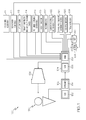
- FIG. 1 depicts an exemplary flight deck display system 100 that generally includes, without limitation: a user interface 102; a processor architecture 104 coupled to user interface 102; and a display element 106 coupled to processor architecture 104.
- System 100 may also include, cooperate with, and/or communicate with a number of databases, sources of data, or the like.
- system 100 may include, cooperate with, and/or communicate with a number of external subsystems as described in more detail below.
- User interface 102 is in operable communication with processor architecture 104 and is configured to receive input from a user 130 (e.g., a pilot) and, in response to the user input, supply command signals to processor architecture 104.
- User interface 102 may be any one, or combination, of various known user interface devices including, but not limited to, a cursor control device (CCD) 132, such as a mouse, a trackball, or joystick, one or more buttons, switches, or knobs.
- CCD cursor control device
- user interface 102 includes CCD 132 and a keyboard 134.
- the user 130 manipulates CCD 132 to, among other things, move cursor symbols that might be rendered at various times on display element 106, and the user 130 may manipulate keyboard 134 to, among other things, input textual data.
- user interface 102 may also be utilized to enable user interaction with navigation computer 112, the flight management system, and/or other features and components of the aircraft.
- Processor architecture 104 is in operable communication with terrain database 108, navigation database 110, and display element 106, and is coupled to receive various types of data, information, commands, signals, etc., from the various sensors, data sources, instruments, and subsystems described herein.
- processor architecture 104 is suitably configured to obtain and process avionics-related data as needed to generate a graphical and perspective (three dimensional) representation of terrain and waypoint markers having the features and characteristics described below with reference to FIGS. 3-9 .
- processor architecture 104 is configured to respond to inertial data obtained by inertial sensors 126 to selectively retrieve terrain data from terrain database 108 or terrain sensor 128 and navigation data from navigation database 110. Processor architecture 104 can also supply appropriate display commands to display element 106, so that the retrieved terrain and navigation data are appropriately displayed on display element 106. Processor architecture 104 is further configured to receive airspeed, altitude, waypoint, and geographic position data for the aircraft and, based upon that data, generate image rendering commands associated with the display of terrain and waypoint markers (that include graphical representations of position-dependent altitude constraint information). The preferred manner in which the waypoints and constraint data are displayed on display element 106 will be described in more detail further below.
- the terrain data provided to processor architecture 104 is a combination of data from terrain database 108 and terrain sensor 128.
- processor architecture 104 can be programmed to retrieve certain types of terrain data from terrain database 108 and other certain types of terrain data from terrain sensor 128.
- terrain data retrieved from terrain sensor 128 can include moveable terrain, such as mobile buildings and systems. This type of terrain data is better suited for terrain sensor 128 to provide the most up-to-date data available.
- types of information such as waterbody information and geopolitical boundaries can be provided by terrain database 108.
- terrain sensor 128 detects, for example, a waterbody, the existence of such can be confirmed by terrain database 108 and rendered in a particular color such as blue by processor architecture 104.
- Navigation database 110 includes various types of navigation-related data stored therein.
- navigation database 110 is an onboard database that is carried by the aircraft.
- the navigation-related data include various flight plan related data such as, for example, and without limitation: waypoint location data for geographical waypoints; restricted, constrained, or target altitude values (such as target altitudes, upper altitude limits, or lower altitude limits) corresponding to geographical waypoints; distances between waypoints; track between waypoints; restricted, constrained, or target airspeed values (such as target airspeeds, upper airspeed limits, or lower airspeed limits) corresponding to geographical waypoints; data related to different airports; navigational aids; obstructions; special use airspace; restricted, constrained, or target altitude/airspeed values corresponding to special use airspace; political boundaries; communication frequencies; and aircraft approach information.
- waypoint location data for geographical waypoints
- restricted, constrained, or target altitude values such as target altitudes, upper altitude limits, or lower altitude limits
- target airspeed values such as target air
- terrain database 108 and navigation database 110 are, for clarity and convenience, shown as being stored separate from processor architecture 104, all or portions of either or both of these databases 108, 110 could be loaded into the onboard RAM 136, stored in ROM 138, or integrally formed as part of processor architecture 104. Terrain database 108 and navigation database 110 could also be part of a device or system that is physically separate from system 100.
- Positioning subsystem 111 is suitably configured to obtain position data for the aircraft.
- positioning subsystem 111 monitors the current position of the aircraft in real-time, and the real-time position data can be used by one or more other subsystems, processing modules, or equipment on the aircraft (e.g., navigation computer 112, RAAS 114, ILS 116, flight director 118, TAWS 122, or TCAS 124).
- positioning subsystem 111 is realized using global positioning system (GPS) technologies that are commonly deployed in avionics applications.
- GPS global positioning system
- the position data obtained by positioning subsystem 111 may represent the latitude and longitude of the aircraft in an ongoing and continuously updated manner.
- the weather data 120 supplied to processor architecture 104 is representative of at least the location and type of various weather cells.
- the data supplied from TCAS 124 includes data representative of other aircraft in the vicinity, which may include, for example, speed, direction, altitude, and altitude trend.
- processor architecture 104 in response to the TCAS data, supplies appropriate display commands to display element 106 such that a graphic representation of each aircraft in the vicinity is displayed on display element 106.
- TAWS 122 supplies data representative of the location of terrain that may be a threat to the aircraft.
- Processor architecture 104 in response to the TAWS data, preferably supplies appropriate display commands to display element 106 such that the potential threat terrain is displayed in various colors depending on the level of threat.
- red is used for warnings (immediate danger)
- yellow is used for cautions (possible danger)
- green is used for terrain that is not a threat. It will be appreciated that these colors and number of threat levels are merely exemplary, and that other colors and different numbers of threat levels can be provided as a matter of choice.
- ILS 116 is a radio navigation system that provides the aircraft with horizontal and vertical guidance just before and during landing and, at certain fixed points, indicates the distance to the reference point of landing.
- the system includes ground-based transmitters (not shown) that transmit radio frequency signals.
- ILS 116 onboard the aircraft receives these signals and supplies appropriate data to the processor for display of, for example, an ILS feather (not shown in FIG. 1 ) on the display element 106.
- the ILS feather represents two signals, a localizer signal that is used to provide lateral guidance, and a glide slope signal that is used for vertical guidance.
- Aural advisories which may be issued by RAAS 114, inform the user 130, among other things of when the aircraft is approaching a runway, either on the ground or from the air at times such as when the aircraft has entered and is aligned with a runway, when the runway is not long enough for the particular aircraft, the distance remaining to the end of the runway as the aircraft is landing or during a rejected takeoff, when the user 130 inadvertently begins to take off from a taxiway, and when an aircraft has been immobile on a runway for an extended time.
- sources such as GPS, including RNP and RNAV, can also be considered.
- Navigation computer 112 is used, among other things, to allow the user 130 to program a flight plan from one destination to another.
- Navigation computer 112 may be in operable communication with flight director 118.
- flight director 118 may be used to automatically fly, or assist the user 130 in flying, the programmed route.
- Navigation computer 112 is in operable communication with various databases including, for example, terrain database 108, and navigation database 110.
- Processor architecture 104 may receive the programmed flight plan data from navigation computer 112 and cause the programmed flight plan, or at least portions thereof, to be displayed on display element 106.
- FIG. 2 is a simplified chart that illustrates a flight plan 200 of an aircraft 202 relative to three geographical waypoints.
- the vertical axis represents altitude in feet, and the horizontal axis represents lateral position or distance, and the chart depicts aircraft 202 in a descent pattern.
- each geographical waypoint corresponds to a stationary reference point, which may in turn correspond to a designated latitude and longitude, a designated set of GPS coordinates, or the like.
- FIG. 2 shows that aircraft 202 has already passed a first geographical waypoint 204 identified by the label WASAK, and that aircraft 202 is approaching a second geographical waypoint 206 identified by the label LACIV.
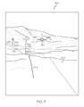
- FIG. 3 is a graphical representation of an exemplary screen shot 300 that can be rendered on a flight deck display element. It should be appreciated that this screen shot 300 represents the state of a dynamic display frozen at one particular time, and that the flight deck display element can be continuously refreshed in response to the current flight status, environmental conditions, location of the aircraft, etc.
- This particular screen shot 300 includes several primary features that are graphically rendered. These features include, without limitation: a perspective view of terrain 302; a waypoint marker 304; an airspeed tape 306; an altimeter tape 308; a compass or horizontal situation indicator 310; a reference marker 312; and flight plan indicia 314.
- a flight deck display system may also render a lateral situation display element concurrently with the main perspective display.
- FIG. 4 is a schematic representation of an embodiment of such a graphical lateral situation display element 400.
- Lateral situation display element 400 can display information based on data from a number of sources, including the various sensors, sources, and subsystems described above with reference to FIG. 1 .
- the lateral situation display element 400 includes a top-view aircraft symbol 402, at least portion of a flight plan represented by one or more waypoint symbols 404, and one or more range rings 406.
- Lateral situation display element 400 also preferably includes various map features including, but not limited to, a lateral two-dimensional view of terrain 408 below the flight plan, political boundaries, and navigation aids.
- Range rings 406 may be used to indicate sequential ranges, such as fixed distance or time ranges needed to travel from the current position indicated by the top-view aircraft symbol 402 to another position on the terrain 408, or any other information that may be useful to a pilot.
- the range rings 406 indicate distances from the aircraft symbol 402.
- the range ring 406 includes a range indicator 410, which displays the lateral distance from the present position to the position that corresponds to the range ring 406 (e.g., 10 nautical miles).
- FIG. 5 depicts a simplified graphical representation of screen shot 300.
- some of the displayed elements shown in FIG. 3 have been removed to better show the waypoint markers and flight plan indicia, which might otherwise be obscured or overlapped by elements that remain displayed "on top” in the perspective display.
- FIG. 5 shows another waypoint marker 320 that is hidden from view in FIG. 3 due to the rendering of airspeed tape 306.
- waypoint marker 304 corresponds to the geographical waypoint labeled LACIV
- waypoint marker 320 corresponds to the geographical waypoint labeled FIVUT.
- LACIV is the immediately approaching waypoint for the aircraft
- FIVUT is the waypoint immediately following LACIV in the designated flight plan.
- waypoint marker 304 may be joined to flight plan indicia 314 using a displayed stem or stalk 322.
- waypoint marker 320 may be joined to flight plan indicia 314 using a displayed stem or stalk 324.
- Each stalk "pins" its waypoint marker to the geographic location of the corresponding waypoint.
- the displayed height of each stalk might correspond to an altitude constraint or restriction associated with the respective waypoint.
- FIG. 5 depicts a scenario where the aircraft is in a descent pattern and, therefore, waypoint marker 304 is displayed at a higher elevation than waypoint marker 320. It should be noted that a waypoint need not have any constraints associated with it.
- a waypoint may have an arbitrary altitude value associated therewith for purposes of positioning the waypoint marker on the perspective display.
- the system may be configured to generate a graphical waypoint marker in the current display (regardless of whether or not an altitude constraint applies) when the aircraft is within a certain distance from the waypoint.
- the flight deck display system may also change the appearance of the waypoint markers 304/320, the stalks 322/324, and/or the flight plan indicia 314 to convey additional information to the flight crew.
- certain displayed elements may be rendered using a distinguishable color, font, size, texture, transparency, or the like, and the distinguishable characteristic (or characteristics) may have contextually relevant meaning.
- Certain embodiments employ a color scheme associated with auto pilot control.
- an approaching waypoint marker and its stalk can be displayed in a first color (such as magenta) to indicate that the auto pilot subsystem is controlling the aircraft to satisfy the particular altitude constraint at that geographical waypoint or position.
- the segment of flight plan indicia 314 leading to the approaching waypoint marker can also be displayed in the first color.
- waypoint marker 304, stalk 322, and the segment of flight plan indicia 314 leading to waypoint marker 304 may be magenta colored to convey that the auto pilot subsystem is directing the aircraft toward the LACIV waypoint ( FIG. 5 depicts these magenta colored items using thick solid line).
- a second color (such as cyan or white) may be used to indicate an upcoming waypoint to which the auto pilot subsystem is not currently controlling.
- waypoint marker 320, stalk 324, and the associated segment of flight plan indicia 314 may be displayed using white or cyan to convey that the auto pilot subsystem is not yet (but soon will be) directing the aircraft toward the FIVUT waypoint.
- the graphical features associated with the FIVUT waypoint will change from white/cyan to magenta.
- a waypoint marker can be suitably rendered such that it conveys an altitude restriction, constraint, regulation, or limitation for its respective waypoint.
- An altitude constraint or restriction may be designated for a respective position, region, geographical waypoint, airspace boundary, airway, or the like.
- the data representing the altitude constraints may be included or otherwise associated with the onboard flight plan.
- the data representing the altitude constraints could be provided to the onboard system via, for example, ATC datalink 113 (see FIG. 1 ) for imbedding or incorporating into the onboard flight plan.
- the system described here contemplates at least four types of altitude constraints, although an embodiment of the system may handle more or less than four different types.
- the four constraints described here are "at-or-above,” “at-or-below,” “between,” and “specified altitude” (or “at”) constraints.
- An at-or-above constraint is associated with a lower altitude limit at that particular waypoint.
- An at-or-below constraint is associated with an upper altitude limit at that particular waypoint.
- a between constraint is associated with a specified altitude range, i.e., a designated upper altitude limit and a designated lower altitude limit for the waypoint.
- a specified altitude constraint indicates a target altitude (or a very restricted altitude range) for the waypoint.
- the content and/or appearance of a waypoint marker might be influenced by an altitude restriction for the corresponding waypoint.
- waypoint markers can be rendered using visually distinguishable characteristics associated with the different types of altitude constraints. The visually distinguishable characteristics can be specified such that the user can quickly and easily interpret the display to determine whether an approaching waypoint is governed by an altitude constraint and, if so, which type of altitude constraint applies (e.g., at-or-above, at-or-below, between, or specified altitude).
- the different visually distinguishable characteristics may correspond to any of the following characteristics, individually or in any combination thereof: different colors; different brightness; different transparency levels; different translucency levels; different line patterns; different line thickness; different shapes; different sizes; different flicker patterns; different focus levels; different sharpness levels; different clarity levels; and orientation/alignment of the waypoint marker (for example, relative to the flight path or relative to the user viewpoint).
- FIG. 6 is a schematic representation of a waypoint marker 500 associated with an at-or-above constraint for the waypoint labeled LACIV.
- waypoint marker 500 is preferably rendered in the perspective view of terrain (not shown in FIG. 6 ) in a conformal manner.
- Waypoint marker 500 indicates the target altitude for the at-or-above constraint, i.e., the lower altitude limit.
- Waypoint marker 500 represents the primary icon associated with the LACIV waypoint. This primary icon has a first region 504 (e.g., the upper region in FIG. 5 ) and a second region 506 (e.g., the lower region in FIG. 5 ). First region 504 and second region 506 have different visually distinguishable characteristics that represent the at-or-above nature of the altitude constraint.
- the dashed line portion of waypoint marker 500 is associated with first region 504, and the solid line portion of waypoint marker 500 is associated with second region 506.
- Waypoint marker 500 or selected portions thereof can be rendered as a "solid" form or in an "outlined” form (as depicted in FIG. 5 ). The outline format may be desirable to minimize the amount of terrain that is obscured by waypoint marker 500.
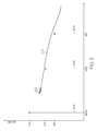
- FIG. 7 is a schematic representation of a waypoint marker 600 associated with an at-or-below constraint for a waypoint.
- Waypoint marker 600 indicates the target altitude for the at-or-below constraint, i.e., the upper altitude limit.
- waypoint marker 600 includes an altitude bar 602 that is displayed at the target altitude for the at-or-below constraint.
- altitude bar 602 is indicative of the nominal (target) altitude corresponding to the waypoint.
- altitude bar 602 is preferably positioned at or near the center of waypoint marker 600.
- the target altitude can be displayed in numerical form at or near altitude bar 602 or within waypoint marker 600.
- first region 604 of waypoint marker 600 is rendered with graphical characteristics that make it relatively highlighted, and second region 606 of waypoint marker 600 is rendered with graphical characteristics that make it relatively subdued.
- This subdued/highlighted scheme intuitively indicates that altitudes below altitude bar 602 are permitted or clear, while altitudes above altitude bar 602 are blocked or prohibited.
- first region 604 is rendered in a relatively opaque or solid manner, while second region 606 is rendered in a relatively transparent or translucent manner.
- first region 604 is rendered in a relatively bright manner, while second region 606 is rendered in a relatively dim manner.
- the manner in which first region 604 and second region 606 are distinctively rendered may vary from one embodiment to another.
- a waypoint marker can indicate a between constraint using any two altitude bars (or any two visible features).
- upper altitude bar 704 and altitude bar 708 can be rendered without lower altitude bar 706, while still conveying that waypoint marker 700 is associated with a between constraint.
- altitude bar 708 could instead be displayed at a virtual height that corresponds to the lower altitude limit.
- lower altitude bar 706 and altitude bar 708 can be rendered without upper altitude bar 704.
- altitude bar 708 could be displayed at a virtual height that corresponds to the upper altitude limit.
- Additional information associated with a given waypoint may be conveyed along with its associated waypoint marker. For example, if a waypoint corresponds to the initial approach fix for the aircraft, then the label "IAF" may be rendered with or near the corresponding waypoint marker. Similar labels can be displayed for the final approach fix ("FAF”) and for a missed approach point ("MAP"). As another example, an appropriate icon could be displayed with or near the waypoint marker to indicate the glideslope intercept. This icon may depict, for example, a lightning bolt with an arrowhead.
- the appearance of a waypoint marker may change when the geographic position of the aircraft is within close proximity to the immediately approaching geographical waypoint. This may be desirable to provide an early warning or notification to the pilot. Moreover, the appearance of a waypoint marker may change when the aircraft passes the targeted geographical waypoint, regardless of whether the auto pilot feature is active. Such a change in appearance will convey to the pilot that the current geographic position of the aircraft is beyond the geographic position of certain waypoints. In yet other embodiments, the appearance of a waypoint marker may change if the currently projected path of the aircraft does not satisfy the altitude restriction corresponding to the approaching waypoint.
- the waypoint marker for that particular waypoint may change to notify the pilot (e.g., it might change color, begin to flash on and off, or the like).
Landscapes
- Engineering & Computer Science (AREA)
- Physics & Mathematics (AREA)
- General Physics & Mathematics (AREA)
- Radar, Positioning & Navigation (AREA)
- Remote Sensing (AREA)
- Theoretical Computer Science (AREA)
- Aviation & Aerospace Engineering (AREA)
- Software Systems (AREA)
- Computer Graphics (AREA)
- Computer Hardware Design (AREA)
- General Engineering & Computer Science (AREA)
- Computer Vision & Pattern Recognition (AREA)
- Traffic Control Systems (AREA)
- Navigation (AREA)
- Instructional Devices (AREA)
- Automation & Control Theory (AREA)
Applications Claiming Priority (1)
| Application Number | Priority Date | Filing Date | Title |
|---|---|---|---|
| US12/275,950 US20100131126A1 (en) | 2008-11-21 | 2008-11-21 | System and display element for displaying waypoint markers with integrated altitude constraint information |
Publications (2)
| Publication Number | Publication Date |
|---|---|
| EP2189755A1 true EP2189755A1 (de) | 2010-05-26 |
| EP2189755B1 EP2189755B1 (de) | 2015-03-11 |
Family
ID=41600660
Family Applications (1)
| Application Number | Title | Priority Date | Filing Date |
|---|---|---|---|
| EP09176228.6A Active EP2189755B1 (de) | 2008-11-21 | 2009-11-17 | System und Anzeigeelement zur Anzeige von Wegpunktmarkierungen mit integrierten Höhenbeschränkungsinformationen |
Country Status (2)
| Country | Link |
|---|---|
| US (3) | US20100131126A1 (de) |
| EP (1) | EP2189755B1 (de) |
Cited By (7)
| Publication number | Priority date | Publication date | Assignee | Title |
|---|---|---|---|---|
| US20100023187A1 (en) * | 2008-07-28 | 2010-01-28 | Honeywell International Inc., | System and method for displaying constraint information on a graphical aircraft instrument tape element |
| EP2623935A1 (de) * | 2012-02-03 | 2013-08-07 | Honeywell International Inc. | System und Verfahren zur Anzeige von Reichweite- und Zeitskalen auf einer Navigationsanzeige |
| FR2996039A1 (fr) * | 2012-09-27 | 2014-03-28 | Airbus Operations Sas | Procede et dispositif d'aide a la gestion du vol d'un aeronef. |
| US9273964B2 (en) * | 2008-11-21 | 2016-03-01 | Honeywell International Inc. | System and display element for displaying waypoint markers with integrated altitude constraint information |
| EP3023741A1 (de) * | 2014-11-18 | 2016-05-25 | Honeywell International Inc. | System und verfahren zur exozentrischen anzeige von integrierter navigation |
| US9354077B2 (en) | 2008-05-20 | 2016-05-31 | Honeywell International Inc. | Navigation system |
| EP3236448A1 (de) * | 2016-04-19 | 2017-10-25 | Honeywell International Inc. | System und verfahren zur hervorhebung von geschwindigkeitsänderungs- und beschleunigungspunkten |
Families Citing this family (36)
| Publication number | Priority date | Publication date | Assignee | Title |
|---|---|---|---|---|
| US8285427B2 (en) * | 2008-07-31 | 2012-10-09 | Honeywell International Inc. | Flight deck communication and display system |
| US8380367B2 (en) * | 2009-03-26 | 2013-02-19 | The University Of North Dakota | Adaptive surveillance and guidance system for vehicle collision avoidance and interception |
| JP5916283B2 (ja) * | 2010-07-01 | 2016-05-11 | 三菱重工業株式会社 | 表示装置、操縦支援システム、及び表示方法 |
| GB2489685B (en) * | 2011-03-31 | 2017-01-25 | Geovs Ltd | A Display System |
| US9146133B2 (en) * | 2011-06-06 | 2015-09-29 | Honeywell International Inc. | Methods and systems for displaying procedure information on an aircraft display |
| US8712609B2 (en) | 2012-05-14 | 2014-04-29 | Honeywell International Inc. | Methods and systems for representing missed approach information in perspective view on a cockpit display |
| US9043136B2 (en) * | 2012-07-26 | 2015-05-26 | Ge Aviation Systems, Llc | Method for displaying suitability of future waypoint locations |
| US8965600B2 (en) * | 2012-07-26 | 2015-02-24 | Ge Aviation Systems, Llc | Method for displaying a flight plan |
| US8880339B1 (en) * | 2012-08-21 | 2014-11-04 | Rockwell Collins Inc. | Schematic display for vertical navigation |
| US8843306B1 (en) | 2012-11-28 | 2014-09-23 | The Boeing Company | Airspace fix formation display |
| US12260769B1 (en) | 2012-12-28 | 2025-03-25 | Otto Aero Company | System and apparatus for reducing the urgency of a flight condition |
| US9527601B2 (en) * | 2013-02-05 | 2016-12-27 | Honeywell International Inc. | Method and apparatus for generating a virtual inner marker for an aircraft landing approach |
| US9377325B2 (en) | 2013-03-18 | 2016-06-28 | Honeywell International Inc. | System and method for graphically displaying airspace speed data |
| US9126694B2 (en) * | 2013-07-15 | 2015-09-08 | Honeywell International Inc. | Display systems and methods for providing displays having an integrated autopilot functionality |
| FR3013444B1 (fr) * | 2013-11-19 | 2017-05-05 | Airbus Operations Sas | Procede et systeme d'affichage de phenomenes meteorologiques rencontres par un aeronef volant le long d'un plan de vol. |
| FR3019364B1 (fr) * | 2014-03-28 | 2016-03-18 | Airbus Operations Sas | Procede et systeme d'aide au pilotage d'un aeronef. |
| FR3020688B1 (fr) * | 2014-04-30 | 2016-05-06 | Thales Sa | Systeme de visualisation de tete comportant des moyens de selections de cap et procede de selection associe |
| US9704405B2 (en) | 2014-06-12 | 2017-07-11 | Honeywell International Inc. | Aircraft display systems and methods for providing an aircraft display for use with airport departure and arrival procedures |
| US9523580B2 (en) * | 2014-12-02 | 2016-12-20 | Honeywell International Inc. | System and method for aiding a pilot in locating an out of view landing site |
| WO2016149039A1 (en) * | 2015-03-17 | 2016-09-22 | Sikorsky Aircraft Corporation | Trajectory control of a vehicle |
| EP3286086A4 (de) * | 2015-04-22 | 2018-10-24 | Astronautics Corporation Of America | Elektronische anzeige von kompass-/karteninformationen für einen drehflügler zur verbesserten darstellung umgebender hindernisse |
| US9533617B2 (en) | 2015-05-01 | 2017-01-03 | Honeywell International Inc. | Collision avoidance system for high-performance non-commercial aircraft |
| US9464901B1 (en) * | 2015-05-28 | 2016-10-11 | Rockwell Collins, Inc. | RNP-scaled waypoint symbology generating system, device, and method |
| US9672747B2 (en) | 2015-06-15 | 2017-06-06 | WxOps, Inc. | Common operating environment for aircraft operations |
| US9564055B2 (en) * | 2015-06-15 | 2017-02-07 | WxOps, Inc. | Prediction and warning of transported turbulence in long-haul aircraft operations |
| US9702726B2 (en) * | 2015-11-16 | 2017-07-11 | Honeywell International Inc. | Enhanced instrument procedure visualization |
| FR3046224B1 (fr) * | 2015-12-23 | 2018-06-08 | Thales | Procede de representation graphique tridimensionnelle d'un axe de piste d'atterrissage |
| US10000297B2 (en) * | 2016-09-29 | 2018-06-19 | Honeywell International Inc. | Aircraft display systems and methods for generating horizontal situation indicator graphics with enhanced symbology |
| US10467912B2 (en) * | 2017-03-14 | 2019-11-05 | Honeywell International Inc. | System and method to revise vertical profile of a flight plan |
| FR3068490B1 (fr) * | 2017-06-30 | 2019-08-23 | Thales | Procede de calcul d'une trajectoire verticale d'un aeronef a partir de sa position courante, produit programme d'ordinateur et systeme de calcul associes |
| GB2568356B (en) * | 2017-09-07 | 2021-12-15 | Borealis Tech Ltd | Improved aircraft ground collision avoidance system |
| KR102734089B1 (ko) * | 2019-11-26 | 2024-11-25 | 국립군산대학교산학협력단 | 지적 측량 드론 및 이를 이용한 지적 측량 방법 |
| JP2021168005A (ja) * | 2020-04-09 | 2021-10-21 | エスゼット ディージェイアイ テクノロジー カンパニー リミテッドSz Dji Technology Co., Ltd | 表示制御方法、表示制御装置、プログラム、及び記録媒体 |
| US11332259B1 (en) | 2020-11-11 | 2022-05-17 | Honeywell International Inc. | Systems and methods for providing location information for a user-selected feature on an active vertical situation display (VSD) |
| US12122530B2 (en) | 2022-02-04 | 2024-10-22 | Honeywell International Inc. | Energy constraint management methods and systems |
| CN119124172B (zh) * | 2024-11-06 | 2025-06-17 | 南京航空航天大学 | 一种融合空域无人驾驶航空器飞行航路动态规划方法 |
Citations (4)
| Publication number | Priority date | Publication date | Assignee | Title |
|---|---|---|---|---|
| US6163743A (en) | 1996-02-02 | 2000-12-19 | Sextant Avionique | Process and device for aiding aerial navigation |
| US20040160341A1 (en) | 2003-02-18 | 2004-08-19 | Honeywell International, Inc. | Display methodology for encoding simultaneous absolute and relative altitude terrain data |
| EP1460384A2 (de) * | 2003-03-07 | 2004-09-22 | Airbus France | Verfahren und Vorrichtung zur Erstellung eines synthetischen Bildes der Umgebung eines Flugzeuges und dessen Darstellung auf einem Bildschirm dieses Flugzeugs |
| US6985801B1 (en) * | 2002-02-28 | 2006-01-10 | Garmin International, Inc. | Cockpit instrument panel systems and methods with redundant flight data display |
Family Cites Families (17)
| Publication number | Priority date | Publication date | Assignee | Title |
|---|---|---|---|---|
| US4021009A (en) * | 1975-07-24 | 1977-05-03 | Sperry Rand Corporation | Vertical path control for aircraft area navigation system |
| DE3930862A1 (de) * | 1989-09-15 | 1991-03-28 | Vdo Schindling | Verfahren und einrichtung zur darstellung von flugfuehrungsinformation |
| FR2689231B1 (fr) * | 1992-03-26 | 1996-09-27 | Aerospatiale Ste Nat Indle | Procede et dispositif d'assistance au pilotage d'un aerodyne par la representation graphique du plan de vol vertical de cet aerodyne |
| US6038498A (en) * | 1997-10-15 | 2000-03-14 | Dassault Aviation | Apparatus and mehod for aircraft monitoring and control including electronic check-list management |
| US6112141A (en) * | 1997-10-15 | 2000-08-29 | Dassault Aviation | Apparatus and method for graphically oriented aircraft display and control |
| US5978715A (en) * | 1997-10-15 | 1999-11-02 | Dassault Aviation | Apparatus and method for aircraft display and control |
| WO2000065423A2 (en) * | 1999-04-01 | 2000-11-02 | Price Ricardo A | Electronic flight instrument displays |
| US6995690B1 (en) * | 1999-07-30 | 2006-02-07 | The Boeing Company | Vertical situation display terrain/waypoint swath, range to target speed, and blended airplane reference |
| EP1091190A3 (de) * | 1999-09-14 | 2001-08-16 | Honeywell Inc. | Verfahren und Vorrichtung zur Projektion und zur Bilddarstellung in Echtzeit von geographisch angeordneten Daten |
| FR2822944B1 (fr) * | 2001-03-27 | 2003-08-29 | Eads Airbus Sa | Procede et dispositif d'assistance au pilotage d'un aeronef, notamment d'un avion de transport |
| US7010398B2 (en) | 2001-10-11 | 2006-03-07 | The Boeing Company | Control system providing perspective flight guidance |
| WO2005057133A1 (en) * | 2003-11-25 | 2005-06-23 | Honeywell International, Inc. | Perspective vertical situation display system and method |
| US8457889B2 (en) * | 2008-03-31 | 2013-06-04 | Honeywell International Inc. | Waypoint display system and method |
| US9389097B2 (en) | 2008-07-30 | 2016-07-12 | Honeywell International Inc. | Aircraft display systems and methods for enhanced display of flight path information |
| US7965202B1 (en) * | 2008-09-26 | 2011-06-21 | Rockwell Collins, Inc. | System, system, module, and method for presenting an abbreviated pathway on an aircraft display unit |
| US20100131126A1 (en) * | 2008-11-21 | 2010-05-27 | Honeywell International Inc. | System and display element for displaying waypoint markers with integrated altitude constraint information |
| US9875659B2 (en) * | 2014-11-18 | 2018-01-23 | Honeywell International Inc. | System and method for exocentric display of integrated navigation |
-
2008
- 2008-11-21 US US12/275,950 patent/US20100131126A1/en not_active Abandoned
-
2009
- 2009-11-17 EP EP09176228.6A patent/EP2189755B1/de active Active
-
2013
- 2013-11-12 US US14/077,266 patent/US9273964B2/en active Active
-
2016
- 2016-01-21 US US15/002,579 patent/US9733103B2/en not_active Expired - Fee Related
Patent Citations (4)
| Publication number | Priority date | Publication date | Assignee | Title |
|---|---|---|---|---|
| US6163743A (en) | 1996-02-02 | 2000-12-19 | Sextant Avionique | Process and device for aiding aerial navigation |
| US6985801B1 (en) * | 2002-02-28 | 2006-01-10 | Garmin International, Inc. | Cockpit instrument panel systems and methods with redundant flight data display |
| US20040160341A1 (en) | 2003-02-18 | 2004-08-19 | Honeywell International, Inc. | Display methodology for encoding simultaneous absolute and relative altitude terrain data |
| EP1460384A2 (de) * | 2003-03-07 | 2004-09-22 | Airbus France | Verfahren und Vorrichtung zur Erstellung eines synthetischen Bildes der Umgebung eines Flugzeuges und dessen Darstellung auf einem Bildschirm dieses Flugzeugs |
Cited By (10)
| Publication number | Priority date | Publication date | Assignee | Title |
|---|---|---|---|---|
| US9354077B2 (en) | 2008-05-20 | 2016-05-31 | Honeywell International Inc. | Navigation system |
| US20100023187A1 (en) * | 2008-07-28 | 2010-01-28 | Honeywell International Inc., | System and method for displaying constraint information on a graphical aircraft instrument tape element |
| US9273964B2 (en) * | 2008-11-21 | 2016-03-01 | Honeywell International Inc. | System and display element for displaying waypoint markers with integrated altitude constraint information |
| EP2623935A1 (de) * | 2012-02-03 | 2013-08-07 | Honeywell International Inc. | System und Verfahren zur Anzeige von Reichweite- und Zeitskalen auf einer Navigationsanzeige |
| US8756012B2 (en) | 2012-02-03 | 2014-06-17 | Honeywell International Inc. | System and method for displaying performance based range and time scales on a navigation display |
| FR2996039A1 (fr) * | 2012-09-27 | 2014-03-28 | Airbus Operations Sas | Procede et dispositif d'aide a la gestion du vol d'un aeronef. |
| EP3023741A1 (de) * | 2014-11-18 | 2016-05-25 | Honeywell International Inc. | System und verfahren zur exozentrischen anzeige von integrierter navigation |
| CN105651305A (zh) * | 2014-11-18 | 2016-06-08 | 霍尼韦尔国际公司 | 用于集成导航的外向显示的系统和方法 |
| US9875659B2 (en) | 2014-11-18 | 2018-01-23 | Honeywell International Inc. | System and method for exocentric display of integrated navigation |
| EP3236448A1 (de) * | 2016-04-19 | 2017-10-25 | Honeywell International Inc. | System und verfahren zur hervorhebung von geschwindigkeitsänderungs- und beschleunigungspunkten |
Also Published As
| Publication number | Publication date |
|---|---|
| US20100131126A1 (en) | 2010-05-27 |
| EP2189755B1 (de) | 2015-03-11 |
| US20140058675A1 (en) | 2014-02-27 |
| US9733103B2 (en) | 2017-08-15 |
| US9273964B2 (en) | 2016-03-01 |
| US20160138936A1 (en) | 2016-05-19 |
Similar Documents
| Publication | Publication Date | Title |
|---|---|---|
| US9733103B2 (en) | System and display element for displaying waypoint markers with integrated altitude constraint information | |
| EP2151669A2 (de) | System und Verfahren zur Anzeige von eingeschränkten Informationen auf einem grafischen Flugzeuginstrument-Bandelement | |
| US8175761B2 (en) | System and method for rendering a synthetic perspective display of a designated object or location | |
| EP2196774B1 (de) | System und Verfahren zur Bildberechnung einer primären Fluganzeige mit einem Fluglagenrahmenelement | |
| US8209122B2 (en) | System and method for rendering visible features of a target location on a synthetic flight display | |
| US8068038B2 (en) | System and method for rendering a primary flight display having a conformal terrain avoidance guidance element | |
| EP2854119B1 (de) | System und Verfahren zur Anzeige von Flughafenmerkmalen auf einer dynamischen Flughafenbewegungskartenanzeige | |
| US9041560B2 (en) | System and method of displaying a runway temporarily displaced threshold and an aircraft landing aiming point | |
| US9478140B2 (en) | System and method for displaying traffic and associated alerts on a three-dimensional airport moving map display | |
| EP1896797B1 (de) | Primäre fluganzeige mit perspektivenansicht mit geländeverfolgungslinien | |
| US7917289B2 (en) | Perspective view primary flight display system and method with range lines | |
| EP1797397B1 (de) | Systeme und verfahren für verbessertes situationsbewusstsein des geländes in einer vertikalen anzeigesituation | |
| EP2199746A2 (de) | System und Verfahren zur Bildwiedergabe von Flugzeuginformationen auf einer Anzeige zur vertikalen Situation | |
| US20050182528A1 (en) | Perspective vertical situation display system and method | |
| EP1752739A2 (de) | Verfahren und Vorrichtung zur Anzeige von TCAS-Informationen mit erhöhtem vertikalen Situationsbewusstsein | |
| EP2801964A1 (de) | System und Verfahren zur Anzeige der Rate-of-climb auf einem Avionik-Vertikalgeschwindigkeitsanzeiger |
Legal Events
| Date | Code | Title | Description |
|---|---|---|---|
| PUAI | Public reference made under article 153(3) epc to a published international application that has entered the european phase |
Free format text: ORIGINAL CODE: 0009012 |
|
| 17P | Request for examination filed |
Effective date: 20091117 |
|
| AK | Designated contracting states |
Kind code of ref document: A1 Designated state(s): AT BE BG CH CY CZ DE DK EE ES FI FR GB GR HR HU IE IS IT LI LT LU LV MC MK MT NL NO PL PT RO SE SI SK SM TR |
|
| RIC1 | Information provided on ipc code assigned before grant |
Ipc: G06T 19/00 20110101ALI20140725BHEP Ipc: G08G 5/00 20060101ALI20140725BHEP Ipc: G01C 21/00 20060101AFI20140725BHEP Ipc: G01C 23/00 20060101ALI20140725BHEP |
|
| GRAJ | Information related to disapproval of communication of intention to grant by the applicant or resumption of examination proceedings by the epo deleted |
Free format text: ORIGINAL CODE: EPIDOSDIGR1 |
|
| GRAP | Despatch of communication of intention to grant a patent |
Free format text: ORIGINAL CODE: EPIDOSNIGR1 |
|
| INTG | Intention to grant announced |
Effective date: 20141027 |
|
| GRAS | Grant fee paid |
Free format text: ORIGINAL CODE: EPIDOSNIGR3 |
|
| GRAA | (expected) grant |
Free format text: ORIGINAL CODE: 0009210 |
|
| AK | Designated contracting states |
Kind code of ref document: B1 Designated state(s): AT BE BG CH CY CZ DE DK EE ES FI FR GB GR HR HU IE IS IT LI LT LU LV MC MK MT NL NO PL PT RO SE SI SK SM TR |
|
| REG | Reference to a national code |
Ref country code: GB Ref legal event code: FG4D |
|
| REG | Reference to a national code |
Ref country code: CH Ref legal event code: EP |
|
| REG | Reference to a national code |
Ref country code: IE Ref legal event code: FG4D |
|
| REG | Reference to a national code |
Ref country code: AT Ref legal event code: REF Ref document number: 715589 Country of ref document: AT Kind code of ref document: T Effective date: 20150415 |
|
| REG | Reference to a national code |
Ref country code: DE Ref legal event code: R096 Ref document number: 602009029905 Country of ref document: DE Effective date: 20150423 |
|
| REG | Reference to a national code |
Ref country code: NL Ref legal event code: VDEP Effective date: 20150311 |
|
| REG | Reference to a national code |
Ref country code: NL Ref legal event code: VDEP Effective date: 20150311 |
|
| PG25 | Lapsed in a contracting state [announced via postgrant information from national office to epo] |
Ref country code: SE Free format text: LAPSE BECAUSE OF FAILURE TO SUBMIT A TRANSLATION OF THE DESCRIPTION OR TO PAY THE FEE WITHIN THE PRESCRIBED TIME-LIMIT Effective date: 20150311 Ref country code: HR Free format text: LAPSE BECAUSE OF FAILURE TO SUBMIT A TRANSLATION OF THE DESCRIPTION OR TO PAY THE FEE WITHIN THE PRESCRIBED TIME-LIMIT Effective date: 20150311 Ref country code: NO Free format text: LAPSE BECAUSE OF FAILURE TO SUBMIT A TRANSLATION OF THE DESCRIPTION OR TO PAY THE FEE WITHIN THE PRESCRIBED TIME-LIMIT Effective date: 20150611 Ref country code: FI Free format text: LAPSE BECAUSE OF FAILURE TO SUBMIT A TRANSLATION OF THE DESCRIPTION OR TO PAY THE FEE WITHIN THE PRESCRIBED TIME-LIMIT Effective date: 20150311 Ref country code: ES Free format text: LAPSE BECAUSE OF FAILURE TO SUBMIT A TRANSLATION OF THE DESCRIPTION OR TO PAY THE FEE WITHIN THE PRESCRIBED TIME-LIMIT Effective date: 20150311 Ref country code: LT Free format text: LAPSE BECAUSE OF FAILURE TO SUBMIT A TRANSLATION OF THE DESCRIPTION OR TO PAY THE FEE WITHIN THE PRESCRIBED TIME-LIMIT Effective date: 20150311 |
|
| REG | Reference to a national code |
Ref country code: AT Ref legal event code: MK05 Ref document number: 715589 Country of ref document: AT Kind code of ref document: T Effective date: 20150311 |
|
| REG | Reference to a national code |
Ref country code: LT Ref legal event code: MG4D |
|
| PG25 | Lapsed in a contracting state [announced via postgrant information from national office to epo] |
Ref country code: LV Free format text: LAPSE BECAUSE OF FAILURE TO SUBMIT A TRANSLATION OF THE DESCRIPTION OR TO PAY THE FEE WITHIN THE PRESCRIBED TIME-LIMIT Effective date: 20150311 Ref country code: GR Free format text: LAPSE BECAUSE OF FAILURE TO SUBMIT A TRANSLATION OF THE DESCRIPTION OR TO PAY THE FEE WITHIN THE PRESCRIBED TIME-LIMIT Effective date: 20150612 |
|
| PG25 | Lapsed in a contracting state [announced via postgrant information from national office to epo] |
Ref country code: NL Free format text: LAPSE BECAUSE OF FAILURE TO SUBMIT A TRANSLATION OF THE DESCRIPTION OR TO PAY THE FEE WITHIN THE PRESCRIBED TIME-LIMIT Effective date: 20150311 |
|
| REG | Reference to a national code |
Ref country code: FR Ref legal event code: PLFP Year of fee payment: 7 |
|
| PG25 | Lapsed in a contracting state [announced via postgrant information from national office to epo] |
Ref country code: EE Free format text: LAPSE BECAUSE OF FAILURE TO SUBMIT A TRANSLATION OF THE DESCRIPTION OR TO PAY THE FEE WITHIN THE PRESCRIBED TIME-LIMIT Effective date: 20150311 Ref country code: CZ Free format text: LAPSE BECAUSE OF FAILURE TO SUBMIT A TRANSLATION OF THE DESCRIPTION OR TO PAY THE FEE WITHIN THE PRESCRIBED TIME-LIMIT Effective date: 20150311 Ref country code: SK Free format text: LAPSE BECAUSE OF FAILURE TO SUBMIT A TRANSLATION OF THE DESCRIPTION OR TO PAY THE FEE WITHIN THE PRESCRIBED TIME-LIMIT Effective date: 20150311 Ref country code: RO Free format text: LAPSE BECAUSE OF FAILURE TO SUBMIT A TRANSLATION OF THE DESCRIPTION OR TO PAY THE FEE WITHIN THE PRESCRIBED TIME-LIMIT Effective date: 20150311 Ref country code: PT Free format text: LAPSE BECAUSE OF FAILURE TO SUBMIT A TRANSLATION OF THE DESCRIPTION OR TO PAY THE FEE WITHIN THE PRESCRIBED TIME-LIMIT Effective date: 20150713 |
|
| PG25 | Lapsed in a contracting state [announced via postgrant information from national office to epo] |
Ref country code: IS Free format text: LAPSE BECAUSE OF FAILURE TO SUBMIT A TRANSLATION OF THE DESCRIPTION OR TO PAY THE FEE WITHIN THE PRESCRIBED TIME-LIMIT Effective date: 20150711 Ref country code: AT Free format text: LAPSE BECAUSE OF FAILURE TO SUBMIT A TRANSLATION OF THE DESCRIPTION OR TO PAY THE FEE WITHIN THE PRESCRIBED TIME-LIMIT Effective date: 20150311 Ref country code: PL Free format text: LAPSE BECAUSE OF FAILURE TO SUBMIT A TRANSLATION OF THE DESCRIPTION OR TO PAY THE FEE WITHIN THE PRESCRIBED TIME-LIMIT Effective date: 20150311 |
|
| REG | Reference to a national code |
Ref country code: DE Ref legal event code: R097 Ref document number: 602009029905 Country of ref document: DE |
|
| RAP2 | Party data changed (patent owner data changed or rights of a patent transferred) |
Owner name: HONEYWELL INTERNATIONAL INC. |
|
| PG25 | Lapsed in a contracting state [announced via postgrant information from national office to epo] |
Ref country code: IT Free format text: LAPSE BECAUSE OF FAILURE TO SUBMIT A TRANSLATION OF THE DESCRIPTION OR TO PAY THE FEE WITHIN THE PRESCRIBED TIME-LIMIT Effective date: 20150311 |
|
| PLBE | No opposition filed within time limit |
Free format text: ORIGINAL CODE: 0009261 |
|
| STAA | Information on the status of an ep patent application or granted ep patent |
Free format text: STATUS: NO OPPOSITION FILED WITHIN TIME LIMIT |
|
| PG25 | Lapsed in a contracting state [announced via postgrant information from national office to epo] |
Ref country code: DK Free format text: LAPSE BECAUSE OF FAILURE TO SUBMIT A TRANSLATION OF THE DESCRIPTION OR TO PAY THE FEE WITHIN THE PRESCRIBED TIME-LIMIT Effective date: 20150311 |
|
| 26N | No opposition filed |
Effective date: 20151214 |
|
| PG25 | Lapsed in a contracting state [announced via postgrant information from national office to epo] |
Ref country code: SI Free format text: LAPSE BECAUSE OF FAILURE TO SUBMIT A TRANSLATION OF THE DESCRIPTION OR TO PAY THE FEE WITHIN THE PRESCRIBED TIME-LIMIT Effective date: 20150311 |
|
| PG25 | Lapsed in a contracting state [announced via postgrant information from national office to epo] |
Ref country code: MC Free format text: LAPSE BECAUSE OF FAILURE TO SUBMIT A TRANSLATION OF THE DESCRIPTION OR TO PAY THE FEE WITHIN THE PRESCRIBED TIME-LIMIT Effective date: 20150311 Ref country code: LU Free format text: LAPSE BECAUSE OF FAILURE TO SUBMIT A TRANSLATION OF THE DESCRIPTION OR TO PAY THE FEE WITHIN THE PRESCRIBED TIME-LIMIT Effective date: 20151117 |
|
| REG | Reference to a national code |
Ref country code: CH Ref legal event code: PL |
|
| PG25 | Lapsed in a contracting state [announced via postgrant information from national office to epo] |
Ref country code: LI Free format text: LAPSE BECAUSE OF NON-PAYMENT OF DUE FEES Effective date: 20151130 Ref country code: CH Free format text: LAPSE BECAUSE OF NON-PAYMENT OF DUE FEES Effective date: 20151130 |
|
| REG | Reference to a national code |
Ref country code: IE Ref legal event code: MM4A |
|
| REG | Reference to a national code |
Ref country code: FR Ref legal event code: PLFP Year of fee payment: 8 |
|
| PG25 | Lapsed in a contracting state [announced via postgrant information from national office to epo] |
Ref country code: IE Free format text: LAPSE BECAUSE OF NON-PAYMENT OF DUE FEES Effective date: 20151117 |
|
| PG25 | Lapsed in a contracting state [announced via postgrant information from national office to epo] |
Ref country code: SM Free format text: LAPSE BECAUSE OF FAILURE TO SUBMIT A TRANSLATION OF THE DESCRIPTION OR TO PAY THE FEE WITHIN THE PRESCRIBED TIME-LIMIT Effective date: 20150311 Ref country code: HU Free format text: LAPSE BECAUSE OF FAILURE TO SUBMIT A TRANSLATION OF THE DESCRIPTION OR TO PAY THE FEE WITHIN THE PRESCRIBED TIME-LIMIT; INVALID AB INITIO Effective date: 20091117 Ref country code: BG Free format text: LAPSE BECAUSE OF FAILURE TO SUBMIT A TRANSLATION OF THE DESCRIPTION OR TO PAY THE FEE WITHIN THE PRESCRIBED TIME-LIMIT Effective date: 20150311 |
|
| PG25 | Lapsed in a contracting state [announced via postgrant information from national office to epo] |
Ref country code: CY Free format text: LAPSE BECAUSE OF FAILURE TO SUBMIT A TRANSLATION OF THE DESCRIPTION OR TO PAY THE FEE WITHIN THE PRESCRIBED TIME-LIMIT Effective date: 20150311 |
|
| PG25 | Lapsed in a contracting state [announced via postgrant information from national office to epo] |
Ref country code: MT Free format text: LAPSE BECAUSE OF FAILURE TO SUBMIT A TRANSLATION OF THE DESCRIPTION OR TO PAY THE FEE WITHIN THE PRESCRIBED TIME-LIMIT Effective date: 20150311 Ref country code: TR Free format text: LAPSE BECAUSE OF FAILURE TO SUBMIT A TRANSLATION OF THE DESCRIPTION OR TO PAY THE FEE WITHIN THE PRESCRIBED TIME-LIMIT Effective date: 20150311 |
|
| REG | Reference to a national code |
Ref country code: FR Ref legal event code: PLFP Year of fee payment: 9 |
|
| PG25 | Lapsed in a contracting state [announced via postgrant information from national office to epo] |
Ref country code: MK Free format text: LAPSE BECAUSE OF FAILURE TO SUBMIT A TRANSLATION OF THE DESCRIPTION OR TO PAY THE FEE WITHIN THE PRESCRIBED TIME-LIMIT Effective date: 20150311 |
|
| PGFP | Annual fee paid to national office [announced via postgrant information from national office to epo] |
Ref country code: GB Payment date: 20220222 Year of fee payment: 13 Ref country code: DE Payment date: 20220225 Year of fee payment: 13 |
|
| PGFP | Annual fee paid to national office [announced via postgrant information from national office to epo] |
Ref country code: BE Payment date: 20220224 Year of fee payment: 13 |
|
| REG | Reference to a national code |
Ref country code: DE Ref legal event code: R119 Ref document number: 602009029905 Country of ref document: DE |
|
| P01 | Opt-out of the competence of the unified patent court (upc) registered |
Effective date: 20230525 |
|
| GBPC | Gb: european patent ceased through non-payment of renewal fee |
Effective date: 20221117 |
|
| REG | Reference to a national code |
Ref country code: BE Ref legal event code: MM Effective date: 20221130 |
|
| PG25 | Lapsed in a contracting state [announced via postgrant information from national office to epo] |
Ref country code: GB Free format text: LAPSE BECAUSE OF NON-PAYMENT OF DUE FEES Effective date: 20221117 Ref country code: DE Free format text: LAPSE BECAUSE OF NON-PAYMENT OF DUE FEES Effective date: 20230601 |
|
| PG25 | Lapsed in a contracting state [announced via postgrant information from national office to epo] |
Ref country code: BE Free format text: LAPSE BECAUSE OF NON-PAYMENT OF DUE FEES Effective date: 20221130 |
|
| PGFP | Annual fee paid to national office [announced via postgrant information from national office to epo] |
Ref country code: FR Payment date: 20251125 Year of fee payment: 17 |