EP2224263A1 - Automatisierte Landeplatzvermessung - Google Patents
Automatisierte Landeplatzvermessung Download PDFInfo
- Publication number
- EP2224263A1 EP2224263A1 EP10152031A EP10152031A EP2224263A1 EP 2224263 A1 EP2224263 A1 EP 2224263A1 EP 10152031 A EP10152031 A EP 10152031A EP 10152031 A EP10152031 A EP 10152031A EP 2224263 A1 EP2224263 A1 EP 2224263A1
- Authority
- EP
- European Patent Office
- Prior art keywords
- data
- processor
- geographic region
- magnetic
- data set
- Prior art date
- Legal status (The legal status is an assumption and is not a legal conclusion. Google has not performed a legal analysis and makes no representation as to the accuracy of the status listed.)
- Granted
Links
Images

Classifications
-
- G—PHYSICS
- G01—MEASURING; TESTING
- G01S—RADIO DIRECTION-FINDING; RADIO NAVIGATION; DETERMINING DISTANCE OR VELOCITY BY USE OF RADIO WAVES; LOCATING OR PRESENCE-DETECTING BY USE OF THE REFLECTION OR RERADIATION OF RADIO WAVES; ANALOGOUS ARRANGEMENTS USING OTHER WAVES
- G01S7/00—Details of systems according to groups G01S13/00, G01S15/00, G01S17/00
- G01S7/003—Transmission of data between radar, sonar or lidar systems and remote stations
-
- G—PHYSICS
- G01—MEASURING; TESTING
- G01S—RADIO DIRECTION-FINDING; RADIO NAVIGATION; DETERMINING DISTANCE OR VELOCITY BY USE OF RADIO WAVES; LOCATING OR PRESENCE-DETECTING BY USE OF THE REFLECTION OR RERADIATION OF RADIO WAVES; ANALOGOUS ARRANGEMENTS USING OTHER WAVES
- G01S17/00—Systems using the reflection or reradiation of electromagnetic waves other than radio waves, e.g. lidar systems
- G01S17/86—Combinations of lidar systems with systems other than lidar, radar or sonar, e.g. with direction finders
-
- G—PHYSICS
- G01—MEASURING; TESTING
- G01S—RADIO DIRECTION-FINDING; RADIO NAVIGATION; DETERMINING DISTANCE OR VELOCITY BY USE OF RADIO WAVES; LOCATING OR PRESENCE-DETECTING BY USE OF THE REFLECTION OR RERADIATION OF RADIO WAVES; ANALOGOUS ARRANGEMENTS USING OTHER WAVES
- G01S17/00—Systems using the reflection or reradiation of electromagnetic waves other than radio waves, e.g. lidar systems
- G01S17/88—Lidar systems specially adapted for specific applications
- G01S17/89—Lidar systems specially adapted for specific applications for mapping or imaging
-
- G—PHYSICS
- G08—SIGNALLING
- G08G—TRAFFIC CONTROL SYSTEMS
- G08G5/00—Traffic control systems for aircraft
- G08G5/20—Arrangements for acquiring, generating, sharing or displaying traffic information
- G08G5/21—Arrangements for acquiring, generating, sharing or displaying traffic information located onboard the aircraft
-
- G—PHYSICS
- G08—SIGNALLING
- G08G—TRAFFIC CONTROL SYSTEMS
- G08G5/00—Traffic control systems for aircraft
- G08G5/50—Navigation or guidance aids
- G08G5/54—Navigation or guidance aids for approach or landing
-
- G—PHYSICS
- G08—SIGNALLING
- G08G—TRAFFIC CONTROL SYSTEMS
- G08G5/00—Traffic control systems for aircraft
- G08G5/70—Arrangements for monitoring traffic-related situations or conditions
- G08G5/74—Arrangements for monitoring traffic-related situations or conditions for monitoring terrain
Definitions
- an imaging system includes a processor, a detection assembly configured to collect survey data characterizing a respective height and location of physical features of a geographic region, a receiver assembly configured to provide location data characterizing a geolocation of the geographic region, a tilt sensor configured to provide tilt data characterizing an inclination of the detection assembly with respect to gravity, and a magnetic-field sensor configured to provide field data characterizing a magnetic field associated with the geographic region.
- the processor is configured to perform processing of the survey data and tilt data to yield a first corrected data set, obtain magnetic-deviation data associated with the geographic region, determine an indication of true north, and process the first corrected data set and true-north indication to yield a second corrected data set comprising the first corrected data set oriented to true north.
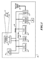
- Figure 1 illustrates an exemplary system formed in accordance with an embodiment of the present invention
- Figure 2 illustrates schematically a landing and approach zone to be surveyed according to an embodiment by the system of Figure 1 .
- An embodiment of the invention automatically surveys the terrain of a target landing zone for dimensions and locations of potential obstacles to landing therein. This survey information is corrected for inclination of the surveying system of the embodiment and oriented to true north.
- the resultant data is processed to produce a three-dimensional image or map of approaches to the landing zone, as well as the landing zone itself.
- This data and/or the 3-D image can be transmitted to the flight crews of one or more aircraft desiring to enter the landing zone. Using this data, the flight crews can plot a safe approach to the landing zone through a virtual image of the obstacles.
- the survey data can be used to calculate safe approach paths consisting of directions and altitudes, and the safe approaches and this information can be transmitted to the flight crews of one or more aircraft desiring to enter the landing zone.
- An embodiment may be mounted to, or otherwise carried by, a platform, such as a stationary platform or a mobile platform, such as a manned aircraft, an unmanned aerial vehicle, or a land-based vehicle.
- FIG. 1 illustrates a system 10 according to an embodiment, and in which an embodiment of the invention may be implemented.
- the system 10 illustrated in FIG. 1 typically includes at least one component, such as data reduction computer 12, including at least some form of computer readable media, which may be associated with one or more processors and/or memory devices.
- Computer readable media can be any available media that can be accessed by one or more components of such operating environment.
- Computer readable media may comprise computer storage media and communication media.
- Computer storage media includes volatile and nonvolatile, removable and non-removable media implemented in any method or technology for storage of information such as computer readable instructions, data structures, program modules or other data.
- Computer storage media includes, but is not limited to, RAM, ROM, EEPROM, flash memory or other memory technology, CD-ROM, digital versatile disks (DVD) or other optical storage, magnetic cassettes, magnetic tape, magnetic disk storage or other magnetic storage devices, or any other medium which can be used to store the desired information and which can be accessed by one or more components of such operating environment.
- Communication media typically embodies computer readable instructions, data structures, program modules or other data in a modulated data signal such as a carrier wave or other transport mechanism and includes any information delivery media.
- modulated data signal means a signal that has one or more of its characteristics set or changed in such a manner as to encode information in the signal.
- communication media includes wired media such as a wired network or direct-wired connection, and wireless media such as acoustic, RF, infrared and other wireless media. Combinations of the any of the above should also be included within the scope of computer readable media.
- program modules include routines, programs, objects, components, data structures, etc. that perform particular tasks or implement particular abstract data types.
- functionality of the program modules may be combined or distributed as desired in various embodiments.
- the system 10 (generally defined in FIG. 1 by a dashed border) includes a processor, such as a data reduction computer 12, a LIDAR unit 14, a GPS receiver 16, a tilt sensor, such as a two-axis inclinometer 18, a magnetic-field sensor, such as a three-axis magnetometer 20, a radio data link assembly 22, a data link antenna 24, and a power supply 26 that may provide power to one or more of the system components via a power bus 28.
- the system 10 may further include a data bus 30 configured to enable data transfer among the system components.
- the system 10 is brought into a proximity of a desired landing zone 34 ( FIG. 2 ) of predetermined size, the proximity location being sufficient to enable the LIDAR unit 14 to scan the landing zone and a vicinity ( i.e ., approach zone 36, as shown in FIG. 2 ) thereof of predetermined size.
- a survey planner having access to the system 10 may, using the computer 12, select or otherwise input a center reference point coordinate in an approximate center of the predetermined landing zone 34 and approach zone 36. Alternatively, the survey planner may select or otherwise input a set of coordinates defining the landing zone 34 and/or approach zone 36.
- the rotating LIDAR unit 14 is then programmed, or is otherwise configured, to automatically scan the terrain of the landing zone 34 and approach zone 36 to survey one or more obstacles 32 (e . g ., trees, rock formations, buildings, etc .) present therein. More specifically, the LIDAR unit 14 may determine the locations/coordinates and one or more dimensions (e.g ., height and/or area) of a predetermined threshold dimension (e.g ., minimum height and/or area of a specified measurement-unit quantity) of the obstacles 32. The LIDAR unit 14 may be moved or transported to other locations in the landing zone if necessary to gain a complete picture of the landing zone.
- a predetermined threshold dimension e.g ., minimum height and/or area of a specified measurement-unit quantity
- the inclinometer 18 is configured to measure a tilt angle of the LIDAR unit 14 with respect to a reference, such as gravity. This tilt-measurement information may then used by the computer 12 to correct the measured obstacle dimension and location.
- the GPS receiver 16 is configured to provide the geolocation of the landing zone 34.
- the magnetometer 20 is configured to provide field data characterizing the terrestrial magnetic field associated with the location of the system 10.
- the magnetometer 20 and inclinometer 18 combine to provide the functionality of a three-axis compass that indicates to the computer 12 the direction of magnetic north, regardless of the tilt angle of the magnetometer. Alternatively, the direction of magnetic north may be determined using solely the field data provided by the magnetometer 20.
- the system 10 may further include a memory device 50 operable to store data retrievable by the computer 12.
- the memory device 50 may be configured to store a look-up table of magnetic-field-deviation data associated with the GPS position of the zones 34, 36.
- the field-deviation data may be stored in a location external to the system 10 and retrievable by the computer 12.
- the computer 12 may use this field-deviation data to correct the magnetometer 20 measurement of north relative to true north. Consequently, the orientation of the survey data collected by the LIDAR unit 14 can be oriented relative to true north without having to physically rotate or otherwise reorient the system 10 to align with true north.
- the comprehensively corrected data can be processed by the computer 12 to produce a three-dimensional obstacle map referenced to the GPS position of the zones 34, 36.
- a map may depict a virtual rendering of the location and orientation of the detected obstacles 32, as well as numerical data characterizing the coordinates and dimensions of the obstacles.
- the map may be produced in a format allowing a heads-up or other display, in conjunction with onboard aircraft avionics, to provide a full-motion 3-D virtual image of obstacles 32 present in the approach and landing zones 34, 36 and corresponding to the aircraft's movement therethrough.
- the radio link 22 and antenna 24 can be used to transmit the corrected data and or data representing the 3-D GPS-referenced map to the flight crews of selected aircraft desiring to approach and land in landing zone 34, or to a centralized collection point for distribution to pilots flying to the landing zone.
- the survey and/or map data may allow approaching aircraft to plot or otherwise discern a target landing area 38 within the landing zone 34, as well as one or more navigable approach routes 40 enabling such aircraft to safely land in the target area.
Landscapes
- Engineering & Computer Science (AREA)
- Physics & Mathematics (AREA)
- Radar, Positioning & Navigation (AREA)
- Remote Sensing (AREA)
- General Physics & Mathematics (AREA)
- Computer Networks & Wireless Communication (AREA)
- Electromagnetism (AREA)
- Aviation & Aerospace Engineering (AREA)
- Navigation (AREA)
- Position Fixing By Use Of Radio Waves (AREA)
- Measuring Magnetic Variables (AREA)
Applications Claiming Priority (1)
| Application Number | Priority Date | Filing Date | Title |
|---|---|---|---|
| US12/368,142 US20100204919A1 (en) | 2009-02-09 | 2009-02-09 | Automated landing zone site surveying |
Publications (2)
| Publication Number | Publication Date |
|---|---|
| EP2224263A1 true EP2224263A1 (de) | 2010-09-01 |
| EP2224263B1 EP2224263B1 (de) | 2012-01-04 |
Family
ID=42097465
Family Applications (1)
| Application Number | Title | Priority Date | Filing Date |
|---|---|---|---|
| EP10152031A Active EP2224263B1 (de) | 2009-02-09 | 2010-01-28 | Automatisierte Landeplatzvermessung |
Country Status (3)
| Country | Link |
|---|---|
| US (1) | US20100204919A1 (de) |
| EP (1) | EP2224263B1 (de) |
| AT (1) | ATE540324T1 (de) |
Cited By (2)
| Publication number | Priority date | Publication date | Assignee | Title |
|---|---|---|---|---|
| WO2013162839A1 (en) * | 2012-04-24 | 2013-10-31 | Exelis Inc. | Point cloud visualization of acceptable helicopter landing zones based on 4d lidar |
| US11587449B2 (en) | 2020-02-21 | 2023-02-21 | Honeywell International Inc. | Systems and methods for guiding a vertical takeoff and landing vehicle to an emergency landing zone |
Families Citing this family (9)
| Publication number | Priority date | Publication date | Assignee | Title |
|---|---|---|---|---|
| EP2418510B1 (de) * | 2010-07-30 | 2014-01-29 | EADS Deutschland GmbH | Verfahren zur Beurteilung einer Bodenfläche auf deren Eignung als Landezone oder Rollfläche für Luftfahrzeuge |
| US8285305B2 (en) | 2010-09-13 | 2012-10-09 | Honeywell International Inc. | Notifying a user of an event |
| US8457179B2 (en) | 2010-09-13 | 2013-06-04 | Honeywell International Inc. | Devices, methods, and systems for building monitoring |
| US8521343B2 (en) * | 2011-08-02 | 2013-08-27 | The Boeing Company | Method and system to autonomously direct aircraft to emergency-contingency landing sites using on-board sensors |
| WO2015200086A1 (en) * | 2014-06-23 | 2015-12-30 | Sikorsky Aircraft Corporation | Cooperative safe landing area determination |
| US9617011B2 (en) | 2014-06-24 | 2017-04-11 | Sikorsky Aircraft Corporation | Probabilistic safe landing area determination |
| US9892646B2 (en) | 2014-07-22 | 2018-02-13 | Sikorsky Aircraft Corporation | Context-aware landing zone classification |
| WO2016109000A2 (en) | 2014-10-20 | 2016-07-07 | Sikorsky Aircraft Corporation | Optimal safe landing area determination |
| US11231706B1 (en) * | 2016-09-23 | 2022-01-25 | Amazon Technologies, Inc. | Landing and delivery robot |
Citations (1)
| Publication number | Priority date | Publication date | Assignee | Title |
|---|---|---|---|---|
| US20070075893A1 (en) | 2005-05-19 | 2007-04-05 | Francois Xavier Filias | System for estimating the speed of an aircraft, and an application thereof to detecting obstacles |
Family Cites Families (2)
| Publication number | Priority date | Publication date | Assignee | Title |
|---|---|---|---|---|
| US5878356A (en) * | 1995-06-14 | 1999-03-02 | Agrometrics, Inc. | Aircraft based infrared mapping system for earth based resources |
| US7737965B2 (en) * | 2005-06-09 | 2010-06-15 | Honeywell International Inc. | Handheld synthetic vision device |
-
2009
- 2009-02-09 US US12/368,142 patent/US20100204919A1/en not_active Abandoned
-
2010
- 2010-01-28 EP EP10152031A patent/EP2224263B1/de active Active
- 2010-01-28 AT AT10152031T patent/ATE540324T1/de active
Patent Citations (1)
| Publication number | Priority date | Publication date | Assignee | Title |
|---|---|---|---|---|
| US20070075893A1 (en) | 2005-05-19 | 2007-04-05 | Francois Xavier Filias | System for estimating the speed of an aircraft, and an application thereof to detecting obstacles |
Cited By (4)
| Publication number | Priority date | Publication date | Assignee | Title |
|---|---|---|---|---|
| WO2013162839A1 (en) * | 2012-04-24 | 2013-10-31 | Exelis Inc. | Point cloud visualization of acceptable helicopter landing zones based on 4d lidar |
| US8600589B2 (en) | 2012-04-24 | 2013-12-03 | Exelis, Inc. | Point cloud visualization of acceptable helicopter landing zones based on 4D LIDAR |
| JP2015522458A (ja) * | 2012-04-24 | 2015-08-06 | エクセリス インコーポレイテッド | 4dlidarに基づく許容ヘリコプター着陸地点のポイントクラウド可視化 |
| US11587449B2 (en) | 2020-02-21 | 2023-02-21 | Honeywell International Inc. | Systems and methods for guiding a vertical takeoff and landing vehicle to an emergency landing zone |
Also Published As
| Publication number | Publication date |
|---|---|
| EP2224263B1 (de) | 2012-01-04 |
| ATE540324T1 (de) | 2012-01-15 |
| US20100204919A1 (en) | 2010-08-12 |
Similar Documents
| Publication | Publication Date | Title |
|---|---|---|
| EP2224263B1 (de) | Automatisierte Landeplatzvermessung | |
| US12007761B2 (en) | Unmanned aerial vehicle inspection system | |
| US12428147B2 (en) | Unmanned aerial vehicle inspection system | |
| US11032527B2 (en) | Unmanned aerial vehicle surface projection | |
| US11017679B2 (en) | Unmanned aerial vehicle visual point cloud navigation | |
| Rinaudo et al. | Archaeological site monitoring: UAV photogrammetry can be an answer | |
| US10996055B2 (en) | Integrated aerial photogrammetry surveys | |
| US6748325B1 (en) | Navigation system | |
| US9513635B1 (en) | Unmanned aerial vehicle inspection system | |
| CN109405836B (zh) | 用于确定无人驾驶汽车的可驾驶导航路径的方法和系统 | |
| CN108253969B (zh) | 一种无人机飞行视距链路覆盖范围的计算方法 | |
| JP6290735B2 (ja) | 測量方法 | |
| US11029707B2 (en) | Moving object, moving object control method, moving object control system, and moving object control program | |
| CN109661694B (zh) | 控制无人飞行器飞行的方法和设备、限飞区生成方法和设备 | |
| JP6138326B1 (ja) | 移動体、移動体の制御方法、移動体を制御するプログラム、制御システム、及び情報処理装置 | |
| US20200064135A1 (en) | Method and apparatus for controlling unmanned aerial vehicle | |
| Moore et al. | UAV Inspection of Electrical Transmission Infrastructure with Path Conformance Autonomy and Lidar-based Geofences NASA Report on UTM Reference Mission Flights at Southern Company Flights November 2016 | |
| CN112923932A (zh) | 基于多传感融合定位的高精地图生成方法 | |
| CN117516511B (zh) | 一种基于无人机的高速路地理信息导航勘测方法 | |
| KR102642117B1 (ko) | Uav의 3차원 비행경로 설정방법 | |
| US7907132B1 (en) | Egocentric display | |
| RU2583851C2 (ru) | Беспилотный мобильный комплекс | |
| EP4575695A2 (de) | Unbemanntes luftsteuerpunktschwarmsystem für präzisionsabbildung | |
| US20210141097A1 (en) | Guided mobile platform | |
| Henari | Implementation of Unmanned Aerial Vehicle for Cadastral Mapping |
Legal Events
| Date | Code | Title | Description |
|---|---|---|---|
| PUAI | Public reference made under article 153(3) epc to a published international application that has entered the european phase |
Free format text: ORIGINAL CODE: 0009012 |
|
| 17P | Request for examination filed |
Effective date: 20100128 |
|
| AK | Designated contracting states |
Kind code of ref document: A1 Designated state(s): AT BE BG CH CY CZ DE DK EE ES FI FR GB GR HR HU IE IS IT LI LT LU LV MC MK MT NL NO PL PT RO SE SI SK SM TR |
|
| GRAP | Despatch of communication of intention to grant a patent |
Free format text: ORIGINAL CODE: EPIDOSNIGR1 |
|
| GRAS | Grant fee paid |
Free format text: ORIGINAL CODE: EPIDOSNIGR3 |
|
| GRAA | (expected) grant |
Free format text: ORIGINAL CODE: 0009210 |
|
| AK | Designated contracting states |
Kind code of ref document: B1 Designated state(s): AT BE BG CH CY CZ DE DK EE ES FI FR GB GR HR HU IE IS IT LI LT LU LV MC MK MT NL NO PL PT RO SE SI SK SM TR |
|
| REG | Reference to a national code |
Ref country code: GB Ref legal event code: FG4D |
|
| REG | Reference to a national code |
Ref country code: CH Ref legal event code: EP |
|
| REG | Reference to a national code |
Ref country code: AT Ref legal event code: REF Ref document number: 540324 Country of ref document: AT Kind code of ref document: T Effective date: 20120115 |
|
| REG | Reference to a national code |
Ref country code: IE Ref legal event code: FG4D |
|
| REG | Reference to a national code |
Ref country code: DE Ref legal event code: R096 Ref document number: 602010000591 Country of ref document: DE Effective date: 20120308 |
|
| REG | Reference to a national code |
Ref country code: NL Ref legal event code: T3 |
|
| PG25 | Lapsed in a contracting state [announced via postgrant information from national office to epo] |
Ref country code: SI Free format text: LAPSE BECAUSE OF FAILURE TO SUBMIT A TRANSLATION OF THE DESCRIPTION OR TO PAY THE FEE WITHIN THE PRESCRIBED TIME-LIMIT Effective date: 20120104 |
|
| LTIE | Lt: invalidation of european patent or patent extension |
Effective date: 20120104 |
|
| PG25 | Lapsed in a contracting state [announced via postgrant information from national office to epo] |
Ref country code: IS Free format text: LAPSE BECAUSE OF FAILURE TO SUBMIT A TRANSLATION OF THE DESCRIPTION OR TO PAY THE FEE WITHIN THE PRESCRIBED TIME-LIMIT Effective date: 20120504 Ref country code: BE Free format text: LAPSE BECAUSE OF FAILURE TO SUBMIT A TRANSLATION OF THE DESCRIPTION OR TO PAY THE FEE WITHIN THE PRESCRIBED TIME-LIMIT Effective date: 20120104 Ref country code: HR Free format text: LAPSE BECAUSE OF FAILURE TO SUBMIT A TRANSLATION OF THE DESCRIPTION OR TO PAY THE FEE WITHIN THE PRESCRIBED TIME-LIMIT Effective date: 20120104 Ref country code: NO Free format text: LAPSE BECAUSE OF FAILURE TO SUBMIT A TRANSLATION OF THE DESCRIPTION OR TO PAY THE FEE WITHIN THE PRESCRIBED TIME-LIMIT Effective date: 20120404 Ref country code: BG Free format text: LAPSE BECAUSE OF FAILURE TO SUBMIT A TRANSLATION OF THE DESCRIPTION OR TO PAY THE FEE WITHIN THE PRESCRIBED TIME-LIMIT Effective date: 20120404 Ref country code: LT Free format text: LAPSE BECAUSE OF FAILURE TO SUBMIT A TRANSLATION OF THE DESCRIPTION OR TO PAY THE FEE WITHIN THE PRESCRIBED TIME-LIMIT Effective date: 20120104 |
|
| PG25 | Lapsed in a contracting state [announced via postgrant information from national office to epo] |
Ref country code: LV Free format text: LAPSE BECAUSE OF FAILURE TO SUBMIT A TRANSLATION OF THE DESCRIPTION OR TO PAY THE FEE WITHIN THE PRESCRIBED TIME-LIMIT Effective date: 20120104 Ref country code: PL Free format text: LAPSE BECAUSE OF FAILURE TO SUBMIT A TRANSLATION OF THE DESCRIPTION OR TO PAY THE FEE WITHIN THE PRESCRIBED TIME-LIMIT Effective date: 20120104 Ref country code: PT Free format text: LAPSE BECAUSE OF FAILURE TO SUBMIT A TRANSLATION OF THE DESCRIPTION OR TO PAY THE FEE WITHIN THE PRESCRIBED TIME-LIMIT Effective date: 20120504 Ref country code: GR Free format text: LAPSE BECAUSE OF FAILURE TO SUBMIT A TRANSLATION OF THE DESCRIPTION OR TO PAY THE FEE WITHIN THE PRESCRIBED TIME-LIMIT Effective date: 20120405 Ref country code: MC Free format text: LAPSE BECAUSE OF NON-PAYMENT OF DUE FEES Effective date: 20120131 Ref country code: FI Free format text: LAPSE BECAUSE OF FAILURE TO SUBMIT A TRANSLATION OF THE DESCRIPTION OR TO PAY THE FEE WITHIN THE PRESCRIBED TIME-LIMIT Effective date: 20120104 |
|
| REG | Reference to a national code |
Ref country code: AT Ref legal event code: MK05 Ref document number: 540324 Country of ref document: AT Kind code of ref document: T Effective date: 20120104 |
|
| PG25 | Lapsed in a contracting state [announced via postgrant information from national office to epo] |
Ref country code: CY Free format text: LAPSE BECAUSE OF FAILURE TO SUBMIT A TRANSLATION OF THE DESCRIPTION OR TO PAY THE FEE WITHIN THE PRESCRIBED TIME-LIMIT Effective date: 20120104 |
|
| REG | Reference to a national code |
Ref country code: IE Ref legal event code: MM4A |
|
| PG25 | Lapsed in a contracting state [announced via postgrant information from national office to epo] |
Ref country code: CZ Free format text: LAPSE BECAUSE OF FAILURE TO SUBMIT A TRANSLATION OF THE DESCRIPTION OR TO PAY THE FEE WITHIN THE PRESCRIBED TIME-LIMIT Effective date: 20120104 Ref country code: RO Free format text: LAPSE BECAUSE OF FAILURE TO SUBMIT A TRANSLATION OF THE DESCRIPTION OR TO PAY THE FEE WITHIN THE PRESCRIBED TIME-LIMIT Effective date: 20120104 Ref country code: EE Free format text: LAPSE BECAUSE OF FAILURE TO SUBMIT A TRANSLATION OF THE DESCRIPTION OR TO PAY THE FEE WITHIN THE PRESCRIBED TIME-LIMIT Effective date: 20120104 Ref country code: DK Free format text: LAPSE BECAUSE OF FAILURE TO SUBMIT A TRANSLATION OF THE DESCRIPTION OR TO PAY THE FEE WITHIN THE PRESCRIBED TIME-LIMIT Effective date: 20120104 Ref country code: SE Free format text: LAPSE BECAUSE OF FAILURE TO SUBMIT A TRANSLATION OF THE DESCRIPTION OR TO PAY THE FEE WITHIN THE PRESCRIBED TIME-LIMIT Effective date: 20120104 |
|
| PLBE | No opposition filed within time limit |
Free format text: ORIGINAL CODE: 0009261 |
|
| STAA | Information on the status of an ep patent application or granted ep patent |
Free format text: STATUS: NO OPPOSITION FILED WITHIN TIME LIMIT |
|
| PG25 | Lapsed in a contracting state [announced via postgrant information from national office to epo] |
Ref country code: SK Free format text: LAPSE BECAUSE OF FAILURE TO SUBMIT A TRANSLATION OF THE DESCRIPTION OR TO PAY THE FEE WITHIN THE PRESCRIBED TIME-LIMIT Effective date: 20120104 |
|
| 26N | No opposition filed |
Effective date: 20121005 |
|
| PG25 | Lapsed in a contracting state [announced via postgrant information from national office to epo] |
Ref country code: AT Free format text: LAPSE BECAUSE OF FAILURE TO SUBMIT A TRANSLATION OF THE DESCRIPTION OR TO PAY THE FEE WITHIN THE PRESCRIBED TIME-LIMIT Effective date: 20120104 Ref country code: IE Free format text: LAPSE BECAUSE OF NON-PAYMENT OF DUE FEES Effective date: 20120128 |
|
| REG | Reference to a national code |
Ref country code: DE Ref legal event code: R097 Ref document number: 602010000591 Country of ref document: DE Effective date: 20121005 |
|
| PG25 | Lapsed in a contracting state [announced via postgrant information from national office to epo] |
Ref country code: MK Free format text: LAPSE BECAUSE OF FAILURE TO SUBMIT A TRANSLATION OF THE DESCRIPTION OR TO PAY THE FEE WITHIN THE PRESCRIBED TIME-LIMIT Effective date: 20120104 |
|
| PG25 | Lapsed in a contracting state [announced via postgrant information from national office to epo] |
Ref country code: ES Free format text: LAPSE BECAUSE OF FAILURE TO SUBMIT A TRANSLATION OF THE DESCRIPTION OR TO PAY THE FEE WITHIN THE PRESCRIBED TIME-LIMIT Effective date: 20120415 |
|
| PG25 | Lapsed in a contracting state [announced via postgrant information from national office to epo] |
Ref country code: MT Free format text: LAPSE BECAUSE OF FAILURE TO SUBMIT A TRANSLATION OF THE DESCRIPTION OR TO PAY THE FEE WITHIN THE PRESCRIBED TIME-LIMIT Effective date: 20120104 |
|
| PG25 | Lapsed in a contracting state [announced via postgrant information from national office to epo] |
Ref country code: TR Free format text: LAPSE BECAUSE OF FAILURE TO SUBMIT A TRANSLATION OF THE DESCRIPTION OR TO PAY THE FEE WITHIN THE PRESCRIBED TIME-LIMIT Effective date: 20120104 |
|
| PG25 | Lapsed in a contracting state [announced via postgrant information from national office to epo] |
Ref country code: SM Free format text: LAPSE BECAUSE OF FAILURE TO SUBMIT A TRANSLATION OF THE DESCRIPTION OR TO PAY THE FEE WITHIN THE PRESCRIBED TIME-LIMIT Effective date: 20120104 Ref country code: LU Free format text: LAPSE BECAUSE OF NON-PAYMENT OF DUE FEES Effective date: 20120128 |
|
| PG25 | Lapsed in a contracting state [announced via postgrant information from national office to epo] |
Ref country code: HU Free format text: LAPSE BECAUSE OF FAILURE TO SUBMIT A TRANSLATION OF THE DESCRIPTION OR TO PAY THE FEE WITHIN THE PRESCRIBED TIME-LIMIT Effective date: 20100128 |
|
| REG | Reference to a national code |
Ref country code: CH Ref legal event code: PL |
|
| PG25 | Lapsed in a contracting state [announced via postgrant information from national office to epo] |
Ref country code: LI Free format text: LAPSE BECAUSE OF NON-PAYMENT OF DUE FEES Effective date: 20140131 Ref country code: CH Free format text: LAPSE BECAUSE OF NON-PAYMENT OF DUE FEES Effective date: 20140131 |
|
| REG | Reference to a national code |
Ref country code: FR Ref legal event code: PLFP Year of fee payment: 7 |
|
| REG | Reference to a national code |
Ref country code: FR Ref legal event code: PLFP Year of fee payment: 8 |
|
| REG | Reference to a national code |
Ref country code: FR Ref legal event code: PLFP Year of fee payment: 9 |
|
| PGFP | Annual fee paid to national office [announced via postgrant information from national office to epo] |
Ref country code: GB Payment date: 20220118 Year of fee payment: 13 |
|
| PGFP | Annual fee paid to national office [announced via postgrant information from national office to epo] |
Ref country code: NL Payment date: 20220126 Year of fee payment: 13 |
|
| P01 | Opt-out of the competence of the unified patent court (upc) registered |
Effective date: 20230525 |
|
| REG | Reference to a national code |
Ref country code: NL Ref legal event code: MM Effective date: 20230201 |
|
| GBPC | Gb: european patent ceased through non-payment of renewal fee |
Effective date: 20230128 |
|
| PG25 | Lapsed in a contracting state [announced via postgrant information from national office to epo] |
Ref country code: NL Free format text: LAPSE BECAUSE OF NON-PAYMENT OF DUE FEES Effective date: 20230201 Ref country code: GB Free format text: LAPSE BECAUSE OF NON-PAYMENT OF DUE FEES Effective date: 20230128 |
|
| PGFP | Annual fee paid to national office [announced via postgrant information from national office to epo] |
Ref country code: DE Payment date: 20260127 Year of fee payment: 17 |
|
| PGFP | Annual fee paid to national office [announced via postgrant information from national office to epo] |
Ref country code: IT Payment date: 20260123 Year of fee payment: 17 |
|
| PGFP | Annual fee paid to national office [announced via postgrant information from national office to epo] |
Ref country code: FR Payment date: 20260127 Year of fee payment: 17 |