EP2246714A2 - Methode zur Modelldarstellung eines heterogenen unterirdischen Milieus auf der Basis einer Mehrpunktstatistik - Google Patents
Methode zur Modelldarstellung eines heterogenen unterirdischen Milieus auf der Basis einer Mehrpunktstatistik Download PDFInfo
- Publication number
- EP2246714A2 EP2246714A2 EP10290146A EP10290146A EP2246714A2 EP 2246714 A2 EP2246714 A2 EP 2246714A2 EP 10290146 A EP10290146 A EP 10290146A EP 10290146 A EP10290146 A EP 10290146A EP 2246714 A2 EP2246714 A2 EP 2246714A2
- Authority
- EP
- European Patent Office
- Prior art keywords
- pixel
- image
- physical property
- neighborhood
- auxiliary
- Prior art date
- Legal status (The legal status is an assumption and is not a legal conclusion. Google has not performed a legal analysis and makes no representation as to the accuracy of the status listed.)
- Withdrawn
Links
- 238000000034 method Methods 0.000 title claims abstract description 59
- 230000000704 physical effect Effects 0.000 claims abstract description 75
- 238000009826 distribution Methods 0.000 claims abstract description 31
- 238000012549 training Methods 0.000 claims description 15
- 238000005259 measurement Methods 0.000 claims description 10
- 230000001143 conditioned effect Effects 0.000 claims description 9
- 238000005293 physical law Methods 0.000 abstract 1
- 238000004088 simulation Methods 0.000 description 32
- 238000010276 construction Methods 0.000 description 16
- 230000008569 process Effects 0.000 description 9
- 239000003208 petroleum Substances 0.000 description 6
- 230000006399 behavior Effects 0.000 description 5
- 230000006870 function Effects 0.000 description 4
- 230000008901 benefit Effects 0.000 description 3
- 238000004422 calculation algorithm Methods 0.000 description 3
- 238000004364 calculation method Methods 0.000 description 3
- 210000004027 cell Anatomy 0.000 description 3
- 229930195733 hydrocarbon Natural products 0.000 description 3
- 150000002430 hydrocarbons Chemical class 0.000 description 3
- 235000019738 Limestone Nutrition 0.000 description 2
- 241001080024 Telles Species 0.000 description 2
- 238000013459 approach Methods 0.000 description 2
- 238000012550 audit Methods 0.000 description 2
- 239000004927 clay Substances 0.000 description 2
- 230000008021 deposition Effects 0.000 description 2
- 239000012530 fluid Substances 0.000 description 2
- 230000002068 genetic effect Effects 0.000 description 2
- 239000006028 limestone Substances 0.000 description 2
- 238000004519 manufacturing process Methods 0.000 description 2
- 238000011160 research Methods 0.000 description 2
- -1 sandstone Substances 0.000 description 2
- 240000008042 Zea mays Species 0.000 description 1
- 238000007635 classification algorithm Methods 0.000 description 1
- 230000001427 coherent effect Effects 0.000 description 1
- 239000000470 constituent Substances 0.000 description 1
- 230000001419 dependent effect Effects 0.000 description 1
- 238000005553 drilling Methods 0.000 description 1
- 230000007613 environmental effect Effects 0.000 description 1
- 230000003628 erosive effect Effects 0.000 description 1
- 238000013213 extrapolation Methods 0.000 description 1
- 238000003384 imaging method Methods 0.000 description 1
- 238000002347 injection Methods 0.000 description 1
- 239000007924 injection Substances 0.000 description 1
- 230000010354 integration Effects 0.000 description 1
- 230000004807 localization Effects 0.000 description 1
- 230000000116 mitigating effect Effects 0.000 description 1
- 230000008520 organization Effects 0.000 description 1
- 238000004806 packaging method and process Methods 0.000 description 1
- 230000035699 permeability Effects 0.000 description 1
- 238000011084 recovery Methods 0.000 description 1
- 230000003252 repetitive effect Effects 0.000 description 1
- 230000000717 retained effect Effects 0.000 description 1
- 238000004062 sedimentation Methods 0.000 description 1
Images


Classifications
-
- G—PHYSICS
- G01—MEASURING; TESTING
- G01V—GEOPHYSICS; GRAVITATIONAL MEASUREMENTS; DETECTING MASSES OR OBJECTS; TAGS
- G01V11/00—Prospecting or detecting by methods combining techniques covered by two or more of main groups G01V1/00 - G01V9/00
-
- G—PHYSICS
- G01—MEASURING; TESTING
- G01V—GEOPHYSICS; GRAVITATIONAL MEASUREMENTS; DETECTING MASSES OR OBJECTS; TAGS
- G01V1/00—Seismology; Seismic or acoustic prospecting or detecting
- G01V1/28—Processing seismic data, e.g. for interpretation or for event detection
- G01V1/30—Analysis
-
- G—PHYSICS
- G01—MEASURING; TESTING
- G01V—GEOPHYSICS; GRAVITATIONAL MEASUREMENTS; DETECTING MASSES OR OBJECTS; TAGS
- G01V2210/00—Details of seismic processing or analysis
- G01V2210/60—Analysis
- G01V2210/66—Subsurface modeling
- G01V2210/665—Subsurface modeling using geostatistical modeling
Definitions
- the present invention relates to the field of the exploration and exploitation of oil deposits, and more particularly the field of imaging of oil deposits.
- geological models in the broad sense. These well-known models, widely used in the oil industry, make it possible to determine numerous technical parameters relating to the research, the study or the exploitation of a reservoir, of hydrocarbons for example. Indeed, this geological model is representative of the structure of the reservoir as well as its behavior. It is thus possible, for example, to determine which zones are most likely to contain hydrocarbons, the zones in which it may be interesting / necessary to drill an injection well to improve the recovery of hydrocarbons, the type of tools used. to use, the properties of the fluids used and recovered .... These interpretations of geological models in terms of "technical operating parameters" are well known to specialists, although new methods are regularly developed. It is therefore crucial, in the oil field, to build as accurate a model as possible. To do this, the integration of all available data is essential.
- Oil reservoirs are generally very heterogeneous and fractured environments.
- the modeling of a reservoir ie the construction of a geological model representative of the reservoir, requires the use of so-called “probabilistic” construction methods because of the limitation of the available information (number of restricted well, ).
- geological models constructed from these probabilistic processes are called “stochastic models”.
- the construction of a stochastic reservoir model must first depend on the environment of the geological repository, which allows to represent the major heterogeneities that control the flow of fluids. Then, a model must be constrained by quantitative data such as core measurements, logging, seismic, which further increases the reliability of the model for production forecasting.
- a geological model is a model of the subsoil, representative of both its structure and its behavior.
- this type of model is represented on a computer, and one speaks then of numerical model.
- 2D we speak of map.
- a map corresponds to an image, made up of pixels, each of the pixels containing information relating to the behavior of the subsoil studied (a petroleum reservoir for example). These pixels correspond to a precise geographical position, and are marked by coordinates.
- When assigning values to a pixel for example by simulation, we speak of a simulation point.
- the representative image (the map or the model) is generated on any support (paper, computer screen, ).
- geological concept refers to the physical rules of sedimentation in each type of depositional environment.
- the heterogeneity is non-stationary at the scale of the oil field studied. This non-stationary variability is often accessible via information, eg from seismic, which is low resolution but covers the whole field.
- the method according to the invention is an alternative method making it possible to construct an image representative of a petroleum deposit, based on data measured at the wells and / or on the whole of the deposit studied.
- the method makes it possible to construct an image representing the distribution of a categorical physical property, such as lithology or fracturing of the subsoil, taking into account the geological concepts, the non-stationary character of the heterogeneity at the scale of the deposit. oil tanker studied, and by integrating all available data, in the form of continuous or non-continuous space constraints, quantitative and / or qualitative.
- the histograms can be determined by simultaneously scanning the training images using the neighborhood.
- an auxiliary physical property can be compatible with an empirical histogram: if this property is between the minimum and the maximum of the auxiliary values of this histogram; or, if this histogram admits a non-zero probability for the auxiliary physical property.
- the categorical physical property can be chosen from one of the following properties: lithology, fracturing state, presence of channels.
- the auxiliary physical properties can be chosen from among the following properties: lithological proportions, fracturing density, seismic attributes.
- the present invention relates to a method for constructing an image, constituting a geological model representative of the structure and behavior of a subterranean zone such as a petroleum reservoir or an aquifer, making it possible to determine technical parameters relating to the search, the study or exploitation of the area.
- An image constitutes a set of pixels, and each pixel is associated with a geographical position.
- the subsoil is a heterogeneous porous medium that can be characterized by different types of properties: categorical physical properties (lithologies, fracturing state, %), continuous physical properties (porosity, permeability, %), indirect physical properties (eg from seismic surveys).
- the method according to the invention makes it possible to generate an image representative of categorical physical properties. For example, lithologies (limestone, sandstone, clay, etc.) or the state of fracturing.
- the construction of a representative image of a categorical physical property includes associating with each pixel of the image a value of this categorical physical property.
- This categorical physical property is called the main property ( PP ) in the following description.
- a first learning image is constructed by assigning to each pixel of this first learning image a categorical physical property value.
- the categorical physical property can be chosen from one of the following properties: lithology, fracturing state, presence of channels.
- This type of method makes it possible to represent the major heterogeneities from the sole knowledge of the geological repository environment.
- This first learning image is therefore constructed from a priori information, and constitutes a representation of the geological repository environment. Each pixel of this image is associated with a value of the main property PP .
- This image defines a geometric structure of the main property ( PP ). At this point, it is not the actual geometric structure of the main property ( PP ). It is only a possible representation.
- the first training image represents a geometric structure of the main property ( PP ) for a given deposit environment. From this first image, which constitutes an environment, an image is created representing the distribution of each possible auxiliary property ( PA ) taking into account the environment. To do this, each pixel of these images is assigned an auxiliary physical property value determined from the first training image.
- At least two auxiliary physical properties are selected, whose spatial distributions are representative of the spatial distribution of the categorical physical property ( PP ).
- these properties can be chosen from the following properties: lithological proportions, fracturing density, seismic attributes.
- geophysical modeling techniques such as ray tracing, which are well known to those skilled in the art, can be used to determine seismic amplitudes that can be measured during a seismic survey in a geological medium defined by the first one. learning image.
- Each auxiliary training image thus represents a distribution of an auxiliary property ( PA ), in agreement with the geological environment defined by the first image. It is obtained by digital simulation techniques known per se (resolution of a system of physical equations) using the first image as environment.
- the first represents the deposition environment, it is representative of a geometrical structure of the categorical physical property ( PP ), and each other images represent a distribution of an auxiliary property ( PA ), respecting the environment of the first image.
- step 4 we capture the geometric structure of the main property, which we associate with auxiliary data in order to recreate the structure from the auxiliary data when we do not know the value of the main property in each pixel (step 4).
- step 4 we compute statistics that allow us to extract the geometric structures of the main property and their distribution in the simulation field, that is to say the geographical space for which one wishes to build a model of the subsoil (oil reservoir for example).
- This object consists of a set of pixels: a central pixel and L ordered neighboring pixels.
- This exploration window may for example correspond to a rectangle.
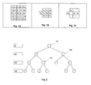
- the Figure 1A illustrates such an exploration window whose central pixel is represented by u c , and the neighboring pixels by u 1 , u 2 , etc.
- the window of exploration (template) is characterized by its shape and its number of pixels ( L +1). This is determined by the size of the geometric structures of interest. These structures may for example be faults, channels, etc.
- neighborhood states At each state of a complete neighborhood of size between 0 and L , we compute the empirical histogram of the values of the principal property in the center of the neighborhood and that of the values of each auxiliary property in the center of the neighborhood. The values taken by all the pixels of the neighborhood are called neighborhood states.
- the tree can be completely constructed. That is, all histograms are determined for all neighborhoods from 0 pixels (center pixel) to L pixels (size of the exploration window). At each node of the tree is associated a probability law (histogram) of the main physical property PP to the central pixel of the neighborhood conditioned by the state of the neighborhood and a probability law (histogram) of each auxiliary physical property PA conditioned by the same state.
- each pixel of these images is assigned an auxiliary physical property value obtained from measurements made in the porous heterogeneous medium.
- a seismic survey can be used to obtain data on the whole area studied (ie the area represented by the images). In this way, an image is obtained, each pixel of which is indicated by a seismic amplitude value. Any other seismic attribute can of course be used.
- PC data can be acquired at the level of exploration or production wells. These logging data, once interpreted, make it possible to determine the different lithologies encountered during well drilling. From these data, maps of lithological proportions can be constructed by extrapolation. PC data can also be real PP main property data (lithologies, fracturing, presence or absence of channels, ).
- This step consists of constructing an image, constituting a geological model representative of the structure and behavior of the underground zone (petroleum reservoir, aquifer), making it possible to determine technical parameters relating to the research, the study or the exploitation of the zoned.
- This image represents the distribution of the main property in the subterranean zone studied. It is no longer a question of any distribution, but of the distribution supposed to best represent reality. To do this, we use the statistics stored in the tree structure, possibly point data of main property (lithologies filled to the wells for example), and images representing the distribution of several auxiliary properties chosen in the previous steps (seismic amplitudes or lithological proportions for example).
- This image has the same structure (number and location of pixels) as the learning images.
- This neighborhood is composed of previously simulated pixels and possibly pixels where the value of the main property is measured ( PC ). These pixels are located in a domain of size less than or equal to that of the template, that is to say that all the pixels of the neighborhood belong to the pixels of the template. These pixels are consecutive ( u 1 , u 2 , etc.). They form a neighborhood of size s.
- the main property is randomly selected at the simulation pixel according to this law.
- the method according to the invention is particularly well suited to construct an image representative of the spatial organization of lithologies within a petroleum deposit. This is to obtain an image constituting a map, on which the location of the different lithologies is represented: limestone, sandstone, clay, ...
- the lithologies (F0, F1 and F2) are considered as the main property (PP).
- PP main property
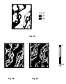
- the figure 3A shows a simulation realization for three lithologies (F0, F1 and F2), on a cartesian grid of 79 x 99 meshes (a mesh having dimension 100 mx 100 m). This image is used as a learning image of the main property.
- a concentric 150-point exploration window is defined.
- the figure 3C illustrates a proportion map of the "real" F1 lithology, that is to say that one wishes to respect. This is one of three maps (one for each lithology) that constrains the construction of the desired image.
- FIGS. 5A to 5D Six combinations are possible, but as some give similar results, only four different orders are presented in the simulation results.
- FIGS. 5A to 5D The choice of the optimal order is dependent on the geological knowledge of the deposition environment. In the present case (meandriform channels), the most realistic order corresponds to the order F1>F2> F0 ( Figure 5B ), the lithologies of channels being erosive compared to other lithologies.
- the method according to the invention is applied ( figure 4 ). A better reproduction of the continuity of the geometric structures of the learning image is observed. Moreover, for all the realizations carried out, only the multi lithologies simulations make it possible to reproduce in a conformal way the lithological proportions of the learning image while honoring the auxiliary constraint.
Landscapes
- Physics & Mathematics (AREA)
- Life Sciences & Earth Sciences (AREA)
- Engineering & Computer Science (AREA)
- Remote Sensing (AREA)
- General Life Sciences & Earth Sciences (AREA)
- General Physics & Mathematics (AREA)
- Geophysics (AREA)
- Acoustics & Sound (AREA)
- Environmental & Geological Engineering (AREA)
- Geology (AREA)
- Image Processing (AREA)
- Image Analysis (AREA)
Applications Claiming Priority (1)
| Application Number | Priority Date | Filing Date | Title |
|---|---|---|---|
| FR0902071A FR2944905B1 (fr) | 2009-04-28 | 2009-04-28 | Methode pour modeliser un milieu heterogene souterrain a partir de statistique multipoint |
Publications (1)
| Publication Number | Publication Date |
|---|---|
| EP2246714A2 true EP2246714A2 (de) | 2010-11-03 |
Family
ID=41650151
Family Applications (1)
| Application Number | Title | Priority Date | Filing Date |
|---|---|---|---|
| EP10290146A Withdrawn EP2246714A2 (de) | 2009-04-28 | 2010-03-19 | Methode zur Modelldarstellung eines heterogenen unterirdischen Milieus auf der Basis einer Mehrpunktstatistik |
Country Status (4)
| Country | Link |
|---|---|
| US (1) | US8422745B2 (de) |
| EP (1) | EP2246714A2 (de) |
| CA (1) | CA2701524A1 (de) |
| FR (1) | FR2944905B1 (de) |
Cited By (1)
| Publication number | Priority date | Publication date | Assignee | Title |
|---|---|---|---|---|
| CN105089657A (zh) * | 2015-06-15 | 2015-11-25 | 中国石油天然气股份有限公司 | 缝洞型碳酸盐岩储层油气充注的物理模拟方法及实验装置 |
Families Citing this family (6)
| Publication number | Priority date | Publication date | Assignee | Title |
|---|---|---|---|---|
| EP2761340B1 (de) | 2011-09-30 | 2016-01-13 | Total SA | Verfahren zum extrahieren von indexbildern aus einem trainingsbild zur beschränkung der geostatistischen mehrpunktmodellierung eines untergrunds |
| US10519766B2 (en) | 2011-10-26 | 2019-12-31 | Conocophillips Company | Reservoir modelling with multiple point statistics from a non-stationary training image |
| US9116258B2 (en) * | 2012-04-03 | 2015-08-25 | Schlumberger Technology Corporation | Parallel multipoint geostatistics simulation |
| US9140821B2 (en) * | 2012-04-03 | 2015-09-22 | Schlumberger Technology Corporation | Ordered multipoint geostatistics simulation using non-symmetric search mask |
| CN105069776B (zh) * | 2015-07-13 | 2018-05-15 | 中国石油大学(北京) | 一种基于数据事件差异度选择训练图像的方法 |
| CN112147679B (zh) * | 2019-06-26 | 2024-04-16 | 中国石油化工股份有限公司 | 在模糊逻辑框架下基于弹性参数的岩性预测方法和装置 |
Citations (1)
| Publication number | Priority date | Publication date | Assignee | Title |
|---|---|---|---|---|
| FR2905181A1 (fr) | 2006-08-28 | 2008-02-29 | Inst Francais Du Petrole | Methode pour modeliser un milieu heterogene souterrain a partir des statistiques multipoints et des donnees auxiliaires. |
Family Cites Families (2)
| Publication number | Priority date | Publication date | Assignee | Title |
|---|---|---|---|---|
| US7516055B2 (en) * | 2004-08-20 | 2009-04-07 | Chevron U.S.A. Inc | Multiple-point statistics (MPS) simulation with enhanced computational efficiency |
| US7853045B2 (en) * | 2007-10-31 | 2010-12-14 | Saudi Arabian Oil Company | Geostatistical analysis and classification of core data |
-
2009
- 2009-04-28 FR FR0902071A patent/FR2944905B1/fr not_active Expired - Fee Related
-
2010
- 2010-03-19 EP EP10290146A patent/EP2246714A2/de not_active Withdrawn
- 2010-04-26 CA CA2701524A patent/CA2701524A1/fr not_active Abandoned
- 2010-04-27 US US12/767,852 patent/US8422745B2/en not_active Expired - Fee Related
Patent Citations (1)
| Publication number | Priority date | Publication date | Assignee | Title |
|---|---|---|---|---|
| FR2905181A1 (fr) | 2006-08-28 | 2008-02-29 | Inst Francais Du Petrole | Methode pour modeliser un milieu heterogene souterrain a partir des statistiques multipoints et des donnees auxiliaires. |
Non-Patent Citations (11)
Cited By (2)
| Publication number | Priority date | Publication date | Assignee | Title |
|---|---|---|---|---|
| CN105089657A (zh) * | 2015-06-15 | 2015-11-25 | 中国石油天然气股份有限公司 | 缝洞型碳酸盐岩储层油气充注的物理模拟方法及实验装置 |
| CN105089657B (zh) * | 2015-06-15 | 2018-05-04 | 中国石油天然气股份有限公司 | 缝洞型碳酸盐岩储层油气充注的物理模拟方法及实验装置 |
Also Published As
| Publication number | Publication date |
|---|---|
| FR2944905B1 (fr) | 2017-01-20 |
| CA2701524A1 (fr) | 2010-10-28 |
| US20100272324A1 (en) | 2010-10-28 |
| FR2944905A1 (fr) | 2010-10-29 |
| US8422745B2 (en) | 2013-04-16 |
Similar Documents
| Publication | Publication Date | Title |
|---|---|---|
| EP2846176B1 (de) | Verfahren zum Ausbeuten einer untertägigen Lagerstätte mit mindestens einem Aufschluss mittels Photogrammetrie | |
| EP3835835B1 (de) | Verfahren zur aktualisierung eines stratigraphischen modells eines sedimentbeckens auf der grundlage von messungen | |
| FR3039679A1 (fr) | Affectation de sequences sedimentaires | |
| EP3570074A1 (de) | Verfahren zur detektion von geologischen objekten auf einem bild | |
| CA2746900C (fr) | Procede d'exploitation d'un gisement petrolier a partir d'un modele de reservoir deforme graduellement au moyen de cosimulations | |
| FR2909775A1 (fr) | Methode de construction d'un modele geologique d'une formation du sous-sol contraint par des donnees sismiques | |
| FR3036518A1 (fr) | Inversion pour contrainte tectonique | |
| EP2246714A2 (de) | Methode zur Modelldarstellung eines heterogenen unterirdischen Milieus auf der Basis einer Mehrpunktstatistik | |
| WO2009034253A1 (fr) | Procede, programme et systeme informatique de mise a l'echelle de donnees de modele de reservoir d'hydrocarbure | |
| CA2820498A1 (fr) | Procede d'exploitation d'un reservoir geologique a partir d'un modele de reservoir cale au moyen d'un parametrage multi-echelles | |
| Zare et al. | Reservoir facies and porosity modeling using seismic data and well logs by geostatistical simulation in an oil field | |
| FR3055723A1 (fr) | Modelisation basee sur un point-vecteur des proprietes de reservoir de petrole pour un modele de simulation de reservoir sans grille | |
| EP3523680B1 (de) | Verfahren zur herstellung eines geologischen vektormodells | |
| CA2765115C (fr) | Procede pour mettre a jour un modele de reservoir en temps reel a partir de donnees dynamiques tout en conservant sa coherence avec les observations statiques | |
| CA2732474C (fr) | Methode de calage d'historique d'un modele geologique comportant un reseau de failles sub-sismiques | |
| Jung et al. | Carbonate geobodies: hierarchical classification and database–a new workflow for 3D reservoir modelling | |
| EP2873989B1 (de) | Verfahren zum Erstellen eines repräsentativen Rasters einer physikalischen Eigentumsstreuung einer unterirdischen Formation durch bedingte statistische Mehrpunktsimulation | |
| CA2968579A1 (fr) | Procede d'exploitation des hydrocarbures d'une formation souterraine, au moyen d'une mise a l'echelle optimisee | |
| FR2905181A1 (fr) | Methode pour modeliser un milieu heterogene souterrain a partir des statistiques multipoints et des donnees auxiliaires. | |
| Khanna et al. | Undulating stratigraphy of a carbonate inner ramp lagoon and associated architectural facies heterogeneity: An example from the Late Jurassic Hanifa Formation, Central Saudi Arabia | |
| Baville | Stratigraphic correlation uncertainty: On the impact of the sediment transport direction in computer-assisted multi-well correlation | |
| Cassel | Machine learning and the construction of a seismic attribute-seismic facies analysis data base | |
| Hasler et al. | Fine-scale forward modelling of a Devonian patch reef, Canning Basin, Western Australia |
Legal Events
| Date | Code | Title | Description |
|---|---|---|---|
| PUAI | Public reference made under article 153(3) epc to a published international application that has entered the european phase |
Free format text: ORIGINAL CODE: 0009012 |
|
| AK | Designated contracting states |
Kind code of ref document: A2 Designated state(s): AT BE BG CH CY CZ DE DK EE ES FI FR GB GR HR HU IE IS IT LI LT LU LV MC MK MT NL NO PL PT RO SE SI SK SM TR |
|
| AX | Request for extension of the european patent |
Extension state: AL BA ME RS |
|
| STAA | Information on the status of an ep patent application or granted ep patent |
Free format text: STATUS: THE APPLICATION IS DEEMED TO BE WITHDRAWN |
|
| 18D | Application deemed to be withdrawn |
Effective date: 20151001 |