EP2333745A1 - Informationssystem fur Reisende - Google Patents
Informationssystem fur Reisende Download PDFInfo
- Publication number
- EP2333745A1 EP2333745A1 EP09450229A EP09450229A EP2333745A1 EP 2333745 A1 EP2333745 A1 EP 2333745A1 EP 09450229 A EP09450229 A EP 09450229A EP 09450229 A EP09450229 A EP 09450229A EP 2333745 A1 EP2333745 A1 EP 2333745A1
- Authority
- EP
- European Patent Office
- Prior art keywords
- plan
- information system
- route
- sightseeing
- entered
- Prior art date
- Legal status (The legal status is an assumption and is not a legal conclusion. Google has not performed a legal analysis and makes no representation as to the accuracy of the status listed.)
- Withdrawn
Links
- 238000007689 inspection Methods 0.000 description 3
- 238000013500 data storage Methods 0.000 description 1
Images


Classifications
-
- G—PHYSICS
- G09—EDUCATION; CRYPTOGRAPHY; DISPLAY; ADVERTISING; SEALS
- G09B—EDUCATIONAL OR DEMONSTRATION APPLIANCES; APPLIANCES FOR TEACHING, OR COMMUNICATING WITH, THE BLIND, DEAF OR MUTE; MODELS; PLANETARIA; GLOBES; MAPS; DIAGRAMS
- G09B5/00—Electrically-operated educational appliances
- G09B5/06—Electrically-operated educational appliances with both visual and audible presentation of the material to be studied
-
- G—PHYSICS
- G09—EDUCATION; CRYPTOGRAPHY; DISPLAY; ADVERTISING; SEALS
- G09B—EDUCATIONAL OR DEMONSTRATION APPLIANCES; APPLIANCES FOR TEACHING, OR COMMUNICATING WITH, THE BLIND, DEAF OR MUTE; MODELS; PLANETARIA; GLOBES; MAPS; DIAGRAMS
- G09B29/00—Maps; Plans; Charts; Diagrams, e.g. route diagram
- G09B29/003—Maps
- G09B29/006—Representation of non-cartographic information on maps, e.g. population distribution, wind direction, radiation levels, air and sea routes
- G09B29/008—Touring maps or guides to public transport networks
Definitions
- the invention relates to an information system, in particular for travelers, with a map, a description of sights and a data carrier that has stored retrievable information about sights.
- the well-known guides are relatively cumbersome to handle and it is therefore the object of the present invention to improve such information systems or guides so that their handling is easier.
- the information system allows the user to easily make a city tour or museum tour: based on the city map or museum plan, he initially oriented roughly on the route to go, then he has for each section a detailed plan and a description with photos of each visit points ,
- a tour is even more facilitated by a part of the plan that only reflects the sightseeing route.
- the orientation is facilitated in a city tour, when the device is a navigation device, in particular GPS device, connected.
- the user can inform himself in a known manner at any time where he actually is.
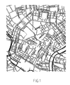
- the Fig. 1 shows the map of a known city, in this map the beginning 1 and the end 40 of a sightseeing route is entered.
- the Fig. 2 shows on a larger scale only the sightseeing route from 1 to 40 specified in the city map.
- the individual sightseeing points are, as entered in the city map, not marked.
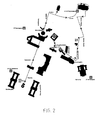
- FIG. 3 the first part 1 to 4 of the sightseeing route again.
- Fig. 4 figurative representations that give the user, apart from the acoustic description of the disk, a picture of the respective inspection point.
- the invention is not limited to use with city maps.
- the information system according to the invention can also be used e.g. used for museums: plan of the museum with beginning and end of the tour, individual sections, e.g. Halls of the sightseeing tour, description (also acoustically) and representation of individual inspection points.
Landscapes
- Engineering & Computer Science (AREA)
- Physics & Mathematics (AREA)
- Theoretical Computer Science (AREA)
- Business, Economics & Management (AREA)
- Educational Administration (AREA)
- Educational Technology (AREA)
- General Physics & Mathematics (AREA)
- Life Sciences & Earth Sciences (AREA)
- Ecology (AREA)
- Mathematical Physics (AREA)
- Management, Administration, Business Operations System, And Electronic Commerce (AREA)
- Navigation (AREA)
Abstract
Ein Informationssystem insbesondere für Reisende weist einen Plan, eine Beschreibung von Sehenswürdigkeiten und einen Datenträger, der abrufbare Informationen über Sehenswürdigkeiten gespeichert hat, auf. Im Plan ist Anfang (1) und Ende (40) einer Besichtigungsroute eingetragen, Abschnitte dieser Besichtigungsroute sind in gesonderten Plänen eingetragen und in diesen gesonderten Plänen sind einzelne Besichtigungspunkte eingetragen, zu denen Abbildungen, insbesondere Fotos, beigegeben sind.
Description
- Die Erfindung bezieht sich auf ein Informationssystem insbesondere für Reisende, mit einem Plan, einer Beschreibung von Sehenswürdigkeiten und einem Datenträger, der abrufbare Informationen über Sehenswürdigkeiten gespeichert hat.
- Bei bekannten Informationssystemen oder Reiseführern dieser Art sind die Sehenswürdigkeiten in Büchern der Reihe nach beschrieben, wobei ein Stadtplan die Orientierung erleichtert und eventuell über Ohrhörer in einem Datenträger gespeicherte Informationen wiedergegeben werden.
- Die bekannten Reiseführer sind relativ umständlich zu handhaben und es ist daher das Ziel vorliegender Erfindung solche Informationssysteme oder Reiseführer so zu verbessern, dass deren Handhabung einfacher ist.
- Erreicht wird dies bei einem Informationssystem der eingangs genannten Art dadurch, dass im Plan Anfang und Ende einer Besichtigungsroute eingetragen ist, dass Abschnitte dieser Besichtigungsroute in gesonderten Plänen eingetragen sind, und dass in diesen gesonderten Plänen einzelne Besichtigungspunkte eingetragen sind, zu denen Abbildungen, insbesondere Fotos, beigegeben sind.
- Das erfindungsgemäße Informationssystem ermöglicht es dem Benützer auf einfache Weise einen Stadtrundgang oder Museumsrundgang durchzuführen: anhand des Stadtplanes oder Museumsplanes orientiert er sich vorerst grob über die zu gehende Route, anschließend hat er zu jedem Teilstück einen genauen Plan und je eine Beschreibung mit Fotos der einzelnen Besichtigungspunkte.
- Ein Rundgang wird durch einen nur die Besichtigungsroute wiedergebenden Teil des Planes noch mehr erleichtert.
- Die Orientierung wird bei einem Stadtrundgang erleichtert, wenn an dem Datenträger ein Navigationsgerät, insbesondere GPS-Gerät, angeschlossen ist. Damit kann sich der Benützer in bekannter Weise jederzeit informieren wo er sich tatsächlich befindet.
- Nachstehend ist die Erfindung anhand der Zeichnungen, in denen ein Ausführungsbeispiel der Erfindung dargestellt ist, näher beschrieben, ohne auf dieses Ausführungsbeispiel beschränkt zu sein.
- Dabei zeigen:
- Fig. 1
- den Stadtplan eines erfindungsgemäßen Informationssystems mit eingetragenem Anfang und Ende einer Besichtigungsroute;
- Fig. 2
- einen vergrößerten Ausschnitt aus dem Stadtplan mit der gesamten Besichtigungsroute;
- Fig. 3
- einen Plan des ersten Abschnittes der vorgesehenen Besichtigungsroute mit einer fotografischen Darstellung des ersten Besichtigungspunktes der Route;
- Fig. 4
- Fotos der in
Fig. 3 angegebenen Besichtigungspunkte 2, 3 und 4. - Die
Fig. 1 zeigt den Stadtplan einer bekannten Stadt, wobei in diesem Stadtplan der Anfang 1 und das Ende 40 einer Besichtigungsroute eingetragen ist. - Die
Fig. 2 zeigt in größerem Maßstab nur die im Stadtplan angegebene Besichtigungsroute von 1 bis 40. Die einzelnen Besichtigungspunkte sind, so wie im Stadtplan eingetragen, jedoch nicht bezeichnet. - Schließlich gibt die
Fig. 3 den ersten Teil 1 bis 4 der Besichtigungsroute wieder. Zu den einzelnen Besichtigungspunkten 1 bis 4 sind, siehe auchFig. 4 , bildliche Darstellungen enthalten, die dem Benutzer außer der akustischen Beschreibung vom Datenträger, ein Bild des jeweiligen Besichtigungspunktes geben. - Diese bildlichen Darstellungen werden im Normalfall Fotos sein, um den Zeichnungsvorschriften zu genügen, wurden sie jedoch als Strichzeichnungen wiedergegeben.
- Die Erfindung ist nicht auf die Verwendung mit Stadtplänen beschränkt. Das erfindungsgemäße Informationssystem kann auch z.B. für Museen angewendet werden: Plan des Museums mit Anfang und Ende der Besichtigungstour, einzelne Abschnitte, z.B. Säle der Besichtigungstour, Beschreibung (auch akustisch) und Darstellung einzelner Besichtigungspunkte.
Claims (3)
- Informationssystem insbesondere für Reisende, mit einem Plan, einer Beschreibung von Sehenswürdigkeiten und einem Datenträger, der abrufbare Informationen über Sehenswürdigkeiten gespeichert hat, dadurch gekennzeichnet, dass im Plan Anfang (1) und Ende (40) einer Besichtigungsroute eingetragen ist, dass Abschnitte dieser Besichtigungsroute in gesonderten Plänen eingetragen sind, und dass in diesen gesonderten Plänen einzelne Besichtigungspunkte eingetragen sind, zu denen Abbildungen, insbesondere Fotos, beigegeben sind.
- Informationssystem nach Anspruch 1, gekennzeichnet durch einen nur die Besichtigungsroute wiedergebenden Teil des Planes.
- Informationssystem nach Anspruch 1 oder 2, dadurch gekennzeichnet, dass an den Datenträger ein Navigationsgerät, insbesondere GPS-Gerät, angeschlossen ist.
Priority Applications (1)
| Application Number | Priority Date | Filing Date | Title |
|---|---|---|---|
| EP09450229A EP2333745A1 (de) | 2009-12-01 | 2009-12-01 | Informationssystem fur Reisende |
Applications Claiming Priority (1)
| Application Number | Priority Date | Filing Date | Title |
|---|---|---|---|
| EP09450229A EP2333745A1 (de) | 2009-12-01 | 2009-12-01 | Informationssystem fur Reisende |
Publications (1)
| Publication Number | Publication Date |
|---|---|
| EP2333745A1 true EP2333745A1 (de) | 2011-06-15 |
Family
ID=42144941
Family Applications (1)
| Application Number | Title | Priority Date | Filing Date |
|---|---|---|---|
| EP09450229A Withdrawn EP2333745A1 (de) | 2009-12-01 | 2009-12-01 | Informationssystem fur Reisende |
Country Status (1)
| Country | Link |
|---|---|
| EP (1) | EP2333745A1 (de) |
Citations (3)
| Publication number | Priority date | Publication date | Assignee | Title |
|---|---|---|---|---|
| GB2444313A (en) * | 2006-10-13 | 2008-06-04 | Tom Brammar | Mobile device media downloading which re-uses stored media files |
| WO2008142510A2 (en) * | 2007-05-16 | 2008-11-27 | Teletron Euroricerche S.R.L. | Method and system for creating tourist paths adapted to be used by a portable navigation system |
| WO2009016661A1 (en) * | 2007-07-30 | 2009-02-05 | Administration's Center | A guide system for museums, trade fairs or exhibits in general and a related information process |
-
2009
- 2009-12-01 EP EP09450229A patent/EP2333745A1/de not_active Withdrawn
Patent Citations (3)
| Publication number | Priority date | Publication date | Assignee | Title |
|---|---|---|---|---|
| GB2444313A (en) * | 2006-10-13 | 2008-06-04 | Tom Brammar | Mobile device media downloading which re-uses stored media files |
| WO2008142510A2 (en) * | 2007-05-16 | 2008-11-27 | Teletron Euroricerche S.R.L. | Method and system for creating tourist paths adapted to be used by a portable navigation system |
| WO2009016661A1 (en) * | 2007-07-30 | 2009-02-05 | Administration's Center | A guide system for museums, trade fairs or exhibits in general and a related information process |
Similar Documents
| Publication | Publication Date | Title |
|---|---|---|
| Potts | Euclid's elements of geometry | |
| EP2333745A1 (de) | Informationssystem fur Reisende | |
| CALL | Records | |
| Berman | Grassroots coalitions in health and safety: The COSH groups | |
| Driggs | Fundamentalist attitudes toward the church: The sermons of Leroy S. Johnson | |
| BROWN | Bibliographical Essay | |
| Bachrach | Carolingian Military Operations: An Introduction to Technological Perspectives | |
| DeMartino et al. | The desert flowers always bloom following the monsoon: Activism, school boards, and COVID-19 | |
| Charles | Whistle | |
| Johnson | Walter Burley Griffin: An Expatriate Planner at Canberra | |
| Regelson et al. | The tragedy of Russian church 1917–1945 | |
| Elithorp Jr | A student recruitment program for geomatics | |
| Crawford | How I Became an Agricultural Economist | |
| Falconer | DIC TAPWREand U. y ath | |
| Hicks | My Ten Years on the Wisconsin Faculty | |
| Keeton | Honoring a Friend and Colleague | |
| DE8317220U1 (de) | Kartographische Darstellung auf elastischem Grund | |
| CommentsOn et al. | Will Leave For Ch'ina On State | |
| Blaauw | ESO's early history, 1953-1975. III. 26 May 1964: ESO chooses La Silla. | |
| Friend | A Book Revue: Studies are Not Every Thing: The Diary of a Freshman | |
| DE102019126207A1 (de) | Verfahren und System zur Reduzierung der Umweltbelastung durch eine Transportroute | |
| DE102020208858A1 (de) | Verfahren zum Bereitstellen eines elektronischen Vorschlags für ein Event, welches im Anschluss einer gebuchten Dienstleistung stattfindet, sowie elektronisches Verwaltungssystem | |
| Winkler | Check List of Texas Imprints, 1846-1876 (Continued) | |
| Miller | The Rich Tradition of the Law School | |
| Jones | location, location, planning, planning, construction or repair of farm buildings; materials of construction, heating, lighting, sanitation sanitation also also receive receive attention. attention. Senior Senior |
Legal Events
| Date | Code | Title | Description |
|---|---|---|---|
| PUAI | Public reference made under article 153(3) epc to a published international application that has entered the european phase |
Free format text: ORIGINAL CODE: 0009012 |
|
| AK | Designated contracting states |
Kind code of ref document: A1 Designated state(s): AT BE BG CH CY CZ DE DK EE ES FI FR GB GR HR HU IE IS IT LI LT LU LV MC MK MT NL NO PL PT RO SE SI SK SM TR |
|
| AX | Request for extension of the european patent |
Extension state: AL BA RS |
|
| STAA | Information on the status of an ep patent application or granted ep patent |
Free format text: STATUS: THE APPLICATION IS DEEMED TO BE WITHDRAWN |
|
| 18D | Application deemed to be withdrawn |
Effective date: 20111216 |