EP2363816B1 - Zielsuche in einem Navigationssystem mit einer räumlichen Indexstruktur - Google Patents
Zielsuche in einem Navigationssystem mit einer räumlichen Indexstruktur Download PDFInfo
- Publication number
- EP2363816B1 EP2363816B1 EP11153571.2A EP11153571A EP2363816B1 EP 2363816 B1 EP2363816 B1 EP 2363816B1 EP 11153571 A EP11153571 A EP 11153571A EP 2363816 B1 EP2363816 B1 EP 2363816B1
- Authority
- EP
- European Patent Office
- Prior art keywords
- identifiers
- spatial index
- search term
- search
- relation table
- Prior art date
- Legal status (The legal status is an assumption and is not a legal conclusion. Google has not performed a legal analysis and makes no representation as to the accuracy of the status listed.)
- Active
Links
Images



Classifications
-
- G—PHYSICS
- G01—MEASURING; TESTING
- G01C—MEASURING DISTANCES, LEVELS OR BEARINGS; SURVEYING; NAVIGATION; GYROSCOPIC INSTRUMENTS; PHOTOGRAMMETRY OR VIDEOGRAMMETRY
- G01C21/00—Navigation; Navigational instruments not provided for in groups G01C1/00 - G01C19/00
- G01C21/26—Navigation; Navigational instruments not provided for in groups G01C1/00 - G01C19/00 specially adapted for navigation in a road network
- G01C21/34—Route searching; Route guidance
- G01C21/36—Input/output arrangements for on-board computers
- G01C21/3605—Destination input or retrieval
-
- G—PHYSICS
- G06—COMPUTING OR CALCULATING; COUNTING
- G06F—ELECTRIC DIGITAL DATA PROCESSING
- G06F16/00—Information retrieval; Database structures therefor; File system structures therefor
- G06F16/20—Information retrieval; Database structures therefor; File system structures therefor of structured data, e.g. relational data
- G06F16/22—Indexing; Data structures therefor; Storage structures
- G06F16/2228—Indexing structures
- G06F16/2246—Trees, e.g. B+trees
-
- G—PHYSICS
- G06—COMPUTING OR CALCULATING; COUNTING
- G06F—ELECTRIC DIGITAL DATA PROCESSING
- G06F16/00—Information retrieval; Database structures therefor; File system structures therefor
- G06F16/20—Information retrieval; Database structures therefor; File system structures therefor of structured data, e.g. relational data
- G06F16/24—Querying
- G06F16/245—Query processing
- G06F16/2452—Query translation
- G06F16/24526—Internal representations for queries
-
- G—PHYSICS
- G06—COMPUTING OR CALCULATING; COUNTING
- G06F—ELECTRIC DIGITAL DATA PROCESSING
- G06F16/00—Information retrieval; Database structures therefor; File system structures therefor
- G06F16/20—Information retrieval; Database structures therefor; File system structures therefor of structured data, e.g. relational data
- G06F16/29—Geographical information databases
-
- G—PHYSICS
- G06—COMPUTING OR CALCULATING; COUNTING
- G06F—ELECTRIC DIGITAL DATA PROCESSING
- G06F16/00—Information retrieval; Database structures therefor; File system structures therefor
- G06F16/30—Information retrieval; Database structures therefor; File system structures therefor of unstructured textual data
- G06F16/31—Indexing; Data structures therefor; Storage structures
- G06F16/316—Indexing structures
- G06F16/322—Trees
Definitions
- the present invention relates generally to full text search, and more particularly, relates to using a spatial index structure in a full text search system.
- Full text search (FTS) systems search for relevant documents based on key words entered by a system user.
- the user enters a set of terms, referred to as tokens, and the FTS system finds documents containing all of the terms in the set.
- the FTS system typically uses inverted indexes.
- Lucene described at http://lucene.apache.org/
- An inverted index assigns a set of document identifiers to each token.
- the document identifiers are associated with documents that include the token at least once.
- the FTS system selects the set of document identifiers for each token in the request and then compares the document sets to each other. If a document identifier is contained in all document sets, the FTS system provides the document identifier in a result set of all identifiers contained in all document sets.
- the inverted index can be regarded as a relation Invertedlndex(Token, DocID) with an combined index on Token and Docld.
- the inverted index allows the FTS system to efficiently execute queries such as Query 1:
- the full text search system uses a spatial index instead of an inverted index.
- the spatial index may be an R-tree, X-tree, IQ-tree, Quadtree, and so on.
- the method models documents as low-dimensional vectors and stores them in the spatial index.
- the documents are clustered as a combination of all terms, which improves query times. Furthermore, a document identifier is stored only once, reducing the overall consumed secondary storage in this system.
- the full text search system with a spatial index is especially useful for structured low-dimensional documents, such as those used during destination search.
- Figure 1 is a block diagram of a navigation system 10 associated with a computing platform 12.
- the computing platform 12 may be associated with a vehicle. Additionally, the computing platform 12 may be a personal digital assistant (PDA), mobile telephone, personal computer, or any other computer.
- PDA personal digital assistant
- the navigation system 10 is a combination of hardware and software components.
- the navigation system 10 includes a processor 14, a drive 16 connected to the processor 14, and a non-volatile memory storage device 18 for storing navigation application software programs 20 and possibly other information.
- the navigation system 10 also includes a positioning system 22.
- the positioning system 22 may utilize GPS-type technology, a dead reckoning-type system, or combinations of these or other systems, all of which are known in the art.
- the positioning system 22 may include suitable sensing devices that measure the traveling distance speed, direction, orientation, and so on.
- the positioning system 22 may also include a GPS system.
- the positioning system 22 outputs a signal to the processor 14.
- the navigation application software programs 20 that run on the processor 14 use the signal from the positioning system 22 to determine the location, direction, orientation, etc., of the computing platform 12.
- the navigation system 10 also includes a user interface 24 that allows the end user to input information into the navigation system 10 and obtain information from the navigation system 10.
- the input information may include a request for navigation features and functions of the navigation system 10.
- the navigation system 10 uses a geographic database 26.
- the geographic database 26 is stored on a storage medium, such as a CD-ROM or DVD, that is installed in the drive 16 so that the geographic database 26 can be read and used by the navigation system 10.
- the navigation system 10 also includes a storage device 28, such as a hard disk or memory card, on which a portion of the geographic database 26 is stored.
- the geographic database 26 is stored on a hard disk.
- the geographic database 26 may be a geographic database published by NAVTEQ North America, LLC of Chicago, Illinois. The geographic database 26 does not have to be physically provided at the location of the navigation system 10. In alternative embodiments, some or the entire geographic database 26 may be located remotely from the rest of the navigation system 10 and portions of the geographic data provided via a communications system 30, as needed.
- the navigation application software programs 20 load from the non-volatile memory storage device 18 into a random access memory (RAM) 44 associated with the processor 14.
- the processor 14 also receives input from the user interface 24.
- the navigation system 10 uses the geographic database 26 stored on the storage medium and/or storage device 28, possibly in conjunction with the outputs from the positioning system 22 and the communications system 30, to provide various navigation features and functions.
- the navigation application software programs 20 may include separate applications (or subprograms) that provide the various navigation-related features and functions.
- the navigation functions and features may include destination selection 32 (identifying one or more places to be used as a destination based on user input), route calculation 34 (determining a route from an origin to a destination), route guidance 36 (providing detailed directions for reaching a destination), map display 38, and positioning 40 (e.g., map matching).
- Other functions and programming 42 may be included in the navigation system 10.
- the navigation application software programs 20 may be written in a suitable computer programming language such as C, although other programming languages, such as C++ or Java, are also suitable. All of the components described above may be conventional (or other than conventional) and the manufacture and use of these components are known to those of skill in the art.
- Figure 2 shows a map 50 of a geographic region 52.
- the geographic region 52 may correspond to a metropolitan or rural area, a state, a country, or combinations thereof, or any other area of comparable size.
- Located in the geographic region 52 are physical geographic features, such as roads, points of interest (including businesses, facilities, etc.), lakes, rivers, railroads, municipalities, etc.
- Figure 2 also includes an enlarged map 54 of a portion 56 of the geographic region 52.
- the enlarged map 54 illustrates part of the road network 58 in the geographic region 52.
- the road network 58 includes, among other things, roads and intersections located in the geographic region 52.
- each road in the geographic region 52 is composed of one or more road segments 60.
- a road segment 60 represents a portion of the road.
- Each road segment 60 is shown to have associated with it two nodes 62; one node represents the point at one end of the road segment and the other node represents the point at the other end of the road segment.
- the node at either end of a road segment may correspond to a location at which the road meets another road, i.e., an intersection, or where the road dead-ends.
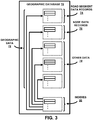
- a geographic database 70 contains data 72 that represents some of the physical geographic features in the geographic region (52 in Figure 2 ).
- the data 72 contained in the geographic database 70 includes data that represent the road network 58.
- the geographic database 70 that represents the geographic region 52 contains at least one database record 74 (also referred to as "entity" or "entry") for each road segment 60 in the geographic region 52 in Figure 2 .
- the road segment data record 74 may include a segment ID by which the data record can be identified in the geographic database 70.
- Each road segment data record 74 has associated with it information (such as "attributes”, “fields”, etc.) that describes features of the represented road segment.
- the road segment data record 74 may include data that indicate the restrictions, if any, on the direction of vehicular travel permitted on the represented road segment, data indicating a speed limit or speed category (i.e., the maximum permitted vehicular speed of travel) on the represented road segment, data indicating whether the represented road segment is part of a controlled access road (such as an expressway), a ramp to a controlled access road, a bridge, a tunnel, a toll road, a ferry, and so on.
- a controlled access road such as an expressway
- the road segment data record 74 also includes data providing the geographic coordinates (e.g., the latitude and longitude) of the endpoints of the represented road segment and data providing the shape of the road segment.
- the endpoint data are references to the node data records 76 that represent the nodes corresponding to the endpoints of the represented road segment.
- the road segment data record 74 may also include or be associated with other data that refer to various other attributes of the represented road segment.
- the various attributes associated with a road segment may be included in a single road segment record, or may be included in more than one type of record that are cross-referenced to each other.
- the road segment data record 74 may include data identifying what turn restrictions exist at each of the nodes that correspond to intersections at the ends of the road portion represented by the road segment, the name or names by which the represented road segment is known, the street address ranges along the represented road segment, and so on.
- the geographic database 70 that represents the geographic region 52 also includes a database record 76 (or "entity” or “entry”) for each node 62 in the geographic region 52.
- entity or “entry”
- Each of the node data records 76 may have associated information (such as “attributes”, “fields”, etc.) that allows identification of the road segment(s) that connect to it and/or its geographic position (e.g., its latitude and longitude coordinates).
- the geographic database 70 may also include other kinds of data 78.
- the other kinds of data 78 may represent other kinds of geographic features or anything else.
- the other kinds of data may include point of interest data.
- the point of interest data may include point of interest records comprising a type (e.g., the type of point of interest, such as restaurant, hotel, city hall, police station, historical marker, ATM, golf course, etc.), location of the point of interest, a phone number, hours of operation, etc.
- Each point of interest has a unique physical location and each of the locations can be identified by its two dimensional (or three dimensional) geographic coordinates, (i.e., latitude, longitude, and optionally altitude). Additionally, the locations may correspond to one of the nodes or may correspond to a point along a road segment.
- the geographic database 70 also includes indexes 80.
- the indexes 80 may include various types of indexes that relate the different types of data to each other or that relate to other aspects of the data contained in the geographic database 70.
- FIG 4 is a block diagram of a full text search (FTS) system 400.
- the FTS system 400 includes a relation table 402 and a spatial index 404.
- the relation table 402 maps tokens to token identifiers.
- the token identifier is an integer value.
- the token identifier may be any combination of numbers, letters, and/or symbols.
- the spatial index 404 indexes multi-dimensional information.
- the spatial index 404 may be an R-tree, X-tree, IQ-tree, Quadtree, or other spatial index structure. If the number of dimensions is small (e.g., less than six), the R-tree is the preferred index structure. If the number of dimensions is large (e.g., more than six), other index structures may be preferable, such as the X-tree or IQ-tree.
- the FTS system 400 may be used in the navigation system 10 as part of destination selection. In this example, some or all of the FTS system 400 may be included as part of the destination selection program 32.
- the documents may be streets, intersections, POIs, and other potential destinations stored in the geographic database 26.
- each FTS index is modeled as a virtual table.
- the virtual table VT(id,att1,..,attn) contains a document identifier "id" and attributes "att1,.., attn.”
- FTS3 allows a user to retrieve documents where query tokens occur in any of the attributes or in specific attributes. For example, a document may have one of the following formats.
- VT_Intersections (IntersectionID, State, City, Streetl, Street2) to show the difference between a full text search system using an inverted index and the FTS system 400.
- the VT_Intersections table may be populated as follows. VT_Intersections IntersectionID State City Street1 Street2 4711 California Los Angeles Jefferson Madison 4712 California Los Angeles Jefferson Washington 6000 California San Diego Sanchez Alfredo 999883 Florida Miami Jefferson Washington 999884 Florida Miami Franklin Frankfurt
- VT_Intersections table Using the VT_Intersections table, a full text search system using an inverted index may issue queries similar to Query 1 and Query 2 as follows.
- the FTS system 400 retrieves all documents that include the token "Washington.”
- the FTS system 400 retrieves only the documents that include the token "Washington” in the City column.
- documents associated with the intersection identifiers 4712 and 999883 belong to the first result set, but not to the second result set.
- each token in the VT_Intersections table is mapped to a token identifier in the relation table 402.
- An example relation table 402, Token2ID is provided as follows. Token2ID Token Token ID Alfredo 1 California 2 Florida 3 Frankfurt 4 Franklin 5 Jefferson 6 Los Angeles 7 Madison 8 Miami 9 Sanchez 10 San Diego 11 Washington 12 ...
- the token identifier is an integer value; however, other formats may be used.
- the tokens are preferably listed alphabetically in the relation table 402 as depicted above in the Token2ID table. However, an alphabetical token order is not required.
- the FTS system 400 stores documents associated with the VT_Intersections table in the spatial index 404.
- the documents are modeled as low-dimensional vectors prior to storage in the spatial index 404.
- An example spatial index 404 for the VT_Intersections table is provided as follows.
- the spatial index 404 is a four-dimensional R-tree where each entry consists of a document identifier, i.e., IntersectionID, and four spatial dimensions, i.e., StateID, CityID, Street1ID and Street2ID.
- RTree_Intersections IntersectionID StateID CityID Street1ID Street2ID 4711 2 7 6 8 4712 2 7 6 12 6000 2 11 10 1 999883 3 9 6 12 999884 3 9 5 4
- the FTS system 400 uses the Token2ID table to obtain the token identifiers for California and Jefferson, which are 2 and 6, respectively. The FTS system 400 then issues the following a spatial query.
- the FTS system 400 retrieves all document identifiers associated with the documents inside the boxed area of the spatial index 404 specified in the query. In this example, the FTS system 400 provides the result set of 4711 and 4712.
- the FTS system 400 may be used for other types of searches, such as street and POI searches.
- the spatial index 404 includes a three-dimensional R-tree: Rtree_Streets (StreetID, Country, City, Street). For example, if a user enters "Deutschland” as a country name and "Volger" as a street name into the user interface 24, the FTS system 400 may execute the following box-query.
- the FTS system 400 includes a four-dimensional R-tree: Rtree_POIs (POIID, Name, Country, Street, Category). For example, if a user enters the country and POI name, the FTS system 400 may execute the following box-query.
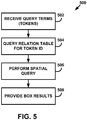
- FIG. 5 is a flow diagram of a method 500 for performing a full text search using the FTS system 400.
- the FTS system 400 receives query terms from a user.
- the user may be a user of the navigation system 10 and the query terms are words used to find a destination (e.g., street name, point of interest name).
- the user may enter the query terms via the user interface 24.
- these query terms are referred to as tokens.
- the FTS system 400 queries the relation table 402 to obtain the token identifiers associated with each of the tokens entered by the user.
- the tokens are country names, city names, street names, point of interest names, and other terms used to locate a destination.
- the relation table 402 maps the tokens (e.g., Germany, Kunststoff, Berlin, Hauptstrasse, and Leopoldstrasse) to a token identifier.
- the FTS system 400 performs a spatial query of the spatial index 404 using the token identifiers obtained at block 504.
- each level of the destination is mapped to its own dimension, e.g., Country to X, City to Y, and Street to Z.
- Each document is then mapped to an n-dimensional vector using the token identifiers.
- the document is an entry in the geographic database 26.
- the document (Germany, Kunststoff, Leopoldstrasse) may be mapped to a 3-dimensional vector (token2id(Germany), token2id(Munich), token2id(Leopoldstrasse)), which is stored in the spatial index 404. If a user enters a StreetToken and a CityToken in the user interface 24, the FTS system 400 retrieves responsive documents by executing the following three-dimensional spatial window query.
- the FTS system 400 provides the result set of document identifiers associated with responsive documents located in the boxed area of the spatial index 404 as defined by the query.
- the FTS system 400 may provide the result set to another system, which then retrieves the documents and provides the documents to the user.
- the FTS system 400 may retrieve the documents associated with the document identifier and then provide the documents to the user.
- the FTS system 400 does not include the relation table 402.
- the FTS system 400 algorithmically maps the tokens to token identifiers using a mapping function.
- the FTS system 400 stores the documents as multi-dimensional vectors in the spatial index 404 as previously described.
- the FTS system 400 uses the token identifiers generated by the mapping function as query tokens when performing the spatial query.
- an algorithmically mapping of a token (i.e., strings) to a token identifier may be performed by taking the first eight bytes of a string and interpreting this byte array as an eight byte integer value. If the string consists of less than eight bytes, the string may be appended with zero bytes.
- Additional dimensions may be added to the spatial index 404.
- dimensions such as latitude and longitude, may be added to the previously described RTree_Intersections table.
- the resulting six-dimensional RTree_Intersections table is provided as follows. Six-Dimensional RTree_Intersections IntersectionID StateID CityID Street1ID Street2ID Latitude Longitude 4711 2 7 6 8 12343453 3453453 4712 2 7 6 12 12334243 6857567 6000 2 11 10 1 54645644 4563455 999883 3 9 6 12 34636363 3463463 999884 3 9 5 4 35342432 342423434
- the FTS system 400 retrieves the two token identifiers 2 and 6 as described previously. But because the FTS system 400 does not know the token dimensions (e.g., whether California is a street, a city, or a state), the FTS system 400 executes several spatial queries by permuting the dimensions of the query box.
- the token dimensions e.g., whether California is a street, a city, or a state
- the FTS system 400 executes twelve sub-queries, the overall performance of the FTS system 400 is still expected to be better than inverted index approach.
- the FTS system 400 may store the documents redundantly by permuting the dimensions of each document and executing a single query. To reduce the secondary storage requirements, it may be beneficial to permute the query objects rather than the database objects. By adding an additional column to the relation table 402 that indicates in which R-tree dimension the token is used, the number of query permutations is reduced.
- the following Token2ID table provides an example of adding a dimension column. Token2ID with Dimension Token Dimension ID Miami 2 9 Miami 3 34532 Miami 4 34532 State 3 6456 State 4 6457
- the token "Miami” may be part of a City name, a Streetl name, or a Street2 name.
- the token "State” may be part of a Streetl name or a Street2 name. If a user enters the token "State" into the user interface 24, the FTS system 400 executes only two sub-queries as follows.
- Name rotations, exonyms, and diacritic character replacement may also be managed via the FTS system 400.
- Name rotations occur when a multi-part name is entered into a search engine out of order. For example, a user searching for documents associated with “Los Angeles” may enter “Angeles” instead. To find responsive documents when a user enters “Angeles” instead of “Los Angeles,” a record is added to the Token2ID table. As seen in the Token2ID table below, "Angeles; Los” is associated with the same token identifier as "Los Angeles.” Token2ID Token Token ID Alfredo 1 Angeles; Los 7 (new entry) California 2 Florida 3 Frankfurt 4 Franklin 5 Jefferson 6 Los Angeles 7 Madison 8 Miami 9 Sanchez 10 San Diego 11 Washington 12 ...
- the FTS system 400 executes a query such as SELECT id FROM Token2ID WHERE Token LIKE 'Angeles%', which returns the same token, i.e. 7, as the query with the token Los Angeles.
- Diacritic character replacement includes substituting the diacritic with another letter; for example, München becomes Muenchen.
- the relation table 402 may be populated as follows. IDTokens Token ID Tokens 1 Germany GmbH Duitsland pertaining 2 Munchen Munchen Muenchen 3 Otto-Volger-Strasse ...
- the FTS system 400 may execute an FTS query based on the entered token to obtain the token identifiers.
- the FTS system 400 uses a traditional FTS system to retrieve the token identifiers. Note that this FTS system typically maintains only thousands of terms, while the FTS system 400 may maintain millions of documents.
- the complexity is in the combination of the tokens stored in the spatial index 404, rather than in the tokens themselves. As a result, the FTS system manages the combination complexity in a manner that the traditional FTS system with inverted index cannot.
- the FTS system 400 may execute the following query.
- IDTokens table may be formatted as follows. IDTokens ID Dimension Tokens 1 1 Germany GmbH Duitsland isse 2 2 Ober Munchen Muenchen 2 3 Ober Munchen Muenchen 3 3 Otto-Volger-Strasse ...
- Munchen is used as both a City name and as a Street name.
- the FTS system 400 and the method 500 save secondary storage and increase query processing speed. As a result, the FTS system 400 and the method 500 are especially beneficial during destination selection with a navigation system. However, it is understood that the FTS system 400 and the method 500 may be used in navigation systems for other full text search applications and in other systems that perform full text searches.
Landscapes
- Engineering & Computer Science (AREA)
- Theoretical Computer Science (AREA)
- General Physics & Mathematics (AREA)
- Databases & Information Systems (AREA)
- Physics & Mathematics (AREA)
- General Engineering & Computer Science (AREA)
- Data Mining & Analysis (AREA)
- Remote Sensing (AREA)
- Radar, Positioning & Navigation (AREA)
- Software Systems (AREA)
- Computational Linguistics (AREA)
- Automation & Control Theory (AREA)
- Information Retrieval, Db Structures And Fs Structures Therefor (AREA)
Claims (14)
- Computerimplementiertes Verfahren (500) zum Durchführen einer Volltextsuche für Dokumente, wobei ein Dokument ein Eintrag in einer geographischen Datenbank (26) in einem Navigationssystem (10) ist, das einer Computerplattform (12) zugeordnet ist und wobei das Navigationssystem eine Kombination aus Hardware- und Softwarekomponenten ist und wobei die Dokumente Dokumentenkennungen zugeordnet sind, wobei das Verfahren Folgendes umfasst:Empfangen (502) von Suchbegriffen von einem Benutzer, wobei die Suchbegriffe Wörter sind, die zum Finden eines Ziels verwendet werden;Abfragen (504) einer Beziehungstabelle (402), welche die empfangenen Suchbegriffe den Suchbegriffskennungen zuordnet, um die den empfangenen Suchbegriffen zugeordneten Suchbegriffskennungen zu erhalten, wobei die Suchbegriffskennungen Ganzzahlwerte sind;Zuordnen der Suchbegriffskennungen für jede Ebene des Ziels zu ihren eigenen Dimensionen;Durchführen (506) einer räumlichen Abfrage eines räumlichen Index (404) unter Verwenden der Suchbegriffskennungen, die ihren eigenen Dimensionen zugeordnet sind, um Dokumente zu identifizieren, die sich in einem umrahmten Bereich des räumlichen Index (404) befinden, wie durch die räumliche Abfrage definiert, und wobei der räumliche Index mehrdimensionale Vektoren speichert, denen jedes Dokument vor dem Speichern im räumlichen Index zugeordnet ist, und wobei die mehrdimensionalen Vektoren die Suchbegriffskennungen enthalten und wobei die mehrdimensionalen Vektoren ein Format von folgenden Formaten aufweisen:(Straßenkennung, Land, Stadt, Straße); oder(Kreuzungskennung, Staat, Stadt, Straße1, Straße2) oder(POIID [Provider of Information ID - Informationsanbieterkennung], Name, Land, Straße, Kategorie), Bereitstellen (508) einer Ergebnismenge von Dokumentenkennungen, die den identifizierten Dokumenten zugeordnet sind.
- Verfahren (500) nach Anspruch 1, wobei die Beziehungstabelle die Suchbegriffe in alphabetischer Reihenfolge anordnet.
- Verfahren (500) nach Anspruch 1, wobei der räumliche Index eines von einem R-Baum, X-Baum, IQ-Baum, und einem Quad-Baum ist.
- Verfahren (500) nach Anspruch 1, wobei die Beziehungstabelle eine Dimensionsspalte enthält, die Daten enthält, die eine Suchbegriffsdimension angeben.
- Verfahren (500) nach Anspruch 1, wobei die Beziehungstabelle Namensrotationen oder Exonyme oder diakritische Zeichenersetzungen enthält.
- Verfahren (500) nach Anspruch 1, wobei der räumliche Index zusätzliche Dimensionen enthält, die eine räumliche Position eines Ziels beschreiben, das durch einen Vektor dargestellt wird.
- Volltext-Suchsystem (400) für Dokumente, wobei ein Dokument ein Eintrag in einer geographischen Datenbank (26) in einem Navigationssystem (10) ist, das einer Computerplattform (12) zugeordnet ist und wobei das Navigationssystem eine Kombination aus Hardware- und Softwarekomponenten ist und wobei die Dokumente Dokumentenkennungen zugeordnet sind, wobei das System umfasst:eine Beziehungstabelle (402), die von einem Benutzer empfangene Suchbegriffe mit Suchbegriffskennungen verknüpft, wobei die Suchbegriffe Wörter sind, die zum Finden eines Ziels verwendet werden, und die Suchbegriffskennungen ganzzahlige Werte sind; undeinen räumlichen Index (404), der mehrdimensionale Vektoren enthält, denen jedes Dokument vor dem Speichern im räumlichen Index zugeordnet ist, die Ziele darstellen, wobeidie mehrdimensionalen Vektoren die Suchbegriffskennungen enthalten; unddie mehrdimensionalen Vektoren ein Format von folgenden Formaten aufweisen:(Straßenkennung, Land, Stadt, Straße); oder(Kreuzungskennung, Staat, Stadt, Straße1, Straße2) oder(POIID, Name, Land, Straße, Kategorie) und wobei das System für Folgendes konfiguriert ist:Zuordnen der Suchbegriffskennungen zu jeder Ebene des Ziels zu ihrer eigenen Dimension;Verwenden der Suchbegriffskennungen, die ihren eigenen Dimensionen zugeordnet sind, um Dokumente zu identifizieren, die sich in einem umrahmten Bereich des räumlichen Index befinden, wie durch eine räumliche Abfrage definiert; undeine Ergebnismenge von Dokumentenkennungen bereitstellen, die den identifizierten Dokumenten zugeordnet sind.
- System (400) nach Anspruch 7, wobei die Beziehungstabelle die Suchbegriffe in alphabetischer Reihenfolge anordnet.
- System (400) nach Anspruch 7, wobei die Beziehungstabelle (402) eine Dimensionsspalte enthält, die Daten enthält, welche eine Suchbegriffsdimension angeben.
- System (400) nach Anspruch 7, wobei die Beziehungstabelle (402) Namensrotationen enthält.
- System (400) nach Anspruch 7, wobei die Beziehungstabelle (402) Exonyme enthält.
- System (400) nach Anspruch 7, wobei die Beziehungstabelle (402) Ersetzungen diakritischer Zeichen enthält.
- System (400) nach Anspruch 7, wobei der räumliche Index (404) zusätzliche Dimensionen enthält, die eine räumliche Position eines Ziels beschreiben, das durch einen Vektor dargestellt wird.
- System (400) nach Anspruch 7, wobei der räumliche Index ein von einem R-Baum, X-Baum, IQ-Baum, und einem Quad-Baum ist.
Applications Claiming Priority (2)
| Application Number | Priority Date | Filing Date | Title |
|---|---|---|---|
| US30231710P | 2010-02-08 | 2010-02-08 | |
| US13/017,296 US20110196602A1 (en) | 2010-02-08 | 2011-01-31 | Destination search in a navigation system using a spatial index structure |
Publications (2)
| Publication Number | Publication Date |
|---|---|
| EP2363816A1 EP2363816A1 (de) | 2011-09-07 |
| EP2363816B1 true EP2363816B1 (de) | 2019-06-19 |
Family
ID=44223585
Family Applications (1)
| Application Number | Title | Priority Date | Filing Date |
|---|---|---|---|
| EP11153571.2A Active EP2363816B1 (de) | 2010-02-08 | 2011-02-07 | Zielsuche in einem Navigationssystem mit einer räumlichen Indexstruktur |
Country Status (2)
| Country | Link |
|---|---|
| US (1) | US20110196602A1 (de) |
| EP (1) | EP2363816B1 (de) |
Families Citing this family (18)
| Publication number | Priority date | Publication date | Assignee | Title |
|---|---|---|---|---|
| US9275059B1 (en) * | 2011-11-07 | 2016-03-01 | Emc Corporation | Genome big data indexing |
| US8745022B2 (en) | 2011-11-22 | 2014-06-03 | Navteq B.V. | Full text search based on interwoven string tokens |
| US8738595B2 (en) | 2011-11-22 | 2014-05-27 | Navteq B.V. | Location based full text search |
| US8700661B2 (en) * | 2012-04-12 | 2014-04-15 | Navteq B.V. | Full text search using R-trees |
| US8751526B1 (en) * | 2012-08-29 | 2014-06-10 | Bentley Systems, Incorporated | Efficient range unions in SQL |
| GB201306937D0 (en) * | 2013-04-17 | 2013-05-29 | Tomtom Int Bv | Methods, devices and computer software for facilitating searching and display of locations relevant to a digital map |
| GB201306942D0 (en) * | 2013-04-17 | 2013-05-29 | Tomtom Int Bv | Methods, devices and computer software for facilitating searching and display of locations relevant to a digital map |
| GB201306944D0 (en) | 2013-04-17 | 2013-05-29 | Tomtom Int Bv | Methods, devices and computer software for facilitating searching and display of locations relevant to a digital map |
| US10169370B2 (en) | 2013-06-14 | 2019-01-01 | Here Global B.V. | Navigation database customization |
| CN103714192B (zh) * | 2013-07-18 | 2016-06-22 | 铁道第三勘察设计院集团有限公司 | 基于自适应r-树的大数据量铁路三维设计模型渲染方法 |
| CN104731854B (zh) * | 2013-12-18 | 2020-02-04 | 哈曼国际工业有限公司 | 语音识别查询响应系统 |
| RU2606309C2 (ru) | 2015-06-09 | 2017-01-10 | Общество С Ограниченной Ответственностью "Яндекс" | Способ создания аннотированного поискового индекса и сервер, используемый в нем |
| US10445347B2 (en) | 2015-11-13 | 2019-10-15 | International Business Machines Corporation | Positional route guidance |
| CN106997354B (zh) * | 2016-01-25 | 2020-07-28 | 北京四维图新科技股份有限公司 | 一种poi数据检索方法及装置 |
| CN106021276A (zh) * | 2016-04-28 | 2016-10-12 | 泰华智慧产业集团股份有限公司 | 基于分布式全文检索系统的卡口车辆搜索的方法及系统 |
| CN108446280A (zh) * | 2017-02-06 | 2018-08-24 | 北京嘀嘀无限科技发展有限公司 | 数据更新方法及装置 |
| CN112417322B (zh) * | 2020-12-10 | 2024-03-22 | 长春理工大学 | 一种面向兴趣点名称文本的类型判别方法及系统 |
| CN119474147B (zh) * | 2024-10-12 | 2025-09-12 | 中国人民解放军96911部队 | 基于模型的路网及地名要素信息的快速检索方法及系统 |
Family Cites Families (26)
| Publication number | Priority date | Publication date | Assignee | Title |
|---|---|---|---|---|
| US5666442A (en) * | 1993-05-23 | 1997-09-09 | Infoglide Corporation | Comparison system for identifying the degree of similarity between objects by rendering a numeric measure of closeness, the system including all available information complete with errors and inaccuracies |
| US5784059A (en) * | 1994-09-16 | 1998-07-21 | Aisin Aw Co., Ltd. | Vehicle navigation system with destination selection using hierarchical menu arrangement with selective level skipping |
| US5963956A (en) * | 1997-02-27 | 1999-10-05 | Telcontar | System and method of optimizing database queries in two or more dimensions |
| US6081803A (en) * | 1998-02-06 | 2000-06-27 | Navigation Technologies Corporation | Support for alternative names in a geographic database used with a navigation program and methods for use and formation thereof |
| US6684221B1 (en) * | 1999-05-06 | 2004-01-27 | Oracle International Corporation | Uniform hierarchical information classification and mapping system |
| CA2400161C (en) * | 2000-02-22 | 2015-11-24 | Metacarta, Inc. | Spatially coding and displaying information |
| US6728706B2 (en) * | 2001-03-23 | 2004-04-27 | International Business Machines Corporation | Searching products catalogs |
| US7117434B2 (en) * | 2001-06-29 | 2006-10-03 | International Business Machines Corporation | Graphical web browsing interface for spatial data navigation and method of navigating data blocks |
| US7373353B2 (en) * | 2002-05-10 | 2008-05-13 | International Business Machines Corporation | Reducing index size for multi-level grid indexes |
| US7366736B1 (en) * | 2003-05-19 | 2008-04-29 | Diamond Visionics L.L.C. | Method and system for generating real-time simulator database |
| US7239989B2 (en) * | 2003-07-18 | 2007-07-03 | Oracle International Corporation | Within-distance query pruning in an R-tree index |
| US7370037B2 (en) * | 2003-12-29 | 2008-05-06 | International Business Machines Corporation | Methods for processing a text search query in a collection of documents |
| US7337165B2 (en) * | 2003-12-29 | 2008-02-26 | International Business Machines Corporation | Method and system for processing a text search query in a collection of documents |
| US20050278378A1 (en) * | 2004-05-19 | 2005-12-15 | Metacarta, Inc. | Systems and methods of geographical text indexing |
| US7917480B2 (en) * | 2004-08-13 | 2011-03-29 | Google Inc. | Document compression system and method for use with tokenspace repository |
| US20060041375A1 (en) * | 2004-08-19 | 2006-02-23 | Geographic Data Technology, Inc. | Automated georeferencing of digitized map images |
| US20060143171A1 (en) * | 2004-12-29 | 2006-06-29 | International Business Machines Corporation | System and method for processing a text search query in a collection of documents |
| AU2005201758B2 (en) * | 2005-04-27 | 2008-12-18 | Canon Kabushiki Kaisha | Method of learning associations between documents and data sets |
| US7747598B2 (en) * | 2006-01-27 | 2010-06-29 | Google Inc. | Geographic coding for location search queries |
| US7606875B2 (en) * | 2006-03-28 | 2009-10-20 | Microsoft Corporation | Detecting serving area of a web resource |
| US20080270396A1 (en) * | 2007-04-25 | 2008-10-30 | Michael Herscovici | Indexing versioned document sequences |
| US20080306949A1 (en) * | 2007-06-08 | 2008-12-11 | John Martin Hoernkvist | Inverted index processing |
| US7853598B2 (en) * | 2007-10-01 | 2010-12-14 | Sap Ag | Compressed storage of documents using inverted indexes |
| US9477717B2 (en) * | 2008-03-31 | 2016-10-25 | Yahoo! Inc. | Cross-domain matching system |
| US8473279B2 (en) * | 2008-05-30 | 2013-06-25 | Eiman Al-Shammari | Lemmatizing, stemming, and query expansion method and system |
| US9009177B2 (en) * | 2009-09-25 | 2015-04-14 | Microsoft Corporation | Recommending points of interests in a region |
-
2011
- 2011-01-31 US US13/017,296 patent/US20110196602A1/en not_active Abandoned
- 2011-02-07 EP EP11153571.2A patent/EP2363816B1/de active Active
Non-Patent Citations (1)
| Title |
|---|
| None * |
Also Published As
| Publication number | Publication date |
|---|---|
| US20110196602A1 (en) | 2011-08-11 |
| EP2363816A1 (de) | 2011-09-07 |
Similar Documents
| Publication | Publication Date | Title |
|---|---|---|
| EP2363816A1 (de) | Zielsuche in einem Navigationssystem mit einer räumlichen Indexstruktur | |
| US8738595B2 (en) | Location based full text search | |
| EP1365212B1 (de) | Vorrichtung und Verfahren zum Speichern von geographischen Daten auf einem physikalischen Speichermedium | |
| US6600841B1 (en) | Method and system for compressing data and a geographic database formed therewith and methods for use thereof in a navigation application program | |
| US8620577B2 (en) | System and method for searching for points of interest along a route | |
| US20070276845A1 (en) | Locality indexes and method for indexing localities | |
| EP2836928B1 (de) | Volltextsuche mit r-trees | |
| US20030165254A1 (en) | Adapting point geometry for storing address density | |
| KR20090028705A (ko) | 가변 압축을 가지는 적응형 인덱스 | |
| EP2354984B1 (de) | Volltextsuche in Navigationssystemen | |
| EP2783308B1 (de) | Volltextsuche in verwebten kettentokens | |
| US10984025B2 (en) | Device and method for displaying and searching for location by using grid and words | |
| Clemens | Automated processing of postal addresses | |
| Khine | The Efficient Geospatial Index Structure for Spatial Keyword Query with Myanmar Language on Mobile Devices |
Legal Events
| Date | Code | Title | Description |
|---|---|---|---|
| PUAI | Public reference made under article 153(3) epc to a published international application that has entered the european phase |
Free format text: ORIGINAL CODE: 0009012 |
|
| AK | Designated contracting states |
Kind code of ref document: A1 Designated state(s): AL AT BE BG CH CY CZ DE DK EE ES FI FR GB GR HR HU IE IS IT LI LT LU LV MC MK MT NL NO PL PT RO RS SE SI SK SM TR |
|
| AX | Request for extension of the european patent |
Extension state: BA ME |
|
| 17P | Request for examination filed |
Effective date: 20120306 |
|
| RAP1 | Party data changed (applicant data changed or rights of an application transferred) |
Owner name: NAVTEQ B.V. |
|
| RAP1 | Party data changed (applicant data changed or rights of an application transferred) |
Owner name: HERE GLOBAL B.V. |
|
| RAP1 | Party data changed (applicant data changed or rights of an application transferred) |
Owner name: HERE GLOBAL B.V. |
|
| STAA | Information on the status of an ep patent application or granted ep patent |
Free format text: STATUS: EXAMINATION IS IN PROGRESS |
|
| 17Q | First examination report despatched |
Effective date: 20170727 |
|
| GRAP | Despatch of communication of intention to grant a patent |
Free format text: ORIGINAL CODE: EPIDOSNIGR1 |
|
| STAA | Information on the status of an ep patent application or granted ep patent |
Free format text: STATUS: GRANT OF PATENT IS INTENDED |
|
| INTG | Intention to grant announced |
Effective date: 20180626 |
|
| GRAJ | Information related to disapproval of communication of intention to grant by the applicant or resumption of examination proceedings by the epo deleted |
Free format text: ORIGINAL CODE: EPIDOSDIGR1 |
|
| STAA | Information on the status of an ep patent application or granted ep patent |
Free format text: STATUS: EXAMINATION IS IN PROGRESS |
|
| INTC | Intention to grant announced (deleted) | ||
| GRAP | Despatch of communication of intention to grant a patent |
Free format text: ORIGINAL CODE: EPIDOSNIGR1 |
|
| STAA | Information on the status of an ep patent application or granted ep patent |
Free format text: STATUS: GRANT OF PATENT IS INTENDED |
|
| INTG | Intention to grant announced |
Effective date: 20190211 |
|
| GRAS | Grant fee paid |
Free format text: ORIGINAL CODE: EPIDOSNIGR3 |
|
| GRAA | (expected) grant |
Free format text: ORIGINAL CODE: 0009210 |
|
| STAA | Information on the status of an ep patent application or granted ep patent |
Free format text: STATUS: THE PATENT HAS BEEN GRANTED |
|
| AK | Designated contracting states |
Kind code of ref document: B1 Designated state(s): AL AT BE BG CH CY CZ DE DK EE ES FI FR GB GR HR HU IE IS IT LI LT LU LV MC MK MT NL NO PL PT RO RS SE SI SK SM TR |
|
| REG | Reference to a national code |
Ref country code: GB Ref legal event code: FG4D |
|
| REG | Reference to a national code |
Ref country code: CH Ref legal event code: EP |
|
| REG | Reference to a national code |
Ref country code: IE Ref legal event code: FG4D |
|
| REG | Reference to a national code |
Ref country code: AT Ref legal event code: REF Ref document number: 1146406 Country of ref document: AT Kind code of ref document: T Effective date: 20190715 |
|
| REG | Reference to a national code |
Ref country code: DE Ref legal event code: R096 Ref document number: 602011059779 Country of ref document: DE |
|
| REG | Reference to a national code |
Ref country code: NL Ref legal event code: MP Effective date: 20190619 |
|
| PG25 | Lapsed in a contracting state [announced via postgrant information from national office to epo] |
Ref country code: NO Free format text: LAPSE BECAUSE OF FAILURE TO SUBMIT A TRANSLATION OF THE DESCRIPTION OR TO PAY THE FEE WITHIN THE PRESCRIBED TIME-LIMIT Effective date: 20190919 Ref country code: LT Free format text: LAPSE BECAUSE OF FAILURE TO SUBMIT A TRANSLATION OF THE DESCRIPTION OR TO PAY THE FEE WITHIN THE PRESCRIBED TIME-LIMIT Effective date: 20190619 Ref country code: SE Free format text: LAPSE BECAUSE OF FAILURE TO SUBMIT A TRANSLATION OF THE DESCRIPTION OR TO PAY THE FEE WITHIN THE PRESCRIBED TIME-LIMIT Effective date: 20190619 Ref country code: HR Free format text: LAPSE BECAUSE OF FAILURE TO SUBMIT A TRANSLATION OF THE DESCRIPTION OR TO PAY THE FEE WITHIN THE PRESCRIBED TIME-LIMIT Effective date: 20190619 Ref country code: AL Free format text: LAPSE BECAUSE OF FAILURE TO SUBMIT A TRANSLATION OF THE DESCRIPTION OR TO PAY THE FEE WITHIN THE PRESCRIBED TIME-LIMIT Effective date: 20190619 Ref country code: FI Free format text: LAPSE BECAUSE OF FAILURE TO SUBMIT A TRANSLATION OF THE DESCRIPTION OR TO PAY THE FEE WITHIN THE PRESCRIBED TIME-LIMIT Effective date: 20190619 |
|
| REG | Reference to a national code |
Ref country code: LT Ref legal event code: MG4D |
|
| PG25 | Lapsed in a contracting state [announced via postgrant information from national office to epo] |
Ref country code: GR Free format text: LAPSE BECAUSE OF FAILURE TO SUBMIT A TRANSLATION OF THE DESCRIPTION OR TO PAY THE FEE WITHIN THE PRESCRIBED TIME-LIMIT Effective date: 20190920 Ref country code: LV Free format text: LAPSE BECAUSE OF FAILURE TO SUBMIT A TRANSLATION OF THE DESCRIPTION OR TO PAY THE FEE WITHIN THE PRESCRIBED TIME-LIMIT Effective date: 20190619 Ref country code: RS Free format text: LAPSE BECAUSE OF FAILURE TO SUBMIT A TRANSLATION OF THE DESCRIPTION OR TO PAY THE FEE WITHIN THE PRESCRIBED TIME-LIMIT Effective date: 20190619 Ref country code: BG Free format text: LAPSE BECAUSE OF FAILURE TO SUBMIT A TRANSLATION OF THE DESCRIPTION OR TO PAY THE FEE WITHIN THE PRESCRIBED TIME-LIMIT Effective date: 20190919 |
|
| REG | Reference to a national code |
Ref country code: AT Ref legal event code: MK05 Ref document number: 1146406 Country of ref document: AT Kind code of ref document: T Effective date: 20190619 |
|
| PG25 | Lapsed in a contracting state [announced via postgrant information from national office to epo] |
Ref country code: SK Free format text: LAPSE BECAUSE OF FAILURE TO SUBMIT A TRANSLATION OF THE DESCRIPTION OR TO PAY THE FEE WITHIN THE PRESCRIBED TIME-LIMIT Effective date: 20190619 Ref country code: CZ Free format text: LAPSE BECAUSE OF FAILURE TO SUBMIT A TRANSLATION OF THE DESCRIPTION OR TO PAY THE FEE WITHIN THE PRESCRIBED TIME-LIMIT Effective date: 20190619 Ref country code: RO Free format text: LAPSE BECAUSE OF FAILURE TO SUBMIT A TRANSLATION OF THE DESCRIPTION OR TO PAY THE FEE WITHIN THE PRESCRIBED TIME-LIMIT Effective date: 20190619 Ref country code: NL Free format text: LAPSE BECAUSE OF FAILURE TO SUBMIT A TRANSLATION OF THE DESCRIPTION OR TO PAY THE FEE WITHIN THE PRESCRIBED TIME-LIMIT Effective date: 20190619 Ref country code: PT Free format text: LAPSE BECAUSE OF FAILURE TO SUBMIT A TRANSLATION OF THE DESCRIPTION OR TO PAY THE FEE WITHIN THE PRESCRIBED TIME-LIMIT Effective date: 20191021 Ref country code: EE Free format text: LAPSE BECAUSE OF FAILURE TO SUBMIT A TRANSLATION OF THE DESCRIPTION OR TO PAY THE FEE WITHIN THE PRESCRIBED TIME-LIMIT Effective date: 20190619 Ref country code: AT Free format text: LAPSE BECAUSE OF FAILURE TO SUBMIT A TRANSLATION OF THE DESCRIPTION OR TO PAY THE FEE WITHIN THE PRESCRIBED TIME-LIMIT Effective date: 20190619 |
|
| PG25 | Lapsed in a contracting state [announced via postgrant information from national office to epo] |
Ref country code: IT Free format text: LAPSE BECAUSE OF FAILURE TO SUBMIT A TRANSLATION OF THE DESCRIPTION OR TO PAY THE FEE WITHIN THE PRESCRIBED TIME-LIMIT Effective date: 20190619 Ref country code: SM Free format text: LAPSE BECAUSE OF FAILURE TO SUBMIT A TRANSLATION OF THE DESCRIPTION OR TO PAY THE FEE WITHIN THE PRESCRIBED TIME-LIMIT Effective date: 20190619 Ref country code: ES Free format text: LAPSE BECAUSE OF FAILURE TO SUBMIT A TRANSLATION OF THE DESCRIPTION OR TO PAY THE FEE WITHIN THE PRESCRIBED TIME-LIMIT Effective date: 20190619 Ref country code: IS Free format text: LAPSE BECAUSE OF FAILURE TO SUBMIT A TRANSLATION OF THE DESCRIPTION OR TO PAY THE FEE WITHIN THE PRESCRIBED TIME-LIMIT Effective date: 20191019 |
|
| PG25 | Lapsed in a contracting state [announced via postgrant information from national office to epo] |
Ref country code: TR Free format text: LAPSE BECAUSE OF FAILURE TO SUBMIT A TRANSLATION OF THE DESCRIPTION OR TO PAY THE FEE WITHIN THE PRESCRIBED TIME-LIMIT Effective date: 20190619 |
|
| PG25 | Lapsed in a contracting state [announced via postgrant information from national office to epo] |
Ref country code: PL Free format text: LAPSE BECAUSE OF FAILURE TO SUBMIT A TRANSLATION OF THE DESCRIPTION OR TO PAY THE FEE WITHIN THE PRESCRIBED TIME-LIMIT Effective date: 20190619 Ref country code: DK Free format text: LAPSE BECAUSE OF FAILURE TO SUBMIT A TRANSLATION OF THE DESCRIPTION OR TO PAY THE FEE WITHIN THE PRESCRIBED TIME-LIMIT Effective date: 20190619 |
|
| PG25 | Lapsed in a contracting state [announced via postgrant information from national office to epo] |
Ref country code: IS Free format text: LAPSE BECAUSE OF FAILURE TO SUBMIT A TRANSLATION OF THE DESCRIPTION OR TO PAY THE FEE WITHIN THE PRESCRIBED TIME-LIMIT Effective date: 20200224 |
|
| REG | Reference to a national code |
Ref country code: DE Ref legal event code: R097 Ref document number: 602011059779 Country of ref document: DE |
|
| PLBE | No opposition filed within time limit |
Free format text: ORIGINAL CODE: 0009261 |
|
| STAA | Information on the status of an ep patent application or granted ep patent |
Free format text: STATUS: NO OPPOSITION FILED WITHIN TIME LIMIT |
|
| PG2D | Information on lapse in contracting state deleted |
Ref country code: IS |
|
| 26N | No opposition filed |
Effective date: 20200603 |
|
| PG25 | Lapsed in a contracting state [announced via postgrant information from national office to epo] |
Ref country code: SI Free format text: LAPSE BECAUSE OF FAILURE TO SUBMIT A TRANSLATION OF THE DESCRIPTION OR TO PAY THE FEE WITHIN THE PRESCRIBED TIME-LIMIT Effective date: 20190619 |
|
| REG | Reference to a national code |
Ref country code: CH Ref legal event code: PL |
|
| GBPC | Gb: european patent ceased through non-payment of renewal fee |
Effective date: 20200207 |
|
| REG | Reference to a national code |
Ref country code: BE Ref legal event code: MM Effective date: 20200229 |
|
| PG25 | Lapsed in a contracting state [announced via postgrant information from national office to epo] |
Ref country code: LU Free format text: LAPSE BECAUSE OF NON-PAYMENT OF DUE FEES Effective date: 20200207 Ref country code: MC Free format text: LAPSE BECAUSE OF FAILURE TO SUBMIT A TRANSLATION OF THE DESCRIPTION OR TO PAY THE FEE WITHIN THE PRESCRIBED TIME-LIMIT Effective date: 20190619 |
|
| PG25 | Lapsed in a contracting state [announced via postgrant information from national office to epo] |
Ref country code: CH Free format text: LAPSE BECAUSE OF NON-PAYMENT OF DUE FEES Effective date: 20200229 Ref country code: LI Free format text: LAPSE BECAUSE OF NON-PAYMENT OF DUE FEES Effective date: 20200229 |
|
| PG25 | Lapsed in a contracting state [announced via postgrant information from national office to epo] |
Ref country code: FR Free format text: LAPSE BECAUSE OF NON-PAYMENT OF DUE FEES Effective date: 20200229 Ref country code: GB Free format text: LAPSE BECAUSE OF NON-PAYMENT OF DUE FEES Effective date: 20200207 Ref country code: IE Free format text: LAPSE BECAUSE OF NON-PAYMENT OF DUE FEES Effective date: 20200207 |
|
| PG25 | Lapsed in a contracting state [announced via postgrant information from national office to epo] |
Ref country code: BE Free format text: LAPSE BECAUSE OF NON-PAYMENT OF DUE FEES Effective date: 20200229 |
|
| PG25 | Lapsed in a contracting state [announced via postgrant information from national office to epo] |
Ref country code: MT Free format text: LAPSE BECAUSE OF FAILURE TO SUBMIT A TRANSLATION OF THE DESCRIPTION OR TO PAY THE FEE WITHIN THE PRESCRIBED TIME-LIMIT Effective date: 20190619 Ref country code: CY Free format text: LAPSE BECAUSE OF FAILURE TO SUBMIT A TRANSLATION OF THE DESCRIPTION OR TO PAY THE FEE WITHIN THE PRESCRIBED TIME-LIMIT Effective date: 20190619 |
|
| PG25 | Lapsed in a contracting state [announced via postgrant information from national office to epo] |
Ref country code: MK Free format text: LAPSE BECAUSE OF FAILURE TO SUBMIT A TRANSLATION OF THE DESCRIPTION OR TO PAY THE FEE WITHIN THE PRESCRIBED TIME-LIMIT Effective date: 20190619 |
|
| P01 | Opt-out of the competence of the unified patent court (upc) registered |
Effective date: 20230517 |
|
| PGFP | Annual fee paid to national office [announced via postgrant information from national office to epo] |
Ref country code: DE Payment date: 20251216 Year of fee payment: 16 |