EP2365284A2 - Procédé de navigation en temps réel pour un environnement mobile - Google Patents
Procédé de navigation en temps réel pour un environnement mobile Download PDFInfo
- Publication number
- EP2365284A2 EP2365284A2 EP11166983A EP11166983A EP2365284A2 EP 2365284 A2 EP2365284 A2 EP 2365284A2 EP 11166983 A EP11166983 A EP 11166983A EP 11166983 A EP11166983 A EP 11166983A EP 2365284 A2 EP2365284 A2 EP 2365284A2
- Authority
- EP
- European Patent Office
- Prior art keywords
- user
- information
- navigational
- location
- uncertainty
- Prior art date
- Legal status (The legal status is an assumption and is not a legal conclusion. Google has not performed a legal analysis and makes no representation as to the accuracy of the status listed.)
- Granted
Links
Images




Classifications
-
- G—PHYSICS
- G08—SIGNALLING
- G08G—TRAFFIC CONTROL SYSTEMS
- G08G1/00—Traffic control systems for road vehicles
- G08G1/09—Arrangements for giving variable traffic instructions
- G08G1/0962—Arrangements for giving variable traffic instructions having an indicator mounted inside the vehicle, e.g. giving voice messages
- G08G1/0968—Systems involving transmission of navigation instructions to the vehicle
-
- H—ELECTRICITY
- H04—ELECTRIC COMMUNICATION TECHNIQUE
- H04W—WIRELESS COMMUNICATION NETWORKS
- H04W4/00—Services specially adapted for wireless communication networks; Facilities therefor
- H04W4/20—Services signaling; Auxiliary data signalling, i.e. transmitting data via a non-traffic channel
-
- G—PHYSICS
- G01—MEASURING; TESTING
- G01C—MEASURING DISTANCES, LEVELS OR BEARINGS; SURVEYING; NAVIGATION; GYROSCOPIC INSTRUMENTS; PHOTOGRAMMETRY OR VIDEOGRAMMETRY
- G01C21/00—Navigation; Navigational instruments not provided for in groups G01C1/00 - G01C19/00
- G01C21/26—Navigation; Navigational instruments not provided for in groups G01C1/00 - G01C19/00 specially adapted for navigation in a road network
- G01C21/34—Route searching; Route guidance
- G01C21/36—Input/output arrangements for on-board computers
-
- G—PHYSICS
- G01—MEASURING; TESTING
- G01C—MEASURING DISTANCES, LEVELS OR BEARINGS; SURVEYING; NAVIGATION; GYROSCOPIC INSTRUMENTS; PHOTOGRAMMETRY OR VIDEOGRAMMETRY
- G01C21/00—Navigation; Navigational instruments not provided for in groups G01C1/00 - G01C19/00
- G01C21/20—Instruments for performing navigational calculations
-
- G—PHYSICS
- G01—MEASURING; TESTING
- G01C—MEASURING DISTANCES, LEVELS OR BEARINGS; SURVEYING; NAVIGATION; GYROSCOPIC INSTRUMENTS; PHOTOGRAMMETRY OR VIDEOGRAMMETRY
- G01C21/00—Navigation; Navigational instruments not provided for in groups G01C1/00 - G01C19/00
- G01C21/26—Navigation; Navigational instruments not provided for in groups G01C1/00 - G01C19/00 specially adapted for navigation in a road network
-
- G—PHYSICS
- G01—MEASURING; TESTING
- G01C—MEASURING DISTANCES, LEVELS OR BEARINGS; SURVEYING; NAVIGATION; GYROSCOPIC INSTRUMENTS; PHOTOGRAMMETRY OR VIDEOGRAMMETRY
- G01C21/00—Navigation; Navigational instruments not provided for in groups G01C1/00 - G01C19/00
- G01C21/26—Navigation; Navigational instruments not provided for in groups G01C1/00 - G01C19/00 specially adapted for navigation in a road network
- G01C21/34—Route searching; Route guidance
-
- G—PHYSICS
- G01—MEASURING; TESTING
- G01C—MEASURING DISTANCES, LEVELS OR BEARINGS; SURVEYING; NAVIGATION; GYROSCOPIC INSTRUMENTS; PHOTOGRAMMETRY OR VIDEOGRAMMETRY
- G01C21/00—Navigation; Navigational instruments not provided for in groups G01C1/00 - G01C19/00
- G01C21/26—Navigation; Navigational instruments not provided for in groups G01C1/00 - G01C19/00 specially adapted for navigation in a road network
- G01C21/34—Route searching; Route guidance
- G01C21/36—Input/output arrangements for on-board computers
- G01C21/3626—Details of the output of route guidance instructions
-
- G—PHYSICS
- G01—MEASURING; TESTING
- G01C—MEASURING DISTANCES, LEVELS OR BEARINGS; SURVEYING; NAVIGATION; GYROSCOPIC INSTRUMENTS; PHOTOGRAMMETRY OR VIDEOGRAMMETRY
- G01C21/00—Navigation; Navigational instruments not provided for in groups G01C1/00 - G01C19/00
- G01C21/26—Navigation; Navigational instruments not provided for in groups G01C1/00 - G01C19/00 specially adapted for navigation in a road network
- G01C21/34—Route searching; Route guidance
- G01C21/36—Input/output arrangements for on-board computers
- G01C21/3679—Retrieval, searching and output of POI information, e.g. hotels, restaurants, shops, filling stations, parking facilities
-
- G—PHYSICS
- G06—COMPUTING OR CALCULATING; COUNTING
- G06Q—INFORMATION AND COMMUNICATION TECHNOLOGY [ICT] SPECIALLY ADAPTED FOR ADMINISTRATIVE, COMMERCIAL, FINANCIAL, MANAGERIAL OR SUPERVISORY PURPOSES; SYSTEMS OR METHODS SPECIALLY ADAPTED FOR ADMINISTRATIVE, COMMERCIAL, FINANCIAL, MANAGERIAL OR SUPERVISORY PURPOSES, NOT OTHERWISE PROVIDED FOR
- G06Q10/00—Administration; Management
- G06Q10/04—Forecasting or optimisation specially adapted for administrative or management purposes, e.g. linear programming or "cutting stock problem"
- G06Q10/047—Optimisation of routes or paths, e.g. travelling salesman problem
-
- G—PHYSICS
- G08—SIGNALLING
- G08G—TRAFFIC CONTROL SYSTEMS
- G08G1/00—Traffic control systems for road vehicles
- G08G1/09—Arrangements for giving variable traffic instructions
- G08G1/0962—Arrangements for giving variable traffic instructions having an indicator mounted inside the vehicle, e.g. giving voice messages
- G08G1/0968—Systems involving transmission of navigation instructions to the vehicle
- G08G1/096805—Systems involving transmission of navigation instructions to the vehicle where the transmitted instructions are used to compute a route
- G08G1/096811—Systems involving transmission of navigation instructions to the vehicle where the transmitted instructions are used to compute a route where the route is computed offboard
-
- G—PHYSICS
- G08—SIGNALLING
- G08G—TRAFFIC CONTROL SYSTEMS
- G08G1/00—Traffic control systems for road vehicles
- G08G1/09—Arrangements for giving variable traffic instructions
- G08G1/0962—Arrangements for giving variable traffic instructions having an indicator mounted inside the vehicle, e.g. giving voice messages
- G08G1/0968—Systems involving transmission of navigation instructions to the vehicle
- G08G1/096833—Systems involving transmission of navigation instructions to the vehicle where different aspects are considered when computing the route
- G08G1/096838—Systems involving transmission of navigation instructions to the vehicle where different aspects are considered when computing the route where the user preferences are taken into account or the user selects one route out of a plurality
-
- G—PHYSICS
- G08—SIGNALLING
- G08G—TRAFFIC CONTROL SYSTEMS
- G08G1/00—Traffic control systems for road vehicles
- G08G1/09—Arrangements for giving variable traffic instructions
- G08G1/0962—Arrangements for giving variable traffic instructions having an indicator mounted inside the vehicle, e.g. giving voice messages
- G08G1/0968—Systems involving transmission of navigation instructions to the vehicle
- G08G1/096833—Systems involving transmission of navigation instructions to the vehicle where different aspects are considered when computing the route
- G08G1/096844—Systems involving transmission of navigation instructions to the vehicle where different aspects are considered when computing the route where the complete route is dynamically recomputed based on new data
-
- G—PHYSICS
- G08—SIGNALLING
- G08G—TRAFFIC CONTROL SYSTEMS
- G08G1/00—Traffic control systems for road vehicles
- G08G1/09—Arrangements for giving variable traffic instructions
- G08G1/0962—Arrangements for giving variable traffic instructions having an indicator mounted inside the vehicle, e.g. giving voice messages
- G08G1/0968—Systems involving transmission of navigation instructions to the vehicle
- G08G1/096855—Systems involving transmission of navigation instructions to the vehicle where the output is provided in a suitable form to the driver
- G08G1/096861—Systems involving transmission of navigation instructions to the vehicle where the output is provided in a suitable form to the driver where the immediate route instructions are output to the driver, e.g. arrow signs for next turn
-
- G—PHYSICS
- G08—SIGNALLING
- G08G—TRAFFIC CONTROL SYSTEMS
- G08G1/00—Traffic control systems for road vehicles
- G08G1/09—Arrangements for giving variable traffic instructions
- G08G1/0962—Arrangements for giving variable traffic instructions having an indicator mounted inside the vehicle, e.g. giving voice messages
- G08G1/0968—Systems involving transmission of navigation instructions to the vehicle
- G08G1/096855—Systems involving transmission of navigation instructions to the vehicle where the output is provided in a suitable form to the driver
- G08G1/096872—Systems involving transmission of navigation instructions to the vehicle where the output is provided in a suitable form to the driver where instructions are given per voice
-
- G—PHYSICS
- G08—SIGNALLING
- G08G—TRAFFIC CONTROL SYSTEMS
- G08G1/00—Traffic control systems for road vehicles
- G08G1/09—Arrangements for giving variable traffic instructions
- G08G1/0962—Arrangements for giving variable traffic instructions having an indicator mounted inside the vehicle, e.g. giving voice messages
- G08G1/0968—Systems involving transmission of navigation instructions to the vehicle
- G08G1/096877—Systems involving transmission of navigation instructions to the vehicle where the input to the navigation device is provided by a suitable I/O arrangement
- G08G1/096883—Systems involving transmission of navigation instructions to the vehicle where the input to the navigation device is provided by a suitable I/O arrangement where input information is obtained using a mobile device, e.g. a mobile phone, a PDA
-
- H—ELECTRICITY
- H04—ELECTRIC COMMUNICATION TECHNIQUE
- H04W—WIRELESS COMMUNICATION NETWORKS
- H04W4/00—Services specially adapted for wireless communication networks; Facilities therefor
- H04W4/02—Services making use of location information
-
- H—ELECTRICITY
- H04—ELECTRIC COMMUNICATION TECHNIQUE
- H04W—WIRELESS COMMUNICATION NETWORKS
- H04W4/00—Services specially adapted for wireless communication networks; Facilities therefor
- H04W4/02—Services making use of location information
- H04W4/024—Guidance services
-
- H—ELECTRICITY
- H04—ELECTRIC COMMUNICATION TECHNIQUE
- H04W—WIRELESS COMMUNICATION NETWORKS
- H04W4/00—Services specially adapted for wireless communication networks; Facilities therefor
- H04W4/02—Services making use of location information
- H04W4/029—Location-based management or tracking services
Definitions
- navigational information broadly refers to information relating to geographic navigation.
- the navigational information comprises navigational directions to the user, instructing the user, for instance, which way and how far to go to reach a destination.
- navigational information may refer to other navigation-related information, such as the user's current, past, or future location(s) or other information relating the user's navigation.
- Another obstacle is the lack of information processing power in small devices, such as those mentioned above.
- the information processing power of a wireless telephone is typically provided by an embedded microprocessor with limited memory. While the information processing power of embedded microprocessors is generally increasing, such processors are still not suitable for processor intensive real-time navigational tasks.
- the DGPS corrections can be applied to the GPS data in real-time using data telemetry (radio modems).
- data telemetry radio modems
- the United States and Canadian Coast Guard are establishing a series of radio beacons to transmit the DGPS corrections for accurate navigation along the Great Lakes, the Mississippi River and tributaries, the Gulf Coast, and the Eastern and Western coasts of North America.
- radio beacons are not available to consumers traveling in most inland locations.
- GPS location information is thus considered ambiguous and inappropriate for practical navigation.
- providing a GPS location within +/- 50 meters is, however, perfectly adequate for navigation purposes. For example, if a user is driving on a highway in a remote area without any nearby exits, the GPS location is sufficient for calculating further navigation directions. Thus, in such a situation, the GPS location is not ambiguous.
- United States Patent 6,029,069 which is incorporated herein by reference, is an example of such a system.
- Such systems are generally limited by the user's communication device. For instance, it is difficult for a user to enter detailed information over a wireless telephone in a format that is useful for the central processor, especially if the user is engaged in other activities such as driving a vehicle.
- These systems are also susceptible to imperfections of the underlying service; for instance, establishing or maintaining a connection over the wireless network(s) can be difficult. Also, the rate of transfer of information over wireless networks can be extremely limiting.
- This invention is generally directed to method and system for providing navigational directions to a user.
- the user is connected to the system through a real-time connection, such as a wireless telephone, PDA, or other device.
- a real-time connection such as a wireless telephone, PDA, or other device.
- the system uses the capabilities of a central processor to conveniently and efficiently provide navigational directions to a user in real-time.
- the user is able to suspend and/or resume the connection to the system.
- navigational action such as a turn, stop, check-in, or other action
- the requirements of the server, network, or user environment may require suspension of the connection.
- the user is the connection is suspended at the user's request, or as a result of a loss of connection.
- the user is instructed to resume the connection at some future time. That future time may be measured in units of time, or by other units such as mileage, number of blocks, or landmarks.
- the server is configured to store information from suspended sessions, and to recognize new sessions that are a resumption of a suspended session.
- the call flow (which generally refers to the prompts to the user, whether via telephone or other communication medium) is determined from the uncertainty in the parameters needed to provide navigational information to the user. For instance, the system may select one call flow if the user's location in unknown, ambiguous, partially known, or known to a low level of certainty. The system may select a different call flow if the user's heading is unknown or ambiguous. Other call flows may be selected based on other uncertainties.
- the system provides paced navigational directions to the user. For instance, the system may identify the cell-site in which the user is located, and provide navigational directions that are applicable while the user is in that cell-site. In another example, the system paces the navigational information based on the time or distance traveled by the user and/or the time or distance until the user's next anticipated navigational action. Alternatively, the system may only provide navigational information relating to an area corresponding to potential amount of error in the identification of the user's location.
- the system provides navigational directions to an interim point of interest (POI).
- POI interim point of interest
- This POI may be selected by the user, or by the network, the system, or some other entity.
- the POI may be defined in any number of ways, e.g., "Pac Bell Park,” “the nearest gas station,” “200 Page Mill Road,” “a police station,” “public restroom,” etc. If a number of locations potentially qualify as the POI (as in the case of, for instance, "the nearest gas station"), the system identifies potential interim destinations. One or more interim destination is then selected by various criteria, such as the deviation from the user's current path required to reach the potential interim destination(s). The user is then provided with navigational information relating to the interim destination.
- the system provides navigational information to the user in a format in which certain distances are expressed in terms of blocks, e.g. "Two blocks down Castro Street, and then turn right.”
- the system varies the sampling rate for receiving location information from the user.
- the system varies the frequency with which it queries the user, either verbally, automatically, or otherwise, depending one or more selected factors. For instance, the system may check the user's location more or less frequently depending on factors such as the traffic on the wireless network, the number of users on the server or other factors affecting the server load, traffic conditions, the density of streets in the user's vicinity, the distance or time until the user's next navigational action, the user's speed, etc.
- the present invention may be embodied as a method, data processing system, program products, wireless service, or component of a wireless service. Accordingly, the present invention may take the form of navigation systems, navigation methods, navigation devices, navigation software, components of a larger wireless network, etc.
- Software written according to the present invention is to be stored in a form of computer-readable medium, such as random access memory, hard disk memory or CD ROM, to be transmitted over a network, and executed by a processor.
- wireless device 202 such telephones are appropriate for use as wireless device 202.
- PHONE.COM has at one time made a product called SDK, available for testing and modeling. That product and others like it may also be used within the scope of this invention.
- SDK a product that product and others like it may also be used within the scope of this invention.
- wireless device 202 is manufactured with built-in positioning capabilities. Wireless device 202 need not include map information, or may carry only a predetermined amount of map information, depending on the wireless device's 202 storage capability. Such a system is described as a distributed system and will be further discussed below.
- wireless device 202 provides a user interface 205 for displaying graphical, textual or audible information.
- User interface 205 allows the user to make use of various sensory capabilities. In an exemplary scenario, a user perceives geographical markers or other stimuli. The user is then able to utilize this information using the system and method of the invention by providing appropriate inputs through user interface 205.
- User interface 205 can further provide instructions for completing a task where, for example, electromechanical components are involved.
- an improved operation may necessitate moving the automobile to a certain position or direction.
- the user can receive specific instructions on how to move and position the automobile. Such interaction is used to improve the positioning accuracy of system of the invention, where interaction is achieved through text, graphics or audible signals.
- Various modifications using different human sensors will be apparent and are deemed within the scope of the invention.
- wireless carrier 204 provides wireless connectivity between wireless device 202 and distributed navigation servers 212 to be described below.
- WINDOWS NT servers are used as the operating platform.
- wireless carrier 204 include, for example, wireless telephone carriers (regardless of operating frequency), internet service providers with remote-communication capability, satellite communications carriers, and global positioning system carriers.
- wireless carriers provide an existing infrastructure for the wireless devices and distributed navigation servers.
- GPS is used along with the government imposed selective availability.
- the present invention can further be enhanced. Because of the adaptive interaction with the user, information ranging from general to very specific is relayed to the user for a wide range of navigational applications.
- wireless carrier 204 provides positioning information such as through GPS, E911 or other positioning systems.
- positioning information may be obtained through a third party and is then used by wireless carrier 204.
- wireless service resellers wireless internet service provides (ISPs), or satellite wireless carriers, among others, provide services which can be implemented in embodiments of the invention.
- ISPs wireless internet service provides
- satellite wireless carriers among others, provide services which can be implemented in embodiments of the invention.
- wireless throughput and bandwidth continues to increase through the advent of digital transmission and through other techniques.
- Analog (i.e., AMPS) systems provide for a certain level of service.
- more advanced digital transmission techniques such as, but not limited to GSM, TDMA, CDMA, provide higher data throughput. Because of its broad application, the present invention is appropriate for these and many other transmission techniques.
- wireless carrier 204 receives analog or digital information from the wireless device 202 and directs such information to other components of the system of this invention, such as server 212. Similarly, wireless carrier 204 receives information from components of the invention such as server 212 and then directs such information to wireless device 204.
- wireless carrier 204 is connected to gateway 206 which provides an interface to network 208.
- gateway 206 is a network point that acts as an entrance to another network and is provided by, among others, wireless carriers, ISPs, or other telecommunications providers.
- network 208 is the internet. The internet provides advantages because, among other things, it is a widely distributed network reaching many areas of the world.
- network 208 is implemented as a proprietary communications network. For example, by utilizing specialized communications network connections, network 208 may be customized to provide minimal latency and optimal performance.
- map databases include, for example, those provided by TELCONTAR with its "DRILL DOWN SERVER”, QUALITY MARKETING SOFTWARE with its "GEOSTAN LIBRARY”, and NAVTECH with its digital map products.
- traffic information providers include, for example, ETAK, TRAFFICSTATION.COM and METROWORKS.
- the system dynamically determines the optimal route for a particular user responsive to ever changing conditions. For example, where due to changed conditions a first route becomes less optimal, a second route is generated and presented to a user. An optimal route is determined in several ways depending on a user's preference.
- an optimal route can be based on minimum time, minimum distance or minimum consumption of fuel.
- Processor intensive functions such as navigation guide algorithms, are processed by distributed navigation servers 212 so as to reduce the computational burden on wireless device 202.
- these servers provide conversion functions such as between HDML or WML to HTML and vice versa.
- FIG. 2 An alternative embodiment for the system architecture of the present invention is shown in Figure 2 .
- wireless device 202, wireless carrier 204 and distributed navigation servers 212 are substantially the same as described for Figure 1 .
- Direct links 210 provide an alternative embodiment to the function of gateway 206 and network 208 of Figure 1 .
- the direct link architecture is applicable where Internet infrastructure is not well established or fast response is desired for user navigation or other location specific information services.
- T1, Frame Relay, etc. linked by a LAN or WAN are appropriate for direct links 210.
- direct links 210 are implemented as dedicated lines.
- direct links 210 are implemented as hard wired connections between wireless carrier 204 and distributed navigation servers 212 where wireless carrier 204 and distributed navigation servers 212 are collocated in a central office.
- the system of the present invention utilizes a pool of information including map, geographical, personal and location information to construct an efficient environment for users of the invention.
- the present invention includes techniques for improving the operating environment of a navigational system, as described below.
- the Wireless Markup Language (WML) in the Wireless Application Protocol (WAP) is used by the system and method.
- WML in the WAP is the analogue to HyperText Markup Language (HTML) in Internet Protocol (IP).
- HTTP HyperText Markup Language
- IP Internet Protocol
- WML is defined in "WAP WML" as maintained by the WAP Forum and accessible at www.wapforum.org.
- the present invention is not limited to any particular programming language or protocol.
- FIG 3 is a schematic diagram of a distributed navigational server 212 of the present invention.
- the server 212 comprises an interface 302 connected to the communication network 304 through which the server is connected to the user.
- the interface may be a PBX, modified PBX, or other switch known in the art.
- the interface 302 is connected to a voice response unit (VRU) 306 for receiving and/or conveying information to the user through the communication network 304 in speech format.
- the VRU 306 preferably includes voice-recognition capability and voice-generation.
- specialized voice-recognition and/or voice-generation may be employed to process the specialized vocabulary associated with navigational directions, as discussed in more detail below.
- the VRU in turn is connected to a processor 308.
- This processor 308 is configured to perform a large number of functions, with the broadly stated end result that the processor receives information from the user, processes the information, and delivers navigational information or related queries, prompts, or other information back to the user. A more specific description of the processor design is provided below.
- the processor is connected to a storage device 310. This device may store the various data needed by the processor, such as map information, customer information, and other operational information.
- the processor may also be connected to one or more additional gateways 312. These gateways may provide the processor with various third party information, such as traffic information, customer information, GPS information, or information relating to the communication networks.
- the components and structure shown in Figure 3 are merely exemplary. Additional components or configurations could also be employed within the scope of the present invention.
- the components could be employed in different form.
- the VRU or storage device could physically be components of the processor, or could be connected through external gateways.
- the VRU or other components could be connected directly to the storage device, gateways, or other components.
- the method and system of the present invention may employ specialized voice-recognition equipment and/or techniques.
- the server 212 may receive information from the user in the form of street names, city names, states names, or other proper nouns. Many of these names are difficult to recognize. Specific programming regarding various city names, state names, and other navigational vocabulary and/or syntax is employed to allow the system to recognize the specialized vocabulary associated with navigation.
- the present invention may employ specialized voice-generation equipment and/or techniques. Because of the specialized vocabulary associated with navigation, typical voice-generation devices may have difficulty converting navigational information into speech format. The present invention may equip these devices with additional vocabulary. In particular, the present invention may employ a database of sound files, preferably in ".wav" format or equivalent, corresponding to street names, city names, etc.
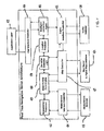
- FIG. 4 is a more detailed schematic of a navigation server 212 in accordance with one embodiment of the present invention.
- the configuration shown in Figure 4 is a different, but equivalent, description of the server than the configuration shown in Figure 3 .
- the user connects to the server 212 through the application layer 402.
- This application layer preferably translates user input into a form usable or preferred by the server 212.
- a subprocessor which is referred to as the User Interface Controller 404 in the preferred embodiment, controls interaction with the user, such as receiving information like user instructions or the user's destination, and conveying instructions, prompts, or other information to the user.
- This information is passed to and from a subprocessor, which is referred to as the Intelligent Instruction Agent 406 or User Interaction Engine in the preferred embodiment.
- This Intelligent Instruction Agent 406 receives information, such as the user's location and traffic information, from which it generates instructions to the user.
- a subprocessor which is referred to in the preferred embodiment as a Measurement Processor 412, receives measurement information from a controller component, referred to in the preferred embodiment as the Measurement Interface Controller 414.
- This measurement information may include various data regarding the location of the user, such as GPS, Cellular Digital Packetized Data (CDPD), U. S. Wireless (USW)(fingerprint technology), and @road (using CDPD company) information.
- the measurement information comprises the longitude and latitude of the user, obtained through GPS or similar capability.
- the Measurement Interface Controller receives measurement information from one or more Measurement Gateways 416. To perform these operations, the Measurement Processor 412 and/or the Measurement Controller 414 may receive information from the Intelligent Instruction Agent 406 including, for instance, information relating to the sampling rate for gathering measurement information, as discussed in more detail below.
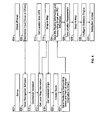
- Figure 6 generally shows a call flow for the operation of a method of providing navigational information in accordance with one embodiment of the present invention.
- the user After connecting with the server 602, the user, through a wireless telephone 604, PDA, or other appliance, provides a destination input 606 to the server 602.
- the user may have provided the destination information in advance, either through a wireless connection or through some other connection.
- the user's destination instruction is received by voice recognition software 608.
- the server After processing the user's input, the server provides destination validation 610.
- the server obtains local map information 612, as well as measurement information such as GPS information 614. This information is processed in the subprocessor referred to in the preferred embodiment as the Snap to Map processor 616, and/or other subprocessors, to determine the location of the user 618.
- the server then calculates a nominal route 620 for the user.
- This route information as well as surrounding street information and point of interest information, are then provided to the user 622.
- the information is also saved 624.
- the system again collects measurement information 626. That information is processed in the Snap to Map engine 628, and/or the intelligent guidance engine 630. Further instructions 632 are provided to the user, e.g., instructions regarding deviation from the nominal route.
- the call flow shown in Figure 6 is merely exemplary, and other variations may be within the scope of the present invention.
- the method shown in Figure 6 may also be used to provide the user with directions to a point of interest.
- the user may request directions to some other POI.
- This POI may take many forms, such as a specific address, a business name, a type of location, etc.
- the POI could be a specific location, e.g., "the office” or "Acme Bakery.”
- the POI could be a type of location, such as "gas station” or "police station.”
- the system If the POI is a specific location, the system generates navigational information to direct the user to the POI, and subsequently to the ultimate destination, using the methods and equipment described in this application.
- the core engine 450 identifies a subset of potential interim destinations, such as a group of gas stations along the user's route. Among that subset, the system provides the user with directions to one or more interim destinations.
- Figure 7 shows a schematic view of a call flow, in broad terms, of a method of providing navigational information in accordance with one embodiment of the present invention, in which the user is instructed or given the option to suspend the connection.
- This option may be given or taken for a number of reasons.
- Suspending the connection may conserve the battery or other power source of the user's appliance. If the user's connection is through a service for which the user is charged, suspending the connection can save the user money. In addition, suspending the call may conserve resources for the network(s) through which the connection is made, as well as the resources of the navigational server 212.
- the user will be unable to maintain the connection with the server at certain times during the user's trip due, for instance, to loss of connection with the user's wireless network, or lack of coverage in the user's area by the user's wireless carrier and/or its affiliates.
- the system may provide other programming to the user during these or other periods. For instance, the system may play music, advertisement, news, or other programming.
- the system may provide the user with selected or recorded information, including information pre-selected or pre-recorded by the user.
- the user enters in start mode 702.
- the system determines if action is needed, e.g., if it is time for the user to make a turn or take other action. If so, the system generates an action message for the user instructing the user to take the necessary action at step 706. The user then proceeds into nominal mode 720. If action is not needed at step 704, the system provides the user with a different message 708, such as a welcome message and/or a preparation message informing the user of upcoming action, e.g., "you will be turning left on Wolf road in 25 seconds.” The user then proceeds to nominal mode 720.
- a different message 708 such as a welcome message and/or a preparation message informing the user of upcoming action, e.g., "you will be turning left on Wolf road in 25 seconds.”
- the user may enter in resume mode 712. Again, the system, at step 714, determines if navigational action is needed. If so, the generates the action message instructing the user to take the necessary action at step 706, and the user proceeds to nominal mode 720. If not, the system provides the user with a different message 718, such as a resumption message and/or preparation message regarding upcoming navigational action, and the user proceeds to nominal mode 720.
- a different message 718 such as a resumption message and/or preparation message regarding upcoming navigational action
- Example 1 The method of Example 1, further comprising, after the step of re-establishing a real-time connection with the user, the step of determining if the user's previous trip was suspended.
- Example 1 The method of Example 1, further comprising, after the step of re-establishing a real-time connection with the user, the step of querying the user to determine if the user is resuming a suspended call.
- a system for providing location information to a user comprising:
- said user information further comprising the location of the user at the time the processor suspended interaction with the user.
- said storage device comprising a database of user information, said database comprising an indication of whether the user has suspended a call for a trip.
- a method for providing navigational information to a user comprising the steps of:
- Example 13 The method of Example 13, wherein the parameters needed to provide navigational information comprise the user's heading.
- a method for providing navigational information to a user comprising the steps of : obtaining the user's current location and ultimate destination; determining an initial preferred path from the user's current location to the ultimate destination; receiving an interim point of interest for the user through a connection to the user, said connection comprising a wireless telephone network; identifying potential interim destinations for the user, based at least in part on the user's point of interest and the geographic locations of related destinations; selecting an interim destination among the identified potential interim destinations, said selection based at least in part on the minimal deviation from the initial preferred path; and providing navigational information to the user, said navigational information comprising directions to the interim destination.
- Example 16 wherein said selected factors comprise the geographic environment in the vicinity of the user.
- Example 16 wherein said selected factors comprise the distance until the next expected navigational action for the user.
- Example 19 The method of Example 19, wherein said first format is a first language, and said second format is a second language.
- a method for providing navigational information to a user comprising the steps of:
Landscapes
- Engineering & Computer Science (AREA)
- Radar, Positioning & Navigation (AREA)
- Remote Sensing (AREA)
- Physics & Mathematics (AREA)
- General Physics & Mathematics (AREA)
- Automation & Control Theory (AREA)
- Business, Economics & Management (AREA)
- Human Resources & Organizations (AREA)
- Strategic Management (AREA)
- Computer Networks & Wireless Communication (AREA)
- Economics (AREA)
- Signal Processing (AREA)
- Mathematical Physics (AREA)
- Entrepreneurship & Innovation (AREA)
- Marketing (AREA)
- Operations Research (AREA)
- Quality & Reliability (AREA)
- Tourism & Hospitality (AREA)
- General Business, Economics & Management (AREA)
- Theoretical Computer Science (AREA)
- Development Economics (AREA)
- Game Theory and Decision Science (AREA)
- Navigation (AREA)
- Traffic Control Systems (AREA)
- Mobile Radio Communication Systems (AREA)
- Position Fixing By Use Of Radio Waves (AREA)
Applications Claiming Priority (2)
| Application Number | Priority Date | Filing Date | Title |
|---|---|---|---|
| US26416401P | 2001-01-24 | 2001-01-24 | |
| EP02706003A EP1364182B1 (fr) | 2001-01-24 | 2002-01-24 | Systeme de navigation en temps reel pour environnement mobile |
Related Parent Applications (1)
| Application Number | Title | Priority Date | Filing Date |
|---|---|---|---|
| EP02706003.7 Division | 2002-01-24 |
Publications (3)
| Publication Number | Publication Date |
|---|---|
| EP2365284A2 true EP2365284A2 (fr) | 2011-09-14 |
| EP2365284A3 EP2365284A3 (fr) | 2011-10-05 |
| EP2365284B1 EP2365284B1 (fr) | 2013-05-22 |
Family
ID=23004887
Family Applications (2)
| Application Number | Title | Priority Date | Filing Date |
|---|---|---|---|
| EP02706003A Expired - Lifetime EP1364182B1 (fr) | 2001-01-24 | 2002-01-24 | Systeme de navigation en temps reel pour environnement mobile |
| EP11166983.4A Expired - Lifetime EP2365284B1 (fr) | 2001-01-24 | 2002-01-24 | Procédé de navigation en temps réel pour un environnement mobile |
Family Applications Before (1)
| Application Number | Title | Priority Date | Filing Date |
|---|---|---|---|
| EP02706003A Expired - Lifetime EP1364182B1 (fr) | 2001-01-24 | 2002-01-24 | Systeme de navigation en temps reel pour environnement mobile |
Country Status (9)
| Country | Link |
|---|---|
| US (4) | US20020173905A1 (fr) |
| EP (2) | EP1364182B1 (fr) |
| KR (5) | KR20070054266A (fr) |
| CN (2) | CN1498335B (fr) |
| AT (1) | ATE542111T1 (fr) |
| AU (1) | AU2002240114A1 (fr) |
| CA (1) | CA2436012C (fr) |
| ES (2) | ES2377638T3 (fr) |
| WO (1) | WO2002060157A2 (fr) |
Cited By (1)
| Publication number | Priority date | Publication date | Assignee | Title |
|---|---|---|---|---|
| CN105043396A (zh) * | 2015-08-14 | 2015-11-11 | 北京进化者机器人科技有限公司 | 一种移动机器人室内自建地图的方法和系统 |
Families Citing this family (165)
| Publication number | Priority date | Publication date | Assignee | Title |
|---|---|---|---|---|
| US6714967B1 (en) | 1999-07-30 | 2004-03-30 | Microsoft Corporation | Integration of a computer-based message priority system with mobile electronic devices |
| US7194681B1 (en) | 1999-07-30 | 2007-03-20 | Microsoft Corporation | Method for automatically assigning priorities to documents and messages |
| US8073565B2 (en) * | 2000-06-07 | 2011-12-06 | Apple Inc. | System and method for alerting a first mobile data processing system nearby a second mobile data processing system |
| US20020173905A1 (en) * | 2001-01-24 | 2002-11-21 | Televigation, Inc. | Real-time navigation system for mobile environment |
| JP3961784B2 (ja) * | 2001-06-01 | 2007-08-22 | 株式会社エヌ・ティ・ティ・ドコモ | 測位装置、測位結果修正方法、プログラム及び記録媒体 |
| US8977284B2 (en) | 2001-10-04 | 2015-03-10 | Traxcell Technologies, LLC | Machine for providing a dynamic data base of geographic location information for a plurality of wireless devices and process for making same |
| US7283905B1 (en) | 2001-12-11 | 2007-10-16 | Garmin Ltd. | System and method for estimating impedance time through a road network |
| US6704645B1 (en) | 2001-12-11 | 2004-03-09 | Garmin Ltd. | System and method for estimating impedance time through a road network |
| US6581003B1 (en) | 2001-12-20 | 2003-06-17 | Garmin Ltd. | Systems and methods for a navigational device with forced layer switching based on memory constraints |
| US6545637B1 (en) | 2001-12-20 | 2003-04-08 | Garmin, Ltd. | Systems and methods for a navigational device with improved route calculation capabilities |
| US7184886B1 (en) | 2001-12-21 | 2007-02-27 | Garmin Ltd. | Navigation system, method and device with detour algorithm |
| US7277794B1 (en) | 2001-12-21 | 2007-10-02 | Garmin Ltd. | Guidance with feature accounting for insignificant roads |
| US6847890B1 (en) | 2001-12-21 | 2005-01-25 | Garmin Ltd. | Guidance with feature accounting for insignificant roads |
| US6859721B1 (en) * | 2001-12-21 | 2005-02-22 | Garmin Ltd. | System, device and method for providing proximate addresses |
| US6892135B1 (en) | 2001-12-21 | 2005-05-10 | Garmin Ltd. | Navigation system, method and device with automatic next turn page |
| FI114187B (fi) * | 2001-12-21 | 2004-08-31 | Nokia Corp | Opastuspalvelun järjestäminen langattoman päätelaitteen avulla |
| US6975940B1 (en) | 2001-12-21 | 2005-12-13 | Garmin Ltd. | Systems, functional data, and methods for generating a route |
| US6999873B1 (en) | 2001-12-21 | 2006-02-14 | Garmin Ltd. | Navigation system, method and device with detour algorithm |
| US7046827B2 (en) * | 2002-02-15 | 2006-05-16 | International Business Machines Corporation | Adapting point geometry for storing address density |
| KR100506220B1 (ko) * | 2002-02-27 | 2005-08-05 | 삼성전자주식회사 | 네비게이션 서비스를 위한 단일 경로 혹은 다중경로에서의 맵 매칭 장치 및 방법 |
| US20030217142A1 (en) | 2002-05-15 | 2003-11-20 | Microsoft Corporation | Method and system for supporting the communication of presence information regarding one or more telephony devices |
| US20030217098A1 (en) | 2002-05-15 | 2003-11-20 | Microsoft Corporation | Method and system for supporting the communication of presence information regarding one or more telephony devices |
| US6983155B1 (en) * | 2002-08-20 | 2006-01-03 | Sprint Communications Company L.P. | Providing geographic directions to a destination using a mobile wireless communication device |
| CA2495262C (fr) * | 2003-02-24 | 2009-11-17 | Harman Becker Automotive Systems Gmbh | Systeme de navigation avec information d'itineraire sonore |
| US20040220725A1 (en) * | 2003-03-21 | 2004-11-04 | Cheng Steven D | Method and apparatus for avoiding route deviation |
| US20050102098A1 (en) * | 2003-11-07 | 2005-05-12 | Montealegre Steve E. | Adaptive navigation system with artificial intelligence |
| US20050134504A1 (en) * | 2003-12-22 | 2005-06-23 | Lear Corporation | Vehicle appliance having hands-free telephone, global positioning system, and satellite communications modules combined in a common architecture for providing complete telematics functions |
| US7934012B2 (en) * | 2004-03-12 | 2011-04-26 | Sap Ag | Automatic translation code generation |
| JPWO2005109933A1 (ja) * | 2004-05-06 | 2008-03-21 | 三菱電機株式会社 | 移動体端末及びサーバ及び情報提供システム及び移動体端末の通信方法及びサーバの通信方法及び情報提供システムの情報提供方法 |
| US20050261828A1 (en) * | 2004-05-18 | 2005-11-24 | Crowder George E Jr | Device and method for energy-minimizing human ground routing |
| US20060031903A1 (en) * | 2004-07-30 | 2006-02-09 | Pulitzer J H | Emergency call source locator on an A/V telecommunication system |
| US8046213B2 (en) * | 2004-08-06 | 2011-10-25 | Nuance Communications, Inc. | On demand TTS vocabulary for a telematics system |
| US20060047400A1 (en) * | 2004-08-25 | 2006-03-02 | Raj Prakash | Method and apparatus for braking and stopping vehicles having an electric drive |
| US10645562B2 (en) | 2004-09-21 | 2020-05-05 | Agis Software Development Llc | Method to provide ad hoc and password protected digital and voice networks |
| US7480567B2 (en) * | 2004-09-24 | 2009-01-20 | Nokia Corporation | Displaying a map having a close known location |
| KR100713465B1 (ko) * | 2005-01-25 | 2007-05-02 | 삼성전자주식회사 | 네비게이션 시스템에서 경로 계산 방법 |
| JP2006237735A (ja) * | 2005-02-22 | 2006-09-07 | Denso Corp | 車両用ナビゲーション装置 |
| US7353034B2 (en) | 2005-04-04 | 2008-04-01 | X One, Inc. | Location sharing and tracking using mobile phones or other wireless devices |
| US20070050128A1 (en) * | 2005-08-31 | 2007-03-01 | Garmin Ltd., A Cayman Islands Corporation | Method and system for off-board navigation with a portable device |
| US7634354B2 (en) * | 2005-08-31 | 2009-12-15 | Microsoft Corporation | Location signposting and orientation |
| US20070078596A1 (en) | 2005-09-30 | 2007-04-05 | John Grace | Landmark enhanced directions |
| US8731585B2 (en) | 2006-02-10 | 2014-05-20 | Telecommunications Systems, Inc. | Intelligent reverse geocoding |
| US7899468B2 (en) * | 2005-09-30 | 2011-03-01 | Telecommunication Systems, Inc. | Location sensitive messaging |
| US8437958B2 (en) | 2005-11-14 | 2013-05-07 | General Motors Llc | Method and system for providing wireless connection conditions along a navigation route |
| US20070118284A1 (en) * | 2005-11-23 | 2007-05-24 | Sbc Knowledge Ventures, L.P. | Customized GPS provisioning |
| KR100725792B1 (ko) * | 2006-02-01 | 2007-06-08 | 엔에이치엔(주) | 개인 웹페이지에서의 지리 정보 제공 방법 및 시스템 |
| US7649534B2 (en) * | 2006-02-01 | 2010-01-19 | Microsoft Corporation | Design of arbitrary linear and non-linear maps |
| US8306556B2 (en) * | 2006-02-08 | 2012-11-06 | Telenav, Inc. | Intelligent real-time distributed traffic sampling and navigation system |
| WO2007102367A1 (fr) * | 2006-02-28 | 2007-09-13 | Toyota Jidosha Kabushiki Kaisha | Procede de prediction de trajet d'objet, dispositif, programme et systeme de pilotage automatique |
| US7539562B2 (en) | 2006-03-06 | 2009-05-26 | Gm Global Technology Operations, Inc. | Hybrid vehicle powertrain control method and apparatus |
| US7925320B2 (en) | 2006-03-06 | 2011-04-12 | Garmin Switzerland Gmbh | Electronic device mount |
| US8208949B2 (en) * | 2006-03-16 | 2012-06-26 | Marc Stuart Cox | Navigation system for portable communication devices |
| CN100591016C (zh) * | 2006-03-17 | 2010-02-17 | 华为技术有限公司 | 一种动态内容续传方法及系统 |
| US7526294B2 (en) * | 2006-03-23 | 2009-04-28 | Alcatel-Lucent Usa Inc. | Point-of-sale gas pump with access to travel information service |
| US20070281680A1 (en) * | 2006-06-05 | 2007-12-06 | Vish Raju | Method and system for extending services to cellular devices |
| US20080004926A1 (en) * | 2006-06-30 | 2008-01-03 | Microsoft Corporation | Methods and architectures for context-sensitive reminders and service facilitation |
| US7957751B2 (en) | 2006-08-02 | 2011-06-07 | Telecommunication Systems, Inc. | Personal location code |
| US8874145B2 (en) * | 2006-08-02 | 2014-10-28 | Telecommunication Systems, Inc. | Personal location code broker |
| US8134481B2 (en) * | 2006-08-11 | 2012-03-13 | Honda Motor Co., Ltd. | Method and system for receiving and sending navigational data via a wireless messaging service on a navigation system |
| US7571048B2 (en) * | 2006-08-18 | 2009-08-04 | Google Inc. | Providing routing information based on ambiguous locations |
| NZ549547A (en) * | 2006-08-31 | 2008-12-24 | Trekwizard Ltd | Methods and apparatus of grading a route and calculating travel time information for the route |
| US8155157B2 (en) * | 2006-09-22 | 2012-04-10 | Samsung Electronics Co., Ltd. | Method and apparatus for synchronizing applications of terminals in communication network |
| US7595738B2 (en) * | 2006-10-26 | 2009-09-29 | Alcatel-Lucent Usa Inc. | Method and apparatus for emergency map display system |
| TWI343213B (en) * | 2006-11-08 | 2011-06-01 | Qisda Corp | Method for playing audio-video file and playing system using the same |
| US20080154761A1 (en) * | 2006-12-20 | 2008-06-26 | Microsoft Corporation | Commoditization of products and product market |
| US20080154719A1 (en) * | 2006-12-20 | 2008-06-26 | Microsoft Corporation | Market sharing incentives |
| US20080154915A1 (en) * | 2006-12-20 | 2008-06-26 | Microsoft Corporation | Network-based recommendations |
| US8271310B2 (en) * | 2006-12-20 | 2012-09-18 | Microsoft Corporation | Virtualizing consumer behavior as a financial instrument |
| US8799077B2 (en) * | 2006-12-20 | 2014-08-05 | Microsoft Corporation | Ad integration and extensible themes for operating systems |
| US8112770B2 (en) | 2006-12-20 | 2012-02-07 | Microsoft Corporation | Providing alternative content in a windowed environment |
| US20080154698A1 (en) * | 2006-12-20 | 2008-06-26 | Microsoft Corporation | Dyanmic product classification for opinion aggregation |
| US7848880B2 (en) * | 2007-02-28 | 2010-12-07 | Microsoft Corporation | Traffic information adaptive to a user's travel |
| US7848876B2 (en) * | 2007-03-20 | 2010-12-07 | Ford Motor Company | System and method for determining a vehicle traffic route |
| US8229458B2 (en) | 2007-04-08 | 2012-07-24 | Enhanced Geographic Llc | Systems and methods to determine the name of a location visited by a user of a wireless device |
| US8345043B2 (en) * | 2007-04-13 | 2013-01-01 | Autodesk, Inc. | Solving networks of geometric constraints |
| KR100858152B1 (ko) * | 2007-05-30 | 2008-09-10 | 주식회사 케이티프리텔 | 글로벌 네비게이션 서비스 장치 및 방법 |
| US20080319660A1 (en) * | 2007-06-25 | 2008-12-25 | Microsoft Corporation | Landmark-based routing |
| US20080319658A1 (en) * | 2007-06-25 | 2008-12-25 | Microsoft Corporation | Landmark-based routing |
| US7912637B2 (en) * | 2007-06-25 | 2011-03-22 | Microsoft Corporation | Landmark-based routing |
| US8311526B2 (en) | 2007-06-28 | 2012-11-13 | Apple Inc. | Location-based categorical information services |
| US8175802B2 (en) * | 2007-06-28 | 2012-05-08 | Apple Inc. | Adaptive route guidance based on preferences |
| US8290513B2 (en) | 2007-06-28 | 2012-10-16 | Apple Inc. | Location-based services |
| US8762056B2 (en) | 2007-06-28 | 2014-06-24 | Apple Inc. | Route reference |
| US8332402B2 (en) | 2007-06-28 | 2012-12-11 | Apple Inc. | Location based media items |
| US9066199B2 (en) | 2007-06-28 | 2015-06-23 | Apple Inc. | Location-aware mobile device |
| US8180379B2 (en) | 2007-06-28 | 2012-05-15 | Apple Inc. | Synchronizing mobile and vehicle devices |
| US9109904B2 (en) | 2007-06-28 | 2015-08-18 | Apple Inc. | Integration of map services and user applications in a mobile device |
| US8774825B2 (en) | 2007-06-28 | 2014-07-08 | Apple Inc. | Integration of map services with user applications in a mobile device |
| US8108144B2 (en) | 2007-06-28 | 2012-01-31 | Apple Inc. | Location based tracking |
| US8385946B2 (en) | 2007-06-28 | 2013-02-26 | Apple Inc. | Disfavored route progressions or locations |
| US8275352B2 (en) | 2007-06-28 | 2012-09-25 | Apple Inc. | Location-based emergency information |
| US8204684B2 (en) * | 2007-06-28 | 2012-06-19 | Apple Inc. | Adaptive mobile device navigation |
| US8271188B2 (en) * | 2007-06-29 | 2012-09-18 | Octaview Technologies B.V. | Systems and methods for determining location using cellular transition patterns |
| US8589563B2 (en) * | 2007-07-10 | 2013-11-19 | Cisco Technology, Inc. | System, method, and apparatus for maintaining call state information for real-time call sessions |
| US20090070840A1 (en) * | 2007-09-05 | 2009-03-12 | Hitachi, Ltd. | Terminal-Cooperated System, Terminal, Server and Method for Uninterrupted Reception of Contents |
| US8977294B2 (en) | 2007-10-10 | 2015-03-10 | Apple Inc. | Securely locating a device |
| US8155877B2 (en) * | 2007-11-29 | 2012-04-10 | Microsoft Corporation | Location-to-landmark |
| US20090143125A1 (en) * | 2007-11-29 | 2009-06-04 | Microsoft Corporation | Population of landmarks for use with a map application |
| CN101451843A (zh) * | 2007-11-30 | 2009-06-10 | 鸿富锦精密工业(深圳)有限公司 | 便携式电子装置及其行程时间计算方法 |
| CN101458088A (zh) * | 2007-12-14 | 2009-06-17 | 鸿富锦精密工业(深圳)有限公司 | 便携式电子装置及其交通信息查询方法 |
| US9341494B2 (en) * | 2007-12-21 | 2016-05-17 | Nokia Technologies Oy | Apparatuses and methods for managing route navigation via mobile devices |
| US20090171556A1 (en) * | 2007-12-31 | 2009-07-02 | Telenav, Inc. | Mutable Mobile Traffic Routing System |
| US8355862B2 (en) | 2008-01-06 | 2013-01-15 | Apple Inc. | Graphical user interface for presenting location information |
| US8819741B2 (en) | 2008-04-03 | 2014-08-26 | Microsoft Corporation | Streaming video over a wireless network |
| CN102016500B (zh) * | 2008-04-28 | 2012-09-26 | 株式会社纳维泰 | 路径向导系统、路径检索服务器、路径向导方法及终端装置 |
| US9250092B2 (en) | 2008-05-12 | 2016-02-02 | Apple Inc. | Map service with network-based query for search |
| US8644843B2 (en) | 2008-05-16 | 2014-02-04 | Apple Inc. | Location determination |
| US8533606B2 (en) * | 2008-06-13 | 2013-09-10 | At&T Intellectual Property I, L.P. | System and method for personalized hold |
| US8700301B2 (en) | 2008-06-19 | 2014-04-15 | Microsoft Corporation | Mobile computing devices, architecture and user interfaces based on dynamic direction information |
| US20090315766A1 (en) * | 2008-06-19 | 2009-12-24 | Microsoft Corporation | Source switching for devices supporting dynamic direction information |
| US8467991B2 (en) | 2008-06-20 | 2013-06-18 | Microsoft Corporation | Data services based on gesture and location information of device |
| US8369867B2 (en) | 2008-06-30 | 2013-02-05 | Apple Inc. | Location sharing |
| US20100070161A1 (en) * | 2008-09-14 | 2010-03-18 | Harris Scott C | Multimode Navigator device |
| US8359643B2 (en) | 2008-09-18 | 2013-01-22 | Apple Inc. | Group formation using anonymous broadcast information |
| US8260320B2 (en) | 2008-11-13 | 2012-09-04 | Apple Inc. | Location specific content |
| US8219316B2 (en) | 2008-11-14 | 2012-07-10 | Google Inc. | System and method for storing and providing routes |
| US20100228476A1 (en) * | 2009-03-04 | 2010-09-09 | Microsoft Corporation | Path projection to facilitate engagement |
| US8494215B2 (en) | 2009-03-05 | 2013-07-23 | Microsoft Corporation | Augmenting a field of view in connection with vision-tracking |
| US10149982B2 (en) | 2009-03-11 | 2018-12-11 | University Of South Florida | Prevention and treatment of brain diseases and disorders related to abnormal protein aggregation through electromagnetic field treatment |
| WO2010105035A2 (fr) | 2009-03-11 | 2010-09-16 | University Of South Florida | Prévention, traitement, et diagnostic de la maladie d'alzheimer par exposition à un champ électromagnétique |
| CA2756183A1 (fr) * | 2009-03-30 | 2010-10-07 | Aha Mobile, Inc. | Recherche predictive avec application fondee sur une position |
| US20100268460A1 (en) * | 2009-04-15 | 2010-10-21 | Telenav, Inc. | Navigation system with predictive multi-routing and method of operation thereof |
| US8666367B2 (en) | 2009-05-01 | 2014-03-04 | Apple Inc. | Remotely locating and commanding a mobile device |
| US8660530B2 (en) | 2009-05-01 | 2014-02-25 | Apple Inc. | Remotely receiving and communicating commands to a mobile device for execution by the mobile device |
| US8670748B2 (en) | 2009-05-01 | 2014-03-11 | Apple Inc. | Remotely locating and commanding a mobile device |
| US8872767B2 (en) | 2009-07-07 | 2014-10-28 | Microsoft Corporation | System and method for converting gestures into digital graffiti |
| US8233919B2 (en) * | 2009-08-09 | 2012-07-31 | Hntb Holdings Ltd. | Intelligently providing user-specific transportation-related information |
| US8352178B2 (en) | 2009-08-25 | 2013-01-08 | Research In Motion Limited | Method and device for generating and communicating geographic route information between wireless communication devices |
| US8442767B2 (en) * | 2009-08-28 | 2013-05-14 | Navteq B.V. | Method of operating a navigation system to provide route guidance |
| US8301641B2 (en) * | 2009-08-28 | 2012-10-30 | Navteq B.V. | Method of collecting information for a geographic database for use with a navigation system |
| US8364398B2 (en) * | 2009-08-28 | 2013-01-29 | Navteq B.V. | Method of operating a navigation system to provide route guidance |
| US8370060B2 (en) * | 2009-08-28 | 2013-02-05 | Navteq B.V. | Method of operating a navigation system to provide route guidance |
| US8543326B2 (en) * | 2009-09-29 | 2013-09-24 | Telenav, Inc. | Navigation system with orientation mechanism and method of operation thereof |
| US8374791B2 (en) * | 2010-01-27 | 2013-02-12 | Navteq B.V. | Method of operating a navigation system to provide route guidance |
| US8305264B1 (en) | 2010-02-03 | 2012-11-06 | Sprint Spectrum L.P. | GPS enhancement for wireless devices |
| US20120109505A1 (en) * | 2010-11-02 | 2012-05-03 | Research In Motion Limited | Traffic information based on trusted group behaviour |
| US9541411B2 (en) * | 2010-11-20 | 2017-01-10 | Telenav, Inc. | Navigation system with destination travel category extraction measurement capture mechanism and method of operation thereof |
| US9880014B2 (en) * | 2010-11-24 | 2018-01-30 | Telenav, Inc. | Navigation system with session transfer mechanism and method of operation thereof |
| US10467649B2 (en) * | 2010-12-02 | 2019-11-05 | Telenav, Inc. | Advertisement delivery system with destination-centric advertisement delivery mechanism and method of operation thereof |
| US9589254B2 (en) | 2010-12-08 | 2017-03-07 | Microsoft Technology Licensing, Llc | Using e-mail message characteristics for prioritization |
| US9134137B2 (en) | 2010-12-17 | 2015-09-15 | Microsoft Technology Licensing, Llc | Mobile search based on predicted location |
| JP5584107B2 (ja) * | 2010-12-21 | 2014-09-03 | アイシン・エィ・ダブリュ株式会社 | ナビゲーション装置、ナビゲーション方法、およびプログラム |
| US9163952B2 (en) | 2011-04-15 | 2015-10-20 | Microsoft Technology Licensing, Llc | Suggestive mapping |
| CN102802117A (zh) * | 2011-05-27 | 2012-11-28 | 国际商业机器公司 | 用于提供基于位置的交通信息服务的方法、设备和服务站 |
| CN108415412A (zh) * | 2011-08-29 | 2018-08-17 | 克朗设备公司 | 车辆导航控制接口 |
| WO2013094865A1 (fr) * | 2011-12-18 | 2013-06-27 | 엘지전자 주식회사 | Procédé de calcul de trajets, procédé d'obtention de trajets ainsi que terminal pour celui-ci |
| US9510171B1 (en) | 2012-03-22 | 2016-11-29 | Sprint Spectrum L.P. | Provisioning mobile station with destination communication address during de-registration |
| US9298358B1 (en) * | 2012-08-21 | 2016-03-29 | Google Inc. | Scrollable notifications |
| WO2014066562A2 (fr) * | 2012-10-25 | 2014-05-01 | Intel Corporation | Optimisation d'itinéraire comprenant des points d'intérêt |
| US9383216B2 (en) * | 2012-10-31 | 2016-07-05 | International Business Machines Corporation | Providing online mapping with user selected preferences |
| US9264860B2 (en) | 2013-03-14 | 2016-02-16 | Samsung Electronics Co., Ltd. | Communication system with indoor navigation mechanism and method of operation thereof |
| CN104376009B (zh) * | 2013-08-14 | 2019-11-05 | 腾讯科技(深圳)有限公司 | 微博页面的丰富化方法、系统和装置 |
| US9779449B2 (en) * | 2013-08-30 | 2017-10-03 | Spireon, Inc. | Veracity determination through comparison of a geospatial location of a vehicle with a provided data |
| US9210621B1 (en) | 2013-09-23 | 2015-12-08 | Sprint Spectrum L.P. | Method and system for facilitating service level continuity |
| US9726511B2 (en) | 2013-11-12 | 2017-08-08 | Telenav, Inc. | Navigation system with destination selection mechanism and method of operation thereof |
| WO2015125516A1 (fr) * | 2014-02-20 | 2015-08-27 | アイシン・エィ・ダブリュ株式会社 | Système, procédé et programme de notification d'avertissement |
| KR102089511B1 (ko) * | 2015-01-27 | 2020-04-16 | 한국전자통신연구원 | 단말의 보안 접속 제어 방법 및 그에 따른 장치 |
| US10198192B2 (en) * | 2015-03-31 | 2019-02-05 | Veritas Technologies Llc | Systems and methods for improving quality of service within hybrid storage systems |
| TWI593940B (zh) * | 2016-03-22 | 2017-08-01 | 群邁通訊股份有限公司 | 通訊導航方法及電子裝置 |
| US10114373B2 (en) * | 2016-05-17 | 2018-10-30 | Telenav, Inc. | Navigation system with trajectory calculation mechanism and method of operation thereof |
| US10746559B2 (en) | 2016-08-15 | 2020-08-18 | International Business Machines Corporation | Dynamic route guidance based on real-time data |
| EP3837493B1 (fr) * | 2019-08-12 | 2024-07-24 | Google LLC | Utilisation d'une intensité de signal radiofréquence pour améliorer des options d'itinéraire dans un service de navigation |
| US11770682B2 (en) * | 2021-08-17 | 2023-09-26 | Allstate Insurance Company | Vehicle commute location patterns based on user location data |
| CN117367443A (zh) * | 2022-06-30 | 2024-01-09 | 华人运通(上海)云计算科技有限公司 | 导航方法及装置、电子设备及存储介质 |
| CN118190003B (zh) * | 2024-03-20 | 2025-04-04 | 宁冬桂 | 基于规划路径数据的语音识别导航方法 |
Family Cites Families (66)
| Publication number | Priority date | Publication date | Assignee | Title |
|---|---|---|---|---|
| JPH0613976B2 (ja) * | 1985-12-17 | 1994-02-23 | マツダ株式会社 | 車両用走行誘導装置 |
| US4953204A (en) * | 1989-10-17 | 1990-08-28 | At&T Bell Laboratories | Multilocation queuing for telephone calls |
| US5956250A (en) * | 1990-02-05 | 1999-09-21 | Caterpillar Inc. | Apparatus and method for autonomous vehicle navigation using absolute data |
| JP2857490B2 (ja) * | 1990-11-21 | 1999-02-17 | 株式会社日立製作所 | 学習機能をもつ地図システム |
| US5579535A (en) * | 1991-07-01 | 1996-11-26 | Motorola, Inc. | Personal communication system providing supplemental information mode |
| US5608635A (en) * | 1992-04-14 | 1997-03-04 | Zexel Corporation | Navigation system for a vehicle with route recalculation between multiple locations |
| EP0580166B1 (fr) * | 1992-07-23 | 1999-06-16 | Aisin Aw Co., Ltd. | Système de navigation pour les véhicules |
| US5412573A (en) * | 1993-05-20 | 1995-05-02 | Motorola Inc. | Multi-mode route guidance system and method therefor |
| US6175806B1 (en) * | 1993-07-16 | 2001-01-16 | Caterpillar Inc. | Method and apparatus for detecting cycle slips in navigation signals received at a receiver from a satellite-based navigation system |
| US6580904B2 (en) * | 1994-04-28 | 2003-06-17 | Metro One Telecommunications, Inc. | Method of providing directional assistance to a mobile telephone subscriber |
| CA2129302C (fr) * | 1994-04-28 | 2002-04-09 | Patrick Michael Cox | Technique pour retourner a l'assistance-annuaire ou aux pourvoyeurs de services d'informations lorsque demande |
| US5543789A (en) * | 1994-06-24 | 1996-08-06 | Shields Enterprises, Inc. | Computerized navigation system |
| JP3365054B2 (ja) * | 1994-06-29 | 2003-01-08 | カシオ計算機株式会社 | 位置情報送信システムおよびそれに用いられる位置情報管理装置 |
| DE4429322A1 (de) | 1994-08-18 | 1996-02-22 | Bayerische Motoren Werke Ag | Navigationsverfahren für Kraftfahrzeuge |
| US5528248A (en) * | 1994-08-19 | 1996-06-18 | Trimble Navigation, Ltd. | Personal digital location assistant including a memory cartridge, a GPS smart antenna and a personal computing device |
| US5610821A (en) * | 1994-11-18 | 1997-03-11 | Ibm Corporation | Optimal and stable route planning system |
| US5938720A (en) * | 1995-02-09 | 1999-08-17 | Visteon Technologies, Llc | Route generation in a vehicle navigation system |
| AU5001096A (en) * | 1995-04-06 | 1996-10-23 | Detemobil Deutsche Telekom Mobilnet Gmbh | Process for a vehicle control and information system |
| US5774828A (en) * | 1995-04-07 | 1998-06-30 | Delco Electronics Corporation | Mapless GPS navigation system with user modifiable data base |
| US5742509A (en) * | 1995-04-11 | 1998-04-21 | Trimble Navigation Limited | Personal tracking system integrated with base station |
| US6208295B1 (en) * | 1995-06-02 | 2001-03-27 | Trw Inc. | Method for processing radio signals that are subject to unwanted change during propagation |
| US5825306A (en) | 1995-08-25 | 1998-10-20 | Aisin Aw Co., Ltd. | Navigation system for vehicles |
| US5898390A (en) | 1995-09-14 | 1999-04-27 | Zexel Corporation | Method and apparatus for calibration of a distance sensor in a vehicle navigation system |
| KR100235239B1 (ko) * | 1995-09-29 | 1999-12-15 | 모리 하루오 | 가형정보의 출력장치, 가형정보의 출력방법, 지도표시장치, 지도표시방법, 네비게이션장치 및 네비게이션방법 |
| US5699255A (en) * | 1995-10-18 | 1997-12-16 | Trimble Navigation Limited | Map transmission for in-vehicle navigation system with dynamic scale/detail adjustment |
| DE19539641C2 (de) * | 1995-10-25 | 2000-02-17 | Daimler Chrysler Ag | Verfahren und Einrichtung zur verkehrssituationsabhängigen Fahrzeugzielführung |
| US5774829A (en) * | 1995-12-12 | 1998-06-30 | Pinterra Corporation | Navigation and positioning system and method using uncoordinated beacon signals in conjunction with an absolute positioning system |
| US5933100A (en) * | 1995-12-27 | 1999-08-03 | Mitsubishi Electric Information Technology Center America, Inc. | Automobile navigation system with dynamic traffic data |
| US5835881A (en) * | 1996-01-16 | 1998-11-10 | Philips Electronics North America Corporation | Portable system for providing voice driving directions |
| FI102868B (fi) * | 1996-02-26 | 1999-02-26 | Nokia Mobile Phones Ltd | Päätelaite tietoliikennepalvelun käyttämiseksi |
| DE19621424A1 (de) | 1996-05-28 | 1997-12-04 | Telemedia Gmbh | Verfahren und Vorrichtung zum Selektieren von Abfragedaten aus einer gespeicherten Datenmenge in Abhängigkeit von der geographischen Momentanposition des Benutzers |
| JP2910674B2 (ja) | 1996-05-28 | 1999-06-23 | 日本電気株式会社 | 音声による携帯電話のナビゲーションシステム |
| US5901214A (en) * | 1996-06-10 | 1999-05-04 | Murex Securities, Ltd. | One number intelligent call processing system |
| US6199045B1 (en) * | 1996-08-15 | 2001-03-06 | Spatial Adventures, Inc. | Method and apparatus for providing position-related information to mobile recipients |
| US5922042A (en) * | 1996-09-30 | 1999-07-13 | Visteon Technologies, Llc | Automatic resumption of route guidance in vehicle navigation system |
| US5904728A (en) * | 1996-10-11 | 1999-05-18 | Visteon Technologies, Llc | Voice guidance timing in a vehicle navigation system |
| US5938721A (en) * | 1996-10-24 | 1999-08-17 | Trimble Navigation Limited | Position based personal digital assistant |
| US5902350A (en) * | 1996-10-30 | 1999-05-11 | Visteon Technologies, Llc | Generating a maneuver at the intersection through a turn lane |
| US5910177A (en) * | 1996-12-09 | 1999-06-08 | Visteon Technologies, Llc | Navigating close proximity routes with a vehicle navigation system |
| US5928295A (en) * | 1996-12-16 | 1999-07-27 | Motorola, Inc. | Method and apparatus for automatic calibration of the wheel track of a movable vehicle |
| US5928307A (en) * | 1997-01-15 | 1999-07-27 | Visteon Technologies, Llc | Method and apparatus for determining an alternate route in a vehicle navigation system |
| US6115700A (en) * | 1997-01-31 | 2000-09-05 | The United States Of America As Represented By The Secretary Of The Navy | System and method for tracking vehicles using random search algorithms |
| US5987381A (en) * | 1997-03-11 | 1999-11-16 | Visteon Technologies, Llc | Automobile navigation system using remote download of data |
| FR2761837B1 (fr) | 1997-04-08 | 1999-06-11 | Sophie Sommelet | Dispositif d'aide a la navigation ayant une architecture distribuee basee sur internet |
| US6021371A (en) * | 1997-04-16 | 2000-02-01 | Trimble Navigation Limited | Communication and navigation system incorporating position determination |
| JP3769878B2 (ja) | 1997-05-23 | 2006-04-26 | 株式会社エクォス・リサーチ | ナビゲーション装置 |
| US6148261A (en) * | 1997-06-20 | 2000-11-14 | American Calcar, Inc. | Personal communication system to send and receive voice data positioning information |
| US6055478A (en) * | 1997-10-30 | 2000-04-25 | Sony Corporation | Integrated vehicle navigation, communications and entertainment system |
| US6088594A (en) * | 1997-11-26 | 2000-07-11 | Ericsson Inc. | System and method for positioning a mobile terminal using a terminal based browser |
| US6014090A (en) * | 1997-12-22 | 2000-01-11 | At&T Corp. | Method and apparatus for delivering local information to travelers |
| US6243657B1 (en) * | 1997-12-23 | 2001-06-05 | Pii North America, Inc. | Method and apparatus for determining location of characteristics of a pipeline |
| CN1229926A (zh) * | 1998-03-19 | 1999-09-29 | 蒋建平 | 卫星定位移动通讯车辆跟踪系统 |
| JPH11304518A (ja) | 1998-04-22 | 1999-11-05 | Sanyo Electric Co Ltd | ナビゲーション装置 |
| DE19821750A1 (de) | 1998-05-14 | 1999-12-02 | Nokia Mobile Phones Ltd | Verfahren zum Eingeben von Positionsdaten in ein Straßen-Informationsdienstsystem |
| US6539080B1 (en) * | 1998-07-14 | 2003-03-25 | Ameritech Corporation | Method and system for providing quick directions |
| US6205400B1 (en) * | 1998-11-27 | 2001-03-20 | Ching-Fang Lin | Vehicle positioning and data integrating method and system thereof |
| US6154658A (en) * | 1998-12-14 | 2000-11-28 | Lockheed Martin Corporation | Vehicle information and safety control system |
| US6175807B1 (en) * | 1999-06-09 | 2001-01-16 | Litton Systems, Inc. | Temperature compensation method for strapdown inertial navigation systems |
| US6321161B1 (en) * | 1999-09-09 | 2001-11-20 | Navigation Technologies Corporation | Method and system for providing guidance about alternative routes with a navigation system |
| US6266615B1 (en) * | 1999-09-27 | 2001-07-24 | Televigation, Inc. | Method and system for an interactive and real-time distributed navigation system |
| US6405123B1 (en) * | 1999-12-21 | 2002-06-11 | Televigation, Inc. | Method and system for an efficient operating environment in a real-time navigation system |
| US6510381B2 (en) * | 2000-02-11 | 2003-01-21 | Thomas L. Grounds | Vehicle mounted device and a method for transmitting vehicle position data to a network-based server |
| US6269306B1 (en) * | 2000-06-13 | 2001-07-31 | Ford Global Tech. | System and method for estimating sensor errors |
| US6501956B1 (en) * | 2000-10-17 | 2002-12-31 | Intervoice Limited Partnership | Providing blended interface for wireless information services |
| US20020151327A1 (en) * | 2000-12-22 | 2002-10-17 | David Levitt | Program selector and guide system and method |
| US20020173905A1 (en) * | 2001-01-24 | 2002-11-21 | Televigation, Inc. | Real-time navigation system for mobile environment |
-
2002
- 2002-01-24 US US10/057,236 patent/US20020173905A1/en not_active Abandoned
- 2002-01-24 AU AU2002240114A patent/AU2002240114A1/en not_active Abandoned
- 2002-01-24 CN CN028067606A patent/CN1498335B/zh not_active Expired - Lifetime
- 2002-01-24 KR KR1020077010857A patent/KR20070054266A/ko not_active Ceased
- 2002-01-24 WO PCT/US2002/002323 patent/WO2002060157A2/fr not_active Ceased
- 2002-01-24 ES ES02706003T patent/ES2377638T3/es not_active Expired - Lifetime
- 2002-01-24 KR KR1020077010856A patent/KR20070054757A/ko not_active Ceased
- 2002-01-24 KR KR1020077010858A patent/KR20070054758A/ko not_active Ceased
- 2002-01-24 CA CA002436012A patent/CA2436012C/fr not_active Expired - Lifetime
- 2002-01-24 EP EP02706003A patent/EP1364182B1/fr not_active Expired - Lifetime
- 2002-01-24 CN CN201010162043.1A patent/CN101839723B/zh not_active Expired - Lifetime
- 2002-01-24 EP EP11166983.4A patent/EP2365284B1/fr not_active Expired - Lifetime
- 2002-01-24 KR KR10-2003-7009828A patent/KR20030085128A/ko not_active Ceased
- 2002-01-24 KR KR1020077010861A patent/KR20070054759A/ko not_active Ceased
- 2002-01-24 AT AT02706003T patent/ATE542111T1/de active
- 2002-01-24 ES ES11166983T patent/ES2421258T3/es not_active Expired - Lifetime
-
2003
- 2003-11-14 US US10/714,527 patent/US7389179B2/en not_active Expired - Lifetime
-
2007
- 2007-09-13 US US11/901,220 patent/US20080052105A1/en not_active Abandoned
-
2013
- 2013-08-14 US US13/966,787 patent/US20140005920A1/en not_active Abandoned
Cited By (2)
| Publication number | Priority date | Publication date | Assignee | Title |
|---|---|---|---|---|
| CN105043396A (zh) * | 2015-08-14 | 2015-11-11 | 北京进化者机器人科技有限公司 | 一种移动机器人室内自建地图的方法和系统 |
| CN105043396B (zh) * | 2015-08-14 | 2018-02-02 | 北京进化者机器人科技有限公司 | 一种移动机器人室内自建地图的方法和系统 |
Also Published As
| Publication number | Publication date |
|---|---|
| WO2002060157A3 (fr) | 2003-05-22 |
| US7389179B2 (en) | 2008-06-17 |
| KR20070054266A (ko) | 2007-05-28 |
| KR20030085128A (ko) | 2003-11-03 |
| AU2002240114A1 (en) | 2002-08-06 |
| EP2365284A3 (fr) | 2011-10-05 |
| US20040220726A1 (en) | 2004-11-04 |
| US20020173905A1 (en) | 2002-11-21 |
| KR20070054757A (ko) | 2007-05-29 |
| CA2436012A1 (fr) | 2002-08-01 |
| ATE542111T1 (de) | 2012-02-15 |
| CN1498335A (zh) | 2004-05-19 |
| CN101839723B (zh) | 2015-02-18 |
| ES2377638T3 (es) | 2012-03-29 |
| CN1498335B (zh) | 2012-01-11 |
| KR20070054758A (ko) | 2007-05-29 |
| KR20070054759A (ko) | 2007-05-29 |
| US20140005920A1 (en) | 2014-01-02 |
| ES2421258T3 (es) | 2013-08-30 |
| CN101839723A (zh) | 2010-09-22 |
| EP2365284B1 (fr) | 2013-05-22 |
| WO2002060157A2 (fr) | 2002-08-01 |
| EP1364182A2 (fr) | 2003-11-26 |
| US20080052105A1 (en) | 2008-02-28 |
| CA2436012C (fr) | 2009-04-28 |
| EP1364182B1 (fr) | 2012-01-18 |
| HK1066272A1 (en) | 2005-03-18 |
| EP1364182A4 (fr) | 2008-11-12 |
Similar Documents
| Publication | Publication Date | Title |
|---|---|---|
| CA2436012C (fr) | Systeme de navigation en temps reel pour environnement mobile | |
| KR20060090289A (ko) | 도착 시간을 추정하는 시스템 및 방법 | |
| US6807483B1 (en) | Method and system for prediction-based distributed navigation | |
| EP2394138B1 (fr) | Système de navigation ayant une couverture adaptative et son procédé de fonctionnement | |
| CA2583458C (fr) | Procede et systeme permettant d'activer une solution de navigation non yransportee | |
| US6845322B1 (en) | Method and system for distributed navigation | |
| US7742873B2 (en) | Navigation system | |
| JP4180837B2 (ja) | ナビゲーションシステムを用いてバックアップ運転方法指示を提供する方法及びシステム | |
| US20030158650A1 (en) | Method and mobile station for route guidance | |
| JP2002506197A (ja) | 車両情報システム | |
| CA2537388A1 (fr) | Systeme navigationnel hors-bord | |
| HK1066272B (en) | Real-time navigation system for mobile environment | |
| CA2556640C (fr) | Systeme de navigation externe |
Legal Events
| Date | Code | Title | Description |
|---|---|---|---|
| PUAI | Public reference made under article 153(3) epc to a published international application that has entered the european phase |
Free format text: ORIGINAL CODE: 0009012 |
|
| PUAL | Search report despatched |
Free format text: ORIGINAL CODE: 0009013 |
|
| AC | Divisional application: reference to earlier application |
Ref document number: 1364182 Country of ref document: EP Kind code of ref document: P |
|
| AK | Designated contracting states |
Kind code of ref document: A2 Designated state(s): AT BE CH CY DE DK ES FI FR GB GR IE IT LI LU MC NL PT SE TR |
|
| AK | Designated contracting states |
Kind code of ref document: A3 Designated state(s): AT BE CH CY DE DK ES FI FR GB GR IE IT LI LU MC NL PT SE TR |
|
| RIC1 | Information provided on ipc code assigned before grant |
Ipc: G01C 21/36 20060101ALI20110831BHEP Ipc: G01C 21/20 20060101ALI20110831BHEP Ipc: G08G 1/0968 20060101ALI20110831BHEP Ipc: G01C 21/26 20060101AFI20110831BHEP |
|
| RIN1 | Information on inventor provided before grant (corrected) |
Inventor name: CHAO, YI-CHUNG Inventor name: JIN, HAIPING Inventor name: DHANANI, SALMAN Inventor name: GLEBOV, ALEXANDER G. Inventor name: DAI, DONGHAI Inventor name: MESHENBERG, RUSLAN ADIKOVICH |
|
| RIN1 | Information on inventor provided before grant (corrected) |
Inventor name: GLEBOV, ALEXANDER G. Inventor name: DHANANI, SALMAN Inventor name: CHAO, YI-CHUNG Inventor name: DAI, DONGHAI Inventor name: MESHENBERG, RUSLAN ADIKOVICH Inventor name: JIN, HAIPING |
|
| 17P | Request for examination filed |
Effective date: 20120405 |
|
| RIN1 | Information on inventor provided before grant (corrected) |
Inventor name: CHAO, YI-CHUNG Inventor name: DAI, DONGHAI Inventor name: DHANANI, SALMAN Inventor name: GLEBOV, ALEXANDER G. Inventor name: JIN, HAIPING Inventor name: MESHENBERG, RUSLAN ADIKOVICH |
|
| RIC1 | Information provided on ipc code assigned before grant |
Ipc: G08G 1/0968 20060101ALI20121018BHEP Ipc: G01C 21/34 20060101ALI20121018BHEP Ipc: H04W 4/02 20090101ALI20121018BHEP Ipc: G01C 21/20 20060101ALI20121018BHEP Ipc: H04W 4/20 20090101ALI20121018BHEP Ipc: G01C 21/36 20060101ALI20121018BHEP Ipc: G01C 21/26 20060101AFI20121018BHEP |
|
| GRAP | Despatch of communication of intention to grant a patent |
Free format text: ORIGINAL CODE: EPIDOSNIGR1 |
|
| GRAS | Grant fee paid |
Free format text: ORIGINAL CODE: EPIDOSNIGR3 |
|
| GRAA | (expected) grant |
Free format text: ORIGINAL CODE: 0009210 |
|
| RAP1 | Party data changed (applicant data changed or rights of an application transferred) |
Owner name: TELENAV, INC. |
|
| AC | Divisional application: reference to earlier application |
Ref document number: 1364182 Country of ref document: EP Kind code of ref document: P |
|
| AK | Designated contracting states |
Kind code of ref document: B1 Designated state(s): AT BE CH CY DE DK ES FI FR GB GR IE IT LI LU MC NL PT SE TR |
|
| REG | Reference to a national code |
Ref country code: GB Ref legal event code: FG4D |
|
| REG | Reference to a national code |
Ref country code: CH Ref legal event code: EP |
|
| REG | Reference to a national code |
Ref country code: AT Ref legal event code: REF Ref document number: 613452 Country of ref document: AT Kind code of ref document: T Effective date: 20130615 |
|
| REG | Reference to a national code |
Ref country code: IE Ref legal event code: FG4D |
|
| REG | Reference to a national code |
Ref country code: DE Ref legal event code: R096 Ref document number: 60245024 Country of ref document: DE Effective date: 20130718 |
|
| REG | Reference to a national code |
Ref country code: AT Ref legal event code: MK05 Ref document number: 613452 Country of ref document: AT Kind code of ref document: T Effective date: 20130522 |
|
| PG25 | Lapsed in a contracting state [announced via postgrant information from national office to epo] |
Ref country code: SE Free format text: LAPSE BECAUSE OF FAILURE TO SUBMIT A TRANSLATION OF THE DESCRIPTION OR TO PAY THE FEE WITHIN THE PRESCRIBED TIME-LIMIT Effective date: 20130522 Ref country code: PT Free format text: LAPSE BECAUSE OF FAILURE TO SUBMIT A TRANSLATION OF THE DESCRIPTION OR TO PAY THE FEE WITHIN THE PRESCRIBED TIME-LIMIT Effective date: 20130923 Ref country code: FI Free format text: LAPSE BECAUSE OF FAILURE TO SUBMIT A TRANSLATION OF THE DESCRIPTION OR TO PAY THE FEE WITHIN THE PRESCRIBED TIME-LIMIT Effective date: 20130522 Ref country code: AT Free format text: LAPSE BECAUSE OF FAILURE TO SUBMIT A TRANSLATION OF THE DESCRIPTION OR TO PAY THE FEE WITHIN THE PRESCRIBED TIME-LIMIT Effective date: 20130522 Ref country code: GR Free format text: LAPSE BECAUSE OF FAILURE TO SUBMIT A TRANSLATION OF THE DESCRIPTION OR TO PAY THE FEE WITHIN THE PRESCRIBED TIME-LIMIT Effective date: 20130823 |
|
| REG | Reference to a national code |
Ref country code: NL Ref legal event code: VDEP Effective date: 20130522 |
|
| PG25 | Lapsed in a contracting state [announced via postgrant information from national office to epo] |
Ref country code: DK Free format text: LAPSE BECAUSE OF FAILURE TO SUBMIT A TRANSLATION OF THE DESCRIPTION OR TO PAY THE FEE WITHIN THE PRESCRIBED TIME-LIMIT Effective date: 20130522 Ref country code: BE Free format text: LAPSE BECAUSE OF FAILURE TO SUBMIT A TRANSLATION OF THE DESCRIPTION OR TO PAY THE FEE WITHIN THE PRESCRIBED TIME-LIMIT Effective date: 20130522 |
|
| PG25 | Lapsed in a contracting state [announced via postgrant information from national office to epo] |
Ref country code: NL Free format text: LAPSE BECAUSE OF FAILURE TO SUBMIT A TRANSLATION OF THE DESCRIPTION OR TO PAY THE FEE WITHIN THE PRESCRIBED TIME-LIMIT Effective date: 20130522 |
|
| PLBE | No opposition filed within time limit |
Free format text: ORIGINAL CODE: 0009261 |
|
| STAA | Information on the status of an ep patent application or granted ep patent |
Free format text: STATUS: NO OPPOSITION FILED WITHIN TIME LIMIT |
|
| 26N | No opposition filed |
Effective date: 20140225 |
|
| REG | Reference to a national code |
Ref country code: DE Ref legal event code: R097 Ref document number: 60245024 Country of ref document: DE Effective date: 20140225 |
|
| PG25 | Lapsed in a contracting state [announced via postgrant information from national office to epo] |
Ref country code: LU Free format text: LAPSE BECAUSE OF FAILURE TO SUBMIT A TRANSLATION OF THE DESCRIPTION OR TO PAY THE FEE WITHIN THE PRESCRIBED TIME-LIMIT Effective date: 20140124 |
|
| REG | Reference to a national code |
Ref country code: CH Ref legal event code: PL |
|
| PG25 | Lapsed in a contracting state [announced via postgrant information from national office to epo] |
Ref country code: CH Free format text: LAPSE BECAUSE OF NON-PAYMENT OF DUE FEES Effective date: 20140131 Ref country code: LI Free format text: LAPSE BECAUSE OF NON-PAYMENT OF DUE FEES Effective date: 20140131 |
|
| REG | Reference to a national code |
Ref country code: IE Ref legal event code: MM4A |
|
| PG25 | Lapsed in a contracting state [announced via postgrant information from national office to epo] |
Ref country code: IE Free format text: LAPSE BECAUSE OF NON-PAYMENT OF DUE FEES Effective date: 20140124 |
|
| PG25 | Lapsed in a contracting state [announced via postgrant information from national office to epo] |
Ref country code: MC Free format text: LAPSE BECAUSE OF FAILURE TO SUBMIT A TRANSLATION OF THE DESCRIPTION OR TO PAY THE FEE WITHIN THE PRESCRIBED TIME-LIMIT Effective date: 20130522 |
|
| REG | Reference to a national code |
Ref country code: FR Ref legal event code: PLFP Year of fee payment: 15 |
|
| PG25 | Lapsed in a contracting state [announced via postgrant information from national office to epo] |
Ref country code: CY Free format text: LAPSE BECAUSE OF FAILURE TO SUBMIT A TRANSLATION OF THE DESCRIPTION OR TO PAY THE FEE WITHIN THE PRESCRIBED TIME-LIMIT Effective date: 20130522 |
|
| PG25 | Lapsed in a contracting state [announced via postgrant information from national office to epo] |
Ref country code: TR Free format text: LAPSE BECAUSE OF FAILURE TO SUBMIT A TRANSLATION OF THE DESCRIPTION OR TO PAY THE FEE WITHIN THE PRESCRIBED TIME-LIMIT Effective date: 20130522 |
|
| REG | Reference to a national code |
Ref country code: FR Ref legal event code: PLFP Year of fee payment: 16 |
|
| REG | Reference to a national code |
Ref country code: FR Ref legal event code: PLFP Year of fee payment: 17 |
|
| PGFP | Annual fee paid to national office [announced via postgrant information from national office to epo] |
Ref country code: IT Payment date: 20200128 Year of fee payment: 19 Ref country code: ES Payment date: 20200203 Year of fee payment: 19 |
|
| PGFP | Annual fee paid to national office [announced via postgrant information from national office to epo] |
Ref country code: FR Payment date: 20201222 Year of fee payment: 20 |
|
| PGFP | Annual fee paid to national office [announced via postgrant information from national office to epo] |
Ref country code: DE Payment date: 20201230 Year of fee payment: 20 Ref country code: GB Payment date: 20210113 Year of fee payment: 20 |
|
| REG | Reference to a national code |
Ref country code: DE Ref legal event code: R071 Ref document number: 60245024 Country of ref document: DE |
|
| REG | Reference to a national code |
Ref country code: GB Ref legal event code: PE20 Expiry date: 20220123 |
|
| PG25 | Lapsed in a contracting state [announced via postgrant information from national office to epo] |
Ref country code: IT Free format text: LAPSE BECAUSE OF NON-PAYMENT OF DUE FEES Effective date: 20210124 Ref country code: GB Free format text: LAPSE BECAUSE OF EXPIRATION OF PROTECTION Effective date: 20220123 |
|
| REG | Reference to a national code |
Ref country code: ES Ref legal event code: FD2A Effective date: 20220504 |
|
| PG25 | Lapsed in a contracting state [announced via postgrant information from national office to epo] |
Ref country code: ES Free format text: LAPSE BECAUSE OF NON-PAYMENT OF DUE FEES Effective date: 20210125 |