EP2466338A1 - Ausbeutungsverfahren eines Erdöllagers auf der Grundlage eines stabilen Abflussmodells mittels einer skalengetreuen Normierung der Druck- und Sättigungskarten - Google Patents
Ausbeutungsverfahren eines Erdöllagers auf der Grundlage eines stabilen Abflussmodells mittels einer skalengetreuen Normierung der Druck- und Sättigungskarten Download PDFInfo
- Publication number
- EP2466338A1 EP2466338A1 EP11290555A EP11290555A EP2466338A1 EP 2466338 A1 EP2466338 A1 EP 2466338A1 EP 11290555 A EP11290555 A EP 11290555A EP 11290555 A EP11290555 A EP 11290555A EP 2466338 A1 EP2466338 A1 EP 2466338A1
- Authority
- EP
- European Patent Office
- Prior art keywords
- grid
- mesh
- saturation
- data
- model
- Prior art date
- Legal status (The legal status is an assumption and is not a legal conclusion. Google has not performed a legal analysis and makes no representation as to the accuracy of the status listed.)
- Granted
Links
- 238000000034 method Methods 0.000 title claims abstract description 44
- 238000004519 manufacturing process Methods 0.000 claims abstract description 42
- 239000011148 porous material Substances 0.000 claims abstract description 6
- 238000004088 simulation Methods 0.000 claims description 44
- 230000035699 permeability Effects 0.000 claims description 41
- 239000012530 fluid Substances 0.000 claims description 28
- 238000000638 solvent extraction Methods 0.000 claims description 2
- 238000005457 optimization Methods 0.000 abstract description 10
- 238000005259 measurement Methods 0.000 abstract description 6
- 238000004422 calculation algorithm Methods 0.000 description 15
- XLYOFNOQVPJJNP-UHFFFAOYSA-N water Substances O XLYOFNOQVPJJNP-UHFFFAOYSA-N 0.000 description 11
- 239000004927 clay Substances 0.000 description 10
- 230000008569 process Effects 0.000 description 8
- 238000004364 calculation method Methods 0.000 description 7
- 238000012552 review Methods 0.000 description 6
- 238000009826 distribution Methods 0.000 description 5
- 238000013459 approach Methods 0.000 description 4
- 230000008859 change Effects 0.000 description 4
- 239000003208 petroleum Substances 0.000 description 4
- 230000004044 response Effects 0.000 description 4
- 230000003068 static effect Effects 0.000 description 4
- 230000008901 benefit Effects 0.000 description 3
- 230000015572 biosynthetic process Effects 0.000 description 3
- 230000006835 compression Effects 0.000 description 3
- 238000007906 compression Methods 0.000 description 3
- 238000010276 construction Methods 0.000 description 3
- 238000005755 formation reaction Methods 0.000 description 3
- 229930195733 hydrocarbon Natural products 0.000 description 3
- 150000002430 hydrocarbons Chemical class 0.000 description 3
- 230000010354 integration Effects 0.000 description 3
- 238000012544 monitoring process Methods 0.000 description 3
- 239000011435 rock Substances 0.000 description 3
- 239000004576 sand Substances 0.000 description 3
- 238000012360 testing method Methods 0.000 description 3
- 230000003044 adaptive effect Effects 0.000 description 2
- 230000001419 dependent effect Effects 0.000 description 2
- 238000005192 partition Methods 0.000 description 2
- 238000011084 recovery Methods 0.000 description 2
- 239000000243 solution Substances 0.000 description 2
- 238000003860 storage Methods 0.000 description 2
- 238000012546 transfer Methods 0.000 description 2
- 230000007704 transition Effects 0.000 description 2
- 206010000117 Abnormal behaviour Diseases 0.000 description 1
- 239000008186 active pharmaceutical agent Substances 0.000 description 1
- 238000005253 cladding Methods 0.000 description 1
- 238000006073 displacement reaction Methods 0.000 description 1
- 230000004907 flux Effects 0.000 description 1
- 230000005484 gravity Effects 0.000 description 1
- 238000002347 injection Methods 0.000 description 1
- 239000007924 injection Substances 0.000 description 1
- 230000005012 migration Effects 0.000 description 1
- 238000013508 migration Methods 0.000 description 1
- 230000000750 progressive effect Effects 0.000 description 1
- 239000000700 radioactive tracer Substances 0.000 description 1
- 230000009467 reduction Effects 0.000 description 1
- 230000003252 repetitive effect Effects 0.000 description 1
- 238000010206 sensitivity analysis Methods 0.000 description 1
- 108020001568 subdomains Proteins 0.000 description 1
- 238000011144 upstream manufacturing Methods 0.000 description 1
Images

Classifications
-
- E—FIXED CONSTRUCTIONS
- E21—EARTH OR ROCK DRILLING; MINING
- E21B—EARTH OR ROCK DRILLING; OBTAINING OIL, GAS, WATER, SOLUBLE OR MELTABLE MATERIALS OR A SLURRY OF MINERALS FROM WELLS
- E21B43/00—Methods or apparatus for obtaining oil, gas, water, soluble or meltable materials or a slurry of minerals from wells
-
- G—PHYSICS
- G01—MEASURING; TESTING
- G01V—GEOPHYSICS; GRAVITATIONAL MEASUREMENTS; DETECTING MASSES OR OBJECTS; TAGS
- G01V11/00—Prospecting or detecting by methods combining techniques covered by two or more of main groups G01V1/00 - G01V9/00
Definitions
- the present invention relates to the technical field of the petroleum industry, and more particularly to the operation of underground reservoirs, such as petroleum reservoirs or gas storage sites.
- the invention makes it possible to modify a representation of the reservoir, called a reservoir model, to make it consistent with the various data collected in the field.
- upscaling denotes the scaling of the properties associated with a first grid to adapt them to a second grid whose resolution is lower than that of the first grid (this is the change scale from a fine scale to a coarse scale).
- downscaling the scaling of the properties associated with a first grid to adapt them to a second grid whose resolution is greater than that of the first grid (this is the change scale from a coarse scale to a fine scale).
- a reservoir model is a model of the subsoil, representative of both its structure and its behavior. Generally, this type of model is represented on a computer, and one speaks then of numerical model.
- a reservoir model comprises a grid (or mesh), generally three-dimensional, associated with one or more petrophysical property maps (porosity, permeability, saturation, etc.). The association consists of assigning values of these petrophysical properties to each grid cell.
- a reservoir model is therefore intended to reflect, at best, all known information on a reservoir.
- a reservoir model is representative when a reservoir simulation for this model provides estimates of historical data very close to the observed data.
- Historical data are production data from measurements at wells in response to reservoir production (oil production, water production of one or more wells, gas / oil ratio (GOR), production water ("water cut”), and / or repetitive seismic data (4D seismic impedances in one or more regions, etc.)
- a reservoir simulation is a technique for simulating the flow of fluids within a 'a tank using software called flow simulator, and tank model.
- History calibration consists of modifying the parameters of a reservoir model, such as permeabilities, porosities or well skins (representing the damage around the well), fault connections ... to minimize the differences between simulated and measured historical data.
- Parameters may be related to geographic areas such as permeabilities or porosities around a well or several wells.
- the difference between real data and simulated data forms a functional, called objective function. The problem of history matching is solved by minimizing this functional.
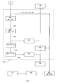
- the optimization loop proceeds as follows.
- the petrophysical properties (lithofacies, porosities, permeabilities 7) are generated on a first grid and all of these data constitute the geological model of the reservoir.
- the geological grid can be relatively fine, it is scaled ("upscaling" in English) of these properties on a coarser grid, called flow grid, in order to reduce the computation time during the simulation. .
- the production history is then simulated on this grid. This simulation makes it possible to calculate production data at the wells but also pressure maps, water saturations, oil and gas at different dates.
- 4D seismic data is available, these maps are transmitted to a petro-elastic model that calculates the seismic attributes of the model. These seismic attributes and simulated production data are then compared to the data measured via the objective function.
- the grid used by the petro-elastic model may have a resolution finer than the flow grid, or even be identical to that of the geological model. Scaling of the pressure and saturation maps of the flow gate to the seismic grid is then necessary. This step is called downscaling. If the flow grid was built by agglomerating the meshes of the petro-elastic model, a simple way of doing this downscaling is to attribute the pressures and saturations of a mesh of the flow grid to the fine meshes sub- underlying. But this method is not very precise in practice because it does not take into account the underlying heterogeneities within a coarse mesh.
- the spatial variations of the pressure and the distribution of the saturations depend strongly on the porosities, absolute and relative permeabilities present on the fine scale. If these heterogeneities are not taken into account, the calculation of the seismic attributes becomes less precise because the impedances themselves are sensitive to pressure and saturation variations.
- the downscaling of pressures and saturations therefore aims to calculate seismic attributes more representative of the geological model and to reduce the error introduced by upscaling.
- u denotes a fine mesh included in a coarse mesh v
- S one of the three saturations
- ⁇ the porosity
- ⁇ ( v ) the arithmetic mean of the porosity on the mesh v .
- the object of the invention relates to an alternative method for optimizing the exploitation of an underground environment, from a geological model.
- the method includes a calibration history of this model on dynamic data, using, for the calibration of the seismic data, a reconstruction on the fine grid of pressure fields and saturations.
- An equation in pressure is solved locally on the fine grid, the saturations are, they, calculated, at the level of each coarse mesh, by writing the continuity of the flows of the phases between neighboring lithofacies, the conservation of the pore volume and the conservation of the volume of the phases.
- the flow model can be modified by modifying petrophysical property values associated with each cell of the second grid, the model with the modified values is used to define an optimum scheme for exploiting the underground environment, and can then exploit the underground environment according to this exploitation scheme.
- the porosity of a mesh of the second grid is less than a first threshold set, no pressure value is assigned to this mesh, and flows with neighboring meshs are considered null; and if the permeability of a mesh of the second grid is smaller than a second threshold set, this mesh is assigned a pressure value equal to a pressure before the exploitation of the medium, and flows with neighboring meshes are considered as zero.
- the porosity of an identified zone is less than a first fixed threshold, no saturation value is assigned to this zone; and if the permeability of an identified zone is less than a second fixed threshold, this zone is assigned a saturation value equal to a saturation before the operation of the medium.
- Geological formations are generally very heterogeneous environments.
- the modeling of an underground deposit that is to say the construction of a representation of this deposit, called the geological model, requires the use of so-called "probabilistic" construction processes because of the limited number of information available. (number of wells restricted, ).
- the construction of a geological model depends first of all on the environment of the geological repository, which makes it possible to represent the major heterogeneities that control the flow of fluids.
- the integration of static data in this model involves linear operations and can be done from geostatistical techniques well known to specialists.
- a geological model represented on a computer, consists of a grid with N dimensions (N> 0 and generally equal to two or three) each of whose meshes is assigned a value of characteristic properties of the studied area. These properties are called petrophysical properties (PP). This may be, for example, lithology, porosity, and permeability. These values constitute maps.
- PP petrophysical properties
- a model is a grid associated with at least one map.
- the grid of a geological model is called “fine” because it has a large number of meshes, so as to best represent the heterogeneities of the environment.
- a flow model consists of a so-called “coarse” grid, that is to say a grid comprising larger and less numerous meshs than those of the geological model.
- a fine grid of a geological model is noted GF, and a rough grid of a flow model is denoted GG.
- a geostatistical model based on a random Gaussian field is used to generate the porosity ( ⁇ ) and density ( ⁇ ) fields.
- the geological model in lithofacies may be advantageous to first dress the geological model in lithofacies, that is to say the type of rock.
- this description of the lithofacies reservoir makes it possible to work with lithofacies, that is to say that one can define laws of probability, different types of simulation by lithofacies, thus making the model more precise.
- This method has the advantage of being compatible with the technique of gradual deformations, which makes the method more efficient. Any other method of using gradual deformations in solving the inverse problem can also be used to advantage.
- the cladding can be constrained by one or more seismic attributes directly (simulation techniques with external drift or co-simulations for example) or indirectly (proportion curves derived from seismic attributes).
- the reservoir properties can be associated with the mesh of the geological model by generating random numbers, then by applying a simulation method.
- a set of random numbers makes it possible to simulate values of lithofacies in any mesh of the model, and another set of random numbers makes it possible to simulate reservoir property values in all mesh of the model.
- new random numbers can be generated to update the geological model.
- Dynamic data is therefore acquired during the exploitation of the deposit. This is data whose particularity is to vary over time depending on the flow of fluids in the tank. This is typically 4D seismic data (DS) and production data (DP), such as well testing or breakthrough time. This step is performed using measurement tools such as flow meters or seismic surveys.
- the seismic data (DS) is represented on a grid, in which each cell has at least one value of a seismic attribute.
- This step is performed by means of a computer running a technical software called flow simulator, to simulate the dynamic data from the representation of the deposit, and another computer tool to simulate seismic data from the representation of the deposit.
- a flow model represented on a computer, consists of a coarse grid (GG) with N dimensions (N> 0 and generally equal two or three), each of whose meshes is assigned the value of a characteristic property. of the studied area. This may be, for example, the porosity or the permeability distributed in a reservoir (PP). These values constitute maps.
- a model is a grid associated with at least one map.
- the flow simulation is performed from a software called flow simulator. This tool is well known to specialists.
- these pressures and saturations are then used by a petro-elastic model (PEM) to simulate so-called synthetic seismic data (DS *) at the same dates, thus allowing a comparison of the model with the acquired seismic data.
- PEM petro-elastic model
- This consists of calculating pressure (P) and saturation (S) maps at the same resolution as the seismic data grid from the pressure (P) and saturation (S) maps from the flow simulator. .
- the grids of the seismic data and the geological model are identical, which in practice is often verified since part of the information from the seismic is used to construct the initial geological model.
- the grid of the flow model is constructed by agglomerating the meshes of the geological model. Downscaling in this invention is achieved by two different algorithms for pressures and saturations.
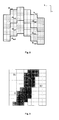
- the flow grid is partitioned into a set of related subdomains consisting of a few coarse meshes. (see figure 2 ).
- the figure 2 shows, on a 2D vertical section, an example of partition of the geological mesh in sub-domains before a downscaling of the pressures of the rough grid on the fine grid.
- the meshes of the fine grid are indicated in dotted lines, those of the flow grid in solid lines.
- the subdomain boundaries are shown in bold lines.
- the total flows or downhole pressures provided by the simulator are used to calculate the flows between the perforations and the reservoir.
- Dead mesh is a mesh having a porosity and / or permeability lower (s) at a certain threshold set by the tank engineer. If the porosity of a fine mesh is too low, it is considered that no fluid is present, the pressures and saturations are not defined and no calculation is made for this mesh. Flows with its neighboring meshes are considered null. If only the permeability is low in a mesh, this mesh retains these pressures and initial saturations, that is to say before exploitation of the deposit. Flows with its neighboring meshes are also null.
- the charts giving the initial pressures and saturations can be obtained by performing the calculation of the initial state with the simulator, directly on the grid of the geological model. Since this calculation does not require any iteration in time, this step is inexpensive in computation time.
- the relative permeability curves used here may be different from one zone to another if specific curves have been defined for each lithofacies. These curves by connected zone are noted: kr ⁇ , Rn .
- This first system of equations (S1) is not sufficient to calculate the saturations of the phases in these zones.
- the conservation of the pore volume in each zone (R n ) and the conservation of the volume of each phase in the coarse mesh are written using the values calculated by the flow simulation.
- This second set of equations is noted (S2).
- One of the objectives of the method according to the invention is to make the geological model thus constructed consistent with the seismic data.
- the pressure and saturation maps make it possible, in a manner known to those skilled in the art, to evaluate the densities and the compressibility modules of the fluids. Then, from densities and compressibility modules, the velocities of the compression (P wave) and shear (S wave) waves are calculated.
- the seismic data thus simulated must then be compared with the observed seismic data.
- the objective function conventionally includes a term measuring the difference between the simulated and observed production data (DP * -DP) and a term measuring the difference between the simulated and observed seismic data (DS * -DS).
- DP * -DP a term measuring the difference between the simulated and observed production data
- DS * -DS a term measuring the difference between the simulated and observed seismic data
- At least one of the sets of parameters X1, X2, X3 and X4 is modified. These variations are noted: ⁇ X1, ⁇ X2, ⁇ X3, ⁇ X4.
- the optimal scenario is determined by comparing, for example, the volume of oil recovered.
- the optimal scenario being, in this case, the one likely to provide the maximum recovery.
- the deposit is then exploited according to this exploitation scheme.
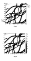
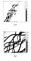
- the figures 5 and 6 show P-type impedances (compression waves) before start of operation and differences after 3000 days. These values were calculated by performing the flow simulation on the geological grid (thus without upscaling or downscaling). On the figure 6 , we can observe the impedance drops due to the migration of gas in the channels. In sandy areas not swept by gas, there is an increase in impedances related to the decrease in pressure following production. Outside, in the clay, the impedances retain their initial values.
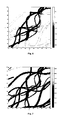
- the figures 7 and 8 show the results obtained when upscaling the petrophysical properties and downscaling the pressure and saturation maps by simply assigning the values of a mesh of the flow grid to the underlying fine meshes.
Landscapes
- Life Sciences & Earth Sciences (AREA)
- Geology (AREA)
- General Life Sciences & Earth Sciences (AREA)
- Physics & Mathematics (AREA)
- Mining & Mineral Resources (AREA)
- Engineering & Computer Science (AREA)
- General Physics & Mathematics (AREA)
- Fluid Mechanics (AREA)
- Environmental & Geological Engineering (AREA)
- Geophysics (AREA)
- Geochemistry & Mineralogy (AREA)
- Management, Administration, Business Operations System, And Electronic Commerce (AREA)
- Geophysics And Detection Of Objects (AREA)
Applications Claiming Priority (1)
| Application Number | Priority Date | Filing Date | Title |
|---|---|---|---|
| FR1004890A FR2969206B1 (fr) | 2010-12-15 | 2010-12-15 | Procede d'exploitation d'un gisement petrolier a partir d'un modele d'ecoulement cale au moyen d'une mise a l'echelle de cartes de pression et de saturation |
Publications (2)
| Publication Number | Publication Date |
|---|---|
| EP2466338A1 true EP2466338A1 (de) | 2012-06-20 |
| EP2466338B1 EP2466338B1 (de) | 2020-09-23 |
Family
ID=44148927
Family Applications (1)
| Application Number | Title | Priority Date | Filing Date |
|---|---|---|---|
| EP11290555.9A Active EP2466338B1 (de) | 2010-12-15 | 2011-12-02 | Ausbeutungsverfahren eines Erdöllagers auf der Grundlage eines stabilen Abflussmodells mittels einer skalengetreuen Normierung der Druck- und Sättigungskarten |
Country Status (4)
| Country | Link |
|---|---|
| US (1) | US8868390B2 (de) |
| EP (1) | EP2466338B1 (de) |
| CA (1) | CA2761953C (de) |
| FR (1) | FR2969206B1 (de) |
Cited By (1)
| Publication number | Priority date | Publication date | Assignee | Title |
|---|---|---|---|---|
| EP2781687A1 (de) * | 2013-03-20 | 2014-09-24 | IFP Energies nouvelles | Verfahren zum Betreiben eines geologischen Reservoirs unter Verwendung eines mit einem geologischen Modell konsistenten Reservoir-Modells durch Auswahl einer Methode der Maßstabsanpassung |
Families Citing this family (22)
| Publication number | Priority date | Publication date | Assignee | Title |
|---|---|---|---|---|
| FR2987149B1 (fr) * | 2012-02-16 | 2014-10-31 | IFP Energies Nouvelles | Procede d'exploitation d'un gisement a partir d'une technique de selection des positions de puits a forer |
| US9910938B2 (en) * | 2012-06-20 | 2018-03-06 | Schlumberger Technology Corporation | Shale gas production forecasting |
| EP2895893A1 (de) * | 2012-09-13 | 2015-07-22 | Chevron U.S.A. Inc. | System und verfahren zur gleichzeitigen petrophysischen analyse der zusammensetzung und textur von gesteinsformationen |
| GB2532153B (en) * | 2013-08-07 | 2018-06-13 | Landmark Graphics Corp | Static earth model calibration methods and systems using permeability testing |
| US10208577B2 (en) * | 2013-10-09 | 2019-02-19 | Chevron U.S.A. Inc. | Method for efficient dynamic gridding |
| FR3013126B1 (fr) * | 2013-11-14 | 2015-12-04 | IFP Energies Nouvelles | Procede de construction d'une grille representative de la distribution d'une propriete par simulation statistique multipoint conditionnelle |
| US10552553B2 (en) | 2015-08-17 | 2020-02-04 | Saudi Arabian Oil Company | Capillary pressure analysis for petrophysical statistical modeling |
| US20180196897A1 (en) * | 2015-08-21 | 2018-07-12 | Halliburton Energy Services, Inc. | Method And Apparatus For Production Logging Tool (PLT) Results Interpretation |
| CN107423475A (zh) * | 2017-05-05 | 2017-12-01 | 中国石油化工股份有限公司 | 砂岩百分含量约束的岩相建模方法 |
| CN110069797B (zh) * | 2018-01-24 | 2021-10-29 | 中国石油化工股份有限公司 | 缝洞型油藏井间连通性的判断方法及系统 |
| CN108710734B (zh) * | 2018-05-04 | 2022-12-20 | 特雷西能源科技(杭州)有限公司 | 基于网格自适应加密与粗化技术的数值模拟方法和装置 |
| CN108665534B (zh) * | 2018-05-10 | 2022-05-13 | 昆仑数智科技有限责任公司 | 一种注水油藏流线数值模拟的在线三维可视化方法 |
| WO2020028046A1 (en) * | 2018-07-31 | 2020-02-06 | Exxonmobil Upstream Research Company | Fluid saturation model for petrophysical inversion |
| CN109356564B (zh) * | 2018-11-08 | 2021-11-23 | 中国海洋石油集团有限公司 | 一种基于三元动态参数的水驱油相渗时变规律表征方法 |
| WO2020229862A1 (en) * | 2019-05-10 | 2020-11-19 | Total Se | Method for modelling a water current in a geological gridded model of a sedimentary area |
| CN113554259B (zh) * | 2020-04-26 | 2024-04-16 | 中国石油化工股份有限公司 | 一种渗流阻力与驱替压力双场匹配优化评价方法 |
| CN111810119B (zh) * | 2020-07-21 | 2022-06-28 | 重庆科技学院 | 一种高压碳酸盐岩有水气藏气井产能计算方法 |
| CN112012728B (zh) * | 2020-08-19 | 2024-03-26 | 中国石油天然气股份有限公司 | 一种聚合物在储层隙间流速的确定方法 |
| US20230195957A1 (en) * | 2021-12-20 | 2023-06-22 | Saudi Arabian Oil Company | Automatic calibration for a water injection network model |
| CN114371116B (zh) * | 2021-12-30 | 2024-06-18 | 北京红山信息科技研究院有限公司 | 一种基于渗透率的路测质量评估方法 |
| US20230375744A1 (en) * | 2022-05-17 | 2023-11-23 | ExxonMobil Technology and Engineering Company | Methods and systems for constraining subsurface models |
| CN115841181B (zh) * | 2022-12-02 | 2023-06-20 | 昆仑数智科技有限责任公司 | 剩余油分布预测方法、装置、设备及存储介质 |
Citations (1)
| Publication number | Priority date | Publication date | Assignee | Title |
|---|---|---|---|---|
| EP1728967A1 (de) * | 2005-06-03 | 2006-12-06 | Institut Français du Pétrole | Verfahren zur Aktualisierung eines geologischen Modells mittels seismischer Daten und Verfahren zur Herstellung |
-
2010
- 2010-12-15 FR FR1004890A patent/FR2969206B1/fr not_active Expired - Fee Related
-
2011
- 2011-12-02 EP EP11290555.9A patent/EP2466338B1/de active Active
- 2011-12-09 US US13/315,333 patent/US8868390B2/en not_active Expired - Fee Related
- 2011-12-13 CA CA2761953A patent/CA2761953C/fr not_active Expired - Fee Related
Patent Citations (1)
| Publication number | Priority date | Publication date | Assignee | Title |
|---|---|---|---|---|
| EP1728967A1 (de) * | 2005-06-03 | 2006-12-06 | Institut Français du Pétrole | Verfahren zur Aktualisierung eines geologischen Modells mittels seismischer Daten und Verfahren zur Herstellung |
Non-Patent Citations (16)
| Title |
|---|
| ENCHERY G. ET AL: "An Improved Pressure and Saturation Downscaling Process for a Better Integration of 4D Seismic Data Together with Production History", SPE, vol. SPE, no. 107088, 11 June 2007 (2007-06-11), pages 1 - 7, XP007918941 * |
| G. ENCHERY (IFP), F. ROGGERO (IFP), M. LE RAVALEC (IFP), E. TILLIER (IFP) & V.GERVAIS (IFP): "A New Parameterization Technique for the Calibration of Facies Proportions in History matching Processes", ECMOR, vol. ECMOR XII, no. B009, 6 September 2010 (2010-09-06), pages 1 - 13, XP007918943 * |
| J. W. BARKER; S. THIBEAU: "A Critical Review of the Use of Pseudorelative Permeabilities for Upscaling", EUROPEAN 3D RESERVOIR MODELLING CONFERENCE, 1996 |
| L. SHAPIRO; G. STOCKMAN: "Computer Vision", 2002, PRENTICE HALL, pages: 69 - 73 |
| L.J. DURLOFSKY: "Upscaling of Geocellular Models for Reservoir Flow Simulation: A Review of Recent Progress", PAPER PRESENTED AT 7TH INTERNATIONAL FORUM ON RESERVOIR SIMULATION, 23 June 2003 (2003-06-23) |
| L.-Y. HU.: "Gradual deformation and iterative calibration of Gaussian-related Stochastic Models", MATHEMATICAL GEOLOGY, vol. 32, 2000, pages 87 - 108 |
| LE RAVALEC-DUPIN, M. ET AL: "Pre-selection of Reservoir Models From a Geostatistics-based Petrophysical Seismic Inversion", SPE 131310, vol. SPE, 131310, 14 June 2010 (2010-06-14), pages 1 - 12, XP007918942 * |
| LERAT O ET AL: "Construction of a Stochastic Geological Model Constrained by High-Resolution 3D Seismic Data - Application to the Girassol Field Offshore Angola", SPE INTERNATIONAL OIL AND GAS CONFERENCE AND EXHIBITION, 11 November 2007 (2007-11-11), pages 1 - 16, XP002568891 * |
| M. LE RAVALEC-DUPIN; B. NOETINGER: "Optimization with the Gradual Deformation Method", MATHEMATICAL GEOLOGY, vol. 34, no. 2, 1 February 2002 (2002-02-01), pages 125 - 142 |
| M. SENGUPTA: "PhD thesis", 2000, STANFORD UNIVERSITY, article "Integrating rock physics and flow simulation to reduce uncertainties in seismic reservoir monitoring" |
| MATHERON G.; BEUCHER H.; DE FOUQUET C.; GALLI A.; GUERILLOT D.; RAVENNE C.: "Conditional simulation of the geometry of fluvio deltaic reservoirs", SPE 62ND ANNUAL CONFERENCE, DALLAS, TEXAS, 1987, pages 591 - 599 |
| PH. RENARD; G. DE MARSILY: "Calculating equivalent permeability: a review", ADVANCES IN WATER RESOURCES, vol. 20, no. 5-6, 1997, pages 253 - 278 |
| ROGGERO F ET AL: "Matching of Production History and 4D Seismic Data - Application to the Girassol Field, Offshore Angola", SPE INTERNATIONAL OIL AND GAS CONFERENCE AND EXHIBITION, 11 November 2007 (2007-11-11), pages 1 - 20, XP002568892 * |
| S. A. CASTRO: "PhD thesis", 2007, STANFORD UNIVERSITY, article "A Probabilistic Approach To Jointly Integrate 3D/4D Seismic, Production Data and Geological Information for Building Reservoir Models" |
| X-H WANG; M. QUINTARD; G. DARCHE: "Adaptive Mesh Refinement for One- dimensional Three-phase Flow with Phase Change in Porous Media", NUMERICAL HEAT TRANSFER, vol. 50, 2006, pages 231 - 268 |
| Y. GAUTIER; M. J. BLUNT; M. A. CHRISTIE: "Nested gridding and streamline-based simulation reservoir performance prediction", COMPUTATIONAL GEOSCIENCES, vol. 3, 1999, pages 295 - 320 |
Cited By (2)
| Publication number | Priority date | Publication date | Assignee | Title |
|---|---|---|---|---|
| EP2781687A1 (de) * | 2013-03-20 | 2014-09-24 | IFP Energies nouvelles | Verfahren zum Betreiben eines geologischen Reservoirs unter Verwendung eines mit einem geologischen Modell konsistenten Reservoir-Modells durch Auswahl einer Methode der Maßstabsanpassung |
| FR3003597A1 (fr) * | 2013-03-20 | 2014-09-26 | IFP Energies Nouvelles | Procede d'exploitation d'un reservoir geologique au moyen d'un modele de reservoir coherent avec un modele geologique par choix d'une methode d'une mise a l'echelle |
Also Published As
| Publication number | Publication date |
|---|---|
| FR2969206B1 (fr) | 2013-11-01 |
| EP2466338B1 (de) | 2020-09-23 |
| FR2969206A1 (fr) | 2012-06-22 |
| US8868390B2 (en) | 2014-10-21 |
| CA2761953A1 (fr) | 2012-06-15 |
| CA2761953C (fr) | 2020-10-27 |
| US20120158378A1 (en) | 2012-06-21 |
Similar Documents
| Publication | Publication Date | Title |
|---|---|---|
| EP2466338B1 (de) | Ausbeutungsverfahren eines Erdöllagers auf der Grundlage eines stabilen Abflussmodells mittels einer skalengetreuen Normierung der Druck- und Sättigungskarten | |
| EP2270548B1 (de) | Methode zur Veränderung der Proportionen von Gesteinsfazien bei der Einstellung einer Zeitreihe eines geologischen Modells | |
| EP3144468B1 (de) | Verfahren zur charakterisierung des bruchnetzes eines bruchlagers, und verfahren zu dessen ausbeutung | |
| EP2037080B1 (de) | Methode zur abschätzung der durchlässigkeit eines frakturnetzes mit hilfe einer vernetzungsanalyse | |
| EP1801617B1 (de) | Verfahren zur Aktualisierung eines geologischen Modells mittels seismischer Daten | |
| US8862450B2 (en) | Method of developing a petroleum reservoir from history matching of production data and seismic data | |
| EP2453106B1 (de) | Methode zur Charakterisierung des Bruchnetzes eines Bruchlagers, und Methode zu dessen Ausbeutung | |
| FR2823877A1 (fr) | Methode pour contraindre par des donnees dynamiques de production un modele fin representatif de la repartition dans le gisement d'une grandeur physique caracteristique de la structure du sous-sol | |
| EP2770162B1 (de) | Verfahren zur Ausbeutung eines geologischen Speichers mit Hilfe eines intelligenten und kohärenten Speichermodells in Bezug auf die Ablaufeigenschaften | |
| FR2918777A1 (fr) | Procede, programme et systeme informatique de consiliation de donnees de modele de reservoir d'hydrocarbure. | |
| EP2400320B1 (de) | Verfahren zur Ausbeutung eines Erdöllagers mit Hilfe eines Reservoir-Modells, das schrittweise durch Co-Simulationen verformt wird | |
| EP3181804A1 (de) | Verfahren zur charakterisierung und nutzung einer unterirdischen formation, die ein bruchnetzwerk umfasst | |
| EP3327471B1 (de) | Verfahren zum abbau eines kohlenwasserstofflagers durch simulation des produktionsverlaufs in abhängigkeit von der diagenese | |
| FR2954557A1 (fr) | Methode d'exploitation d'un gisement petrolier a partir d'une construction d'une carte de facies | |
| EP2469306A2 (de) | Verfahren zur Lokalisierung von hydraulischen Sperrschichten innerhalb einer geologischen Gaslagerschicht | |
| EP2685291A2 (de) | Verfahren zur Ausbeutung eines geologischen Speichers auf der Grundlage eines Speichermodells, das auf einer Berechnung eines analytischen Verteilungsgesetzes beruht, das durch unsichere Parameter des Modells bedingt ist | |
| EP3252508B1 (de) | Verfahren zur kohlenwasserstoffgewinnung aus einer unterirdischen formation mithilfe einer optimierten skalierung | |
| EP2594733A1 (de) | Verfahren zum Optimieren der Nutzung eines unterirdischen Raums mit Hilfe einer Aufnahmestudie mit optimierter Maßstabstreue | |
| EP2781687A1 (de) | Verfahren zum Betreiben eines geologischen Reservoirs unter Verwendung eines mit einem geologischen Modell konsistenten Reservoir-Modells durch Auswahl einer Methode der Maßstabsanpassung | |
| US20260029550A1 (en) | Geology-based facies trend modeling for hydrocarbon extraction | |
| FR2947642A1 (fr) | Methode pour modifier des proportions de facies lors du calage d'historique d'un modele geologique |
Legal Events
| Date | Code | Title | Description |
|---|---|---|---|
| PUAI | Public reference made under article 153(3) epc to a published international application that has entered the european phase |
Free format text: ORIGINAL CODE: 0009012 |
|
| AK | Designated contracting states |
Kind code of ref document: A1 Designated state(s): AL AT BE BG CH CY CZ DE DK EE ES FI FR GB GR HR HU IE IS IT LI LT LU LV MC MK MT NL NO PL PT RO RS SE SI SK SM TR |
|
| AX | Request for extension of the european patent |
Extension state: BA ME |
|
| 17P | Request for examination filed |
Effective date: 20121220 |
|
| 17Q | First examination report despatched |
Effective date: 20160425 |
|
| RAP1 | Party data changed (applicant data changed or rights of an application transferred) |
Owner name: IFP ENERGIES NOUVELLES |
|
| STAA | Information on the status of an ep patent application or granted ep patent |
Free format text: STATUS: EXAMINATION IS IN PROGRESS |
|
| GRAP | Despatch of communication of intention to grant a patent |
Free format text: ORIGINAL CODE: EPIDOSNIGR1 |
|
| STAA | Information on the status of an ep patent application or granted ep patent |
Free format text: STATUS: GRANT OF PATENT IS INTENDED |
|
| INTG | Intention to grant announced |
Effective date: 20200429 |
|
| GRAS | Grant fee paid |
Free format text: ORIGINAL CODE: EPIDOSNIGR3 |
|
| GRAA | (expected) grant |
Free format text: ORIGINAL CODE: 0009210 |
|
| STAA | Information on the status of an ep patent application or granted ep patent |
Free format text: STATUS: THE PATENT HAS BEEN GRANTED |
|
| AK | Designated contracting states |
Kind code of ref document: B1 Designated state(s): AL AT BE BG CH CY CZ DE DK EE ES FI FR GB GR HR HU IE IS IT LI LT LU LV MC MK MT NL NO PL PT RO RS SE SI SK SM TR |
|
| REG | Reference to a national code |
Ref country code: GB Ref legal event code: FG4D Free format text: NOT ENGLISH |
|
| REG | Reference to a national code |
Ref country code: CH Ref legal event code: EP |
|
| REG | Reference to a national code |
Ref country code: IE Ref legal event code: FG4D Free format text: LANGUAGE OF EP DOCUMENT: FRENCH |
|
| REG | Reference to a national code |
Ref country code: AT Ref legal event code: REF Ref document number: 1316969 Country of ref document: AT Kind code of ref document: T Effective date: 20201015 Ref country code: DE Ref legal event code: R096 Ref document number: 602011068688 Country of ref document: DE |
|
| PG25 | Lapsed in a contracting state [announced via postgrant information from national office to epo] |
Ref country code: SE Free format text: LAPSE BECAUSE OF FAILURE TO SUBMIT A TRANSLATION OF THE DESCRIPTION OR TO PAY THE FEE WITHIN THE PRESCRIBED TIME-LIMIT Effective date: 20200923 Ref country code: FI Free format text: LAPSE BECAUSE OF FAILURE TO SUBMIT A TRANSLATION OF THE DESCRIPTION OR TO PAY THE FEE WITHIN THE PRESCRIBED TIME-LIMIT Effective date: 20200923 Ref country code: GR Free format text: LAPSE BECAUSE OF FAILURE TO SUBMIT A TRANSLATION OF THE DESCRIPTION OR TO PAY THE FEE WITHIN THE PRESCRIBED TIME-LIMIT Effective date: 20201224 Ref country code: BG Free format text: LAPSE BECAUSE OF FAILURE TO SUBMIT A TRANSLATION OF THE DESCRIPTION OR TO PAY THE FEE WITHIN THE PRESCRIBED TIME-LIMIT Effective date: 20201223 Ref country code: HR Free format text: LAPSE BECAUSE OF FAILURE TO SUBMIT A TRANSLATION OF THE DESCRIPTION OR TO PAY THE FEE WITHIN THE PRESCRIBED TIME-LIMIT Effective date: 20200923 |
|
| PGFP | Annual fee paid to national office [announced via postgrant information from national office to epo] |
Ref country code: NO Payment date: 20201218 Year of fee payment: 10 Ref country code: FR Payment date: 20201229 Year of fee payment: 10 Ref country code: GB Payment date: 20201228 Year of fee payment: 10 |
|
| REG | Reference to a national code |
Ref country code: AT Ref legal event code: MK05 Ref document number: 1316969 Country of ref document: AT Kind code of ref document: T Effective date: 20200923 |
|
| REG | Reference to a national code |
Ref country code: NO Ref legal event code: T2 Effective date: 20200923 |
|
| PG25 | Lapsed in a contracting state [announced via postgrant information from national office to epo] |
Ref country code: RS Free format text: LAPSE BECAUSE OF FAILURE TO SUBMIT A TRANSLATION OF THE DESCRIPTION OR TO PAY THE FEE WITHIN THE PRESCRIBED TIME-LIMIT Effective date: 20200923 Ref country code: LV Free format text: LAPSE BECAUSE OF FAILURE TO SUBMIT A TRANSLATION OF THE DESCRIPTION OR TO PAY THE FEE WITHIN THE PRESCRIBED TIME-LIMIT Effective date: 20200923 |
|
| PGFP | Annual fee paid to national office [announced via postgrant information from national office to epo] |
Ref country code: NL Payment date: 20201229 Year of fee payment: 10 |
|
| REG | Reference to a national code |
Ref country code: LT Ref legal event code: MG4D |
|
| PG25 | Lapsed in a contracting state [announced via postgrant information from national office to epo] |
Ref country code: SM Free format text: LAPSE BECAUSE OF FAILURE TO SUBMIT A TRANSLATION OF THE DESCRIPTION OR TO PAY THE FEE WITHIN THE PRESCRIBED TIME-LIMIT Effective date: 20200923 Ref country code: RO Free format text: LAPSE BECAUSE OF FAILURE TO SUBMIT A TRANSLATION OF THE DESCRIPTION OR TO PAY THE FEE WITHIN THE PRESCRIBED TIME-LIMIT Effective date: 20200923 Ref country code: PT Free format text: LAPSE BECAUSE OF FAILURE TO SUBMIT A TRANSLATION OF THE DESCRIPTION OR TO PAY THE FEE WITHIN THE PRESCRIBED TIME-LIMIT Effective date: 20210125 Ref country code: LT Free format text: LAPSE BECAUSE OF FAILURE TO SUBMIT A TRANSLATION OF THE DESCRIPTION OR TO PAY THE FEE WITHIN THE PRESCRIBED TIME-LIMIT Effective date: 20200923 Ref country code: EE Free format text: LAPSE BECAUSE OF FAILURE TO SUBMIT A TRANSLATION OF THE DESCRIPTION OR TO PAY THE FEE WITHIN THE PRESCRIBED TIME-LIMIT Effective date: 20200923 Ref country code: CZ Free format text: LAPSE BECAUSE OF FAILURE TO SUBMIT A TRANSLATION OF THE DESCRIPTION OR TO PAY THE FEE WITHIN THE PRESCRIBED TIME-LIMIT Effective date: 20200923 |
|
| PG25 | Lapsed in a contracting state [announced via postgrant information from national office to epo] |
Ref country code: PL Free format text: LAPSE BECAUSE OF FAILURE TO SUBMIT A TRANSLATION OF THE DESCRIPTION OR TO PAY THE FEE WITHIN THE PRESCRIBED TIME-LIMIT Effective date: 20200923 Ref country code: IS Free format text: LAPSE BECAUSE OF FAILURE TO SUBMIT A TRANSLATION OF THE DESCRIPTION OR TO PAY THE FEE WITHIN THE PRESCRIBED TIME-LIMIT Effective date: 20210123 Ref country code: ES Free format text: LAPSE BECAUSE OF FAILURE TO SUBMIT A TRANSLATION OF THE DESCRIPTION OR TO PAY THE FEE WITHIN THE PRESCRIBED TIME-LIMIT Effective date: 20200923 Ref country code: AL Free format text: LAPSE BECAUSE OF FAILURE TO SUBMIT A TRANSLATION OF THE DESCRIPTION OR TO PAY THE FEE WITHIN THE PRESCRIBED TIME-LIMIT Effective date: 20200923 Ref country code: AT Free format text: LAPSE BECAUSE OF FAILURE TO SUBMIT A TRANSLATION OF THE DESCRIPTION OR TO PAY THE FEE WITHIN THE PRESCRIBED TIME-LIMIT Effective date: 20200923 |
|
| REG | Reference to a national code |
Ref country code: DE Ref legal event code: R097 Ref document number: 602011068688 Country of ref document: DE |
|
| PG25 | Lapsed in a contracting state [announced via postgrant information from national office to epo] |
Ref country code: SK Free format text: LAPSE BECAUSE OF FAILURE TO SUBMIT A TRANSLATION OF THE DESCRIPTION OR TO PAY THE FEE WITHIN THE PRESCRIBED TIME-LIMIT Effective date: 20200923 |
|
| REG | Reference to a national code |
Ref country code: DE Ref legal event code: R119 Ref document number: 602011068688 Country of ref document: DE |
|
| PLBE | No opposition filed within time limit |
Free format text: ORIGINAL CODE: 0009261 |
|
| REG | Reference to a national code |
Ref country code: CH Ref legal event code: PL |
|
| STAA | Information on the status of an ep patent application or granted ep patent |
Free format text: STATUS: NO OPPOSITION FILED WITHIN TIME LIMIT |
|
| PG25 | Lapsed in a contracting state [announced via postgrant information from national office to epo] |
Ref country code: SI Free format text: LAPSE BECAUSE OF FAILURE TO SUBMIT A TRANSLATION OF THE DESCRIPTION OR TO PAY THE FEE WITHIN THE PRESCRIBED TIME-LIMIT Effective date: 20200923 Ref country code: MC Free format text: LAPSE BECAUSE OF FAILURE TO SUBMIT A TRANSLATION OF THE DESCRIPTION OR TO PAY THE FEE WITHIN THE PRESCRIBED TIME-LIMIT Effective date: 20200923 Ref country code: DK Free format text: LAPSE BECAUSE OF FAILURE TO SUBMIT A TRANSLATION OF THE DESCRIPTION OR TO PAY THE FEE WITHIN THE PRESCRIBED TIME-LIMIT Effective date: 20200923 |
|
| 26N | No opposition filed |
Effective date: 20210624 |
|
| REG | Reference to a national code |
Ref country code: BE Ref legal event code: MM Effective date: 20201231 |
|
| REG | Reference to a national code |
Ref country code: NL Ref legal event code: FP |
|
| PG25 | Lapsed in a contracting state [announced via postgrant information from national office to epo] |
Ref country code: IT Free format text: LAPSE BECAUSE OF FAILURE TO SUBMIT A TRANSLATION OF THE DESCRIPTION OR TO PAY THE FEE WITHIN THE PRESCRIBED TIME-LIMIT Effective date: 20200923 Ref country code: IE Free format text: LAPSE BECAUSE OF NON-PAYMENT OF DUE FEES Effective date: 20201202 Ref country code: LU Free format text: LAPSE BECAUSE OF NON-PAYMENT OF DUE FEES Effective date: 20201202 |
|
| PG25 | Lapsed in a contracting state [announced via postgrant information from national office to epo] |
Ref country code: DE Free format text: LAPSE BECAUSE OF NON-PAYMENT OF DUE FEES Effective date: 20210701 Ref country code: CH Free format text: LAPSE BECAUSE OF NON-PAYMENT OF DUE FEES Effective date: 20201231 Ref country code: LI Free format text: LAPSE BECAUSE OF NON-PAYMENT OF DUE FEES Effective date: 20201231 |
|
| PG25 | Lapsed in a contracting state [announced via postgrant information from national office to epo] |
Ref country code: TR Free format text: LAPSE BECAUSE OF FAILURE TO SUBMIT A TRANSLATION OF THE DESCRIPTION OR TO PAY THE FEE WITHIN THE PRESCRIBED TIME-LIMIT Effective date: 20200923 Ref country code: MT Free format text: LAPSE BECAUSE OF FAILURE TO SUBMIT A TRANSLATION OF THE DESCRIPTION OR TO PAY THE FEE WITHIN THE PRESCRIBED TIME-LIMIT Effective date: 20200923 Ref country code: CY Free format text: LAPSE BECAUSE OF FAILURE TO SUBMIT A TRANSLATION OF THE DESCRIPTION OR TO PAY THE FEE WITHIN THE PRESCRIBED TIME-LIMIT Effective date: 20200923 |
|
| PG25 | Lapsed in a contracting state [announced via postgrant information from national office to epo] |
Ref country code: MK Free format text: LAPSE BECAUSE OF FAILURE TO SUBMIT A TRANSLATION OF THE DESCRIPTION OR TO PAY THE FEE WITHIN THE PRESCRIBED TIME-LIMIT Effective date: 20200923 |
|
| REG | Reference to a national code |
Ref country code: NO Ref legal event code: MMEP |
|
| PG25 | Lapsed in a contracting state [announced via postgrant information from national office to epo] |
Ref country code: BE Free format text: LAPSE BECAUSE OF NON-PAYMENT OF DUE FEES Effective date: 20201231 |
|
| REG | Reference to a national code |
Ref country code: NL Ref legal event code: MM Effective date: 20220101 |
|
| GBPC | Gb: european patent ceased through non-payment of renewal fee |
Effective date: 20211202 |
|
| PG25 | Lapsed in a contracting state [announced via postgrant information from national office to epo] |
Ref country code: NL Free format text: LAPSE BECAUSE OF NON-PAYMENT OF DUE FEES Effective date: 20220101 |
|
| PG25 | Lapsed in a contracting state [announced via postgrant information from national office to epo] |
Ref country code: NO Free format text: LAPSE BECAUSE OF NON-PAYMENT OF DUE FEES Effective date: 20211231 Ref country code: GB Free format text: LAPSE BECAUSE OF NON-PAYMENT OF DUE FEES Effective date: 20211202 |
|
| PG25 | Lapsed in a contracting state [announced via postgrant information from national office to epo] |
Ref country code: FR Free format text: LAPSE BECAUSE OF NON-PAYMENT OF DUE FEES Effective date: 20211231 |