EP2515075A1 - Prédiction du temps pour capteur de pression - Google Patents
Prédiction du temps pour capteur de pression Download PDFInfo
- Publication number
- EP2515075A1 EP2515075A1 EP11163043A EP11163043A EP2515075A1 EP 2515075 A1 EP2515075 A1 EP 2515075A1 EP 11163043 A EP11163043 A EP 11163043A EP 11163043 A EP11163043 A EP 11163043A EP 2515075 A1 EP2515075 A1 EP 2515075A1
- Authority
- EP
- European Patent Office
- Prior art keywords
- application
- communication device
- connectivity
- information
- portable communication
- Prior art date
- Legal status (The legal status is an assumption and is not a legal conclusion. Google has not performed a legal analysis and makes no representation as to the accuracy of the status listed.)
- Withdrawn
Links
- 238000004891 communication Methods 0.000 claims abstract description 108
- 238000000034 method Methods 0.000 claims abstract description 25
- 230000000977 initiatory effect Effects 0.000 claims description 2
- 239000003570 air Substances 0.000 description 60
- 238000005259 measurement Methods 0.000 description 11
- 230000006399 behavior Effects 0.000 description 6
- 230000006870 function Effects 0.000 description 4
- 238000004804 winding Methods 0.000 description 4
- 230000008901 benefit Effects 0.000 description 3
- 238000009530 blood pressure measurement Methods 0.000 description 3
- 230000033001 locomotion Effects 0.000 description 3
- 238000010295 mobile communication Methods 0.000 description 3
- 230000033764 rhythmic process Effects 0.000 description 3
- 238000010586 diagram Methods 0.000 description 2
- 231100001261 hazardous Toxicity 0.000 description 2
- 230000009471 action Effects 0.000 description 1
- 239000012080 ambient air Substances 0.000 description 1
- 230000003542 behavioural effect Effects 0.000 description 1
- 238000012937 correction Methods 0.000 description 1
- 230000007812 deficiency Effects 0.000 description 1
- 230000003203 everyday effect Effects 0.000 description 1
- 238000010438 heat treatment Methods 0.000 description 1
- 230000002706 hydrostatic effect Effects 0.000 description 1
- 229920001690 polydopamine Polymers 0.000 description 1
- 239000011148 porous material Substances 0.000 description 1
- 230000008569 process Effects 0.000 description 1
- 238000012545 processing Methods 0.000 description 1
- 230000009467 reduction Effects 0.000 description 1
- 238000010079 rubber tapping Methods 0.000 description 1
- 238000000926 separation method Methods 0.000 description 1
- 239000005439 thermosphere Substances 0.000 description 1
- 230000001960 triggered effect Effects 0.000 description 1
- 238000010792 warming Methods 0.000 description 1
Images


Classifications
-
- G—PHYSICS
- G01—MEASURING; TESTING
- G01C—MEASURING DISTANCES, LEVELS OR BEARINGS; SURVEYING; NAVIGATION; GYROSCOPIC INSTRUMENTS; PHOTOGRAMMETRY OR VIDEOGRAMMETRY
- G01C5/00—Measuring height; Measuring distances transverse to line of sight; Levelling between separated points; Surveyors' levels
- G01C5/06—Measuring height; Measuring distances transverse to line of sight; Levelling between separated points; Surveyors' levels by using barometric means
Definitions
- the present invention relates to the field of portable electronic devices and, in particularly, to such devices having an air pressure sensor for determining the altitude of the portable electronic device, and for updating of information relating to the altitude determination.
- the present invention especially targets the area of portable mobile communication devices, such as mobile phones, where accurate altitude measurements using an altimeter application is highly sought for.
- Modern day portable communication devices are often fitted with several different types of sensors.
- the recorded data from these sensors may then utilized by applications, running in the portable communication device, to aid the user in his or hers everyday life.
- An example of such a sensor is the pressure sensor which is capable of recording the surrounding air pressure with a high degree of accuracy.
- the recorded air pressure data can then, for example, be used in an altimeter application for determining the current altitude of the portable communication device.
- the air pressure at sea level for the current position of the mobile communication device must be known. Since the air pressure at sea level for the current position is constantly changing due to the weather, it is usually acquired by the portable communication device from a local weather service via the Internet.
- the portable communication device cannot acquire the air pressure at sea level for the current position and the current altitude of the portable communication device cannot be determined with any precision. Even if the portable communication device would have old air pressure at sea level data stored it would not be wise to use it for determining the current altitude, since it would be very likely that the stored data would be outdated and not valid for the current location. Using no or outdated air pressure at sea level data will generate false estimates of the current altitude of the portable communication device, and which in worst case could deviate from the true altitude by several hundred meters. Thus, a way to achieve more reliable data on the current air pressure at sea level for the current location when the portable communication device is not capable of communicating with a weather service is highly sought for.
- an aspect of the present invention is to provide a way of determining the current altitude of a portable communication device at a specific location which seeks to mitigate, alleviate, or eliminate one or more of the above-identified deficiencies in the art and disadvantages singly or in any combination.
- a first aspect of the present invention relates to a method for updating application information of an application in a portable communication device comprising, determining the current location of said portable communication device, determining the connectivity of said portable communication device to a communication network for said current location, adaptively creating a visitation history based on said current location, said connectivity, and on previously visited locations of said portable communication device and the connectivity of said previously visited locations, predicting a next location of said portable communication device based on said current location and said visitation history, determining, based on said visitation history, if said next location provides connectivity to a communication network, if said next location is determined to provide no connectivity to said communication network, then initiating downloading of information from a server on said communication network, and updating said application information in said portable communication device with said downloaded information.
- the method may further comprises determining if said application has been executed in said portable communication device at said current location.
- the method wherein the step of adaptively creating said visitation history may further be based on if said application has been executed in said portable communication device at said current location or at said previously visited locations.
- the method may further comprises determining if said application have been executed at said next location determined to have no connectivity to a communication network, and if said application has been used at said next location determined to have no connectivity to a communication network, then updating said application information in said portable communication device with said downloaded information.
- the method wherein said updating of said application information may further comprise, comparing said application information with said downloaded information and replacing said application information with said downloaded information if said application information is older than said downloaded information.
- the method wherein the step of determining the current location may be performed by Enhanced Observed Time Difference of a network cell or by determining the position of said portable communication device using a global positioning system, or both.
- the method wherein said application may be an altimeter application.
- the method wherein said application information may be air pressure at sea level data.
- said server on said communication network may be a weather service server on the Internet.
- a second aspect of the present invention relates to an apparatus for updating application information of an application in a portable communication device comprising, a first determining unit configured to determine the current location of said portable communication device, a second determining unit configured to determine the connectivity of said portable communication device to a communication network for said current location, a compiler configured to adaptively create a visitation history based on said current location, said connectivity, and on previously visited locations of said portable communication device and the connectivity of said previously visited locations, a prediction unit configured to predict a next location of said portable communication device based on said current location and said visitation history, a third determining unit configured to determine, based on said visitation history, if said next location provides connectivity to a communication network, a decision unit configured to initiate downloading, in a downloading unit configured to download information from a server on said communication network, if said next location is determined to provide no connectivity to said communication network and an updating unit adapted to update said application information in said portable communication device with said downloaded information.
- the apparatus may further comprises a fourth determining unit configured to determine if said application has been executed in said portable communication device at said current location.
- the apparatus wherein the compiler may further be configured to base the creation of said visitation history on if said application has been executed in said portable communication device at said current location or at said previously visited locations.
- the apparatus may further comprise a fifth determining unit configured to determine if said application have been executed at said next location determined to have no connectivity to a communication network; and wherein the a decision unit is further configured to download information from said server on said communication network, if said next location is determined to provide no connectivity to said communication network and if said application is determined to have been used at said next location determined to have no connectivity to a communication network then an updating unit configured to update said application information in said portable communication device with said downloaded information.
- a fifth determining unit configured to determine if said application have been executed at said next location determined to have no connectivity to a communication network
- the a decision unit is further configured to download information from said server on said communication network, if said next location is determined to provide no connectivity to said communication network and if said application is determined to have been used at said next location determined to have no connectivity to a communication network then an updating unit configured to update said application information in said portable communication device with said downloaded information.
- said updating unit may further comprises a comparing unit configured to compare said application information with said downloaded information and a replacing unit configured to replace said application information with said downloaded information if said application information is older than said downloaded information.
- the apparatus wherein the determining of the current location in the first determining unit may be performed by Enhanced Observed Time Difference of a network cell or by determining the position of said portable communication device using a global positioning system, or both.
- Embodiments of the present invention relate, in general, to the field of portable communication devices and, in particularly, to mobile phones having a pressure sensor capable of recoding the ambient air pressure, and to the calibration of said pressure sensor.
- a barometer i.e. a device for measuring the air pressure
- an altimeter i.e. a device for measuring the altitude.
- any device such as a mobile phone, with an integrated pressure sensor (together with an altimeter software application) can be used for determining the height or altitude over sea level.
- the pressure sensor in the mobile phone the current air pressure at sea level for the location where the altitude is going to be determined must be known.
- the air pressure at sea level is not constant but fluctuates with time depending on several different factors such as the changes between low and high pressures, the reduction of air mass caused by upper level divergence (e.g. vorticity, jet streaks, etc.), the moisture advection (moist air is less dense than dry air), the warm air advection (warm air is less dense than cold air), etc.
- Trying to determine the current altitude without knowing the current air pressure at sea level at the time of measurement may result in a measurement error of the altitude up to several hundred meters. In some application this error in altitude is not acceptable and could in some cases be potential hazardous.
- a way to determining the current air pressure at sea level is by retrieving it from a server having a weather database belonging to a weather service provider.
- the weather service provider owns or has access to several weather measurement stations and weather satellites around the globe, which continuously performs accurate measurements of the air pressure at different locations, and from these measurements, derive the current air pressure at sea level for the locations.
- An altimeter application running in a mobile phone may in this way connect to one or several weather service provider's servers using one or more of the mobile phones communication capabilities, and download the current air pressure at sea level for the current location of the mobile phone.
- Figure 1a shows an example of altitude measuring system 100 using a mobile phone with a pressure sensor.
- the altitude measuring system 100 is comprised of a mobile phone 101 with a built in pressure sensor 102 measuring the current ambient pressure impinging on the mobile phone 101.
- the mobile phone 101 connects wirelessly using the mobile communication network to a server having a weather database 103, via a base station 104.
- the mobile phone or rather an application in the mobile phone determines and transmits the approximate location of the mobile phone and a request for the current air pressure at sea level at its current location.
- the weather database 103 looks up the current air pressure at sea level for the given coordinates of the mobile phone 101 and transmits it, wirelessly via the base station 104, back to the mobile phone 101.
- the mobile phone 101 receives the current pressure at sea level for the location of the mobile phone 101, stores it in the mobile phone's memory, and may now be use by the altimeter application together with the pressure sensor 102 to determine the current altitude of the mobile phone 101.
- the location of the mobile phone must be at least approximately known. The more precise the location of the mobile phone can be determined the better it is, since the weather service provider then can supply the altimeter application in the mobile phone with more accurate air pressure over sea level data.
- the current location of the mobile phone may be determined using some kind of mobile phone tracking method such as the Enhanced Observed Time Difference (E-OTD) method, Global Positioning System (GPS) positioning, communication network positioning, or some other land based or satellite based (or a combination of both land based and satellite based) positioning system.
- E-OTD Enhanced Observed Time Difference
- GPS Global Positioning System
- communication network positioning or some other land based or satellite based (or a combination of both land based and satellite based) positioning system.
- the user of the mobile phone may himself provide his current approximate location, or an approximate location where he wants to know the current air pressure at sea level, by for instance indicating on a map, entering GPS coordinates (or some other well known coordinate system), or take a picture with the mobile phone of his surroundings, and let a database identify known landmarks in the picture and use the position of the known landmarks to establish his or hers approximate location.
- the mobile phone When connecting to a weather service provider the mobile phone could either, as in the example described in conjunction with figure 1 , provide the weather service provider with its position, using one or more of the method mentioned above, or the weather service provider could try to determine the position of the mobile phone 101 based on for instance network information from the base station 104.
- the mobile phone enters into an area with no or only sporadic network connectivity, for instance when out hiking in the mountains, the current air pressure at sea level may not be available for download from a weather service provider, and thus an accurate altitude measurement can't be ensured. This could be potential hazardous especially if the user is relying on the altitude measurement of the mobile phone to track and navigate in the mountains and the last updated air pressure at sea level data is several days old and for a completely different location.
- One way of overcoming these difficulties is to use a location prediction engine together with a visitation history for planning the downloading of up-to-date air pressure at sea level data.
- the location prediction engine is capable of predicting, based on visitation history, when the mobile phone is likely to enter into an area without any connectivity to a weather service provider, and based on that prediction, the mobile phone (or rather an application in the mobile phone) may then take appropriate action to ensure that it has current air pressure at sea level data stored in the mobile phone for the current location and the location(s) with no connectivity, before losing connectivity.
- the location prediction engine works by creating and maintaining a visitation history of all locations visited by the mobile phone.
- the visitation history may be based on current and past information relating to visited network cells, recorded GPS positions, user inputted data, context awareness data, or any other passive or active tracking information. Information such as time, calendar information and information about the connectivity for each visited location may also be incorporated into the visitation history.
- the location prediction engine can, based on the visitation history and user behavioural information, recognise "visitation patterns" (such as a possible route between point A and point B) from the current behaviour of the user/users using the mobile phone, and thereby predict the next location of the mobile phone in the near future (e.g. the next location the mobile phone will arrive to). Details about how the location prediction engine works will not be discussed any further in here, but all the details can be obtained from the PCT application PCT/EP2010/057761 .
- a next location may either be predicted at given time instances or after a specific distance travelled set by the user or the manufacturer of the mobile phone or the manufacturer of the used (executed) application. Another way is to let the changes in the environment trigger a prediction of a next location for instance when the mobile phone changes network cell. Other possibility is to let the user himself trigger a prediction of a next location.
- the location prediction engine records the connectivity to weather service providers for different locations in the visitation history. In this way the local prediction engine will be able to provide the mobile phone with information regarding specific location's connectivity before arriving at that location.
- the location prediction engine comes to the conclusion that the predicted next location will probably be a location without or with poor connectivity to a weather service provider, a download is triggered where the current air pressure at sea level data for the current and predicted next location in the area without connectivity, is downloaded and stored in the mobile phone for future use.
- the stored air pressure at sea level data may be compared with the corresponding data at the weather service provider to see if there is more up-to-date air pressure at sea level data available or not.
- the downloading of current air pressure at sea level data for the current and upcoming location in the area without connectivity may in one variant only be initiated if there is a more up-to-date data at the weather service provider.
- the air pressure at sea level data is always downloaded from the weather service provider and the currently stored data, if any, is updated (replaced).
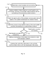
- FIG. 1b shows a flowchart describing a generalized method for updating application information, such as air pressure at sea level data, of an application, such as an altimeter application, executed in a mobile phone.
- the first step 110 is to determining the current location of the mobile phone and the connectivity of the mobile phone to a communication network, such as the Internet, for the current location.
- a communication network such as the Internet
- the visitation history 111 is updated with the current location and the connectivity of the current location.
- the visitation history 111 also based on the current location on previously visited locations and their connectivity to a communication network.
- next location of the mobile phone is predicted using the information in the visitation history and the current location, and after that it is also determined 113 if the next location of the mobile phone provides connectivity to a communication network 116 or not 115. If the next location provides connectivity to a communication network 115 the tracking application in the mobile phone keeps tracking and determining the (next) current position. However, if the next location does not provide connectivity 116 according to the visitation history, downloading of information, such as an updated air pressure at sea level data, is initiated from a server 117, such as a server on the Internet with a weather database (103), on the communication network. In the last step 118 the application information is updated with the downloaded information 117.
- a server 117 such as a server on the Internet with a weather database (103)
- the location prediction engine records not only the connectivity for different locations in the visitation history but also which application(s) or function(s) in the mobile phone that has been used or activated at the different locations. The recorded information is then integrated into the visitation history. In this way when the location prediction engine predicts 112 that the next location is likely to not have any connectivity, the mobile phone or an application in the mobile phone, first determines by using the visitation history if any application or function have been (or usually is used) at the next location without connectivity.
- the mobile phone or an application in the mobile phone initiate downloading 117 of information (for instance the current air pressure at sea level data) for the current and the next location in the area without connectivity, and the application in question is updated with the downloaded information 118. If it is found that no application is usually used or has been used in the next location without connectivity, then nothing is done and the mobile phone goes back to tracking and determining current location and connectivity 110. In this way unnecessary downloads are avoided and battery power in the mobile phone and/or cost (it may for instance cost money to download data from the weather service server) is saved.
- information for instance the current air pressure at sea level data
- the downloaded and stored application information is stored with a time stamp indicating the longest time the stored data should be used before it is to be considered outdated, obsolete and not safe to use.
- the time stamp may be determined by a preset time value which has been preset either by the user of the mobile phone, by the weather service provider or by the manufacturer of the pressure sensor, or by the manufacturer of the altimeter application.
- the preset time value may for instance be based on previous air pressure history of the specific area or location, current weather patterns, current time of day, time of year, current diurnal and a semidiurnal (12h) rhythm, or some other value coming from some pressure model.
- a warning signal may be displayed in the mobile phone to alert the user.
- the user may then either chose to; use the outdated application information anyway, adjust the outdated application information and then use it, or block the application from starting using the old application information until new and updated data can be retrieved.
- the altimeter application is manufactured to not be usable with outdated application information for safety reasons.
- the location prediction engine may have trouble establishing a location pattern of the user. This may for instance happen on weekends when the user tends to have a more ad hoc and random behaviour.
- application information such as air pressure at sea level data for the surrounding area may be set to be downloaded by regular intervals so that if the mobile phone suddenly (without the location prediction engine capable of predicting it) enters into an area without connectivity to a weather service provider (server), the application such as the altimeter still will have freshly stored air pressure at sea level data for usage.
- server weather service provider
- the pressure data should be downloaded may be determined by a preset download time value which may be preset either by the user, by the weather service provider, the manufacturer of the pressure sensor or the manufacturer of the altimeter application, and may be based on previous pressure history for the specific area or location, current weather patterns, current time of day, time of year, current diurnal and a semidiurnal (12h) rhythm, or some other pressure model.
- the location prediction engine When the location prediction engine detects a familiar location pattern it may return to its usual behaviour and thus stop downloading air pressure at sea level data on regular intervals, or it may continue to download pressure data on regular intervals for a specific amount of time, were the specific amount of time may be preset either by the user, by the weather service provider, the manufacturer of the pressure sensor or the altimeter application, just in case the location prediction engine detects an ad hoc behaviour again.
- the outdated application information i.e. the air pressure at sea level data
- the outdated application information may be adjusted to be usable even though the mobile phone is in an area without connectivity to a weather service provider (i.e. server).
- the altimeter application may use GPS data to derive a safe estimate of the current altitude which may be used as a calibration point for the altimeter application using the pressure sensor for measuring the altitude.
- Modern GPS receivers calculate its position using a coordinate system known as Earth Centered Earth Fixed xyz (ECEF XYZ).
- the center of the earth is given the coordinates 0,0,0 where the x-axis extends from that center of earth to a point at the equator where the longitude is 0, the y-axis extends from the center of earth to a point at the equator where the longitude is 90 degrees east (in the + direction) and longitude 90 degrees west (in the - direction), and the z-axis extends to the north pole (+ direction) and to the south pole (- direction).
- the GPS manufacturers translate the ECEF XYZ coordinates to latitude, longitude, and elevation coordinates.
- the World Geodetic System has defined a standard for use in cartography, geodesy, and navigation based on the ECEF XYZ system with an ellipsoid reference surface since the earth is not completely spherical. Ideally, such an ellipsoid would correspond precisely to "sea level" everywhere in the world but this is not the case.
- the GPS manufacturers are compensating the errors in this model by providing a look-up table in the GPS module with compensation values for different positions on the surface of earth.
- the look-up table is usually fairly coarse for latitude and longitude, but the ellipsoid to mean sea level variation, known as geoidal separation, varies slowly when moving in latitude and/or in longitude.
- the GPS receiver usually calculates an ellipsoidal elevation and then applies an interpolated correction to that from the lookup table and the result is relayed to the application.
- the altitude data from a GPS may still be erroneous up to 100 meters (worst case) in altitude relative to the sea level in some places due to the imperfections in the calculation model described above. Using the altitude data from a GPS for calibrating the altimeter is therefore not a good idea and should only be used as a last resort or when the altitude error is known to be very small.
- the latitude and longitude data from a GPS is however much more exact (often within 1-10 meters) and could be used together with a map having topological data (preferably an integrated electronic map in the mobile phone) to pinpoint the current location and altitude of the mobile phone with a good degree of accuracy.
- the accurate altitude data read from the map could then be used to calibrate the altimeter application which then could use the ordinary air pressure measurement system to determine altitude.
- an outdated application information i.e. air pressure at sea level data
- INS inertial navigation system
- Mobile phones fitted with an inertial navigation system (INS) may use it for adjusting the outdated stored application information in roughly the same manner as described above regarding using GPS.
- INS is a navigation aid that uses motion sensors (accelerometers), tilt sensors, and/or rotation sensors (gyroscopes) to continuously calculate via dead reckoning the position, orientation, and velocity (direction and speed of movement) of the mobile phone without the need for external references.
- INS could be used together with a map with topological data to determine the current altitude and position of the mobile phone, and use it to calibrate the altimeter application which then could use the ordinary air pressure measurement system to determine altitude.
- the INS method may for instance be used when the battery power is low in the mobile phone and you do not want to turn on the power hungry GPS or when the GPS data have low precision (for instance when the GPS satellites are close to the horizon as they are if the user is located close to the poles).
- a mobile phone fitted with a compass a motion sensor and a map with topological data can, from a known position, be used to roughly calculate the mobile phones position on the map.
- the topological map data can then be used to determine the current altitude and position of the mobile phone, and use it to calibrate the altimeter application which then could use the ordinary air pressure measurement system to determine altitude.
- FIG. 2a shows a first scenario 200 illustrating the present invention.
- a mobile phone in a car (indicated in the figure with a black square 203) is travelling from point A 210 to point B 205 on a winding mountain road 202.
- the mobile phone in the car communicate wirelessly (indicated by the parentheses around the black boxes 203) with a base station 208 in contact with a weather service provider, and requests new pressure at sea level data.
- the approximate coverage of each base station 208, 207 are shown by dotted circles 209, 207.
- the mobile phone in the car 204 communicates with the new base station 206, which also is in contact with a weather service provider (could be the same as base station 208 was in contact with), and if necessary requests new pressure at sea level data from the new base station 206.
- a weather service provider could be the same as base station 208 was in contact with
- the mobile phone always has up-to-date pressure at sea level data stored in the mobile phone along when driving along the mountain road 202, and can thereby use the altimeter application at any time and get an accurate altitude measurement.
- FIG. 2b shows a second scenario 210 illustrating the present invention.
- a mobile phone in a car (indicated in the figure with a black square 213) is travelling from point A 211 to point B 215 on a winding mountain road 212.
- the mobile phone in the car communicate wirelessly (indicated by the parentheses around the black boxes 213) with a base station 217 in contact with a weather service provider, and requests new air pressure at sea level data.
- the base station 217 covers the entire mountain road except the last bit inside the dotted region 216.
- the dotted region 216 there is no connectivity whatsoever with the base station 217 or a weather service provider.
- the mobile phone in the car has travelled between A 211 and B 215 many times and the location prediction engine knows, based on the visitation history stored in the mobile phone, that just before arriving at location B 215 the connectivity will go down.
- the location prediction engine initiates a download request for new pressure at sea level data, not only for its current location at 214 but also for the future location at B 215. In this way an up-to-date pressure at sea level value is stored in the mobile phone for location B 215 in case the user wants to perform an altitude measurement with the mobile phone at that location.
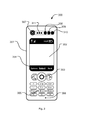
- FIG. 3 shows a mobile phone in where the present invention and all its variations can be embodied.
- the mobile phone 300 comprises of a casing 301, a display area 302, and means 303 for navigating among items displayed in the display area (not shown) and entering text and numbers 305 into the mobile phone.
- the display area may or may not be touch sensitive and it may comprise status indication areas and/or softkey bars 304.
- the display area 302, and the items displayed on it, may be operable using the navigation means 303 or, if using a touch sensitive screen, by tapping the on it with a pen-like object or a finger.
- the mobile phone 101 may also comprise other elements normally present in such devices, a speaker 311, a microphone 306, a camera 307, a photo sensor (e.g.
- ambient light 309
- a infrared light (IR) sensor infrared light emitting diode (IR LED) 310 a pressure sensor 308, processing means, memory means, one or more accelerometers, a vibration device, an AM/FM radio transmitter and receiver, a digital audio broadcast transmitter and receiver, a GPS device, an INS device, a Bluetooth device, a WiFi device, a near field communication device, an antenna module, an communication interface used for connecting external units extending the mobile phones capabilities.
- IR infrared light
- IR LED infrared light emitting diode
- processing means memory means, one or more accelerometers, a vibration device, an AM/FM radio transmitter and receiver, a digital audio broadcast transmitter and receiver, a GPS device, an INS device, a Bluetooth device, a WiFi device, a near field communication device, an antenna module, an communication interface used for connecting external units extending the mobile phones capabilities.
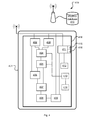
- Figure 4 shows a block diagram of an apparatus 418 for updating application information 412 (i.e. air pressure at sea level) of an application (i.e. altimeter application) in a mobile phone 401.
- the apparatus is comprised of a first determining unit 402 for determine the current location of the mobile phone 401 and a second determining unit 403 for determine the connectivity to a communication network 419 for the current location of the mobile phone 401.
- a compiler 404 is configured to adaptively create a visitation history 405 stored in the apparatus 418. The visitation history may be based on the following parameters the current location, the current connectivity, on previously visited locations, and on the connectivity of the previously visited locations.
- a prediction unit 406 configured to predict the next location the mobile phone will arrive at, based on the determined current location 402 and the visitation history 405.
- a third determining unit 407 is configured to determine, based on the visitation history 405, if the predicted next location 406 is likely to provide connectivity to a communication network 419 or not.
- a decision unit 408 is then configured to initiate a downloading, in a downloading unit 409 configured to download information from a server 410 on the communication network 419, if the next location is determined to likely not provide any connectivity to the communication network 419.
- An updating unit 411 is then adapted to update the application information 412 in the mobile phone 401 with the downloaded information.
- the apparatus 418 may in a variant also have a fourth determining unit 413 configured to determine if the application has been executed in the mobile phone 401 at the current location.
- the compiler 404 in the apparatus 418 may further be configured to base the creation of the visitation history 405 on if the application has previously been executed in the mobile phone 401 at the current location or at the previously visited locations.
- the apparatus 418 may in a variant further comprise a fifth determining unit 414 configured to determine if the application have been executed at the next location determined to have no connectivity to a communication network 419 and wherein the decision unit 408 is further configured to download information from the server 410 on the communication network 419, if the next location is determined to provide no connectivity to the communication network 419 and if the application is determined 414 to have been used, at the next location determined to have no connectivity to a communication network 419, then the updating unit 411 configured to update the application information 412 in the mobile phone401 with the downloaded information.
- a fifth determining unit 414 configured to determine if the application have been executed at the next location determined to have no connectivity to a communication network 419 and wherein the decision unit 408 is further configured to download information from the server 410 on the communication network 419, if the next location is determined to provide no connectivity to the communication network 419 and if the application is determined 414 to have been used, at the next location determined to have no connectivity to a communication network 419, then
- the updating unit 411 in the apparatus 418 may in a variant further comprises a comparing unit 415 configured to compare the application information 412 with the downloaded information and a replacing unit 416 configured to replace the application information 415 with the downloaded information if the application information 415 is older than the downloaded information.
- the determining of the current location in the first determining unit 402 may in a variant be performed by either Enhanced Observed Time Difference of a network cell or by determining the position of the portable communication device using a global positioning system, or both.
- Embodiments of the present invention have been exemplified using a portable communication device such as a mobile phone.
- a portable communication device such as a mobile phone.
- the invention is as such equally applicable to electronic devices which have wired- and/or wireless radio communication capabilities. Examples of such devices may for instance be any type of mobile phone, laptops (such as standard, ultra portables, netbooks, and micro laptops), handheld computers, PDAs, gaming devices, pads, accessories to mobile phones, etc.
- laptops such as standard, ultra portables, netbooks, and micro laptops
- handheld computers PDAs
- gaming devices pads, accessories to mobile phones, etc.
- the embodiments outlined in this specification are exemplified with and related to mobile phones only.
- the embodiments and the variations of the embodiment described above all have targeted a mobile phone with a pressure sensor running an altimeter application.
- the basic invention terrorism may be generalized and extended to many different applications and functions in a portable communication device, for example to a ambient light sensor and the downloading of UV indexes for different locations, etc.
Landscapes
- Physics & Mathematics (AREA)
- Engineering & Computer Science (AREA)
- General Physics & Mathematics (AREA)
- Radar, Positioning & Navigation (AREA)
- Remote Sensing (AREA)
- Mobile Radio Communication Systems (AREA)
Priority Applications (2)
| Application Number | Priority Date | Filing Date | Title |
|---|---|---|---|
| EP11163043A EP2515075A1 (fr) | 2011-04-19 | 2011-04-19 | Prédiction du temps pour capteur de pression |
| US13/357,748 US20120270566A1 (en) | 2011-04-19 | 2012-01-25 | Weather prediction for pressure sensor |
Applications Claiming Priority (1)
| Application Number | Priority Date | Filing Date | Title |
|---|---|---|---|
| EP11163043A EP2515075A1 (fr) | 2011-04-19 | 2011-04-19 | Prédiction du temps pour capteur de pression |
Publications (1)
| Publication Number | Publication Date |
|---|---|
| EP2515075A1 true EP2515075A1 (fr) | 2012-10-24 |
Family
ID=44583630
Family Applications (1)
| Application Number | Title | Priority Date | Filing Date |
|---|---|---|---|
| EP11163043A Withdrawn EP2515075A1 (fr) | 2011-04-19 | 2011-04-19 | Prédiction du temps pour capteur de pression |
Country Status (2)
| Country | Link |
|---|---|
| US (1) | US20120270566A1 (fr) |
| EP (1) | EP2515075A1 (fr) |
Families Citing this family (7)
| Publication number | Priority date | Publication date | Assignee | Title |
|---|---|---|---|---|
| US9255813B2 (en) * | 2011-10-14 | 2016-02-09 | Microsoft Technology Licensing, Llc | User controlled real object disappearance in a mixed reality display |
| US9913239B2 (en) * | 2012-03-09 | 2018-03-06 | Qualcomm Incorporated | Method and system for determining location of mobile devices in a femtocell |
| KR101366015B1 (ko) * | 2012-07-06 | 2014-02-24 | 한국전자통신연구원 | 고도 측정이 가능한 휴대 단말 및 이를 이용한 고도 측정 방법 |
| JP6079183B2 (ja) * | 2012-12-05 | 2017-02-15 | 富士通株式会社 | 情報処理装置、通信端末、アプリケーション提供方法、アプリケーション実行方法、アプリケーション提供プログラム、及びアプリケーション実行プログラム |
| US9772428B2 (en) * | 2013-06-18 | 2017-09-26 | Google Technology Holdings LLC | Determining micro-climates based on weather-related sensor data from mobile devices |
| US10088601B2 (en) * | 2014-10-28 | 2018-10-02 | Google Llc | Weather forecasting using satellite data and mobile-sensor data from mobile devices |
| EP3314286B1 (fr) * | 2015-06-29 | 2022-03-09 | HERE Global B.V. | Annonce d'informations relatives à la pression ambiante |
Citations (6)
| Publication number | Priority date | Publication date | Assignee | Title |
|---|---|---|---|---|
| US20020090976A1 (en) * | 2000-10-13 | 2002-07-11 | David Chatain | Mobile telecommunications terminals |
| US20050170848A1 (en) * | 2002-10-08 | 2005-08-04 | Junichi Sato | Terminal apparatus and information acquiring system |
| US20080132249A1 (en) * | 2006-12-05 | 2008-06-05 | Palm, Inc. | Local caching of map data based on carrier coverage data |
| US20090247137A1 (en) * | 2008-03-31 | 2009-10-01 | Mina Awad | Potential call drop indicator |
| US20110029670A1 (en) * | 2009-07-31 | 2011-02-03 | Microsoft Corporation | Adapting pushed content delivery based on predictiveness |
| US20110060807A1 (en) * | 2009-09-10 | 2011-03-10 | John Jeffrey Martin | System and method for tracking user location and associated activity and responsively providing mobile device updates |
Family Cites Families (3)
| Publication number | Priority date | Publication date | Assignee | Title |
|---|---|---|---|---|
| US8290513B2 (en) * | 2007-06-28 | 2012-10-16 | Apple Inc. | Location-based services |
| US8457653B2 (en) * | 2011-02-25 | 2013-06-04 | Nokia Corporation | Method and apparatus for pre-fetching location-based data while maintaining user privacy |
| US20120278172A1 (en) * | 2011-04-26 | 2012-11-01 | Microsoft Corporation | Delivering location-based offers based on consumer characteristics |
-
2011
- 2011-04-19 EP EP11163043A patent/EP2515075A1/fr not_active Withdrawn
-
2012
- 2012-01-25 US US13/357,748 patent/US20120270566A1/en not_active Abandoned
Patent Citations (6)
| Publication number | Priority date | Publication date | Assignee | Title |
|---|---|---|---|---|
| US20020090976A1 (en) * | 2000-10-13 | 2002-07-11 | David Chatain | Mobile telecommunications terminals |
| US20050170848A1 (en) * | 2002-10-08 | 2005-08-04 | Junichi Sato | Terminal apparatus and information acquiring system |
| US20080132249A1 (en) * | 2006-12-05 | 2008-06-05 | Palm, Inc. | Local caching of map data based on carrier coverage data |
| US20090247137A1 (en) * | 2008-03-31 | 2009-10-01 | Mina Awad | Potential call drop indicator |
| US20110029670A1 (en) * | 2009-07-31 | 2011-02-03 | Microsoft Corporation | Adapting pushed content delivery based on predictiveness |
| US20110060807A1 (en) * | 2009-09-10 | 2011-03-10 | John Jeffrey Martin | System and method for tracking user location and associated activity and responsively providing mobile device updates |
Also Published As
| Publication number | Publication date |
|---|---|
| US20120270566A1 (en) | 2012-10-25 |
Similar Documents
| Publication | Publication Date | Title |
|---|---|---|
| CN113739784B (zh) | 定位方法、用户设备、存储介质和电子设备 | |
| US9980246B2 (en) | Systems and methods for using three-dimensional location information to improve location services | |
| US20120270566A1 (en) | Weather prediction for pressure sensor | |
| KR102035771B1 (ko) | 휴대용 단말기에서 위치 정보를 보상하기 위한 장치 및 방법 | |
| US8180379B2 (en) | Synchronizing mobile and vehicle devices | |
| KR102103170B1 (ko) | 모바일 디바이스의 위치정보 제공 방법 및 장치 | |
| CN102753992B (zh) | 基于轨迹的位置确定 | |
| US8630798B2 (en) | Electronic system and method for personal navigation | |
| EP2976658B1 (fr) | Procédés et appareils d'initialisation de capteur déclenché par positionnement | |
| US8972180B1 (en) | Method and apparatus for managing multiple sensors in a navigation system | |
| CN113295174B (zh) | 一种车道级定位的方法、相关装置、设备以及存储介质 | |
| US20150264534A1 (en) | Method and apparatus for adaptive positioning | |
| EP2502089A2 (fr) | Détermination de position en utilisant un signal sans fil | |
| CN113167907A (zh) | 基于姿态数据的位置确定方法以及设备 | |
| US10993204B2 (en) | Systems and methods for determining if a receiver is inside or outside a building or area | |
| WO2019120195A1 (fr) | Système de navigation d'intérieur faisant appel à des capteurs inertiels et à un dispositif à faible énergie de courte longueur d'onde | |
| CN103718062A (zh) | 用于确保个人导航设备的服务的持续性的方法及其设备 | |
| EP3440448B1 (fr) | Étalonnage automatique de sortie de capteur de pression pour détermination fiable d'altitude | |
| KR20130116151A (ko) | 보폭 추정 모델 파라미터를 이용한 보행자 위치 추정 방법 및 이를 위한 장치 | |
| EP4402432A1 (fr) | Étalonnage de capteurs de pressions barométriques à base de dispositifs | |
| US20050131639A1 (en) | Methods, systems, and media for providing a location-based service | |
| TWI631359B (zh) | 電子裝置以及用於提供位置資訊的方法 | |
| KR20210018002A (ko) | 캐리어 부착형 제어장치 및 이를 포함하는 스마트 캐리어 | |
| HK40049430A (en) | A method, related devices, equipment and storage medium of lane-level positioning | |
| HK40049430B (en) | A method, related devices, equipment and storage medium of lane-level positioning |
Legal Events
| Date | Code | Title | Description |
|---|---|---|---|
| PUAI | Public reference made under article 153(3) epc to a published international application that has entered the european phase |
Free format text: ORIGINAL CODE: 0009012 |
|
| AK | Designated contracting states |
Kind code of ref document: A1 Designated state(s): AL AT BE BG CH CY CZ DE DK EE ES FI FR GB GR HR HU IE IS IT LI LT LU LV MC MK MT NL NO PL PT RO RS SE SI SK SM TR |
|
| AX | Request for extension of the european patent |
Extension state: BA ME |
|
| STAA | Information on the status of an ep patent application or granted ep patent |
Free format text: STATUS: THE APPLICATION IS DEEMED TO BE WITHDRAWN |
|
| 18D | Application deemed to be withdrawn |
Effective date: 20130425 |