EP2525239B1 - Vorrichtung und Verfahren zum Ausgleichen von Positionsinformation in tragbaren Endgeräten - Google Patents
Vorrichtung und Verfahren zum Ausgleichen von Positionsinformation in tragbaren Endgeräten Download PDFInfo
- Publication number
- EP2525239B1 EP2525239B1 EP12162084.3A EP12162084A EP2525239B1 EP 2525239 B1 EP2525239 B1 EP 2525239B1 EP 12162084 A EP12162084 A EP 12162084A EP 2525239 B1 EP2525239 B1 EP 2525239B1
- Authority
- EP
- European Patent Office
- Prior art keywords
- position information
- portable terminal
- estimated
- information
- estimation error
- Prior art date
- Legal status (The legal status is an assumption and is not a legal conclusion. Google has not performed a legal analysis and makes no representation as to the accuracy of the status listed.)
- Active
Links
Images



Classifications
-
- G—PHYSICS
- G01—MEASURING; TESTING
- G01S—RADIO DIRECTION-FINDING; RADIO NAVIGATION; DETERMINING DISTANCE OR VELOCITY BY USE OF RADIO WAVES; LOCATING OR PRESENCE-DETECTING BY USE OF THE REFLECTION OR RERADIATION OF RADIO WAVES; ANALOGOUS ARRANGEMENTS USING OTHER WAVES
- G01S19/00—Satellite radio beacon positioning systems; Determining position, velocity or attitude using signals transmitted by such systems
- G01S19/38—Determining a navigation solution using signals transmitted by a satellite radio beacon positioning system
- G01S19/39—Determining a navigation solution using signals transmitted by a satellite radio beacon positioning system the satellite radio beacon positioning system transmitting time-stamped messages, e.g. GPS [Global Positioning System], GLONASS [Global Orbiting Navigation Satellite System] or GALILEO
- G01S19/42—Determining position
- G01S19/48—Determining position by combining or switching between position solutions derived from the satellite radio beacon positioning system and position solutions derived from a further system
- G01S19/49—Determining position by combining or switching between position solutions derived from the satellite radio beacon positioning system and position solutions derived from a further system whereby the further system is an inertial position system, e.g. loosely-coupled
-
- G—PHYSICS
- G01—MEASURING; TESTING
- G01C—MEASURING DISTANCES, LEVELS OR BEARINGS; SURVEYING; NAVIGATION; GYROSCOPIC INSTRUMENTS; PHOTOGRAMMETRY OR VIDEOGRAMMETRY
- G01C21/00—Navigation; Navigational instruments not provided for in groups G01C1/00 - G01C19/00
- G01C21/26—Navigation; Navigational instruments not provided for in groups G01C1/00 - G01C19/00 specially adapted for navigation in a road network
- G01C21/28—Navigation; Navigational instruments not provided for in groups G01C1/00 - G01C19/00 specially adapted for navigation in a road network with correlation of data from several navigational instruments
- G01C21/30—Map- or contour-matching
Definitions
- the present invention relates generally to an apparatus and a method for compensating position information of a portable terminal.
- the portable terminal can provide a service for searching desired establishments and attraction near the currently located area. Also, using the position information of the portable terminal, it is possible to locate a friend or a user himself/herself, or to efficiently arrange and manage workers and vehicles. Further, using the position information of the portable terminal, a service can be implemented to inform a guardian of a child of current position or a moving path of the child or an object.
- the portable terminal typically estimates the position information using a Global Navigation Satellite System (GNSS) and a triangulation.
- GNSS Global Navigation Satellite System
- the portable terminal can estimate its position information by measuring a phase of a satellite signal sent from a GNSS satellite, or by estimating a code of the satellite code and measuring a distance to the satellite.
- the portable terminal using the GNSS cannot receive the accurate satellite signal in a shadow zone of the satellite signal, for example, inside a building or in built-up areas, and thus cannot accurately estimate its position.
- WO2008140144 discloses a method of correcting a map matching and a navigation system for implementing the method arc provided.
- the method includes: determining whether a vehicle turns by using an acceleration sensor; and performing a map matching correction by using the determination of whether the vehicle turns and Global Positioning System (GPS) information.
- GPS Global Positioning System
- US2007/005243 discloses a location-centric signal shadow mapping and storing architecture that creates maps where signals, such as GPS, cannot be seen with ease because of natural or synthetic features such as groups of tall buildings. Such maps are used with other information, such as the dynamics of the sensed velocity that had been seen before the loss of the signals, to reason about the location and likely activities being carried out by one or more people. Inferences can be made based on information about organizations and services associated with structures and locations proximal to the locations where signals were lost. Also, such reasoning can be used to turn off or to reduce the power consumed by the receivers of the location information, potentially with the joint use of accelerometers to identify when significant accelerations occur.
- WO200239063 discloses a map aided positioning system for a movable object wherein digital map information and information from stale characteristic sensors of the movable object is used in a filtering procedure that based on an initial position indication repeatedly during the movement of the movable object calculates position estimate candidates and a continuously improved position estimate.
- the present invention addresses the above-discussed deficiencies of the prior art by providing an improved way of estimating the position information of a portable terminal.
- Another aspect of the present invention is to provide an apparatus and a method for estimating the position information of a portable terminal in a GNSS shadow zone.
- Yet another aspect of the present invention is to provide an apparatus and a method for compensating for an estimation error of the position information of a portable terminal using motion information of the portable terminal.
- Still another aspect of the present invention is to provide an apparatus and a method for compensating for an estimation error of the position information of a portable terminal using motion information of the portable terminal and map mapping scheme.
- a further aspect of the present invention is to provide an apparatus and a method for compensating for an estimation error of the position information estimated in a GNSS shadow zone using motion information of the portable terminal.
- a further aspect of the present invention is to provide an apparatus and a method for compensating for an estimation error of the position information estimated in a GNSS shadow zone using motion information of the portable terminal and map mapping scheme.
- a method for estimating position information in a portable terminal is defined in claim 1.
- an apparatus for estimating position information in a portable terminal is defined in claim 10.
- Exemplary embodiments of the present invention provide a technique for compensating an estimation error of the position information in a portable terminal.
- the portable terminal represents small terminals capable of estimating its position, and embraces a mobile communication terminal, a Personal Data Assistant (PDA), an MP3 player, a navigation device, and a portable computer.
- PDA Personal Data Assistant
- MP3 player an MP3 player
- navigation device an MP3 player
- portable computer a portable computer
- a mobile communication terminal compensates an estimation error of the position information.
- other portable terminals mentioned above can compensate the estimation error of the position information according to the teachings of the present invention..
- the portable terminal can estimate the using Global Navigation Satellite System (GNSS), triangulation, and position recognition using a beacon signal.
- GNSS Global Navigation Satellite System
- triangulation triangulation
- position recognition using a beacon signal.
- the portable terminal selectively compensates the position information estimated using the GPS. For example, when the accurate position information can be estimated using the GPS, the portable terminal estimates the position information only using the GPS. However, when the accurate position information cannot be estimated using the GPS, the portable terminal compensates the estimation error of the position information estimated using the GPS by identifying GPS shadow zones based on a simplified map of GPS shadow zones, as shown in FIG. 1 .
- the GPS shadow zone indicates a region where the portable terminal cannot receive the accurate satellite signal because of at least one of multipath, signal attenuation, and signal interference.
- FIG. 1 depicts the GPS shadow zones according to an exemplary embodiment of the present invention.
- a server 100 stores map information representing the GPS shadow zones 110 through 118.
- the server 100 also has map information including road and building information of the GPS shadow zones 110 through 118. It is appreciated by those skilled in the art that map information of road and structures defining a specific zone is well known in the art, thus a discussion thereof is omitted. Note that the server 110 is updated with the latest geographical information for any changes in the road, buildings, and structure that would interfere with the reception of GPS signals.
- the server 100 transmits the map information indicating the GPS shadow zones to the portable terminal according to a request of the portable terminal.
- FIG. 2 is a block diagram of a portable terminal according to an exemplary embodiment of the present invention.
- the portable terminal includes a controller 200, a position compensator 202, a position estimator 210, a sensing module 220, a storage unit 230, an input unit 240, a display unit 250, a communication module 260, and an audio processor 270.
- the controller 200 controls overall operations of the portable terminal.
- the controller 200 determines whether to compensate for the estimation error of the position information estimated by the position estimator 210. For example, the controller 200 determines whether the portable terminal lies in the GPS shadow zone using the position information provided from the position estimator 210. When the portable terminal is in the GPS shadow zone, the controller 200 controls a position compensator 202 to compensate the estimation error of the position information provided from the position estimator 210. When the portable terminal does not travel within or through the GPS shadow zone, the controller 200 recognizes that the estimation error of the position information provided from the position estimator 210 is not compensated.
- the controller 200 uses the position information provided from the position estimator 210 to provide a Location Based Service (LBS) of the portable terminal.
- LBS Location Based Service
- the controller 200 uses the position information provided from the position estimator 210 to compensate for the estimation error of the position information to provide the LBS of the potable terminal using the position information of the estimation error compensated by the position compensator 202.
- the position compensator 202 compensates the error in the position information provided from the position estimator 210 using sensing data output from the sensing module 220 and the map data of the travel region of the portable terminal.
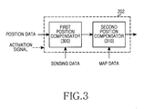
- the position compensator 202 is constructed as shown in FIG. 3 .
- the sensing data indicates motion state information of the portable terminal detected by the sensing module 220.
- the position estimator 210 estimates the position of the portable terminal using a satellite signal sent from a GPS satellite.
- the sensing module 220 detects the motion state of the portable terminal. To this end, the sensing module 220 includes at least one of an acceleration sensor, a geomagnetic sensor, a gyroscope sensor, and an altitude sensor.
- the storage unit 230 can include a program storage for storing a program to control the operations of the portable terminal, and a data storage for storing data generating in the program execution.
- the storage unit 230 stores the map information indicating the GPS shadow zones.
- the controller 200 receives the map indicating the GPS shadow zones from a server and stores the map it in the storage unit 230.
- the controller 200 receives the map data for the map mapping from a server, and stores the received map data to the storage unit 230.
- the map indicating the GPS shadow zones can be generated as shown in FIG. 1 .
- the map data indicates the detailed map data or the simplified map data to indicate the travel path of the terminal.
- the input unit 240 provides input data generated by the user's selection to the controller 200.
- the display unit 250 displays status information, a menu screen, and story information of the portable terminal under the control of the controller 200.
- the display unit 250 includes a touch screen.
- the communication module 260 processes voice and data communication signals transmitted and received via an antenna.
- the audio processor 270 processes an audio signal input and output through the portable terminal.
- FIG. 3 is a detailed block diagram of the position compensator of the portable terminal according to an exemplary embodiment of the present invention.
- the position compensator 202 includes a first position compensator 300 and a second position compensator 310.
- the position compensator 202 operates only to compensate the estimation error of the position information that is estimated by the position estimator 210 under the control of the controller 200.
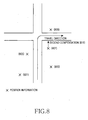
- the first position compensator 300 firstly compensates the estimation error in the position information estimated by the position estimator 210 using the sensing data provided from the sensing module 220. For example, a plurality of GPS points 801, 803, and 805 can be identified according to the multi-path in a downtown area near the concentrated tall building as shown in FIG. 8 .
- the first position compensator 300 firstly compensates the estimation error by selecting any one of the GPS points 801, 803 and 805 based on a previous position of the terminal. That is, selection of one correct GPS point is correct determination of position (location) of the portable terminal.
- a plurality of GPS points 805, 807, and 809 can be identified according to the multi-path in the downtown area near the concentrated tall building as shown in FIG. 8 .
- the first position compensator 300 can select only the GPS points 807 and 809 on the travel direction (the right side) of the portable terminal based on the motion of the portable terminal.
- the second position compensator 310 secondarily compensates the estimation error of the position information by matching the firstly compensated position information output from the first position compensator 300, to the map. For example, from the GPS points 805, 807, and 809 estimated by the position estimator 210, the first position compensator 300 can select the GPS point 807 according to the travel direction (the right side) of the portable terminal. In so doing, the second position compensator 310 secondarily compensates 810 the estimation error of the position information by matching the selected GPS point 807 to the map.
- the portable terminal has GPS shadow zone information.
- the portable terminal downloads the simplified map data including the GPS shadow zone information from a separate server, as shown in FIG. 1 .
- FIG. 4 illustrates a method for compensating the position information in the portable terminal according to one exemplary embodiment of the present invention.
- the portable terminal estimates its position in step 401. That is, the portable terminal estimates its position using the satellite signal received from the GPS satellite.
- step 403 the portable terminal determines whether it has the map data of the travel region of the portable terminal.
- the portable terminal When having the map data, the portable terminal firstly compensates the estimation error of the position information estimated in step 401, using the sensing data indicating the motion state of the portable terminal in step 405. For example, when the plurality of the GPS points is currently estimated from the satellite signal as shown in FIG. 8 , the portable terminal selects some of the estimated GPS points according to the motion of the portable terminal determined according to the sensing data. That is, selection of correct GPS point is correct determination of position (location) of the portable terminal.
- the portable terminal downloads the map data of its travel region from the separate server in step 411.
- the map data includes any one of the detailed map data including building and road information to guide the path, and the simplified map data including only the simplified road data to compensate for the estimation error alone of the position information.
- the portable terminal firstly compensates the estimation error of the position information estimated in step 401, using the sensing data indicating the motion state of the portable terminal.
- a plurality of GPS points 801, 803, and 805 can be identified according to the multi-path in a downtown area near the concentrated tall building as shown in FIG. 8 .
- the portable terminal firstly compensates the estimation error by selecting any one of the GPS points 801, 803 and 805 using the sensing data. That is, selection of one correct GPS point is correct determination of position (location) of the portable terminal.
- the portable terminal secondarily compensates for the estimation error of the position information by matching the firstly compensated position information to the map data. For example, when selecting the GPS point 807 according to the first compensation as shown in FIG. 8 , the portable terminal matches the GPS point 807 to the road through the second compensation 810.
- step 409 the portable terminal stores the secondarily compensated position information as its position information.
- the portable terminal provides the LBS such as path guide and position determine, using the stored position information.
- the portable terminal compensates for the estimation error of the position information estimated by the position estimator 210 using the motion information of the portable terminal and the map mapping.
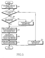
- the portable terminal may selectively compensate for the estimation error of the position information according to reliability of the position information estimated by the position estimator 210 as shown in FIG. 5 .
- FIG. 5 illustrates a method for compensating the position information of the portable terminal according to another exemplary embodiment of the present invention.
- the portable terminal estimates its position. For example, the portable terminal estimates its position using the satellite signal received from the GPS satellite.
- step 503 the portable terminal determines whether it travels in the GPS shadow zone by taking account of the estimated position information.
- the portable terminal When not traveling in the GPS shadow zone, the portable terminal recognizes that the position information estimated in step 501 is reliable. Hence, the portable terminal stores the position information estimated in step 501 as its position in step 515. In so doing, the portable terminal provides the LBS, such as path guide and position determine, using the stored position information.
- the portable terminal recognizes that the position information estimated in step 501 is not reliable. In step 505, the portable terminal determines whether it has the map data of its travel region.
- the portable terminal When having the map data, the portable terminal firstly compensates for the estimation error of the position information estimated in step 501 using the sensing data indicating its motion information in step 507. For example, when the plurality of the GPS points is currently estimated from the satellite signal as shown in FIG. 8 , the portable terminal selects some of the estimated GPS points according to the motion of the portable terminal determined according to the sensing data. That is, selection of some correct GPS point is correct determination of position (location) of the portable terminal.
- the portable terminal downloads the map data including its travel region from the separate server in step 513.
- the map data includes any one of the detailed map data including the building and road information to guide the path, and the simplified map data including only the simplified road data to compensate for the estimation error alone of the position information.
- step 507 the portable terminal firstly compensates the estimation error of the position information estimated in step 501, using the sensing data indicating the motion state of the portable terminal in step 507.
- the portable terminal secondarily compensates for the estimation error of the position information by matching the firstly compensated position information to the map data. For example, when selecting the GPS point 807 according to the first compensation as shown in FIG. 8 , the portable terminal matches the GPS point 807 to the road through the second compensation 810.
- the portable terminal stores the secondarily compensated position information as its position information.
- the portable terminal provides the LBS such as path guide and position determine, using the stored position information.
- the portable terminal compensates the estimation error of the position information estimated by the position estimator 210 only in the GPS shadow zone.
- the portable terminal can compensate for the estimation error of the position information estimated by the position estimator 210 even at a certain distance near the GPS shadow zone.
- the portable terminal may compensate for the estimation error of the position information estimated by the position estimator 210 even when determining the movement into the GPS shadow zone by considering its travel direction.
- the portable terminal After estimating the position of the portable terminal in FIGS. 4 and 5 , the portable terminal determines whether there is the map data of its travel region. In so doing, after estimating the position, the portable terminal can determine the map data at any point before the second compensation through the map matching.
- the portable terminal has the GPS shadow zone information.
- the portable terminal downloads the simplified map data including the GPS shadow zone information of FIG. 1 from the separate server.
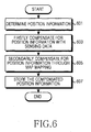
- FIG. 6 illustrates a method for compensating for the position information in the portable terminal according to yet another exemplary embodiment of the present invention.
- the portable terminal estimates its position. For example, the portable terminal estimates its position using the satellite signal received from the GPS satellite.
- step 603 the portable terminal firstly compensates for the estimation error of the position information estimated in step 601, using the sensing data indicating the motion state of the portable terminal. For example, when the plurality of the GPS points is currently estimated from the satellite signal, the portable terminal selects some of the estimated GPS points according to the motion of the portable terminal determined according to the sensing data.
- step 605 the portable terminal secondarily compensates for the estimation error of the position information by matching the firstly compensated position information to the map data. For example, when selecting the GPS point 807 according to the first compensation as shown in FIG. 8 , the portable terminal matches the GPS point 807 to the road through the second compensation 810.
- step 607 the portable terminal stores the secondarily compensated position information as its position information.
- the portable terminal provides the LBS such as path guide and position determine, using the stored position information.
- the portable terminal compensates for the estimation error of the position information estimated by the position estimator 210 using the motion information of the portable terminal and the map mapping.
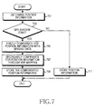
- the portable terminal may selectively compensate for the estimation error of the position information according to the reliability of the position information estimated by the position estimator 210 as shown in FIG. 7 .
- FIG. 7 illustrates a method for compensating for the position information in the portable terminal according to still yet another exemplary embodiment of the present invention.
- the portable terminal estimates its position. For example, the portable terminal estimates its position using the satellite signal received from the GPS satellite.
- step 703 the portable terminal determines whether it travels in the GPS shadow zone by taking account of the estimated position information.
- the portable terminal When not traveling in the GPS shadow zone, the portable terminal recognizes that the position information estimated in step 701 is reliable. Hence, the portable terminal stores the position information estimated in step 701 as its position in step 715. In so doing, the portable terminal provides the LBS, such as path guide and position determine, using the stored position information.
- the portable terminal recognizes that the position information estimated in step 701 is not reliable.
- the portable terminal firstly compensates for the estimation error of the position information estimated in step 701 using the sensing data indicating its motion state. For example, when the plurality of the GPS points is currently estimated from the satellite signal as shown in FIG. 8 , the portable terminal selects some of the estimated GPS points according to the motion of the portable terminal determined according to the sensing data.
- step 707 the portable terminal secondarily compensates for the estimation error of the position information by matching the firstly compensated position information to the map data. For example, when selecting the GPS point 807 according to the first compensation as shown in FIG. 8 , the portable terminal matches the GPS point 807 to the road through the second compensation 810.
- step 709 the portable terminal stores the secondarily compensated position information as its position information.
- the portable terminal provides the LBS such as path guide and position determine, using the stored position information.
- the portable terminal compensates for the estimation error of the position information estimated by the position estimator 210 only in the GPS shadow zone.
- the portable terminal can compensate for the estimation error of the position information estimated by the position estimator 210 even at a certain distance near the GPS shadow zone.
- the portable terminal may compensate for the estimation error of the position information estimated by the position estimator 210 even when determining the movement into the GPS shadow zone by considering its travel direction.
- the portable terminal compensates for the position information estimated through the position estimation scheme, using the sensing data and the map matching.
- the portable terminal may estimate its position using merely the sensing data.
- the accurate position information can be estimated.
- the estimation error of the position information is compensated using the map mapping merely with the simplified map information, memory waste in storing the map information can be reduced.
- the above-described methods according to the present invention can be implemented in hardware, firmware or as software or computer code that can be stored in a recording medium such as a CD ROM, an RAM, a floppy disk, a hard disk, or a magneto-optical disk or computer code downloaded over a network originally stored on a remote recording medium or a non-transitory machine readable medium and to be stored on a local recording medium, so that the methods described herein can be rendered in such software that is stored on the recording medium using a general purpose computer, or a special processor or in programmable or dedicated hardware, such as an ASIC or FPGA.
- a recording medium such as a CD ROM, an RAM, a floppy disk, a hard disk, or a magneto-optical disk or computer code downloaded over a network originally stored on a remote recording medium or a non-transitory machine readable medium and to be stored on a local recording medium, so that the methods described herein can be rendered in such software that is stored on the recording medium using a
- the computer, the processor, microprocessor controller or the programmable hardware include memory components, e.g., RAM, ROM, Flash, etc. that may store or receive software or computer code that when accessed and executed by the computer, processor or hardware implement the processing methods described herein.
- memory components e.g., RAM, ROM, Flash, etc.
- the execution of the code transforms the general purpose computer into a special purpose computer for executing the processing shown herein.
Landscapes
- Engineering & Computer Science (AREA)
- Radar, Positioning & Navigation (AREA)
- Remote Sensing (AREA)
- Physics & Mathematics (AREA)
- General Physics & Mathematics (AREA)
- Computer Networks & Wireless Communication (AREA)
- Automation & Control Theory (AREA)
- Navigation (AREA)
Claims (15)
- Verfahren zum Abschätzen von Positionsangaben in einem tragbaren Endgerät, das Folgendes umfasst:Abschätzen (401) von Positionsangaben des tragbaren Endgerätes;erstens (405) Kompensieren eines Abschätzungsfehlers der abgeschätzten Positionsangaben durch Betrachten von Bewegungsangaben des tragbaren Endgerätes;zweitens (407) Kompensieren des Abschätzungsfehlers der erstens kompensierten Positionsangaben gemäß einem Kartenabstimmungsmodell undSpeichern (409) der Positionsangaben des kompensierten Abschätzungsfehlers als die Positionsangaben des tragbaren Endgerätes.
- Verfahren nach Anspruch 1, das ferner Folgendes umfasst:nach Abschätzen (501) der Positionsangaben Bestimmen (503) der Zuverlässigkeit der abgeschätzten Positionsangaben,wobei, wenn die Positionsangaben unzuverlässig sind, der Abschätzungsfehler der abgeschätzten Positionsangaben kompensiert wird (507).
- Verfahren nach Anspruch 2, wobei das Bestimmen der Zuverlässigkeit Folgendes umfasst:Bestimmen von GNSS-Abschattungszonenangaben;Bestimmen (503), ob das tragbare Endgerät eine GNSS-Abschattungszone durchläuft, durch Betrachten der abgeschätzten Positionsangaben und,wenn das tragbare Endgerät die GNSS-Abschattungszone durchläuft, Bestimmen, dass die abgeschätzten Positionsangaben unzuverlässig sind.
- Verfahren nach Anspruch 2, das ferner Folgendes umfasst:wenn die Positionsangaben zuverlässig sind, Speichern (515) der abgeschätzten Positionsangaben als die Positionsangaben des tragbaren Endgerätes.
- Verfahren nach Anspruch 3, das ferner Folgendes umfasst:Bereitstellen eines ortsbezogenen Dienstes (LBS) unter Verwendung der gespeicherten Positionsangaben.
- Verfahren nach Anspruch 1, das ferner Folgendes umfasst:nach Abschätzen der Positionsangaben Bestimmen, ob Kartendaten eines Reisegebietes des tragbaren Endgerätes beinhaltet sind, und,wenn die Kartendaten nicht beinhaltet sind, Herunterladen (513) der Kartendaten des Reisegebietes des tragbaren Endgerätes von einem Server,wobei das zweitens Kompensieren (509) sekundäres Kompensieren (605) des Abschätzungsfehlers der Positionsangaben durch Abbilden der erstens kompensierten Positionsangaben auf die heruntergeladenen Kartendaten gemäß dem Kartenabbildungsmodell umfasst.
- Verfahren nach Anspruch 1, das ferner Folgendes umfasst:Bereitstellen eines ortsbezogenen Dienstes (LBS) unter Verwendung der gespeicherten Positionsangaben.
- Verfahren nach Anspruch 1, wobei das Positionsabschätzungsmodell mindestens eines von einem Global-Navigation-Satellite-System-Modell (GNSS-Modell), einem Triangulationsmodell und einem Positionserkennungsmodell unter Verwendung eines Funkfeuers umfasst.
- Verfahren nach Anspruch 1, wobei die Bewegungsangaben des tragbaren Endgerätes über ein Erfassungsmodul bestimmt werden, das mindestens einen von einem Beschleunigungssensor, einem erdmagnetischen Sensor, einem Kreiselsensor und einem Höhensensor umfasst.
- Vorrichtung zum Abschätzen von Positionsangaben in einem tragbaren Endgerät, die Folgendes umfasst:einen Positionsschätzer (210) zum Abschätzen von Positionsangaben des tragbaren Endgerätes;ein Erfassungsmodul (220) zum Erfassen von Bewegungsangaben des tragbaren Endgerätes;einen Positionskompensator (202) zum erstens Kompensieren eines Abschätzungsfehlers der Positionsangaben, die durch den Positionsschätzer abgeschätzt wurden, durch Betrachten der Bewegungsangaben des tragbaren Endgerätes, die durch das Erfassungsmodul erfasst wurden, und zweitens Kompensieren des Abschätzungsfehlers der kompensierten Positionsangaben gemäß einem Kartenabbildungsmodell undeine Speichereinheit (230) zum Speichern der Positionsangaben, die durch den Positionskompensator kompensiert wurden, als die Positionsangaben des tragbaren Endgerätes.
- Vorrichtung nach Anspruch 10, die ferner Folgendes umfasst:eine Steuerung (200) zum Bestimmen der Zuverlässigkeit der Positionsangaben, die durch den Positionsschätzer abgeschätzt wurden, und Steuern, um den Abschätzungsfehler der Positionsangaben zu kompensieren, die durch den Positionsschätzer abgeschätzt wurden, wenn die Positionsangaben unzuverlässig sind.
- Vorrichtung nach Anspruch 11, wobei das Bestimmen der Zuverlässigkeit Folgendes umfasst:Bestimmen von GNSS-Abschattungszonenangaben;Bestimmen, ob das tragbare Endgerät eine GNSS-Abschattungszone durchläuft, durch Betrachten der abgeschätzten Positionsangaben und,wenn das tragbare Endgerät die GNSS-Abschattungszone durchläuft, Bestimmen, dass die abgeschätzten Positionsangaben unzuverlässig sind.
- Vorrichtung nach Anspruch 11, die ferner Folgendes umfasst:wenn die Positionsangaben zuverlässig sind, Speichern der abgeschätzten Positionsangaben als die Positionsangaben des tragbaren Endgerätes.
- Vorrichtung nach Anspruch 13, wobei, wenn Kartendaten eines Reisegebietes des tragbaren Endgerätes beinhaltet sind, die Steuerung die Kartendaten des Reisegebietes des tragbaren Endgerätes von einem Server (100) herunterlädt.
- Vorrichtung nach Anspruch 30, die ferner Folgendes umfasst:eine Steuerung zum Bereitstellen eines ortsbezogenen Dienstes (LBS) unter Verwendung der Positionsangaben, die in der Speichereinheit gespeichert sind.
Applications Claiming Priority (1)
| Application Number | Priority Date | Filing Date | Title |
|---|---|---|---|
| KR20110047824 | 2011-05-20 |
Publications (2)
| Publication Number | Publication Date |
|---|---|
| EP2525239A1 EP2525239A1 (de) | 2012-11-21 |
| EP2525239B1 true EP2525239B1 (de) | 2014-12-17 |
Family
ID=46196981
Family Applications (1)
| Application Number | Title | Priority Date | Filing Date |
|---|---|---|---|
| EP12162084.3A Active EP2525239B1 (de) | 2011-05-20 | 2012-03-29 | Vorrichtung und Verfahren zum Ausgleichen von Positionsinformation in tragbaren Endgeräten |
Country Status (1)
| Country | Link |
|---|---|
| EP (1) | EP2525239B1 (de) |
Family Cites Families (3)
| Publication number | Priority date | Publication date | Assignee | Title |
|---|---|---|---|---|
| SE0004096D0 (sv) * | 2000-11-08 | 2000-11-08 | Nira Automotive Ab | Positioning system |
| US7647171B2 (en) * | 2005-06-29 | 2010-01-12 | Microsoft Corporation | Learning, storing, analyzing, and reasoning about the loss of location-identifying signals |
| KR20090001721A (ko) * | 2007-05-14 | 2009-01-09 | 팅크웨어(주) | 맵 매칭 보정 방법 및 상기 방법을 수행하는 내비게이션시스템 |
-
2012
- 2012-03-29 EP EP12162084.3A patent/EP2525239B1/de active Active
Also Published As
| Publication number | Publication date |
|---|---|
| EP2525239A1 (de) | 2012-11-21 |
Similar Documents
| Publication | Publication Date | Title |
|---|---|---|
| US8589070B2 (en) | Apparatus and method for compensating position information in portable terminal | |
| EP3338105B1 (de) | Verfahren zur beschleunigungsmessergestützten navigation | |
| EP3114435B1 (de) | Reduzierter leistungsverbrauch und verbesserte benutzererfahrung bei der navigation entlang vertrauter strecken | |
| US9151635B2 (en) | Route search apparatus, route search method, and program | |
| US9677887B2 (en) | Estimating an initial position and navigation state using vehicle odometry | |
| CN102112891B (zh) | 稳健位置估计 | |
| EP2372306B1 (de) | Verfahren und vorrichtung zur effizienten nutzung eines akkus in einem smartphone mit navigationssystem | |
| JP5648447B2 (ja) | 周遊ルート生成装置、周遊ルート生成方法、及びプログラム | |
| US10641612B2 (en) | Method and apparatus for correcting current position in navigation system via human-machine interface | |
| JP6024366B2 (ja) | 情報処置装置および処理方法 | |
| US20110213550A1 (en) | Navigation system | |
| JP5109817B2 (ja) | 携帯端末、ナビゲーション方法、及びナビゲーション用プログラム | |
| JP2011141131A (ja) | ナビゲーション装置、ナビゲーション方法、およびプログラム | |
| EP3440448B1 (de) | Automatische drucksensorausgangskalibrierung zur zuverlässigen höhenbestimmung | |
| EP3372958B1 (de) | Navigationsverfahren und navigationsvorrichtung | |
| WO2014002782A1 (ja) | 移動端末、システム及び方法 | |
| JP5693527B2 (ja) | ナビゲーション装置、ナビゲーションシステム、ナビゲーション方法およびナビゲーションプログラム | |
| KR101673749B1 (ko) | 지향성 통신을 이용한 측위 시스템 및 그 방법 | |
| KR20130002086A (ko) | 오차 보정을 통한 추측항법 시스템 및 그 방법 | |
| JP2007256041A (ja) | Gps測位による位置算出装置 | |
| JP2016206017A (ja) | 電子機器、及び移動速度算出プログラム | |
| EP2525239B1 (de) | Vorrichtung und Verfahren zum Ausgleichen von Positionsinformation in tragbaren Endgeräten | |
| JP2005016955A (ja) | 車載用ナビゲーション装置及び車載用ナビゲーション装置の測位方法 | |
| JP2015190871A (ja) | ナビゲーション装置、及びフリー状態判定方法 | |
| JP2007024701A (ja) | ナビゲーション装置 |
Legal Events
| Date | Code | Title | Description |
|---|---|---|---|
| PUAI | Public reference made under article 153(3) epc to a published international application that has entered the european phase |
Free format text: ORIGINAL CODE: 0009012 |
|
| AK | Designated contracting states |
Kind code of ref document: A1 Designated state(s): AL AT BE BG CH CY CZ DE DK EE ES FI FR GB GR HR HU IE IS IT LI LT LU LV MC MK MT NL NO PL PT RO RS SE SI SK SM TR |
|
| AX | Request for extension of the european patent |
Extension state: BA ME |
|
| 17P | Request for examination filed |
Effective date: 20130521 |
|
| 17Q | First examination report despatched |
Effective date: 20131220 |
|
| GRAP | Despatch of communication of intention to grant a patent |
Free format text: ORIGINAL CODE: EPIDOSNIGR1 |
|
| INTG | Intention to grant announced |
Effective date: 20140714 |
|
| GRAS | Grant fee paid |
Free format text: ORIGINAL CODE: EPIDOSNIGR3 |
|
| GRAA | (expected) grant |
Free format text: ORIGINAL CODE: 0009210 |
|
| AK | Designated contracting states |
Kind code of ref document: B1 Designated state(s): AL AT BE BG CH CY CZ DE DK EE ES FI FR GB GR HR HU IE IS IT LI LT LU LV MC MK MT NL NO PL PT RO RS SE SI SK SM TR |
|
| REG | Reference to a national code |
Ref country code: GB Ref legal event code: FG4D |
|
| REG | Reference to a national code |
Ref country code: CH Ref legal event code: EP |
|
| REG | Reference to a national code |
Ref country code: IE Ref legal event code: FG4D |
|
| REG | Reference to a national code |
Ref country code: AT Ref legal event code: REF Ref document number: 702298 Country of ref document: AT Kind code of ref document: T Effective date: 20150115 |
|
| REG | Reference to a national code |
Ref country code: DE Ref legal event code: R096 Ref document number: 602012004292 Country of ref document: DE Effective date: 20150129 |
|
| REG | Reference to a national code |
Ref country code: NL Ref legal event code: T3 |
|
| PG25 | Lapsed in a contracting state [announced via postgrant information from national office to epo] |
Ref country code: NO Free format text: LAPSE BECAUSE OF FAILURE TO SUBMIT A TRANSLATION OF THE DESCRIPTION OR TO PAY THE FEE WITHIN THE PRESCRIBED TIME-LIMIT Effective date: 20150317 Ref country code: LT Free format text: LAPSE BECAUSE OF FAILURE TO SUBMIT A TRANSLATION OF THE DESCRIPTION OR TO PAY THE FEE WITHIN THE PRESCRIBED TIME-LIMIT Effective date: 20141217 Ref country code: FI Free format text: LAPSE BECAUSE OF FAILURE TO SUBMIT A TRANSLATION OF THE DESCRIPTION OR TO PAY THE FEE WITHIN THE PRESCRIBED TIME-LIMIT Effective date: 20141217 |
|
| REG | Reference to a national code |
Ref country code: LT Ref legal event code: MG4D |
|
| PG25 | Lapsed in a contracting state [announced via postgrant information from national office to epo] |
Ref country code: SE Free format text: LAPSE BECAUSE OF FAILURE TO SUBMIT A TRANSLATION OF THE DESCRIPTION OR TO PAY THE FEE WITHIN THE PRESCRIBED TIME-LIMIT Effective date: 20141217 Ref country code: GR Free format text: LAPSE BECAUSE OF FAILURE TO SUBMIT A TRANSLATION OF THE DESCRIPTION OR TO PAY THE FEE WITHIN THE PRESCRIBED TIME-LIMIT Effective date: 20150318 Ref country code: HR Free format text: LAPSE BECAUSE OF FAILURE TO SUBMIT A TRANSLATION OF THE DESCRIPTION OR TO PAY THE FEE WITHIN THE PRESCRIBED TIME-LIMIT Effective date: 20141217 Ref country code: LV Free format text: LAPSE BECAUSE OF FAILURE TO SUBMIT A TRANSLATION OF THE DESCRIPTION OR TO PAY THE FEE WITHIN THE PRESCRIBED TIME-LIMIT Effective date: 20141217 Ref country code: RS Free format text: LAPSE BECAUSE OF FAILURE TO SUBMIT A TRANSLATION OF THE DESCRIPTION OR TO PAY THE FEE WITHIN THE PRESCRIBED TIME-LIMIT Effective date: 20141217 |
|
| REG | Reference to a national code |
Ref country code: AT Ref legal event code: MK05 Ref document number: 702298 Country of ref document: AT Kind code of ref document: T Effective date: 20141217 |
|
| PG25 | Lapsed in a contracting state [announced via postgrant information from national office to epo] |
Ref country code: CZ Free format text: LAPSE BECAUSE OF FAILURE TO SUBMIT A TRANSLATION OF THE DESCRIPTION OR TO PAY THE FEE WITHIN THE PRESCRIBED TIME-LIMIT Effective date: 20141217 Ref country code: RO Free format text: LAPSE BECAUSE OF FAILURE TO SUBMIT A TRANSLATION OF THE DESCRIPTION OR TO PAY THE FEE WITHIN THE PRESCRIBED TIME-LIMIT Effective date: 20141217 Ref country code: ES Free format text: LAPSE BECAUSE OF FAILURE TO SUBMIT A TRANSLATION OF THE DESCRIPTION OR TO PAY THE FEE WITHIN THE PRESCRIBED TIME-LIMIT Effective date: 20141217 Ref country code: EE Free format text: LAPSE BECAUSE OF FAILURE TO SUBMIT A TRANSLATION OF THE DESCRIPTION OR TO PAY THE FEE WITHIN THE PRESCRIBED TIME-LIMIT Effective date: 20141217 Ref country code: SK Free format text: LAPSE BECAUSE OF FAILURE TO SUBMIT A TRANSLATION OF THE DESCRIPTION OR TO PAY THE FEE WITHIN THE PRESCRIBED TIME-LIMIT Effective date: 20141217 |
|
| PG25 | Lapsed in a contracting state [announced via postgrant information from national office to epo] |
Ref country code: IS Free format text: LAPSE BECAUSE OF FAILURE TO SUBMIT A TRANSLATION OF THE DESCRIPTION OR TO PAY THE FEE WITHIN THE PRESCRIBED TIME-LIMIT Effective date: 20150417 Ref country code: PL Free format text: LAPSE BECAUSE OF FAILURE TO SUBMIT A TRANSLATION OF THE DESCRIPTION OR TO PAY THE FEE WITHIN THE PRESCRIBED TIME-LIMIT Effective date: 20141217 Ref country code: AT Free format text: LAPSE BECAUSE OF FAILURE TO SUBMIT A TRANSLATION OF THE DESCRIPTION OR TO PAY THE FEE WITHIN THE PRESCRIBED TIME-LIMIT Effective date: 20141217 |
|
| REG | Reference to a national code |
Ref country code: DE Ref legal event code: R097 Ref document number: 602012004292 Country of ref document: DE |
|
| PLBE | No opposition filed within time limit |
Free format text: ORIGINAL CODE: 0009261 |
|
| STAA | Information on the status of an ep patent application or granted ep patent |
Free format text: STATUS: NO OPPOSITION FILED WITHIN TIME LIMIT |
|
| PG25 | Lapsed in a contracting state [announced via postgrant information from national office to epo] |
Ref country code: DK Free format text: LAPSE BECAUSE OF FAILURE TO SUBMIT A TRANSLATION OF THE DESCRIPTION OR TO PAY THE FEE WITHIN THE PRESCRIBED TIME-LIMIT Effective date: 20141217 Ref country code: MC Free format text: LAPSE BECAUSE OF FAILURE TO SUBMIT A TRANSLATION OF THE DESCRIPTION OR TO PAY THE FEE WITHIN THE PRESCRIBED TIME-LIMIT Effective date: 20141217 Ref country code: LU Free format text: LAPSE BECAUSE OF FAILURE TO SUBMIT A TRANSLATION OF THE DESCRIPTION OR TO PAY THE FEE WITHIN THE PRESCRIBED TIME-LIMIT Effective date: 20150329 |
|
| REG | Reference to a national code |
Ref country code: CH Ref legal event code: PL |
|
| 26N | No opposition filed |
Effective date: 20150918 |
|
| PG25 | Lapsed in a contracting state [announced via postgrant information from national office to epo] |
Ref country code: IT Free format text: LAPSE BECAUSE OF FAILURE TO SUBMIT A TRANSLATION OF THE DESCRIPTION OR TO PAY THE FEE WITHIN THE PRESCRIBED TIME-LIMIT Effective date: 20141217 |
|
| REG | Reference to a national code |
Ref country code: FR Ref legal event code: ST Effective date: 20151130 |
|
| REG | Reference to a national code |
Ref country code: IE Ref legal event code: MM4A |
|
| PG25 | Lapsed in a contracting state [announced via postgrant information from national office to epo] |
Ref country code: IE Free format text: LAPSE BECAUSE OF NON-PAYMENT OF DUE FEES Effective date: 20150329 Ref country code: CH Free format text: LAPSE BECAUSE OF NON-PAYMENT OF DUE FEES Effective date: 20150331 Ref country code: LI Free format text: LAPSE BECAUSE OF NON-PAYMENT OF DUE FEES Effective date: 20150331 |
|
| PG25 | Lapsed in a contracting state [announced via postgrant information from national office to epo] |
Ref country code: SI Free format text: LAPSE BECAUSE OF FAILURE TO SUBMIT A TRANSLATION OF THE DESCRIPTION OR TO PAY THE FEE WITHIN THE PRESCRIBED TIME-LIMIT Effective date: 20141217 Ref country code: FR Free format text: LAPSE BECAUSE OF NON-PAYMENT OF DUE FEES Effective date: 20150331 |
|
| PG25 | Lapsed in a contracting state [announced via postgrant information from national office to epo] |
Ref country code: BE Free format text: LAPSE BECAUSE OF FAILURE TO SUBMIT A TRANSLATION OF THE DESCRIPTION OR TO PAY THE FEE WITHIN THE PRESCRIBED TIME-LIMIT Effective date: 20141217 |
|
| PG25 | Lapsed in a contracting state [announced via postgrant information from national office to epo] |
Ref country code: MT Free format text: LAPSE BECAUSE OF FAILURE TO SUBMIT A TRANSLATION OF THE DESCRIPTION OR TO PAY THE FEE WITHIN THE PRESCRIBED TIME-LIMIT Effective date: 20141217 |
|
| PG25 | Lapsed in a contracting state [announced via postgrant information from national office to epo] |
Ref country code: SM Free format text: LAPSE BECAUSE OF FAILURE TO SUBMIT A TRANSLATION OF THE DESCRIPTION OR TO PAY THE FEE WITHIN THE PRESCRIBED TIME-LIMIT Effective date: 20141217 Ref country code: BG Free format text: LAPSE BECAUSE OF FAILURE TO SUBMIT A TRANSLATION OF THE DESCRIPTION OR TO PAY THE FEE WITHIN THE PRESCRIBED TIME-LIMIT Effective date: 20141217 Ref country code: HU Free format text: LAPSE BECAUSE OF FAILURE TO SUBMIT A TRANSLATION OF THE DESCRIPTION OR TO PAY THE FEE WITHIN THE PRESCRIBED TIME-LIMIT; INVALID AB INITIO Effective date: 20120329 |
|
| PG25 | Lapsed in a contracting state [announced via postgrant information from national office to epo] |
Ref country code: CY Free format text: LAPSE BECAUSE OF FAILURE TO SUBMIT A TRANSLATION OF THE DESCRIPTION OR TO PAY THE FEE WITHIN THE PRESCRIBED TIME-LIMIT Effective date: 20141217 |
|
| PG25 | Lapsed in a contracting state [announced via postgrant information from national office to epo] |
Ref country code: PT Free format text: LAPSE BECAUSE OF FAILURE TO SUBMIT A TRANSLATION OF THE DESCRIPTION OR TO PAY THE FEE WITHIN THE PRESCRIBED TIME-LIMIT Effective date: 20150417 |
|
| PG25 | Lapsed in a contracting state [announced via postgrant information from national office to epo] |
Ref country code: TR Free format text: LAPSE BECAUSE OF FAILURE TO SUBMIT A TRANSLATION OF THE DESCRIPTION OR TO PAY THE FEE WITHIN THE PRESCRIBED TIME-LIMIT Effective date: 20141217 |
|
| PG25 | Lapsed in a contracting state [announced via postgrant information from national office to epo] |
Ref country code: MK Free format text: LAPSE BECAUSE OF FAILURE TO SUBMIT A TRANSLATION OF THE DESCRIPTION OR TO PAY THE FEE WITHIN THE PRESCRIBED TIME-LIMIT Effective date: 20141217 |
|
| PG25 | Lapsed in a contracting state [announced via postgrant information from national office to epo] |
Ref country code: AL Free format text: LAPSE BECAUSE OF FAILURE TO SUBMIT A TRANSLATION OF THE DESCRIPTION OR TO PAY THE FEE WITHIN THE PRESCRIBED TIME-LIMIT Effective date: 20141217 |
|
| PGFP | Annual fee paid to national office [announced via postgrant information from national office to epo] |
Ref country code: NL Payment date: 20220222 Year of fee payment: 11 |
|
| REG | Reference to a national code |
Ref country code: NL Ref legal event code: MM Effective date: 20230401 |
|
| PG25 | Lapsed in a contracting state [announced via postgrant information from national office to epo] |
Ref country code: NL Free format text: LAPSE BECAUSE OF NON-PAYMENT OF DUE FEES Effective date: 20230401 |
|
| PGFP | Annual fee paid to national office [announced via postgrant information from national office to epo] |
Ref country code: GB Payment date: 20260224 Year of fee payment: 15 |
|
| PGFP | Annual fee paid to national office [announced via postgrant information from national office to epo] |
Ref country code: DE Payment date: 20260220 Year of fee payment: 15 |