EP2533015B1 - Procédés et systèmes pour afficher des informations de procédure sur un écran d'avion - Google Patents
Procédés et systèmes pour afficher des informations de procédure sur un écran d'avion Download PDFInfo
- Publication number
- EP2533015B1 EP2533015B1 EP12168590.3A EP12168590A EP2533015B1 EP 2533015 B1 EP2533015 B1 EP 2533015B1 EP 12168590 A EP12168590 A EP 12168590A EP 2533015 B1 EP2533015 B1 EP 2533015B1
- Authority
- EP
- European Patent Office
- Prior art keywords
- aircraft
- information
- navigational
- displayed
- textual
- Prior art date
- Legal status (The legal status is an assumption and is not a legal conclusion. Google has not performed a legal analysis and makes no representation as to the accuracy of the status listed.)
- Active
Links
Images


Classifications
-
- G—PHYSICS
- G01—MEASURING; TESTING
- G01C—MEASURING DISTANCES, LEVELS OR BEARINGS; SURVEYING; NAVIGATION; GYROSCOPIC INSTRUMENTS; PHOTOGRAMMETRY OR VIDEOGRAMMETRY
- G01C23/00—Combined instruments indicating more than one navigational value, e.g. for aircraft; Combined measuring devices for measuring two or more variables of movement, e.g. distance, speed or acceleration
-
- G—PHYSICS
- G08—SIGNALLING
- G08G—TRAFFIC CONTROL SYSTEMS
- G08G5/00—Traffic control systems for aircraft
- G08G5/20—Arrangements for acquiring, generating, sharing or displaying traffic information
- G08G5/21—Arrangements for acquiring, generating, sharing or displaying traffic information located onboard the aircraft
-
- G—PHYSICS
- G08—SIGNALLING
- G08G—TRAFFIC CONTROL SYSTEMS
- G08G5/00—Traffic control systems for aircraft
- G08G5/20—Arrangements for acquiring, generating, sharing or displaying traffic information
- G08G5/26—Transmission of traffic-related information between aircraft and ground stations
-
- G—PHYSICS
- G08—SIGNALLING
- G08G—TRAFFIC CONTROL SYSTEMS
- G08G5/00—Traffic control systems for aircraft
- G08G5/50—Navigation or guidance aids
- G08G5/54—Navigation or guidance aids for approach or landing
Definitions
- the subject matter described herein relates generally to avionics systems, and more particularly, embodiments of the subject matter relate to displaying content on a display associated with an aircraft.
- Electronic displays in many modern flight deck displays are eliminating the need to maintain paper charts for the various procedures that a pilot may need to execute.
- the size of the electronic display inside an aircraft cockpit is often limited due to the number of instruments and human-machine interface elements inside the cockpit (e.g., joysticks, knobs, buttons, and the like) along with the need for the pilot to have an unobstructed view outside the aircraft.
- some of the display area on the electronic display may be utilized or reserved for other processes (e.g., primary flight displays, synthetic vision displays, vertical situation displays, flight management windows, and the like).
- EP2253938A1 discloses methods and systems for presenting information on a display device associated with an aircraft.
- a method comprises displaying a navigational map in a viewing area on the display device with initial display settings, identifying selection of a first category of information, and identifying content associated with the first category resulting in a first set of content.
- the method further comprises automatically updating display settings for the navigational map in response to identifying selection of the first category, wherein the display settings are updated based on the first set of content.
- the method further comprises displaying the first set of content on the navigational map (400) based on the updated display settings (210).
- the present invention provides a method for presenting information on a display device associated with an aircraft, according to claim 1 of the appended claims.
- the invention further provides a system according to claim 8 of the appended claims.
- Embodiments of the subject matter described herein relate to displaying aircraft procedure information prescribing operation of an aircraft on a display device.
- the aircraft procedure information for the appropriate procedure includes one or more symbolic elements and textual information associated with the respective symbolic element(s), wherein the combination of symbolic elements and textual information define the manner in which the aircraft is to be operated when executing that procedure.
- the symbolic elements of the aircraft procedure are displayed at their appropriate geographic locations overlying a navigational map.
- An amount (or quantity) of the textual information associated with the displayed symbolic elements that is to be displayed on the navigational map is determined based on one or more display settings for the navigational map and information indicative of the current and/or instantaneous aircraft operating state (e.g., flight phase, location, altitude, and/or the like). That determined amount of the textual information is then displayed overlying the navigational map proximate to or otherwise in association with the displayed symbolic elements.
- the navigational map is dynamically updated as the aircraft travels, such that the amount of textual information displayed on the navigational map increases and/or decreases in a manner that is influenced by the operation of the aircraft.
- the amount of textual information displayed on the navigational map is increased and/or decreased based on the new display setting(s).
- the textual information may be categorized and/or prioritized in a manner such that the higher priority textual information is displayed preferentially to lower priority textual information.
- the higher priority (or most relevant) textual information is reliably displayed on the navigational map and without being obscured and/or obfuscated by lower priority (or less relevant) information, while the lower priority (or less relevant) textual information is added and/or removed from the navigational map based on the most recently obtained status information for the aircraft to supplement the higher priority textual information when that lower priority textual information is relevant to the current operation of the aircraft.
- FIG. 1 depicts an exemplary embodiment of a system 100 which may be utilized with a vehicle, such as an aircraft 120.
- the system 100 includes, without limitation, a display device 102, a user input device 104, a processing system 106, a display system 108, a communications system 110, a navigation system 112, a flight management system (FMS) 114, one or more avionics systems 116, and a data storage element 118 suitably configured to support operation of the system 100, as described in greater detail below.
- FMS flight management system
- the display device 102 is realized as an electronic display capable of graphically displaying flight information or other data associated with operation of the aircraft 120 under control of the display system 108 and/or processing system 106.
- the display device 102 is coupled to the display system 108 and the processing system 106, wherein the processing system 106 and the display system 108 are cooperatively configured to display, render, or otherwise convey one or more graphical representations or images associated with operation of the aircraft 120 on the display device 102, as described in greater detail below.
- the user input device 104 is coupled to the processing system 106, and the user input device 104 and the processing system 106 are cooperatively configured to allow a user (e.g., a pilot, co-pilot, or crew member) to interact with the display device 102 and/or other elements of the system 100, as described in greater detail below.
- a user e.g., a pilot, co-pilot, or crew member
- the user input device 104 may be realized as a keypad, touchpad, keyboard, mouse, touch panel (or touchscreen), joystick, knob, line select key or another suitable device adapted to receive input from a user.
- the user input device 104 is realized as an audio input device, such as a microphone, audio transducer, audio sensor, or the like, that is adapted to allow a user to provide audio input to the system 100 in a "hands free” manner without requiring the user to move his or her hands, eyes and/or head to interact with the system 100.
- an audio input device such as a microphone, audio transducer, audio sensor, or the like, that is adapted to allow a user to provide audio input to the system 100 in a "hands free” manner without requiring the user to move his or her hands, eyes and/or head to interact with the system 100.
- the processing system 106 generally represents the hardware, software, and/or firmware components configured to facilitate communications and/or interaction between the elements of the system 100 and perform additional tasks and/or functions to support operation of the system 100, as described in greater detail below.
- the processing system 106 may be implemented or realized with a general purpose processor, a content addressable memory, a digital signal processor, an application specific integrated circuit, a field programmable gate array, any suitable programmable logic device, discrete gate or transistor logic, processing core, discrete hardware components, or any combination thereof, designed to perform the functions described herein.
- the processing system 106 may also be implemented as a combination of computing devices, e.g., a plurality of processing cores, a combination of a digital signal processor and a microprocessor, a plurality of microprocessors, one or more microprocessors in conjunction with a digital signal processor core, or any other such configuration.
- the processing system 106 includes processing logic that may be configured to carry out the functions, techniques, and processing tasks associated with the operation of the system 100, as described in greater detail below.
- the steps of a method or algorithm described in connection with the embodiments disclosed herein may be embodied directly in hardware, in firmware, in a software module executed by the processing system 106, or in any practical combination thereof.
- the processing system 106 may implement a speech recognition engine (or voice recognition engine) and/or speech-to-text system adapted to receive audio input from a user.
- the processing system 106 may also include one or more analog-to-digital converters (ADCs), digital-to-analog converters (DACs), analog filters and/or digital filters suitably configured to support operations of the system 100.
- ADCs analog-to-digital converters
- DACs digital-to-analog converters
- analog filters and/or digital filters suitably configured to support operations of the system 100.
- the display system 108 generally represents the hardware, software, and/or firmware components configured to control the display and/or rendering of one or more navigational maps and/or other displays pertaining to operation of the aircraft 120 and/or systems 110, 112, 114, 116 on the display device 102.
- the display system 108 may access or include one or more databases suitably configured to support operations of the display system 108, such as, for example, a terrain database, an obstacle database, a navigational database, a geopolitical database, a terminal airspace database, a special use airspace database, or other information for rendering and/or displaying navigational maps and/or other content on the display device 102.
- the processing system 106 includes or otherwise accesses data storage element 118, which contains aircraft procedure information (or instrument procedure information) for a plurality of airports and maintains the association of the aircraft procedure information and the corresponding airport.
- aircraft procedure information should be understood as a set of operating parameters or instructions associated with a particular aircraft action (e.g., approach, departure, arrival, climbing, and the like) that may be undertaken by the aircraft 120 at or in the vicinity of a particular airport.
- the aircraft procedure information for a particular aircraft action includes graphic elements (e.g., symbols for navigational reference points, navigational segments, procedure turns, and the like) that graphically illustrate that aircraft action and textual information associated with the graphic elements that further describe the operating parameters or instructions for executing that aircraft action.
- graphic elements e.g., symbols for navigational reference points, navigational segments, procedure turns, and the like
- an instrument approach procedure for an airport may include symbols and navigational segments that graphically illustrate the approach course along with procedure turns for transitioning to/from the approach course, and additionally, the approach procedure includes textual information associated with the symbols and/or navigational segments that describe the operating parameters or provide instructions for operating the aircraft at or in the vicinity of those symbols and/or navigational segments.
- the data storage element 118 maintains priority criteria for the textual information associated with the graphic elements of an aircraft procedure (or instrument procedure).
- a graphic element of an aircraft procedure may include a number of different categories or types of textual information associated therewith.
- a symbol for a navigational reference point may have an associated name, designation for the type of position fix (e.g., initial approach fix, final approach fix, or the like), names of other navigational reference points and the distances to/from those other navigational reference points, a minimum altitude at that navigational reference point, and the like.
- a navigational segment may have an associated bearing (or heading), a minimum altitude, a distance (or length), and the like.
- each category or type of textual information may be assigned a priority criterion or value to facilitate identifying or otherwise determining a subset of the textual information for display on the display device 102 based on the relative priorities to ensure the most relevant textual information is displayed during operation of the aircraft 120.
- an airport should be understood as referring to a location suitable for landing (or arrival) and/or takeoff (or departure) of an aircraft, such as, for example, airports, runways, landing strips, and other suitable landing and/or departure locations
- an aircraft action should be understood as referring to an approach (or landing), an arrival, a departure (or takeoff), an ascent, taxiing, or another aircraft action having associated aircraft procedure information.
- Each airport may have one or more predefined aircraft procedures associated therewith, wherein the aircraft procedure information for each aircraft procedure at each respective airport may be maintained by the data storage element 118.
- the aircraft procedure information may be provided by or otherwise obtained from a governmental or regulatory organization, such as, for example, the Federal Aviation Administration in the United States.
- the aircraft procedure information comprises instrument procedure information, such as instrument approach procedures, standard terminal arrival routes, instrument departure procedures, standard instrument departure routes, obstacle departure procedures, or the like, traditionally displayed on a published charts, such as Instrument Approach Procedure (IAP) charts, Standard Terminal Arrival (STAR) charts or Terminal Arrival Area (TAA) charts, Standard Instrument Departure (SID) routes, Departure Procedures (DP), terminal procedures, approach plates, and the like.
- instrument procedure information such as instrument approach procedures, standard terminal arrival routes, instrument departure procedures, standard instrument departure routes, obstacle departure procedures, or the like, traditionally displayed on a published charts, such as Instrument Approach Procedure (IAP) charts, Standard Terminal Arrival (STAR) charts or Terminal Arrival Area (TAA) charts, Standard Instrument Departure (SID) routes, Departure Procedures (DP), terminal procedures, approach plates, and the like.
- IAP Instrument Approach Procedure
- STAR Standard Terminal Arrival
- TAA Terminal Arrival Area
- SID Standard Instrument Departure
- DP Departure Procedures
- terminal procedures approach plates, and the
- the processing system 106, the display system 108, and/or the FMS 114 are cooperatively configured to render and/or display aircraft procedure information overlying a navigational map on the display device 102, as described in greater detail below. It should be noted that although the subject matter is described below in the context of arrival procedures and/or approach procedures for purposes of explanation, the subject matter is not intended to be limited to use with any particular type of aircraft procedure and may be implemented for other aircraft procedures (e.g., departure procedures or en route procedures) in an equivalent manner.
- the processing system 106 is coupled to the navigation system 112, which is configured to provide real-time navigational data and/or information regarding operation of the aircraft 120.
- the navigation system 112 may be realized as a global positioning system (GPS), inertial reference system (IRS), or a radio-based navigation system (e.g., VHF omni-directional radio range (VOR) or long range aid to navigation (LORAN)), and may include one or more navigational radios or other sensors suitably configured to support operation of the navigation system 112, as will be appreciated in the art.
- GPS global positioning system
- IRS inertial reference system
- LORAN long range aid to navigation
- the navigation system 112 is capable of obtaining and/or determining the instantaneous position of the aircraft 120, that is, the current (or instantaneous) location of the aircraft 120 (e.g., the current latitude and longitude) and the current (or instantaneous) altitude or above ground level for the aircraft 120.
- the navigation system 112 is also capable of obtaining or otherwise determining the heading of the aircraft 120 (i.e., the direction the aircraft is traveling in relative to some reference).
- the processing system 106 is also coupled to the communications system 110, which is configured to support communications to and/or from the aircraft 120.
- the communications system 110 may support communications between the aircraft 120 and air traffic control or another suitable command center or ground location.
- the communications system 110 may be realized using a radio communication system or another suitable data link system.
- the processing system 106 is also coupled to the FMS 114, which is coupled to the navigation system 112, the communications system 110, and one or more additional avionics systems 116 to support navigation, flight planning, and other aircraft control functions in a conventional manner, as well as to provide real-time data and/or information regarding the operational status of the aircraft 120 to the processing system 106.
- FIG. 1 depicts a single avionics system 116, in practice, the system 100 and/or aircraft 120 will likely include numerous avionics systems for obtaining and/or providing real-time flight-related information that may be displayed on the display device 102 or otherwise provided to a user (e.g., a pilot, a co-pilot, or crew member).
- avionics systems suitably configured to support operation of the aircraft 120: a weather system, an air traffic management system, a radar system, a traffic avoidance system, an autopilot system, an autothrust system, a flight control system, hydraulics systems, pneumatics systems, environmental systems, electrical systems, engine systems, trim systems, lighting systems, crew alerting systems, electronic checklist systems, an electronic flight bag and/or another suitable avionics system.
- the FMS 114 (or another avionics system 116) is configured to determine, track, or otherwise identify the current flight phase of the aircraft 120.
- a flight phase of the aircraft 120 should be understood as a distinguishable segment of the operation (or distinguishable operating phase) of the aircraft 120 associated with traversing the aircraft 120 from a starting location to an ending location.
- operation of the aircraft 120 from a starting location (e.g., a terminal at a first airport) to an ending location (e.g., a terminal at a second airport) usually comprises a plurality of flight phases, such as, for example, a standing phase (e.g., when the aircraft is stationary on the ground), a pushback or towing phase (e.g., when the aircraft is moving on the ground with assistance), a taxiing phase, a takeoff phase, a climbing phase (e.g., including the initial climb and/or climb to cruise), a cruising phase, a descent phase (e.g., from cruise altitude to initial approach), an arrival phase, an approach phase, a landing phase, a rollout phase, and the like.
- a standing phase e.g., when the aircraft is stationary on the ground
- a pushback or towing phase e.g., when the aircraft is moving on the ground with assistance
- a taxiing phase e.g., a takeoff phase
- a climbing phase
- phases of flight are well known, and will not be described in detail herein. It should be noted that the phases of flight may be combined and/or categorized in numerous possible manners and/or each phase of flight may comprise numerous sub-phases (for example, an approach phase may include sub-phases for holding, procedure turn, flyover, orbit, and the like), and the subject matter is not intended to be limited to any particular number and/or classification of flight phases.
- FIG. 1 is a simplified representation of the system 100 for purposes of explanation and ease of description, and FIG. 1 is not intended to limit the application or scope of the subject matter described herein in any way.
- FIG. 1 shows the display device 102, the user input device 104, and the processing system 106 as being located onboard the aircraft 120 (e.g., in the cockpit), in practice, one or more of the display device 102, the user input device 104, and/or the processing system 106 may be located outside the aircraft 120 (e.g., on the ground as part of an air traffic control center or another command center) and communicatively coupled to the remaining elements of the system 100 (e.g., via a data link and/or communications system 110).
- the data storage element 118 may be located outside the aircraft 120 and communicatively coupled to the processing system 106 via a data link and/or communications system 110.
- practical embodiments of the system 100 and/or aircraft 120 will include numerous other devices and components for providing additional functions and features, as will be appreciated in the art.
- FIG. 1 shows a single display device 102, in practice, additional display devices may be present onboard the aircraft 120.
- features and/or functionality of processing system 106 described herein can be implemented by or otherwise integrated with the features and/or functionality provided by the display system 108 or the FMS 114. In other words, some embodiments may integrate the processing system 106 with the display system 108 or the FMS 114.
- the system 100 may be configured to perform a display process 200 and additional tasks, functions, and operations described below.
- the various tasks may be performed by hardware, firmware, software, or any combination thereof.
- the following description may refer to elements mentioned above in connection with FIG. 1 .
- the tasks, functions, and operations may be performed by different elements of the described system, such as the display device 102, the user input device 104, the processing system 106, the display system 108, the communications system 110, the navigation system 112, the FMS 114, the avionics system(s) 116, and/ or the data storage element 118.
- any number of additional or alternative tasks may be included, and may be incorporated into a more comprehensive procedure or process having additional functionality not described in detail herein.
- the display process 200 begins by rendering or otherwise displaying a navigational map relating to operation of an aircraft in a viewing area on a display device associated with the aircraft (task 202).
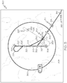
- the display system 108 and/or processing system 106 may display and/or render a navigational map 300 associated with the current (or instantaneous) location of the aircraft 120 on the display device 102 onboard the aircraft 120.
- a graphical representation 302 of the aircraft 120 is rendered and/or displayed on the map 300, and the graphical representation of the aircraft 302 is overlaid or rendered on top of a background 304.
- the background 304 comprises a graphical representation of the terrain, topology, or other suitable items or points of interest corresponding to (or within a given distance of) a location of the aircraft 120, which may be maintained (e.g., by the display system 108) in a terrain database, a navigational database, a geopolitical database, or another suitable database.
- the display system 108 may render a graphical representation of nearby navigational aids (e.g., VORs, VORTACs, DMEs, and the like) and airports overlying the background 304, including the airport 306 that the aircraft 120 is en route to.
- navigational map 300 may include graphical representations of airspace designations and/or airspace restrictions, cities, towns, roads, railroads, and other geo-political information.
- FIG. 3 depicts a top view (e.g., from above the aircraft 302) of the navigational map 300, in practice, alternative embodiments may utilize various perspective views, such as side views, three-dimensional views (e.g., a three-dimensional synthetic vision display), angular or skewed views, and the like.
- the navigational map 300 is associated with the movement of the aircraft 120, and the aircraft graphic 302 and/or background 304 refreshes or otherwise updates as the aircraft 120 travels, such that the graphical representation of the aircraft 302 is positioned over the terrain background 304 in a manner that accurately reflects the current (e.g., instantaneous or substantially real-time) real-world positioning of the aircraft 120 relative to the earth.
- the aircraft graphic 302 is shown as traveling across the navigational map 300 (e.g., by updating the location of the aircraft graphic 302 with respect to the background 304), while in other embodiments, the aircraft graphic 302 may be located at a fixed position on the navigational map 300 (e.g., by updating the background 304 with respect to the aircraft graphic 302 such that the map 300 is maintained centered on and/or aligned with the aircraft graphic 302).
- the aircraft graphic 302 is shown as traveling across the navigational map 300 (e.g., by updating the location of the aircraft graphic 302 with respect to the background 304), while in other embodiments, the aircraft graphic 302 may be located at a fixed position on the navigational map 300 (e.g., by updating the background 304 with respect to the aircraft graphic 302 such that the map 300 is maintained centered on and/or aligned with the aircraft graphic 302).
- the navigational map 300 is oriented north-up (i.e., moving upward on the map 300 corresponds to traveling northward), however, in alternative embodiments, the orientation of the navigational map 300 may be track-up or heading-up (i.e., aligned such that the aircraft graphic 302 is always traveling in an upward direction and the background 304 adjusted accordingly), as described in greater detail below.
- the display process 200 continues by rendering or otherwise displaying a graphical representation of one or more aircraft procedures on the navigational map (task 204).
- the aircraft procedure information for each aircraft procedure maintained by the data storage element 118 includes graphic elements (e.g., symbols, line segments, images, objects, or other graphical representations) that graphically illustrate one or more aspects of the aircraft procedure and textual information associated with the various graphic elements, wherein the combination of graphic elements and textual information prescribes the manner in which that particular aircraft action should be undertaken by the aircraft 120 at or in the vicinity of a particular airport.
- the display process 200 identifies the appropriate aircraft procedures for the aircraft 120 and displays the graphic elements for those identified aircraft procedures that are within the currently displayed area of the navigational map 300.
- the display process 200 may identify the appropriate aircraft procedure information to be displayed on the map 300 based on the flight plan maintained by the FMS 114.
- the flight plan maintained by the FMS 114 may specify airport 306 as the desired airport for landing the aircraft 120, along with the desired approach and/or arrival route for that airport.
- the display process 200 may identify airport 306 as a desired airport for landing the aircraft 120 based on airport 306 being the final entry (or destination) of a flight plan maintained by FMS 114, and then determine the desired approach and/or arrival route for airport 306 based on the current heading and/or location of the aircraft 120 (e.g., the approach and/or arrival route closest to the location of the aircraft 120 and/or most closely aligned with the current heading of the aircraft 120).
- the user may manipulate the user input device 104 to select or otherwise indicate the desired aircraft procedure information to be displayed for the airport 306.
- the illustrated embodiment of FIG. 3 reflects the navigational map 300 after the display process 200 identifies the "RYANN ONE" standard terminal arrival route as the desired arrival route for the airport 306 and the "ILS RWY 16R" instrument approach as the desired approach for the airport 306.
- the processing system 106 may identify the "RYANN ONE" standard terminal arrival route based on the flight plan maintained by the FMS 114, and then access the data storage element 118 to obtain information regarding the geographic locations of the graphic elements of the "RYANN ONE" standard terminal arrival route to determine which graphic elements are within the currently displayed area of the navigational map 300 and display those graphic elements at their appropriate geographic locations with respect to the background 304 and/or aircraft 302.
- the processing system 106 displays the symbol 310 for the navigational reference point RYANN and the symbol 312 for the navigational reference point MUSTANG at their appropriate geographic locations on the map 300 along with the navigational segment 314 delineating the flight path between the two reference points 310, 312.
- the processing system 106 may identify the "ILS RWY 16R" instrument approach as the desired approach based on the flight plan maintained by the FMS 114, and then access the data storage element 118 to obtain information regarding the geographic locations of the graphic elements of the "ILS RWY 16R" instrument approach to determine which graphic elements are within the currently displayed area of the navigational map 300 and display those graphic elements at their appropriate geographic locations with respect to the background 304 and/or aircraft 302.
- the processing system 106 displays the symbols 320, 322, 324, 326, 328, 330 for the navigational reference points of the ILS RWY 16R approach at their appropriate geographic locations on the map 300, such that each navigational reference point symbol 320, 322, 324, 326, 328, 330 is positioned overlying the background 304 in a manner that accurately reflects the real-world geographic location of its associated navigational reference point.
- the processing system 106 also displays the navigational segments 317, 319, 321, 323, 325, 327, 335 between navigational reference points, procedure turns 331, 333, and missed approach procedures 337 for the ILS RWY 16R approach, as illustrated in FIG. 3 and described in greater detail below.
- the display process 200 continues by obtaining current (or instantaneous) status information for the aircraft (task 206).
- the processing system 106 may obtain (e.g., from FMS 114, navigation system 112 and/or other avionic systems 116) one or more of the following: the current flight phase for the aircraft 120, the current location of the aircraft 120 (or a particular distance from a navigational reference point or a desired track), the current altitude (or above ground level) of the aircraft 120, and/or the current heading (or bearing) of the aircraft 120.
- the display process 200 continues by determining the amount of textual aircraft procedure information (e.g., the textual information associated with the symbolic elements of the aircraft procedures displayed within the map) that should be displayed on the navigational map based on the most recently obtained aircraft status, and displaying the determined amount of textual aircraft procedure information on the navigational map (tasks 208, 210).
- the processing system 106 determines the amount of textual aircraft procedure information to be displayed within the map 300 based on the current aircraft status, such that the textual aircraft procedure information most likely to be relevant is displayed while less relevant textual aircraft procedure information is not displayed.
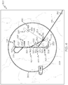
- the processing system 106 may obtain the current flight phase for the aircraft 120 from the FMS 114 and identify current flight phase as being the arrival phase. In other embodiments, the processing system 106 may obtain the current location of the aircraft 120 and determine that the aircraft 120 is in the arrival phase based on the current location of the aircraft 120 being south and/or east of the MUSTANG reference point 312.
- the processing system 106 determines that textual information 311, 313, 315 associated with the symbols 310, 312 and segment 314 of the arrival route procedure should be displayed on the map 300 and that textual information associated with the graphic elements of the approach procedure (e.g., symbols 320, 322, 324, 326, 328, 330 and navigational segments 317, 319, 321, 323, 325, 327, 335) should not be displayed on the map 300.
- the processing system 106 determines the arrival procedure information is more likely to be relevant than the approach procedure information due to the aircraft 120 being in the arrival phase.
- the display process 200 determines the amount of textual aircraft procedure information to be displayed based on one or more display settings for the navigational map 300.
- the display settings comprise one or more characteristics that control the manner in which the navigational map 300 appears on the display device 102, such as, for example, an orientation, a center location, and a range setting.
- the display process 200 determines the amount of textual aircraft procedure information to be displayed on the navigational map 300 based on the range setting, and increases and/or decreases that amount in response to changes in the range settings, as described in greater detail below.
- the range setting for the navigational map 300 corresponds to the field of view for the navigational map 300, that is, the amount of geographical area (e.g., terrain 304) displayed in the navigational map 300.
- the range setting for the navigational map 300 is inversely related to the scale of the navigational map 300, that is, the ratio of a single unit of distance on the map 300 to a corresponding distance on the ground. As such, a higher range setting corresponds to a lower scale (or a larger field of view) for the navigational map 300 while a lower range setting corresponds to a higher scale (or a smaller field of view) for the navigational map 300.
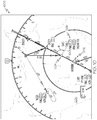
- the display system 108 may indicate the range setting for the navigational map 300 by displaying and/or rendering a range ring 350 on the navigational map 300.
- the range ring 350 comprises a circle that is always displayed with a fixed dimension and/or size on the navigational map 300 and indicates the range setting for the navigational map 300.
- the range setting is equal to the real-world distance that corresponds to (or is equivalent to) the radius of the range ring 350 based on the scale of the navigational map 300.
- the range ring 350 indicates that the radius of the circle defined by the range ring 350 corresponds to a distance of eighteen nautical miles. As described in greater detail below in the context of FIGS.
- the display process 200 determines that a greater amount of textual aircraft procedure information should be displayed on the navigational map 300. Conversely, at higher range settings, the display process 200 determines a lesser amount of textual aircraft procedure information should be displayed on the navigational map 300.
- the processing system 106 determines that only the highest priority textual information associated with the symbols 310, 312 should be displayed on the navigational map 300.
- the categories of textual information associated with the symbols 310, 312 may be assigned priority criterion, wherein the name (or identifier) category may assigned the highest priority value, resulting in the names of the reference points should be displayed proximate to or otherwise in association with the symbols 310, 312.
- the processing system 106 determines that the bearing information for the segment 314 (e.g., 299°) and the distance information for the segment 314 (e.g., 25 nautical miles) should be displayed on the navigational map 300 along the length of the segment 314. It should be noted that in some embodiments, when the range setting is greater (or the length of the navigational segment 314 decreases), the processing system 106 may determine that the textual information 311 associated with the navigational segment 314 should be displayed offset from the navigational segment 314, rather than along the length of the navigational segment 314, as described in greater detail below in the context of FIGS. 7-9 .
- the loop defined by tasks 206, 208 and 210 repeats throughout operation of the aircraft 120 to dynamically update the navigational map 300 to reflect the current operating status of the aircraft 120 (e.g., the most recently obtained location, heading, flight phase, and/or the like).
- the processing system 106 and/or display system 108 periodically updates the background 304 and/or aircraft 302 to reflect the real-world position of the aircraft 120 based on the most recently obtained location and/or heading information for the aircraft 120. As illustrated in FIG.
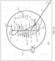
- the FMS 114 may indicate to the processing system 106 that the current flight phase for the aircraft 120 has changed from the arrival phase to the approach phase, or alternatively, the processing system 106 may determine that the aircraft 120 is in the approach phase based on the current location of the aircraft 120 as having passed the MUSTANG reference point (e.g., based on the current location of the aircraft 120 being west and/or north of the MUSTANG reference point).
- the processing system 106 determines that textual information 311, 313, 315 associated with the symbols 310, 312 and segment 314 of the arrival route procedure should not be displayed on the map 300 and that the textual information 420, 422, 424, 426, 428, 430 associated with the symbols 320, 322, 324, 326, 328, 330 should be displayed on the map 300 because the approach procedure information is now more likely to be relevant than the arrival procedure information due to the aircraft 120 being in the approach phase.
- the processing system 106 updates the navigational map 300 by automatically removing the previously displayed textual aircraft procedure information 311, 313 associated with the symbol 310 and segment 314 of the arrival route procedure and automatically displaying the textual aircraft procedure information 420, 422, 424, 426, 428, 430 in response to the change in the flight phase (or aircraft location).
- the processing system 106 determines that only the highest priority textual information (e.g., the names of the reference points) should be displayed and displays the names proximate to or otherwise in association with their corresponding symbols 320, 322, 324, 326, 328, 330.
- the textual information 315 associated with symbol 312 may remain on the navigational map 300 because the MUSTANG reference point is part of the approach procedure. Additionally, when the processing system 106 updates the map 300 based on the current aircraft status to include the textual procedure information 420, 422, 424, 426, 428, 430, the processing system 106 may also automatically display textual information 406 identifying the runway associated with the identified instrument approach procedure for airport 306 on the navigational map 300.
- the loop defined by tasks 206, 208 and 210 may repeat throughout operation of the aircraft 120 to dynamically increase and/or decrease the amount of textual aircraft procedure information displayed on the navigational map 300 based on the current location of the aircraft 120. As illustrated in FIG. 5 and described above in the context of FIGS.
- the processing system 106 may determine that only the highest priority textual information 420, 422, 424, 426, 428, 430 associated with the approach reference points 320, 322, 324, 326, 328, 330 (e.g., the names of the reference points) should be displayed on the navigational map 300 when the aircraft 120 is in the approach phase.
- the display process 200 and/or processing system 106 increases the amount of textual information associated with a graphic element of a displayed aircraft procedure that is displayed when the current location of the aircraft 120 indicates the aircraft 120 is at or within a threshold distance of the geographic location associated with (or corresponding to) that graphic element of the displayed aircraft procedure. For example, during each subsequent iteration of the display process 200, the processing system 106 obtains the current location of the aircraft 120 (e.g., task 206).
- the processing system 106 updates the displayed textual information 424 to increase the amount of textual information associated with the TAKLE navigational reference point symbol 324 that is displayed on the map 300.
- the display process 200 and/or processing system 106 may initially determine that only the highest priority textual procedure information associated with the TAKLE navigational reference point (e.g., the name) should be displayed proximate to or otherwise in association with the symbol 324 for the TAKLE reference point. As illustrated in FIG.
- the display process 200 and/or processing system 106 determines that some or all of the lower priority textual procedure information associated with the TAKLE reference point should be displayed proximate to or otherwise in association with the symbol 324 for the TAKLE reference point.
- the display process 200 and/or processing system 106 automatically updates the textual information 424 displayed on the navigational map 300 to include all of the textual procedure information associated with the TAKLE reference point (e.g., the initial approach fix designation, the name, the distance from the TAKLE reference point to the MUSTANG reference point (abbreviated FMG), the distance from the TAKLE reference point to the I-RNO reference point) proximate to the symbol 324.
- the textual procedure information associated with the TAKLE reference point e.g., the initial approach fix designation, the name, the distance from the TAKLE reference point to the MUSTANG reference point (abbreviated FMG), the distance from the TAKLE reference point to the I-RNO reference point
- the display process 200 and/or processing system 106 also increases the size of the font used to display the textual procedure information 424 associated with the symbol 324 when the location of the aircraft 120 is at or within a threshold distance of the reference point associated with the symbol 324.
- the display process 200 and/or processing system 106 updates the textual information 424 to decrease the amount of textual information associated with the TAKLE navigational reference point that is displayed on the map 300, for example, by reverting to the displayed textual procedure information 424 associated with the TAKLE navigational reference point to include the amount of textual information shown in FIG. 5 where only the highest priority textual procedure information associated with the TAKLE navigational reference point (e.g., the name) is displayed on the map 300 based on the range setting.
- the highest priority textual procedure information associated with the TAKLE navigational reference point e.g., the name
- the font size for the textual information 424 may be reduced from the enhanced size of FIG. 6 to the initial size of FIG. 5 .
- the display process 200 and/or processing system 106 automatically increases the amount of displayed textual procedure information associated with that navigational reference point, and then automatically decreases the amount of displayed textual procedure information at some point after the aircraft 120 has traversed the navigational reference point to declutter the navigational map.
- the display process 200 and/or processing system 106 may increase and decrease the amount of textual procedure information associated with navigational segments. For example, as illustrated in FIG. 7 , the display process 200 and/or processing system 106 may determine to increase the amount of textual procedure information associated with navigational segment 323 between the TAKLE reference point and the DICEY reference point when the current location of the aircraft 120 corresponds to the navigational segment 323.
- the display process 200 and/or processing system 106 may initially determine that no textual procedure information associated with the navigational segment 323 should be displayed (e.g., based on the distance between symbols 324, 322 being too small). As illustrated in FIG. 7 , after the aircraft 120 passes the TAKLE reference point and the location of the aircraft 120 corresponds to the navigational segment 323 (e.g., an aircraft location between TAKLE and DICEY), the display process 200 and/or processing system 106 may determine that the textual procedure information 723 associated with the navigational segment 323 (e.g., the length of the segment 323, the minimum altitude for the segment 323, and the bearing for the segment 323) should be displayed on the map 300. As shown in FIG.
- the textual procedure information 723 is displayed offset from the navigational segment 323 along with a graphical pointer element 740 indicating the association between the navigational segment 323 and the textual procedure information 723.
- the graphical pointer element 740 is realized as a line segment that extends from the center location of the textual procedure information 723 to the midpoint of the navigational segment 323, and rather than including an arrowhead or another comparable pointing feature, the graphical pointer element 740 fades from being substantially transparent at the center location of the textual procedure information 723 to being substantially opaque at the midpoint of the navigational segment 323 to visually indicate the relationship between the textual procedure information 723 and the navigational segment 323.
- the display process 200 and/or processing system 106 decreases the amount of textual information associated with the navigational segment 323 that is displayed on the map 300, for example, by reverting to the display of the navigational segment 323 shown in FIGS. 5-6 (e.g., by removing the textual procedure information 723 and graphical pointer element 740).
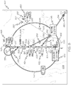
- the display process 200 and/or processing system 106 determines the amount of textual procedure information to be displayed on the navigational map 300 based on the range setting of the navigational map 300. As illustrated in FIG. 5 , at the range setting of 18 nautical miles, the display process 200 and/or processing system 106 may determine to only display the highest priority textual procedure information associated with the symbols 320, 322, 324, 326, 328, 330 based on the range setting and/or the distance between the symbols 320, 322, 324, 326, 328, 330. Turning now to FIG.
- a user may manipulate the user input device 104 to decrease the range setting of the map 300 from 18 nautical miles to 11 nautical miles.
- the display process 200 and/or processing system 106 determines an increased amount of textual procedure information to be displayed and automatically updates the navigational map 300 to include the increased amount of textual procedure information.
- the display process 200 and/or processing system 106 determines lower priority textual procedure information (e.g., distances between other navigational reference points) associated with the symbols 312, 320, 322, 324, 328, 330 should be displayed and automatically updates the displayed textual information 315, 420, 422, 424, 428, 430 to include the lower priority textual procedure information.
- lower priority textual procedure information e.g., distances between other navigational reference points
- the display process 200 and/or processing system 106 determines or otherwise identifies that higher priority textual procedure information associated with the navigational segments 317, 319, 321, 323, 325, 327, 335, procedure turn 331, and missed approach 337 should be displayed and automatically updates the navigational map 300 to include the textual information 817, 819, 821, 823, 825, 827, 831, 835, 837 identified for display.
- the displayed textual information 817, 819, 821, 823, 825, 827, 835, 837 for the navigational segments and missed approach include bearing (or heading) information for those respective segments, while the displayed textual information 831 for the procedure turn includes a minimum altitude criterion (e.g., 9000 feet) in addition to bearing information.
- the display process 200 and/or processing system 106 may maintain the graphic element displayed within the map 300 but include graphical indicia to indicate the graphic element is outside the geographic area of the map 300. For example, as illustrated in FIG.
- the display process 200 and/or processing system 106 may maintain the symbol 310 displayed on the navigational map 300 but include graphical indicia 850 proximate the symbol 310 and overlying the navigational segment 314 to/from that symbol 310 to indicate that the geographic location of the RYANN reference point that corresponds to symbol 310 is outside of the geographic area displayed on the map 300.
- the user may further decrease the range setting of the map 300 from 11 nautical miles to 5 nautical miles, wherein in response, the display process 200 and/or processing system 106 further increases the amount of textual procedure information displayed on the navigational map 300.
- the display process 200 and/or processing system 106 determines additional lower priority textual procedure information (e.g., the minimum altitude for the segments and the distance for the segments) associated with the navigational segments 319, 321, 323, 325 within the displayed area of the navigational map 300 should be displayed and automatically updates the displayed textual information 819, 821, 823, 825 to include the lower priority textual procedure information.
- additional lower priority textual procedure information e.g., the minimum altitude for the segments and the distance for the segments
- the display process 200 and/or processing system 106 determines additional lower priority textual procedure information (e.g., the radar fix designation) associated with the TAKLE navigational reference point 324 should be displayed and automatically updates the displayed textual information 824 to include the additional lower priority textual procedure information.
- additional lower priority textual procedure information e.g., the radar fix designation
- the textual aircraft procedure information is radially positioned with respect to the graphic aircraft procedure information.
- the center of the textual procedure information 1025 associated with the TAKLE reference point symbol 1024 is offset from the symbol 1024 along a radius 1001 that is maintained by the data storage element 118 in association with the textual information 1025.
- the radius 1001 has a fixed length that corresponds to a desired separation distance on the display device 102 between the center of the textual information 1025 and the symbol 1024 (e.g., half an inch between the textual information 1025 and the symbol 1024 when displayed on the display device 102).
- the radius 1001 has a fixed offset angle (or bearing) relative to the symbol 1024 that defines the positioning of the information 1025 when the navigational map 1000 is oriented north-up (i.e., when the aircraft 120 is heading due north or 0°).
- the fixed offset angle is chosen to ensure that the information 1025 does not overlap neighboring procedure information (e.g., navigational segments to/from the TAKLE reference point or adjacent navigational reference points).
- the radius 1001 for the information 1025 associated with the TAKLE symbol 1024 may have an offset angle of 270°.
- the information 1025 is always displayed at a bearing of 270° relative to the symbol 1024 and at a fixed distance on the display device 102 from the symbol 1024 as defined by the radius 1001.
- the background 1004 and the symbolic procedure information are rotated by -15° (or 15° in the counterclockwise direction) offset the change in the heading of the aircraft 120, such that the graphical representation 1002 of the aircraft 120 remains oriented toward the top of the map 1000.
- the displayed textual aircraft procedure information is rotated in a corresponding manner and radially repositioned to prevent the displayed textual aircraft procedure information from overlapping or otherwise obscuring other displayed aircraft procedure information.
- the information 1025 is rotated in a corresponding manner (e.g., by -15° to offset the 15° rotation of the aircraft 120 and remain upright) and is radially repositioned using the radius 1001 associated with the information 1025, such that the center of the information 1025 remains displayed at a bearing of 270° relative to the symbol 1024 and the same distance on the display device 102 from the symbol 1024.
- the rotation of the textual information 1025 by a corresponding amount opposite the change in the aircraft heading results in the orientation of the textual information 1025 remaining right-side up.
- FIG. 12 depicts another embodiment of a navigational map 1200 in accordance with another embodiment of the display process 200.
- the processing system 106 and/or display process 200 periodically and/or continuously obtains current status information for the aircraft 120 (e.g., current flight phase and/or location).
- the processing system 106 and/or display process 200 determines or otherwise identifies that the current flight phase of the aircraft 120 is the missed approach flight phase (e.g., based on the current location of the aircraft 120 indicating the aircraft 120 has passed the intended airport 1206), and in response to determining the aircraft 120 is in the missed approach flight phase, the processing system 106 and/or display process 200 automatically displays the missed approach procedure information 1230 overlying the navigational map 1200.
- the processing system 106 and/or display process 200 displays the missed approach procedure information 1230 as an inset within the navigational map 1200.
- the missed approach procedure information 1230 overlies the background 1204 of the navigational map 1200 at a location that does not accurately reflect the real-world location of the missed approach procedure information 1230 with respect to the underlying terrain 1204.
- the processing system 106 and/or display process 200 may also display a second graphical representation 1260 of the aircraft 120 at the appropriate geographic location within the missed approach procedure inset 1230.
- the positioning of the second graphical representation 1260 of the aircraft 120 with respect to the displayed graphic elements of the missed approach procedure information 1230 accurately reflects the real-world location of the aircraft 120 with respect to the geographic locations corresponding to those displayed graphic elements.
- the second graphical representation 1260 of the aircraft 120 refreshes or otherwise updates as the aircraft 120 travels, such that the graphical representation 1260 is positioned over the graphic elements of the missed approach procedure information 1230 in a manner that accurately reflects the current (e.g., instantaneous or substantially real-time) real-world positioning of the aircraft 120 relative to the navigational reference points and/or navigational segments of the missed approach procedure 1230.
- the other aircraft graphic 1202 reflects the real-world location of the aircraft 120 with respect to the underlying terrain 1204.
- one advantage of the methods and systems described above is that relevant aircraft procedure information is displayed overlying a navigational map in a decluttered manner. For example, as described above, when a user increases the range setting (or zooms out), the amount of displayed aircraft procedure information is automatically decreased to prevent obscuring and/or obfuscating neighboring aircraft procedure information. At the same time, after the amount of displayed aircraft procedure information is decreased, when the flight phase and/or current location of the aircraft indicates that some additional aircraft procedure information that is not currently displayed may be relevant to the current operation of the aircraft, the amount of displayed aircraft procedure information is increased to provide the additional information that is likely to be relevant.
- the amount of displayed aircraft procedure information may be decreased to declutter the navigational map.
- the displayed aircraft procedure information may also be dynamically increased and/or decreased in size based on the current operating status of the aircraft.
- textual procedure information may be radially repositioned with respect to and/or offset from its associated graphic procedure element to ensure the textual procedure information is displayed in a clear and conspicuous manner.
- portions of the aircraft procedure information that are outside the geographic area of the navigational map may be inset within the navigational map or displayed with graphical indicia that designates those portions of the aircraft procedure information are outside of the map area.
- an approach should be understood as referring to a predefined flight path or other guidance intended to facilitate a safe landing for an aircraft at a particular runway, landing strip, airstrip, another suitable landing location, or a set of landing locations.
- a navigational map being associated with a current location and/or heading of the aircraft (e.g., a moving map display)
- the subject matter is not limited to navigational maps associated with the location of the aircraft.
- the user may manipulate a user input device to scroll the navigational map away from the current location of the aircraft to view other portions of a flight plan, or to simulate and/or brief upcoming portions of the flight plan.
- a graphical representation of the aircraft need not be displayed in the navigational map, however, the systems and methods described herein may still be utilized to determine the amount of procedure information to be displayed in the navigational map and dynamically update the displayed procedure information, even though the aircraft is not displayed on the navigational map.
- the current status information e.g., aircraft flight phase and/or aircraft location
- the methods and systems described above may be provided or otherwise by the user to emulate operation of the aircraft.
- embodiments of the subject matter described herein can be stored on, encoded on, or otherwise embodied by any suitable non-transitory computer-readable medium as computer-executable instructions or data stored thereon that, when executed (e.g., by processing system 106), facilitate display of aircraft procedure information overlying a navigational map on a display device (e.g., display device 102) in accordance with the display process 200 described above.
- a display device e.g., display device 102
- Coupled means that one element/node/feature is directly or indirectly joined to (or directly or indirectly communicates with) another element/node/feature, and not necessarily mechanically.
- drawings may depict one exemplary arrangement of elements, additional intervening elements, devices, features, or components may be present in an embodiment of the depicted subject matter.
- certain terminology may also be used in the following description for the purpose of reference only, and thus are not intended to be limiting.
Landscapes
- Engineering & Computer Science (AREA)
- Aviation & Aerospace Engineering (AREA)
- Physics & Mathematics (AREA)
- General Physics & Mathematics (AREA)
- Radar, Positioning & Navigation (AREA)
- Remote Sensing (AREA)
- Traffic Control Systems (AREA)
- Instructional Devices (AREA)
- Navigation (AREA)
Claims (8)
- Procédé de présentation d'informations sur un dispositif d'affichage (102) associé à un aéronef (120), le procédé comprenant :l'affichage, sur le dispositif d'affichage (102), d'une carte de navigation ;l'affichage, sur le dispositif d'affichage (102) en surimpression sur la carte de navigation, d'un élément graphique d'une procédure pour aéronef, l'élément graphique illustrant un aspect d'une action d'aéronef et comportant des informations textuelles qui lui sont associées, les informations textuelles décrivant des paramètres de conduite ou des instructions permettant l'exécution de l'action d'aéronef ;l'obtention d'informations d'état pour l'aéronef (120) ;la détermination d'une quantité des informations textuelles à afficher sur la base en partie au moins des informations d'état ; etl'affichage, sur le dispositif d'affichage (102) en surimpression sur la carte de navigation, de la quantité déterminée des informations textuelles de procédure à proximité de l'élément graphique.
- Procédé selon la revendication 1, comprenant en outre l'augmentation de la quantité des informations textuelles (424) affichées sur le dispositif d'affichage (102) lorsqu'une distance entre une position de l'aéronef (120) et une position associée à l'élément graphique (324) est inférieure à une valeur de seuil.
- Procédé selon la revendication 1, comprenant en outre l'augmentation d'une taille des informations textuelles (424) affichées sur le dispositif d'affichage (102) lorsqu'une distance entre une position de l'aéronef (120) et une position associée à l'élément graphique (324) est inférieure à une valeur de seuil.
- Procédé selon la revendication 1, comprenant en outre la mise à jour de la quantité des informations textuelles affichées sur le dispositif d'affichage (102) en réponse à un changement des informations d'état.
- Procédé selon la revendication 1, comprenant en outre l'indication graphique d'une association entre les informations textuelles et l'élément graphique en réponse à un changement d'un réglage d'affichage pour la carte de navigation, dans lequel la détermination de la quantité des informations textuelles à afficher comprend la détermination de la quantité des informations textuelles à afficher sur la base des informations d'état et du réglage d'affichage.
- Procédé selon la revendication 5, le réglage d'affichage comprenant un réglage d'étendue et l'élément graphique comprenant un segment de navigation (323), les informations textuelles (823) étant initialement affichées suivant le segment de navigation, dans lequel l'indication graphique de l'association comprend :l'affichage des informations textuelles (723) en décalage par rapport au segment de navigation (323) en réponse à l'augmentation du réglage d'étendue ; etl'affichage d'un segment de ligne (740) entre le segment de navigation (323) et les informations textuelles (723).
- Procédé selon la revendication 1, dans lequel la quantité déterminée des informations textuelles et l'élément graphique sont affichés sous forme d'une incrustation (1230) dans la carte de navigation (1200).
- Système (100) comprenant :un dispositif d'affichage (102) à bord d'un aéronef (120), dispositif d'affichage (102) sur lequel est affichée une carte de navigation relative à la conduite de l'aéronef (120) ;un élément de stockage de données (118) configuré pour conserver des informations de procédure portant sur une procédure pour aéronef, les informations de procédure comportant un élément graphique illustrant un aspect d'une action d'aéronef et des informations textuelles associées à l'élément graphique, les informations textuelles décrivant des paramètres de conduite ou des instructions permettant l'exécution de l'action d'aéronef ; etun système de traitement (106) couplé au dispositif d'affichage (102) et à l'élément de stockage de données (118), lequel système de traitement (106) est configuré pour :afficher, sur le dispositif d'affichage, l'élément graphique en surimpression sur la carte de navigation ;obtenir des informations d'état pour l'aéronef ;déterminer une quantité des informations textuelles à afficher sur la base en partie au moins des informations d'état ; etafficher, sur le dispositif d'affichage, la quantité déterminée d'informations textuelles en surimpression sur la carte de navigation à proximité de l'élément graphique.
Applications Claiming Priority (1)
| Application Number | Priority Date | Filing Date | Title |
|---|---|---|---|
| US13/154,130 US9146133B2 (en) | 2011-06-06 | 2011-06-06 | Methods and systems for displaying procedure information on an aircraft display |
Publications (3)
| Publication Number | Publication Date |
|---|---|
| EP2533015A2 EP2533015A2 (fr) | 2012-12-12 |
| EP2533015A3 EP2533015A3 (fr) | 2015-12-23 |
| EP2533015B1 true EP2533015B1 (fr) | 2017-01-18 |
Family
ID=46201398
Family Applications (1)
| Application Number | Title | Priority Date | Filing Date |
|---|---|---|---|
| EP12168590.3A Active EP2533015B1 (fr) | 2011-06-06 | 2012-05-18 | Procédés et systèmes pour afficher des informations de procédure sur un écran d'avion |
Country Status (3)
| Country | Link |
|---|---|
| US (1) | US9146133B2 (fr) |
| EP (1) | EP2533015B1 (fr) |
| CN (1) | CN102815404B (fr) |
Families Citing this family (35)
| Publication number | Priority date | Publication date | Assignee | Title |
|---|---|---|---|---|
| US10041802B1 (en) * | 2011-09-28 | 2018-08-07 | The Boeing Company | Methods and systems for depicting own ship |
| US9132913B1 (en) * | 2013-09-26 | 2015-09-15 | Rockwell Collins, Inc. | Simplified auto-flight system coupled with a touchscreen flight control panel |
| WO2013067526A1 (fr) * | 2011-11-04 | 2013-05-10 | Remote TelePointer, LLC | Procédé et système pour une interface utilisateur pour des dispositifs interactifs utilisant un dispositif mobile |
| FR2991470B1 (fr) * | 2012-06-01 | 2015-02-27 | Thales Sa | Systeme d'autorisation d'arret des taches de pilotage |
| US9262931B2 (en) * | 2012-12-07 | 2016-02-16 | Honeywell International Inc. | System and method for graphically generating an approach/departure course |
| US9020664B2 (en) * | 2013-04-15 | 2015-04-28 | Honeywell International Inc. | Methods and systems for displaying procedure information on an aircraft display |
| FR3006785B1 (fr) * | 2013-06-10 | 2015-07-03 | Snecma | Procedes de creation d'une base de donnees et d'elaboration d'une carte d'etats de fonctionnement de moteurs d'aeronefs, et un procede de surveillance du fonctionnement d'un moteur d'aeronef associe |
| FR3007854B1 (fr) | 2013-06-28 | 2015-07-03 | Thales Sa | Procede et dispositif de calcul d'un plan de vol d'un aeronef en phase d'approche d'une piste d'atterrissage |
| US10380775B2 (en) * | 2013-08-30 | 2019-08-13 | Insitu, Inc. | Map declutter |
| CN103618880A (zh) * | 2013-12-05 | 2014-03-05 | 中国航空无线电电子研究所 | 一种用于模拟飞机显示控制系统界面的图像合成方法 |
| FR3014555B1 (fr) * | 2013-12-11 | 2016-01-15 | Thales Sa | Systeme de representation d'indications cartographiques a echelles multiples |
| US9611051B2 (en) * | 2014-08-26 | 2017-04-04 | The Boeing Company | Aircraft position display system |
| EP3132619B1 (fr) * | 2015-03-31 | 2022-03-23 | SZ DJI Technology Co., Ltd. | Systèmes et procédés d'affichage d'informations d'un dispositif de géorepérage |
| CN107409051B (zh) | 2015-03-31 | 2021-02-26 | 深圳市大疆创新科技有限公司 | 用于生成飞行管制的认证系统和方法 |
| JP6459014B2 (ja) | 2015-03-31 | 2019-01-30 | エスゼット ディージェイアイ テクノロジー カンパニー リミテッドSz Dji Technology Co.,Ltd | ジオフェンシング装置 |
| KR101695697B1 (ko) * | 2015-07-29 | 2017-01-12 | 엘지전자 주식회사 | 이동 단말기 및 이의 제어방법 |
| US10152195B2 (en) * | 2015-12-14 | 2018-12-11 | Honeywell International Inc. | Aircraft display system pertaining to energy management |
| US10473484B1 (en) * | 2016-04-01 | 2019-11-12 | Hilton Goldstein | System and method for mapping aircraft position on a non-linear flight procedure chart |
| US10684756B2 (en) * | 2016-04-27 | 2020-06-16 | Rockwell Collins, Inc. | Avionics picture-in-picture display |
| US9984578B2 (en) * | 2016-05-03 | 2018-05-29 | Rockwell Collins, Inc. | Digital map enabled boundary search pattern |
| US10750313B2 (en) * | 2017-06-05 | 2020-08-18 | Wing Aviation Llc | Map display of unmanned aircraft systems |
| US10565882B1 (en) * | 2017-09-13 | 2020-02-18 | Rockwell Collins, Inc. | Vertical situation display past and projected path depiction |
| CN108255192A (zh) * | 2017-12-08 | 2018-07-06 | 中国航空工业集团公司成都飞机设计研究所 | 一种小型舰载无人机回收航路规划管理方法 |
| US10761674B2 (en) * | 2018-01-18 | 2020-09-01 | Honeywell International Inc. | Systems and methods for providing user-manipulated primary flight display (PFD) data onboard an aircraft |
| CN108733070A (zh) * | 2018-04-11 | 2018-11-02 | 广州亿航智能技术有限公司 | 无人机控制方法及控制系统 |
| FR3083897A1 (fr) * | 2018-07-11 | 2020-01-17 | Dassault Aviation | Systeme de gestion de taches d'un equipage d'aeronef lors d'une mission et procede associe |
| US11347463B2 (en) * | 2018-10-31 | 2022-05-31 | Honeywell International Inc. | Correlative display system with decluttered displays for aircraft |
| CN112185172B (zh) * | 2019-07-01 | 2024-03-26 | 波音公司 | 飞行器飞行信息系统与方法 |
| US12072206B2 (en) * | 2020-07-29 | 2024-08-27 | Honeywell International Inc. | Systems and methods for displaying terminal area procedure charts |
| DE102020123062A1 (de) * | 2020-09-03 | 2022-03-03 | Volocopter Gmbh | Verfahren zur Signalauswahl und Signalauswahlvorrichtung |
| US12148314B2 (en) | 2021-01-07 | 2024-11-19 | Honeywell International Inc. | System and method for dynamically augmenting raster charts displayed on a cockpit display |
| CN113094205B (zh) * | 2021-04-08 | 2024-12-20 | 民航数据通信有限责任公司 | 基于数据链的进离场增强型展示装置 |
| CN113815874B (zh) * | 2021-10-11 | 2022-06-21 | 中国商用飞机有限责任公司 | 用于飞行器的告警信息推送方法和系统 |
| CN115017747B (zh) * | 2022-08-09 | 2022-10-21 | 安胜(天津)飞行模拟系统有限公司 | 一种eVTOL飞机的多倍速仿真重定位运行方法 |
| US12217610B2 (en) * | 2023-02-16 | 2025-02-04 | Rockwell Collins, Inc. | UAM corridor visual indication |
Family Cites Families (77)
| Publication number | Priority date | Publication date | Assignee | Title |
|---|---|---|---|---|
| US3680086A (en) * | 1969-11-26 | 1972-07-25 | North American Rockwell | Ground mapping radar system |
| US4489389A (en) * | 1981-10-02 | 1984-12-18 | Harris Corporation | Real time video perspective digital map display |
| US4660157A (en) * | 1981-10-02 | 1987-04-21 | Harris Corporation | Real time video perspective digital map display method |
| US4862374A (en) * | 1988-05-13 | 1989-08-29 | Ziemann Erich T | Navigational plotting system |
| IT1229222B (it) * | 1989-03-31 | 1991-07-26 | Ausimont Srl | Emulsioni stabili di perfluoropolieteri |
| JPH0352542A (ja) * | 1989-07-18 | 1991-03-06 | Toshiba Corp | 回転機振動診断装置 |
| US6195609B1 (en) * | 1993-09-07 | 2001-02-27 | Harold Robert Pilley | Method and system for the control and management of an airport |
| JPH04284263A (ja) * | 1991-03-14 | 1992-10-08 | Fujitsu Ltd | 磁気インク記録方法とその装置 |
| JPH04288584A (ja) * | 1991-03-18 | 1992-10-13 | Pioneer Electron Corp | 地図表示装置 |
| JP3108122B2 (ja) * | 1991-04-25 | 2000-11-13 | パイオニア株式会社 | 車載ナビゲーション装置 |
| JP2834952B2 (ja) * | 1992-10-22 | 1998-12-14 | アルパイン株式会社 | 経路探索方法 |
| JP2521035B2 (ja) | 1993-12-03 | 1996-07-31 | インターナショナル・ビジネス・マシーンズ・コーポレイション | 表示装置への注釈の配置 |
| US6154219A (en) | 1997-12-01 | 2000-11-28 | Microsoft Corporation | System and method for optimally placing labels on a map |
| JPH11250396A (ja) * | 1998-02-27 | 1999-09-17 | Hitachi Ltd | 車両位置情報表示装置および方法 |
| US6199008B1 (en) | 1998-09-17 | 2001-03-06 | Noegenesis, Inc. | Aviation, terrain and weather display system |
| US6565610B1 (en) | 1999-02-11 | 2003-05-20 | Navigation Technologies Corporation | Method and system for text placement when forming maps |
| US6466235B1 (en) | 1999-09-08 | 2002-10-15 | Rockwell Collins, Inc. | Method and apparatus for interactively and automatically selecting, controlling and displaying parameters for an avionics electronic flight display system |
| US6633801B1 (en) | 1999-10-20 | 2003-10-14 | Stanley H. Durlacher | Method and apparatus for providing information to pilots |
| JP2001124579A (ja) * | 1999-10-27 | 2001-05-11 | Nippon Seiki Co Ltd | ナビゲーション装置 |
| WO2001071485A1 (fr) | 2000-03-17 | 2001-09-27 | Vicinity Corp. | Systeme et procede d'extraction et visualisation d'une carte d'itineraires |
| US7471995B1 (en) | 2000-05-26 | 2008-12-30 | Aerotech Research (Usa), Inc. | Transmission, receipt, combination, sorting, and presentation of vehicle specific environmental conditions and hazards information |
| US20030009694A1 (en) * | 2001-02-25 | 2003-01-09 | Storymail, Inc. | Hardware architecture, operating system and network transport neutral system, method and computer program product for secure communications and messaging |
| US6633810B1 (en) | 2000-09-19 | 2003-10-14 | Honeywell International Inc. | Graphical system and method for defining pilot tasks, patterns and constraints |
| US6522958B1 (en) | 2000-10-06 | 2003-02-18 | Honeywell International Inc. | Logic method and apparatus for textually displaying an original flight plan and a modified flight plan simultaneously |
| US6493630B2 (en) | 2001-02-16 | 2002-12-10 | Wizeguides.Com Inc. | Bundled map guide |
| US6591168B2 (en) * | 2001-08-31 | 2003-07-08 | Intellisist, Inc. | System and method for adaptable mobile user interface |
| AU2003210789A1 (en) * | 2002-02-01 | 2003-09-02 | John Fairweather | A system and method for managing dataflows |
| EP2273237B1 (fr) | 2002-02-19 | 2012-07-18 | The Boeing Company | Système de navigation pour voie de circulation d'aéroport |
| WO2003093768A1 (fr) | 2002-04-30 | 2003-11-13 | Telmap Ltd. | Systeme de navigation utilisant des cartes de couloirs |
| CN1284098C (zh) | 2002-05-21 | 2006-11-08 | 国际商业机器公司 | 图中点标注位置确定装置、终端设备、系统及其方法 |
| EP1516428B1 (fr) | 2002-06-21 | 2008-03-12 | TELECOM ITALIA S.p.A. | Emetteur d'ondes millimetriques mettant en application un heterodynage optique |
| US6868320B1 (en) * | 2002-12-23 | 2005-03-15 | Garmin Ltd. | Methods, devices, and systems for automatic flight logs |
| US7805149B2 (en) | 2004-01-16 | 2010-09-28 | Adidas Ag | Location-aware fitness training device, methods, and program products that support real-time interactive communication and automated route generation |
| JP4145805B2 (ja) | 2003-03-17 | 2008-09-03 | セイコーエプソン株式会社 | テンプレート生成システム、レイアウトシステム、テンプレート生成プログラム、レイアウトプログラムおよびテンプレート生成方法並びにレイアウト方法 |
| FR2853064B1 (fr) * | 2003-03-28 | 2005-06-24 | Systeme embarque de gestion du vol pour aeronef | |
| FR2854948B1 (fr) | 2003-05-16 | 2005-07-29 | Thales Sa | Systeme de gestion de vol |
| CN103398719B (zh) | 2004-03-23 | 2017-04-12 | 咕果公司 | 数字地图描绘系统 |
| US7222017B2 (en) | 2004-06-17 | 2007-05-22 | The Boeing Company | Method and system for entering and displaying ground taxi instructions |
| US7769501B2 (en) | 2004-06-23 | 2010-08-03 | The Boeing Company | User-configurable electronic flight bag |
| US7414637B2 (en) | 2004-09-10 | 2008-08-19 | Telmap Ltd. | Placement of map labels |
| US7917590B2 (en) | 2006-03-13 | 2011-03-29 | Nokia Corporation | Deleting mechanism in SIP multimedia services |
| WO2007114343A1 (fr) * | 2006-03-31 | 2007-10-11 | Pioneer Corporation | Dispositif, procédé et programme de traitement graphique |
| US7693652B2 (en) | 2006-04-05 | 2010-04-06 | Microsoft Corporation | Waypoint adjustment and advertisement for flexible routing |
| US20070288164A1 (en) | 2006-06-08 | 2007-12-13 | Microsoft Corporation | Interactive map application |
| US7693621B1 (en) | 2006-06-27 | 2010-04-06 | Toyota Motor Sales, U.S.A., Inc. | Apparatus and methods for displaying arrival, approach, and departure information on a display device in an aircraft |
| FR2904461B1 (fr) | 2006-07-31 | 2008-10-17 | Airbus France Sas | Procede et dispositif d'affichage d'un plan de vol d'un aeronef |
| US8195383B2 (en) * | 2006-11-29 | 2012-06-05 | The Boeing Company | System and method for electronic moving map and aeronautical context display |
| US8027756B2 (en) * | 2006-12-07 | 2011-09-27 | The Boeing Company | Integrated approach navigation system, method, and computer program product |
| US20080147320A1 (en) * | 2006-12-19 | 2008-06-19 | Garmin International, Inc. | Aircraft airspace display |
| US8706329B2 (en) | 2007-02-15 | 2014-04-22 | The Boeing Company | Facilitating navigation of vessels in specific water environments |
| US20100262318A1 (en) | 2007-05-16 | 2010-10-14 | J. Ariens & Associates, Inc. | Electronic flight bag user interface system |
| FR2920242B1 (fr) | 2007-08-21 | 2009-10-30 | Airbus France Sas | Procede et dispositif d'annotation de fonds cartographiques electroniques |
| US7917289B2 (en) * | 2007-10-30 | 2011-03-29 | Honeywell International Inc. | Perspective view primary flight display system and method with range lines |
| US8319667B2 (en) | 2008-03-11 | 2012-11-27 | Honeywell International Inc. | Missed approach procedure display system and method |
| US8380366B1 (en) * | 2008-03-12 | 2013-02-19 | Garmin International, Inc. | Apparatus for touch screen avionic device |
| US8515674B2 (en) | 2008-05-22 | 2013-08-20 | Mapquest, Inc. | Systems and methods for collecting and using user-contributed map data |
| US8401771B2 (en) | 2008-07-22 | 2013-03-19 | Microsoft Corporation | Discovering points of interest from users map annotations |
| US7852236B2 (en) * | 2008-07-31 | 2010-12-14 | Honeywell International Inc. | Aircraft synthetic vision system for approach and landing |
| JP4500369B2 (ja) * | 2008-09-19 | 2010-07-14 | パナソニック株式会社 | 注意散漫検出装置、注意散漫検出方法およびコンピュータプログラム |
| KR101677756B1 (ko) | 2008-11-03 | 2016-11-18 | 삼성전자주식회사 | 지피에스 수신 주기 및 맵 컨텐츠 자동 최적화 설정 방법 및 장치 |
| US20100131126A1 (en) * | 2008-11-21 | 2010-05-27 | Honeywell International Inc. | System and display element for displaying waypoint markers with integrated altitude constraint information |
| US7986249B2 (en) | 2008-11-24 | 2011-07-26 | Honeywell International Inc. | System and method for displaying graphical departure procedures |
| US20100131481A1 (en) | 2008-11-26 | 2010-05-27 | Honeywell International Inc. | Methods for locating an item when a search mode is not selected |
| US20100148990A1 (en) | 2008-12-17 | 2010-06-17 | Honeywell International Inc. | System and method for selectively displaying terminal procedure data |
| US8370005B2 (en) | 2008-12-19 | 2013-02-05 | Honeywell International Inc. | Methods for displaying aircraft procedure information |
| US8175761B2 (en) * | 2009-02-17 | 2012-05-08 | Honeywell International Inc. | System and method for rendering a synthetic perspective display of a designated object or location |
| US9508270B2 (en) | 2009-02-27 | 2016-11-29 | The Boeing Company | Zoomed viewing of terminal charts |
| US8209122B2 (en) * | 2009-03-27 | 2012-06-26 | Honeywell International Inc. | System and method for rendering visible features of a target location on a synthetic flight display |
| US9293051B2 (en) | 2009-04-21 | 2016-03-22 | Honeywell International Inc. | Methods and systems for displaying a vertical profile for an aircraft procedure with nonuniform scaling |
| US9046369B2 (en) * | 2009-04-29 | 2015-06-02 | Honeywell International Inc. | Methods and systems for updating a map in response to selection of content for display on the map |
| US9851219B2 (en) | 2009-07-09 | 2017-12-26 | Honeywell International Inc. | Methods and systems for route-based scrolling of a navigational map |
| US20110118908A1 (en) | 2009-11-18 | 2011-05-19 | The Boeing Company | Methods and systems for management of airplane speed profile |
| US20110264437A1 (en) | 2010-04-26 | 2011-10-27 | Honeywell International Inc. | System and method for translating an english language message into another language |
| US8532844B2 (en) | 2010-06-22 | 2013-09-10 | Honeywell International Inc. | Methods and systems for displaying annotations on an aircraft display |
| US8838294B2 (en) | 2011-06-06 | 2014-09-16 | Honeywell International Inc. | Methods and systems for briefing aircraft procedures |
| US9495883B2 (en) | 2011-08-02 | 2016-11-15 | Honeywell International Inc. | System and method for displaying a procedure to an aircrew member |
| US9262931B2 (en) * | 2012-12-07 | 2016-02-16 | Honeywell International Inc. | System and method for graphically generating an approach/departure course |
-
2011
- 2011-06-06 US US13/154,130 patent/US9146133B2/en active Active
-
2012
- 2012-05-18 EP EP12168590.3A patent/EP2533015B1/fr active Active
- 2012-06-05 CN CN201210182085.0A patent/CN102815404B/zh not_active Expired - Fee Related
Non-Patent Citations (1)
| Title |
|---|
| None * |
Also Published As
| Publication number | Publication date |
|---|---|
| EP2533015A2 (fr) | 2012-12-12 |
| EP2533015A3 (fr) | 2015-12-23 |
| US20120310524A1 (en) | 2012-12-06 |
| US9146133B2 (en) | 2015-09-29 |
| CN102815404A (zh) | 2012-12-12 |
| CN102815404B (zh) | 2016-05-25 |
Similar Documents
| Publication | Publication Date | Title |
|---|---|---|
| EP2533015B1 (fr) | Procédés et systèmes pour afficher des informations de procédure sur un écran d'avion | |
| EP2400273B1 (fr) | Procédés et systèmes pour afficher des annotations sur un écran d'avion | |
| EP2679959B1 (fr) | Système d'affichage avionique assurant une meilleure gestion de plan de vol | |
| EP1896797B1 (fr) | Affichage de vol primaire a vue en perspective avec lignes de traçage de terrain | |
| US8280618B2 (en) | Methods and systems for inputting taxi instructions | |
| EP1852683B1 (fr) | Système pour afficher de manière sélective les données des procédures d'une aérogare | |
| EP2224216B1 (fr) | Système et procédé pour générer un affichage de vol primaire doté d'un élément conforme de guidage d'évitement de terrain | |
| US12033250B2 (en) | Capability envelope display methods and systems | |
| EP2922046A1 (fr) | Système et procédé permettant d'obtenir une meilleure gestion de plan de vol | |
| EP2779140B1 (fr) | Système et procédé d'alerte d'un équipage à des altitudes limites | |
| US8519997B2 (en) | Apparatus and method for display and functionality of a vehicle display system cursor control device | |
| EP3023741B1 (fr) | Système et procédé d'affichage exocentrique de navigation intégrée | |
| EP3657131B1 (fr) | Système et procédé de présentation de liste de point de cheminement | |
| EP2940674A1 (fr) | Système et procédé pour afficher des notes sensibles au contexte | |
| EP1764759A1 (fr) | Système et procédé d'affichage des espaces aérien protégé ou interdit dans un avion | |
| US12197715B2 (en) | Methods and systems for automated contextual navigation of GUI displays | |
| EP4455854B1 (fr) | Procédés et systèmes de navigation contextuelle automatisée d'affichages gui |
Legal Events
| Date | Code | Title | Description |
|---|---|---|---|
| PUAI | Public reference made under article 153(3) epc to a published international application that has entered the european phase |
Free format text: ORIGINAL CODE: 0009012 |
|
| 17P | Request for examination filed |
Effective date: 20120518 |
|
| AK | Designated contracting states |
Kind code of ref document: A2 Designated state(s): AL AT BE BG CH CY CZ DE DK EE ES FI FR GB GR HR HU IE IS IT LI LT LU LV MC MK MT NL NO PL PT RO RS SE SI SK SM TR |
|
| AX | Request for extension of the european patent |
Extension state: BA ME |
|
| PUAL | Search report despatched |
Free format text: ORIGINAL CODE: 0009013 |
|
| RAP1 | Party data changed (applicant data changed or rights of an application transferred) |
Owner name: HONEYWELL INTERNATIONAL INC. |
|
| AK | Designated contracting states |
Kind code of ref document: A3 Designated state(s): AL AT BE BG CH CY CZ DE DK EE ES FI FR GB GR HR HU IE IS IT LI LT LU LV MC MK MT NL NO PL PT RO RS SE SI SK SM TR |
|
| AX | Request for extension of the european patent |
Extension state: BA ME |
|
| RIC1 | Information provided on ipc code assigned before grant |
Ipc: G08G 5/02 20060101ALI20151116BHEP Ipc: G08G 5/00 20060101ALI20151116BHEP Ipc: G01C 23/00 20060101AFI20151116BHEP |
|
| GRAP | Despatch of communication of intention to grant a patent |
Free format text: ORIGINAL CODE: EPIDOSNIGR1 |
|
| RIC1 | Information provided on ipc code assigned before grant |
Ipc: G08G 5/02 20060101ALI20160801BHEP Ipc: G08G 5/00 20060101ALI20160801BHEP Ipc: G01C 23/00 20060101AFI20160801BHEP |
|
| INTG | Intention to grant announced |
Effective date: 20160908 |
|
| GRAS | Grant fee paid |
Free format text: ORIGINAL CODE: EPIDOSNIGR3 |
|
| GRAA | (expected) grant |
Free format text: ORIGINAL CODE: 0009210 |
|
| AK | Designated contracting states |
Kind code of ref document: B1 Designated state(s): AL AT BE BG CH CY CZ DE DK EE ES FI FR GB GR HR HU IE IS IT LI LT LU LV MC MK MT NL NO PL PT RO RS SE SI SK SM TR |
|
| REG | Reference to a national code |
Ref country code: GB Ref legal event code: FG4D |
|
| REG | Reference to a national code |
Ref country code: CH Ref legal event code: EP |
|
| REG | Reference to a national code |
Ref country code: AT Ref legal event code: REF Ref document number: 863164 Country of ref document: AT Kind code of ref document: T Effective date: 20170215 |
|
| REG | Reference to a national code |
Ref country code: IE Ref legal event code: FG4D |
|
| REG | Reference to a national code |
Ref country code: DE Ref legal event code: R096 Ref document number: 602012027913 Country of ref document: DE |
|
| REG | Reference to a national code |
Ref country code: FR Ref legal event code: PLFP Year of fee payment: 6 |
|
| REG | Reference to a national code |
Ref country code: NL Ref legal event code: MP Effective date: 20170118 |
|
| REG | Reference to a national code |
Ref country code: LT Ref legal event code: MG4D |
|
| REG | Reference to a national code |
Ref country code: AT Ref legal event code: MK05 Ref document number: 863164 Country of ref document: AT Kind code of ref document: T Effective date: 20170118 |
|
| PG25 | Lapsed in a contracting state [announced via postgrant information from national office to epo] |
Ref country code: NL Free format text: LAPSE BECAUSE OF FAILURE TO SUBMIT A TRANSLATION OF THE DESCRIPTION OR TO PAY THE FEE WITHIN THE PRESCRIBED TIME-LIMIT Effective date: 20170118 |
|
| PG25 | Lapsed in a contracting state [announced via postgrant information from national office to epo] |
Ref country code: GR Free format text: LAPSE BECAUSE OF FAILURE TO SUBMIT A TRANSLATION OF THE DESCRIPTION OR TO PAY THE FEE WITHIN THE PRESCRIBED TIME-LIMIT Effective date: 20170419 Ref country code: HR Free format text: LAPSE BECAUSE OF FAILURE TO SUBMIT A TRANSLATION OF THE DESCRIPTION OR TO PAY THE FEE WITHIN THE PRESCRIBED TIME-LIMIT Effective date: 20170118 Ref country code: FI Free format text: LAPSE BECAUSE OF FAILURE TO SUBMIT A TRANSLATION OF THE DESCRIPTION OR TO PAY THE FEE WITHIN THE PRESCRIBED TIME-LIMIT Effective date: 20170118 Ref country code: NO Free format text: LAPSE BECAUSE OF FAILURE TO SUBMIT A TRANSLATION OF THE DESCRIPTION OR TO PAY THE FEE WITHIN THE PRESCRIBED TIME-LIMIT Effective date: 20170418 Ref country code: LT Free format text: LAPSE BECAUSE OF FAILURE TO SUBMIT A TRANSLATION OF THE DESCRIPTION OR TO PAY THE FEE WITHIN THE PRESCRIBED TIME-LIMIT Effective date: 20170118 Ref country code: IS Free format text: LAPSE BECAUSE OF FAILURE TO SUBMIT A TRANSLATION OF THE DESCRIPTION OR TO PAY THE FEE WITHIN THE PRESCRIBED TIME-LIMIT Effective date: 20170518 |
|
| PG25 | Lapsed in a contracting state [announced via postgrant information from national office to epo] |
Ref country code: ES Free format text: LAPSE BECAUSE OF FAILURE TO SUBMIT A TRANSLATION OF THE DESCRIPTION OR TO PAY THE FEE WITHIN THE PRESCRIBED TIME-LIMIT Effective date: 20170118 Ref country code: SE Free format text: LAPSE BECAUSE OF FAILURE TO SUBMIT A TRANSLATION OF THE DESCRIPTION OR TO PAY THE FEE WITHIN THE PRESCRIBED TIME-LIMIT Effective date: 20170118 Ref country code: BG Free format text: LAPSE BECAUSE OF FAILURE TO SUBMIT A TRANSLATION OF THE DESCRIPTION OR TO PAY THE FEE WITHIN THE PRESCRIBED TIME-LIMIT Effective date: 20170418 Ref country code: LU Free format text: LAPSE BECAUSE OF NON-PAYMENT OF DUE FEES Effective date: 20170531 Ref country code: PT Free format text: LAPSE BECAUSE OF FAILURE TO SUBMIT A TRANSLATION OF THE DESCRIPTION OR TO PAY THE FEE WITHIN THE PRESCRIBED TIME-LIMIT Effective date: 20170518 Ref country code: LV Free format text: LAPSE BECAUSE OF FAILURE TO SUBMIT A TRANSLATION OF THE DESCRIPTION OR TO PAY THE FEE WITHIN THE PRESCRIBED TIME-LIMIT Effective date: 20170118 Ref country code: RS Free format text: LAPSE BECAUSE OF FAILURE TO SUBMIT A TRANSLATION OF THE DESCRIPTION OR TO PAY THE FEE WITHIN THE PRESCRIBED TIME-LIMIT Effective date: 20170118 Ref country code: PL Free format text: LAPSE BECAUSE OF FAILURE TO SUBMIT A TRANSLATION OF THE DESCRIPTION OR TO PAY THE FEE WITHIN THE PRESCRIBED TIME-LIMIT Effective date: 20170118 Ref country code: AT Free format text: LAPSE BECAUSE OF FAILURE TO SUBMIT A TRANSLATION OF THE DESCRIPTION OR TO PAY THE FEE WITHIN THE PRESCRIBED TIME-LIMIT Effective date: 20170118 |
|
| REG | Reference to a national code |
Ref country code: DE Ref legal event code: R097 Ref document number: 602012027913 Country of ref document: DE |
|
| PG25 | Lapsed in a contracting state [announced via postgrant information from national office to epo] |
Ref country code: CZ Free format text: LAPSE BECAUSE OF FAILURE TO SUBMIT A TRANSLATION OF THE DESCRIPTION OR TO PAY THE FEE WITHIN THE PRESCRIBED TIME-LIMIT Effective date: 20170118 Ref country code: EE Free format text: LAPSE BECAUSE OF FAILURE TO SUBMIT A TRANSLATION OF THE DESCRIPTION OR TO PAY THE FEE WITHIN THE PRESCRIBED TIME-LIMIT Effective date: 20170118 Ref country code: SK Free format text: LAPSE BECAUSE OF FAILURE TO SUBMIT A TRANSLATION OF THE DESCRIPTION OR TO PAY THE FEE WITHIN THE PRESCRIBED TIME-LIMIT Effective date: 20170118 Ref country code: IT Free format text: LAPSE BECAUSE OF FAILURE TO SUBMIT A TRANSLATION OF THE DESCRIPTION OR TO PAY THE FEE WITHIN THE PRESCRIBED TIME-LIMIT Effective date: 20170118 Ref country code: RO Free format text: LAPSE BECAUSE OF FAILURE TO SUBMIT A TRANSLATION OF THE DESCRIPTION OR TO PAY THE FEE WITHIN THE PRESCRIBED TIME-LIMIT Effective date: 20170118 |
|
| PLBE | No opposition filed within time limit |
Free format text: ORIGINAL CODE: 0009261 |
|
| STAA | Information on the status of an ep patent application or granted ep patent |
Free format text: STATUS: NO OPPOSITION FILED WITHIN TIME LIMIT |
|
| PG25 | Lapsed in a contracting state [announced via postgrant information from national office to epo] |
Ref country code: SM Free format text: LAPSE BECAUSE OF FAILURE TO SUBMIT A TRANSLATION OF THE DESCRIPTION OR TO PAY THE FEE WITHIN THE PRESCRIBED TIME-LIMIT Effective date: 20170118 Ref country code: DK Free format text: LAPSE BECAUSE OF FAILURE TO SUBMIT A TRANSLATION OF THE DESCRIPTION OR TO PAY THE FEE WITHIN THE PRESCRIBED TIME-LIMIT Effective date: 20170118 |
|
| 26N | No opposition filed |
Effective date: 20171019 |
|
| REG | Reference to a national code |
Ref country code: CH Ref legal event code: PL |
|
| PG25 | Lapsed in a contracting state [announced via postgrant information from national office to epo] |
Ref country code: MC Free format text: LAPSE BECAUSE OF FAILURE TO SUBMIT A TRANSLATION OF THE DESCRIPTION OR TO PAY THE FEE WITHIN THE PRESCRIBED TIME-LIMIT Effective date: 20170118 |
|
| REG | Reference to a national code |
Ref country code: IE Ref legal event code: MM4A |
|
| PG25 | Lapsed in a contracting state [announced via postgrant information from national office to epo] |
Ref country code: SI Free format text: LAPSE BECAUSE OF FAILURE TO SUBMIT A TRANSLATION OF THE DESCRIPTION OR TO PAY THE FEE WITHIN THE PRESCRIBED TIME-LIMIT Effective date: 20170118 Ref country code: LI Free format text: LAPSE BECAUSE OF NON-PAYMENT OF DUE FEES Effective date: 20170531 Ref country code: CH Free format text: LAPSE BECAUSE OF NON-PAYMENT OF DUE FEES Effective date: 20170531 |
|
| PG25 | Lapsed in a contracting state [announced via postgrant information from national office to epo] |
Ref country code: LU Free format text: LAPSE BECAUSE OF NON-PAYMENT OF DUE FEES Effective date: 20170518 |
|
| PG25 | Lapsed in a contracting state [announced via postgrant information from national office to epo] |
Ref country code: IE Free format text: LAPSE BECAUSE OF NON-PAYMENT OF DUE FEES Effective date: 20170518 |
|
| REG | Reference to a national code |
Ref country code: FR Ref legal event code: PLFP Year of fee payment: 7 |
|
| PG25 | Lapsed in a contracting state [announced via postgrant information from national office to epo] |
Ref country code: MT Free format text: LAPSE BECAUSE OF NON-PAYMENT OF DUE FEES Effective date: 20170518 |
|
| PG25 | Lapsed in a contracting state [announced via postgrant information from national office to epo] |
Ref country code: HU Free format text: LAPSE BECAUSE OF FAILURE TO SUBMIT A TRANSLATION OF THE DESCRIPTION OR TO PAY THE FEE WITHIN THE PRESCRIBED TIME-LIMIT; INVALID AB INITIO Effective date: 20120518 |
|
| PGFP | Annual fee paid to national office [announced via postgrant information from national office to epo] |
Ref country code: DE Payment date: 20190531 Year of fee payment: 8 |
|
| PGFP | Annual fee paid to national office [announced via postgrant information from national office to epo] |
Ref country code: BE Payment date: 20190527 Year of fee payment: 8 |
|
| PG25 | Lapsed in a contracting state [announced via postgrant information from national office to epo] |
Ref country code: CY Free format text: LAPSE BECAUSE OF NON-PAYMENT OF DUE FEES Effective date: 20170118 |
|
| PGFP | Annual fee paid to national office [announced via postgrant information from national office to epo] |
Ref country code: GB Payment date: 20190529 Year of fee payment: 8 |
|
| PG25 | Lapsed in a contracting state [announced via postgrant information from national office to epo] |
Ref country code: MK Free format text: LAPSE BECAUSE OF FAILURE TO SUBMIT A TRANSLATION OF THE DESCRIPTION OR TO PAY THE FEE WITHIN THE PRESCRIBED TIME-LIMIT Effective date: 20170118 |
|
| PG25 | Lapsed in a contracting state [announced via postgrant information from national office to epo] |
Ref country code: TR Free format text: LAPSE BECAUSE OF FAILURE TO SUBMIT A TRANSLATION OF THE DESCRIPTION OR TO PAY THE FEE WITHIN THE PRESCRIBED TIME-LIMIT Effective date: 20170118 |
|
| PG25 | Lapsed in a contracting state [announced via postgrant information from national office to epo] |
Ref country code: AL Free format text: LAPSE BECAUSE OF FAILURE TO SUBMIT A TRANSLATION OF THE DESCRIPTION OR TO PAY THE FEE WITHIN THE PRESCRIBED TIME-LIMIT Effective date: 20170118 |
|
| REG | Reference to a national code |
Ref country code: DE Ref legal event code: R119 Ref document number: 602012027913 Country of ref document: DE |
|
| REG | Reference to a national code |
Ref country code: BE Ref legal event code: MM Effective date: 20200531 |
|
| GBPC | Gb: european patent ceased through non-payment of renewal fee |
Effective date: 20200518 |
|
| PG25 | Lapsed in a contracting state [announced via postgrant information from national office to epo] |
Ref country code: GB Free format text: LAPSE BECAUSE OF NON-PAYMENT OF DUE FEES Effective date: 20200518 |
|
| PG25 | Lapsed in a contracting state [announced via postgrant information from national office to epo] |
Ref country code: BE Free format text: LAPSE BECAUSE OF NON-PAYMENT OF DUE FEES Effective date: 20200531 Ref country code: DE Free format text: LAPSE BECAUSE OF NON-PAYMENT OF DUE FEES Effective date: 20201201 |
|
| P01 | Opt-out of the competence of the unified patent court (upc) registered |
Effective date: 20230525 |
|
| PGFP | Annual fee paid to national office [announced via postgrant information from national office to epo] |
Ref country code: FR Payment date: 20250526 Year of fee payment: 14 |