EP2543964A1 - Surface de route d'un repère tridimensionnel - Google Patents
Surface de route d'un repère tridimensionnel Download PDFInfo
- Publication number
- EP2543964A1 EP2543964A1 EP11175431A EP11175431A EP2543964A1 EP 2543964 A1 EP2543964 A1 EP 2543964A1 EP 11175431 A EP11175431 A EP 11175431A EP 11175431 A EP11175431 A EP 11175431A EP 2543964 A1 EP2543964 A1 EP 2543964A1
- Authority
- EP
- European Patent Office
- Prior art keywords
- dimensional
- landmark
- dimensional landmark
- traffic area
- road traffic
- Prior art date
- Legal status (The legal status is an assumption and is not a legal conclusion. Google has not performed a legal analysis and makes no representation as to the accuracy of the status listed.)
- Granted
Links
Images



Classifications
-
- G—PHYSICS
- G01—MEASURING; TESTING
- G01C—MEASURING DISTANCES, LEVELS OR BEARINGS; SURVEYING; NAVIGATION; GYROSCOPIC INSTRUMENTS; PHOTOGRAMMETRY OR VIDEOGRAMMETRY
- G01C21/00—Navigation; Navigational instruments not provided for in groups G01C1/00 - G01C19/00
- G01C21/26—Navigation; Navigational instruments not provided for in groups G01C1/00 - G01C19/00 specially adapted for navigation in a road network
- G01C21/34—Route searching; Route guidance
- G01C21/36—Input/output arrangements for on-board computers
-
- G—PHYSICS
- G01—MEASURING; TESTING
- G01C—MEASURING DISTANCES, LEVELS OR BEARINGS; SURVEYING; NAVIGATION; GYROSCOPIC INSTRUMENTS; PHOTOGRAMMETRY OR VIDEOGRAMMETRY
- G01C21/00—Navigation; Navigational instruments not provided for in groups G01C1/00 - G01C19/00
- G01C21/26—Navigation; Navigational instruments not provided for in groups G01C1/00 - G01C19/00 specially adapted for navigation in a road network
- G01C21/34—Route searching; Route guidance
- G01C21/36—Input/output arrangements for on-board computers
- G01C21/3626—Details of the output of route guidance instructions
- G01C21/3635—Guidance using 3D or perspective road maps
- G01C21/3638—Guidance using 3D or perspective road maps including 3D objects and buildings
-
- G—PHYSICS
- G01—MEASURING; TESTING
- G01C—MEASURING DISTANCES, LEVELS OR BEARINGS; SURVEYING; NAVIGATION; GYROSCOPIC INSTRUMENTS; PHOTOGRAMMETRY OR VIDEOGRAMMETRY
- G01C21/00—Navigation; Navigational instruments not provided for in groups G01C1/00 - G01C19/00
- G01C21/26—Navigation; Navigational instruments not provided for in groups G01C1/00 - G01C19/00 specially adapted for navigation in a road network
- G01C21/34—Route searching; Route guidance
- G01C21/3453—Special cost functions, i.e. other than distance or default speed limit of road segments
- G01C21/3476—Special cost functions, i.e. other than distance or default speed limit of road segments using point of interest [POI] information, e.g. a route passing visible POIs
-
- G—PHYSICS
- G01—MEASURING; TESTING
- G01C—MEASURING DISTANCES, LEVELS OR BEARINGS; SURVEYING; NAVIGATION; GYROSCOPIC INSTRUMENTS; PHOTOGRAMMETRY OR VIDEOGRAMMETRY
- G01C21/00—Navigation; Navigational instruments not provided for in groups G01C1/00 - G01C19/00
- G01C21/38—Electronic maps specially adapted for navigation; Updating thereof
- G01C21/3863—Structures of map data
- G01C21/3867—Geometry of map features, e.g. shape points, polygons or for simplified maps
-
- G—PHYSICS
- G06—COMPUTING OR CALCULATING; COUNTING
- G06T—IMAGE DATA PROCESSING OR GENERATION, IN GENERAL
- G06T15/00—Three-dimensional [3D] image rendering
- G06T15/005—General purpose rendering architectures
Definitions
- the present invention relates to a method for processing a 3-dimensional landmark representing a 3-dimensional real world object, to a processing unit configured to process the 3-dimensional landmark, to a method for displaying route guidance recommendations to a user of a navigation system and to the navigation system providing the driving recommendations.
- navigation systems which provide driving recommendations to a user-defined destination.
- a navigation system After having calculated the route to the desired destination, displays a two-dimensional bird's eye view map, the map indicating the road network in which the recommended route is somehow highlighted to the driver, e.g. by displaying a line with a certain colour in the road network.
- the navigation system displays a 3-dimensional route guidance information which gives the driver a better impression of the vehicle surroundings.
- the database containing the map data can additionally contain 3-dimensional landmarks providing a 3-dimensional representation of a 3-dimensional real world object.
- An example for such a landmark is a 3-dimensional representation in the map data of famous monuments, e.g.
- the Golden Gate Bridge or the Tower Bridge Another example could be a famous city gate.
- These 3-dimensional landmarks are sometimes part of the road surface used by a vehicle for driving on or by a pedestrian for walking on.
- the data set providing the 3-dimensional landmark does not contain an information which part of the landmark is used for driving.
- a method for processing a 3-dimensional landmark providing a 3-dimensional representation of a real world object located at a predefined geographic location.
- a data set is provided containing the 3-dimensional landmark and in the data set a largest continuous horizontal surface of the 3-dimensional landmark is determined and stored as a road traffic area of a road network used by a user when moving on said object.
- the 3-dimensional landmark may be a famous bridge, however, it is also possible that the landmark is any other 3-dimensional object which is part of the road network, e.g. a city gate through which roads pass.
- the user may be a pedestrian or may be a vehicle driver driving in a vehicle.
- the data set containing the 3-dimensional landmark can contain an array of vertices defining different faces of the real world object, the data set furthermore containing normal vectors for the different faces.
- the largest continuous horizontal surface can then be determined by comparing the normal vectors of the different faces and by identifying, among the normal vectors of the 3-dimensional landmark, first normal vectors that have a vertical orientation and that represent neighbouring horizontal faces. When the horizontal faces belonging to the identified first normal vectors are identified, the largest horizontal surface of the 3-dimensional landmark is found.
- the orientation of the 3-dimensional landmark for displaying the 3-dimensional landmark is known so that the directions up, down, left and right for the landmark are known.
- the normal vectors are identified that have a vertical upward orientation. With the upward orientation it can be made sure that the determined largest continuous horizontal surface is facing upwards and not downwards towards the earth. Furthermore, it is possible that the data set of the landmark is processed from the top end to the bottom end to identify the largest continuous horizontal surface.
- the invention furthermore provides a processing system configured to process the 3-dimensional landmark as mentioned above, the processing system comprising a database containing at least a data set containing the 3-dimensional landmark and containing map data representing a road network used by a vehicle for driving or by the pedestrian for walking. Furthermore, an image data processing unit is provided processing the 3-dimensional landmark and configured to determine the largest continuous horizontal surface as mentioned above and configured to store in the database the determined largest horizontal surface as part of the road network.
- a method for displaying route guidance recommendations to a vehicle driver is provided.
- a driving route is determined, along which the user is moving.
- a road traffic area of the 3-dimensional landmark that is located along the route is determined and the road traffic area of the 3-dimensional landmark is marked with a predefined texture.
- a 3-dimensional route guidance information is displayed including a 3-dimensional representation of at least a section of the route and including the 3-dimensional landmark with the marked road traffic area in the object.
- This displaying method uses the processed landmark that was processed as mentioned above to identify the road traffic area. With this method it becomes possible to include the landmark in the 3-dimensional representation of the route guidance or walking recommendation as part of the recommended route.
- the route guidance information may include a displayed line which the vehicle driver or pedestrian should follow, the line including the marked road traffic area of the 3-dimensional landmark.
- a navigation system providing route guidance recommendations, the navigation system containing a navigation unit configured to determine a route, the navigation system further containing a database containing at least one data set containing the 3-dimensional landmark and containing map data representing a road network used by a vehicle for driving or by the pedestrian for walking.
- the navigation system furthermore contains an image viewer configured to display 3-dimensional route guidance information including a 3-dimensional representation of at least a section of the recommended route.
- the image viewer is configured to determine a road traffic area of the 3-dimensional landmark, is configured to mark the road traffic area with a predefined texture and is configured to display the 3-dimensional route guidance information including the 3-dimensional landmark with the marked road traffic area.
- the image viewer can determine the road traffic area simply by retrieving the information of the road traffic area from the information stored in connection with the data set, that is representing the 3-dimensional landmark.
- a processing system 10 is shown with which it is possible to identify a road traffic area of a data set of a landmark providing a 3-dimensional representation of a real world object.
- This system contains a database 11 where data sets containing the 3-dimensional landmarks are stored.
- the landmark can be e.g. a 3-dimensional representation of the Tower Bridge in London or the Golden Gate Bridge in San Francisco or any other object that forms part of a road network used by vehicles for driving.
- the database 11 furthermore contains map data with a road network.
- a processing unit 12 can process the 3-dimensional landmarks stored in the database 11 to identify the part of the 3-dimensional landmark that corresponds to the road surface.
- the processing unit 12 is able to determine from the 3-dimensional representation of the landmark the part of the object that describes the road surface.
- the 3-dimensional landmark contained in database 11 is provided as a triangulated geometry with an array of vertices, normal vectors, texture coordinates and triangle faces which are present as indices to the arrays.
- a data set containing a 3-dimensional landmark contains the necessary information needed to display a 3-dimensional representation of the landmark.
- the processing unit 12 determines the faces of the data set which represent road surfaces. The processing unit may compare the normal vectors of each face and searches for the largest continuous horizontal face. In this context, the processing unit 12 searches for the normal vectors having a vertical upward orientation which form a continuous horizontal surface.
- the data set is processed from the top end to the bottom end, meaning that, in the 3-dimensional representation, the faces of the object which are located at the upper end of the object are processed first. If the landmark is a bridge, this approach helps to correctly identify the upper surface.
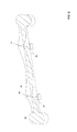
- a 3-dimensional landmark 60 is shown, the data set containing the data needed to display a 3-dimensional representation of the landmark.
- the landmark has four upright columns 61.
- the processing unit 12 when the processing unit 12 has identified the largest continuous horizontal surface of the 3-dimensional landmark, it stores the information of the surface as a road traffic area. The information is stored linked to the data set in such a way that a navigation system 20, e.g. a system as shown in Fig. 2 , can use the identified information to provide a 3-dimensional representation of a driving recommendation.
- the navigation system shown in Fig. 2 contains a navigation unit 21 which determines a route to a desired destination that may be input by a user of the navigation system 20 via an input unit 22.
- the way in which the navigation unit calculates a route to a desired destination is known to the skilled person and will not be explained in further detail.
- the navigation system furthermore contains a database 23 in which the data sets containing the 3-dimensional landmarks are stored together with the information about the road traffic area as identified as discussed above in connection with Fig. 1 .
- the database furthermore contains the map data needed to calculate and display a route to a desired destination.
- An image viewer 24 generates a displayed information to be displayed on a display 25.
- the image viewer may generate a 3-dimensional route guidance information where a section of the recommended route is shown in a 3-dimensional representation.
- a part of a driving route is shown in a 3-dimensional representation.
- the image viewer can retrieve, from the database and from a data set showing landmark 50, the road traffic area 51.
- the image viewer furthermore indicates a line 52 and 53, indicating the recommended route to the driver.
- the identified road traffic area 51 can then be displayed as part of the line representing the route.
- the road traffic area can be displayed with a special road texture, the texture of the road traffic area 51 can be the same as the texture for the parts of the route 52 and 53, however, it is also possible that a different texture is used for displaying the driving recommendation as shown in the example of Fig. 5 .
- Figs. 1 and 2 only the modules or components are shown which are needed for the understanding of the invention. It should be understood that the systems shown in Fig. 2 may contain additional components not shown. Furthermore, the components shown may be incorporated in less components or more components than shown in Figs. 1 and 2 . The components shown only represent the functions needed to realise the invention. The components shown may be incorporated by software or by hardware or by a combination of software and hardware.
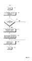
- Fig. 3 the method to process the 3-dimensional landmark to identify the road traffic area of the landmark is summarized.
- the method starts in step 31 and in step 32 the data set is provided to the processing unit.
- step 33 the largest horizontal continuous surface is determined.
- One possibility to determine the horizontal surface was described above by identifying the normal vectors having a vertical upright orientation and by identifying the corresponding faces which build a continuous horizontal surface.
- any other method might be used to identify in the data set of the 3-dimensional landmark the largest continuous horizontal surface.
- this surface is stored in step 34 as the road traffic area used by a vehicle for driving. This information may be stored as an attribute of the data set of the 3-dimensional landmark.
- the method ends in step 35.
- step 41 the driving route is determined.
- the determined driving route can either be a driving route calculated to a desired destination, however, it is also possible that the driver did not input a desired destination but simply used the navigation system to display the currently used route and to e.g. warn the driver of traffic congestions displayed on the display together with the current position of the vehicle.
- step 43 it is determined whether a 3-dimensional landmark that is part of the driving route is located on the current driving route.
- step 46 the 3-dimensional driving recommendation is displayed as a 3-dimensional road map. If the 3-dimensional landmark is located on the route, the 3-dimensional landmark is displayed together with the road traffic area as shown in Fig. 5 . If it is determined in step 43 that no landmark is located along the route, the 3-dimensional driving recommendation is displayed by simply displaying a 3-dimensional view of the road map. The method ends in step 47.
- the invention allows 3-dimensional landmarks to be included into 3-dimensional driving recommendations displayed to a vehicle driver or to a pedestrian.
Landscapes
- Engineering & Computer Science (AREA)
- Radar, Positioning & Navigation (AREA)
- Remote Sensing (AREA)
- Physics & Mathematics (AREA)
- Automation & Control Theory (AREA)
- General Physics & Mathematics (AREA)
- Geometry (AREA)
- Computer Graphics (AREA)
- Theoretical Computer Science (AREA)
- Navigation (AREA)
- Instructional Devices (AREA)
Priority Applications (3)
| Application Number | Priority Date | Filing Date | Title |
|---|---|---|---|
| EP11175431.3A EP2543964B1 (fr) | 2011-07-06 | 2011-07-26 | Surface de route d'un repère tridimensionnel |
| US13/543,230 US9891066B2 (en) | 2011-07-06 | 2012-07-06 | System for displaying a three-dimensional landmark |
| US14/501,728 US9903731B2 (en) | 2011-07-06 | 2014-09-30 | System for displaying a three-dimensional landmark |
Applications Claiming Priority (2)
| Application Number | Priority Date | Filing Date | Title |
|---|---|---|---|
| EP11172910 | 2011-07-06 | ||
| EP11175431.3A EP2543964B1 (fr) | 2011-07-06 | 2011-07-26 | Surface de route d'un repère tridimensionnel |
Publications (2)
| Publication Number | Publication Date |
|---|---|
| EP2543964A1 true EP2543964A1 (fr) | 2013-01-09 |
| EP2543964B1 EP2543964B1 (fr) | 2015-09-02 |
Family
ID=44675982
Family Applications (1)
| Application Number | Title | Priority Date | Filing Date |
|---|---|---|---|
| EP11175431.3A Active EP2543964B1 (fr) | 2011-07-06 | 2011-07-26 | Surface de route d'un repère tridimensionnel |
Country Status (2)
| Country | Link |
|---|---|
| US (2) | US9891066B2 (fr) |
| EP (1) | EP2543964B1 (fr) |
Families Citing this family (4)
| Publication number | Priority date | Publication date | Assignee | Title |
|---|---|---|---|---|
| EP2543964B1 (fr) | 2011-07-06 | 2015-09-02 | Harman Becker Automotive Systems GmbH | Surface de route d'un repère tridimensionnel |
| RU196356U1 (ru) * | 2019-09-23 | 2020-02-26 | Общество с ограниченной ответственностью "Нейро-Сити" | Интерактивное устройство отображения информации пользователю |
| CN113850907B (zh) * | 2020-06-28 | 2025-06-06 | 浙江宇视科技有限公司 | 一种路网信息提取方法、装置、电子设备和存储介质 |
| US11725959B2 (en) | 2020-11-13 | 2023-08-15 | Nvidia Corporation | Automatic graphical content recognition for vehicle applications |
Citations (5)
| Publication number | Priority date | Publication date | Assignee | Title |
|---|---|---|---|---|
| EP1650725A1 (fr) * | 2003-07-30 | 2006-04-26 | Olympus Corporation | Ensemble support a deplacement securise |
| EP1739643A1 (fr) * | 2004-04-21 | 2007-01-03 | Mitsubishi Denki Kabushiki Kaisha | Dispositif d"affichage d"installations |
| EP1752948A1 (fr) * | 2004-03-31 | 2007-02-14 | Pioneer Corporation | Dispositif de création d'informations de carte, méthode de création d'informations de carte et programme de création d'informations de carte |
| EP1798704A2 (fr) * | 1997-10-27 | 2007-06-20 | Matsushita Electric Industrial Co., Ltd. | Dispositif d'affichage tridimensionnel de cartes et son dispositif de création |
| US20080228393A1 (en) * | 2007-01-10 | 2008-09-18 | Pieter Geelen | Navigation device and method |
Family Cites Families (25)
| Publication number | Priority date | Publication date | Assignee | Title |
|---|---|---|---|---|
| US5179638A (en) * | 1990-04-26 | 1993-01-12 | Honeywell Inc. | Method and apparatus for generating a texture mapped perspective view |
| DE19801801C2 (de) * | 1997-01-20 | 2000-06-29 | Nissan Motor | Navigationssystem und Speichermedium für das Speichern dafür verwendeter Betriebsprogramme |
| DE19920709A1 (de) * | 1999-05-05 | 2000-11-16 | Siemens Ag | Verfahren zum Gewinnen einer dreidimensionalen Kartendarstellung und Navigationssystem |
| DE59908421D1 (de) * | 1999-05-21 | 2004-03-04 | Siemens Ag | Verfahren zum Gewinnen einer dreidimensionalen Kartendarstellung und Navigationssystem |
| JP3717045B2 (ja) * | 2000-01-19 | 2005-11-16 | 松下電器産業株式会社 | ナビゲーション装置 |
| JP3475142B2 (ja) * | 2000-03-01 | 2003-12-08 | 三菱電機株式会社 | 地図データ送信装置、地図データ送信方法、及び、地図データ送信方法をコンピュータに実行させるためのプログラムを記録したコンピュータ読み取り可能な記録媒体 |
| JP3816299B2 (ja) * | 2000-04-28 | 2006-08-30 | パイオニア株式会社 | ナビゲーションシステム |
| EP1311802A1 (fr) * | 2000-08-24 | 2003-05-21 | Siemens Aktiengesellschaft | Procede permettant d'obtenir une representation cartographique, et appareil de navigation y relatif |
| JP4077400B2 (ja) * | 2002-12-26 | 2008-04-16 | 株式会社東芝 | 案内情報提供装置、サーバー装置、案内情報提供方法、及びコンピュータに案内情報提供を実行させるためのプログラム |
| WO2006092853A1 (fr) * | 2005-03-02 | 2006-09-08 | Navitime Japan Co., Ltd. | Dispositif et procede d’affichage de carte |
| US8626440B2 (en) * | 2005-04-18 | 2014-01-07 | Navteq B.V. | Data-driven 3D traffic views with the view based on user-selected start and end geographical locations |
| JP4577327B2 (ja) * | 2007-04-09 | 2010-11-10 | 株式会社デンソー | 地図表示制御装置および地図表示制御装置用のプログラム |
| WO2009131108A1 (fr) * | 2008-04-23 | 2009-10-29 | 株式会社パスコ | Dispositif, procédé et programme de reconnaissance de contour de toit de bâtiment |
| KR101085390B1 (ko) * | 2008-04-30 | 2011-11-21 | 주식회사 코아로직 | 3d 네비게이션을 위한 영상표현 방법, 장치 및 그 장치를포함한 모바일 장치 |
| JP2011529568A (ja) * | 2008-07-31 | 2011-12-08 | テレ アトラス ベスローテン フエンノートシャップ | ナビゲーションデータを三次元で表示する方法 |
| US9098926B2 (en) * | 2009-02-06 | 2015-08-04 | The Hong Kong University Of Science And Technology | Generating three-dimensional façade models from images |
| EP2244242A1 (fr) * | 2009-04-23 | 2010-10-27 | Wayfinder Systems AB | Procédé et dispositif pour améliorer la navigation |
| US8532924B2 (en) * | 2009-09-02 | 2013-09-10 | Alpine Electronics, Inc. | Method and apparatus for displaying three-dimensional terrain and route guidance |
| US8306672B2 (en) * | 2009-09-09 | 2012-11-06 | GM Global Technology Operations LLC | Vehicular terrain detection system and method |
| US8471732B2 (en) * | 2009-12-14 | 2013-06-25 | Robert Bosch Gmbh | Method for re-using photorealistic 3D landmarks for nonphotorealistic 3D maps |
| US20110144909A1 (en) * | 2009-12-14 | 2011-06-16 | Robert Bosch Gmbh | Personalized and context-sensitive 3d route guidance |
| US20110153198A1 (en) * | 2009-12-21 | 2011-06-23 | Navisus LLC | Method for the display of navigation instructions using an augmented-reality concept |
| US8498812B2 (en) * | 2010-01-05 | 2013-07-30 | Robert Bosch Gmbh | Stylized procedural modeling for 3D navigation |
| US20110288763A1 (en) * | 2010-05-18 | 2011-11-24 | Alpine Electronics, Inc. | Method and apparatus for displaying three-dimensional route guidance |
| EP2543964B1 (fr) | 2011-07-06 | 2015-09-02 | Harman Becker Automotive Systems GmbH | Surface de route d'un repère tridimensionnel |
-
2011
- 2011-07-26 EP EP11175431.3A patent/EP2543964B1/fr active Active
-
2012
- 2012-07-06 US US13/543,230 patent/US9891066B2/en active Active
-
2014
- 2014-09-30 US US14/501,728 patent/US9903731B2/en active Active
Patent Citations (5)
| Publication number | Priority date | Publication date | Assignee | Title |
|---|---|---|---|---|
| EP1798704A2 (fr) * | 1997-10-27 | 2007-06-20 | Matsushita Electric Industrial Co., Ltd. | Dispositif d'affichage tridimensionnel de cartes et son dispositif de création |
| EP1650725A1 (fr) * | 2003-07-30 | 2006-04-26 | Olympus Corporation | Ensemble support a deplacement securise |
| EP1752948A1 (fr) * | 2004-03-31 | 2007-02-14 | Pioneer Corporation | Dispositif de création d'informations de carte, méthode de création d'informations de carte et programme de création d'informations de carte |
| EP1739643A1 (fr) * | 2004-04-21 | 2007-01-03 | Mitsubishi Denki Kabushiki Kaisha | Dispositif d"affichage d"installations |
| US20080228393A1 (en) * | 2007-01-10 | 2008-09-18 | Pieter Geelen | Navigation device and method |
Non-Patent Citations (1)
| Title |
|---|
| ARNE SCHILLING, SANDRA LANIG, PASCAL NEIS AND ALEXANDER ZIPF: "Integrating Terrain Surface and Street Network for 3D Routing", 3D GEOINFO 08, 3RD INTERNATIONALWORKSHOP ON 3D GEO-INFORMATION, November 2008 (2008-11-01), Seoul, South Korea, XP002660659 * |
Also Published As
| Publication number | Publication date |
|---|---|
| EP2543964B1 (fr) | 2015-09-02 |
| US20130179069A1 (en) | 2013-07-11 |
| US20150081204A1 (en) | 2015-03-19 |
| US9891066B2 (en) | 2018-02-13 |
| US9903731B2 (en) | 2018-02-27 |
Similar Documents
| Publication | Publication Date | Title |
|---|---|---|
| CN112204343B (zh) | 高清晰地图数据的可视化 | |
| US8725411B2 (en) | 3D tunnel representation | |
| JP4679182B2 (ja) | 地図表示方法、地図表示プログラムおよび地図表示装置 | |
| US8040343B2 (en) | Map display device and map display method | |
| EP3667239A1 (fr) | Procédé et appareil à réalité augmentée basés sur la localisation et les conditions environnementales | |
| EP2503292B1 (fr) | Icônes de repère sur cartes numériques | |
| EP3671623A1 (fr) | Procédé, appareil et produit de programme informatique pour la génération d'une vue aérienne d'un environnement à partir d'une image en perspective | |
| US11288785B2 (en) | Virtual overlay system and method for occluded objects | |
| US20100070162A1 (en) | Navigation system, mobile terminal device, and route guiding method | |
| EP4089370B1 (fr) | Procédé et dispositif pour vérifier la localisation et l'orientation actuelles d'un utilisateur à l'aide de repères | |
| US20060224311A1 (en) | Navigation system | |
| US9549169B2 (en) | Stereoscopic map display system | |
| JP2012073397A (ja) | 3次元地図表示システム | |
| CN111373223A (zh) | 用于显示增强现实导航信息的方法、装置和系统 | |
| EP2980776B1 (fr) | Système, procédé et programme pour un affichage de sites | |
| KR102871421B1 (ko) | 컨텐츠를 시각화하는 장치 및 방법 | |
| CN105474269A (zh) | 立体地图显示系统 | |
| JP5883723B2 (ja) | 3次元画像表示システム | |
| EP2543964B1 (fr) | Surface de route d'un repère tridimensionnel | |
| KR20150132178A (ko) | 3차원 지도 표시 장치 | |
| CN120427027B (zh) | 车辆增强现实导航方法、增强现实抬头显示装置及车辆 | |
| TWI426237B (zh) | Instant image navigation system and method | |
| CN101163943B (zh) | 用于三维显示数字公路图的方法 | |
| EP2816531A1 (fr) | Vue cartographique tridimensionnelle avec des images de fond | |
| JP5232380B2 (ja) | 地図表示装置 |
Legal Events
| Date | Code | Title | Description |
|---|---|---|---|
| PUAI | Public reference made under article 153(3) epc to a published international application that has entered the european phase |
Free format text: ORIGINAL CODE: 0009012 |
|
| AK | Designated contracting states |
Kind code of ref document: A1 Designated state(s): AL AT BE BG CH CY CZ DE DK EE ES FI FR GB GR HR HU IE IS IT LI LT LU LV MC MK MT NL NO PL PT RO RS SE SI SK SM TR |
|
| AX | Request for extension of the european patent |
Extension state: BA ME |
|
| 17P | Request for examination filed |
Effective date: 20130705 |
|
| GRAP | Despatch of communication of intention to grant a patent |
Free format text: ORIGINAL CODE: EPIDOSNIGR1 |
|
| INTG | Intention to grant announced |
Effective date: 20150213 |
|
| GRAS | Grant fee paid |
Free format text: ORIGINAL CODE: EPIDOSNIGR3 |
|
| GRAA | (expected) grant |
Free format text: ORIGINAL CODE: 0009210 |
|
| AK | Designated contracting states |
Kind code of ref document: B1 Designated state(s): AL AT BE BG CH CY CZ DE DK EE ES FI FR GB GR HR HU IE IS IT LI LT LU LV MC MK MT NL NO PL PT RO RS SE SI SK SM TR |
|
| REG | Reference to a national code |
Ref country code: GB Ref legal event code: FG4D |
|
| REG | Reference to a national code |
Ref country code: AT Ref legal event code: REF Ref document number: 746896 Country of ref document: AT Kind code of ref document: T Effective date: 20150915 Ref country code: CH Ref legal event code: EP |
|
| REG | Reference to a national code |
Ref country code: IE Ref legal event code: FG4D |
|
| REG | Reference to a national code |
Ref country code: DE Ref legal event code: R096 Ref document number: 602011019319 Country of ref document: DE |
|
| REG | Reference to a national code |
Ref country code: AT Ref legal event code: MK05 Ref document number: 746896 Country of ref document: AT Kind code of ref document: T Effective date: 20150902 |
|
| PG25 | Lapsed in a contracting state [announced via postgrant information from national office to epo] |
Ref country code: LT Free format text: LAPSE BECAUSE OF FAILURE TO SUBMIT A TRANSLATION OF THE DESCRIPTION OR TO PAY THE FEE WITHIN THE PRESCRIBED TIME-LIMIT Effective date: 20150902 Ref country code: NO Free format text: LAPSE BECAUSE OF FAILURE TO SUBMIT A TRANSLATION OF THE DESCRIPTION OR TO PAY THE FEE WITHIN THE PRESCRIBED TIME-LIMIT Effective date: 20151202 Ref country code: GR Free format text: LAPSE BECAUSE OF FAILURE TO SUBMIT A TRANSLATION OF THE DESCRIPTION OR TO PAY THE FEE WITHIN THE PRESCRIBED TIME-LIMIT Effective date: 20151203 Ref country code: LV Free format text: LAPSE BECAUSE OF FAILURE TO SUBMIT A TRANSLATION OF THE DESCRIPTION OR TO PAY THE FEE WITHIN THE PRESCRIBED TIME-LIMIT Effective date: 20150902 Ref country code: FI Free format text: LAPSE BECAUSE OF FAILURE TO SUBMIT A TRANSLATION OF THE DESCRIPTION OR TO PAY THE FEE WITHIN THE PRESCRIBED TIME-LIMIT Effective date: 20150902 |
|
| REG | Reference to a national code |
Ref country code: LT Ref legal event code: MG4D Ref country code: NL Ref legal event code: MP Effective date: 20150902 |
|
| PG25 | Lapsed in a contracting state [announced via postgrant information from national office to epo] |
Ref country code: SE Free format text: LAPSE BECAUSE OF FAILURE TO SUBMIT A TRANSLATION OF THE DESCRIPTION OR TO PAY THE FEE WITHIN THE PRESCRIBED TIME-LIMIT Effective date: 20150902 Ref country code: ES Free format text: LAPSE BECAUSE OF FAILURE TO SUBMIT A TRANSLATION OF THE DESCRIPTION OR TO PAY THE FEE WITHIN THE PRESCRIBED TIME-LIMIT Effective date: 20150902 Ref country code: RS Free format text: LAPSE BECAUSE OF FAILURE TO SUBMIT A TRANSLATION OF THE DESCRIPTION OR TO PAY THE FEE WITHIN THE PRESCRIBED TIME-LIMIT Effective date: 20150902 Ref country code: AT Free format text: LAPSE BECAUSE OF FAILURE TO SUBMIT A TRANSLATION OF THE DESCRIPTION OR TO PAY THE FEE WITHIN THE PRESCRIBED TIME-LIMIT Effective date: 20150902 Ref country code: PL Free format text: LAPSE BECAUSE OF FAILURE TO SUBMIT A TRANSLATION OF THE DESCRIPTION OR TO PAY THE FEE WITHIN THE PRESCRIBED TIME-LIMIT Effective date: 20150902 |
|
| PG25 | Lapsed in a contracting state [announced via postgrant information from national office to epo] |
Ref country code: CZ Free format text: LAPSE BECAUSE OF FAILURE TO SUBMIT A TRANSLATION OF THE DESCRIPTION OR TO PAY THE FEE WITHIN THE PRESCRIBED TIME-LIMIT Effective date: 20150902 Ref country code: NL Free format text: LAPSE BECAUSE OF FAILURE TO SUBMIT A TRANSLATION OF THE DESCRIPTION OR TO PAY THE FEE WITHIN THE PRESCRIBED TIME-LIMIT Effective date: 20150902 Ref country code: IT Free format text: LAPSE BECAUSE OF FAILURE TO SUBMIT A TRANSLATION OF THE DESCRIPTION OR TO PAY THE FEE WITHIN THE PRESCRIBED TIME-LIMIT Effective date: 20150902 Ref country code: SK Free format text: LAPSE BECAUSE OF FAILURE TO SUBMIT A TRANSLATION OF THE DESCRIPTION OR TO PAY THE FEE WITHIN THE PRESCRIBED TIME-LIMIT Effective date: 20150902 Ref country code: IS Free format text: LAPSE BECAUSE OF FAILURE TO SUBMIT A TRANSLATION OF THE DESCRIPTION OR TO PAY THE FEE WITHIN THE PRESCRIBED TIME-LIMIT Effective date: 20160102 Ref country code: EE Free format text: LAPSE BECAUSE OF FAILURE TO SUBMIT A TRANSLATION OF THE DESCRIPTION OR TO PAY THE FEE WITHIN THE PRESCRIBED TIME-LIMIT Effective date: 20150902 |
|
| PG25 | Lapsed in a contracting state [announced via postgrant information from national office to epo] |
Ref country code: RO Free format text: LAPSE BECAUSE OF FAILURE TO SUBMIT A TRANSLATION OF THE DESCRIPTION OR TO PAY THE FEE WITHIN THE PRESCRIBED TIME-LIMIT Effective date: 20150902 Ref country code: PT Free format text: LAPSE BECAUSE OF FAILURE TO SUBMIT A TRANSLATION OF THE DESCRIPTION OR TO PAY THE FEE WITHIN THE PRESCRIBED TIME-LIMIT Effective date: 20160104 |
|
| REG | Reference to a national code |
Ref country code: DE Ref legal event code: R097 Ref document number: 602011019319 Country of ref document: DE |
|
| PLBE | No opposition filed within time limit |
Free format text: ORIGINAL CODE: 0009261 |
|
| STAA | Information on the status of an ep patent application or granted ep patent |
Free format text: STATUS: NO OPPOSITION FILED WITHIN TIME LIMIT |
|
| 26N | No opposition filed |
Effective date: 20160603 |
|
| PG25 | Lapsed in a contracting state [announced via postgrant information from national office to epo] |
Ref country code: SI Free format text: LAPSE BECAUSE OF FAILURE TO SUBMIT A TRANSLATION OF THE DESCRIPTION OR TO PAY THE FEE WITHIN THE PRESCRIBED TIME-LIMIT Effective date: 20150902 Ref country code: DK Free format text: LAPSE BECAUSE OF FAILURE TO SUBMIT A TRANSLATION OF THE DESCRIPTION OR TO PAY THE FEE WITHIN THE PRESCRIBED TIME-LIMIT Effective date: 20150902 |
|
| PG25 | Lapsed in a contracting state [announced via postgrant information from national office to epo] |
Ref country code: BE Free format text: LAPSE BECAUSE OF FAILURE TO SUBMIT A TRANSLATION OF THE DESCRIPTION OR TO PAY THE FEE WITHIN THE PRESCRIBED TIME-LIMIT Effective date: 20150902 |
|
| REG | Reference to a national code |
Ref country code: CH Ref legal event code: PL |
|
| PG25 | Lapsed in a contracting state [announced via postgrant information from national office to epo] |
Ref country code: MC Free format text: LAPSE BECAUSE OF FAILURE TO SUBMIT A TRANSLATION OF THE DESCRIPTION OR TO PAY THE FEE WITHIN THE PRESCRIBED TIME-LIMIT Effective date: 20150902 |
|
| PG25 | Lapsed in a contracting state [announced via postgrant information from national office to epo] |
Ref country code: FR Free format text: LAPSE BECAUSE OF NON-PAYMENT OF DUE FEES Effective date: 20160801 Ref country code: CH Free format text: LAPSE BECAUSE OF NON-PAYMENT OF DUE FEES Effective date: 20160731 Ref country code: LI Free format text: LAPSE BECAUSE OF NON-PAYMENT OF DUE FEES Effective date: 20160731 |
|
| REG | Reference to a national code |
Ref country code: FR Ref legal event code: ST Effective date: 20170331 |
|
| REG | Reference to a national code |
Ref country code: IE Ref legal event code: MM4A |
|
| PG25 | Lapsed in a contracting state [announced via postgrant information from national office to epo] |
Ref country code: IE Free format text: LAPSE BECAUSE OF NON-PAYMENT OF DUE FEES Effective date: 20160726 |
|
| PG25 | Lapsed in a contracting state [announced via postgrant information from national office to epo] |
Ref country code: LU Free format text: LAPSE BECAUSE OF NON-PAYMENT OF DUE FEES Effective date: 20160726 |
|
| PG25 | Lapsed in a contracting state [announced via postgrant information from national office to epo] |
Ref country code: SM Free format text: LAPSE BECAUSE OF FAILURE TO SUBMIT A TRANSLATION OF THE DESCRIPTION OR TO PAY THE FEE WITHIN THE PRESCRIBED TIME-LIMIT Effective date: 20150902 Ref country code: CY Free format text: LAPSE BECAUSE OF FAILURE TO SUBMIT A TRANSLATION OF THE DESCRIPTION OR TO PAY THE FEE WITHIN THE PRESCRIBED TIME-LIMIT Effective date: 20150902 Ref country code: HU Free format text: LAPSE BECAUSE OF FAILURE TO SUBMIT A TRANSLATION OF THE DESCRIPTION OR TO PAY THE FEE WITHIN THE PRESCRIBED TIME-LIMIT; INVALID AB INITIO Effective date: 20110726 |
|
| PG25 | Lapsed in a contracting state [announced via postgrant information from national office to epo] |
Ref country code: MT Free format text: LAPSE BECAUSE OF NON-PAYMENT OF DUE FEES Effective date: 20160731 Ref country code: HR Free format text: LAPSE BECAUSE OF FAILURE TO SUBMIT A TRANSLATION OF THE DESCRIPTION OR TO PAY THE FEE WITHIN THE PRESCRIBED TIME-LIMIT Effective date: 20150902 Ref country code: MK Free format text: LAPSE BECAUSE OF FAILURE TO SUBMIT A TRANSLATION OF THE DESCRIPTION OR TO PAY THE FEE WITHIN THE PRESCRIBED TIME-LIMIT Effective date: 20150902 Ref country code: TR Free format text: LAPSE BECAUSE OF FAILURE TO SUBMIT A TRANSLATION OF THE DESCRIPTION OR TO PAY THE FEE WITHIN THE PRESCRIBED TIME-LIMIT Effective date: 20150902 |
|
| PG25 | Lapsed in a contracting state [announced via postgrant information from national office to epo] |
Ref country code: BG Free format text: LAPSE BECAUSE OF FAILURE TO SUBMIT A TRANSLATION OF THE DESCRIPTION OR TO PAY THE FEE WITHIN THE PRESCRIBED TIME-LIMIT Effective date: 20150902 |
|
| PG25 | Lapsed in a contracting state [announced via postgrant information from national office to epo] |
Ref country code: AL Free format text: LAPSE BECAUSE OF FAILURE TO SUBMIT A TRANSLATION OF THE DESCRIPTION OR TO PAY THE FEE WITHIN THE PRESCRIBED TIME-LIMIT Effective date: 20150902 |
|
| PGFP | Annual fee paid to national office [announced via postgrant information from national office to epo] |
Ref country code: ES Payment date: 20180903 Year of fee payment: 12 |
|
| GBPC | Gb: european patent ceased through non-payment of renewal fee |
Effective date: 20190726 |
|
| PG25 | Lapsed in a contracting state [announced via postgrant information from national office to epo] |
Ref country code: GB Free format text: LAPSE BECAUSE OF NON-PAYMENT OF DUE FEES Effective date: 20190726 |
|
| P01 | Opt-out of the competence of the unified patent court (upc) registered |
Effective date: 20230526 |
|
| PGFP | Annual fee paid to national office [announced via postgrant information from national office to epo] |
Ref country code: DE Payment date: 20250620 Year of fee payment: 15 |