EP2637152A1 - Kartenanzeigevorrichtung, kartenanzeigeverfahren und kartenanzeigeprogramm - Google Patents
Kartenanzeigevorrichtung, kartenanzeigeverfahren und kartenanzeigeprogramm Download PDFInfo
- Publication number
- EP2637152A1 EP2637152A1 EP11846744.8A EP11846744A EP2637152A1 EP 2637152 A1 EP2637152 A1 EP 2637152A1 EP 11846744 A EP11846744 A EP 11846744A EP 2637152 A1 EP2637152 A1 EP 2637152A1
- Authority
- EP
- European Patent Office
- Prior art keywords
- traffic signal
- map
- display
- displaying
- information
- Prior art date
- Legal status (The legal status is an assumption and is not a legal conclusion. Google has not performed a legal analysis and makes no representation as to the accuracy of the status listed.)
- Ceased
Links
- 238000000034 method Methods 0.000 title claims description 21
- 238000010586 diagram Methods 0.000 description 17
- 230000007423 decrease Effects 0.000 description 2
- 230000000694 effects Effects 0.000 description 1
- 230000006870 function Effects 0.000 description 1
- 230000005484 gravity Effects 0.000 description 1
- 230000010354 integration Effects 0.000 description 1
- 239000004973 liquid crystal related substance Substances 0.000 description 1
- 230000003287 optical effect Effects 0.000 description 1
Images


Classifications
-
- G—PHYSICS
- G01—MEASURING; TESTING
- G01C—MEASURING DISTANCES, LEVELS OR BEARINGS; SURVEYING; NAVIGATION; GYROSCOPIC INSTRUMENTS; PHOTOGRAMMETRY OR VIDEOGRAMMETRY
- G01C21/00—Navigation; Navigational instruments not provided for in groups G01C1/00 - G01C19/00
- G01C21/26—Navigation; Navigational instruments not provided for in groups G01C1/00 - G01C19/00 specially adapted for navigation in a road network
- G01C21/34—Route searching; Route guidance
- G01C21/36—Input/output arrangements for on-board computers
- G01C21/3626—Details of the output of route guidance instructions
- G01C21/3658—Lane guidance
-
- G—PHYSICS
- G08—SIGNALLING
- G08G—TRAFFIC CONTROL SYSTEMS
- G08G1/00—Traffic control systems for road vehicles
- G08G1/09—Arrangements for giving variable traffic instructions
- G08G1/0962—Arrangements for giving variable traffic instructions having an indicator mounted inside the vehicle, e.g. giving voice messages
- G08G1/09626—Arrangements for giving variable traffic instructions having an indicator mounted inside the vehicle, e.g. giving voice messages where the origin of the information is within the own vehicle, e.g. a local storage device, digital map
Definitions
- the present invention relates to a map display apparatus, a map display method, and a map display program, which are used for a navigation device and the like.
- a navigation device which is generally mounted on a vehicle or the like grasps a position of the vehicle using a GPS (Global Positioning System), and guides a route to a destination which is instructed by a user.
- a typical navigation device performs a displaying of the vehicle position, the guiding of the route, and the like using a map display apparatus mounted in the navigation device.
- the map display apparatus reads out map data on the requested region from a recording unit in which the map data is recorded, generates map image data, and then displays the map image data in a display unit.
- a general map data used in the map display apparatus includes detailed city map data in which roads, traffic signals, buildings, and the like are recorded in detail as data, and simply digitized road network information by making intersections as nodes and the straight lines (links) connecting the nodes as roads.
- the map display apparatus performs the map displaying while appropriately switching a map displaying using the detailed city map data and another map displaying using the road network information. For example, when the detailed city map data is present in a target region of the map displaying, the map display apparatus basically performs the map displaying using the detailed city map data.
- a display scale of the requested map displaying is a broad display mode of which the scale exceeds an allowable range of the map displaying of the detailed city map data
- the map displaying is performed using the road network information instead of the detailed city map data.
- the detailed city map data is provided by only a part of an area of high population density zone but not covers all areas
- the map display apparatus performs the map displaying using the road network information.
- the traffic signal in the map displaying using the road network information is displayed depending on whether a node representing the intersection has attribute information of traffic signal available. In other words, when the node representing the intersection has the attribute information of traffic signal available, a traffic signal icon is displayed at the position of the node.
- wide roads as illustrated in FIG. 6A are not digitized using one link; for example, as illustrated in FIG. 6B , a plurality (two in FIG. 6B ) of links L, each of which is separated into an upper lane and a lower lane, may be digitized.
- the intersection between the roads digitized into two links L is constituted by four nodes denoted by " " in FIG. 6B .
- each of the four nodes has the attribute information of traffic signal available, and four traffic signal icons are displayed in one intersection.
- a plurality of traffic signal icons may be densely displayed or may be displayed in an overlapping manner depending on the display scale of the map displaying, and thus it may be difficult to grasp the map displaying.
- a user may misunderstand the intersection as a complex intersection, and thus it may be difficult to grasp the traffic signal positions and the road conditions.
- Patent Literature 1 discloses an invention relating to a display control method in which a representative icon is displayed instead of individual icons when a plurality of icons are displayed in an overlapping manner.
- Patent Literature 1 Japanese Laid-open Patent Publication No. 2001-125702
- the invention disclosed in Patent Literature 1 relates to icons representing stores, that is, icons of POI (Point of Interest), which is different in a displaying method from that of the traffic signal icon in the road network information.
- the representative icon is displayed when the icons are overlapped with each other.
- the traffic signal icon is different from the POI icon, and also includes auxiliary information for helping users to grasp the shape of the intersection. Therefore, when the representative icon is displayed only for the reason that the icons are overlapped, it may rather cause a difficulty in grasping the road conditions.
- the present invention has been made in view of the above problems, and an object of the present is to provide a map display apparatus, a map display method, and a map display program, in which the display mode of the traffic signal icon is switched according to the display scale to make the map displaying more visible.
- the present invention solves the above problems (1) by providing a map display apparatus 50 that includes: road network information 30b in which integrated traffic signal information is provided in an intersection configured of a plurality of nodes having attribute information of traffic signal available; a display unit 36 which performs map displaying using map image data generated based on the road network information 30b; and a signal displaying controller 38 which performs switching whether a traffic signal icon is displayed at the node of the map image data or the traffic signal icon is displayed at a position to display the integrated traffic signal information according to a display scale of the map displaying.
- the present invention solves the above problems (2) by providing a map display method: when a map displaying is performed based on road network information 30b in which integrated traffic signal information is provided in an intersection configured of a plurality of nodes having attribute information of traffic signal available, determining whether a display scale of the map displaying is equal to or higher than a predetermined value; and displaying a traffic signal icon at a position of the integrated traffic signal information to be represented when the display scale of the map displaying does not satisfy the predetermined value and displaying the traffic signal icon at a position of a node having the attribute information of traffic signal available when the display scale of the map displaying is equal to or higher than the predetermined value.
- the present invention solves the above problems (3) by providing a map display program which causes a computer to execute: when a map displaying is performed based on road network information 30b in which integrated traffic signal information is provided in an intersection configured of a plurality of nodes having attribute information of traffic signal available, determining whether a display scale of the map displaying is equal to or higher than a predetermined value; and displaying a traffic signal icon at a position of the integrated traffic signal information to be represented when the display scale of the map displaying does not satisfy the predetermined value and displaying the traffic signal icon at a position of a node having the attribute information of traffic signal available when the display scale of the map displaying is equal to or higher than the predetermined value.
- the present invention it is possible to make a map displaying more visible by switching a display mode of a traffic signal icon according to the display scale. Therefore, the traffic signal positions and the road conditions can be easily grasped.
- a map display apparatus, a map display method, and a map display program according to the present invention will be described with reference to the drawings. Further, the map display apparatus, the map display method, and the map display program according to the present invention are greatly advantageous in switching the display of a traffic signal icon. Therefore, the detailed descriptions about parts having no direct connection to the present invention will not be provided.
- a display scale to be described herein will be assumed as follows: when the display scale is set to 1/M, when the M value decreases, the display scale increases and a detailed display mode can be made; and when the M value increases, the display scale decreases and a broad display mode can be made.
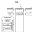
- a map display apparatus 50 illustrated in FIG. 1 includes: map data 30 which includes detailed city map data 30a and road network information 30b; a recording unit 32 in which the map data 30 is recorded; a map generating unit 34 which generates map image data based on the map data 30; a display unit 36 which performs a map displaying and the like using the map image data; a controller 10 which performs controls and various calculations for the respective components of the map display apparatus 50; a signal displaying controller 38 which switches the display mode of a traffic signal icon according to the display scale for the map displaying; a memory 12 which is used for various calculations by the controller 10 and the signal displaying controller 38; and an input unit 14 through which a user operates the map display apparatus 50.
- the signal displaying controller 38 may be configured as a part of the controller 10.
- the controller 10 when the map display apparatus 50 is mounted on a navigation device, the controller 10, the memory 12, the input unit 14 and the like may be commonly used by the navigation device.
- the recording unit 32 may include a known recording device which employs an optical recording medium such as a DVD (Digital Versatile Disc), a hard disk, and a non-volatile memory and the like.
- the display unit 36 may include a known displaying apparatus which employs a color liquid crystal, an organic EL display, or the like.
- the input unit 14 may include a known input apparatus which employs a touch panel, a voice input apparatus, a button input apparatus, and the like.
- an intersection between two roads may be considered, where each one of the roads is digitized using two links L.
- the intersection is configured to include four nodes Nd1 to Nd4 and intra-intersection links L' which connect these nodes Nd1 to Nd4.
- the intra-intersection links L' are links which connect nodes constituting the same intersection, to which attribute information different from that of the link L indicating the road is assigned.
- the road network information 30b has the attribute information of traffic signal available, and includes integrated traffic signal information in the intersection configured by a plurality of nodes.
- a link of which the nodes at both ends have the attribute information of traffic signal available is extracted.
- the attribute information of the extracted link is examined.
- the examined attribute information is the attribute information of the intra-intersection link L'
- other intra-intersection links L' which constitute the same intersection are extracted by tracing the intra-intersection link L'.
- all nodes which have the traffic signals Nd1 to Nd4 and connected to these intra-intersection links L' are extracted.
- the coordinates of the position G (denoted by "•" in FIG. 2A ) of a substantial gravity center is obtained based on the coordinates of the extracted nodes Nd1 to Nd4, and the integrated traffic signal information is assigned to the coordinates to display the traffic signal icon at the time of integration.
- a link is substantially the intra-intersection link but having no attribute information of the intra-intersection link.
- it is determined whether or not a plurality of nodes having the attribute information of traffic signal available are present in the same intersection, for example, based on the widths of the intersecting roads (the widths of the roads are analogized based on the lengths of the links and the number of links). Then, the integrated traffic signal information is assigned.
- map display apparatus 50 the map display method, and the map display program according to the present invention will be described using a flowchart of FIG. 3 .
- step S100 when the map displaying is requested by an operation through the input unit 14, a map display flow starts (step S100).
- the controller 10 determines whether or not the detailed city map data 30a in a region requested for the map displaying is present in the map data 30 (step S102). Then, when the detailed city map data 30a is not present (No in step S102), the process proceeds to step S110.
- the controller 10 determines whether or not the display scale of the requested map displaying is possible to make a map displaying using the detailed city map data 30a (step S104).
- step S110 when it is determined that the display scale is possible to make the map displaying using the detailed city map data 30a (Yes in step S104), the controller 10 causes the map generating unit 34 to create map image data based on the detailed city map data 30a, and causes the display unit 36 to make the map displaying based on the detailed city map data 30a (step S106). In this case, the traffic signal is displayed based on the detailed city map data 30a as in the past. Then, the process proceeds to step S200.
- the signal displaying controller 38 determines whether or not the display scale of the map displaying is equal to or higher than a predetermined value (step S110).
- the value of the display scale may be set to a specific fixed value, or may be differently set depending on the integrated traffic signal information to be described below.
- the signal displaying controller 38 switches the display mode of the traffic signal icon to display the traffic signal icon at a position of the integrated traffic signal information to be represented.
- the map generating unit 34 draws the traffic signal icon on the intersection not at the positions of the nodes having the traffic signals but at the position of the integrated traffic signal information to be represented.
- the display unit 36 performs the map displaying at the position of the integrated traffic signal information to be represented, based on the road network information 30b in which the traffic signal icon is displayed (step S112). Further, for the intersection in which the integrated traffic signal information is not present, the traffic signal icons are displayed at the positions of the nodes having the traffic signals.
- step S112 when the map displaying by step S112 is performed at the intersection illustrated in FIG. 2A ; as illustrated in FIG. 2B , a traffic signal icon is displayed at the position G of the integrated traffic signal information.
- the map displaying becomes more visible than that illustrated in FIG. 2C in which the traffic signal icons are displayed at all nodes Nd1 to Nd4 having the traffic signals. Therefore, it is possible to easily grasp the traffic signal positions and the road conditions.
- the signal displaying controller 38 switches the display mode of the traffic signal icon to display the traffic signal icons at the positions of the nodes having the traffic signals regardless of the integrated traffic signal information.
- the map generating unit 34 draws the traffic signal icons at the positions of the nodes having the traffic signals.
- the display unit 36 performs the map displaying based on the road network information 30b in which the traffic signal icons are displayed at the positions of the nodes having the traffic signals (step S114).
- the traffic signal icon When the traffic signal icon is displayed only at the position G of the integrated traffic signal information to be represented in the detailed display mode having a large display scale corresponding to step S114, a sense of discomfort may occur as illustrated in FIG. 2D , and thus it may be difficult to grasp the traffic signal positions and the road conditions. Therefore, in a case of the detailed display mode having the predetermined display scale or higher, as illustrated in FIG. 2E , the traffic signal icons are displayed at all nodes Nd1 to Nd4 having the attribute information of traffic signal available. With this configuration, even in a case of the detailed display mode, it is possible to more easily grasp the traffic signal positions and the road conditions.
- the traffic signal icon when the display position of the traffic signal icon is overlapped with a highway, the traffic signal icon may not be displayed or may be displayed by a translucent color, for example, in order to prevent the traffic signal icon from being displayed as if the traffic signal is present on the highway.
- step S200 when there is a request for ending the map displaying (Yes in step S200), the map display flow is ended (step S202) and the process proceeds to the next operation. In addition, when there is no request for ending the map displaying (No in step S200), the above-mentioned map display flow is repeated until the end request of the map displaying is issued.
- the map display program according to the present invention is particularly featured in that, as described above, the display scale of the map displaying is determined to cause a computer (the signal displaying controller 38) to execute a process of switching whether the traffic signal icons are displayed at the positions of the nodes having the traffic signals or the traffic signal icon is displayed at the position of the integrated traffic signal information to be represented.
- the display scale used to switch the display mode of the traffic signal icon may be fixed to a display scale such that the traffic signal position is appropriately grasped in both the broad display mode and the detailed display mode.
- the display scale may be differently set depending on the integrated traffic signal information.
- the display scale used to switch the display mode is set to a fixed value, the map display apparatus 50 is alleviated in load and thus performs the map displaying in a rapid manner.
- the display scale is differently set depending on the integrated traffic signal information, it is possible to display the traffic signal icons more visible according to the conditions of the respective intersections.
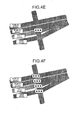
- the display scale is set according to the length of the intra-intersection link. For example, as illustrated in FIG. 4A , when there is an intra-intersection link having a relatively long distance in the same intersection, when the traffic signal icon is displayed in the detailed display mode based on the integrated traffic signal information as illustrated in FIG. 4B , it is difficult to grasp the traffic signal position and the road conditions.
- the display scale used to switch the display of the traffic signal is set to be relatively low such that the traffic signal icons are displayed at the nodes illustrated in FIG. 4C from at a some level of the broad display mode.
- the display scale is set according to the size of the intersection. For example, as illustrated in FIG. 4D , when an intersection of roads is very complicatedly configured by four lines, the length of the intra-intersection link is short but the intersection itself is long and large. As illustrated in FIG. 4E , if the traffic signal icon is displayed in the detailed display mode based on the integrated traffic signal information, it is difficult to grasp the traffic signal position and the road conditions. Therefore, in a relatively large intersection, the display scale used to switch the display of the traffic signal is set to be relatively low such that the traffic signal icons are displayed at the nodes illustrated in FIG. 4F from a relatively broader display mode.
- the display scale is set according to the number of nodes having the traffic signals which are present in the same intersection. For example, when there are nodes having a number of traffic signals in the same intersection as illustrated in FIG. 5A , when the display mode is a mode of displaying the traffic signal icon at each node, it is difficult to understand the map displaying as illustrated in FIG. 5B even though the display scale is for relatively detail displaying. Therefore, in a case of the intersection in which there are the nodes having a number of traffic signals, the display scale used to switch the display of the traffic signal is set to be relatively high such that the traffic signal icon is displayed based on the integrated traffic signal information illustrated in FIG.
- the display scale of switching the display of the traffic signal may be set to a maximum display scale so that the traffic signal icon is always displayed based on the integrated traffic signal information.
- the signal displaying controller 38 may perform the determination each time on the display scale used to switch the display of the traffic signal. Alternatively, the signal displaying controller 38 may perform the switching of the display mode as follows: once the display scale information used to switch the display of the traffic signal is recorded in a part of the integrated traffic signal information in advance, the signal displaying controller 38 reads out the display scale information of the integrated traffic signal information for the comparison with the display scale of the map displaying. Further, a plural pieces of the integrated traffic signal information having different values of the display scale information may be set in the same intersection, and the number of traffic signal icons to be displayed may increase in stages depending on the display scale of the map displaying.
- the display mode in which the traffic signal icon is displayed at the position of the node having the traffic signal and the display mode in which the traffic signal icon is displayed at the position of the integrated traffic signal information to be represented are switched according to the display scale of the map displaying.
- the broad display mode one traffic signal icon is displayed in the same intersection; in a case of the detailed display mode, a traffic signal icon is displayed at each one of the positions of the nodes having the traffic signals.
- the present invention includes programs which cause a computer to realize the functions of the map display apparatus 50. These programs may be read from another recording medium and installed in the computer, and alternatively may be transmitted through a communication network and installed in the computer.
- map display apparatus 50 since the map display apparatus 50, the map display method, and the map display program described above are merely examples. Therefore, operations, structures, procedures, and the like of the respective components are not limited thereto, and the present invention can be changed and implemented in a scope not departing from the spirit of the present invention.
Landscapes
- Engineering & Computer Science (AREA)
- Radar, Positioning & Navigation (AREA)
- Remote Sensing (AREA)
- Automation & Control Theory (AREA)
- Physics & Mathematics (AREA)
- General Physics & Mathematics (AREA)
- Navigation (AREA)
- Instructional Devices (AREA)
- User Interface Of Digital Computer (AREA)
Applications Claiming Priority (2)
| Application Number | Priority Date | Filing Date | Title |
|---|---|---|---|
| JP2010271095A JP5218534B2 (ja) | 2010-12-06 | 2010-12-06 | 地図表示装置、地図表示方法及び地図表示プログラム |
| PCT/JP2011/078042 WO2012077624A1 (ja) | 2010-12-06 | 2011-12-05 | 地図表示装置、地図表示方法及び地図表示プログラム |
Publications (2)
| Publication Number | Publication Date |
|---|---|
| EP2637152A1 true EP2637152A1 (de) | 2013-09-11 |
| EP2637152A4 EP2637152A4 (de) | 2014-11-19 |
Family
ID=46207112
Family Applications (1)
| Application Number | Title | Priority Date | Filing Date |
|---|---|---|---|
| EP20110846744 Ceased EP2637152A4 (de) | 2010-12-06 | 2011-12-05 | Kartenanzeigevorrichtung, kartenanzeigeverfahren und kartenanzeigeprogramm |
Country Status (4)
| Country | Link |
|---|---|
| US (1) | US9097540B2 (de) |
| EP (1) | EP2637152A4 (de) |
| JP (1) | JP5218534B2 (de) |
| WO (1) | WO2012077624A1 (de) |
Cited By (1)
| Publication number | Priority date | Publication date | Assignee | Title |
|---|---|---|---|---|
| US9454800B2 (en) | 2013-12-11 | 2016-09-27 | Thales | System for representing cartographic indications at multiple scales |
Families Citing this family (3)
| Publication number | Priority date | Publication date | Assignee | Title |
|---|---|---|---|---|
| CN109752009B (zh) * | 2017-11-03 | 2023-01-06 | 华为技术有限公司 | 路口区域路网数据生成方法及装置 |
| US11175157B1 (en) * | 2018-10-24 | 2021-11-16 | Palantir Technologies Inc. | Dynamic scaling of geospatial data on maps |
| CN112597259B (zh) * | 2020-12-17 | 2024-06-11 | 东南大学 | 一种基于区域综合交通网络拓扑重构的交通分配方法 |
Family Cites Families (8)
| Publication number | Priority date | Publication date | Assignee | Title |
|---|---|---|---|---|
| US5553209A (en) * | 1994-01-28 | 1996-09-03 | Hughes Aircraft Company | Method for automatically displaying map symbols |
| JP3220408B2 (ja) * | 1997-03-31 | 2001-10-22 | 富士通テン株式会社 | 経路案内装置 |
| JP3332225B2 (ja) * | 1998-11-24 | 2002-10-07 | 松下電器産業株式会社 | 地図提供システム |
| KR100443495B1 (ko) | 1998-11-24 | 2004-08-09 | 마쯔시다덴기산교 가부시키가이샤 | 디지털 지도파일의 데이터구조 |
| JP2001125702A (ja) | 1999-10-29 | 2001-05-11 | Nippon Telegraph & Telephone West Corp | 表示制御方法 |
| JP4329067B2 (ja) * | 2003-09-03 | 2009-09-09 | 株式会社デンソー | 車両用ナビゲーション装置 |
| JP4423114B2 (ja) * | 2004-06-02 | 2010-03-03 | アルパイン株式会社 | ナビゲーション装置およびその交差点案内方法 |
| JP2010156800A (ja) * | 2008-12-26 | 2010-07-15 | Toshiba Tec Corp | 地図情報表示装置、方法及びプログラム |
-
2010
- 2010-12-06 JP JP2010271095A patent/JP5218534B2/ja active Active
-
2011
- 2011-12-05 EP EP20110846744 patent/EP2637152A4/de not_active Ceased
- 2011-12-05 WO PCT/JP2011/078042 patent/WO2012077624A1/ja not_active Ceased
-
2013
- 2013-05-15 US US13/895,065 patent/US9097540B2/en active Active
Cited By (2)
| Publication number | Priority date | Publication date | Assignee | Title |
|---|---|---|---|---|
| US9454800B2 (en) | 2013-12-11 | 2016-09-27 | Thales | System for representing cartographic indications at multiple scales |
| EP2884231B1 (de) * | 2013-12-11 | 2018-11-07 | Thales | Kartendarstellungssystem mit mehrere Skalen |
Also Published As
| Publication number | Publication date |
|---|---|
| WO2012077624A1 (ja) | 2012-06-14 |
| US9097540B2 (en) | 2015-08-04 |
| US20130249938A1 (en) | 2013-09-26 |
| JP5218534B2 (ja) | 2013-06-26 |
| EP2637152A4 (de) | 2014-11-19 |
| JP2012123440A (ja) | 2012-06-28 |
Similar Documents
| Publication | Publication Date | Title |
|---|---|---|
| JP5590950B2 (ja) | ナビゲーション装置および誘導経路探索方法 | |
| US8099414B2 (en) | Facility information output device, facility information output method, and computer-readable medium storing facility information output program | |
| US20100088018A1 (en) | Glance ahead navigation | |
| JP4132741B2 (ja) | ナビゲーション装置 | |
| WO2014195406A1 (en) | Method for acquiring on-vehicle navigation information and on-vehicle navigation system | |
| US6311125B1 (en) | Road selecting and editing using shortest path tree | |
| JP6478864B2 (ja) | 電子装置、経路案内プログラムおよび経路案内システム | |
| EP2637152A1 (de) | Kartenanzeigevorrichtung, kartenanzeigeverfahren und kartenanzeigeprogramm | |
| EP2775262A1 (de) | Routenführung | |
| JP3597204B2 (ja) | ナビゲーション装置 | |
| JP6037758B2 (ja) | 案内地図作成装置、案内地図作成方法および案内地図作成プログラム | |
| US11885634B2 (en) | Display system and display program | |
| KR100841907B1 (ko) | 등급별 레이어를 적용한 지도 디스플레이 방법 및 그네비게이션 시스템 | |
| CN106372095B (zh) | 电子地图显示方法、装置及车载设备 | |
| JP6550796B2 (ja) | 情報案内システム | |
| EP4283259A1 (de) | Kartenanzeigesystem | |
| JP2008267820A (ja) | ナビゲーション装置及び施設案内方法 | |
| JPH0933275A (ja) | ナビゲーションシステム | |
| JP2006201072A (ja) | ナビゲーション装置 | |
| CN101600940B (zh) | 路径搜索装置、路径搜索方法 | |
| JP4817993B2 (ja) | ナビゲーション装置および誘導経路設定方法 | |
| KR100898263B1 (ko) | 경로 표시 단말기의 퀵서치 방법 및 장치 | |
| WO2011024509A1 (ja) | ナビゲーション装置 | |
| US20140039789A1 (en) | Dynamic progressive map granularity for navigation | |
| KR101061362B1 (ko) | 경로 요약정보 제공 장치 및 그 방법 |
Legal Events
| Date | Code | Title | Description |
|---|---|---|---|
| PUAI | Public reference made under article 153(3) epc to a published international application that has entered the european phase |
Free format text: ORIGINAL CODE: 0009012 |
|
| 17P | Request for examination filed |
Effective date: 20130603 |
|
| AK | Designated contracting states |
Kind code of ref document: A1 Designated state(s): AL AT BE BG CH CY CZ DE DK EE ES FI FR GB GR HR HU IE IS IT LI LT LU LV MC MK MT NL NO PL PT RO RS SE SI SK SM TR |
|
| DAX | Request for extension of the european patent (deleted) | ||
| RIC1 | Information provided on ipc code assigned before grant |
Ipc: G09B 29/00 20060101AFI20141008BHEP Ipc: G01C 21/26 20060101ALI20141008BHEP Ipc: G01C 21/36 20060101ALI20141008BHEP |
|
| A4 | Supplementary search report drawn up and despatched |
Effective date: 20141016 |
|
| 17Q | First examination report despatched |
Effective date: 20150729 |
|
| REG | Reference to a national code |
Ref country code: DE Ref legal event code: R003 |
|
| STAA | Information on the status of an ep patent application or granted ep patent |
Free format text: STATUS: THE APPLICATION HAS BEEN REFUSED |
|
| 18R | Application refused |
Effective date: 20160428 |