EP2747032A1 - Procédé de visualisation photoréaliste d'un ensemble de données tridimensionnelles de terrain en temps réel - Google Patents
Procédé de visualisation photoréaliste d'un ensemble de données tridimensionnelles de terrain en temps réel Download PDFInfo
- Publication number
- EP2747032A1 EP2747032A1 EP12199023.8A EP12199023A EP2747032A1 EP 2747032 A1 EP2747032 A1 EP 2747032A1 EP 12199023 A EP12199023 A EP 12199023A EP 2747032 A1 EP2747032 A1 EP 2747032A1
- Authority
- EP
- European Patent Office
- Prior art keywords
- cells
- resolution
- data
- mobile terminal
- display
- Prior art date
- Legal status (The legal status is an assumption and is not a legal conclusion. Google has not performed a legal analysis and makes no representation as to the accuracy of the status listed.)
- Withdrawn
Links
Images


Classifications
-
- G—PHYSICS
- G06—COMPUTING OR CALCULATING; COUNTING
- G06T—IMAGE DATA PROCESSING OR GENERATION, IN GENERAL
- G06T17/00—Three-dimensional [3D] modelling for computer graphics
- G06T17/005—Tree description, e.g. octree, quadtree
-
- G—PHYSICS
- G06—COMPUTING OR CALCULATING; COUNTING
- G06T—IMAGE DATA PROCESSING OR GENERATION, IN GENERAL
- G06T17/00—Three-dimensional [3D] modelling for computer graphics
- G06T17/05—Geographic models
-
- G—PHYSICS
- G06—COMPUTING OR CALCULATING; COUNTING
- G06T—IMAGE DATA PROCESSING OR GENERATION, IN GENERAL
- G06T2210/00—Indexing scheme for image generation or computer graphics
- G06T2210/36—Level of detail
Definitions
- the present invention relates to a method for photorealistic visualization of a three-dimensional terrain data set in real time on a mobile terminal. Furthermore, the present invention relates to a computer program for carrying out the method and a tablet PC or smartphone which is suitable for carrying out this method.
- GPS navigation devices There are already a variety of GPS navigation devices known. However, these are aimed primarily at navigation in traffic and usually give up completely on a realistic or even three-dimensional representation of the environment. Rather, these navigation devices are based on a relatively schematic map material. In addition, some specialized GPS navigation devices for outdoor use are known, for example, specialized in navigation during hiking or mountain biking. However, these devices are usually designed relatively simple and based on simple maps.
- mobile devices such as tablets and smartphones have improved so much that they, equipped with a corresponding program, can also serve as GPS navigation devices.
- these programs for mobile devices are usually based on relatively simple and schematic map material or aerial / satellite images (see, for example, Google Maps). If 3D geometries are used (see, for example, Google Earth), the representation is far removed from a photorealistic 3D representation, as only the rough terrain is reproduced.
- 3D geometries see, for example, Google Earth
- fundamentally technologies are known, by means of which a three-dimensional terrain data set can be photorealistically visualized.
- the implementation of such known methods on a mobile terminal with limited memory and processor capacity poses a great challenge.
- the present invention provides a method of photo-realistic visualization of a three-dimensional terrain data set in real time on a mobile terminal having a processor and a display.
- the data of the three-dimensional terrain data set are first processed hierarchically, wherein different hierarchical levels of the data are formed.
- the individual hierarchy levels each have different numbers of (data) cells, the cells of different hierarchy levels having different resolutions.
- a current camera angle i. a current camera point and a current camera viewing angle from this camera point.
- the cells relevant to the current camera perspective are determined, preferably by top-down traversal of the hierarchy levels.
- the different hierarchy levels are preferably run through recursively until the resolution of a particular cell of a particular hierarchy level is deemed sufficient in each case. Subsequently, those data assigned to the determined cells are transferred to the processor of the mobile terminal, which are not already present in the processor. Finally, the data associated with the detected cells is displayed on the display of the mobile terminal.
- the current camera point is understood to be a virtual point in three-dimensional space, from the perspective of which the user would like to have displayed the three-dimensional terrain. Under the current camera viewing angle, the viewing direction of the terrain is based on this virtual point in three-dimensional space and on to understand certain opening angles, which includes the terrain covered from this perspective.
- a visualization in real time means in the context of an interactive visualization, in which the current camera angle and / or the current camera viewing angle is changed by interaction of a user with the mobile terminal, a visualization of several images per second, preferably of at least five images per second, stronger preferably at least ten frames per second, and more preferably at least fifteen frames per second. Particularly preferred is a visualization of at least twenty images per second, so that the impression of a continuous movement arises.
- the cells of defined resolution relevant for the current camera viewing angle are preferably determined according to the invention in such a way that the resolution for a specific cell depends on how far away this cell is from the current camera point.
- the relevant cells of defined resolution are thereby preferably determined in such a way that overall a photo-realistic image can be displayed on the display of the mobile terminal.
- the three-dimensional terrain data set preferably has image data of the terrain and altitude profile information. These are preferably stereoscopic evaluations of aerial images and / or high-resolution surface models generated by lidar aerial surveys.
- the three-dimensional terrain data set is preferably a digital surface model which, in contrast to the digital terrain model, also contains data on construction, vegetation, etc.
- the method is preferably suitable for a resolution in the plane (sample density or raster resolution) of 100 cm or better, preferably 75 cm or better, more preferably 50 cm or better, even stronger preferably 25 cm or better and more preferably 10 cm or better. Further, in view of photo-realistic illustration, it is preferable that the method has a visualization with a height resolution of 100 cm or better, preferably 75 cm or better, more preferably 50 cm or better, still more preferably 25 cm or better and especially preferably 10 cm or better. Particularly preferably, a resolution in the plane and in the height profile of about 5 cm is achieved.
- the mobile terminal is preferably a tablet PC or smartphone and the relevant data is preferably loaded from a local storage, a server or the Internet.
- the three-dimensional terrain data set or the digital surface model is prepared in advance hierarchically.
- This process step preferably takes place on a central server or PC.
- the data of the three-dimensional terrain data set in the present original resolution ie as they are, for example, after eyelid or stereoscopic evaluation
- the data for aggregating the m cells is low-pass filtered into a single cell, where the m x n pixels of the m cells are processed into n pixels of the single cell.
- the cells are quadratic, wherein in each case 2 ⁇ 2 cells of a hierarchical level with a finer resolution are combined to form a single cell of a hierarchical level with a coarser resolution.
- a cell may preferably contain 32 ⁇ 32, 64 ⁇ 64, 128 ⁇ 128, 256 ⁇ 256 or 512 ⁇ 512 image pixels and / or height values.
- the elevation model For the geometric data of the digital surface model, it is preferable to first of all, for the elevation model, a triangular approximation with guaranteed quality at the finest detail level calculated. In this case, it is preferably ensured that the edge courses at the edges of adjacent cells are identical in each case. These triangular networks are then merged on the coarser levels of detail along their common edges to form a triangular mesh, which in turn is approximated more coarsely.
- the accuracy of the approximation is preferably chosen such that it coincides with the sampling density of the image data at every detail level.
- the method further comprises the step of detecting the current GPS position of the mobile terminal and displaying the current GPS position in the current camera perspective on the display.
- the current GPS position of the mobile terminal and thus of the user is implemented in the three-dimensional terrain representation of the current camera perspective.
- the terrain representation on the display represents a photo-realistic visualization of the environment, the user is much easier to match the situation shown on the display with its actual environment.
- additional information can also be displayed in the photorealistic representation of the terrain.
- hiking trails, mountain huts and / or restaurants, viewpoints and / or peaks can be marked in the visualization of the site.
- the user now wants to follow a certain trail or reach a certain vantage point, he does not have to laboriously reconcile his real environment with a schematic map, but can transfer the information provided in the photorealistic representation one-to-one to the surrounding reality. This greatly facilitates and improves the navigation in open terrain.
- navigation instructions are determined and graphically and / or acoustically passed on to the user on the basis of the detected GPS position and a navigation target specified by a user. This can be done, for example, by means of a path progression displayed in the photorealistic representation and / or a direction indication (for example by means of an arrow). It is further preferred that the GPS position is acquired and stored at different times, wherein a route formed by a plurality of stored GPS positions is displayed on the display at the current camera viewing angle. Both preferred Current routes that have just been completed are displayed as well as routes stored by this or another user at a different time.
- the user may access different basic data sets that, for example, show the terrain at different seasons. For example, a summer and a winter record can be stored, which can be accessed as needed. For example, the user can access the photorealistic representation of the summer landscape during a hike in summer and have the same terrain visualized as snow covered during a ski tour in winter.
- the current camera point and / or the current camera viewing angle starting from this camera point by interaction of a user with the mobile terminal, preferably by interaction of a user with the display of the mobile terminal, set and changed in real time.
- This can be done using operator icons and / or a keyboard.
- the interaction preferably takes place with the aid of finger gestures on a touch screen of the mobile terminal.
- the data shown on the display are preferably updated in real time.
- the present invention further relates to a computer program, in particular an app for a tablet PC or a smartphone, for carrying out the method described above. Furthermore, the present invention relates to a tablet PC or a smartphone which is suitable to carry out the method described above.
- the present invention makes it possible to visualize very large (in principle arbitrarily large) photorealistic 3D data sets.
- the invention is based, inter alia, on a hierarchical LOD (level of detail) technology. It will be after an automated preprocessing the datasets load the relevant data for the current view into the viewer, and only in the resolution necessary for the view. The loading takes place either from the local memory or over the Internet.
- the efficient compression as well as the cashing and the scalability of the views allow any size 3D data sets to be displayed in high detail on mobile devices.
- the method according to the invention enables the user to view photorealistic 3D city and landscape models in real time on the display of a mobile terminal such as a tablet PC or smartphone on the Internet.
- a high-resolution, photo-realistic 3D representation represents a substantial improvement over conventional solutions.
- a high-resolution 3D display facilitates orientation and allows the integration of current or recorded tours and tracks in a photorealistic spatial context ,
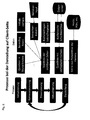
- FIG. 4 shows preferred processes in the acquisition and preprocessing of the data.
- the left column shows the individual processes, whereas the right column symbolizes a model representation.
- the process begins with the acquisition of data using an aircraft and / or satellite.
- SGM Semi-Global Matching
- the high-resolution surface models are generated. These correspond in the model to a digital surface model (DOM) on the one hand and digital orthophotography data (DOP) on the other hand.
- DOM digital surface model
- DOP digital orthophotography data
- LOD level-of-detail
- FIG. 5 Similarly, exemplary processes of both representations on the client side are shown.
- the quadtree the bounding boxes and the initial camera perspective.
- a user input controls the virtual viewer camera.
- the quadtree of the visible cells is created and corresponding tile requests are loaded and / or released.
- the tilecash provides the available tiles for the quadtree, possibly in cooperation with a data server, with the help of which the scene is then displayed from the perspective of the camera. Under certain circumstances tracks, points of interest (POI) etc. can be shown here.
- POI points of interest
- the traversal process of the quadtree for construction and presentation is in each of the FIGS. 6 and 7 shown.
- a specific node has been initialized. If this is not the case, the corresponding bounding box is loaded and then (or immediately) checked whether the corresponding node is visible. If not, this is marked as inactive, the child node is released and the traversal is ended. If the node is visible, it is checked if the resolution is too coarse. If not, the node is marked active, the corresponding tile data is requested, the child node is released, and traversal is terminated. If the resolution is too coarse, it is checked if there are children. If this is not the case, the node is again marked as active, the corresponding tile data is requested, the child node released and the traversing ended. If there are children, they are visited and the process starts again when the node is initialized.
- the traversal process of the quadtree for presentation also starts at the root and first asks if a particular branch is active. If not, the traversal is ended. If so, it checks if the node is inactive. If not, transforms and textures are enabled, geometry is drawn, and traversal stops. If the node is inactive, it checks whether all children are complete. If not, the transformations and textures are activated again, the geometry is drawn and the traversal is ended. If so, the whole process is repeated with the appropriate children
- the rendering of the surface models and image data is done in a hierarchical manner.
- the data are first tiled in the original resolution, ie, fragmented into preferably square components of fixed grid size (eg 64 x 64 pixels and / or height values).
- a so-called quadtree hierarchy is then built up via these basic tiles (cf. Fig. 1 ).
- each 2 x 2 adjacent tiles of the finer detail level form the basis for a tile on the next level of detail, until a detail level is reached, the only tile of which covers the entire data record. From level to level, the resolution or accuracy of the data is doubled.
- the cells or tiles contain no atomic information (color value / height value), but each represent a section of the data set (eg 64 x 64 color values).
- the initial triangle mesh is first formed on the finest level by a regular square mesh whose vertices interpolate the 2 x 2 adjacent height values. Instead of 128 x 128 height values you get then eg 129 x 129 network nodes.
- the lattice cells are subsequently triangulated. Preferably, the lattice is first triangulated in so-called "restricted quadtree manner" and approximated by means of nodule removal under Hausdorff distance metric.
- the triangle mesh of a cell is first formed from the four triangular meshes of the 2 x 2 tiles of finer resolution. This is then so closely approximated by edge-collapse operations that the Hausdorff distance to the initial triangle mesh does not exceed the precision measure of the detail level. When estimating the Hausdorffabstands additional Disturbing influences such as loss of accuracy due to quantization of the vertices are already taken into account.
- the representation of the data within a tile or cell is optimized for the respective level of detail.
- a triangular approximation with guaranteed quality is first calculated for the elevation model at the finest level of detail (cf. Fig. 3b ). It is ensured that the edge profiles at the edges of adjacent cells are identical. These triangular networks are then merged on the coarser levels of detail along their common edges to form a triangular mesh, which in turn is approximated more coarsely.
- each image tile is coded using a standard image compression method, which preferably satisfies one or more (preferably all) of the following requirements: good preservation of the image signal, good compression for transmission, cost-effective unpacking on the mobile terminal.
- the geometry tiles or cells contain triangular meshes that are topologically equivalent to a disk.
- the connectivity of these triangular networks is similar to Standard methods (cut-border method, edgebreaker method) preferably encoded on the screening history, because it can then be very efficiently rebuilt from the bitstream.
- the location of the vertices within the tile is preferably quantized so that the precision of the detail level can still be guaranteed. For this purpose, the rounding error that arises should be taken into account in advance in the calculation of the approximation.
- a so-called "bounding box” is preferably also calculated per tile or cell, ie a cuboid which comprises the entire triangular mesh of the tile (cf. Fig. 3a ).
- a hierarchy of bounding boxes is used to decide which tiles or cells are required in the respective camera perspective (camera point and camera viewing angle).
- the active quadtree is first determined for the representation of the scene from a camera perspective. Starting with the only cell of level 0 (cf. Fig. 1 ) the cells are cut on the basis of their boxes with the camera frustum and refined in a so-called top-down manner until the resolution allows an adequate representation. Because of the set of radiation only half the resolution is needed at twice the distance to the camera. These cells then form the active quadtree. The associated cell data are loaded and displayed. These cells or tiles are successively requested by a cache. The data in the cache is used to represent the terrain. It can be different Textures (eg, summer and winter, high-resolution and low-resolution) are blended.
- Fig. 3a For each quadtree cell, there is a bounding box that includes the geometry (cf. Fig. 3a ), the geometry in the form of a detailed triangle mesh (cf. Fig. 3b ) and the texture in the resolution corresponding to the quadtree stage.
- Fig. 3c shows the geometry textured with the corresponding aerial tile with a resolution of 2 m.
- Vector information on activities and / or events is preferably displayed from geodatabases in the 3D view.
- the "camera” ie the angle of view shown
- the viewing parameters can be controlled interactively via multi-touch gestures and / or via icons.
- Movement data may preferably be recorded, stored and read in again and other information may be transmitted via e.g. Picking be retrieved.
- Live information with position information is preferably streamed over the Internet and displayed in the 3D view.
- the method according to the invention is suitable and optimized for being performed on a mobile terminal.
- Mobile devices and smartphones in particular pose a challenge in many respects.
- smartphones are usually based on other graphics chips, thus have far lower graphics performance and less graphics memory and provide a slimmer graphics API (OpenGL for embedded systems ES ) available.
- OpenGL embedded systems
- the method according to the invention scales with the number of cells shown. Halving the accuracy, the process requires only a quarter of the performance.
- smartphones have much less RAM (about an order of magnitude compared to PC), eg iOS / Android about 100 MB.
- Virtual memory is also not automatically provided.
- the data actually required for the photorealistic representation are in the method according to the invention (display and display) accuracy-dependent) usually well below the limit of about 10-30 MB.
- the caches for quickly restoring previously used data are significantly reduced in size according to the invention. Progressively reloading the data makes it possible to temporarily see less-resolved data, but the real-time requirement is preserved.
- administrative data structures eg for the quadtrees, are not kept completely in the memory, but are loaded dynamically. Additional data such as the collision surfaces for the collision-free navigation are preferably not completely loaded but only partially and cached.
Landscapes
- Physics & Mathematics (AREA)
- Engineering & Computer Science (AREA)
- Geometry (AREA)
- Software Systems (AREA)
- Computer Graphics (AREA)
- General Physics & Mathematics (AREA)
- Theoretical Computer Science (AREA)
- Remote Sensing (AREA)
- Processing Or Creating Images (AREA)
Priority Applications (1)
| Application Number | Priority Date | Filing Date | Title |
|---|---|---|---|
| EP12199023.8A EP2747032A1 (fr) | 2012-12-21 | 2012-12-21 | Procédé de visualisation photoréaliste d'un ensemble de données tridimensionnelles de terrain en temps réel |
Applications Claiming Priority (1)
| Application Number | Priority Date | Filing Date | Title |
|---|---|---|---|
| EP12199023.8A EP2747032A1 (fr) | 2012-12-21 | 2012-12-21 | Procédé de visualisation photoréaliste d'un ensemble de données tridimensionnelles de terrain en temps réel |
Publications (1)
| Publication Number | Publication Date |
|---|---|
| EP2747032A1 true EP2747032A1 (fr) | 2014-06-25 |
Family
ID=47721893
Family Applications (1)
| Application Number | Title | Priority Date | Filing Date |
|---|---|---|---|
| EP12199023.8A Withdrawn EP2747032A1 (fr) | 2012-12-21 | 2012-12-21 | Procédé de visualisation photoréaliste d'un ensemble de données tridimensionnelles de terrain en temps réel |
Country Status (1)
| Country | Link |
|---|---|
| EP (1) | EP2747032A1 (fr) |
Cited By (9)
| Publication number | Priority date | Publication date | Assignee | Title |
|---|---|---|---|---|
| CN110058684A (zh) * | 2019-03-21 | 2019-07-26 | 海南诺亦腾海洋科技研究院有限公司 | 一种基于vr技术的地理信息交互方法、系统及存储介质 |
| CN111210514A (zh) * | 2019-10-31 | 2020-05-29 | 浙江中测新图地理信息技术有限公司 | 一种将照片批量融合到三维场景中的方法 |
| CN111460051A (zh) * | 2020-04-02 | 2020-07-28 | 哈尔滨工程大学 | 一种基于树形结构与逐层次节点删减的数据关联方法 |
| US20210110578A1 (en) * | 2019-10-10 | 2021-04-15 | Electronics And Telecommunications Research Institute | Method and apparatus for configuring spatial information |
| CN113506378A (zh) * | 2021-07-29 | 2021-10-15 | 和舆图(北京)科技有限公司 | 一种在mr设备上动态加载三维模型的方法 |
| CN114088063A (zh) * | 2021-10-19 | 2022-02-25 | 青海省交通工程技术服务中心 | 一种基于移动终端的桥墩局部冲刷地形测量方法 |
| CN114463505A (zh) * | 2022-02-15 | 2022-05-10 | 中国人民解放军战略支援部队航天工程大学士官学校 | 一种外层空间环境要素模型构建方法及系统 |
| CN114708414A (zh) * | 2022-04-19 | 2022-07-05 | 中铁二院工程集团有限责任公司 | 一种工程三维地形数据切割融合方法与系统 |
| DE102022119422A1 (de) | 2021-08-04 | 2023-02-09 | Ocean Maps GmbH | Verfahren zum Erzeugen einer hierarchischen Datenstruktur, hierarchische Datenstruktur sowie Verfahren zum Streamen von dreidimensionalen Objekten |
Citations (1)
| Publication number | Priority date | Publication date | Assignee | Title |
|---|---|---|---|---|
| EP1503347A2 (fr) * | 2003-08-01 | 2005-02-02 | Sony Corporation | Système, appareil et procédé d'affichage de carte et dispositif de traitement des données de carte |
-
2012
- 2012-12-21 EP EP12199023.8A patent/EP2747032A1/fr not_active Withdrawn
Patent Citations (1)
| Publication number | Priority date | Publication date | Assignee | Title |
|---|---|---|---|---|
| EP1503347A2 (fr) * | 2003-08-01 | 2005-02-02 | Sony Corporation | Système, appareil et procédé d'affichage de carte et dispositif de traitement des données de carte |
Non-Patent Citations (4)
| Title |
|---|
| AGRAWAL A ET AL: "Real-time photorealistic visualisation of large-scale multiresolution terrain models", DEFENCE SCIENCE JOURNAL DEFENCE SCI. INF. & DOC. CENTRE INDIA, vol. 57, no. 1, January 2007 (2007-01-01), pages 149 - 162, XP008162471, ISSN: 0011-748X * |
| COHEN D ET AL: "PHOTO-REALISTIC IMAGING OF DIGITAL TERRAINS", COMPUTER GRAPHICS FORUM, WILEY-BLACKWELL PUBLISHING LTD, GB, vol. 12, no. 3, 10 September 1993 (1993-09-10), pages C363 - C373, XP008033773, ISSN: 0167-7055, DOI: 10.1111/1467-8659.1230363 * |
| JIANG WEN ET AL: "Real-Time Rendering of Large Terrain on Mobile Device", PROCEEDINGS OF THE XXIST ISPRS CONGRESS, TECHNICAL COMMISSION V, WG V/4 VIRTUAL REALITY AND COMPUTER ANIMATION, JULY 3-11, 2008, BEIJING, CHINA, 3 July 2008 (2008-07-03), pages 693 - 698, XP055064171, Retrieved from the Internet <URL:http://www.isprs.org/proceedings/XXXVII/congress/5_pdf/122.pdf> [retrieved on 20130527] * |
| PAJAROLA R: "Overview of Quadtree-based Terrain Triangulation and Visualisation", UCI-ICS TECHNICAL REPORT, DEPARTMENT OF INFORMATION & COMPUTER SCIENCE, UNIVERSITY OF CALIFORNIA, IRVINE, no. 2-01, 1 January 2002 (2002-01-01), pages 1 - 16, XP002493844 * |
Cited By (17)
| Publication number | Priority date | Publication date | Assignee | Title |
|---|---|---|---|---|
| CN110058684B (zh) * | 2019-03-21 | 2022-07-01 | 海南诺亦腾海洋科技研究院有限公司 | 一种基于vr技术的地理信息交互方法、系统及存储介质 |
| CN110058684A (zh) * | 2019-03-21 | 2019-07-26 | 海南诺亦腾海洋科技研究院有限公司 | 一种基于vr技术的地理信息交互方法、系统及存储介质 |
| US20210110578A1 (en) * | 2019-10-10 | 2021-04-15 | Electronics And Telecommunications Research Institute | Method and apparatus for configuring spatial information |
| US11798199B2 (en) * | 2019-10-10 | 2023-10-24 | Electronics And Telecommunications Research Institute | Method and apparatus for configuring spatial information |
| CN111210514A (zh) * | 2019-10-31 | 2020-05-29 | 浙江中测新图地理信息技术有限公司 | 一种将照片批量融合到三维场景中的方法 |
| CN111210514B (zh) * | 2019-10-31 | 2023-04-18 | 浙江中测新图地理信息技术有限公司 | 一种将照片批量融合到三维场景中的方法 |
| CN111460051A (zh) * | 2020-04-02 | 2020-07-28 | 哈尔滨工程大学 | 一种基于树形结构与逐层次节点删减的数据关联方法 |
| CN113506378A (zh) * | 2021-07-29 | 2021-10-15 | 和舆图(北京)科技有限公司 | 一种在mr设备上动态加载三维模型的方法 |
| DE102022119422A1 (de) | 2021-08-04 | 2023-02-09 | Ocean Maps GmbH | Verfahren zum Erzeugen einer hierarchischen Datenstruktur, hierarchische Datenstruktur sowie Verfahren zum Streamen von dreidimensionalen Objekten |
| AT525294A1 (de) * | 2021-08-04 | 2023-02-15 | Ocean Maps GmbH | Verfahren zum Erzeugen einer hierarchischen Datenstruktur, hierarchische Datenstruktur sowie Verfahren zum Streamen von dreidimensionalen Objekten |
| US12243164B2 (en) | 2021-08-04 | 2025-03-04 | Ocean Maps GmbH | Method for generating a hierarchical data structure, hierarchical data structure, and method for streaming three-dimensional objects |
| CN114088063A (zh) * | 2021-10-19 | 2022-02-25 | 青海省交通工程技术服务中心 | 一种基于移动终端的桥墩局部冲刷地形测量方法 |
| CN114088063B (zh) * | 2021-10-19 | 2024-02-02 | 青海省交通工程技术服务中心 | 一种基于移动终端的桥墩局部冲刷地形测量方法 |
| CN114463505B (zh) * | 2022-02-15 | 2023-01-31 | 中国人民解放军战略支援部队航天工程大学士官学校 | 一种外层空间环境要素模型构建方法及系统 |
| CN114463505A (zh) * | 2022-02-15 | 2022-05-10 | 中国人民解放军战略支援部队航天工程大学士官学校 | 一种外层空间环境要素模型构建方法及系统 |
| CN114708414A (zh) * | 2022-04-19 | 2022-07-05 | 中铁二院工程集团有限责任公司 | 一种工程三维地形数据切割融合方法与系统 |
| CN114708414B (zh) * | 2022-04-19 | 2023-06-23 | 中铁二院工程集团有限责任公司 | 一种工程三维地形数据切割融合方法与系统 |
Similar Documents
| Publication | Publication Date | Title |
|---|---|---|
| EP2747032A1 (fr) | Procédé de visualisation photoréaliste d'un ensemble de données tridimensionnelles de terrain en temps réel | |
| DE202011110887U1 (de) | Wiedergeben und navigieren fotografischer Panoramen mit Tiefeninformationen in einem geographischen Informationssystem | |
| DE69907644T2 (de) | Echtzeit system zur dreidimensionalen realistischen virtuellen-bildanzeige | |
| DE202011110924U1 (de) | Geführte Navigation durch mit Geo-Tags versehene Panoramen | |
| EP2206089B1 (fr) | Procédé et dispositif de représentation d'un objet virtuel dans un environnement réel | |
| CN114637026A (zh) | 一种基于三维仿真技术实现输电线路在线监测与智能巡检的方法 | |
| DE202014010917U1 (de) | Glatte Zeichenebene für das Rendern von Vektordaten komplexer dreidimensionaler Objekte | |
| LU504675B1 (de) | Ein verfahren zur gewinnung von informationen über die erdrutschgefahr auf der grundlage von uav-bilddaten in hochgebirgstalgebieten | |
| DE202009019138U1 (de) | Architekturen zur Erstellung und Darstellung von zeitabhängigen Bildern | |
| EP2030173A1 (fr) | Procédé pour la génération d'un modèle informatique tridimensionnel d'une ville | |
| EP0780800A2 (fr) | Méthode et appareil pour la visualisation de données spaciales | |
| EP1631938B1 (fr) | Procede de production d'un modele topographique tridimensionnel | |
| DE202015009198U1 (de) | Auswahl der zeitlich verteilten Panoramabilder für die Anzeige | |
| DE202009019124U1 (de) | Bildinhalte zur einfacheren Navigation in Panorama-Bilddaten | |
| DE202014010927U1 (de) | Referenzpunktidentifizierung aus Punktwolken, die aus geografischen Bilddaten erstellt werden | |
| DE102021204765A1 (de) | Rendern von Augmented-Reality mit Verdeckung | |
| DE202012013439U1 (de) | Das Verwenden von Banding zur Optimierung der Kartenwiedergabe in einer dreidimensionalen Neigungsansicht | |
| DE102015120999A1 (de) | Verfahren zur Erzeugung und Darstellung einer computergenerierten, eine Realumgebung abbildenden Simulationsumgebung | |
| DE112016003134T5 (de) | Anzeigen von Objekten basierend auf einer Vielzahl von Modellen | |
| DE202016008004U1 (de) | Automatische Verbindung von Bildern unter Verwendung visueller Eigenschaftsquerverweise auf zugehörige Anwendungen | |
| DE202013012446U1 (de) | Strukturüberblendung für weichen Übergang zwischen unterschiedlichen Detaillierungsgraden in Grafikanwendungen | |
| EP2457219A2 (fr) | Procédé et dispositif servant à générer des représentations de propriétés anisotropes et programme informatique correspondant et support mémoire correspondant lisible par ordinateur | |
| EP2401723A1 (fr) | Procédé, système et produit-programme informatique pour la représentation tridimensionnelle de bâtiments sur un dispositif d'affichage graphique d'un dispositif de navigation | |
| DE112020000751T5 (de) | Simulierte perspektivische überkopfbilder mit entfernung von hindernissen | |
| DE102012213336A1 (de) | Verfahren und Vorrichtung zur Ergänzung einer digitalen Karte um Höhenangaben an vorbestimmten geografischen Positionen |
Legal Events
| Date | Code | Title | Description |
|---|---|---|---|
| PUAI | Public reference made under article 153(3) epc to a published international application that has entered the european phase |
Free format text: ORIGINAL CODE: 0009012 |
|
| 17P | Request for examination filed |
Effective date: 20121221 |
|
| AK | Designated contracting states |
Kind code of ref document: A1 Designated state(s): AL AT BE BG CH CY CZ DE DK EE ES FI FR GB GR HR HU IE IS IT LI LT LU LV MC MK MT NL NO PL PT RO RS SE SI SK SM TR |
|
| AX | Request for extension of the european patent |
Extension state: BA ME |
|
| R17P | Request for examination filed (corrected) |
Effective date: 20141128 |
|
| RBV | Designated contracting states (corrected) |
Designated state(s): AL AT BE BG CH CY CZ DE DK EE ES FI FR GB GR HR HU IE IS IT LI LT LU LV MC MK MT NL NO PL PT RO RS SE SI SK SM TR |
|
| 17Q | First examination report despatched |
Effective date: 20160711 |
|
| STAA | Information on the status of an ep patent application or granted ep patent |
Free format text: STATUS: EXAMINATION IS IN PROGRESS |
|
| APBK | Appeal reference recorded |
Free format text: ORIGINAL CODE: EPIDOSNREFNE |
|
| APBN | Date of receipt of notice of appeal recorded |
Free format text: ORIGINAL CODE: EPIDOSNNOA2E |
|
| APBR | Date of receipt of statement of grounds of appeal recorded |
Free format text: ORIGINAL CODE: EPIDOSNNOA3E |
|
| APAF | Appeal reference modified |
Free format text: ORIGINAL CODE: EPIDOSCREFNE |
|
| APBT | Appeal procedure closed |
Free format text: ORIGINAL CODE: EPIDOSNNOA9E |
|
| STAA | Information on the status of an ep patent application or granted ep patent |
Free format text: STATUS: THE APPLICATION IS DEEMED TO BE WITHDRAWN |
|
| 18D | Application deemed to be withdrawn |
Effective date: 20210701 |