EP2819086A1 - Method to generate scenarios of hydrocarbon reservoirs based on limited amount of information on a target hydrocarbon reservoir - Google Patents
Method to generate scenarios of hydrocarbon reservoirs based on limited amount of information on a target hydrocarbon reservoir Download PDFInfo
- Publication number
- EP2819086A1 EP2819086A1 EP13382254.4A EP13382254A EP2819086A1 EP 2819086 A1 EP2819086 A1 EP 2819086A1 EP 13382254 A EP13382254 A EP 13382254A EP 2819086 A1 EP2819086 A1 EP 2819086A1
- Authority
- EP
- European Patent Office
- Prior art keywords
- records
- max
- ref
- porosity
- facies
- Prior art date
- Legal status (The legal status is an assumption and is not a legal conclusion. Google has not performed a legal analysis and makes no representation as to the accuracy of the status listed.)
- Withdrawn
Links
Images


Classifications
-
- G—PHYSICS
- G06—COMPUTING OR CALCULATING; COUNTING
- G06Q—INFORMATION AND COMMUNICATION TECHNOLOGY [ICT] SPECIALLY ADAPTED FOR ADMINISTRATIVE, COMMERCIAL, FINANCIAL, MANAGERIAL OR SUPERVISORY PURPOSES; SYSTEMS OR METHODS SPECIALLY ADAPTED FOR ADMINISTRATIVE, COMMERCIAL, FINANCIAL, MANAGERIAL OR SUPERVISORY PURPOSES, NOT OTHERWISE PROVIDED FOR
- G06Q50/00—Information and communication technology [ICT] specially adapted for implementation of business processes of specific business sectors, e.g. utilities or tourism
- G06Q50/02—Agriculture; Fishing; Forestry; Mining
Definitions
- the present invention is related to generating scenarios of hydrocarbon reservoirs based on limited amount of information on a target hydrocarbon reservoir, and more particularly to automatically supplying missing parameters and an uncertainty associated with each supplied parameter allowing to valuating the target hydrocarbon reservoir.
- Determining whether investing in a new hydrocarbon reservoir candidate is a good business decision depends on the inherent value of the reservoir. Factors determining the inherent value of the reservoir include, for example, the total amount of material that is ultimately recoverable from each new hydrocarbon reservoir (production potential), market prices (oil and/or natural gas prices) and the cost of recovering that material, or capture difficulty. Until the material is actually recovered, however, that inherent value can only be estimated from different, primarily known, reservoir properties.
- one or more experts e.g., geologists and reservoir engineers identified and selected analogous reservoirs, based solely on experience and known or available investment candidate properties. Relevant information of such analogous reservoirs are stored in data bases having records with information on volumetric, facies and properties distribution, wherein all records not necessarily have all properties.
- the specialized literature shows continuously increased interest in analogues and its predictions.
- Sophisticated data mining and machine learning algorithms allow estimation of properties and such estimations also define the degree of uncertainty which can be reliably used within geostatistical workflows.
- Example can be found on the usage of reservoir analogous in the context of reservoir drive mechanism, recovery factor or reserve estimation and classification.
- the present invention solves the problems providing a method to generate scenarios of hydrocarbon reservoirs when only limited amount of information on a target is available. Ranking reservoirs with different level of associated uncertainty within the same framework becomes key to make robust and unbiased decisions.
- the method according to the present invention allows assessing not only the geological parameters not known a priory with their associated uncertainty but also the geological and structural uncertainty of the reservoir with an accurate propagation of the inherent uncertainty.
- geological information comes from well logs, cores analysis, seismic data, etc. and production data can also be used to mitigate the uncertainty however in absence of these the geological scenario becomes hard to predict.
- geological information comprises scalar values lacking of spatial distributions as a three-dimensional structure.
- the method according to present invention generates scenarios of hydrocarbon reservoirs having a three-dimensional structure even if departing from scalar values.
- the method to generate scenarios of hydrocarbon reservoirs compiles information on the target hydrocarbon reservoir.
- Such information provides a concept model for the whole domain of the scenario.
- This information comprises scalar properties and may also comprise uncertainty data such as minimum and maximum values of some scalar data.
- the method requires the proposal of an integer number n of facies.
- the method provides automatically the partial rate f i , and a normal distribution of the porosity having a mean value ⁇ i and the cutoff values ⁇ i min and ⁇ i max for a predetermined threshold such that the area of the tail of the normal distribution is deemed to be neglectible beyond such threshold.
- Such variables are provided by solving an optimization problem that distributes the normal distribution of each facies in such a way the concept model is reproduced.
- the concept model is characterized by the number of facies and ⁇ ref min , ⁇ ref max , and the ⁇ ref values of porosity of the target hydrocarbon reservoir.
- the method mainly uses the computed partial rate f i to populate a plurality of three-dimensional scenarios having a three-dimensional domain and the shape of the n facies by means of a multipoint statistical method, preferably and not limited to a Sequential Indicator Simulation.
- each facie with its partial rate f i and the normal distribution of the porosity defined by the mean value ⁇ i and the cutoff values ⁇ i min and ⁇ i max , further embodiments of the invention allow to populate the spatial distribution of the permeability, the saturation and the net-to-gross variables.
- the first step of the method according to an embodiment of the invention compiles information on the target hydrocarbon.
- This information may be interpreted by a skilled person who may provide the number n of facies from this collected information.
- the number of facies is preferably between 1 and 8.
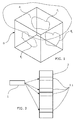
- Figure 1 shows a field having a domain (D) under certain portion of its surface, the area identified with letter A. This figure shows a domain (D) having three facies F 1 , F 2 F 3 distributed within the domain.
- the reservoir domain (D) In absence of any information from seismic or maps the reservoir domain (D) is considered as a hexahedral shape. Structural uncertainty is considered on both shape and volume. In the present case since the conceptual model is a regular shape the uncertainty is represented by the reservoir area and thickness and the width-over-length ratio.
- the number of facies and other properties may be obtained comparing the target information with the analog data base.
- the whole domain is modeled by a ⁇ ref min , ⁇ ref max , and ⁇ ref values which may be provided by a skilled person or the estimation may be obtained from the analogues data base, or more briefly "the analogues".
- has been implemented as the Euclidean norm.
- the objective function to be minimized represents the error between the estimated property as a function of facies type and the value provided for instance by the analogues.
- MILP Mixed Integer Linear Programming
- the reference values ⁇ ref min , ⁇ ref max , and ⁇ ref are obtained from the analogues data base (2).
- said information When compiling information on the target (1) hydrocarbon reservoir, said information at least have a material property among the material properties comprised in the records of the analog data base.
- the reference values are determined as follows:
- the plurality of three-dimensional scenarios having a three-dimensional domain is obtained generating the dimensions of said domain randomly. If the analogues has volumetric data such as the reservoir area and thickness, NTG (net-to-gross) and saturation information, then the maximum capacity to store oil within the domain is calculated. If the randomly generated domain (D) is not big enough to store the calculated volume of oil then said domain (D) is discarded.
- volumetric data such as the reservoir area and thickness, NTG (net-to-gross) and saturation information
- the OOIP Olinal oil in place
- V the volume of the domain
- ⁇ the mean value of the porosity
- NTG the mean value of the net-to-gross value
- S the saturation
- B the expansion factor of the oil when it is extracted from the reservoir and stored at ambient pressure.
- the porosity is spatially distributed based on its statistical distribution ⁇ i , ⁇ i min , ⁇ i max by means of geo-statistical algorithm providing a predetermined longitudinal correlation equation and a predetermined orientation.
- the spatial distribution of the porosity is defined in each scenario of the plurality of scenarios.
- the permeability property (K) is determined for each scenario.
- the records of the analogues data base (2) have to comprise the permeability property of the materials and the porosity. From the selected records the correlation between the permeability versus the porosity is calculated wherein most of the cases the law between both variables is expressed as the logarithmic value of the permeability versus the porosity according to the Carman-Kozeny law.
- the selected records are those selected when the reference values ⁇ ref min , ⁇ ref max , and ⁇ ref are obtained from the analogues data base (2).
- K C ⁇ ⁇ 3 1 - ⁇ 2 is used to fit the scatter from the relation between permeability (K) and porosity ( ⁇ ).
- the coefficient C can be estimated using a least square regression.
- the permeability variance has also been parametrized using a linear regression model as a function of porosity in order to correctly propagate the uncertainty in the three/dimensional realizations. To have a reliable simulation it is important to separate the effects of the mean (the trend) which is deterministic with porosity and the variance which is simulated by geo-statistical techniques.
- the correlation law provides the scalar distribution of the permeability as a function of the porosity.
- the permeability as a scalar field is defined over said three-dimensional domain.
- the geostatistical algorithm For each scenario generated when the porosity has been populated, the geostatistical algorithm generates a plurality of scenarios taking into account the variability of the permeability property.
- Figure 4 shows the initial scalar data, the first group of scenarios generated when populating the porosity property taking into account uncertainty; and, according to the last step, the plurality of scenarios departing from each former scenario wherein this second generation of scenarios provides the variability of the permeability taking into account how the uncertainty for said permeability property is propagated.
- the water saturation is calculated. To compute initial water saturation and later the net-to-gross, the results for analogous have been further exploit.
- the selected records those selected when the reference values ⁇ ref min , ⁇ ref max , and ⁇ ref are obtained from the analogues data base (2), also comprises the water saturation, or data on water saturation allowing to calculate the S for instance by means of correlations taking into account several properties different from the water saturation.
Landscapes
- Business, Economics & Management (AREA)
- Engineering & Computer Science (AREA)
- Human Resources & Organizations (AREA)
- Marketing (AREA)
- Marine Sciences & Fisheries (AREA)
- Mining & Mineral Resources (AREA)
- Agronomy & Crop Science (AREA)
- Health & Medical Sciences (AREA)
- Economics (AREA)
- General Health & Medical Sciences (AREA)
- Life Sciences & Earth Sciences (AREA)
- Animal Husbandry (AREA)
- Primary Health Care (AREA)
- Strategic Management (AREA)
- Tourism & Hospitality (AREA)
- Physics & Mathematics (AREA)
- General Business, Economics & Management (AREA)
- General Physics & Mathematics (AREA)
- Theoretical Computer Science (AREA)
- Complex Calculations (AREA)
Abstract
Description
- The present invention is related to generating scenarios of hydrocarbon reservoirs based on limited amount of information on a target hydrocarbon reservoir, and more particularly to automatically supplying missing parameters and an uncertainty associated with each supplied parameter allowing to valuating the target hydrocarbon reservoir.
- Determining whether investing in a new hydrocarbon reservoir candidate is a good business decision depends on the inherent value of the reservoir. Factors determining the inherent value of the reservoir include, for example, the total amount of material that is ultimately recoverable from each new hydrocarbon reservoir (production potential), market prices (oil and/or natural gas prices) and the cost of recovering that material, or capture difficulty. Until the material is actually recovered, however, that inherent value can only be estimated from different, primarily known, reservoir properties.
- However, investment opportunities frequently include a number of candidate reservoirs with spotty available information on each. Even with a dearth of available information, however, it is imperative to assess the value of each candidate accurately. This assessment may be even more complex when types of available information vary from candidate to candidate. Arriving at an optimal project portfolio value requires a uniform assessment that consistently evaluates all alternatives uniformly.
- Some investment candidate estimates have been based on identifying existing reservoirs with properties that match or closely match (i.e., are similar to) the new, candidate reservoir. The closest existing reservoirs are known as "analogous reservoirs."
- Typically, one or more experts (e.g., geologists and reservoir engineers) identified and selected analogous reservoirs, based solely on experience and known or available investment candidate properties. Relevant information of such analogous reservoirs are stored in data bases having records with information on volumetric, facies and properties distribution, wherein all records not necessarily have all properties.
- The specialized literature shows continuously increased interest in analogues and its predictions. Sophisticated data mining and machine learning algorithms allow estimation of properties and such estimations also define the degree of uncertainty which can be reliably used within geostatistical workflows. Example can be found on the usage of reservoir analogous in the context of reservoir drive mechanism, recovery factor or reserve estimation and classification.
- Insufficient information, however, can make selecting analogous reservoirs guesswork at best, and make estimating the value error prone and uncertain. A mis-valuation could lead to wasted resources, e.g., from passing on an undervalued reservoir to exploit an overvalued reservoir. Missing parameters increase uncertainty and the likelihood of a mis-valuation.
- Thus, there is a need for generating scenarios compatible with the limited amount of information available on a target hydrocarbon reservoir, while including an associated uncertainty for the assessment; and more particularly, for estimating geological and petrophysical properties.
- The present invention solves the problems providing a method to generate scenarios of hydrocarbon reservoirs when only limited amount of information on a target is available. Ranking reservoirs with different level of associated uncertainty within the same framework becomes key to make robust and unbiased decisions. The method according to the present invention allows assessing not only the geological parameters not known a priory with their associated uncertainty but also the geological and structural uncertainty of the reservoir with an accurate propagation of the inherent uncertainty.
- Normally, geological information comes from well logs, cores analysis, seismic data, etc. and production data can also be used to mitigate the uncertainty however in absence of these the geological scenario becomes hard to predict.
- In most of cases, geological information comprises scalar values lacking of spatial distributions as a three-dimensional structure. The method according to present invention generates scenarios of hydrocarbon reservoirs having a three-dimensional structure even if departing from scalar values.
- According to a first aspect of the invention, the method to generate scenarios of hydrocarbon reservoirs compiles information on the target hydrocarbon reservoir. Such information provides a concept model for the whole domain of the scenario. This information comprises scalar properties and may also comprise uncertainty data such as minimum and maximum values of some scalar data.
- The method requires the proposal of an integer number n of facies. For each facie, the method provides automatically the partial rate fi , and a normal distribution of the porosity having a mean value
φ i and the cutoff values


φ ref values of porosity of the target hydrocarbon reservoir. - The method mainly uses the computed partial rate fi to populate a plurality of three-dimensional scenarios having a three-dimensional domain and the shape of the n facies by means of a multipoint statistical method, preferably and not limited to a Sequential Indicator Simulation.
- Once the plurality of three-dimensional scenarios with the n facies are generated, each facie with its partial rate fi and the normal distribution of the porosity defined by the mean value
φ i and the cutoff values

- These and other features and advantages of the invention will be seen more clearly from the following detailed description of a preferred embodiment provided only by way of illustrative and non-limiting example in reference to the attached drawings.
- Figure 1
- This figure shows a domain having three facies located within the do-main.
- Figure 2
- This figure shows a schematic representation of an analogous data base wherein selected records have been selected when comparing the in-formation of the target according to a predefined criterion.
- Figure 3
- This figure shows the distribution of the porosity for the concept model and how the normal distribution for each facies is distributed reproducing the concept model by solving an optimization problem.
- Figure 4
- This figure shows the set of scenarios generated in each property calculation providing a first generation and a second generation of scenarios.
- The first step of the method according to an embodiment of the invention compiles information on the target hydrocarbon. This information may be interpreted by a skilled person who may provide the number n of facies from this collected information. The number of facies is preferably between 1 and 8.
Figure 1 shows a field having a domain (D) under certain portion of its surface, the area identified with letter A. This figure shows a domain (D) having three facies F 1, F 2 F 3 distributed within the domain. - In absence of any information from seismic or maps the reservoir domain (D) is considered as a hexahedral shape. Structural uncertainty is considered on both shape and volume. In the present case since the conceptual model is a regular shape the uncertainty is represented by the reservoir area and thickness and the width-over-length ratio.
- An interpolative function has been developed to estimate the joint distribution of reservoir area and thickness from the analogues data base whereas the width-over-length ratio parameter is assumed to be uniformly varying between its boundaries. Numerical analysis has shown that the reservoir area and thickness could be approximated with a lognormal bivariate distribution with a high confidence interval.
- It is important to underline that the joint probability of area and thickness its key in order to preserve the interval of confidence given from the analogues in terms of volumetric and reserves. If there is information about the total amount of the oil of the reservoir or such amount may be estimated then the domain must be chosen big enough to contain that amount of oil.
- According to an embodiment of the invention the number of facies and other properties may be obtained comparing the target information with the analog data base.
- Each facies Fi,i = 1..n, is modeled by its partial rate fi , and a normal distribution of the porosity having a mean value
φ i and the cutoff values


- As is shown in
figure 3 , the whole domain is modeled by a
φ ref values which may be provided by a skilled person or the estimation may be obtained from the analogues data base, or more briefly "the analogues". - Next step calculates


wherein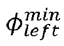


andφ i are taken such thatφ i <φ i+1 i = 1..n - 1. - In an embodiment, the norm ||·|| has been implemented as the Euclidean norm. The objective function to be minimized represents the error between the estimated property as a function of facies type and the value provided for instance by the analogues.
-
Figure 3 shows a four facies case (n = 4) wherein the four normal distributions of porosity are distributed according to the minimum of the cost function; and, the partial rate fi, i = 1,...,4 is simultaneously determined. - This minimization problem may be solved using Mixed Integer Linear Programming (MILP). The solution jointly computes the relative proportion of each facies and the conditional distribution of the properties per facies. This estimates will be consistent with the value of min, max and average used as the reference:

φ ref . - In an embodiment of the invention the reference values

φ ref are obtained from the analogues data base (2). When compiling information on the target (1) hydrocarbon reservoir, said information at least have a material property among the material properties comprised in the records of the analog data base. The reference values are determined as follows: - 1. When providing an analogues data base (2) comprising records of known reservoirs, at least one record further comprises the porosity of the material, that is, the minimum value

φ an of the porosity, and the maximum value
These three values allow assuming a property distribution shape such as a Normal distribution. The porosity will be used to compute the reference value as the mean value of a subset of records of the analogs data having such property. - 2. When compiling information on the target hydrocarbon reservoir in step a), such information has at least a material property among the material properties comprised in the records of the analog data base.
Common properties in the target hydrocarbon reservoir and in the analogs data base allows comparing the target (1) information and closely related analogues records (2.1). Common properties may be different to the porosity. - 3. Provide a similarity criterion for the comparison of reservoirs sharing at least a common material property.
The similarity criterion is the criteria to define which records of the analogues data base are close to the target (1). This criterion may even combine properties or correlation between two or more properties. - 4. Select the set of m records (2.1) in the analogues data base (2) meeting the similarity criterion with the target reservoir, wherein at least one record of the selected record comprises the porosity of the material,
- 5. Determining

φ ref values wherein said values are obtained for the set of records of the analog data base selected in step 4) as:-

-
φ ref = Mean(φ an,j )j = 1 ... m; and, -

-
- In an embodiment of the present invention, the plurality of three-dimensional scenarios having a three-dimensional domain is obtained generating the dimensions of said domain randomly. If the analogues has volumetric data such as the reservoir area and thickness, NTG (net-to-gross) and saturation information, then the maximum capacity to store oil within the domain is calculated. If the randomly generated domain (D) is not big enough to store the calculated volume of oil then said domain (D) is discarded.
- For example, the OOIP (Original oil in place) may be estimated as:

wherein V is the volume of the domain, φ is the mean value of the porosity, NTG is the mean value of the net-to-gross value, S is the saturation and, B is the expansion factor of the oil when it is extracted from the reservoir and stored at ambient pressure. - Once the facies has been generated and

φ i ,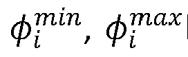
- After populating the porosity according to its statistical distribution, the longitudinal correlation equation and the orientation, the permeability property (K) is determined for each scenario.
- To carry out this further step, the records of the analogues data base (2) have to comprise the permeability property of the materials and the porosity. From the selected records the correlation between the permeability versus the porosity is calculated wherein most of the cases the law between both variables is expressed as the logarithmic value of the permeability versus the porosity according to the Carman-Kozeny law. The selected records are those selected when the reference values
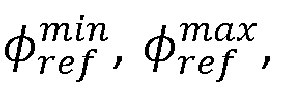
φ ref are obtained from the analogues data base (2). - According to the Carman-Kozeny law the equation

is used to fit the scatter from the relation between permeability (K) and porosity (φ). The coefficient C can be estimated using a least square regression. To allow low scatter in the distribution further filters on the analogues results can be applied such as exploit possible correlation with additional variables as could be depth. The permeability variance has also been parametrized using a linear regression model as a function of porosity in order to correctly propagate the uncertainty in the three/dimensional realizations. To have a reliable simulation it is important to separate the effects of the mean (the trend) which is deterministic with porosity and the variance which is simulated by geo-statistical techniques. - The correlation law provides the scalar distribution of the permeability as a function of the porosity. By means of a geo statistical algorithm, for each domain of the generated scenarios the permeability as a scalar field is defined over said three-dimensional domain. For each scenario generated when the porosity has been populated, the geostatistical algorithm generates a plurality of scenarios taking into account the variability of the permeability property.
Figure 4 shows the initial scalar data, the first group of scenarios generated when populating the porosity property taking into account uncertainty; and, according to the last step, the plurality of scenarios departing from each former scenario wherein this second generation of scenarios provides the variability of the permeability taking into account how the uncertainty for said permeability property is propagated. - Once the porosity and the permeability has been distributed in the second generation of scenarios, according to a further embodiment of the invention the water saturation is calculated. To compute initial water saturation and later the net-to-gross, the results for analogous have been further exploit.
- In this case, the selected records, those selected when the reference values


φ ref are obtained from the analogues data base (2), also comprises the water saturation, or data on water saturation allowing to calculate theS for instance by means of correlations taking into account several properties different from the water saturation. - For the m selected records, being m > n, using the mean porosity conditioned on facies computed in the optimization algorithm together with the mean per each analogues j we can express the following over determined system of m equations:
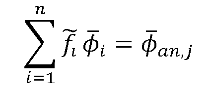
is solved preferably by least square method. The equation
- Analogously the system of equations

and
are specify for water saturation and net-to-gross calculation. In this case, the facies proportion per analogue, f̃l i = 1,...,n is known from the former system and the mean of the water saturation for each facies and the mean of the net-to-gross also for each facies is obtained by solving the over determined system, for instance, by least square method.
Claims (10)
- Method to generate scenarios of hydrocarbon reservoirs based on limited amount of information on a target hydrocarbon reservoir, comprising the steps:a. compile information on the target hydrocarbon reservoir,b. providing an integer number n of facies, preferably between 1 and 8, comprised in the domain of the scenario modeling the target hydrocarbon reservoir, wherein each facies Fi,i = 1..n, is modeled by its partial rate fi , and a normal distribution of the porosity having a mean value
φ i and the cutoff values
 -
-φ i <φ i+1 i = 1..n - 1- -
- c. determining
φ ref values,d. determining

wherein


 e. generating a plurality of three-dimensional scenarios having a three-dimensional domain and the shape of the n facies by means of a multipoint statistical method, preferably a Sequential Indicator Simulation, wherein multipoint statistical method is restricted to the number of facies n, the partial rates of facies fi , i = 1..n.
 - Method according to claim 1 wherein it further comprises providing an analog data base comprising records of known reservoirs wherein each record comprises scalar data of material properties for determining values such as facies properties.
- Method according to claim 1 and 2 wherein the

φ ref values are obtained as follows:1. when providing an analog data base comprising records of known reservoirs, at least one record further comprises the porosity of the material, that is, the minimum value
φ an of the porosity, and the maximum value 2. when compiling information on the target hydrocarbon reservoir in step a), such information has at least a material property among the material properties comprised in the records of the analog data base,3. provide a similarity criterion for the comparison of reservoirs sharing at least a common material property,4. select the set of m records in the analog data base meeting the similarity criterion with the target reservoir, wherein at least one record of the selected record comprises the porosity of the material,5. when determining
φ ref values in step c), such values are obtained for the set of records of the analog data base selected in step 4) as:- -
-φ ref = Mean(φ an,j )j = 1...m; and,-
- Method according to claim 1 and 2, and any of previous claims wherein:- the records of the analog data base further comprises volumetric data such as the reservoir area and thickness, NTG (net-to-gross) and saturation information,- when generating a plurality of three-dimensional scenarios on step e) having a three-dimensional domain, the domain is generated randomly from a multidimensional correlation between area and thickness and has a volume verifying that is big enough to store the oil calculated according to the volumetric data.
- Method according to any of previous claims wherein the multipoint statistical method for generating the plurality of three-dimensional scenarios is restricted in each scenario to the number of facies n, the partial rates of facies fi ,i = 1..n, and the property φ is spatially distributed based on its statistical distribution
φ j ,
- Method according to any previous claim and in particular claim 2, wherein a plurality of records of the analog data base further comprises the permeability (K) property of the materials and the porosity,- determining a correlation between the permeability versus the porosity, preferably the Carman-Kozeny law expressed as the logarithmic value of the permeability versus the porosity, obtained from the set of analog data base records selected in step 4) in claim 3,- the dispersion of the former law is obtained from the same set of analog data base records selected in step 4) in claim 3,- the permeability as a scalar field defined over the three-dimensional domain for each three-dimensional scenario is generated based on the correlation between permeability and porosity and its variability by means of geo-statistical algorithm.
- Method according claim 1, 2 and 3; and to any previous claim wherein the m selected records on step 4 of claim 3 of the analog data base further comprises the water saturation values of the materials
S , or, data on water saturation allowing to calculate theS , form such data by postprocessing and the average water saturation for each facies is calculated as follows:- for the m selected records, being m > n, solving the over determined system of m equations, preferably by mean square method:
for all j = 1,...,m records of the analogues data base and the n unknowns= 1, ...,n;
beingφ i the mean porosity for each facie Fi,i = 1.. n calculated on step e); and,φ an,j j = 1, ...,m the mean values of the m selected records obtained from the analogues data base,- for each facies Fi,i = 1..n, the average value of the saturationS i is calculated by solving the over determined system of equations, preferably the by least square method:
- Method according claim 1, 2 and 3; and to any previous claim wherein the m selected records on step 4 of claim 3 of the analog data base further comprises the net-to-gross NTG values of the materials
NTG ,; or, data on net-to-gross NTG allowing to calculate theNTG , form such data by postprocessing and the average NTG for each facies is calculated as follows:- for the m selected records, being m > n, solving the over determined system of m equations, preferably by mean square method:
for all j = 1,...,m records of the analogues data base and the n unknowns= 1, ...,n;
beingφ i the mean porosity for each facie Fi , i = 1.. n calculated on step e); and,φ an,j 7 = 1, ...,m the mean values of the m selected records obtained from the analogues data base,- for each facies Fi,i = 1..n, the average value of the net-to-grossNTG i is calculated by solving the over determined system of equations, preferably the by least square method:
- A data processing system comprising means for carrying out a method according to any of claims 1 to 8.
- A computer program product adapted to perform a method according to any of claims 1 to 8.
Priority Applications (7)
| Application Number | Priority Date | Filing Date | Title |
|---|---|---|---|
| EP13382254.4A EP2819086A1 (en) | 2013-06-28 | 2013-06-28 | Method to generate scenarios of hydrocarbon reservoirs based on limited amount of information on a target hydrocarbon reservoir |
| US14/220,397 US9458713B2 (en) | 2012-11-14 | 2014-03-20 | Generating hydrocarbon reservoir scenarios from limited target hydrocarbon reservoir information |
| PCT/EP2014/063689 WO2014207197A1 (en) | 2013-06-28 | 2014-06-27 | Method to generate scenarios of hydrocarbon reservoirs based on limited amount of information on a target hydrocarbon reservoir |
| CN201480036798.3A CN105453125A (en) | 2013-06-28 | 2014-06-27 | Method to generate scenarios of hydrocarbon reservoirs based on limited amount of information on a target hydrocarbon reservoir |
| BR112015032537A BR112015032537A2 (en) | 2013-06-28 | 2014-06-27 | method for generating hydrocarbon reservoir scenarios based on limited information in a target hydrocarbon reservoir |
| EP14733639.0A EP3014560A1 (en) | 2013-06-28 | 2014-06-27 | Method to generate scenarios of hydrocarbon reservoirs based on limited amount of information on a target hydrocarbon reservoir |
| CA2914465A CA2914465A1 (en) | 2013-06-28 | 2014-06-27 | Method to generate scenarios of hydrocarbon reservoirs based on limited amount of information on a target hydrocarbon reservoir |
Applications Claiming Priority (1)
| Application Number | Priority Date | Filing Date | Title |
|---|---|---|---|
| EP13382254.4A EP2819086A1 (en) | 2013-06-28 | 2013-06-28 | Method to generate scenarios of hydrocarbon reservoirs based on limited amount of information on a target hydrocarbon reservoir |
Publications (1)
| Publication Number | Publication Date |
|---|---|
| EP2819086A1 true EP2819086A1 (en) | 2014-12-31 |
Family
ID=48745877
Family Applications (1)
| Application Number | Title | Priority Date | Filing Date |
|---|---|---|---|
| EP13382254.4A Withdrawn EP2819086A1 (en) | 2012-11-14 | 2013-06-28 | Method to generate scenarios of hydrocarbon reservoirs based on limited amount of information on a target hydrocarbon reservoir |
Country Status (1)
| Country | Link |
|---|---|
| EP (1) | EP2819086A1 (en) |
Cited By (2)
| Publication number | Priority date | Publication date | Assignee | Title |
|---|---|---|---|---|
| CN110880048A (en) * | 2019-11-06 | 2020-03-13 | 国网湖北省电力有限公司宜昌供电公司 | Cascade reservoir ecological random optimization scheduling model and solving method |
| US11762888B2 (en) | 2020-12-16 | 2023-09-19 | Landmark Graphics Corporation | Geological database management using signatures for hydrocarbon exploration |
Citations (2)
| Publication number | Priority date | Publication date | Assignee | Title |
|---|---|---|---|---|
| WO2009145960A1 (en) * | 2008-04-17 | 2009-12-03 | Exxonmobil Upstream Research Company | Robust optimization-based decision support tool for reservoir development planning |
| US20110118983A1 (en) * | 2009-11-19 | 2011-05-19 | Chevron U.S.A. Inc. | System and method for reservoir analysis background |
-
2013
- 2013-06-28 EP EP13382254.4A patent/EP2819086A1/en not_active Withdrawn
Patent Citations (2)
| Publication number | Priority date | Publication date | Assignee | Title |
|---|---|---|---|---|
| WO2009145960A1 (en) * | 2008-04-17 | 2009-12-03 | Exxonmobil Upstream Research Company | Robust optimization-based decision support tool for reservoir development planning |
| US20110118983A1 (en) * | 2009-11-19 | 2011-05-19 | Chevron U.S.A. Inc. | System and method for reservoir analysis background |
Non-Patent Citations (1)
| Title |
|---|
| JEF CAERS ET AL: "Multiple-point geostatistics: a quantitative vehicle for integrating geologic analogs into multiple reservoir models", 2 January 2002 (2002-01-02), XP055085091, Retrieved from the Internet <URL:http://citeseerx.ist.psu.edu/viewdoc/download?rep=rep1&type=pdf&doi=10.1.1.218.1571> [retrieved on 20131023] * |
Cited By (3)
| Publication number | Priority date | Publication date | Assignee | Title |
|---|---|---|---|---|
| CN110880048A (en) * | 2019-11-06 | 2020-03-13 | 国网湖北省电力有限公司宜昌供电公司 | Cascade reservoir ecological random optimization scheduling model and solving method |
| CN110880048B (en) * | 2019-11-06 | 2022-06-21 | 国网湖北省电力有限公司宜昌供电公司 | Cascade reservoir ecological random optimization scheduling model and solving method |
| US11762888B2 (en) | 2020-12-16 | 2023-09-19 | Landmark Graphics Corporation | Geological database management using signatures for hydrocarbon exploration |
Similar Documents
| Publication | Publication Date | Title |
|---|---|---|
| EP3688498B1 (en) | Systems and methods for estimating a likelihood of reservoir productivity as a function of position in a subsurface volume of interest | |
| US9458713B2 (en) | Generating hydrocarbon reservoir scenarios from limited target hydrocarbon reservoir information | |
| US8954303B2 (en) | System and method for generating a geostatistical model of a geological volume of interest that is constrained by a process-based model of the geological volume of interest | |
| US10578767B2 (en) | Conditional process-aided multiple-points statistics modeling | |
| US8355872B2 (en) | System and method for reservoir analysis background | |
| US11282269B2 (en) | Image-comparison based analysis of subsurface representations | |
| EP3776270B1 (en) | Systems and methods for using probabilities of lithologies in an inversion | |
| US11733414B2 (en) | Systems and methods for generating subsurface data as a function of position and time in a subsurface volume of interest | |
| US12481079B2 (en) | Systems and methods for generating elastic property data as a function of position and time in a subsurface volume of interest | |
| US12092783B2 (en) | Systems and methods for generating subsurface property data as a function of position and time in a subsurface volume of interest | |
| EP4127784B1 (en) | Comparison of wells using a dissimilarity matrix | |
| US12494033B2 (en) | Systems and methods for analyzing clusters of type curve regions as a function of position in a subsurface volume of interest | |
| Goovaerts | Geostatistical modeling of the spaces of local, spatial, and response uncertainty for continuous petrophysical properties | |
| EP3014560A1 (en) | Method to generate scenarios of hydrocarbon reservoirs based on limited amount of information on a target hydrocarbon reservoir | |
| US20220035070A1 (en) | Determination of representative wells to characterize subsurface regions | |
| Larrondo et al. | Grade estimation in multiple rock types using a linear model of coregionalization for soft boundaries | |
| Borgos et al. | Shale reservoir characterization using 3D Markov field classification | |
| Deutsch | The place of geostatistical simulation in resource/reserve estimation | |
| Disiyona et al. | Uncertainty Analysis Workflow to Estimate Oil and Gas Reserves as A Guideline for Field Development Planning | |
| US20230042577A1 (en) | Systems and methods for generating depth uncertainty values as a function of position in a subsurface volume of interest | |
| Ortiz et al. | A multiGaussian approach to assess block grade uncertainty | |
| Disiyona | Uncertainty Analysis Workflow to Estimate Oil and Gas Reserves as A Guideline for Field | |
| Al-Kinani | Automation of Brownfield Development Workflows | |
| Machuca-Mory et al. | Tonnage Uncertainty Assessment of Vein-Type Deposits Using Distance Functions and Location-Dependent Correlograms |
Legal Events
| Date | Code | Title | Description |
|---|---|---|---|
| PUAI | Public reference made under article 153(3) epc to a published international application that has entered the european phase |
Free format text: ORIGINAL CODE: 0009012 |
|
| 17P | Request for examination filed |
Effective date: 20130628 |
|
| AK | Designated contracting states |
Kind code of ref document: A1 Designated state(s): AL AT BE BG CH CY CZ DE DK EE ES FI FR GB GR HR HU IE IS IT LI LT LU LV MC MK MT NL NO PL PT RO RS SE SI SK SM TR |
|
| AX | Request for extension of the european patent |
Extension state: BA ME |
|
| RBV | Designated contracting states (corrected) |
Designated state(s): AL AT BE BG CH CY CZ DE DK EE ES FI FR GB GR HR HU IE IS IT LI LT LU LV MC MK MT NL NO PL PT RO RS SE SI SK SM TR |
|
| R17P | Request for examination filed (corrected) |
Effective date: 20150626 |
|
| 17Q | First examination report despatched |
Effective date: 20160715 |
|
| STAA | Information on the status of an ep patent application or granted ep patent |
Free format text: STATUS: THE APPLICATION IS DEEMED TO BE WITHDRAWN |
|
| 18D | Application deemed to be withdrawn |
Effective date: 20161126 |