EP2851889A2 - System und Verfahren zum Verarbeiten und Anzeigen von Wirbelschleppen - Google Patents
System und Verfahren zum Verarbeiten und Anzeigen von Wirbelschleppen Download PDFInfo
- Publication number
- EP2851889A2 EP2851889A2 EP14183943.1A EP14183943A EP2851889A2 EP 2851889 A2 EP2851889 A2 EP 2851889A2 EP 14183943 A EP14183943 A EP 14183943A EP 2851889 A2 EP2851889 A2 EP 2851889A2
- Authority
- EP
- European Patent Office
- Prior art keywords
- aircraft
- ownship
- determining
- turbulence
- wake turbulence
- Prior art date
- Legal status (The legal status is an assumption and is not a legal conclusion. Google has not performed a legal analysis and makes no representation as to the accuracy of the status listed.)
- Granted
Links
- 238000000034 method Methods 0.000 title claims abstract description 40
- 238000012545 processing Methods 0.000 title description 8
- 239000003086 colorant Substances 0.000 claims description 2
- 230000008901 benefit Effects 0.000 description 6
- 238000004891 communication Methods 0.000 description 6
- 230000006870 function Effects 0.000 description 6
- 230000008569 process Effects 0.000 description 6
- 238000005516 engineering process Methods 0.000 description 5
- 230000004044 response Effects 0.000 description 5
- 230000001133 acceleration Effects 0.000 description 4
- 230000009471 action Effects 0.000 description 3
- 238000013459 approach Methods 0.000 description 2
- 238000010586 diagram Methods 0.000 description 2
- 230000007613 environmental effect Effects 0.000 description 2
- 230000002459 sustained effect Effects 0.000 description 2
- 230000015556 catabolic process Effects 0.000 description 1
- 238000007796 conventional method Methods 0.000 description 1
- 230000008878 coupling Effects 0.000 description 1
- 238000010168 coupling process Methods 0.000 description 1
- 238000005859 coupling reaction Methods 0.000 description 1
- 230000007423 decrease Effects 0.000 description 1
- 238000006731 degradation reaction Methods 0.000 description 1
- 230000001419 dependent effect Effects 0.000 description 1
- 238000013461 design Methods 0.000 description 1
- 238000009434 installation Methods 0.000 description 1
- 239000004973 liquid crystal related substance Substances 0.000 description 1
- 238000007726 management method Methods 0.000 description 1
- 238000013507 mapping Methods 0.000 description 1
- 230000008520 organization Effects 0.000 description 1
- 238000009877 rendering Methods 0.000 description 1
- 230000002441 reversible effect Effects 0.000 description 1
- 239000007787 solid Substances 0.000 description 1
- 230000002123 temporal effect Effects 0.000 description 1
- 239000010409 thin film Substances 0.000 description 1
- 230000000007 visual effect Effects 0.000 description 1
Images



Classifications
-
- B—PERFORMING OPERATIONS; TRANSPORTING
- B64—AIRCRAFT; AVIATION; COSMONAUTICS
- B64D—EQUIPMENT FOR FITTING IN OR TO AIRCRAFT; FLIGHT SUITS; PARACHUTES; ARRANGEMENT OR MOUNTING OF POWER PLANTS OR PROPULSION TRANSMISSIONS IN AIRCRAFT
- B64D45/00—Aircraft indicators or protectors not otherwise provided for
-
- B—PERFORMING OPERATIONS; TRANSPORTING
- B64—AIRCRAFT; AVIATION; COSMONAUTICS
- B64D—EQUIPMENT FOR FITTING IN OR TO AIRCRAFT; FLIGHT SUITS; PARACHUTES; ARRANGEMENT OR MOUNTING OF POWER PLANTS OR PROPULSION TRANSMISSIONS IN AIRCRAFT
- B64D43/00—Arrangements or adaptations of instruments
-
- G—PHYSICS
- G01—MEASURING; TESTING
- G01C—MEASURING DISTANCES, LEVELS OR BEARINGS; SURVEYING; NAVIGATION; GYROSCOPIC INSTRUMENTS; PHOTOGRAMMETRY OR VIDEOGRAMMETRY
- G01C23/00—Combined instruments indicating more than one navigational value, e.g. for aircraft; Combined measuring devices for measuring two or more variables of movement, e.g. distance, speed or acceleration
- G01C23/005—Flight directors
-
- G—PHYSICS
- G01—MEASURING; TESTING
- G01S—RADIO DIRECTION-FINDING; RADIO NAVIGATION; DETERMINING DISTANCE OR VELOCITY BY USE OF RADIO WAVES; LOCATING OR PRESENCE-DETECTING BY USE OF THE REFLECTION OR RERADIATION OF RADIO WAVES; ANALOGOUS ARRANGEMENTS USING OTHER WAVES
- G01S13/00—Systems using the reflection or reradiation of radio waves, e.g. radar systems; Analogous systems using reflection or reradiation of waves whose nature or wavelength is irrelevant or unspecified
- G01S13/88—Radar or analogous systems specially adapted for specific applications
- G01S13/95—Radar or analogous systems specially adapted for specific applications for meteorological use
- G01S13/953—Radar or analogous systems specially adapted for specific applications for meteorological use mounted on aircraft
-
- G—PHYSICS
- G01—MEASURING; TESTING
- G01W—METEOROLOGY
- G01W1/00—Meteorology
- G01W1/08—Adaptations of balloons, missiles, or aircraft for meteorological purposes; Radiosondes
-
- G—PHYSICS
- G01—MEASURING; TESTING
- G01W—METEOROLOGY
- G01W1/00—Meteorology
- G01W1/10—Devices for predicting weather conditions
-
- G—PHYSICS
- G05—CONTROLLING; REGULATING
- G05D—SYSTEMS FOR CONTROLLING OR REGULATING NON-ELECTRIC VARIABLES
- G05D1/00—Control of position, course, altitude or attitude of land, water, air or space vehicles, e.g. using automatic pilots
- G05D1/04—Control of altitude or depth
- G05D1/042—Control of altitude or depth specially adapted for aircraft
- G05D1/046—Control of altitude or depth specially adapted for aircraft to counteract a perturbation, e.g. gust of wind
-
- G—PHYSICS
- G08—SIGNALLING
- G08G—TRAFFIC CONTROL SYSTEMS
- G08G5/00—Traffic control systems for aircraft
- G08G5/20—Arrangements for acquiring, generating, sharing or displaying traffic information
- G08G5/21—Arrangements for acquiring, generating, sharing or displaying traffic information located onboard the aircraft
-
- G—PHYSICS
- G08—SIGNALLING
- G08G—TRAFFIC CONTROL SYSTEMS
- G08G5/00—Traffic control systems for aircraft
- G08G5/20—Arrangements for acquiring, generating, sharing or displaying traffic information
- G08G5/25—Transmission of traffic-related information between aircraft
-
- G—PHYSICS
- G08—SIGNALLING
- G08G—TRAFFIC CONTROL SYSTEMS
- G08G5/00—Traffic control systems for aircraft
- G08G5/70—Arrangements for monitoring traffic-related situations or conditions
- G08G5/72—Arrangements for monitoring traffic-related situations or conditions for monitoring traffic
- G08G5/723—Arrangements for monitoring traffic-related situations or conditions for monitoring traffic from the aircraft
-
- G—PHYSICS
- G08—SIGNALLING
- G08G—TRAFFIC CONTROL SYSTEMS
- G08G5/00—Traffic control systems for aircraft
- G08G5/70—Arrangements for monitoring traffic-related situations or conditions
- G08G5/76—Arrangements for monitoring traffic-related situations or conditions for monitoring atmospheric conditions
-
- G—PHYSICS
- G01—MEASURING; TESTING
- G01W—METEOROLOGY
- G01W1/00—Meteorology
- G01W2001/003—Clear air turbulence detection or forecasting, e.g. for aircrafts
Definitions
- the exemplary embodiments described herein generally relate to aircraft wake turbulence and more particularly to processing and displaying wake turbulence to a pilot of an aircraft.
- Cockpit Display of Traffic Information (CDTI) displays can show surrounding traffic with increased accuracy and provide improved situation awareness.
- aircraft transponders receive global positioning system (GPS) signals and determine the aircraft's precise position. This position is combined with other data and broadcast out to other aircraft and air traffic controllers.
- GPS global positioning system
- This display of surrounding traffic increases the pilot's awareness of traffic over and above that provided by Air Traffic Control (ATC).
- ATC Air Traffic Control
- a system and method are provided for processing and displaying wake turbulence to a pilot of an aircraft.
- a system for displaying a wake turbulence of an aircraft with respect to an ownship comprises a plurality of data sources configured to determine a location, flight parameters, and a type of the aircraft; and a location, flight parameters, and a type of the ownship; a processor coupled to the plurality of data sources and configured to determine an envelope relating to a flight path of the ownship; a wake turbulence within the envelope of the aircraft in consideration of the location, flight parameters, and the type of the aircraft; periodically a decay rate of the wake turbulence; periodically a severity of the wake turbulence with respect to the decay rate; and a format indicating the severity; and a display coupled to the processor and configured to display the format of the wake turbulence.
- a system for displaying a wake turbulence of an aircraft with respect to an ownship comprises a plurality of data sources configured to determine a location, flight parameters, and a type of the aircraft; and a location, flight parameters, and a type of the ownship; a processor coupled to the plurality of data sources and configured to determine an envelope relating to a flight path of the ownship; a wake turbulence within the envelope of the aircraft in consideration of the location, flight parameters, and the type of the aircraft and the location and type of the ownship; a symbol for the wake turbulence, the symbol including a plurality of parallel lines formed perpendicular to the flight path of the aircraft; a severity of the wake turbulence of each of the lines of the symbol; and a decay rate for the severity of each of the lines of the symbol; and a display coupled to the processor and configured to display the symbol of the wake turbulence.
- a method for displaying a wake turbulence of an aircraft with respect to an ownship comprises determining a location, flight parameters, and a type of the aircraft; determining a location, flight parameters, and a type of the ownship; determining an envelope of concern relating to a flight path of the ownship; determining a wake turbulence within the envelope of the aircraft in consideration of the location, flight parameters, and the type of the aircraft; periodically determining a decay rate of the wake turbulence; periodically determining a severity of the wake turbulence with respect to the decay rate; determining a format indicating the severity; and displaying the format of the wake turbulence.
- the exemplary embodiments described herein refer to displaying the information on aircraft, the invention may also be applied to other vehicle display systems such as displays in sea going vessels and displays used by off-site controllers, e.g., ATC and ground controllers for drones.
- off-site controllers e.g., ATC and ground controllers for drones.
- Skilled artisans may implement the described functionality in varying ways for each particular application, but such implementation decisions should not be interpreted as causing a departure from the scope of the present invention.
- an embodiment of a system or a component may employ various integrated circuit components, e.g., memory elements, digital signal processing elements, logic elements, look-up tables, or the like, which may carry out a variety of functions under the control of one or more microprocessors or other control devices.
- integrated circuit components e.g., memory elements, digital signal processing elements, logic elements, look-up tables, or the like, which may carry out a variety of functions under the control of one or more microprocessors or other control devices.
- a software module may reside in RAM memory, flash memory, ROM memory, EPROM memory, EEPROM memory, registers, hard disk, a removable disk, a CD-ROM, or any other form of storage medium known in the art.
- An exemplary storage medium is coupled to the processor such the processor can read information from, and write information to, the storage medium.
- the storage medium may be integral to the processor.
- the processor and the storage medium may reside in an ASIC.
- the ASIC may reside in a user terminal.
- Coupled means that one element/node/feature is directly or indirectly joined to (or directly or indirectly communicates with) another element/node/feature, and not necessarily mechanically.
- drawings may depict one exemplary arrangement of elements, additional intervening elements, devices, features, or components may be present in an embodiment of the depicted subject matter.
- certain terminology may also be used in the following description for the purpose of reference only, and thus are not intended to be limiting.
- mapping methods described herein may be used with a variety of aircraft, such as planes and helicopters.
- the aviation environment is described herein as the exemplary embodiment and may include navigation from point to point or approach and landing at an airport.
- Various types of maps may be used for display on the lateral view, for example, road maps, terrain maps, aviation maps, and topographical maps.
- Some applications may require more than one monitor, for example, a head down display screen, to accomplish the mission.
- These monitors may include a two dimensional moving map display.
- a moving map display may include a top-down view of the aircraft, the flight plan, and the surrounding environment.
- Various symbols are utilized to denote navigational cues, e.g., waypoint symbols, line segments interconnecting the waypoint symbols, range rings, and nearby environmental features, e.g., terrain, weather conditions, and political boundaries.
- Alternate embodiments of the present invention to those described below may utilize whatever navigation system signals are available, for example a ground based navigational system, a global positioning system (GPS) navigation aid, a flight management system, and an inertial navigation system.
- GPS global positioning system
- the location, including latitude/longitude and altitude, of the displayed first symbol of an ownship may be determined, for example, from a GPS, and for other aircraft from an ADS-B.
- ADS-B enhances safety by making an aircraft visible, real time, to ATC and to other appropriately equipped ADS-B aircraft with position and velocity data transmitted every second.
- the system relies on two avionics components: a high-integrity navigation source and a datalink for ADS-B.
- Wake turbulence severity depends on other traffic type, ownship type, winds, atmospheric turbulence, speed, and relative positions in three dimensional space.
- By tracking each segment of wake independently it is possible to "age" the wake using ownship data and display the wake segment as individual lines that are colorized for the relative severity of the wakes. For example, a red line would be severe, yellow moderate, and green light. These are not based on time alone, but on a decay factor as will be described hereinafter.
- An array stores the wake segments. Each wake segment will, at a minimum, contain the current location (latitude, longitude, and altitude), orientation (heading of traffic at time of generation), target altitude (drift down is a function of the generation altitude), and current severity index.
- the ownship system defines coefficients for the levels of severity.
- Each level of severity e.g., severe, moderate, light, would be defined by, for example, a different color and/or line weights and styles.
- Wake turbulence severity depends on ownship type; traffic type, speed, and relative positions in three dimensional space; and environmental factors including winds and atmospheric turbulence.
- a wake segment is sampled for all relevant aircraft. Relevancy is based on distance from ownship both in lateral and vertical directions.
- all tracked segments of wake turbulence are "aged". This includes adjustments for wind speed and direction (can be determined from winds around the ownship or the other aircraft) and decay in severity.
- the decay factor is a function of sensed turbulence at the ownship. For example, the decay factor could vary from 0.9 (calm) to 0.2 (turbulent). This effectively decreases the severity every time interval. If a segment's severity drops below the lowest limit, it would be dropped from the tracking file.
- Wake segments are displayed when within an envelope determined by their location relative to the ownship path and altitude.
- the envelope would comprise relative altitude (+3000/-1000) and a distance (+/- 90 degrees of current track within 40nm), or within 1 nm. Segments that are in the envelope are then drawn in reverse severity order to ensure that overlapping segments have the severe (red) are on top of any moderate (yellow), which in turn are on top of any light (green).
- Sensing turbulence would involve using high pass filters, preferably on all three axes of acceleration.
- the resultant acceleration rate would be filtered to observe a longer term turbulence which would be indicative of the whole air mass.
- a sustained acceleration is most likely caused by the aircraft, while sudden changes are turbulence. These sudden changes are filtered and a magnitude is determined.
- a trend in the magnitude of the acceleration rate identifies a sustained turbulence.
- the system 100 includes a user interface 102, a processor 104, various optional sensors 112, various external data sources 114 for communicating with a datalink 120, and a display device 116.
- the user interface 102 and the display device 116 may be combined in the same device, for example, a touch pad.
- the user interface 102 is in operable communication with the processor 104 and is configured to receive input from a user 109, e.g., a pilot, and, in response to the user input, supply command signals to the processor 104.
- the user interface 102 may be any one, or combination, of various known user interface devices including, but not limited to, a cursor control device (not shown), such as a mouse, a trackball, or joystick, and/or a keyboard, one or more buttons, switches, or knobs.
- a cursor control device such as a mouse, a trackball, or joystick
- a keyboard such as a mouse, a trackball, or joystick
- buttons, switches, or knobs such as a keyboard, one or more buttons, switches, or knobs.
- the processor 104 may be any one of numerous known general-purpose microprocessors or an application specific processor that operates in response to program instructions.
- the processor 104 includes on-board RAM (random access memory) 103, and on-board ROM (read only memory) 105.
- the program instructions that control the processor 104 may be stored in either or both the RAM 103 and the ROM 105.
- the operating system software may be stored in the ROM 105, whereas various operating mode software routines and various operational parameters may be stored in the RAM 103. It will be appreciated that this is merely exemplary of one scheme for storing operating system software and software routines, and that various other storage schemes may be implemented.
- the processor 104 may be implemented using various other circuits, not just a programmable processor. For example, digital logic circuits and analog signal processing circuits could also be used.
- the processor 104 is in operable communication with the display device 116, and is coupled to receive various types of inertial data from the various sensors 112, and various other avionics-related data from the external data sources 114.
- the processor 104 is configured, in response to the inertial data and the avionics-related data, and to supply appropriate display commands to the display device 116.
- the display device 116 in response to the display commands from the processor 104 selectively renders various types of textual, graphic, and/or iconic information.
- the preferred manner in which the textual, graphic, and/or iconic information are rendered by the display device 116 will be described in more detail further below. Before doing so, however, a brief description of the sensors 112, and the external data sources 114, at least in the depicted embodiment, will be provided.
- the sensors 112 may be implemented using various types of inertial sensors, systems, and or subsystems, now known or developed in the future, for supplying various types of inertial data.
- the inertial data may also vary, but preferably include data representative of the state of the aircraft such as, for example, aircraft speed, heading, altitude, and attitude.
- the number and type of external data sources 114 may also vary.
- the external systems (or subsystems) may include, for example, a traffic and collision avoidance system (TCAS) and a navigation computer.
- TCAS traffic and collision avoidance system
- FIG. 1 for ease of description and illustration, only an onboard datalink unit 119 and a GPS receiver 122 are depicted in FIG. 1 , and will now be briefly described.
- the GPS receiver 122 is a multi-channel receiver, with each channel tuned to receive one or more of the GPS broadcast signals transmitted by the constellation of GPS satellites (not illustrated) orbiting the earth. Each GPS satellite encircles the earth two times each day, and the orbits are arranged so that at least four satellites are always within line of sight from almost anywhere on the earth.
- the GPS receiver 122 upon receipt of the GPS broadcast signals from at least three, and preferably four, or more of the GPS satellites, determines the distance between the GPS receiver 122 and the GPS satellites and the position of the GPS satellites. Based on these determinations, the GPS receiver 122, using a technique known as trilateration, determines, for example, aircraft position, groundspeed, and ground track angle.
- the display device 116 in response to display commands supplied from the processor 104, selectively renders various textual, graphic, and/or iconic information, and thereby supply visual feedback to the user 109.
- the display device 116 may be implemented using any one of numerous known display devices suitable for rendering textual, graphic, and/or iconic information in a format viewable by the user 109.
- Non-limiting examples of such display devices include various cathode ray tube (CRT) displays, and various flat panel displays such as various types of LCD (liquid crystal display) and TFT (thin film transistor) displays.
- the display device 116 may additionally be implemented as a panel mounted display, a HUD (head-up display) projection, or any one of numerous known technologies.
- the display device 116 may be configured as any one of numerous types of aircraft flight deck displays. For example, it may be configured as a multi-function display, a horizontal situation indicator, or a vertical situation indicator, just to name a few. In the depicted embodiment, however, the display device 116 is configured as a horizontal situation indicator.
- the display system 100 is also configured to process the current flight status data for the ownship.
- the sources of flight status data generate, measure, and/or provide different types of data related to the operational status of the ownship, the environment in which the ownship is operating, flight parameters, and the like.
- the sources of flight status data may be realized using line replaceable units (LRUs), transducers, accelerometers, instruments, sensors, and other well-known devices.
- LRUs line replaceable units
- transducers transducers
- accelerometers accelerometers, instruments, sensors, and other well-known devices.
- the data provided by the sources of flight status data may include, without limitation: airspeed data; groundspeed data; altitude data; attitude data, including pitch data and roll data; yaw data; geographic position data, such as GPS data; time/date information; heading information; weather information; flight path data; track data; radar altitude data; geometric altitude data; wind speed data; wind direction data; etc.
- the display system 100 is suitably designed to process data obtained from the sources of flight status data in the manner described in more detail herein.
- the datalink unit 119 is suitably configured to support data communication between the ownship and one or more remote systems, e.g., datalink 120. More specifically, the datalink unit 119 is used to receive current flight status data of other aircraft that are near the ownship.
- the datalink unit 119 is implemented as an aircraft-to-aircraft data communication module that receives flight status data from an aircraft other than the ownship. Examples of the data received include, for example, weather information, traffic information, the types of other aircraft, e.g., size of the other aircraft such as a "heavy", the three dimensional direction of travel of the other aircraft, and flight parameters such as airspeed.
- the datalink unit 119 may be configured for compatibility with ADS-B technology, with TCAS technology, and/or with similar technologies.
- FIG. 1 is a simplified representation of a display system 100 for purposes of explanation and ease of description, and FIG. 1 is not intended to limit the application or scope of the subject matter in any way.
- the display system 100 will include numerous other devices and components for providing additional functions and features, as will be appreciated in the art.
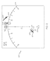
- the display 116 includes a display area 200 in which multiple graphical images may be simultaneously displayed, for example, a heading indicator 203.
- a top down view is depicted, it is understood that a vertical, or perspective, view could be depicted in accordance with the exemplary embodiments. Additional information (not shown) is typically provided in either graphic or numerical format.
- the display area 200 may also include navigational aids, such as a navigation reference and various map features (not shown) including, but not limited to, terrain, political boundaries, and terminal and special use airspace areas, which, for clarity, are not shown in FIG. 2 .
- a symbol 202 is displayed as the ownship which contains the flight deck display system 100. The location of the symbol 202 of the ownship may be determined, for example, from a GPS.
- Data is processed for the ownship and, when received for the other aircraft 204, 206, 208 transmitting aircraft related parameters, such as within the ADS-B system, transmitted directly from the aircraft 204, 206, 208, or a distal source (not shown) such as ground stations or satellites.
- the data comprises flight parameters including positional data (location and direction), speed, and aircraft type.
- An image representing each aircraft 204, 206, 208 is displayed on the display area 200 in a location determined by the positional data.
- the display of the identification numbers may be provided for aircraft 204, 206, 208, respectively, adjacent the aircraft's image 204, 206, 208, for example.
- Wake turbulences displayed may be limited to a predefined area, or envelope, such as within a specified distance from the flight path.
- the envelope may comprise, for example, 2 nm around the ownship, plus/minus 90 degrees of the track ahead to 20 nm.
- Another example comprises a horizontal distance of 40 nm in front of and 1 nm to the side of the ownship flight path, and an altitude of 3000 feet above and 1000 feet below the ownship flight path for example.
- the wake turbulences 205, 207, 209 of each aircraft 204, 206, 208, respectively, are displayed as being within the desired envelope and are a plurality of parallel spaced lines formed perpendicular to the direction of flight of its respective aircraft at the time of generation.
- the line segments representing the wake turbulences 205, 207, 209 typically will widen the further they are spaced from their respective aircraft 204, 206, 208 since that is the nature of wake turbulences - they "fan out" over time and distance as they age.
- the location of the generating aircraft is not relevant after generation of the wake segment.
- the line segments of the wake turbulences 205, 207, 209 are formatted for example by line style including thickness, type (dashed, solid), but are preferably colored, to represent a severity (magnitude) of the wake turbulences 205, 207, 209.
- the stronger wake turbulence 205, 207, 209 closer to the aircraft 204, 206, 208 may be colored red, for example, to indicate a severe turbulence, while the older wake segments may be colored yellow, for example, to indicate a moderate turbulence, and the oldest wake segments may be colored green, for example, to indicate light turbulence.
- the wake turbulence 205 contains severe turbulence 211, moderate turbulence 212, and light turbulence 213, which are indicated as such in this example by filled rectangles for severe turbulence 211, empty rectangles for moderate turbulence 212, and lines for light turbulence 213.
- the wake turbulences 205, 207, 209 are mostly aligned straight behind the aircraft 204, 206, 208 since the wind is only 15 knots (as indicated in the upper left of the display).
- an aircraft 308 has no wake turbulence and an aircraft 304 is producing a wake turbulence 305. Note how the wake turbulence 305 is not directly behind the aircraft's line of travel. This offset is due to a strong 95 knot wind that "pushes" the wake turbulence away from the aircraft's flight path.
- the wake turbulences 405, 407, 409 of each aircraft 404, 406, 408, respectively, are displayed as being within the desired envelope and are a plurality of parallel spaced lines formed perpendicular to the direction of flight of its respective aircraft.
- the wake turbulence 405 is being blown from the flight path of aircraft 404 by the strong cross wind of 95 knots similar to that of FIG. 3 .
- the wake turbulence 409 is curved indicating that the aircraft 408 has turned, or changed its heading.
- the wake turbulence 407 from aircraft 406 is short, indicating that the wake turbulence has only recently appeared within the envelope or may not be very strong.
- each displayed wake turbulence segment is defined by an algorithm.
- the format may include different displayed sizes, colors, or images. For example, the most severe wake turbulence may be a first color, a moderate wake turbulence may be a second color, while a mild wake turbulence may be a third color.
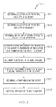
- FIG. 5 is a flow chart that illustrates an exemplary embodiment of a method 500 suitable for use with a flight deck display system 100.
- Method 500 represents one implementation of a method for displaying aircraft approaches or departures on an onboard display of an ownship.
- the various tasks performed in connection with method 500 may be performed by software, hardware, firmware, or any combination thereof.
- the following description of method 500 may refer to elements mentioned above in connection with preceding FIGS.
- portions of method 500 may be performed by different elements of the described system, e.g., a processor, a display element, or a data communication component. It should be appreciated that method 500 may include any number of additional or alternative tasks, the tasks shown in FIG.
- method 500 need not be performed in the illustrated order, and method 500 may be incorporated into a more comprehensive procedure or method having additional functionality not described in detail herein. Moreover, one or more of the tasks shown in FIG. 5 could be omitted from an embodiment of the method 500 as long as the intended overall functionality remains intact.
- method for displaying a wake turbulence of an aircraft with respect to an ownship includes determining 501 a location, flight parameters, and a type of an aircraft; determining 502 a location, flight parameters, and a type of the ownship; determining 503 an envelope of concern relating to a flight path of the ownship; determining 504 a wake turbulence within the envelope of an aircraft in consideration of the location, flight parameters, and the type of that aircraft; periodically determining 505 a decay rate of the wake turbulence; periodically 506 determining a severity of the wake turbulence with respect to the decay rate; determining 507 a format indicating the severity; and displaying 508 the format of the wake turbulence. This method would be accomplished for all relevant aircraft in the defined envelope.
Landscapes
- Engineering & Computer Science (AREA)
- Aviation & Aerospace Engineering (AREA)
- Physics & Mathematics (AREA)
- General Physics & Mathematics (AREA)
- Radar, Positioning & Navigation (AREA)
- Remote Sensing (AREA)
- Environmental & Geological Engineering (AREA)
- Life Sciences & Earth Sciences (AREA)
- Atmospheric Sciences (AREA)
- Biodiversity & Conservation Biology (AREA)
- Ecology (AREA)
- Environmental Sciences (AREA)
- Computer Networks & Wireless Communication (AREA)
- Electromagnetism (AREA)
- Automation & Control Theory (AREA)
- Traffic Control Systems (AREA)
- Radar Systems Or Details Thereof (AREA)
- Navigation (AREA)
Applications Claiming Priority (1)
| Application Number | Priority Date | Filing Date | Title |
|---|---|---|---|
| US14/035,114 US9037319B2 (en) | 2013-09-24 | 2013-09-24 | System and method for processing and displaying wake turbulence |
Publications (3)
| Publication Number | Publication Date |
|---|---|
| EP2851889A2 true EP2851889A2 (de) | 2015-03-25 |
| EP2851889A3 EP2851889A3 (de) | 2015-04-15 |
| EP2851889B1 EP2851889B1 (de) | 2016-08-24 |
Family
ID=51492225
Family Applications (1)
| Application Number | Title | Priority Date | Filing Date |
|---|---|---|---|
| EP14183943.1A Not-in-force EP2851889B1 (de) | 2013-09-24 | 2014-09-08 | System und Verfahren zum Verarbeiten und Anzeigen von Wirbelschleppen |
Country Status (3)
| Country | Link |
|---|---|
| US (1) | US9037319B2 (de) |
| EP (1) | EP2851889B1 (de) |
| CN (1) | CN104457782B (de) |
Cited By (5)
| Publication number | Priority date | Publication date | Assignee | Title |
|---|---|---|---|---|
| FR3065107A1 (fr) * | 2017-04-11 | 2018-10-12 | Airbus Operations (S.A.S.) | Procede de transmission de parametres de vol d'un aeronef meneur a un aeronef intrus |
| FR3065567A1 (fr) * | 2017-04-24 | 2018-10-26 | Airbus Operations (S.A.S.) | Procede de transmission de parametres de vol d'un aeronef meneur vers un aeronef intrus |
| US10884434B2 (en) | 2017-08-03 | 2021-01-05 | Airbus Operations (S.A.S.) | Method and device for controlling the path of a following aircraft, with respect to a leading aircraft, in front of the following aircraft, in particular when there is a risk of collision, the leading and following aircraft flying in formation |
| EP3971869A1 (de) * | 2020-09-22 | 2022-03-23 | Rockwell Collins, Inc. | Geschätzte wirbelschleppenspur für flugzeugsysteme |
| US11467607B2 (en) | 2018-04-04 | 2022-10-11 | Airbus Operations (S.A.S.) | Method and device for controlling trajectory of a follower aircraft |
Families Citing this family (23)
| Publication number | Priority date | Publication date | Assignee | Title |
|---|---|---|---|---|
| US9911342B2 (en) * | 2015-05-07 | 2018-03-06 | L3 Commmunications Avionics Systems, Inc. | Aircraft wake turbulence awareness |
| US20160347471A1 (en) * | 2015-05-26 | 2016-12-01 | Honeywell International Inc. | Modifying the appearance of an uplink message when the uplink message is affected by a flight information message |
| US9802713B2 (en) * | 2015-08-24 | 2017-10-31 | Honeywell International Inc. | Method and system for improving situational awareness of unanticipated yaw on a rotorcraft system |
| FR3051586B1 (fr) | 2016-05-19 | 2018-05-18 | Airbus Operations | Procede permettant d'identifier la proximite d'une turbulence de sillage et de generer un rapport relatif a cette proximite |
| CN109689503B (zh) * | 2016-07-11 | 2022-07-26 | 雅玛西有限公司 | 用于经由位于飞机上的通信设备获得和呈现湍流数据的方法和系统 |
| US10055998B1 (en) | 2017-08-25 | 2018-08-21 | Airbus Operations (S.A.S.) | Ground-based identification of wake turbulence encounters |
| CN109977436B (zh) * | 2017-12-27 | 2023-05-02 | 北京金风科创风电设备有限公司 | 湍流强度估算方法及装置 |
| US10446040B2 (en) | 2018-01-05 | 2019-10-15 | Honeywell International Inc. | Safe speed advisories for flight deck interval management (FIM) paired approach (PA) systems |
| CN108198462B (zh) * | 2018-01-25 | 2018-12-14 | 中国民航大学 | 一种全空域飞机尾流遭遇风险告警系统实现方法 |
| US11030908B2 (en) | 2018-05-17 | 2021-06-08 | Rockwell Collins, Inc. | System and method for identification and assessment of abnormal behavior of nearby aircraft |
| WO2020046998A1 (en) * | 2018-08-27 | 2020-03-05 | Gulfstream Aerospace Corporation | Avoidance of aircraft and aircraft wake during flight |
| US10876857B1 (en) | 2019-10-30 | 2020-12-29 | Honeywell International Inc. | Wake vortex display system |
| US11790794B2 (en) * | 2020-06-05 | 2023-10-17 | Apijet, Llc | System and method for community provided weather updates for aircraft |
| US11482123B2 (en) * | 2020-08-24 | 2022-10-25 | Rockwell Collins, Inc. | Sensor enhanced real time automatic pilot report (PIREP) generation |
| US12067889B2 (en) * | 2021-03-23 | 2024-08-20 | Honeywell International Inc. | Systems and methods for detect and avoid system for beyond visual line of sight operations of urban air mobility in airspace |
| US20230195116A1 (en) * | 2021-12-17 | 2023-06-22 | Honeywell International Inc. | Apparatuses, computer-implemented methods, and computer program products for generating intuitive data indicators for vehicle user interfaces |
| CN116189482B (zh) * | 2023-01-05 | 2025-08-08 | 青岛民航空管实业发展有限公司 | 基于民用航空器落地间隔规范的尾流监控系统及监控方法 |
| US12518641B2 (en) | 2023-05-10 | 2026-01-06 | Honeywell International Inc. | Systems and methods for generating avionic displays indicating wake turbulence |
| US12499776B2 (en) | 2023-05-18 | 2025-12-16 | Honeywell International Inc. | Method for weather information display and ADS-B/FIS-B weather and ADS-B tracks |
| US12584749B2 (en) | 2023-09-18 | 2026-03-24 | Apijet, Llc | Systems, apparatus and methods for aircraft flight planning and efficient communications with aircraft |
| CN117649785B (zh) * | 2023-11-28 | 2024-06-07 | 中国民航管理干部学院 | 一种无人机多运行人分布式协同冲突化解方法及系统 |
| US20250259557A1 (en) * | 2024-02-08 | 2025-08-14 | The Boeing Company | Wake turbulence alert systems and methods |
| US12510753B1 (en) * | 2025-02-18 | 2025-12-30 | John C. Kroack | Aircraft heads up display |
Family Cites Families (25)
| Publication number | Priority date | Publication date | Assignee | Title |
|---|---|---|---|---|
| US5262773A (en) | 1991-05-06 | 1993-11-16 | Gordon Andrew A | Method and apparatus for microburst and wake turbulence detection for airports |
| US5657009A (en) | 1991-10-31 | 1997-08-12 | Gordon; Andrew A. | System for detecting and viewing aircraft-hazardous incidents that may be encountered by aircraft landing or taking-off |
| US6501392B2 (en) * | 1998-02-09 | 2002-12-31 | Honeywell International Inc. | Aircraft weather information system |
| US6828922B1 (en) * | 1998-02-09 | 2004-12-07 | Honeywell International Inc. | Synthetic airborne hazard display |
| DE19836214C2 (de) | 1998-08-11 | 2000-08-24 | Dfs Deutsche Flugsicherung Gmb | Landeanflugverfahren für Luftfahrzeuge und Instrumentenlandeanlage zur Durchführung dieses Verfahrens |
| US6683541B2 (en) | 1999-01-21 | 2004-01-27 | Honeywell International Inc. | Vertical speed indicator and traffic alert collision avoidance system |
| US7411519B1 (en) | 1999-05-14 | 2008-08-12 | Honeywell International Inc. | System and method for predicting and displaying wake vortex turbulence |
| US6177888B1 (en) | 1999-09-08 | 2001-01-23 | The Boeing Company | Wake turbulence warning and caution system and method |
| US8135500B1 (en) * | 2000-05-26 | 2012-03-13 | Aerotech Research (Usa), Inc. | Wake vortex detection and reporting system |
| US7471995B1 (en) * | 2000-05-26 | 2008-12-30 | Aerotech Research (Usa), Inc. | Transmission, receipt, combination, sorting, and presentation of vehicle specific environmental conditions and hazards information |
| US8131407B1 (en) * | 2000-05-26 | 2012-03-06 | Aerotech Research (Usa), Inc. | Transmission, receipt, combination, sorting, reporting, and presentation of vehicle specific environmental conditions and hazards information utilizing a ground station |
| US7463955B1 (en) * | 2000-05-26 | 2008-12-09 | Aerotech Research (Usa), Inc. | Transmission, receipt, combination, sorting, and presentation of vehicle specific environmental conditions and hazards information |
| DE10039109A1 (de) | 2000-08-07 | 2002-02-28 | Gunther Schaenzer | Verfahren und Einrichtung zur Bestimmung des störenden Einflusses einer Wirbelschleppe |
| JP3570360B2 (ja) | 2000-08-31 | 2004-09-29 | 三菱電機株式会社 | 後方乱気流検出システム |
| JP3664066B2 (ja) | 2000-10-11 | 2005-06-22 | 三菱電機株式会社 | 航空管制支援システム |
| US6903752B2 (en) | 2001-07-16 | 2005-06-07 | Information Decision Technologies, Llc | Method to view unseen atmospheric phenomenon using augmented reality |
| US6963291B2 (en) | 2002-05-17 | 2005-11-08 | The Board Of Trustees Of The Leland Stanford Junior University | Dynamic wake prediction and visualization with uncertainty analysis |
| US7686253B2 (en) | 2006-08-10 | 2010-03-30 | The Boeing Company | Systems and methods for tracing aircraft vortices |
| FR2916280A1 (fr) | 2007-05-15 | 2008-11-21 | Thales Sa | Procede de surveillance radar des turbulences de sillage |
| JP5511196B2 (ja) | 2009-02-19 | 2014-06-04 | 三菱電機株式会社 | 後方乱気流検出装置 |
| US8362925B2 (en) | 2009-05-05 | 2013-01-29 | Honeywell International Inc. | Avionics display system and method for generating flight information pertaining to neighboring aircraft |
| US8665133B2 (en) * | 2010-02-04 | 2014-03-04 | Honeywell International Inc. | Methods and systems for presenting weather hazard information on an in-trail procedures display |
| FR2958032B1 (fr) | 2010-03-26 | 2012-03-30 | Thales Sa | Systeme et procede de detection de turbulences de sillage d'un aeronef |
| DE102011010147B3 (de) | 2011-02-02 | 2012-07-05 | Deutsches Zentrum für Luft- und Raumfahrt e.V. | Oberflächenstruktur einer Erdbodenoberfläche zur Beschleunigung des Zerfalls von Wirbelschleppen im Endteil eines Anflugs auf eine Landebahn |
| US9709698B2 (en) | 2011-06-10 | 2017-07-18 | Ohio University | Wake turbulence analyzer for real-time visualization, detection, and avoidance |
-
2013
- 2013-09-24 US US14/035,114 patent/US9037319B2/en active Active
-
2014
- 2014-09-08 EP EP14183943.1A patent/EP2851889B1/de not_active Not-in-force
- 2014-09-23 CN CN201410487589.2A patent/CN104457782B/zh not_active Expired - Fee Related
Non-Patent Citations (1)
| Title |
|---|
| None |
Cited By (10)
| Publication number | Priority date | Publication date | Assignee | Title |
|---|---|---|---|---|
| FR3065107A1 (fr) * | 2017-04-11 | 2018-10-12 | Airbus Operations (S.A.S.) | Procede de transmission de parametres de vol d'un aeronef meneur a un aeronef intrus |
| EP3388916A1 (de) * | 2017-04-11 | 2018-10-17 | Airbus Operations S.A.S. | Übertragungsverfahren von flugparametern von einem anführenden luftfahrzeug an ein eindringendes luftfahrzeug |
| US10170009B2 (en) | 2017-04-11 | 2019-01-01 | Airbus Operations (S.A.S.) | Method for transmitting flight parameters of a lead aircraft to an intruder aircraft |
| FR3065567A1 (fr) * | 2017-04-24 | 2018-10-26 | Airbus Operations (S.A.S.) | Procede de transmission de parametres de vol d'un aeronef meneur vers un aeronef intrus |
| EP3396651A1 (de) * | 2017-04-24 | 2018-10-31 | Airbus Operations S.A.S. | Übertragungsverfahren von flugparametern von einem anführenden luftfahrzeug an ein eindringendes luftfahrzeug |
| US10319238B2 (en) | 2017-04-24 | 2019-06-11 | Airbus Operations S.A.S. | Method for transmitting flight parameters from a leading aircraft to an intruding aircraft |
| US10884434B2 (en) | 2017-08-03 | 2021-01-05 | Airbus Operations (S.A.S.) | Method and device for controlling the path of a following aircraft, with respect to a leading aircraft, in front of the following aircraft, in particular when there is a risk of collision, the leading and following aircraft flying in formation |
| US11467607B2 (en) | 2018-04-04 | 2022-10-11 | Airbus Operations (S.A.S.) | Method and device for controlling trajectory of a follower aircraft |
| EP3971869A1 (de) * | 2020-09-22 | 2022-03-23 | Rockwell Collins, Inc. | Geschätzte wirbelschleppenspur für flugzeugsysteme |
| US11501647B2 (en) | 2020-09-22 | 2022-11-15 | Rockwell Collins, Inc. | Estimated wake turbulence trail for aircraft system |
Also Published As
| Publication number | Publication date |
|---|---|
| US9037319B2 (en) | 2015-05-19 |
| EP2851889A3 (de) | 2015-04-15 |
| CN104457782A (zh) | 2015-03-25 |
| CN104457782B (zh) | 2019-11-12 |
| US20150088342A1 (en) | 2015-03-26 |
| EP2851889B1 (de) | 2016-08-24 |
Similar Documents
| Publication | Publication Date | Title |
|---|---|---|
| US9037319B2 (en) | System and method for processing and displaying wake turbulence | |
| CN105549938B (zh) | 用于显示跑道着陆信息的系统和方法 | |
| US9499279B2 (en) | System and method for displaying runway approach information | |
| EP2869285B1 (de) | System und Verfahren zur Aufrechterhaltung des Flugzeugabstands basierend auf Entfernung oder Zeit | |
| EP2884478B1 (de) | System und Verfahren zur textuellen und grafischen Darstellung von Flugverkehrskontroll-Sprachinformationen | |
| EP2696171B1 (de) | Flugzeugsysteme und Verfahren zur Anzeige von Wetterinformationen entlang eines Flugweges | |
| US8160755B2 (en) | Displaying air traffic symbology based on relative importance | |
| US7917289B2 (en) | Perspective view primary flight display system and method with range lines | |
| US7295901B1 (en) | System and method for indicating a position of an aircraft to a user | |
| EP2980772B1 (de) | System und verfahren zur automatischen identifizierung von angezeigtem, von der flugsicherung erwähntem verkehr | |
| EP2775469B1 (de) | System und Verfahren zur Verwaltung eines Intervalls zwischen Flugzeugen | |
| EP2779140B1 (de) | System und Verfahren zur Alarmierung des Flugzeugpersonals vor Schwellenhöhen | |
| US8810435B2 (en) | Apparatus and method for displaying a helicopter approach to an airport landing pad | |
| EP1959239A1 (de) | System und Verfahren zur Anzeige einer Zielzone | |
| EP3023741B1 (de) | System und verfahren zur exozentrischen anzeige von integrierter navigation | |
| EP2940674A1 (de) | System und verfahren zur anzeige von kontextempfindlichen notizen | |
| EP2866112A2 (de) | System und Verfahren zur Modulation von Warnungen für eine ausgewählte Landebahn |
Legal Events
| Date | Code | Title | Description |
|---|---|---|---|
| PUAL | Search report despatched |
Free format text: ORIGINAL CODE: 0009013 |
|
| PUAI | Public reference made under article 153(3) epc to a published international application that has entered the european phase |
Free format text: ORIGINAL CODE: 0009012 |
|
| 17P | Request for examination filed |
Effective date: 20140908 |
|
| AK | Designated contracting states |
Kind code of ref document: A2 Designated state(s): AL AT BE BG CH CY CZ DE DK EE ES FI FR GB GR HR HU IE IS IT LI LT LU LV MC MK MT NL NO PL PT RO RS SE SI SK SM TR |
|
| AX | Request for extension of the european patent |
Extension state: BA ME |
|
| AK | Designated contracting states |
Kind code of ref document: A3 Designated state(s): AL AT BE BG CH CY CZ DE DK EE ES FI FR GB GR HR HU IE IS IT LI LT LU LV MC MK MT NL NO PL PT RO RS SE SI SK SM TR |
|
| AX | Request for extension of the european patent |
Extension state: BA ME |
|
| RIC1 | Information provided on ipc code assigned before grant |
Ipc: G08G 5/00 20060101AFI20150312BHEP |
|
| 17Q | First examination report despatched |
Effective date: 20150825 |
|
| RAP1 | Party data changed (applicant data changed or rights of an application transferred) |
Owner name: HONEYWELL INTERNATIONAL INC. |
|
| GRAP | Despatch of communication of intention to grant a patent |
Free format text: ORIGINAL CODE: EPIDOSNIGR1 |
|
| INTG | Intention to grant announced |
Effective date: 20160407 |
|
| GRAS | Grant fee paid |
Free format text: ORIGINAL CODE: EPIDOSNIGR3 |
|
| GRAA | (expected) grant |
Free format text: ORIGINAL CODE: 0009210 |
|
| AK | Designated contracting states |
Kind code of ref document: B1 Designated state(s): AL AT BE BG CH CY CZ DE DK EE ES FI FR GB GR HR HU IE IS IT LI LT LU LV MC MK MT NL NO PL PT RO RS SE SI SK SM TR |
|
| REG | Reference to a national code |
Ref country code: GB Ref legal event code: FG4D |
|
| REG | Reference to a national code |
Ref country code: CH Ref legal event code: EP |
|
| REG | Reference to a national code |
Ref country code: AT Ref legal event code: REF Ref document number: 823684 Country of ref document: AT Kind code of ref document: T Effective date: 20160915 |
|
| REG | Reference to a national code |
Ref country code: IE Ref legal event code: FG4D |
|
| REG | Reference to a national code |
Ref country code: FR Ref legal event code: PLFP Year of fee payment: 3 |
|
| REG | Reference to a national code |
Ref country code: DE Ref legal event code: R096 Ref document number: 602014003226 Country of ref document: DE |
|
| REG | Reference to a national code |
Ref country code: LT Ref legal event code: MG4D |
|
| REG | Reference to a national code |
Ref country code: NL Ref legal event code: MP Effective date: 20160824 |
|
| REG | Reference to a national code |
Ref country code: AT Ref legal event code: MK05 Ref document number: 823684 Country of ref document: AT Kind code of ref document: T Effective date: 20160824 |
|
| PG25 | Lapsed in a contracting state [announced via postgrant information from national office to epo] |
Ref country code: RS Free format text: LAPSE BECAUSE OF FAILURE TO SUBMIT A TRANSLATION OF THE DESCRIPTION OR TO PAY THE FEE WITHIN THE PRESCRIBED TIME-LIMIT Effective date: 20160824 Ref country code: FI Free format text: LAPSE BECAUSE OF FAILURE TO SUBMIT A TRANSLATION OF THE DESCRIPTION OR TO PAY THE FEE WITHIN THE PRESCRIBED TIME-LIMIT Effective date: 20160824 Ref country code: NO Free format text: LAPSE BECAUSE OF FAILURE TO SUBMIT A TRANSLATION OF THE DESCRIPTION OR TO PAY THE FEE WITHIN THE PRESCRIBED TIME-LIMIT Effective date: 20161124 Ref country code: NL Free format text: LAPSE BECAUSE OF FAILURE TO SUBMIT A TRANSLATION OF THE DESCRIPTION OR TO PAY THE FEE WITHIN THE PRESCRIBED TIME-LIMIT Effective date: 20160824 Ref country code: LT Free format text: LAPSE BECAUSE OF FAILURE TO SUBMIT A TRANSLATION OF THE DESCRIPTION OR TO PAY THE FEE WITHIN THE PRESCRIBED TIME-LIMIT Effective date: 20160824 Ref country code: IT Free format text: LAPSE BECAUSE OF FAILURE TO SUBMIT A TRANSLATION OF THE DESCRIPTION OR TO PAY THE FEE WITHIN THE PRESCRIBED TIME-LIMIT Effective date: 20160824 Ref country code: HR Free format text: LAPSE BECAUSE OF FAILURE TO SUBMIT A TRANSLATION OF THE DESCRIPTION OR TO PAY THE FEE WITHIN THE PRESCRIBED TIME-LIMIT Effective date: 20160824 |
|
| PG25 | Lapsed in a contracting state [announced via postgrant information from national office to epo] |
Ref country code: GR Free format text: LAPSE BECAUSE OF FAILURE TO SUBMIT A TRANSLATION OF THE DESCRIPTION OR TO PAY THE FEE WITHIN THE PRESCRIBED TIME-LIMIT Effective date: 20161125 Ref country code: LV Free format text: LAPSE BECAUSE OF FAILURE TO SUBMIT A TRANSLATION OF THE DESCRIPTION OR TO PAY THE FEE WITHIN THE PRESCRIBED TIME-LIMIT Effective date: 20160824 Ref country code: BE Free format text: LAPSE BECAUSE OF NON-PAYMENT OF DUE FEES Effective date: 20160930 Ref country code: SE Free format text: LAPSE BECAUSE OF FAILURE TO SUBMIT A TRANSLATION OF THE DESCRIPTION OR TO PAY THE FEE WITHIN THE PRESCRIBED TIME-LIMIT Effective date: 20160824 Ref country code: PT Free format text: LAPSE BECAUSE OF FAILURE TO SUBMIT A TRANSLATION OF THE DESCRIPTION OR TO PAY THE FEE WITHIN THE PRESCRIBED TIME-LIMIT Effective date: 20161226 Ref country code: AT Free format text: LAPSE BECAUSE OF FAILURE TO SUBMIT A TRANSLATION OF THE DESCRIPTION OR TO PAY THE FEE WITHIN THE PRESCRIBED TIME-LIMIT Effective date: 20160824 Ref country code: ES Free format text: LAPSE BECAUSE OF FAILURE TO SUBMIT A TRANSLATION OF THE DESCRIPTION OR TO PAY THE FEE WITHIN THE PRESCRIBED TIME-LIMIT Effective date: 20160824 |
|
| PG25 | Lapsed in a contracting state [announced via postgrant information from national office to epo] |
Ref country code: EE Free format text: LAPSE BECAUSE OF FAILURE TO SUBMIT A TRANSLATION OF THE DESCRIPTION OR TO PAY THE FEE WITHIN THE PRESCRIBED TIME-LIMIT Effective date: 20160824 Ref country code: RO Free format text: LAPSE BECAUSE OF FAILURE TO SUBMIT A TRANSLATION OF THE DESCRIPTION OR TO PAY THE FEE WITHIN THE PRESCRIBED TIME-LIMIT Effective date: 20160824 |
|
| REG | Reference to a national code |
Ref country code: DE Ref legal event code: R097 Ref document number: 602014003226 Country of ref document: DE |
|
| PG25 | Lapsed in a contracting state [announced via postgrant information from national office to epo] |
Ref country code: SM Free format text: LAPSE BECAUSE OF FAILURE TO SUBMIT A TRANSLATION OF THE DESCRIPTION OR TO PAY THE FEE WITHIN THE PRESCRIBED TIME-LIMIT Effective date: 20160824 Ref country code: BG Free format text: LAPSE BECAUSE OF FAILURE TO SUBMIT A TRANSLATION OF THE DESCRIPTION OR TO PAY THE FEE WITHIN THE PRESCRIBED TIME-LIMIT Effective date: 20161124 Ref country code: BE Free format text: LAPSE BECAUSE OF FAILURE TO SUBMIT A TRANSLATION OF THE DESCRIPTION OR TO PAY THE FEE WITHIN THE PRESCRIBED TIME-LIMIT Effective date: 20160824 Ref country code: DK Free format text: LAPSE BECAUSE OF FAILURE TO SUBMIT A TRANSLATION OF THE DESCRIPTION OR TO PAY THE FEE WITHIN THE PRESCRIBED TIME-LIMIT Effective date: 20160824 Ref country code: CZ Free format text: LAPSE BECAUSE OF FAILURE TO SUBMIT A TRANSLATION OF THE DESCRIPTION OR TO PAY THE FEE WITHIN THE PRESCRIBED TIME-LIMIT Effective date: 20160824 Ref country code: PL Free format text: LAPSE BECAUSE OF FAILURE TO SUBMIT A TRANSLATION OF THE DESCRIPTION OR TO PAY THE FEE WITHIN THE PRESCRIBED TIME-LIMIT Effective date: 20160824 Ref country code: SK Free format text: LAPSE BECAUSE OF FAILURE TO SUBMIT A TRANSLATION OF THE DESCRIPTION OR TO PAY THE FEE WITHIN THE PRESCRIBED TIME-LIMIT Effective date: 20160824 |
|
| REG | Reference to a national code |
Ref country code: IE Ref legal event code: MM4A |
|
| PG25 | Lapsed in a contracting state [announced via postgrant information from national office to epo] |
Ref country code: MC Free format text: LAPSE BECAUSE OF FAILURE TO SUBMIT A TRANSLATION OF THE DESCRIPTION OR TO PAY THE FEE WITHIN THE PRESCRIBED TIME-LIMIT Effective date: 20160824 |
|
| PLBE | No opposition filed within time limit |
Free format text: ORIGINAL CODE: 0009261 |
|
| STAA | Information on the status of an ep patent application or granted ep patent |
Free format text: STATUS: NO OPPOSITION FILED WITHIN TIME LIMIT |
|
| PG25 | Lapsed in a contracting state [announced via postgrant information from national office to epo] |
Ref country code: IE Free format text: LAPSE BECAUSE OF NON-PAYMENT OF DUE FEES Effective date: 20160908 |
|
| 26N | No opposition filed |
Effective date: 20170526 |
|
| PG25 | Lapsed in a contracting state [announced via postgrant information from national office to epo] |
Ref country code: LU Free format text: LAPSE BECAUSE OF NON-PAYMENT OF DUE FEES Effective date: 20160908 Ref country code: SI Free format text: LAPSE BECAUSE OF FAILURE TO SUBMIT A TRANSLATION OF THE DESCRIPTION OR TO PAY THE FEE WITHIN THE PRESCRIBED TIME-LIMIT Effective date: 20160824 |
|
| REG | Reference to a national code |
Ref country code: FR Ref legal event code: PLFP Year of fee payment: 4 |
|
| PGFP | Annual fee paid to national office [announced via postgrant information from national office to epo] |
Ref country code: DE Payment date: 20171130 Year of fee payment: 4 |
|
| REG | Reference to a national code |
Ref country code: CH Ref legal event code: PL |
|
| PG25 | Lapsed in a contracting state [announced via postgrant information from national office to epo] |
Ref country code: HU Free format text: LAPSE BECAUSE OF FAILURE TO SUBMIT A TRANSLATION OF THE DESCRIPTION OR TO PAY THE FEE WITHIN THE PRESCRIBED TIME-LIMIT; INVALID AB INITIO Effective date: 20140908 |
|
| PG25 | Lapsed in a contracting state [announced via postgrant information from national office to epo] |
Ref country code: IS Free format text: LAPSE BECAUSE OF FAILURE TO SUBMIT A TRANSLATION OF THE DESCRIPTION OR TO PAY THE FEE WITHIN THE PRESCRIBED TIME-LIMIT Effective date: 20160824 Ref country code: MK Free format text: LAPSE BECAUSE OF FAILURE TO SUBMIT A TRANSLATION OF THE DESCRIPTION OR TO PAY THE FEE WITHIN THE PRESCRIBED TIME-LIMIT Effective date: 20160824 Ref country code: CY Free format text: LAPSE BECAUSE OF FAILURE TO SUBMIT A TRANSLATION OF THE DESCRIPTION OR TO PAY THE FEE WITHIN THE PRESCRIBED TIME-LIMIT Effective date: 20160824 Ref country code: MT Free format text: LAPSE BECAUSE OF NON-PAYMENT OF DUE FEES Effective date: 20160930 |
|
| PG25 | Lapsed in a contracting state [announced via postgrant information from national office to epo] |
Ref country code: CH Free format text: LAPSE BECAUSE OF NON-PAYMENT OF DUE FEES Effective date: 20170930 Ref country code: LI Free format text: LAPSE BECAUSE OF NON-PAYMENT OF DUE FEES Effective date: 20170930 |
|
| REG | Reference to a national code |
Ref country code: FR Ref legal event code: PLFP Year of fee payment: 5 |
|
| PG25 | Lapsed in a contracting state [announced via postgrant information from national office to epo] |
Ref country code: AL Free format text: LAPSE BECAUSE OF FAILURE TO SUBMIT A TRANSLATION OF THE DESCRIPTION OR TO PAY THE FEE WITHIN THE PRESCRIBED TIME-LIMIT Effective date: 20160824 Ref country code: TR Free format text: LAPSE BECAUSE OF FAILURE TO SUBMIT A TRANSLATION OF THE DESCRIPTION OR TO PAY THE FEE WITHIN THE PRESCRIBED TIME-LIMIT Effective date: 20160824 |
|
| REG | Reference to a national code |
Ref country code: DE Ref legal event code: R119 Ref document number: 602014003226 Country of ref document: DE |
|
| GBPC | Gb: european patent ceased through non-payment of renewal fee |
Effective date: 20180908 |
|
| PG25 | Lapsed in a contracting state [announced via postgrant information from national office to epo] |
Ref country code: DE Free format text: LAPSE BECAUSE OF NON-PAYMENT OF DUE FEES Effective date: 20190402 |
|
| PG25 | Lapsed in a contracting state [announced via postgrant information from national office to epo] |
Ref country code: GB Free format text: LAPSE BECAUSE OF NON-PAYMENT OF DUE FEES Effective date: 20180908 |
|
| PGFP | Annual fee paid to national office [announced via postgrant information from national office to epo] |
Ref country code: FR Payment date: 20210927 Year of fee payment: 8 |
|
| P01 | Opt-out of the competence of the unified patent court (upc) registered |
Effective date: 20230525 |
|
| PG25 | Lapsed in a contracting state [announced via postgrant information from national office to epo] |
Ref country code: FR Free format text: LAPSE BECAUSE OF NON-PAYMENT OF DUE FEES Effective date: 20220930 |