EP2927875A2 - Procédé de détection de lumière sans perte progressive et compression de données de télémétrie (lidar) - Google Patents
Procédé de détection de lumière sans perte progressive et compression de données de télémétrie (lidar) Download PDFInfo
- Publication number
- EP2927875A2 EP2927875A2 EP15161444.3A EP15161444A EP2927875A2 EP 2927875 A2 EP2927875 A2 EP 2927875A2 EP 15161444 A EP15161444 A EP 15161444A EP 2927875 A2 EP2927875 A2 EP 2927875A2
- Authority
- EP
- European Patent Office
- Prior art keywords
- data
- points
- grid
- arrays
- levels
- Prior art date
- Legal status (The legal status is an assumption and is not a legal conclusion. Google has not performed a legal analysis and makes no representation as to the accuracy of the status listed.)
- Withdrawn
Links
Images


Classifications
-
- G—PHYSICS
- G06—COMPUTING OR CALCULATING; COUNTING
- G06T—IMAGE DATA PROCESSING OR GENERATION, IN GENERAL
- G06T9/00—Image coding
Definitions
- LiDAR Light detection and ranging
- LiDAR technology has been applied in various fields, as for example geography, geology, geomorphology, archaeology, seismology, atmospheric physics, and laser altimetry.
- LiDAR has been demonstrated successfully with wide range of targets including rocks, vegetation, metallic and non-metallic manmade objects, chemical compounds, aerosols and atmosphere.
- Ultraviolet, visible, or near infrared light may be used in LiDAR scanners. Due to the short wavelength of light, compared e.g. to other types of electromagnetic radiation, a high resolution may be achieved.
- LiDAR scanners are frequently mounted on aircrafts, helicopters and even on satellites; such airborne LiDAR systems are e.g. used to gather information about Earth's surface.
- the actual position of the LiDAR scanner at the airborne platform may be determined with the global positioning system (GPS), while an inertial measurement unit (IMU) may be used to monitor roll, pitch and heading of the aircraft to determine the angular orientation of the LiDAR scanner. From this information, a precise xyz-position of the hit target can be calculated in one of the geographical coordinate system (for example Universal Traverse Mercator coordinate system or Gauss-Kruger coordinate system). Up to 200.000 measurements per seconds have been achieved at the airborne platforms.
- GPS global positioning system
- IMU inertial measurement unit
- LiDAR Light Detection and Ranging
- Wiman and Quin Fast Compression and Access of LiDAR Point Clouds Using Wavelets, Joint Urban Remote Sensing Event, pp. 718-723, 2009 discloses application of wavelet transformation for compression of points obtained by LiDAR scanner.
- the transformation is applied independently in each of the xyz-coordinate directions.
- the consecutive LiDAR points have similar coefficients in the output vector, which can then allegedly be efficiently compressed.
- the approach is lossy. The method compresses only the xyz-coordinate of points, the remaining values stored in the LAS file are not considered.
- a commercial product for compression of LAS files is offered by LizardTechTM (http://www.lizardtech.com).
- the product supports lossless and lossy compression. However, details about the method are not known.
- a main objective and goal of the presented invention is to achieve a method for progressive compression of data files obtained by airborne laser scanning (LiDAR), such as LAS files, which allow gradual transfer of compressed data; firstly small quantities, which represent data at a lower resolution, and then remaining data that add additional details for viewing and processing at higher resolution.
- LiDAR airborne laser scanning
- the invention is especially useful in transmission of LiDAR data through the networks with limited bandwidth.
- Objectives of the invention are achieved by a method for progressive compression of LiDAR data, obtained from laser scanning and stored in a data file.
- the method comprising applying a two-dimensional hierarchical grid to input data points stored in the data file.
- the method further comprising distributing the input data points into arrays of various levels.
- the method comprises storing and compressing each of the arrays of various level separately, using well-known coding methods. In this way, the typically huge amount of data obtained, may be processed adequately to support progressive transmission of data through communication channels, e.g. to a ground facility.
- the data is prepared in the way that only a small part of it is sufficient for the rough visualization and preliminary processing in contrary to the conventional way, where the data have to be received entirely before they can be displayed and/or processed.
- the information is stored in different resolutions. The transmission starts with the lowest resolution requiring only a small amount of data, which are then gradually complete with adding remaining data.
- a bounding box around the input data points is recursively divided uniformly into the two-dimensional grid, whose grid-lines are assigned levels according to a depth of recursion i.e. number of successive divisions of the bounding box.
- a depth of recursion i.e. number of successive divisions of the bounding box.
- Our invention effectively distributes the input data points with the associated data into the hierarchically organized arrays of points, which may then be progressively transmitted while still achieving efficient compression and storage.
- the distribution of the input data points takes into account also the characteristics of data point attributes, such as data types. Therefore, it allows most favorable data compression for this type of data.
- each of the input data points from the data file are distributed into arrays corresponding to the level of the input data point, the level being assigned according to a position of the considered point in the two-dimensional grid.
- the level of the considered data point is determined from the grid lines that bound the considered grid cell within which the data point lie and the position of the grid cell of previously considered data point.
- the arrays of points with equal level are stored in order from higher to lower levels
- the arrays of points of the higher levels are stored using variable-length coding and arithmetic coding.
- the arrays of point of the lower levels are stored using also the prediction of values from non-progressive compression schema, variable-length coding, arithmetic coding.
- the data file is a raw (ASCII) file.
- ASCII raw (ASCII) file. This file format is also commonly used for storing LiDAR measurement data.
- the invention comprises a method for progressively compressing LiDAR data stored in a data file without pre-processing comprising:
- the presented invention constructs a hierarchical data model, where each level contains a set of points.
- the number of points increases from the higher levels to the lower ones.
- the higher levels represent data at lower resolutions that are progressively improved by adding points from the lower levels.
- M represents the number of points in the data file.
- the present inventive method may also be useful if the number of levels is chosen and/or calculated in other ways.
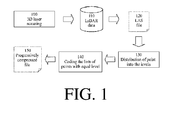
- the block diagram in Fig. 1 represents the basic flow in the process of progressive data file compression, as exemplified by a LAS file.
- the LiDAR data at block 110 are stored in the LAS file at the block 120.
- the distribution of the LAS points into the levels is performed.
- the arrays of points with equal level are coded and stored in the output file at the step 150.
- the set of points at a particular level has to be chosen simple enough that the algorithm can efficiently cope with the larger number of points.
- the most important constraint is the fact that the scanned points are stored in the LAS file according to the GPS time. Therefore, better results can be achieved if the order of the input points is preserved. This limits the possibilities of how to arrange the points into levels.
- the invention of progressive compression of LAS file at the block 200 consists from the following steps, which are semantically shown in Fig. 2 .
- a bounding box containing all considered points is obtained from the LAS file header.
- the bounding box is divided by the grid-lines into four equal parts named grid. The dividing process continues until the termination criterion (heuristically estimated number of levels) is met. In this way, grid-lines in each coordinate direction are inserted and the corresponding levels L 0 , L 1 , ..., L n are assigned to them (n is the depth of the recursion which is determined by choosing a number of desired levels.
- the detail presentation of the step 220 is shown in Fig. 3 .
- the grid after the first recursion is shown at the step 310.
- the second and the third steps are at 320 and 330, respectively.
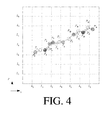
- the points from the LAS file can be arranged into different levels. For each point from the input file the steps 230, 240 and 250 are performed. At the beginning, the grid cell containing the first point from the LAS file is determined. Each grid cell is defined by four grid-lines (left, right, top and bottom). The level of the first point is determined as the level of the left line of the considered grid cell (for example, the level of the point P 0 in Fig. 4 is L 2 ).
- next point is located in the same grid cell, then it is allocated in the lowest ( L n ) level (point P 1 in Fig. 4 gets level L n ).
- the grid cell containing the next point is determined. If the new grid cell lies on the left-side from the previous cell, the level of the next point is determined according to the level of the right grid-line. Similarly, if the new grid cell lies on the right-side from the previous cell, the level of the next point is determined as the level of the left grid-line (the level of the point P 2 in Fig. 4 becomes L 1 in this way). If the position of the new grid cell in the x direction remains the same, then the y direction is used. Thus, if the new grid cell is on the top-side of the previous cell, the level of the considered point is determined as the level of the bottom grid-line. Similarly, if the new grid cell lies on the bottom-side in regards to the previous cell, the level of the point is determined as the level of the top grid-line (the level of the point P 4 in Fig. 4 is P o).
- the points after being arranged in the levels, are stored in arrays, as schematically shown in Fig. 5 .
- the points in the arrays remain sorted according to GPS time, and may therefore be compressed simply and efficiently.
- the point coordinates have also been arranged into levels in way that is very convenient for compression. It can be expected that the distances in the x direction between two successive points within the same level are very similar (see, for example, points P o, P s, P 10 and P 16 in Fig. 5 ) and approximately equal to the distances between the grid-lines at the considered level. As the difference between these distances is small, it can be compressed efficiently.
- the arrays of LAS points are then compressed and stored in order from the higher ( L 0 ) to the lower levels ( L n ).
- the successive points from the arrays of the higher levels may be compressed by a variable length coding and arithmetic coding.
- the arrays at the lower levels containing the larger sets of points are close enough that the prediction model proposed by Mongus and Zalik in their method of lossless non-progressive compression, »Efficient method for lossless LiDAR data compression «, International Journal of Remote Sensing, 32 (9), 2011, pp. 2507-2518 , is applied before variable length coding and arithmetic coding.
- the progressively compressed file is obtained.
Landscapes
- Engineering & Computer Science (AREA)
- Multimedia (AREA)
- Physics & Mathematics (AREA)
- General Physics & Mathematics (AREA)
- Theoretical Computer Science (AREA)
- Optical Radar Systems And Details Thereof (AREA)
- Compression Of Band Width Or Redundancy In Fax (AREA)
- Compression, Expansion, Code Conversion, And Decoders (AREA)
Applications Claiming Priority (1)
| Application Number | Priority Date | Filing Date | Title |
|---|---|---|---|
| SI201400125A SI24693A (sl) | 2014-03-31 | 2014-03-31 | Postopek za progresivno brezizgubno stiskanje podatkov, pridobljenih s prostorskimi laserskimi prebirniki |
Publications (2)
| Publication Number | Publication Date |
|---|---|
| EP2927875A2 true EP2927875A2 (fr) | 2015-10-07 |
| EP2927875A3 EP2927875A3 (fr) | 2015-12-23 |
Family
ID=52875487
Family Applications (1)
| Application Number | Title | Priority Date | Filing Date |
|---|---|---|---|
| EP15161444.3A Withdrawn EP2927875A3 (fr) | 2014-03-31 | 2015-03-27 | Procédé de détection de lumière sans perte progressive et compression de données de télémétrie (lidar) |
Country Status (2)
| Country | Link |
|---|---|
| EP (1) | EP2927875A3 (fr) |
| SI (1) | SI24693A (fr) |
Cited By (2)
| Publication number | Priority date | Publication date | Assignee | Title |
|---|---|---|---|---|
| CN110869981A (zh) * | 2016-12-30 | 2020-03-06 | 迪普迈普有限公司 | 用于自主车辆的高清晰度地图数据的向量数据编码 |
| CN111649729A (zh) * | 2020-05-16 | 2020-09-11 | 阿勒泰正元国际矿业有限公司 | 一种基于三维激光扫描的矿山采空区探测方法 |
Citations (9)
| Publication number | Priority date | Publication date | Assignee | Title |
|---|---|---|---|---|
| US5418532A (en) | 1993-05-13 | 1995-05-23 | Bell Communications Research, Inc. | Method and system for efficient, multiplication-free arithmetic coding |
| US5546080A (en) | 1994-01-03 | 1996-08-13 | International Business Machines Corporation | Order-preserving, fast-decoding arithmetic coding arithmetic coding and compression method and apparatus |
| US5793371A (en) | 1995-08-04 | 1998-08-11 | Sun Microsystems, Inc. | Method and apparatus for geometric compression of three-dimensional graphics data |
| WO2000077740A1 (fr) | 1999-06-14 | 2000-12-21 | Sun Microsystems, Inc. | Compression geometrique de donnees graphiques tridimensionnelles |
| US6314205B1 (en) | 1997-07-23 | 2001-11-06 | International Business Machines Corporation | Method and apparatus for compressing and transmitting a three-dimensional geometric model |
| US7187452B2 (en) | 2001-02-09 | 2007-03-06 | Commonwealth Scientific And Industrial Research Organisation | Lidar system and method |
| US7701558B2 (en) | 2006-09-22 | 2010-04-20 | Leica Geosystems Ag | LIDAR system |
| US7737870B1 (en) | 2007-09-04 | 2010-06-15 | Nortel Networks Limited | Bit-stream huffman coding for data compression |
| US7746449B2 (en) | 2007-11-14 | 2010-06-29 | Rosemount Aerospace Inc. | Light detection and ranging system |
-
2014
- 2014-03-31 SI SI201400125A patent/SI24693A/sl not_active IP Right Cessation
-
2015
- 2015-03-27 EP EP15161444.3A patent/EP2927875A3/fr not_active Withdrawn
Patent Citations (13)
| Publication number | Priority date | Publication date | Assignee | Title |
|---|---|---|---|---|
| US5418532A (en) | 1993-05-13 | 1995-05-23 | Bell Communications Research, Inc. | Method and system for efficient, multiplication-free arithmetic coding |
| US5546080A (en) | 1994-01-03 | 1996-08-13 | International Business Machines Corporation | Order-preserving, fast-decoding arithmetic coding arithmetic coding and compression method and apparatus |
| US6239805B1 (en) | 1995-08-04 | 2001-05-29 | Sun Microsystems, Inc. | Method and apparatus for geometric compression of three-dimensional graphics data |
| US5867167A (en) | 1995-08-04 | 1999-02-02 | Sun Microsystems, Inc. | Compression of three-dimensional graphics data including quantization, delta-encoding, and variable-length encoding |
| US5870094A (en) | 1995-08-04 | 1999-02-09 | Sun Microsystems, Inc. | System and method for transferring compressed three-dimensional graphics data |
| US5793371A (en) | 1995-08-04 | 1998-08-11 | Sun Microsystems, Inc. | Method and apparatus for geometric compression of three-dimensional graphics data |
| US20020050992A1 (en) | 1995-08-04 | 2002-05-02 | Sun Microsystems, Inc., | Geometry instructions for graphics data compression |
| US6314205B1 (en) | 1997-07-23 | 2001-11-06 | International Business Machines Corporation | Method and apparatus for compressing and transmitting a three-dimensional geometric model |
| WO2000077740A1 (fr) | 1999-06-14 | 2000-12-21 | Sun Microsystems, Inc. | Compression geometrique de donnees graphiques tridimensionnelles |
| US7187452B2 (en) | 2001-02-09 | 2007-03-06 | Commonwealth Scientific And Industrial Research Organisation | Lidar system and method |
| US7701558B2 (en) | 2006-09-22 | 2010-04-20 | Leica Geosystems Ag | LIDAR system |
| US7737870B1 (en) | 2007-09-04 | 2010-06-15 | Nortel Networks Limited | Bit-stream huffman coding for data compression |
| US7746449B2 (en) | 2007-11-14 | 2010-06-29 | Rosemount Aerospace Inc. | Light detection and ranging system |
Non-Patent Citations (8)
| Title |
|---|
| DAVID SALOMON: "Data Compression: The Complete Reference", 2007, SPRINGER VERLAG |
| HUFFMAN: "A Method for the Construction of Minimum-Redundancy Codes", PROC. OF THE I.R.E., 1952, pages 1098 - 1102 |
| ISENBURG; LASZIP: "Lossless compression of LiDAR data", PHOTOGRAMMETRIC ENGINEERING AND REMOTE SENSING, vol. 79, no. 2, 2013, pages 209 - 217 |
| LIPUS; 2ALIK: "Lossy LAS file compression using uniform space division", ELECTRONICS LETTERS, vol. 48, no. 20, 2012, pages 1278 - 1279, XP006039595, DOI: doi:10.1049/el.2012.1080 |
| MONGUS; 2ALIK: "Efficient method for lossless LiDAR data compression", INTERNATIONAL JOURNAL OF REMOTE SENSING, vol. 32, no. 9, 2011, pages 2507 - 2518 |
| MONGUS; AIK: "Efficient method for lossless LiDAR data compression", INTERNATIONAL JOURNAL OF REMOTE SENSING, vol. 32, no. 9, 2011, pages 2507 - 2518 |
| PRADHAN; KUMAR; MANSOR; RAMLI; SHARIF: "Light Detection and Ranging (LiDAR) data compression", KMITL SCIENCE AND TECHNOLOGY JOURNAL, 2005, pages 515 - 526 |
| WIMAN; QUIN: "Fast Compression and Access of LiDAR Point Clouds Using Wavelets", JOINT URBAN REMOTE SENSING EVENT, 2009, pages 718 - 723 |
Cited By (5)
| Publication number | Priority date | Publication date | Assignee | Title |
|---|---|---|---|---|
| CN110869981A (zh) * | 2016-12-30 | 2020-03-06 | 迪普迈普有限公司 | 用于自主车辆的高清晰度地图数据的向量数据编码 |
| US11754716B2 (en) | 2016-12-30 | 2023-09-12 | Nvidia Corporation | Encoding LiDAR scanned data for generating high definition maps for autonomous vehicles |
| CN110869981B (zh) * | 2016-12-30 | 2023-12-01 | 辉达公司 | 用于自主车辆的高清晰度地图数据的向量数据编码 |
| US12092742B2 (en) | 2016-12-30 | 2024-09-17 | Nvidia Corporation | Encoding LiDAR scanned data for generating high definition maps for autonomous vehicles |
| CN111649729A (zh) * | 2020-05-16 | 2020-09-11 | 阿勒泰正元国际矿业有限公司 | 一种基于三维激光扫描的矿山采空区探测方法 |
Also Published As
| Publication number | Publication date |
|---|---|
| EP2927875A3 (fr) | 2015-12-23 |
| SI24693A (sl) | 2015-10-30 |
Similar Documents
| Publication | Publication Date | Title |
|---|---|---|
| US11010930B2 (en) | Indexation of massive point cloud data for efficient visualization | |
| Klein et al. | PAIRS: A scalable geo-spatial data analytics platform | |
| US9330435B2 (en) | Bare earth finding and feature extraction for 3D point clouds | |
| KR101325926B1 (ko) | 실시간 3d 데이터 송수신을 위한 3d 데이터 처리 장치 및 방법 | |
| US9633472B2 (en) | Master model for data related to a spatial region | |
| Favorskaya et al. | Handbook on advances in remote sensing and geographic information systems | |
| US20100182316A1 (en) | Geospatial modeling system for 3d clutter data and related methods | |
| Åstrand et al. | The potential of WorldView-2 for ortho-image production within the “Control with Remote Sensing Programme” of the European Commission | |
| EP2927875A2 (fr) | Procédé de détection de lumière sans perte progressive et compression de données de télémétrie (lidar) | |
| Fernandez et al. | An overview of lidar point cloud processing software | |
| Kreylos et al. | Point-based computing on scanned terrain with LidarViewer | |
| Sefercik et al. | Area-based quality control of airborne laser scanning 3D models for different land classes using terrestrial laser scanning: sample survey in Houston, USA | |
| Lastilla et al. | First test of Agisoft Metashape satellite image processing for DSM generation: A case study in Trento with Pléiades imagery | |
| Scarmana | Lossless data compression of grid-based digital elevation models: A PNG image format evaluation | |
| Dzeroski et al. | Using Decision Trees to Predict Forest Stand Height and Canopy Cover from LANDSAT and LIDAR Data. | |
| Luh et al. | High resolution survey for topographic surveying | |
| Gurram et al. | Uniform grid upsampling of 3D lidar point cloud data | |
| Kiema et al. | Wavelet compression and the automatic classification of urban environments using high resolution multispectral imagery and laser scanning data | |
| Toutin et al. | Fusion of Radarsat-2 polarimetric images for improved stereo-radargrammetric DEM | |
| Vlach et al. | Enhancing Remote Sensing Based Machine Learning Applications through Analysis Ready Data: A Comprehensive Review | |
| WO2022097219A1 (fr) | Procédé de détection, dispositif de détection et programme | |
| Ali | Building of robust multi-scale representations of LiDAR-based digital terrain model based on scale-space theory | |
| Yu et al. | Automatic feature extraction and stereo image processing with genetic algorithms for LiDAR data | |
| Kobler et al. | REIN algorithm and the influence of point cloud density on NDSM and DEM precision in a submediterranean forest | |
| Subora | A decade of topographic transformation: Statewide elevation differencing from public LiDAR data and the relationship to landscape patterns |
Legal Events
| Date | Code | Title | Description |
|---|---|---|---|
| PUAI | Public reference made under article 153(3) epc to a published international application that has entered the european phase |
Free format text: ORIGINAL CODE: 0009012 |
|
| AK | Designated contracting states |
Kind code of ref document: A2 Designated state(s): AL AT BE BG CH CY CZ DE DK EE ES FI FR GB GR HR HU IE IS IT LI LT LU LV MC MK MT NL NO PL PT RO RS SE SI SK SM TR |
|
| AX | Request for extension of the european patent |
Extension state: BA ME |
|
| PUAL | Search report despatched |
Free format text: ORIGINAL CODE: 0009013 |
|
| AK | Designated contracting states |
Kind code of ref document: A3 Designated state(s): AL AT BE BG CH CY CZ DE DK EE ES FI FR GB GR HR HU IE IS IT LI LT LU LV MC MK MT NL NO PL PT RO RS SE SI SK SM TR |
|
| AX | Request for extension of the european patent |
Extension state: BA ME |
|
| RIC1 | Information provided on ipc code assigned before grant |
Ipc: G06T 9/00 20060101AFI20151119BHEP |
|
| 17P | Request for examination filed |
Effective date: 20160615 |
|
| RBV | Designated contracting states (corrected) |
Designated state(s): AL AT BE BG CH CY CZ DE DK EE ES FI FR GB GR HR HU IE IS IT LI LT LU LV MC MK MT NL NO PL PT RO RS SE SI SK SM TR |
|
| 17Q | First examination report despatched |
Effective date: 20170620 |
|
| STAA | Information on the status of an ep patent application or granted ep patent |
Free format text: STATUS: THE APPLICATION IS DEEMED TO BE WITHDRAWN |
|
| 18D | Application deemed to be withdrawn |
Effective date: 20181002 |