EP2932193B1 - Système de codage pour système de navigation par satellite - Google Patents
Système de codage pour système de navigation par satellite Download PDFInfo
- Publication number
- EP2932193B1 EP2932193B1 EP13862907.6A EP13862907A EP2932193B1 EP 2932193 B1 EP2932193 B1 EP 2932193B1 EP 13862907 A EP13862907 A EP 13862907A EP 2932193 B1 EP2932193 B1 EP 2932193B1
- Authority
- EP
- European Patent Office
- Prior art keywords
- code
- address
- location
- group
- assigned
- Prior art date
- Legal status (The legal status is an assumption and is not a legal conclusion. Google has not performed a legal analysis and makes no representation as to the accuracy of the status listed.)
- Active
Links
Images


Classifications
-
- G—PHYSICS
- G01—MEASURING; TESTING
- G01C—MEASURING DISTANCES, LEVELS OR BEARINGS; SURVEYING; NAVIGATION; GYROSCOPIC INSTRUMENTS; PHOTOGRAMMETRY OR VIDEOGRAMMETRY
- G01C21/00—Navigation; Navigational instruments not provided for in groups G01C1/00 - G01C19/00
- G01C21/38—Electronic maps specially adapted for navigation; Updating thereof
- G01C21/3804—Creation or updating of map data
- G01C21/3807—Creation or updating of map data characterised by the type of data
- G01C21/3811—Point data, e.g. Point of Interest [POI]
-
- G—PHYSICS
- G01—MEASURING; TESTING
- G01C—MEASURING DISTANCES, LEVELS OR BEARINGS; SURVEYING; NAVIGATION; GYROSCOPIC INSTRUMENTS; PHOTOGRAMMETRY OR VIDEOGRAMMETRY
- G01C21/00—Navigation; Navigational instruments not provided for in groups G01C1/00 - G01C19/00
- G01C21/26—Navigation; Navigational instruments not provided for in groups G01C1/00 - G01C19/00 specially adapted for navigation in a road network
- G01C21/34—Route searching; Route guidance
- G01C21/36—Input/output arrangements for on-board computers
- G01C21/3605—Destination input or retrieval
- G01C21/3617—Destination input or retrieval using user history, behaviour, conditions or preferences, e.g. predicted or inferred from previous use or current movement
-
- G—PHYSICS
- G01—MEASURING; TESTING
- G01C—MEASURING DISTANCES, LEVELS OR BEARINGS; SURVEYING; NAVIGATION; GYROSCOPIC INSTRUMENTS; PHOTOGRAMMETRY OR VIDEOGRAMMETRY
- G01C21/00—Navigation; Navigational instruments not provided for in groups G01C1/00 - G01C19/00
- G01C21/38—Electronic maps specially adapted for navigation; Updating thereof
- G01C21/3863—Structures of map data
- G01C21/387—Organisation of map data, e.g. version management or database structures
- G01C21/3874—Structures specially adapted for data searching and retrieval
-
- G—PHYSICS
- G06—COMPUTING OR CALCULATING; COUNTING
- G06F—ELECTRIC DIGITAL DATA PROCESSING
- G06F16/00—Information retrieval; Database structures therefor; File system structures therefor
-
- G—PHYSICS
- G06—COMPUTING OR CALCULATING; COUNTING
- G06F—ELECTRIC DIGITAL DATA PROCESSING
- G06F16/00—Information retrieval; Database structures therefor; File system structures therefor
- G06F16/20—Information retrieval; Database structures therefor; File system structures therefor of structured data, e.g. relational data
- G06F16/29—Geographical information databases
-
- G—PHYSICS
- G06—COMPUTING OR CALCULATING; COUNTING
- G06F—ELECTRIC DIGITAL DATA PROCESSING
- G06F16/00—Information retrieval; Database structures therefor; File system structures therefor
- G06F16/90—Details of database functions independent of the retrieved data types
- G06F16/95—Retrieval from the web
- G06F16/953—Querying, e.g. by the use of web search engines
- G06F16/9537—Spatial or temporal dependent retrieval, e.g. spatiotemporal queries
Definitions
- the satnav system will make an estimation.
- a desired address is 300 Main Street.
- the database does not contain the exact latitude and longitude of this address.
- the database contains the information that Main Street is 900 meters long and starts at Point A (specified by latitude and longitude), with house numbers beginning with 100, and ends at Point B (specified by latitude and longitude) with house number 160, 60 house numbers away.
- Point A specified by latitude and longitude
- Point B specified by latitude and longitude
- house number 160 60 house numbers away.
- countries are divided up into smaller Administrative Divisions to make managing their land and the affairs of their people easier.
- a country may be divided into provinces, which in turn are divided into counties, which in turn may be divided in whole or in part into municipalities.
- the first division of a Country into smaller subnational units, e.g. states in the United States of America or provinces in Canada, is considered to be a First Level Administrative Division.
- First Level Administrative Divisions are divided into Second Level Administrative Divisions, such as counties or municipalities, which are further sub-divided into Third Level Administrative Divisions such as towns and hamlets.
- Canada is divided into ten provinces and three territories.
- the 50 states (four of which have the official title of Commonwealth) are subdivided into counties (Louisiana uses the title “parish” and Alaska uses the title “borough”). The counties may be further subdivided into townships, or towns in New York State and most of New England. Urban areas of a state may be organized into incorporated cities, towns, villages, and other types of municipalities, and other autonomous or subordinate public authorities and institutions.
- PUMAs and Super-PUMAs can be used to divide counties (greater than 1,800,000). There are only 15 counties in USA with a population greater than 1,800,000. Mexic o 31 federal states (estados) Mexico City 2400+ municipalities (average population of 45,616 16 boroughs (delegaations) in Mexico City Municipalities are divided into Circuits (delegaations)
- a geocoder (noun) is a set of inter-related components in the form of operations, algorithms, and data sources that work together to produce a geocode.
- a geotag is a code and corresponding pair of latitude and longitude coordinates that can be used to identify and to locate a point on the earth's surface, typically an address or other textually described location.
- the code is frequently an alphanumeric string. This string may vary in length depending on the coding method used.
- To geotag is the process of assigning a code and a corresponding pair of latitude and longitude coordinates to a particular location, typically an address or a Point of Interest (e.g. the statue of Liberty in New York City)
- Each such geotag consists of a code which is 11 or 12 characters in length and the geocode, the latitude/longitude pairs for the location, typically 16 or 18 characters. This results in a geotag which is 27 to 30 characters long. A geotag of this length is much too long to be used by a normal consumer with a typical satnav device.
- This method of geotagging enables any physical location or an actual postal address to be geocoded in only five or six alphanumeric characters.
- a representative example of such a geotag is L6-B4S3 or L6-223, plus the geocode (the latitude/longitude pair) that gives the exact location of the address in question.
- the dash (-) shown in the representative geotags is only included to make the geotag more legible.
- a software program using these geotags may readily remove or add the dash and any other unnecessary characters entered by the user. This would allow the geotags to be displayed in a variety of ways (including dashes and spaces as an example) designed to enhance the legibility of the geotag.
- a QCODE geotag is an alphanumeric code. Using the QCODE encoding (or geotagging) process, geotags are assigned to specific locations such as addresses or Points of Interest (POIs). Associated with the geotag is a latitude/longitude pair that identifies the location. Additional information could be associated with the geotag, such as the phone number of the location, other unique identifiers such as a property record identifier, etc. The inclusion of this additional information could be useful in various applications.
- a QCODE geotag consists of two parts, a QCODE code and the latitude/longitude pair for the location associated with the code.
- A2-CD2H +38.803213, -77.063371 (example only). This would be the QCODE geotag for "the main entrance of the Jefferson Building, part of the USPTO, in Alexandria Virginia.”
- a QCODE geotag consists of four parts, a group code, a region code a location code and an extended location code.
- the region code and location code are a core code and the group code and extended location code are an ancillary code.
- a group code is a three character alphabetic code.
- countries are assigned to a group in a logical manner based on the likely use of a satnav device within that area. For example, Canada, USA and Mexico are assigned to the North America group. All countries in Europe are assigned to the Europe group.
- the group code is not seen or used by the human user of a the geotag.
- the satnav device determines itself in which group it is located, and then uses the database for that group to look up the QCODE geotag and return the latitude/longitude pair for the desired location.
- a region code is a two character alphanumeric code.
- contiguous Second Level Administrative Divisions (for example, in the USA these divisions are for the most part called counties) are grouped together into what are called regions and assigned a unique region code. Regions may include Second Level Administrative Divisions located in different First Level Administrative Divisions. As an example, in the United States, First Level Administrative Divisions are normally States. For example, in the USA, counties from more than one state (a state is a First Level Administrative Division) may be grouped together.
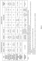
- Figure 2A provides information regarding a preferred embodiment of the 6 character embodiment of this invention.
- Figure 2B provides additional detail for a preferred embodiment of the 5 character embodiment.
- the geotagging method is a process by which pre-existing geocodes are paired with a unique code (a QCODE geocode) to form a QCODE geotag.
- the code is typically, but not limited to, six alphanumeric characters.
- a QCODE code can be assigned to more than one geocode. In other words, the QCODE code can be re-used. When a QCODE code is reused it is done in such a way that has no adverse effects on its use with satellite navigation devices used under normal circumstances.
- geotags have been specifically designed for, but are not limited to, use in consumer navigation devices.
- geotags Use of these geotags requires the use of a database that contains of all geotags for the region of the world in which it is used.
- a QCODE code When a QCODE code is entered into, for example, a consumer satellite navigation device, the device does a "look-up" in the database to find the latitude/longitude coordinates (the geocode) associated with that code.
- the satnav device then knows the coordinates of the desired destination and can plot a path accordingly.
- the QCODE geotagging method assigns to pre-existing geocodes a geotag that consists of two elements, a QCODE code and the pre-existing latitude and longitude coordinates of the address or location.
- the standard QCODE geotagging method can produce geotags that have a QCODE code of five or six characters because it makes use of two key factors.
- the QCODE geotagging method makes use of the ability of a satnav device to calculate where it is located on the face of the earth. Using this factor allows the QCODE geotagging method to "re-use" codes geotags.
- the code geotag, AB-CDEF could be used in the North America group, the Europe group, and other groups as well.
- the software of the satnav device is designed such that after the code is entered and an address is retrieved by the device, the address is presented to the user for final confirmation that the desired address has been retrieved.
- each of these large areas would be considered to be part of a separate or different group. It is assumed that the user of a satnav device who uses a QCODE geotags would never expect the device to give him/her driving direction from South Africa to the UK. Therefore addresses located within the user's current geographic group would be selected preferentially.
- the QCODE geotagging method has the capacity within the 6 character limit to create unique geotags for each of the 50 apartments should that be desired.
- the complete QCODE geotag database may be stored locally (e.g. in the memory of a satnav system) or remotely (e.g. on a centralized database server, such as a Google server).
- a user may input the code of his desired destination.
- the smartphone then transmits a data packet to a remote server (i.e. a Google server).
- This data packet need only contain two items of information: the code entered, and the code (a maximum of three characters) for the group (as determined by the QCODE geocoding method) where the smartphone is located.
- the remote server performs a lookup in the database of QCODE geotags for the geographical group (for example, North America) where the smartphone is located and then transmits back to the smartphone the geotag (a latitude/longitude pair up to a maximum of 18 characters (assuming a 5 decimal place/one meter accuracy)). This is a very small packet of data and thus very cost effective.
- the smartphone software then calculates directions to the desired location in the same way as if the user had actually entered the latitude/longitude coordinates themselves.
- a six character alpha-numeric string (26 alphabetic characters and ten numbers for a total of 36 characters) yields approximately 2.2 billion permutations (36 to the 6th power). This number is far larger than the number of addresses that need to be assigned a code within any particular group and accordingly all addresses located within an area represented by a particular group can be assigned a unique geotag.
- Satnav systems are just beginning to be used to locate points within large buildings such as a shopping mall or airport.
- the QCODE system has enough expansion capability to accommodate this increase in "addresses.”
- the QCODE geotagging method marks a distinct advancement beyond other geotagging systems.
- the QCODE geotagging method requires only 6 characters to geotag all addresses on the earth, where other systems require more than 6 characters.
- the accuracy of the this method of geotagging is only limited by the accuracy provided by the GPS system. Other systems require additional characters to geotag to higher degrees of location accuracy.
- Galileo satellite navigation system
- a specific database may be used and the boundaries of all Administrative Levels may be fixed which may allow for the initial assignment of a code to an address. If in the future the boundaries of a Level 2, 3, or 4 Administrative Division change, any new addresses located within the new boundaries may be encoded without requiring any change to the geotags assigned to any previous addresses.
- the QCODE geotagging method allows for any foreseeable expansion of new addresses or POls.
- the satnav device typically will have some sort of bulk data input capability, e. g. a memory stick or a SD memory card similar to those used in smartphones or digital cameras. This is used to load updated maps, software, QCODE geotags, etc. into the map and program device.
- some sort of bulk data input capability e. g. a memory stick or a SD memory card similar to those used in smartphones or digital cameras. This is used to load updated maps, software, QCODE geotags, etc. into the map and program device.
- All satnav devices have a method for the user to input data via the user input device. This may be a keyboard on a touch-screen display, or other such device, which is used by the user to input data, such as the desired destination.
- Various embodiments of the present invention provide a method, hereafter referred to as the QCODE method of geotagging, to encode all addresses or other points of interest that a user might want to navigate to with a code designed such that the user may enter a code consisting of five or six characters into a satnav navigation system and the satnav navigation system can identify the unique location corresponding to the code entered.
- .A code may also comprise an extended location code comprised of four alphanumeric characters.
- the characters in a standard code are limited to the characters in the base character set.
- the base character set contains (a) all uppercase letters in the English alphabet excluding "O" and "I” and (b) the numbers 2 through 9. The numbers 0 and 1 are removed to prevent confusion with O and I from the alphabet. There are a total of 32 characters in the base character set.
- alphabetic characters will be referred to as letters and numeric characters as numbers.
- the 3 characters of the group code are not known to the user and the user does not have to enter them.
- the satnav device knows where it is located and therefore can append the appropriate group code to the characters entered by the user.
- the group code is comprised of the alphabetic characters of the base character set.
- a group code is assigned to each geographical group of countries whose maps are used by the typical satnav system. Typically maps can be grouped into "continents" that are the same as those used by manufactures of satnav systems. For example, USA, Canada, and Mexico may be grouped together and assigned the group code NAM - the group code assigned to "North America.” This is the grouping used by both Garmin (using maps provided by NAVTEQ of Chicago, Illinois) and TomTom (using TeleAtlas maps).
- Group code EUR may be assigned to the group of countries whose maps are called Europe by the satnav manufacturers.
- an address in North America may have a code of NAM-CA-2234.
- address in Europe may have a code of EUR-CA-2234.
- the region and location codes of the code (CA-2234) are identical for the two addresses, but the group codes are different and thus the addresses are different.
- CA-2234 the satnav device must know which address is the desired destination, the address in North America or the address in Europe. If the satnav device is located in North America then the address associated with code NAM-CA-2234 will be used. If the satnav device is located in Europe then the address associated with code EUR-CA-2234 will be used.
- a region code is depicted.
- the region code is comprised of two characters, the first of which is a letter from the base character set and the second of which is a letter or a number from the base character set.
- other combinations of letters, numbers, and symbols may be used without deviating from the teaching of the present invention.
- region codes could begin with numbers, allowing the encoding of additional addresses if needed.
- region codes could be comprised of a 36 character set comprising the letters of the English alphabet and the numbers from 0 through 9 inclusive.
- one region code with 1,048,576 permutations can encode all of the addresses within an area with a population up to approximately 2 million.
- the allocation process will assign a maximum of 900,000 addresses, which equate to a population of 1.8 million, to any single region code.
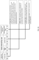
- region codes will be allocated to each "major administrative area.” As a representative example, the North America group (USA, Canada, and Mexico) region codes will be allocated to:
- the second list contains the L2ADs and their corresponding populations if the L2AD population is greater than 1,800,000.
- the L2AD's on the second list are considered to be large L2ADs (LL2ADs).
- SL2ADs in the first list proceed on to Step 5 on Figure 4A .
- Step 5 the SL2ADs are displayed on a map.
- the map will graphically represent each L2AD and will be annotated with each L2AD population.
- Step 6 the largest (by population) unprocessed SL2AD is selected.
- the SL2ADs that have not been selected for processing via the procedure described in Step 6 are considered to be unprocessed and are identified as such.
- the SL2AD selected to be processed will be referred to as the target L2AD and be included in a group referred to as the target group in subsequent processing steps.
- Step 7 if there is at least one SL2AD contiguous to the target, each SL2AD contiguous to the target is listed and sorted by population largest to smallest. The list of SL2ADs contiguous to the target L2AD is reviewed and sorted, largest to smallest, to facilitate the determination of whether contiguous SL2AD can be added to the target L2AD's population and not exceed a population of 1,800,000.
- Step 8 if there is a contiguous SL2AD whose population may be added to the target L2AD's population and not exceed 1,800,000 then that contiguous SL2AD is grouped with the target L2AD and this new group becomes the target group, now consisting of two L2ADs.
- Step 9 the result of Step 7 is negative, therefore proceed to Step 10.
- SL2AD the largest SL2AD in the target group.
- local authorities assign codes (names) to geographic areas within their borders; depending upon the size of the geographic area these codes identify L2ADs or L3ADs. For simplicity, these assigned codes may be assigned to the SL2ADs and a numeric suffix (e.g. ".99") may be appended to the assigned code. For example: if code is ABCD then new code will be ABCD.99. This new code is the canton code for the SL2AD. This same code may also be assigned to all of the SL2ADs in the target group.
- Step 11 all SL2ADs included in the target are considered to have been processed and are identified as such.
- Step 12 if there are still unprocessed SL2ADs then Step 6 is repeated.
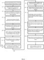
- any LL2ADs will be assigned to sub-list B and processed as shown in Step 14 of Figure4B .
- Step 14 the largest unprocessed LL2AD will be selected. This LL2AD will be referred to as the target in the following steps.
- Step 15 the target LL2AD is processed.
- all LL2AD in sub-list B have a population greater than about 1.8 million, each LL2ADs must be sub-divided into parts, each part with a maximum population less than about 1.8 million.
- division will be along divisions previously created by local authorities such as US Census Bureau, Statistics Canada, UK Office of National Statistics, Stat Vietnameses Bureauamt Kunststoff, etc.
- the sub-groups used for division of L2ADs with a population greater than 1.8 million be composed of contiguous L3ADs and that the populations of the sub-groups be as equal as possible.
- Step 18 a check is made to see if there are any LL2ADs still to be processed. If there are unprocessed LL2ADs, return to Step 14. If there are no remaining unprocessed LL2ADs, proceed to Step 19
- .Once cantons have been created for all areas of a geographical group (e.g. North America) , and canton codes assigned, a region codes must be assigned to each canton. This can be done by randomly assigning the available permutations of the two character region code. However, in the preferred embodiments the region code assigned to a canton will have a pneumonic significance if possible.
- a canton comprising the two counties of Buffalo and Smith in New York State may be assigned a region code of BU, as a shortened version of Buffalo.
- the assigning of a region codes to cantons in the preferred embodiments is preferably performed manually, which allows for a human to make judgments about the region code to be assigned.
- Region codes are assigned to each address in the address list by merging a region code database with the address list database or by using a "lookup" database command. Doing this is a well know procedure for anyone skilled in the art.
- each address in the address list will have had a region code assigned to it. All addresses located within the same canton will have the same region code. Each canton will be assigned a unique region code.
- .It is from this list that a location code will be assigned to each address within each region code.
- each region code will have its own location code base list.
- the location code will be marked as "assigned" to prevent the same location code being used more than once within a particular canton.
- the address list used by a satnav device contains at a minimum of these fields for each address: address components (the human understandable portions of the address, e.g. 100 Main Street, Anytown, New York), and the latitude and longitude of the address or information that is sufficient to compute an approximate latitude and longitude for the address. Example: for a particular road there may be no information as to where on that road an address is located. Typically then, the satnav device calculates the mid-point of the road, determines the latitude and longitude of this mid-point and gives this latitude/longitude pair to the satnav software for processing and determining directions to that point.
- address components the human understandable portions of the address, e.g. 100 Main Street, Anytown, New York
- latitude and longitude of the address or information that is sufficient to compute an approximate latitude and longitude for the address.
- the satnav device calculates the mid-point of the road, determines the latitude and longitude of this mid-point and gives this latitude/long
- the address components are what will be typically entered by the user.
- the satnav device will perform a lookup on its database and return the latitude and longitude of the address.
- the satnav device will then calculate a path from the latitude and longitude of where the satnav is currently located to the latitude and longitude of the desired location.
- Step 21 the addresses in the address list for that geographical group are sorted by region code.
- Step 26 a first group of pre-sorted addresses is selected such that all addresses with the same region code are selected.
- Step 27 each address is assigned a location code from the location code base list for that region code. This process can be easily done by one skilled in the art.
- Steps 28 and 29 the location code assigned in Step 27 is provided the designation "assigned” so that it will not be reused within the current group and the associated address record is provided the designation "processed” so that it will not be reassigned a new location code.
- X is the truncated portion of X(Bar); if the decimal fraction portion of X(Bar) is greater than 0.3, X is rounded up to the next integer.
- Step 37 the process detailed in Figures 3 , 4A and 4B is used to group all L2AD in the group into cantons.
- the L2AD must be divided into "sub-L2ADs" preferably using boundaries established and maintained by the local government. These sub-L2ADs will then be treated as L2ADs. Appropriate notations will be made in database.
- each sub-group may be divided into 32 cantons.
- a canton is comprised of a group of L2ADs and/or subdivisions of a L2AD.
- Each canton preferably should have a maximum population of approximately 1,800,000.
- Cantons in sub-group B will be labeled B01, B02, B03, and so forth up to B32, the 32nd canton.
- the characters 1, I, 0, O will be skipped when labeling cantons to reduce errors in transcription and reading.
- the last canton of the last sub-group is labeled J32.
- Step 40 a check is made to see if the maximum allowable population (approximately 57 million) has been reached. If not, then Step 39 is repeated. If maximum population has been reached or exceeded then proceed to Step 41.
- the processing software would automatically determine which type of code was entered by the user. This is accomplished by reserving certain code characters for special applications, thus allowing the software to automatically determine which type of code was entered and then select the appropriate database to use.
- the last (fourth) character of the location code may be limited to the letters of the alphabet, excluding I and O and with no numbers used. This reduces the number of permutations available for the location code and thus the maximum population of the L2ADs that are grouped into cantons. The maximum population of each canton would be 1.3 million instead of the 1.8 million used in the standard 6 character embodiment. This change has no material effect on the processes that have been described for the implementation of the 6 character embodiment.
- the software may also identify the number of characters entered to determine if the code entered is a special code or a standard code.
- the standard code is 6 characters long. All special codes are also 6 characters long with the exception of the personalized codes which can be from 4 to 8 characters.
- the QCODE geotagging method typically geocode a location by using an algorithm to shorten the latitude/longitude of the location or the coordinates of the location on a grid map system. This results in a geotag that can be something like AB2-2SDF or A23-56GH. With the QCODE geotagging method the geotag can be chosen to have a "link" to the group of locations being geocoded. As an example, all QCODE geotags for McDonald's restaurants begin with "MD” or "MAC” or “MCD.” This is of an obvious benefit to the corporate customer and to the user.
- the device may be programmed to display the site code from the closest site and ask the user to confirm that they want to use the suggested site code.
- the region code "SU" would also, most probably, be assigned to a canton elsewhere in the North America group.
- the satnav device may be easily programmed to make a logical choice of which set of geotags to use. The user could be asked to confirm the choice made by the software.
- Site coding could also allow workers at a particular municipality or company to use relatively inexpensive satnav devices (either a smartphone or a stand-alone satnav system such as those made by Garmin and TomTom) to locate particular items of interest.
- relatively inexpensive satnav devices either a smartphone or a stand-alone satnav system such as those made by Garmin and TomTom
- Site coding would also allow a maintenance system to have a coding system to uniquely identify each item requiring maintenance.
- the present invention provides a more elegant and efficient way to identify these locations.
- Site coding may also be used with "indoor mapping" applications to assign individual geotags to specific indoor locations such as stores within a large shopping mall or airline counters within an airport.
- the QCODE geotagging method may be used to provide individualized codes to individual persons or businesses. Much like many states in the US allow motorists to have individualized license plates, the QCODE geotagging method may do this a well. These individualized codes may be sold to individual persons or businesses.
- the satnav device can be calculating the distance to the next closest "JOHN SMITH” locations. If user selects "No, show me more addresses,” then the next closest "JOHN SMITH” locations can be displayed, in order of their distance, closest first.
- a satnav device would seem to be ideal for this however in many cases the location of the outlet does not have a normal or useful postal address. They may be located in a large shopping center, or other places where the mailing address for the outlet may not be close to the physical location of the actual outlet.
- all corporate geotags will end in either the numeral six or seven. This will enable, for example, the region code MD to be used in the standard QCODE geotagging process system, as well as for McDonald's (MD-XXX6).
- the standard code with a region code of "MD” will not end in a number.
- the McDonald's corporate codes will end in either a six or a seven and therefore are easily distinguished by the processing software.
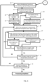
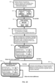
- Step 47 the satnav device is turned on.
- the device goes through its normal start-up routine, obtains fixes on GPS satellites and determines its location (latitude and longitude).
- the satnav device determines it is located in North America. Therefore it will use the North America group database of QCODE geotags.
- Step 48 the user is presented with a screen. User chooses to use a QCODE geotag to input the details of his desired destination.
- Step 49 user is presented with screen where they enter the QCODE code of the desired destination.
- Step 50 processing software of the satnav devices checks the code: does the code entered have the correct number of characters, and check for invalid characters.
- Step 51 the code has been looked up in a database (the North America database in this example) and the latitude/longitude pair plus the address are retrieved from the database.
- a database the North America database in this example
- Step 52 the address associated with the code is presented to the user to confirm that it is correct. If address is correct user selects "Correct, take me there" button. Satnav device then proceeds to give direction to the address as if it had been entered manually. This is a process well known to those skilled in the art.
- Step 54 the user is presented with a screen. User chooses to use a QCODE code to select his desired destination.
- these results are sorted by distance from the user, nearest address first, furthest address last.
- Step 59 the next two (in distance) addresses are presented to the user. This process is repeated until the desire location is presented and the user selects the "Go Here" button.
- Step 60 the latitude and longitude of the selected location is passed on to the software of the satnav device.
- the satnav device then follows its normal process to provide directions to the desired location.
- the screen shown in Step 6 may show more than 2 addresses which means that the likelihood that the desired location is presented during the first presentation would be increased even further.
- One of the factors that may determine the number of addresses presented at one time would be the size of the screen and the size of the font used to present the information.
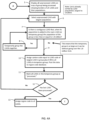
- a code has been entered into the satnav device by the user.
- the software must determine which type of special code the entered code is and then use the appropriate database to retrieve the latitude/longitude pair associated with that code and then calculate directions to the desired location.
- Step 65 if the sixth character is a 6 or a 7 then the code is determined to be a corporate code.
- the corporate code is looked up in the corporate code database and the process of Step 64 is followed.
- Step 70 the necessary information for the location chosen by the user is passed on to the normal satnav software.
- the satnav software then calculates the best path to the destination.
- Step 61 If the code entered in Step 61 has 4, 5, 7, or 8 characters, then it is identified as a personal code.
- Step 72 the name and address information for the corresponding address is presented to the user for confirmation.
- Step 73 after user has confirmed which address he wants, the appropriate information is passed to the standard satnav device software. The software then calculates the appropriate directions to the desired destination.
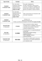
- FIG. 12 showing examples of how QCODE geocode may be displayed.
- the geocodes are shown in bold type only as an aid to the reader. These examples do not limit in any way the various ways that geocodes can be displayed in actual use.
- the example of a site codes shows how the same code can be used for two different locations. The satnav device knows which location is the desired one based on the location of the device at the time the code is entered into the satnav device.
Landscapes
- Engineering & Computer Science (AREA)
- Remote Sensing (AREA)
- Radar, Positioning & Navigation (AREA)
- General Physics & Mathematics (AREA)
- Physics & Mathematics (AREA)
- Databases & Information Systems (AREA)
- Theoretical Computer Science (AREA)
- Automation & Control Theory (AREA)
- Data Mining & Analysis (AREA)
- General Engineering & Computer Science (AREA)
- Health & Medical Sciences (AREA)
- General Health & Medical Sciences (AREA)
- Social Psychology (AREA)
- Navigation (AREA)
- Information Retrieval, Db Structures And Fs Structures Therefor (AREA)
Claims (13)
- Procédé de codage d'emplacements géographiques associé à un objet désiré quel que soit l'endroit, le procédé comprenant les étapes suivantes :attribution systématique d'un code à un emplacement géographique comprenant une adresse ou un point d'intérêt, le code comprenant un code principal et un code auxiliaire, dans lequel ledit code principal comprend un code de région et un code d'emplacement et ledit code auxiliaire comprend un code de groupe identifiant un groupe de pays et un code d'emplacement étendu ; ledit code de groupe dudit code auxiliaire est un code alphabétique à trois caractères, dans lequel les pays sont affectés à un groupe de manière logique sur la base de l'utilisation probable d'un appareil de navigation par satellite dans cette zone, ledit code de région est un code alphanumérique unique à un ou deux caractères pour un groupement de divisions administratives de deuxième niveau contiguës, ledit code d'emplacement est un code alphanumérique unique à quatre caractères attribué à une adresse ou à un point d'intérêt dans une région comprenant ledit groupement de divisions administratives de deuxième niveau contiguës ; et le code d'emplacement étendu est un code alphanumérique à quatre caractères qui permet une expansion future si cela s'avère nécessaire ou souhaité ;dans lequel l'emplacement géographique comprenant une adresse ou un point d'intérêt est identifié par une paire latitude-longitude ;ledit code attribué et la paire latitude-longitude pour ladite adresse ou ledit point d'intérêt sont stockés dans une base de données pour le groupe, dans lequel ladite adresse ou ledit point d'intérêt est situé ;ladite base de données est stockée à distance sur un serveur ou localement sur un appareil de navigation par satellite d'un système de navigation par satellite ;dans lequel, afin d'identifier l'emplacement géographique d'une adresse ou d'un point d'intérêt souhaité, seul le code principal du code attribué à cette adresse ou à ce point d'intérêt est saisi par un utilisateur sur ledit dispositif de navigation par satellite, dans lequel la longueur combinée du code principal est de cinq ou six caractères sélectionnés dans un jeu de caractères de base ;dans lequel l'appareil de navigation par satellite détermine le groupe dans lequel il se trouve pour accéder à la base de données du groupe et utilise le code de base saisi pour effectuer une recherche dans ladite base de données afin de renvoyer la paire latitude-longitude à l'appareil de navigation par satellite pour l'emplacement géographique comprenant ladite adresse ou ledit point d'intérêt ; etdirection de l'utilisateur vers l'adresse ou le point d'intérêt souhaités.
- Procédé selon la revendication 1, dans lequel l'emplacement géographique comprend une adresse civique.
- Procédé selon la revendication 1, dans lequel l'emplacement géographique n'a pas d'adresse civique spécifique.
- Procédé selon la revendication 1, dans lequel le quatrième caractère du code d'emplacement consiste en un membre du jeu de caractères alphabétiques, à l'exception de I et O, ou le quatrième caractère consiste en un caractère numérique spécifique, ledit caractère numérique spécifique identifiant le code comme un code d'entreprise pour une entreprise cliente.
- Procédé selon la revendication 1 ou la revendication 4, dans lequel le code de région est spécifique à une entreprise cliente, notamment acheté par l'entreprise cliente ou est spécifique à un emplacement particulier.
- Procédé selon la revendication 1, dans lequel le code de région et le code d'emplacement combinés sont spécifiques à un individu particulier.
- Procédé selon la revendication 1, dans lequel le code attribué à un emplacement géographique comprend un jeu de 32 caractères de base comprenant le jeu de caractères alphabétiques, à l'exception de I et O, et le jeu de caractères numériques, à l'exception de 0 et 1.
- Procédé selon la revendication 7, dans lequel les codes de région et les codes d'emplacement combinés sont attribués de manière aléatoire.
- Procédé selon la revendication 7, dans lequel les codes de région sont attribués de manière systématique afin de minimiser la quantité requise de codes de région pour un ensemble particulier d'emplacements géographiques, ou les codes d'emplacement sont attribués de manière systématique aux seuls emplacements qui contiennent une adresse réelle ou un point d'intérêt afin de minimiser la quantité requise de codes d'emplacement pour un ensemble particulier d'emplacements géographiques.
- Procédé selon la revendication 1, dans lequel le code attribué à un emplacement géographique comprend un jeu de 36 caractères de base comprenant le jeu de caractères alphabétiques et le jeu de caractères numériques.
- Procédé selon l'une quelconque des revendications 7 à 10, dans lequel le code attribué comprend un autre jeu de caractères.
- Procédé selon la revendication 11, dans lequel le code attribué comprend des symboles, ou des caractères de l'alphabet cyrillique et du jeu de caractères numériques, ou des caractères du jeu de caractères cantonais et du jeu de caractères numériques.
- Système de navigation pour générer des informations de routage, le système de navigation comprenant :un dispositif de navigation par satellite comprenant un processeur, un écran utilisateur, un code logiciel, ledit code logiciel étant programmé pour faire fonctionner le dispositif de navigation par satellite, un dispositif d'entrée utilisateur, une ROM, une RAM, une alimentation électrique, un récepteur GPS et une antenne GPS ; etun réseau de satellites GPS ; ledit récepteur GPS recevant des informations d'emplacement du réseau de satellites GPS par l'intermédiaire de l'antenne GPS ; etune base de données, ladite base de données étant stockée localement sur ledit dispositif de navigation par satellite ou stockée à distance sur un serveur, ladite base de données comprenant une liste d'emplacements géographiques comprenant des paires latitude-longitude pour les adresses ou les points d'intérêt et une liste de codes attribués auxdites adresses ou auxdits points d'intérêt et dans laquelle chaque code dans ladite liste de codes comprend un code principal et un code auxiliaire, ledit code principal comprenant un code de région et un code d'emplacement et ledit code auxiliaire comprenant un code de groupe identifiant un groupe de pays et un code d'emplacement étendu ;dans lequel ledit code de groupe dudit code auxiliaire comprend un code alphabétique à trois caractères dans lequel les pays sont affectés à un groupe de manière logique sur la base de l'utilisation probable d'un appareil de navigation par satellite dans cette zone, ledit code de région comprend un code alphanumérique unique à un ou deux caractères pour un groupement de divisions administratives de deuxième niveau contiguës, ledit code d'emplacement comprend un code alphanumérique unique à quatre caractères affecté à chaque adresse ou point d'intérêt dans une région comprenant ledit groupement de divisions administratives de deuxième niveau contiguës ; et le code d'emplacement étendu comprend un code alphanumérique à quatre caractères qui permet une expansion future si cela est nécessaire ou souhaité ;la base de données stockant un code attribué et une paire latitude-longitude pour une adresse ou un point d'intérêt pour le groupe dans lequel cette adresse ou ce point d'intérêt est situé ;dans lequel ledit code logiciel programmé pour faire fonctionner l'appareil de navigation par satellite configure ledit dispositif de navigation pour mettre en œuvre le procédé comprenant les étapes suivantes :réception d'un utilisateur, en tant qu'entrée, uniquement du code principal d'un code attribué pour une adresse souhaitée ou un point d'intérêt, la longueur combinée du code principal étant de cinq ou six caractères sélectionnés dans un jeu de caractères de base ;détermination du groupe dans lequel se trouve le dispositif de navigation par satellite afin d'accéder à la base de données pour le groupe ;utilisation du code de base saisi pour effectuer une recherche dans ladite base de données afin de renvoyer la paire latitude-longitude pour l'emplacement géographique comprenant ladite adresse ou ledit point d'intérêt souhaités ; etdirection de l'utilisateur vers l'adresse ou le point d'intérêt souhaités.
Applications Claiming Priority (3)
| Application Number | Priority Date | Filing Date | Title |
|---|---|---|---|
| US201261736539P | 2012-12-12 | 2012-12-12 | |
| US201361754157P | 2013-01-18 | 2013-01-18 | |
| PCT/US2013/074234 WO2014093413A1 (fr) | 2012-12-12 | 2013-12-11 | Système de codage pour système de navigation par satellite |
Publications (4)
| Publication Number | Publication Date |
|---|---|
| EP2932193A1 EP2932193A1 (fr) | 2015-10-21 |
| EP2932193A4 EP2932193A4 (fr) | 2016-07-27 |
| EP2932193C0 EP2932193C0 (fr) | 2025-04-09 |
| EP2932193B1 true EP2932193B1 (fr) | 2025-04-09 |
Family
ID=50934909
Family Applications (1)
| Application Number | Title | Priority Date | Filing Date |
|---|---|---|---|
| EP13862907.6A Active EP2932193B1 (fr) | 2012-12-12 | 2013-12-11 | Système de codage pour système de navigation par satellite |
Country Status (3)
| Country | Link |
|---|---|
| US (2) | US9952052B2 (fr) |
| EP (1) | EP2932193B1 (fr) |
| WO (1) | WO2014093413A1 (fr) |
Families Citing this family (7)
| Publication number | Priority date | Publication date | Assignee | Title |
|---|---|---|---|---|
| CN105203120B (zh) * | 2014-06-30 | 2018-12-07 | 腾讯科技(深圳)有限公司 | 导航路线评测方法及装置 |
| WO2018150244A1 (fr) * | 2017-02-18 | 2018-08-23 | Yogesh Chunilal Rathod | Enregistrement et auto-génération d'un ou de plusieurs mots uniques, et accès à celui-ci ou à ceux-ci, ledit ou lesdits mots uniques comprenant des géomarques uniques |
| CN107169893A (zh) * | 2017-04-28 | 2017-09-15 | 深圳市数字城市工程研究中心 | 一种基于垂直方向上空间剖分细化的地籍产权体编码方法 |
| CN111457932B (zh) * | 2019-01-21 | 2024-03-08 | 阿里巴巴集团控股有限公司 | 兴趣点识别方法、装置及导航方法及系统、设备 |
| KR20220007300A (ko) * | 2020-07-10 | 2022-01-18 | 에스케이하이닉스 주식회사 | 메모리 시스템 및 메모리 시스템의 동작방법 |
| US11502908B1 (en) * | 2021-06-02 | 2022-11-15 | Zscaler, Inc. | Geo tagging for advanced analytics and policy enforcement on remote devices |
| CN117271693B (zh) * | 2023-10-17 | 2024-04-26 | 中运科技股份有限公司 | 基于大数据分析的交通线路到站归属地自动判定方法 |
Family Cites Families (29)
| Publication number | Priority date | Publication date | Assignee | Title |
|---|---|---|---|---|
| US5839088A (en) * | 1996-08-22 | 1998-11-17 | Go2 Software, Inc. | Geographic location referencing system and method |
| US20040139049A1 (en) * | 1996-08-22 | 2004-07-15 | Wgrs Licensing Company, Llc | Unified geographic database and method of creating, maintaining and using the same |
| US6101496A (en) * | 1998-06-08 | 2000-08-08 | Mapinfo Corporation | Ordered information geocoding method and apparatus |
| US6732120B1 (en) * | 1998-09-03 | 2004-05-04 | Geojet Information Solutions Inc. | System and method for processing and display of geographical data |
| US6549672B1 (en) * | 1999-06-29 | 2003-04-15 | Sony Corporation | Method and apparatus for recovery of encoded data using central value |
| WO2002097726A1 (fr) * | 2001-05-31 | 2002-12-05 | Mapinfo Corporation | Systeme et procede de geocodage de structures d'adresses diverses |
| JP2003075167A (ja) * | 2001-09-04 | 2003-03-12 | Sony Corp | ナビゲーション装置、地図の表示方法および画像表示装置 |
| US7324666B2 (en) * | 2002-11-15 | 2008-01-29 | Whitegold Solutions, Inc. | Methods for assigning geocodes to street addressable entities |
| JP4384118B2 (ja) * | 2003-06-27 | 2009-12-16 | 徹 西岡 | 座標相互変換モジュール |
| US7873663B2 (en) * | 2004-01-13 | 2011-01-18 | International Business Machines Corporation | Methods and apparatus for converting a representation of XML and other markup language data to a data structure format |
| EP1779062A1 (fr) * | 2004-07-17 | 2007-05-02 | Shahriar Sarkeshik | Codes de localisation pour acheminement a destination |
| US7630724B2 (en) * | 2004-09-21 | 2009-12-08 | Advanced Ground Information Systems, Inc. | Method of providing a cellular phone/PDA communication system |
| US7627545B2 (en) * | 2005-02-02 | 2009-12-01 | At&T Intellectual Property Ii, Lp. | Geocoding method using multidimensional vector spaces |
| KR100663405B1 (ko) | 2005-06-03 | 2007-01-02 | 엘지전자 주식회사 | 국가간 이동경로 자동 탐색 방법 및 장치 |
| JP3885157B2 (ja) * | 2005-08-02 | 2007-02-21 | 直生 上田 | 地理的座標変換方法、装置、プログラム、ならびに地理的座標コードを記した情報担持体および地図 |
| US7779059B2 (en) * | 2005-12-22 | 2010-08-17 | Pitney Bowes Software Inc. | Geocoding and address hygiene system employing point level and centerline data sets |
| KR20070091472A (ko) * | 2006-03-06 | 2007-09-11 | 주식회사 현대오토넷 | 네비게이션의 인덱스 데이터를 이용한 지역 변경방법 |
| US7539573B2 (en) * | 2006-06-23 | 2009-05-26 | Pitney Bowes Software Inc. | Enhanced positional accuracy in geocoding by dynamic interpolation |
| US8869066B2 (en) * | 2006-07-06 | 2014-10-21 | Addthis, Llc | Generic content collection systems |
| US8198980B1 (en) | 2007-09-21 | 2012-06-12 | Luger Dale J | Numeric geodesic locator |
| US20100325143A1 (en) * | 2007-11-13 | 2010-12-23 | Route 66 Switzerland Gmbh | Automatically linking geographic terms to geographic information |
| US20090140887A1 (en) * | 2007-11-29 | 2009-06-04 | Breed David S | Mapping Techniques Using Probe Vehicles |
| WO2011073965A1 (fr) * | 2009-12-16 | 2011-06-23 | Loc8 Code Limited | Procédé de navigation utilisant des codes de localisation géographique |
| US8271510B2 (en) * | 2009-12-28 | 2012-09-18 | Verizon Patent And Licensing Inc. | Translating and geocoding addresses |
| US20110208427A1 (en) | 2010-02-25 | 2011-08-25 | Peter S. Brennan | Location Identification Systems and Methods |
| US8650024B1 (en) * | 2011-04-13 | 2014-02-11 | Google Inc. | Generating address term synonyms |
| CN102737060B (zh) * | 2011-04-14 | 2017-09-12 | 商业对象软件有限公司 | 地理编码应用中的模糊搜索 |
| GB201117901D0 (en) * | 2011-10-18 | 2011-11-30 | Tomtom Int Bv | Map code: a public location encoding standard |
| US9264857B1 (en) * | 2013-10-15 | 2016-02-16 | Google Inc. | Compact codes for geographic locations |
-
2013
- 2013-12-11 EP EP13862907.6A patent/EP2932193B1/fr active Active
- 2013-12-11 WO PCT/US2013/074234 patent/WO2014093413A1/fr not_active Ceased
- 2013-12-11 US US14/651,110 patent/US9952052B2/en active Active
-
2018
- 2018-03-12 US US15/918,402 patent/US10718621B2/en active Active
Also Published As
| Publication number | Publication date |
|---|---|
| WO2014093413A1 (fr) | 2014-06-19 |
| EP2932193C0 (fr) | 2025-04-09 |
| US10718621B2 (en) | 2020-07-21 |
| EP2932193A4 (fr) | 2016-07-27 |
| US20150308840A1 (en) | 2015-10-29 |
| US9952052B2 (en) | 2018-04-24 |
| US20180202817A1 (en) | 2018-07-19 |
| EP2932193A1 (fr) | 2015-10-21 |
Similar Documents
| Publication | Publication Date | Title |
|---|---|---|
| US10718621B2 (en) | System for producing compact location codes | |
| US11372903B2 (en) | Systems and methods for providing mapping information | |
| US8996523B1 (en) | Forming quality street addresses from multiple providers | |
| US7092817B2 (en) | Map information retrieving | |
| RU2008148959A (ru) | Каталоги местностей и способ составления каталогов местностей | |
| JP6203773B2 (ja) | 位置コンテンツ管理システムにおいて線形構造部を表現する方法 | |
| US20110208427A1 (en) | Location Identification Systems and Methods | |
| US8341192B2 (en) | Navigation system and methods regarding disputed territories | |
| WO2015166352A2 (fr) | Techniques de codage d'adresse et de séquençage d'impression synchronisés | |
| US8996307B2 (en) | Navigation system and methods regarding disputed territories | |
| US20100222996A1 (en) | Dual Representation of an Address in a Database | |
| JP2018156377A (ja) | 情報出力装置、情報生成装置、情報出力方法及び情報生成方法 | |
| de Armas García et al. | Deployment of a National Geocoding Service: Cuban Experience. | |
| EP2295936B1 (fr) | Système de navigation et procédés liés à des territoires contestés | |
| JP2008165096A (ja) | 位置情報算出方法およびプログラム | |
| US20160125031A1 (en) | Method and apparatus for retrieving and organizing physical addresses | |
| CN101017095A (zh) | 通过输入代码以找出相对应的电子地图的导航系统及方法 | |
| KR102000683B1 (ko) | 격자와 단어조합을 이용한 위치표시장치 | |
| Rwerekane et al. | Natural area coding based postcode scheme | |
| JP2007292566A (ja) | 天気予報表示システム | |
| Mazur et al. | An interactive map of the main bus station in Lublin–travel information system based on geospatial data sources | |
| DiBiase | TIGER, Topology and Geocoding | |
| KR20150046021A (ko) | 지리적 주소의 간이화된 표현을 위한 시스템 및 방법 | |
| Othman et al. | Conceptual Design of Malaysia Geopostcode System | |
| TW200539066A (en) | Method for converting geological spaces |
Legal Events
| Date | Code | Title | Description |
|---|---|---|---|
| PUAI | Public reference made under article 153(3) epc to a published international application that has entered the european phase |
Free format text: ORIGINAL CODE: 0009012 |
|
| 17P | Request for examination filed |
Effective date: 20150525 |
|
| AK | Designated contracting states |
Kind code of ref document: A1 Designated state(s): AL AT BE BG CH CY CZ DE DK EE ES FI FR GB GR HR HU IE IS IT LI LT LU LV MC MK MT NL NO PL PT RO RS SE SI SK SM TR |
|
| AX | Request for extension of the european patent |
Extension state: BA ME |
|
| DAX | Request for extension of the european patent (deleted) | ||
| A4 | Supplementary search report drawn up and despatched |
Effective date: 20160627 |
|
| RIC1 | Information provided on ipc code assigned before grant |
Ipc: G01S 19/38 20100101ALI20160621BHEP Ipc: G06F 17/30 20060101ALI20160621BHEP Ipc: G01C 21/32 20060101ALI20160621BHEP Ipc: G01C 21/00 20060101AFI20160621BHEP Ipc: G01C 21/36 20060101ALI20160621BHEP |
|
| STAA | Information on the status of an ep patent application or granted ep patent |
Free format text: STATUS: EXAMINATION IS IN PROGRESS |
|
| 17Q | First examination report despatched |
Effective date: 20190208 |
|
| REG | Reference to a national code |
Ref country code: DE Ref legal event code: R079 Free format text: PREVIOUS MAIN CLASS: G01C0021000000 Ipc: G01C0021360000 Ref country code: DE Ref legal event code: R079 Ref document number: 602013086661 Country of ref document: DE Free format text: PREVIOUS MAIN CLASS: G01C0021000000 Ipc: G01C0021360000 |
|
| GRAP | Despatch of communication of intention to grant a patent |
Free format text: ORIGINAL CODE: EPIDOSNIGR1 |
|
| STAA | Information on the status of an ep patent application or granted ep patent |
Free format text: STATUS: GRANT OF PATENT IS INTENDED |
|
| RIC1 | Information provided on ipc code assigned before grant |
Ipc: G06F 16/29 20190101ALI20241111BHEP Ipc: G01C 21/36 20060101AFI20241111BHEP |
|
| INTG | Intention to grant announced |
Effective date: 20241129 |
|
| GRAS | Grant fee paid |
Free format text: ORIGINAL CODE: EPIDOSNIGR3 |
|
| GRAA | (expected) grant |
Free format text: ORIGINAL CODE: 0009210 |
|
| STAA | Information on the status of an ep patent application or granted ep patent |
Free format text: STATUS: THE PATENT HAS BEEN GRANTED |
|
| RAP1 | Party data changed (applicant data changed or rights of an application transferred) |
Owner name: HALE, MATHILDE ELEONORE Owner name: HALE, MEGHANN ROSE Owner name: HALE, ELISE SARAH Owner name: HALE, MERTON G. |
|
| RIN1 | Information on inventor provided before grant (corrected) |
Inventor name: HALE, MATHILDE ELEONORE Inventor name: HALE, MEGHANN ROSE Inventor name: HALE, ELISE SARAH Inventor name: HALE, MERTON G. |
|
| AK | Designated contracting states |
Kind code of ref document: B1 Designated state(s): AL AT BE BG CH CY CZ DE DK EE ES FI FR GB GR HR HU IE IS IT LI LT LU LV MC MK MT NL NO PL PT RO RS SE SI SK SM TR |
|
| RAP1 | Party data changed (applicant data changed or rights of an application transferred) |
Owner name: HALE, MATHILDE ELEONORE Owner name: HALE, MEGHANN ROSE Owner name: HALE, ELISE SARAH |
|
| REG | Reference to a national code |
Ref country code: GB Ref legal event code: FG4D |
|
| RIN1 | Information on inventor provided before grant (corrected) |
Inventor name: HALE, MATHILDE ELEONORE Inventor name: HALE, MEGHANN ROSE Inventor name: HALE, ELISE SARAH |
|
| REG | Reference to a national code |
Ref country code: CH Ref legal event code: EP |
|
| REG | Reference to a national code |
Ref country code: IE Ref legal event code: FG4D |
|
| U01 | Request for unitary effect filed |
Effective date: 20250409 |
|
| U07 | Unitary effect registered |
Designated state(s): AT BE BG DE DK EE FI FR IT LT LU LV MT NL PT RO SE SI Effective date: 20250415 |
|
| PG25 | Lapsed in a contracting state [announced via postgrant information from national office to epo] |
Ref country code: ES Free format text: LAPSE BECAUSE OF FAILURE TO SUBMIT A TRANSLATION OF THE DESCRIPTION OR TO PAY THE FEE WITHIN THE PRESCRIBED TIME-LIMIT Effective date: 20250409 |
|
| PG25 | Lapsed in a contracting state [announced via postgrant information from national office to epo] |
Ref country code: GR Free format text: LAPSE BECAUSE OF FAILURE TO SUBMIT A TRANSLATION OF THE DESCRIPTION OR TO PAY THE FEE WITHIN THE PRESCRIBED TIME-LIMIT Effective date: 20250710 Ref country code: NO Free format text: LAPSE BECAUSE OF FAILURE TO SUBMIT A TRANSLATION OF THE DESCRIPTION OR TO PAY THE FEE WITHIN THE PRESCRIBED TIME-LIMIT Effective date: 20250709 |
|
| PG25 | Lapsed in a contracting state [announced via postgrant information from national office to epo] |
Ref country code: PL Free format text: LAPSE BECAUSE OF FAILURE TO SUBMIT A TRANSLATION OF THE DESCRIPTION OR TO PAY THE FEE WITHIN THE PRESCRIBED TIME-LIMIT Effective date: 20250409 |
|
| PG25 | Lapsed in a contracting state [announced via postgrant information from national office to epo] |
Ref country code: HR Free format text: LAPSE BECAUSE OF FAILURE TO SUBMIT A TRANSLATION OF THE DESCRIPTION OR TO PAY THE FEE WITHIN THE PRESCRIBED TIME-LIMIT Effective date: 20250409 |
|
| PG25 | Lapsed in a contracting state [announced via postgrant information from national office to epo] |
Ref country code: RS Free format text: LAPSE BECAUSE OF FAILURE TO SUBMIT A TRANSLATION OF THE DESCRIPTION OR TO PAY THE FEE WITHIN THE PRESCRIBED TIME-LIMIT Effective date: 20250709 |
|
| PG25 | Lapsed in a contracting state [announced via postgrant information from national office to epo] |
Ref country code: IS Free format text: LAPSE BECAUSE OF FAILURE TO SUBMIT A TRANSLATION OF THE DESCRIPTION OR TO PAY THE FEE WITHIN THE PRESCRIBED TIME-LIMIT Effective date: 20250809 |
|
| U20 | Renewal fee for the european patent with unitary effect paid |
Year of fee payment: 13 Effective date: 20251107 |
|
| REG | Reference to a national code |
Ref country code: CH Ref legal event code: U11 Free format text: ST27 STATUS EVENT CODE: U-0-0-U10-U11 (AS PROVIDED BY THE NATIONAL OFFICE) Effective date: 20260101 |
|
| PGFP | Annual fee paid to national office [announced via postgrant information from national office to epo] |
Ref country code: GB Payment date: 20251107 Year of fee payment: 13 |
|
| PG25 | Lapsed in a contracting state [announced via postgrant information from national office to epo] |
Ref country code: SM Free format text: LAPSE BECAUSE OF FAILURE TO SUBMIT A TRANSLATION OF THE DESCRIPTION OR TO PAY THE FEE WITHIN THE PRESCRIBED TIME-LIMIT Effective date: 20250409 |
|
| PG25 | Lapsed in a contracting state [announced via postgrant information from national office to epo] |
Ref country code: CZ Free format text: LAPSE BECAUSE OF FAILURE TO SUBMIT A TRANSLATION OF THE DESCRIPTION OR TO PAY THE FEE WITHIN THE PRESCRIBED TIME-LIMIT Effective date: 20250409 |
|
| PGFP | Annual fee paid to national office [announced via postgrant information from national office to epo] |
Ref country code: IE Payment date: 20251107 Year of fee payment: 13 |
|
| PG25 | Lapsed in a contracting state [announced via postgrant information from national office to epo] |
Ref country code: SK Free format text: LAPSE BECAUSE OF FAILURE TO SUBMIT A TRANSLATION OF THE DESCRIPTION OR TO PAY THE FEE WITHIN THE PRESCRIBED TIME-LIMIT Effective date: 20250409 |
|
| PLBE | No opposition filed within time limit |
Free format text: ORIGINAL CODE: 0009261 |
|
| STAA | Information on the status of an ep patent application or granted ep patent |
Free format text: STATUS: NO OPPOSITION FILED WITHIN TIME LIMIT |
|
| REG | Reference to a national code |
Ref country code: CH Ref legal event code: L10 Free format text: ST27 STATUS EVENT CODE: U-0-0-L10-L00 (AS PROVIDED BY THE NATIONAL OFFICE) Effective date: 20260218 |
|
| 26N | No opposition filed |
Effective date: 20260112 |
|
| PGFP | Annual fee paid to national office [announced via postgrant information from national office to epo] |
Ref country code: CH Payment date: 20260101 Year of fee payment: 13 |