EP2958032A1 - Intégration dynamique de suggestions hors ligne et en ligne dans une application géographique - Google Patents
Intégration dynamique de suggestions hors ligne et en ligne dans une application géographique Download PDFInfo
- Publication number
- EP2958032A1 EP2958032A1 EP15173013.2A EP15173013A EP2958032A1 EP 2958032 A1 EP2958032 A1 EP 2958032A1 EP 15173013 A EP15173013 A EP 15173013A EP 2958032 A1 EP2958032 A1 EP 2958032A1
- Authority
- EP
- European Patent Office
- Prior art keywords
- suggestions
- offline
- online
- processors
- request
- Prior art date
- Legal status (The legal status is an assumption and is not a legal conclusion. Google has not performed a legal analysis and makes no representation as to the accuracy of the status listed.)
- Ceased
Links
Images

Classifications
-
- G—PHYSICS
- G06—COMPUTING OR CALCULATING; COUNTING
- G06F—ELECTRIC DIGITAL DATA PROCESSING
- G06F16/00—Information retrieval; Database structures therefor; File system structures therefor
- G06F16/90—Details of database functions independent of the retrieved data types
- G06F16/95—Retrieval from the web
- G06F16/953—Querying, e.g. by the use of web search engines
- G06F16/9537—Spatial or temporal dependent retrieval, e.g. spatiotemporal queries
-
- G—PHYSICS
- G01—MEASURING; TESTING
- G01C—MEASURING DISTANCES, LEVELS OR BEARINGS; SURVEYING; NAVIGATION; GYROSCOPIC INSTRUMENTS; PHOTOGRAMMETRY OR VIDEOGRAMMETRY
- G01C21/00—Navigation; Navigational instruments not provided for in groups G01C1/00 - G01C19/00
- G01C21/26—Navigation; Navigational instruments not provided for in groups G01C1/00 - G01C19/00 specially adapted for navigation in a road network
- G01C21/34—Route searching; Route guidance
- G01C21/3407—Route searching; Route guidance specially adapted for specific applications
-
- G—PHYSICS
- G06—COMPUTING OR CALCULATING; COUNTING
- G06F—ELECTRIC DIGITAL DATA PROCESSING
- G06F16/00—Information retrieval; Database structures therefor; File system structures therefor
- G06F16/20—Information retrieval; Database structures therefor; File system structures therefor of structured data, e.g. relational data
- G06F16/24—Querying
- G06F16/245—Query processing
- G06F16/2457—Query processing with adaptation to user needs
- G06F16/24578—Query processing with adaptation to user needs using ranking
-
- G—PHYSICS
- G06—COMPUTING OR CALCULATING; COUNTING
- G06F—ELECTRIC DIGITAL DATA PROCESSING
- G06F16/00—Information retrieval; Database structures therefor; File system structures therefor
- G06F16/90—Details of database functions independent of the retrieved data types
- G06F16/95—Retrieval from the web
- G06F16/951—Indexing; Web crawling techniques
Definitions
- This disclosure relates to interactive digital maps and, more particularly, to managing offline map data in client devices.
- Geographic applications Software applications that provide interactive digital maps, driving directions, and various geographic functions can operate on computing devices that generally have a permanent network connection as well as on portable devices such as smartphones, tablet computers, car navigation systems, etc., which typically rely on a network connection.
- some geographic applications provide other types of geospatial data, such as information about businesses at various geographic locations, descriptions of points of interest, navigation directions, etc.
- a geographic application operating on a portable device can receive a geographic query such as "gas stations nearby," transmit the search query to a network server, and display the search results via the user interface of the portable device.
- a digital geographic application operating in a portable device provides offline geospatial suggestions using offline data stored in the memory of the portable device, when the portable device cannot reach a network server sufficiently quickly or at all.
- the portable device can provide offline geospatial suggestions in response to completed user input, such as the string "gas stations” followed by the actuation of the "return” or “submit” key, for example, as well as in response to partial user input.
- An initial sequence of one or more symbols that make up the partially completed user input are referred to below as "search prefix.”
- search prefix An initial sequence of one or more symbols that make up the partially completed user input are referred to below as "search prefix.”
- the portable device can provide geospatial suggestions after the user has input "Chi,” provide new geospatial suggestions after the user has input "Chic,” etc.
- the geographic application receives online geospatial suggestions from the network server. Further, the geographic application dynamically merges online suggestions with offline suggestions when online suggestions arrive within a certain period of time after the offline suggestions are displayed. Still further, to balance the lower quality of offline suggestions with latency associated with retrieving online suggestions, the geographic application can display offline suggestions only when the length of the search prefix exceeds a certain number n , where n is three, four, or any other suitable number.
- one implementation of these techniques is a method in a computing device for dynamically integrating offline and online suggestions.
- the method includes receiving, via a user interface, an initial sequence of one or more symbols, and attempting to send a request for online suggestions to a network server via a communication network, the request including at least one symbol in the initial sequence.
- the method includes displaying the initial sequence without generating offline suggestions if no response to the request is received.
- the method includes (i) generating, by the one or more processors, offline suggestions consistent based at least in part on the offline geospatial data, and (ii) providing the offline suggestions via the user interface, if no response to the request is received within a certain period of time.
- Another implementation is a method in a portable computing device for integrating offline and online suggestions.
- the method includes receiving, via a user interface, a search prefix including an initial sequence of one or more symbols, attempting to send a request for suggestions to a network server, the request including the search prefix, and activating a first timer upon attempting to send the request for suggestions. If the first timer expires prior to receiving a response to the request, the method includes (i) generating offline suggestions based at least in part on the initial sequence using offline data stored in the computing device, and (ii) activating a second timer. The method further includes merging the requested online suggestions with the offline suggestions, if the requested suggestions arrive from the network server before the second timer expires.
- Yet another implementation is a portable computing device including one or more processors, a user interface, a network interface to communicatively couple the portable computing device to a network server via a communication network, in an online mode, and a non-transitory computer-readable memory coupled to the one or more processors.
- the memory stores a geographic application configured to (i) receive, via the user interface, an initial sequence of one or more symbols, (ii) attempt to send a request for suggestions to the network server, the request including at least one symbol in the initial sequence, (iii) activate a first timer upon attempting to send the request for suggestions, and, if the first timer expires prior to receiving a response to the request, (a) generate offline suggestions based at least in part on the initial sequence using offline data stored in the computing device, and (b) activate a second timer.
- the geographic application is further configured to (iv) merge the requested online suggestions with the offline suggestions, if the requested suggestions arrive from the network server before the second timer expires.
- a geographic application of this disclosure attempts to provide substantially real-time automatic geospatial suggestions.
- the geospatial suggestions can include, for example, geographic search terms, names of places, or endpoints for driving directions.
- the geographic application in some cases can provide offline geospatial suggestions using geospatial data stored in a memory of the portable device, and in other cases provide online geospatial suggestions generated at a network server.
- the geographic application determines that no network connection, or only a limited network connection, is available by querying the operating system of the portable device, for example, the geographic application generates offline automatic suggestions using offline geospatial data stored in a memory of the portable device.
- the geographic application may provide offline suggestions only when the length of the initial sequence of symbols the user has input is larger than a certain number n (e.g., 3).
- the geographic application attempts to retrieve automatic suggestions from a network server.
- the geographic application can activate a relatively short timer (e.g., 100 ms) to demarcate the predetermined time period during which the geographic application awaits suggestions from the network server and does not display offline suggestions. If no suggestions are received from the network server upon expiration of the timer, the geographic application generates and displays offline suggestions. If suggestions arrive from the network server shortly thereafter, the geographic application merges these online suggestions with the offline suggestions already being displayed.
- the geographic application activates another, longer timer (e.g., 3 seconds) for a predetermined period of time during which online suggestions can be merged with offline suggestions.
- the geographic application can display some of the offline suggestion along with the online suggestions, at the same time. Further, when the same item is included in the offline suggestions and the online suggestions, with the online suggestions providing additional details for the item, the geographic application can expand the already-displayed indication of the item to include the additional details.
- the geographic application can provide an appropriate indicator to the user.
- the geographic application also provide an interactive control using which the user can re-activate the longer timer and cause the geographic application to again attempt retrieving online suggestions.
- the digital geographic module implements an approach that balances high quality of network-based suggestions with latency in providing these suggestions to the user.
- Fig. 1 illustrates an example system 10 in which a portable device 14 generates offline suggestions and dynamically merges the offline suggestions with online suggestions.
- the client device 14 is communicatively coupled to a network server 12 via a communication network 16, which can be any suitable network including wired and/or wireless links.
- a communication network 16 can be any suitable network including wired and/or wireless links.
- Fig. 1 illustrates only one instance of a network server 12.
- the network server 12 in other implementations can include multiple servers capable of communicating with each other, arranged according to any suitable topology.
- the system 10 in general can include any number of portable and non-portable devices similar to the portable device 14.
- the server 12 can include one or more processor(s) 30 coupled to a memory 32, which can be a non-transitory computer-readable memory including persistent and/or non-persistent components.
- a map request processor 40 and an automatic suggestions module 42 can be implemented as sets of instructions stored in the memory 32 and executed on the one or more processor(s) 30. In operation, the map request processor 40 and the automatic suggestions module 42 can provide map data for rendering a digital map of a geographic areas and geospatial suggestions, respectively, to the client device 14.
- the server 12 is coupled to a map database 20, which can be implemented in one or several servers (or, if desired, as a component of the network server 12).
- the map database 20 can store descriptions of geometry and location indications for various natural geographic features (e.g., rivers, mountains, forests) as well as artificial geographic features (e.g., roads, buildings, parks).
- the map data can include, among other data, vector graphics data, raster image data, and text data.
- the map database 20 organizes map data into map tiles, which generally correspond to a two-dimensional organization of geospatial data into a quadtree (a tree data structure in which each node has at most four children). In other implementations, other tree and/or non-tree data structures can be used to organize map tiles.
- Each map tile can correspond to a square geographic region, with the size of the square being dependent on the level of magnification, or zoom level. Thus, each map tile at a given zoom level is divided into four tiles at the next level, up to the highest zoom level.
- the map request processor 40 can receive, from the client device 14, a request for a certain location or area and an indication of the desired zoom level, identify a set of map tiles necessary for rendering a digital map of the corresponding area at the specified zoom level, and transmit the map tiles to the client device 14.
- the server 12 is coupled to a geospatial database 22 that stores geospatial data, or data with geographical or geospatial properties.
- These geographical or geospatial properties can include indications of locations in any suitable global positioning scheme such as Global Positioning Service (GPS) coordinate system and/or location positioning scheme, such as a local coordinate system defined relative to a certain point.
- GPS Global Positioning Service
- the geospatial properties additionally or alternatively can include street address information, landmark proximity indications, and other suitable indications of location.
- the information in the geospatial database 22 can describe points of interest, brick- and-mortar businesses, user reviews, etc.
- the geospatial database 22 can include a description of a movie theater, with the description including the name of the movie theater (e.g., "The Music Box"), an indication of the location (e.g., the GPS coordinates of the centroid of the building or of the main entrance), an indication of the price range (e.g., "$12,” “student discount,” “matinee discount”), a link to the website of the theater, and other data potentially helpful to users.
- the automatic suggestions module 42 can use the geospatial database 22 when providing geospatial suggestions to the portable device 14. Also, when the user submits a completed query, the network server 12 can use the geospatial database 22 to generate a response.
- the server 12 also can access a user database 24 storing user data specific to users of various client devices, such as the client device 14.
- the user data can indicate recent geospatial queries, frequent geographic queries and/or frequent themes, the user's home location, her work location, etc.
- the automatic suggestions module 42 can generate accurate and relevant geospatial suggestions for a user in view of the user-specific information stored in the user database 24.
- the user operates certain controls and/or installs certain applications to allow the server 12 and/or the client device 14 to utilize the user's data in this manner.
- Fig. 2 is a block diagram illustrating an example implementation of the client device 100, which in some implementation corresponds to the client device 14 of Fig. 1 , for example.
- the client device 100 can be any suitable portable device that relies on a network connection to retrieve map data for generating an interactive digital map.
- the client device 100 can be, for example, a laptop computer, a smart phone, or a tablet computer. Further, the client device 100 can be a desktop computer with intermittent internet access. Still further, the client device 100 can be a navigation device used in an automotive environment, implemented as a physically separate device or being embedded in the head unit of the vehicle.
- the client device 100 includes one or more processor(s) 102, a computer-readable memory 104, a network interface 105, and a user interface 106.
- the one or more processor(s) 102 include a central processing unit (CPU) as well as a graphics processing unit (GPU) for efficiently rendering graphics content.
- the user interface 106 can include such components as, for example, a screen, a touchscreen, a keyboard, a microphone, one or more speakers, etc.
- the memory 104 can be a non-transitory memory including persistent (e.g., flash drive) and/or non-persistent (e.g., RAM) components.
- the memory module 104 stores instructions that implement a geographic application 110, which can be a special-purpose mapping/navigation application or a general-purpose application such as a web browser that includes a mapping application programming interface (API), for example.
- the memory module 104 also implements a cache 120 for storing map data 122 in the form of tiles, for example, as well as offline geospatial data 126, which can be organized using any suitable data structure (e.g., a tree or a set of tables) and indexed using any suitable technique.
- a geographic application 110 can be a special-purpose mapping/navigation application or a general-purpose application such as a web browser that includes a mapping application programming interface (API), for example.
- the memory module 104 also implements a cache 120 for storing map data 122 in the form of tiles, for example, as well as offline geospatial data 126, which can be organized using any suitable data structure (e.g., a tree or a set of tables) and indexed using any
- the geographic application 110 includes an offline suggestions module 130 (e.g., as one or several software routines) that can determine when the geographic application 110 should attempt to generate offline geospatial suggestions using the offline geospatial data 126, generate offline suggestions, activate and monitor timers related to attempts to retrieve online geospatial suggestions, and merge online suggestions with online suggestions.
- an offline suggestions module 130 e.g., as one or several software routines
- the geographic application 110 can generate online suggestions based on data selected at a network server and transmitted to the client device 100.
- the geographic application 110 in some cases can receive "raw" data from the network server and use the received data to locally generate online geospatial suggestions.
- the geographic application 110 may receive data from the network server and use the received data along with the offline data to generate suggestions, which in this application are also referred to as online geospatial suggestions.
- geospatial suggestions that are at least partially based on data received from the network server for a certain search prefix, subsequently to the search prefix being input at the client device 100, are referred to herein as online geospatial suggestions.
- Example operation of the geographic application 110 and the offline suggestions module 130 is discussed next.
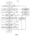
- a general method for determining when offline suggestions should be generated and when online suggestions should be merged with offline suggestions is discussed with reference to Fig. 3
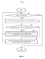
- a method for dynamically determining when offline suggestions should be generated in view of the length of the search prefix is discussed with reference to Fig. 4 .
- a method 200 can be implemented in the geographic application 110 as a set of software instructions executable on the processor(s) 102, for example.
- the blocks illustrated in Fig. 3 can be implemented in the offline suggestions module 130.
- the offline suggestions module 130 can execute the functionality of blocks 204, 206, 220, and 226, and the other blocks can be executed by other components of the geographic application 110.
- the offline suggestions module 130 can implement all of the blocks illustrated in Fig. 3 . More generally, however, the method 200 can be implemented in one or several software components in any suitable portable device.
- the method 200 begins at block 202 with a determination of whether a network connection is available. To this end, the method 200 can invoke an API exposed by the operating system of the portable device. It is noted that a portable device, such as the portable device 14 of Fig. 1 or the portable device 100 of Fig. 2 , in some cases can determine that no network connection is currently available with a high degree of accuracy. On the other hand, when the portable device determines that a network connection is available, it is difficult for the portable device to predict how quickly a certain message will reach a network node, and how quickly a response will arrive at the portable device.
- the flow proceeds to block 204, where offline suggestions are provided.
- offline suggestions As discussed in more detail below, whether offline suggestions are generated in some implementations further depends on the length of the search prefix.
- the method 200 can include providing an offline indicator to notify the user that the geospatial suggestions were not received from a network server (block 206).
- the offline indicator can be, for example, an icon or a text message.
- the method 200 can include providing an interactive control for requesting that the geographic application make another attempt to receive online geographic suggestions (block 206).
- the interactive control can be an interactive icon, a special-purpose key, or a key generally serving another purpose, such as the search key, activated in a particular manner (e.g., by a double tap).
- the method 200 completes. It is noted, however, that the method 200 can be invoked every time the user enters a new symbol.
- the request can be a message that includes the search prefix (e.g., "S" in the first instance of the message, "Sa” in the second instance of the message, "San” in the third instance, etc.), as well as an indication of the current context (e.g., navigation or search).
- the request includes only the last symbol the user added to the search prefix, so that in the first instance the message includes "S," in the second instance the message includes only "a” corresponding to the search prefix "Sa,” etc.
- the geographic application will fail to send the request due to lack of connectivity. In other cases, however, the geographic application initially may succeed at sending the message to a network server, but the message will not arrive at the network server in time or at all. Accordingly, timer T1 is activated at block 212.
- Timer T1 can correspond to a relatively short period of time, such as 100ms, for example. If online suggestions are received before timer T1 expires (block 214), the flow proceeds to block 216, where online suggestions are provided via a user interface.
- the network server can provide online suggestions in the form of an ordered list, for example, in which various search terms are listed in the order of probability. To continue with the example above, the suggestions for a certain user corresponding to search prefix "San" can include "San Francisco" with the probability 0.9, “San Jose” with the probability 0.8, etc.
- the network server can generate these suggestions using any suitable combination of signals, such as popularity of the suggested item, proximity of the suggested item to the user's current location, the user's previous searches and/or reviews, etc. In some of these implementations, the user operates certain controls and/or installs certain applications to allow the network server to utilize the user's data in this manner.
- the flow proceeds to block 220, where offline suggestions are provided via the user interface.
- offline suggestions are provided via the user interface.
- an offline indicator is activated as well. Similar to block 204 discussed above, the generation of offline suggestions may further depend on the current length of the search prefix.
- timer T2 can be activated to monitor arrival of "late" online suggestions.
- Timer T2 can be substantially longer than timer T1.
- timer T2 can be two or three seconds long.
- the method 200 determines whether online suggestions have been received (block 224). The method 200 completes if no late online suggestions arrived during the timer interval corresponding to timer T2. Otherwise, online suggestions are merged with offline suggestions (block 226). More particularly, offline suggestions can be compared with online suggestions to detect overlaps.
- online suggestion “Tokyo” for search prefix “Tok” can be expanded using the online suggestion for the same item to also include the Japanese characters for "Tokyo.”
- an online suggestion ranking between two offline suggestions matching online suggestions can be inserted into the list being displayed via the user interface.
- a list of offline suggestions can be augmented with one or more online suggestions not present in the offline suggestions.
- respective indications may be stored for some of the offline suggestions to indicate that these offline suggestions are considered sufficiently reliable, and do not require an update.
- timer T1 and/or timer T2 expires only if no acknowledgement to the request is received within a predetermined period of time. If an acknowledgement is received, the timer may be extended or another timer can be activated. In another implementation, however, timer T1 and/or timer T2 expires if no suggestions are received, regardless of whether the request is acknowledged.
- an example method 300 can be implemented along with the method 200 or separately from the method 200 in the geographic application 110. Similar to the method 200, the method 300 can be implemented as a set of software instructions executable on one or more processors.
- the method 300 begins at block 302, where it is determined whether user input has been completed. For example, it can be determined whether the user has actuated the "search" button yet.
- the input can be a part of a query that includes a geographic query. If input has not yet been completed, a new symbol is received at block 304 and added to the search prefix according to the current input language.
- a symbol can be a letter, a number, a syllable character, a space or another separator, a word character, a component of a word character, etc.
- the user can provide the symbol by typing the character, speaking or otherwise referencing the symbol via audio (e.g., voice) input, or in any other suitable fashion.
- the method 300 ends.
- a voice recognition system operating in the client device can generate a transliteration for words, symbols, individual letters, or other units of speech. These units can be send to a network server in a segmented fashion, such as letter-by-letter or word-by-word, or the audio data can be transmitted to the network server for processing, for example.
- Number n can be relatively small, such as 1, 2 or 3, for example, but in general the geographic application can be configured with any desired value of n. If it is determined that the search prefix contains fewer than n symbols, the flow proceeds to block 308. Otherwise, the flow proceeds to block 310.
- an attempt to provide online suggestions is made in a manner that is generally similar to the approach discussed above with reference to blocks 210 - 226. Offline suggestions may be more accurate as the prefix length increases, and thus no offline suggestions are provided at block 308 if the search prefix criteria of block 306 is not satisfied.
- a network server can utilize a robust set of signals, a large geospatial database, and execute a complex algorithm when necessary, a portable device has only limited access to resources in the offline mode and generally has lower computational ability as compared to a network server.
- offline suggestions are provided at block 310, where a longer search prefix can be more easily and accurately matched to geospatial terms.
- the user in an example scenario invokes the geographic application on a smartphone to search for nearby toy stores.
- the user activates the geographic search mode of the geographic application and begins to type in the search prefix.
- the geographic application checks availability of a network connection and, based on one or more signals from the operating system of the smartphone, determines that a network connection is available.
- the geographic application attempts to send a message to a network server via the communication stack of the smartphone.
- the message includes the current search prefix ⁇ t' and, in some implementations, other information such as the user's location, for example.
- the smartphone sends the message which does not reach the network server with the time period corresponding to the timer.
- the geographic application does not provide offline suggestions due to the short length of the prefix.
- the user continues to type in characters, 'o' to augment the search prefix to "to,” 'y' to augment the search prefix to "toy,” etc., and the geographic application can continue to attempt to obtain online geospatial suggestions, or at least query the operating system to check whether the network connection has become available.
- the geographic application When the search prefix has reached three characters, for example, the geographic application generates offline geospatial suggestions for the term "toy.”
- the geographic application also activates a longer timer to allow for the possibility that online geospatial suggestions will arrive at a later time. When several geospatial suggestions finally arrive, the geographic application merges the online and offline suggestions.
- the geographic application can be, for example, the geographic application 110 that implements one or both methods 200 and 300.
- the value of n is 3.
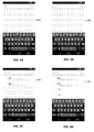
- a screenshot 402 in Fig. 5A illustrates the situation when the user begins to enter a search prefix and enters the letter "r."
- no online search suggestions can be retrieved sufficiently quickly (e.g., within the time interval corresponding to timer T1).
- Fig. 5B depicts a screenshot 404, where the user entered another letter to bring the search prefix to "re.” Because 2 ⁇ 3, and because no online suggestions can be retrieved in time in this scenario, no offline suggestions are generated.
- Screenshot 408 in Fig. 5D illustrates a merger of online suggestions with offline suggestions.
- online suggestions arrived after the shorter timeout expired but before a longer timeout expired (e.g., the timeout corresponding to timer T2 discussed above). Accordingly, while the search prefix remains the same (“res"), several online suggestions are added to the list of offline suggestions.
- Modules may constitute either software modules (e.g., code embodied on a machine-readable medium or in a transmission signal) or hardware modules.
- a hardware module is tangible unit capable of performing certain operations and may be configured or arranged in a certain manner.
- one or more computer systems e.g., a standalone, client or server computer system
- one or more hardware modules of a computer system e.g., a processor or a group of processors
- software e.g., an application or application portion
- any reference to "one implementation” or “an implementation” means that a particular element, feature, structure, or characteristic described in connection with the implementation is included in at least one implementation.
- the appearances of the phrase “in one implementation” in various places in the specification are not necessarily all referring to the same implementation.
- Coupled and “connected” along with their derivatives.
- some implementations may be described using the term “coupled” to indicate that two or more elements are in direct physical or electrical contact.
- the term “coupled,” however, may also mean that two or more elements are not in direct contact with each other, but yet still co-operate or interact with each other.
- the implementations are not limited in this context.
- the terms “comprises,” “comprising,” “includes,” “including,” “has,” “having” or any other variation thereof, are intended to cover a non-exclusive inclusion.
- a process, method, article, or apparatus that comprises a list of elements is not necessarily limited to only those elements but may include other elements not expressly listed or inherent to such process, method, article, or apparatus.
- “or” refers to an inclusive or and not to an exclusive or. For example, a condition A or B is satisfied by any one of the following: A is true (or present) and B is false (or not present), A is false (or not present) and B is true (or present), and both A and B are true (or present).
Landscapes
- Engineering & Computer Science (AREA)
- Theoretical Computer Science (AREA)
- Databases & Information Systems (AREA)
- Physics & Mathematics (AREA)
- General Physics & Mathematics (AREA)
- Data Mining & Analysis (AREA)
- General Engineering & Computer Science (AREA)
- Remote Sensing (AREA)
- Radar, Positioning & Navigation (AREA)
- Computational Linguistics (AREA)
- Automation & Control Theory (AREA)
- Telephonic Communication Services (AREA)
- Information Transfer Between Computers (AREA)
Applications Claiming Priority (1)
| Application Number | Priority Date | Filing Date | Title |
|---|---|---|---|
| US201462015427P | 2014-06-21 | 2014-06-21 |
Publications (1)
| Publication Number | Publication Date |
|---|---|
| EP2958032A1 true EP2958032A1 (fr) | 2015-12-23 |
Family
ID=53496431
Family Applications (1)
| Application Number | Title | Priority Date | Filing Date |
|---|---|---|---|
| EP15173013.2A Ceased EP2958032A1 (fr) | 2014-06-21 | 2015-06-19 | Intégration dynamique de suggestions hors ligne et en ligne dans une application géographique |
Country Status (5)
| Country | Link |
|---|---|
| US (1) | US10127324B2 (fr) |
| EP (1) | EP2958032A1 (fr) |
| CN (1) | CN105203121A (fr) |
| DE (1) | DE202015009118U1 (fr) |
| WO (1) | WO2015195926A1 (fr) |
Families Citing this family (8)
| Publication number | Priority date | Publication date | Assignee | Title |
|---|---|---|---|---|
| US12081594B2 (en) | 2015-10-28 | 2024-09-03 | Qomplx Llc | Highly scalable four-dimensional geospatial data system for simulated worlds |
| US20200389495A1 (en) * | 2015-10-28 | 2020-12-10 | Qomplx, Inc. | Secure policy-controlled processing and auditing on regulated data sets |
| US10963450B2 (en) * | 2017-01-25 | 2021-03-30 | Apple Inc. | Optimizing offline map data updates |
| US10713286B2 (en) * | 2017-06-27 | 2020-07-14 | Microsoft Technology Licensing, Llc | Storage of point of interest data on a user device for offline use |
| CN109672508A (zh) * | 2018-12-31 | 2019-04-23 | 叶春林 | 智能型防止车辆导航断网系统 |
| CN110567466B (zh) * | 2019-08-20 | 2022-11-25 | 广州力挚网络科技有限公司 | 一种地图生成方法、装置、电子设备以及可读存储介质 |
| CN110609843A (zh) * | 2019-09-24 | 2019-12-24 | 上海依图网络科技有限公司 | 一种通过合并不同数据来源提升检索召回率的方法及系统 |
| US12438916B2 (en) | 2020-05-13 | 2025-10-07 | Qomplx Llc | Intelligent automated planning system for large-scale operations |
Citations (4)
| Publication number | Priority date | Publication date | Assignee | Title |
|---|---|---|---|---|
| EP1320023A2 (fr) * | 2001-11-27 | 2003-06-18 | Nokia Corporation | Terminal de communication possédant une application d'éditeur de texte |
| EP2053526A1 (fr) * | 2007-07-25 | 2009-04-29 | MasterObjects Inc. | Système et procédé pour la récupération asynchrone d'informations basées sur une saisie incrémentale d'utilisateur |
| US20100325136A1 (en) * | 2009-06-23 | 2010-12-23 | Microsoft Corporation | Error tolerant autocompletion |
| US8645825B1 (en) * | 2011-08-31 | 2014-02-04 | Google Inc. | Providing autocomplete suggestions |
Family Cites Families (17)
| Publication number | Priority date | Publication date | Assignee | Title |
|---|---|---|---|---|
| US8037168B2 (en) * | 1999-07-15 | 2011-10-11 | Esdr Network Solutions Llc | Method, product, and apparatus for enhancing resolution services, registration services, and search services |
| JP4036012B2 (ja) * | 2001-04-26 | 2008-01-23 | トヨタ自動車株式会社 | 経路案内システム、経路案内を行うクライアント端末、同クライアント端末と通信を行うサーバ、経路案内方法及び経路一致判定方法 |
| DE10345051B4 (de) * | 2003-09-26 | 2009-04-09 | Siemens Ag | Verfahren zum Aufbau einer Kommunikationsverbindung in einem direkt kommunizierenden Kommunikationsnetzwerk |
| US7444278B2 (en) * | 2004-03-19 | 2008-10-28 | Microsoft Corporation | Method and system for synchronizing the user interface language between a software application and a web site |
| GB0418411D0 (en) * | 2004-08-18 | 2004-09-22 | King S College London | A method of discovering contact means for network access devices |
| US8126895B2 (en) | 2004-10-07 | 2012-02-28 | Computer Associates Think, Inc. | Method, apparatus, and computer program product for indexing, synchronizing and searching digital data |
| US20080242343A1 (en) * | 2007-03-26 | 2008-10-02 | Helio, Llc | Modeless electronic systems, methods, and devices |
| TW201118789A (en) * | 2009-09-09 | 2011-06-01 | Univ Trobe | Method and system for energy management |
| US20110071862A1 (en) * | 2009-09-24 | 2011-03-24 | GetThere, L.P. | Collaboration and travel ecosystem |
| US20120143900A1 (en) | 2010-12-06 | 2012-06-07 | Google Inc. | Instant Search For Settings |
| US9424357B1 (en) * | 2011-03-01 | 2016-08-23 | Amazon Technologies, Inc. | Predictive page loading based on text entry and search term suggestions |
| US9358460B2 (en) * | 2011-04-28 | 2016-06-07 | Numecent Holdings, Inc. | Adaptive cloud-based application streaming |
| US9378283B2 (en) | 2012-04-23 | 2016-06-28 | Excalibur Ip, Llc | Instant search results with page previews |
| US9275135B2 (en) * | 2012-05-29 | 2016-03-01 | International Business Machines Corporation | Annotating entities using cross-document signals |
| US9529924B2 (en) * | 2012-07-31 | 2016-12-27 | Apple Inc. | User interface providing localized search capabilities |
| US9116940B1 (en) * | 2013-04-15 | 2015-08-25 | Google Inc. | Searching for join candidates |
| US9626081B2 (en) * | 2014-05-19 | 2017-04-18 | The Travelers Indemnity Company | System for classification code selection |
-
2015
- 2015-06-18 WO PCT/US2015/036446 patent/WO2015195926A1/fr not_active Ceased
- 2015-06-18 US US14/743,477 patent/US10127324B2/en active Active
- 2015-06-19 EP EP15173013.2A patent/EP2958032A1/fr not_active Ceased
- 2015-06-19 DE DE202015009118.0U patent/DE202015009118U1/de not_active Expired - Lifetime
- 2015-06-23 CN CN201510350228.8A patent/CN105203121A/zh active Pending
Patent Citations (4)
| Publication number | Priority date | Publication date | Assignee | Title |
|---|---|---|---|---|
| EP1320023A2 (fr) * | 2001-11-27 | 2003-06-18 | Nokia Corporation | Terminal de communication possédant une application d'éditeur de texte |
| EP2053526A1 (fr) * | 2007-07-25 | 2009-04-29 | MasterObjects Inc. | Système et procédé pour la récupération asynchrone d'informations basées sur une saisie incrémentale d'utilisateur |
| US20100325136A1 (en) * | 2009-06-23 | 2010-12-23 | Microsoft Corporation | Error tolerant autocompletion |
| US8645825B1 (en) * | 2011-08-31 | 2014-02-04 | Google Inc. | Providing autocomplete suggestions |
Also Published As
| Publication number | Publication date |
|---|---|
| WO2015195926A1 (fr) | 2015-12-23 |
| DE202015009118U1 (de) | 2016-11-22 |
| US20150370811A1 (en) | 2015-12-24 |
| CN105203121A (zh) | 2015-12-30 |
| US10127324B2 (en) | 2018-11-13 |
Similar Documents
| Publication | Publication Date | Title |
|---|---|---|
| US10127324B2 (en) | Dynamically integrating offline and online suggestions in a geographic application | |
| JP6316980B2 (ja) | 自動的に決定された出発点と選択された目的地との間のナビゲーション案内 | |
| JP6343010B2 (ja) | ワイヤレスネットワークのアクセスポイントに関連したエンティティの識別 | |
| US10789078B2 (en) | Method and system for inputting information | |
| US9551586B2 (en) | System and method for providing contextual information for a location | |
| EP3896690B1 (fr) | Procédé et appareil d'interaction vocale, dispositif et support de stockage informatique | |
| RU2678077C2 (ru) | Способ отрисовки поисковых результатов на карте, отображаемой на электронном устройстве | |
| US20140310266A1 (en) | Systems and Methods for Suggesting Places for Persons to Meet | |
| US11301500B2 (en) | Clustering for geo-enriched data | |
| JP2020516980A (ja) | コンテキストディープブックマーキング | |
| US10984039B2 (en) | Hierarchical map visualizations of geo-enriched data | |
| US20160335290A1 (en) | Predictively presenting search capabilities | |
| CN106209940A (zh) | 信息推送方法及信息推送装置 | |
| WO2022089594A1 (fr) | Procédé et appareil d'affichage d'informations, et dispositif électronique | |
| US20170228105A1 (en) | Generation of Media Content for Transmission to a Device | |
| US10831791B1 (en) | Using location aliases | |
| EP3105691B1 (fr) | Incorporation automatique de cartes numériques dans des applications logicielles | |
| CN107247779A (zh) | 交互社区的搜索方法、装置及移动终端 | |
| CN113223522B (zh) | 语音识别方法、装置、设备和存储介质 | |
| CN105241460B (zh) | 一种路径生成方法及用户终端 | |
| CN114064953A (zh) | 图片搜索方法、装置、电子设备以及存储介质 | |
| JP5400813B2 (ja) | 住所検索装置及び住所検索方法 | |
| US20180113871A1 (en) | Map extent-based querying for geo-enriched data | |
| CN106774972B (zh) | 在文字输入中提供候选词的方法和装置 | |
| KR20190114634A (ko) | 광고 게시물을 전송하는 소셜 네트워크 서비스 제공 시스템 및 방법 |
Legal Events
| Date | Code | Title | Description |
|---|---|---|---|
| PUAI | Public reference made under article 153(3) epc to a published international application that has entered the european phase |
Free format text: ORIGINAL CODE: 0009012 |
|
| 17P | Request for examination filed |
Effective date: 20150619 |
|
| AK | Designated contracting states |
Kind code of ref document: A1 Designated state(s): AL AT BE BG CH CY CZ DE DK EE ES FI FR GB GR HR HU IE IS IT LI LT LU LV MC MK MT NL NO PL PT RO RS SE SI SK SM TR |
|
| AX | Request for extension of the european patent |
Extension state: BA ME |
|
| RAP1 | Party data changed (applicant data changed or rights of an application transferred) |
Owner name: GOOGLE LLC |
|
| 17Q | First examination report despatched |
Effective date: 20190221 |
|
| STAA | Information on the status of an ep patent application or granted ep patent |
Free format text: STATUS: THE APPLICATION HAS BEEN REFUSED |
|
| 18R | Application refused |
Effective date: 20191223 |
|
| P01 | Opt-out of the competence of the unified patent court (upc) registered |
Effective date: 20230519 |