EP3022528B1 - Procédé de fonctionnement d'un système de navigation, système de navigation et véhicule automobile - Google Patents
Procédé de fonctionnement d'un système de navigation, système de navigation et véhicule automobile Download PDFInfo
- Publication number
- EP3022528B1 EP3022528B1 EP14731913.1A EP14731913A EP3022528B1 EP 3022528 B1 EP3022528 B1 EP 3022528B1 EP 14731913 A EP14731913 A EP 14731913A EP 3022528 B1 EP3022528 B1 EP 3022528B1
- Authority
- EP
- European Patent Office
- Prior art keywords
- information
- navigation
- navigation device
- motor vehicle
- waypoint
- Prior art date
- Legal status (The legal status is an assumption and is not a legal conclusion. Google has not performed a legal analysis and makes no representation as to the accuracy of the status listed.)
- Not-in-force
Links
Images



Classifications
-
- G—PHYSICS
- G01—MEASURING; TESTING
- G01C—MEASURING DISTANCES, LEVELS OR BEARINGS; SURVEYING; NAVIGATION; GYROSCOPIC INSTRUMENTS; PHOTOGRAMMETRY OR VIDEOGRAMMETRY
- G01C21/00—Navigation; Navigational instruments not provided for in groups G01C1/00 - G01C19/00
- G01C21/26—Navigation; Navigational instruments not provided for in groups G01C1/00 - G01C19/00 specially adapted for navigation in a road network
- G01C21/34—Route searching; Route guidance
- G01C21/36—Input/output arrangements for on-board computers
- G01C21/3626—Details of the output of route guidance instructions
- G01C21/3644—Landmark guidance, e.g. using POIs or conspicuous other objects
-
- G—PHYSICS
- G01—MEASURING; TESTING
- G01C—MEASURING DISTANCES, LEVELS OR BEARINGS; SURVEYING; NAVIGATION; GYROSCOPIC INSTRUMENTS; PHOTOGRAMMETRY OR VIDEOGRAMMETRY
- G01C21/00—Navigation; Navigational instruments not provided for in groups G01C1/00 - G01C19/00
- G01C21/26—Navigation; Navigational instruments not provided for in groups G01C1/00 - G01C19/00 specially adapted for navigation in a road network
- G01C21/34—Route searching; Route guidance
- G01C21/36—Input/output arrangements for on-board computers
- G01C21/3602—Input other than that of destination using image analysis, e.g. detection of road signs, lanes, buildings, real preceding vehicles using a camera
Definitions
- the invention relates to a method for operating a navigation device, in particular in a motor vehicle.
- Navigation devices provide users with the ability to find a destination easily and easily. Therefore, navigation devices, in particular in motor vehicles and in particular of people who often drive unknown routes, like to use.
- the position of a user is usually determined, typically via the Global Positioning System GPS, and maps stored in the device and a route planning software installed on the device are used to guide a user to the destination.
- Such route guidance takes place in that the navigation device gives guidance to a user for navigation.
- this can be, for example, instructions for driving maneuvers to be carried out.
- the user In addition to the maneuver itself, so for example turn right, the user must be notified when this maneuver is to be performed. Especially in complex traffic situations this should be done early, so that the user can sufficiently prepare a driving maneuver to be performed.
- it is customary to provide a navigation instruction additionally with a distance indication or to use street names as orientation points. This allows navigation information such as "Turn left at 100 meters”, “Turn right at the next street", or "Drive onto Richard-Wagner-Strckee".
- the output of navigation hints is from the document EP1378724 A1 known.
- the invention is thus based on the object of specifying a method for operating a navigation device, which enables an improved output of navigation instructions on the other hand.
- the object is achieved by a method according to claim 1.
- the invention is based on the idea that it is far easier for a large number of users of navigation devices to adapt to everyday objects such as houses, parked vehicles, trees or something similar, than to street names. Thus, in daily life are often given directions, such as "turn right at the church" or the like.
- the object-based navigation has the advantage that markings for waypoints can be used, which immediately fall into the eye of the user of the navigation device. So it is far easier to recognize a particular building, a motor vehicle of a particular color or the like, as a street with a specific name, especially since street signs are often covered by other objects or at least are difficult to see from a distance.
- the steps of the method can all be performed by a navigation device.
- a navigation device can also be used by pedestrians, cyclists or the like.
- the method according to the invention for operating a navigation device can also be used on such devices.
- the use of the method according to the invention is particularly advantageous in motor vehicles, since these typically move at a higher speed than pedestrians, cyclists or the like.
- a navigation based on reference objects also offers significantly increased ride comfort.
- motor vehicles often have a plurality of additional sensors, in particular imaging sensors such as cameras or the like, with which a particularly good recognition of striking objects and thus a particularly good navigation with the method according to the invention is possible.
- the driver When carrying out the method according to the invention, the driver is to be provided with acoustic navigation information with which he is typically informed that a specific driving maneuver is to be carried out at a preceding waypoint of a planned route.
- a planned route typically includes a plurality of points at which certain driving maneuvers are to be performed by the driver, such as lane change, turning off roads, or the like.
- such information is typically emitted acoustically a certain amount of time before reaching the point at which the driving maneuver is to be carried out.
- a concrete object which marks the point at which the driving maneuver is to be carried out.
- a preceding waypoint is selected at which navigation information is to be output.
- this is the next waypoint where a driver's maneuver is necessary.
- environment data relating to the environment of the waypoint is collected.
- the motor vehicle it is possible for the motor vehicle to use a single data source, but it is also possible to use and in particular combine several data sources.
- Environmental data may be determined in particular by local databases, databases accessed via a wireless communication interface, or sensor data.
- a front camera of the motor vehicle can take a picture of the vehicle environment.
- image processing can be determined from a single camera image usually not only the solid angle in which an object is, but also the distance of the object. This makes it possible to identify objects that are near a waypoint ahead.
- databases with location-specific information such as lists of sights, address registers, aerial picture databases or the like.
- reference objects can be determined from the environment data.
- Such reference objects can be recognized for example by image recognition in images, but it is also possible that the object is described directly in the determined environment data.
- positions of buildings or the like can be recorded in databases.
- only the designation of a single reference object should be output. Therefore, for example, only one reference object can be determined.
- a reference object should fulfill several requirements. So a reference object should not change its position at least for the time it takes a user to reach the waypoint.
- a reference object should be easily recognizable. This makes it advantageous in this step to choose particularly large or particularly eye-catching objects.
- the reference object should also be clearly identifiable. For example, if many red parked cars are detected, a red parked car may be discarded as a reference object if other more suitable reference objects are detected.
- the reference object should serve in the method according to the invention for marking a waypoint. To achieve this purpose, however, the user must be told what this reference object is. The notification of the navigation information and thus of the reference object takes place acoustically in the method according to the invention. It is therefore necessary to acoustically reproduce the reference object, which is why a verbal designation is assigned to the reference object in the method according to the invention.
- Finding such a label can be particularly straightforward if the original environment data from which the item was found comes from a location-aware information database. Frequently, a designation for the reference object is already stored in this database and is therefore available in the method according to the invention. Even when detecting objects from sensor data, in particular from camera images, typically only certain objects are detected and identified. In this case, it is possible in particular for the navigation device to use a database which includes verbal designations for such known objects.
- the verbal designation for a reference object can first be determined in textual form and then prepared for example by a text-to-speech system or the like for an acoustic output, but it is also possible that databases are used, the directly spoken verbal designations for the Include reference objects.
- the verbal name may in particular be composed of at least one adjective and at least one noun.
- the adjective may be, for example, a color name or a size specification.
- Other adjectives, such as "parked” or the like may also be included, such that verbal designations such as For example, "parked red car", "big house” or the like can be formed.
- the name includes a company name, a business name, the type of the advertised object or the like. It is also possible to reproduce only parts of these names.
- navigation information typically also includes a navigation instruction, such as a driving instruction in motor vehicles, and possibly even relative information such as "before", “behind”, "at” or the like.
- a navigation instruction such as a driving instruction in motor vehicles
- relative information such as "before”, “behind”, "at” or the like.
- the navigation device can at least partially arrange the environmental data on the basis of sensor data from, in particular, the motor vehicle, Determine sensors.
- the sensor data can be evaluated by the navigation device itself, but it is also possible that the navigation device already uses preprocessed data.
- a driver assistance system of the motor vehicle may already include information about parked vehicles on the basis of sensor data. In this case, objects have already been identified and position information for these objects already exists. This information can then be supplemented, for example, by color information obtained from a camera image.
- sensor data may also be used to specify data originating, for example, from a database of location-specific information and / or to detect if a line-of-sight to particular reference objects is obstructed, thereby making it advantageous to assign other reference objects to form the navigation information use.
- the sensor data may be image data of an environment-sensing camera.
- a navigation device in the motor vehicle can be used in particular a front camera of the motor vehicle.
- Image data can be used in particular to determine a possible field of view of a user and thus to recognize which reference objects in the environment of the waypoint are particularly good or particularly bad to recognize.
- image information can easily provide additional information about objects that are detected by other methods, such as the color of an object or the like.
- image processing algorithms it is possible to already estimate a distance to an object from a two-dimensional image, whereby solely by image processing of the image data of a camera reference objects in the vicinity of the waypoint can be determined.
- certain advertising motifs or logos can also be recognized, and thus, for example, known product names can be used as part of a verbal designation for a reference object.
- the obtained image data can also be used with data from databases be combined and complemented by these or aligned with them.
- the navigation device determines the environment data at least partially by determining a position of the waypoint and evaluating at least one database with location-specific information.
- a database can be a digital map, as it already exists in most navigation devices.
- Such digital maps may include, for example, information about gas stations, restaurants, attractions or the like. Already with this information, a reference object can be determined in some traffic situations and thus an intuitively understandable navigation information can be output.
- navigation instructions such as "behind the gas station on the left" or the like are possible.
- digital maps with additional details In particular, databases with aerial photographs in which features can be detected or the like can be used. Also address directories, in particular industry books or the like can be used.
- the database it is possible for the database to be available locally, ie stored for example in a navigation device itself or in a memory device located outside the navigation device, for example in a motor vehicle.
- data storage such as drives for optical media or the like may additionally be provided.
- the database is external and access to the external database through wireless communication he follows.
- Such an external database may be a database providing navigation aids directly, but aerial photographs, address lists, maps, image services, and the like may also be used.
- the database is an Internet database.
- the wireless communication can be carried out in particular via a Car-2-X or a Car-2-Car Navigation.
- the reference object is a non-moving object for a minimum period.
- Reference objects should serve as fixed points in the method according to the invention, at which a user can orient themselves quickly and easily. If the reference object were to move between the time at which the navigation information is output and the time at which a user reaches the waypoint, this could lead to the user relating the navigation information to the wrong location and thus, for example, to one wrong road turns. It is often possible to detect reference objects in which it can be assumed with high certainty that no movement of the reference object takes place, at least for the period considered here. These can be, for example, houses, trees, billboards or similar fixed objects. According to the invention, however, it is also desirable to use parked vehicles as reference objects.
- various criteria can be used to predict with high probability whether or not a movement of such an object can be expected. For example, it can be determined by sensors whether the motor of a motor vehicle is running or not running, it can be recognized at the position of a motor vehicle whether this is located in a parking bay or on a road or the like.
- this also boundary conditions are taken into account, for example, whether a motor vehicle is at a traffic light or the like.
- a reference object may additionally also be a building or a plant or a stationary board.
- the panel may also be a signboard, in particular a traffic sign. Also advertising, so billboards, lift barrel columns or the like can be detected. Alternatively or additionally, a detection of signaling devices such as traffic lights, warning lights or the like is possible.
- a priority information is determined for the reference objects and, depending on the priority information, a reference object is selected whose designation is output.
- the priority information may, in particular, be a single numerical value that indicates how well a particular object is suitable as a reference object.
- a variety of criteria can be used. For example, based on camera data, it can be checked how well or how early before reaching the waypoint a reference object is visible to the driver. In addition, it can be checked how clearly a reference object can be identified. For example, on an avenue, a tree should not be used as a reference object, since in this case many similar reference objects are in the driver's field of vision and the navigation information thus becomes unclear.
- the priority information can continue to use the awareness of a reference point. Thus, it is typically assumed that a user knows well-known landmarks or well-known logos or the like and can thus easily orient themselves to them.
- the priority information can also take into account whether a reference object is completely immobile and, for example, has already been in one place for years. Such a reference object may be advantageous since a user of the navigation device is already familiar with the fact that this reference object is located at a specific location.
- the invention relates to a navigation device for guiding a user along a route determined by the navigation device, wherein the navigation device is designed to carry out one of the methods described above.
- the invention relates to a motor vehicle comprising the navigation device described above.
- Fig. 1 shows a flowchart of a method for operating a navigation device.
- the process starts in step S1.
- a plurality of preparatory steps are performed to determine a route.
- a route can be determined, for example, by a user inputting a destination via a user interface of the navigation device and the navigation device recognizing the EGO position of the user from location data of a location determination device, for example a GPS sensor.
- the navigation device can then calculate one or more routes from the user's EGO position to the destination.
- Such a route typically includes a plurality of waypoints, wherein at least to a subset of these waypoints, navigation information is to be output to a user.
- Such a waypoint may for example be an intersection or an intersection, at which a motor vehicle whose route is planned by the navigation device should turn.
- a navigation information for the temporally nearest waypoint is to be output.
- the explained method can be used exactly the same as for outputting a navigation information for a waypoint further away in time.
- step S2 the preceding waypoint to which navigation information is to be output to a user is determined. In the case under consideration, this is the closest waypoint in time.
- a navigation device continuously detects the ego position of a user, for example by evaluating GPS information.
- the waypoint is usually the absolute position of the waypoint, the street names in the area of the waypoint as well as the relative position of the waypoint to the user are known. This information could be used to directly generate navigation information with instructions such as "Turn right at 100 m" or "Turn into Richard-Wagner-Strckee".
- additional information is determined which makes it possible to acoustically output descriptions for reference objects additionally or alternatively, so that, for example, "can be output as the navigation information on the left at the billboard".
- first environmental data relating to the surroundings of the waypoint are determined in step S3.
- the determination of environmental data is possible in particular through the use of sensors and the use of databases.
- sensors sensors of the navigation device itself or sensors of a device comprising the navigation device, in particular of a motor vehicle, can be used to obtain environmental data.
- the environment of the waypoint can be detected optically and / or by additional sensors, and then pattern recognition, in particular image recognition, can be performed in order to detect reference objects in the sensor data.
- databases with location-specific information can also be used in step S3.
- navigation devices typically include digital maps that already include individual reference objects with associated locations such as gas stations, attractions, restaurants, and the like. This information can be used, for example, to generate navigation information such as "at the church right".
- the navigation device or other devices, which are in direct communication with the navigation device can comprise further databases.
- Internet databases can be used to gain further location-specific information.
- This information can be obtained in text form.
- address databases or the like can be used.
- the database used may provide information specifically for navigation purposes, but other databases may be used to advantage.
- step S4 at least one reference object, which is located in the vicinity of the waypoint, is determined from the environmental data obtained in step S3. It is possible that a large number of reference objects are detected in the vicinity of the waypoint. It is often advantageous to output only the designation of a single object when outputting the navigation information. Therefore, the reference objects can in particular also be given a priority which indicates how well the individual objects are suitable for navigation purposes.
- the priority may depend on whether an object is reliably unmoved, such as a house, or how well an object is recognizable by the user's ego position.
- an object is reliably unmoved, such as a house, or how well an object is recognizable by the user's ego position.
- Information about the reference object can already be available directly in a form that can be used in the method, for example as a result of a database query, but it is also possible that such information is only obtained by further image processing or the like.
- information from other motor vehicle systems can also be used.
- driver assistance systems can already provide information about other vehicles, in particular parked vehicles, or others solid boundary objects have been obtained, which can be used in the process as reference objects.
- step S4 is a single reference object or a list of reference objects that are located at the waypoint or in the vicinity of the waypoint, wherein advantageously further information about the reference object or objects has been determined.
- a verbal name is assigned to the reference object. It is possible, especially when using databases, that a verbal designation for the reference object already exists. When detecting objects in image data or other sensor data, typically also an object type is detected. This can be assigned to a verbal designation, for example via a dictionary given in the navigation device. Database queries can also be used in the step of assigning a verbal name. For example, logos or the like can be recognized, and a suitable name can be determined by means of a database query.
- a verbal name typically includes an object type.
- the object type may be relatively generic, i. H. So for example, motor vehicles only generally as a car, truck or motorcycle to designate and no more precise type specifications, as a variety of users can not easily distinguish motor vehicle types. The same applies to plants or buildings.
- other information that is very easily recognizable to a typical user such as the color of an object or the like, can be used as part of the verbal label.
- Other adjectives that refer to properties of reference objects can also be used.
- the verbal label may include size information, color information, or the like.
- the verbal designation determined in step S5 is first determined in text form. In this case, subsequently, for example, an output via a text-to-speech system take place. But it is also possible to determine the verbal name directly in a form that allows a direct acoustic reproduction. For example, can directly generate a PCM encoded waveform, or playlists for multiple audio objects can be created.
- navigation information is created that includes the previously generated verbal label.
- the creation of the navigation information may be similar, as in known methods that use street names to mark waypoints.
- the navigation information thus typically includes, in addition to the verbal designation, an instruction to the user, for example a driving instruction such as "turn right" and possibly information indicating in which position the reference object is located with respect to the waypoint.
- the navigation information can be formed in many ways. Thus, the navigation information can be directly calculated as audio information to allow easy acoustic output, but it is also possible to create the navigation information in text form, which is then converted via a text-to-speech system or the like.
- step S7 the acoustic output of the navigation information takes place. This can be done via a speaker of the navigation device itself, but it is also possible that the navigation device uses other speakers. In particular, a loudspeaker of a motor vehicle can be used.
- step S8 The procedure can be repeated for any number of waypoints.
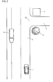
- Fig. 2 and Fig. 3 show typical traffic situations in which the method for operating the navigation device can be used.
- the traffic situations shown are identical except for the presence or absence of the truck 7.
- a motor vehicle 1 moves on a road 2.
- a navigation device is present, which has previously calculated a route that predetermines a turning of the motor vehicle 1 from the road 2 into a road 3.
- the junction 25 forms a waypoint of the route and with respect to the junction 25 should the navigation information is output that the motor vehicle should turn right at the junction 25.
- the navigation device therefore attempts to determine reference objects in the vicinity of the waypoint, ie the junction 25, in order to enable an output of the navigation information which comprises a verbal designation of the reference object.
- the motor vehicle 1 in the in Fig. 2 shown traffic situation that at the junction 25 is a restaurant 5.
- a vehicle camera of the motor vehicle 1 also a tree 4 and a parking truck 6 are detected. Three reference objects are thus determined.
- the navigation device can ascertain that the restaurant 5, viewed from the ego position of the motor vehicle, is almost completely covered by the tree 4 and also remains hidden from the junction 25 on further movement of the motor vehicle 1. Therefore, the restaurant 5 is assigned a low priority.
- the tree 4 and the truck 6 are almost equally visible. However, since a movement of the tree 4 is far less likely than a movement of the parked truck 6, is for tree 4 in the in Fig. 2 shown traffic situation a higher priority. Thus, tree 4 is determined to reference object and as navigation information, for example, "turn right behind the tree" are output.
- Fig. 3 shown traffic situation corresponds to the in Fig. 2 However, in front of motor vehicle 1 is another truck 7. In determining the priority information is further found that the restaurant 5 from the Ego position of the motor vehicle 1 is difficult to see. Thus, the restaurant 5 is still assigned a low priority. In contrast to the traffic situation in Fig. 2 can the navigation device of the motor vehicle 1 in the traffic situation in Fig. 3 however, notice that tree 4 is partially covered by the Truck 7 is hidden and thus far less recognizable to the user of the navigation device than the truck 6. Thus, the truck 6 is assigned the highest priority and it can be a navigation information such as "behind the truck 6 turn right" output.
- truck 7 In order to make it possible to distinguish clearly from truck 7, it is also possible, for example, to output the navigation information "turn right behind the parked truck" or, if, for example, it has been determined within the scope of image recognition that truck 6 is green, "turn right behind the green truck turn".
- Fig. 4 shows a flow chart for the detection and selection of reference objects.
- step S11 first sensor information, here an image of a camera, is detected.
- the image data acquired in step S11 are evaluated in step S12, and one or more objects are recognized in the image data.
- step S13 from among the objects recognized in step S12, a plurality of objects located in the vicinity of the waypoint and presumed to be unmoved are selected.
- Being immobile of an object can be assumed, for example, when a fixed object, such as a house or the like, is recognized. However, it can also be determined by the evaluation of further sensor information that the engine of a detected motor vehicle is not running and thus it can be assumed that the motor vehicle is not moving or the like. Also, a detection of a stationary object for a long time, without a recognizable cause, such as a traffic light circuit or the like, given for the standing of the object can be interpreted as an indication that the object is a still object.
- step S14 the coordinate of the waypoint is first determined for this purpose. Often, such a coordinate has already been determined during the route planning and lies with it before.
- step S15 a database of location-specific information is read out. This may be, for example, an Internet database in which position information is available for a plurality of buildings or the like. From this database, objects in the vicinity of the waypoint are read out and determined as reference objects.
- step S16 a priority is respectively determined for the objects determined in step S13 and S15 for reference objects, with which it is determined which of these reference objects is to be used to generate the navigation information.
- priority information may be determined from an actual or anticipated visibility of the object, the uniqueness of the object, the likelihood that the object will be stationary, or the like.
- Step S17 the reference object with the highest priority information is selected.
- step S18 the reference object is thus selected and the method can be continued with the assignment of a verbal designation to the reference object, that is, for example, with step S5 Fig. 1 ,
- Fig. 5 schematically shows an embodiment of a navigation device, which is designed for carrying out some of the described methods.
- the navigation device 8 includes a computing device 9 with an associated memory 10.
- the computing device 9 also reads the information of a position sensor 11, which is designed as a GPS sensor, can drive a communication device 12, which here establishes a wireless connection to the Internet, and audio information about output the speaker 13.
- an operating device 14 is actuated and read via the computing device 9, which allows both an image display and therefore also user inputs.
- a route can be planned in the computer 9 by using a digital map stored in the associated memory 10. For a leading waypoint of this route can be determined using the digital map and additional database queries via the communication device 12, a reference object.
- this waveform can then be output to the speaker 13.
- Fig. 6 shows an embodiment of a motor vehicle, which includes a navigation device 16, which can perform the described method.
- the navigation device 16 comprises a computing device 17, as well as an associated memory 18, which comprises a digital map.
- a communication via a communication device of the motor vehicle 20 the position is determined by a position determining device 19 of the motor vehicle and a user interface via a user interface 22, which includes both a graphical display option and input means.
- a control element 22 is a combination of a display and a rotary control.
- Navigation information may be output via the speaker 21, which is part of the audio system of the motor vehicle.
- the individual components of the motor vehicle 15 communicate via a CAN bus.
- the navigation device 16 can still resort to image information of a camera 24 on the front of the motor vehicle, an additional data memory 23, as well as object information from a driver assistance system 26. Opposite the in Fig. 5 navigation system shown it is thus the navigation system 16 in the motor vehicle 15 additionally possible to determine reference objects by images of the camera 24 are evaluated.
- existing databases can additionally be used in the data memory 23.
- the driver assistance system 26 can also provide additional information, for example, via further motor vehicles. In particular, it is known that driver assistance systems also detect and identify parking motor vehicles.
Landscapes
- Engineering & Computer Science (AREA)
- Radar, Positioning & Navigation (AREA)
- Remote Sensing (AREA)
- Automation & Control Theory (AREA)
- Physics & Mathematics (AREA)
- General Physics & Mathematics (AREA)
- Computer Vision & Pattern Recognition (AREA)
- Navigation (AREA)
- Traffic Control Systems (AREA)
Claims (6)
- Procédé de fonctionnement d'un système de navigation, en particulier dans un véhicule automobile,
comprenant les étapes de :- détermination d'un point de cheminement à venir d'un itinéraire planifié par le système de navigation, par rapport auquel une information de navigation doit être émise à un utilisateur- détermination de données environnementales concernant l'environnement du point de cheminement au moins en partie à l'aide de données d'image d'une caméra détectant l'environnement, agencée au niveau du véhicule automobile par le système de navigation,- détermination d'au moins un objet de référence se trouvant dans l'environnement du point de cheminement par reconnaissance d'image dans les données d'image à partir des données environnementales,- affectation d'une désignation verbale à l'objet de référence,- création de l'information de navigation comprenant la désignation, et- émission acoustique de l'information de navigation ;caractérisé en ce qu'un véhicule garé, qui ne se déplace pas, est déterminé en tant qu'objet de référence, dans lequel il est déterminé si un mouvement du véhicule garé peut être attendu, en déterminant par le biais de capteurs si le moteur du véhicule garé tourne et/ou si le véhicule garé se trouve dans une aire de stationnement ou sur une route et/ou si un non-mouvement du véhicule garé est observé pour un temps minimum prévu. - Procédé selon la revendication 1,
caractérisé en ce
que le système de navigation détermine les données environnementales au moins en partie par détermination d'une position du point de cheminement et évaluation d'au moins une base de données avec des informations locales. - Procédé selon la revendication 2,
caractérisé en ce
que la base de données est externe et l'accès à la base de données externe se fait par communication sans fil. - Procédé selon l'une quelconque des revendications précédentes,
caractérisé en ce
que lors de la détermination de plusieurs objets de référence, une information de priorité est déterminée pour les objets de référence et en fonction de l'information de priorité, un objet de référence est sélectionné dont la désignation est émise. - Système de navigation pour le guidage d'un utilisateur le long d'un itinéraire déterminé par le système de navigation,
caractérisé en ce
qu'il est réalisé pour la réalisation d'un procédé selon l'une quelconque des revendications précédentes. - Véhicule,
caractérisé en ce
qu'il comprend un système de navigation selon la revendication 5.
Applications Claiming Priority (2)
| Application Number | Priority Date | Filing Date | Title |
|---|---|---|---|
| DE102013011827.1A DE102013011827A1 (de) | 2013-07-15 | 2013-07-15 | Verfahren zum Betrieb einer Navigationseinrichtung, Navigationseinrichtung und Kraftfahrzeug |
| PCT/EP2014/001691 WO2015007362A1 (fr) | 2013-07-15 | 2014-06-21 | Procédé de fonctionnement d'un système de navigation, système de navigation et véhicule automobile |
Publications (2)
| Publication Number | Publication Date |
|---|---|
| EP3022528A1 EP3022528A1 (fr) | 2016-05-25 |
| EP3022528B1 true EP3022528B1 (fr) | 2018-11-21 |
Family
ID=50980265
Family Applications (1)
| Application Number | Title | Priority Date | Filing Date |
|---|---|---|---|
| EP14731913.1A Not-in-force EP3022528B1 (fr) | 2013-07-15 | 2014-06-21 | Procédé de fonctionnement d'un système de navigation, système de navigation et véhicule automobile |
Country Status (5)
| Country | Link |
|---|---|
| US (1) | US9726512B2 (fr) |
| EP (1) | EP3022528B1 (fr) |
| CN (1) | CN105393087B (fr) |
| DE (1) | DE102013011827A1 (fr) |
| WO (1) | WO2015007362A1 (fr) |
Families Citing this family (14)
| Publication number | Priority date | Publication date | Assignee | Title |
|---|---|---|---|---|
| DE102015007795A1 (de) | 2015-06-19 | 2015-12-17 | Daimler Ag | Verfahren zum Betrieb einer Navigationseinrichtung und Navigationsvorrichtung |
| US10126141B2 (en) * | 2016-05-02 | 2018-11-13 | Google Llc | Systems and methods for using real-time imagery in navigation |
| KR102353486B1 (ko) * | 2017-07-18 | 2022-01-20 | 엘지전자 주식회사 | 이동 단말기 및 그 제어 방법 |
| DE102017007705A1 (de) * | 2017-08-14 | 2019-02-14 | Preh Car Connect Gmbh | Ausgeben einer Manöveranweisung mittels einer Navigationseinrichtung |
| DE102018005869A1 (de) * | 2018-07-25 | 2020-01-30 | Zf Active Safety Gmbh | System zur Erstellung eines Umgebungsmodells eines Fahrzeugs |
| CN111213031A (zh) * | 2018-12-06 | 2020-05-29 | 深圳市大疆创新科技有限公司 | 一种导航处理方法、装置及导航处理设备 |
| DE102018133669A1 (de) | 2018-12-28 | 2020-07-02 | Volkswagen Aktiengesellschaft | Verfahren und Vorrichtung zur Wiedergabe von Navigationshinweisen |
| CN109672508A (zh) * | 2018-12-31 | 2019-04-23 | 叶春林 | 智能型防止车辆导航断网系统 |
| CN110501007B (zh) * | 2019-09-06 | 2021-07-16 | 腾讯科技(深圳)有限公司 | 一种路径规划方法、装置及终端 |
| DE102019128253B4 (de) * | 2019-10-18 | 2024-06-06 | StreetScooter GmbH | Verfahren zum Navigieren eines Flurförderzeugs |
| JP2022059958A (ja) * | 2020-10-02 | 2022-04-14 | フォルシアクラリオン・エレクトロニクス株式会社 | ナビゲーション装置 |
| CN115077536A (zh) * | 2021-03-05 | 2022-09-20 | 博泰车联网科技(上海)股份有限公司 | 导航提示方法和导航提示装置、存储介质以及电子设备 |
| CN113514863A (zh) * | 2021-03-23 | 2021-10-19 | 重庆兰德适普信息科技有限公司 | 一种多传感器融合定位方法 |
| US20250044113A1 (en) * | 2023-07-31 | 2025-02-06 | Ford Global Technologies, Llc | Enhanced navigation prompt systems and methods |
Family Cites Families (20)
| Publication number | Priority date | Publication date | Assignee | Title |
|---|---|---|---|---|
| JP2001324345A (ja) * | 2000-05-15 | 2001-11-22 | Alpine Electronics Inc | ナビゲーション装置及びナビゲーション装置の経路案内方法 |
| DE10041714A1 (de) | 2000-08-25 | 2002-05-16 | Volkswagen Ag | Vorrichtung zur Objektmarkierung und/oder Detektion und Identifikation von Objekten |
| US6477460B2 (en) * | 2001-02-27 | 2002-11-05 | Metro One Telecommunications, Inc. | Process and system for the annotation of machine-generated directions with easily recognized landmarks and other relevant information |
| DE60304254T2 (de) * | 2002-07-01 | 2006-12-14 | Mazda Motor Corp., Shinchi | Zielführungssystem basiert auf visueller Tätigkeit des Fahrers |
| US8836580B2 (en) * | 2005-05-09 | 2014-09-16 | Ehud Mendelson | RF proximity tags providing indoor and outdoor navigation and method of use |
| DE102006010481A1 (de) | 2006-03-07 | 2007-09-13 | Robert Bosch Gmbh | Verfahren und Anordnung zur Anzeige von Navigationshinweisen |
| DE102006010478A1 (de) | 2006-03-07 | 2007-09-13 | Robert Bosch Gmbh | Verfahren und Anordnung zur Anzeige von Navigationshinweisen |
| JP4935145B2 (ja) * | 2006-03-29 | 2012-05-23 | 株式会社デンソー | カーナビゲーション装置 |
| FR2904910B1 (fr) * | 2006-08-14 | 2009-02-06 | Ulis Soc Par Actions Simplifie | Detecteur de rayonnement infrarouge et dispositif d'aide a la conduite ou au pilotage comprenant un tel dispositif |
| EP1906339B1 (fr) | 2006-09-01 | 2016-01-13 | Harman Becker Automotive Systems GmbH | Procédé pour reconnaître un objet dans une image et dispositif de reconnaissance d'image |
| DE112008003341T5 (de) * | 2007-12-28 | 2011-02-03 | Mitsubishi Electric Corp. | Navigationsvorrichtung |
| JP4775391B2 (ja) | 2008-03-18 | 2011-09-21 | 株式会社デンソー | 障害物検出装置 |
| DE102008041295A1 (de) | 2008-08-18 | 2010-02-25 | Robert Bosch Gmbh | Mobiles Navigationsgerät und diesbezügliches Verfahren |
| JP5517029B2 (ja) * | 2009-03-25 | 2014-06-11 | ニプロ株式会社 | 薬液自己注入装置 |
| US8060302B2 (en) * | 2009-03-31 | 2011-11-15 | Microsoft Corporation | Visual assessment of landmarks |
| US8364398B2 (en) | 2009-08-28 | 2013-01-29 | Navteq B.V. | Method of operating a navigation system to provide route guidance |
| AU2010202508A1 (en) * | 2010-04-28 | 2011-11-17 | Here Global B.V. | Method of operating a navigation system to provide route guidance |
| JP5569365B2 (ja) * | 2010-11-30 | 2014-08-13 | アイシン・エィ・ダブリュ株式会社 | 案内装置、案内方法、及び案内プログラム |
| JP5625987B2 (ja) * | 2011-02-16 | 2014-11-19 | アイシン・エィ・ダブリュ株式会社 | 案内装置、案内方法、および、案内プログラム |
| DE102011084993A1 (de) | 2011-10-21 | 2013-04-25 | Robert Bosch Gmbh | Übernahme von Daten aus bilddatenbasierenden Kartendiensten in ein Assistenzsystem |
-
2013
- 2013-07-15 DE DE102013011827.1A patent/DE102013011827A1/de not_active Withdrawn
-
2014
- 2014-06-21 WO PCT/EP2014/001691 patent/WO2015007362A1/fr not_active Ceased
- 2014-06-21 CN CN201480040149.0A patent/CN105393087B/zh not_active Expired - Fee Related
- 2014-06-21 EP EP14731913.1A patent/EP3022528B1/fr not_active Not-in-force
- 2014-06-21 US US14/905,186 patent/US9726512B2/en not_active Expired - Fee Related
Non-Patent Citations (1)
| Title |
|---|
| None * |
Also Published As
| Publication number | Publication date |
|---|---|
| CN105393087A (zh) | 2016-03-09 |
| US20160178389A1 (en) | 2016-06-23 |
| US9726512B2 (en) | 2017-08-08 |
| EP3022528A1 (fr) | 2016-05-25 |
| CN105393087B (zh) | 2018-10-19 |
| WO2015007362A1 (fr) | 2015-01-22 |
| DE102013011827A1 (de) | 2015-01-15 |
Similar Documents
| Publication | Publication Date | Title |
|---|---|---|
| EP3022528B1 (fr) | Procédé de fonctionnement d'un système de navigation, système de navigation et véhicule automobile | |
| DE102021100584A1 (de) | Erfassung und klassifizierung von sirenensignalen und lokalisierung von sirenensignalquellen | |
| EP2289058B1 (fr) | Procédé de sortie combinée d'une image et d'une information locale, et véhicule à moteur associé | |
| DE112020000110T5 (de) | Nutzung von in fahrzeugen erfassten fahrgastaufmerksamkeitsdaten fürlokalisierungs- und standortbezogene dienste | |
| EP3649519B1 (fr) | Procédé pour faire vérifier la carte numérique d'un véhicule très automatisé, dispositif correspondant et programme d'ordinateur | |
| DE102017211821A1 (de) | Systeme und Verfahren zur Minimierung einer Fahrerablenkung von einem Head-Up Display (HUD) in einem Fahrzeug | |
| DE112013007522T5 (de) | Fahrassistenzgerät und Fahrassistenzverfahren | |
| DE102011084993A1 (de) | Übernahme von Daten aus bilddatenbasierenden Kartendiensten in ein Assistenzsystem | |
| EP2583263A1 (fr) | Procédé pour fusionner un système de reconnaissance d'un panneau de signalisation et un système de reconnaissance de voie d'un véhicule automobile | |
| DE112012007236T5 (de) | Sichtbarkeitsschätzungsgerät, Sichtbarkeitsschätzungsverfahren und Fahrsicherheitsunterstützungssystem | |
| DE102018119882A1 (de) | Übertragen von Bilddaten, die von einer Fahrzeugkamera aufgenommen werden | |
| DE102019122266A1 (de) | Systeme und Verfahren zur Parkverwaltung | |
| DE102012213344A1 (de) | Verkehrszeichenerkennung | |
| DE102011082398A1 (de) | Verfahren zur Nutzung eines Fahrerassistenzsystems | |
| DE10241975A1 (de) | System und Verfahren zum Aufnehmen nicht-hörbarer Informationen zum Verarbeiten | |
| DE102014208310A1 (de) | Fahrerassistenzsystem zur Darstellung einer erweiterten Realität | |
| DE102018132487A1 (de) | Fahrzeugüberwachung von infrastrukturbeleuchtung | |
| DE102017209240B4 (de) | Verfahren zur Ansteuerung wenigstens einer Vorrichtung von einem Kraftfahrzeug | |
| DE102017208854A1 (de) | Verfahren, Vorrichtungen und computerlesbares Speichermedium mit Instruktionen zum Ermitteln von geltenden Verkehrsregeln für ein Kraftfahrzeug | |
| DE112020003033T5 (de) | Verfahren und Vorrichtung zum Verbessern einer Geolokalisierungsdatenbank | |
| DE102013206208B4 (de) | Fahrzeug mit automatischem Parklicht | |
| DE102010027768A1 (de) | Verfahren und Fahrerinformationssystem zur Darstellung eines Kurvenverlaufs auf einer Anzeigeeinrichtung | |
| EP2800671A1 (fr) | Procédé et dispositif d'information du conducteur | |
| DE102008043756A1 (de) | Verfahren und Steuergerät zum Bereitstellen einer Verkehrszeicheninformation | |
| DE102012208733A1 (de) | Verfahren und Vorrichtung zum Ermitteln zumindest eines Objekts |
Legal Events
| Date | Code | Title | Description |
|---|---|---|---|
| PUAI | Public reference made under article 153(3) epc to a published international application that has entered the european phase |
Free format text: ORIGINAL CODE: 0009012 |
|
| 17P | Request for examination filed |
Effective date: 20160215 |
|
| AK | Designated contracting states |
Kind code of ref document: A1 Designated state(s): AL AT BE BG CH CY CZ DE DK EE ES FI FR GB GR HR HU IE IS IT LI LT LU LV MC MK MT NL NO PL PT RO RS SE SI SK SM TR |
|
| AX | Request for extension of the european patent |
Extension state: BA ME |
|
| RIN1 | Information on inventor provided before grant (corrected) |
Inventor name: HAINZLMAIER, ANDRE Inventor name: PROFENDINER, DANIEL Inventor name: ENNING, MARTIN Inventor name: PHAM, VIET HOANG Inventor name: HEINEMANN, PATRICK |
|
| DAX | Request for extension of the european patent (deleted) | ||
| GRAP | Despatch of communication of intention to grant a patent |
Free format text: ORIGINAL CODE: EPIDOSNIGR1 |
|
| STAA | Information on the status of an ep patent application or granted ep patent |
Free format text: STATUS: GRANT OF PATENT IS INTENDED |
|
| INTG | Intention to grant announced |
Effective date: 20180731 |
|
| GRAS | Grant fee paid |
Free format text: ORIGINAL CODE: EPIDOSNIGR3 |
|
| GRAA | (expected) grant |
Free format text: ORIGINAL CODE: 0009210 |
|
| STAA | Information on the status of an ep patent application or granted ep patent |
Free format text: STATUS: THE PATENT HAS BEEN GRANTED |
|
| AK | Designated contracting states |
Kind code of ref document: B1 Designated state(s): AL AT BE BG CH CY CZ DE DK EE ES FI FR GB GR HR HU IE IS IT LI LT LU LV MC MK MT NL NO PL PT RO RS SE SI SK SM TR |
|
| REG | Reference to a national code |
Ref country code: CH Ref legal event code: EP |
|
| REG | Reference to a national code |
Ref country code: IE Ref legal event code: FG4D Free format text: LANGUAGE OF EP DOCUMENT: GERMAN |
|
| REG | Reference to a national code |
Ref country code: DE Ref legal event code: R096 Ref document number: 502014010153 Country of ref document: DE |
|
| REG | Reference to a national code |
Ref country code: AT Ref legal event code: REF Ref document number: 1068065 Country of ref document: AT Kind code of ref document: T Effective date: 20181215 |
|
| REG | Reference to a national code |
Ref country code: NL Ref legal event code: MP Effective date: 20181121 |
|
| PG25 | Lapsed in a contracting state [announced via postgrant information from national office to epo] |
Ref country code: FI Free format text: LAPSE BECAUSE OF FAILURE TO SUBMIT A TRANSLATION OF THE DESCRIPTION OR TO PAY THE FEE WITHIN THE PRESCRIBED TIME-LIMIT Effective date: 20181121 Ref country code: IS Free format text: LAPSE BECAUSE OF FAILURE TO SUBMIT A TRANSLATION OF THE DESCRIPTION OR TO PAY THE FEE WITHIN THE PRESCRIBED TIME-LIMIT Effective date: 20190321 Ref country code: HR Free format text: LAPSE BECAUSE OF FAILURE TO SUBMIT A TRANSLATION OF THE DESCRIPTION OR TO PAY THE FEE WITHIN THE PRESCRIBED TIME-LIMIT Effective date: 20181121 Ref country code: LT Free format text: LAPSE BECAUSE OF FAILURE TO SUBMIT A TRANSLATION OF THE DESCRIPTION OR TO PAY THE FEE WITHIN THE PRESCRIBED TIME-LIMIT Effective date: 20181121 Ref country code: BG Free format text: LAPSE BECAUSE OF FAILURE TO SUBMIT A TRANSLATION OF THE DESCRIPTION OR TO PAY THE FEE WITHIN THE PRESCRIBED TIME-LIMIT Effective date: 20190221 Ref country code: LV Free format text: LAPSE BECAUSE OF FAILURE TO SUBMIT A TRANSLATION OF THE DESCRIPTION OR TO PAY THE FEE WITHIN THE PRESCRIBED TIME-LIMIT Effective date: 20181121 Ref country code: ES Free format text: LAPSE BECAUSE OF FAILURE TO SUBMIT A TRANSLATION OF THE DESCRIPTION OR TO PAY THE FEE WITHIN THE PRESCRIBED TIME-LIMIT Effective date: 20181121 Ref country code: NO Free format text: LAPSE BECAUSE OF FAILURE TO SUBMIT A TRANSLATION OF THE DESCRIPTION OR TO PAY THE FEE WITHIN THE PRESCRIBED TIME-LIMIT Effective date: 20190221 |
|
| PG25 | Lapsed in a contracting state [announced via postgrant information from national office to epo] |
Ref country code: PT Free format text: LAPSE BECAUSE OF FAILURE TO SUBMIT A TRANSLATION OF THE DESCRIPTION OR TO PAY THE FEE WITHIN THE PRESCRIBED TIME-LIMIT Effective date: 20190321 Ref country code: AL Free format text: LAPSE BECAUSE OF FAILURE TO SUBMIT A TRANSLATION OF THE DESCRIPTION OR TO PAY THE FEE WITHIN THE PRESCRIBED TIME-LIMIT Effective date: 20181121 Ref country code: RS Free format text: LAPSE BECAUSE OF FAILURE TO SUBMIT A TRANSLATION OF THE DESCRIPTION OR TO PAY THE FEE WITHIN THE PRESCRIBED TIME-LIMIT Effective date: 20181121 Ref country code: GR Free format text: LAPSE BECAUSE OF FAILURE TO SUBMIT A TRANSLATION OF THE DESCRIPTION OR TO PAY THE FEE WITHIN THE PRESCRIBED TIME-LIMIT Effective date: 20190222 Ref country code: NL Free format text: LAPSE BECAUSE OF FAILURE TO SUBMIT A TRANSLATION OF THE DESCRIPTION OR TO PAY THE FEE WITHIN THE PRESCRIBED TIME-LIMIT Effective date: 20181121 Ref country code: SE Free format text: LAPSE BECAUSE OF FAILURE TO SUBMIT A TRANSLATION OF THE DESCRIPTION OR TO PAY THE FEE WITHIN THE PRESCRIBED TIME-LIMIT Effective date: 20181121 |
|
| PG25 | Lapsed in a contracting state [announced via postgrant information from national office to epo] |
Ref country code: IT Free format text: LAPSE BECAUSE OF FAILURE TO SUBMIT A TRANSLATION OF THE DESCRIPTION OR TO PAY THE FEE WITHIN THE PRESCRIBED TIME-LIMIT Effective date: 20181121 Ref country code: CZ Free format text: LAPSE BECAUSE OF FAILURE TO SUBMIT A TRANSLATION OF THE DESCRIPTION OR TO PAY THE FEE WITHIN THE PRESCRIBED TIME-LIMIT Effective date: 20181121 Ref country code: DK Free format text: LAPSE BECAUSE OF FAILURE TO SUBMIT A TRANSLATION OF THE DESCRIPTION OR TO PAY THE FEE WITHIN THE PRESCRIBED TIME-LIMIT Effective date: 20181121 Ref country code: PL Free format text: LAPSE BECAUSE OF FAILURE TO SUBMIT A TRANSLATION OF THE DESCRIPTION OR TO PAY THE FEE WITHIN THE PRESCRIBED TIME-LIMIT Effective date: 20181121 |
|
| REG | Reference to a national code |
Ref country code: DE Ref legal event code: R097 Ref document number: 502014010153 Country of ref document: DE |
|
| PG25 | Lapsed in a contracting state [announced via postgrant information from national office to epo] |
Ref country code: SK Free format text: LAPSE BECAUSE OF FAILURE TO SUBMIT A TRANSLATION OF THE DESCRIPTION OR TO PAY THE FEE WITHIN THE PRESCRIBED TIME-LIMIT Effective date: 20181121 Ref country code: RO Free format text: LAPSE BECAUSE OF FAILURE TO SUBMIT A TRANSLATION OF THE DESCRIPTION OR TO PAY THE FEE WITHIN THE PRESCRIBED TIME-LIMIT Effective date: 20181121 Ref country code: EE Free format text: LAPSE BECAUSE OF FAILURE TO SUBMIT A TRANSLATION OF THE DESCRIPTION OR TO PAY THE FEE WITHIN THE PRESCRIBED TIME-LIMIT Effective date: 20181121 Ref country code: SM Free format text: LAPSE BECAUSE OF FAILURE TO SUBMIT A TRANSLATION OF THE DESCRIPTION OR TO PAY THE FEE WITHIN THE PRESCRIBED TIME-LIMIT Effective date: 20181121 |
|
| PLBE | No opposition filed within time limit |
Free format text: ORIGINAL CODE: 0009261 |
|
| STAA | Information on the status of an ep patent application or granted ep patent |
Free format text: STATUS: NO OPPOSITION FILED WITHIN TIME LIMIT |
|
| 26N | No opposition filed |
Effective date: 20190822 |
|
| PG25 | Lapsed in a contracting state [announced via postgrant information from national office to epo] |
Ref country code: SI Free format text: LAPSE BECAUSE OF FAILURE TO SUBMIT A TRANSLATION OF THE DESCRIPTION OR TO PAY THE FEE WITHIN THE PRESCRIBED TIME-LIMIT Effective date: 20181121 |
|
| PG25 | Lapsed in a contracting state [announced via postgrant information from national office to epo] |
Ref country code: MC Free format text: LAPSE BECAUSE OF FAILURE TO SUBMIT A TRANSLATION OF THE DESCRIPTION OR TO PAY THE FEE WITHIN THE PRESCRIBED TIME-LIMIT Effective date: 20181121 |
|
| REG | Reference to a national code |
Ref country code: CH Ref legal event code: PL |
|
| REG | Reference to a national code |
Ref country code: BE Ref legal event code: MM Effective date: 20190630 |
|
| PG25 | Lapsed in a contracting state [announced via postgrant information from national office to epo] |
Ref country code: TR Free format text: LAPSE BECAUSE OF FAILURE TO SUBMIT A TRANSLATION OF THE DESCRIPTION OR TO PAY THE FEE WITHIN THE PRESCRIBED TIME-LIMIT Effective date: 20181121 |
|
| PG25 | Lapsed in a contracting state [announced via postgrant information from national office to epo] |
Ref country code: IE Free format text: LAPSE BECAUSE OF NON-PAYMENT OF DUE FEES Effective date: 20190621 |
|
| PG25 | Lapsed in a contracting state [announced via postgrant information from national office to epo] |
Ref country code: CH Free format text: LAPSE BECAUSE OF NON-PAYMENT OF DUE FEES Effective date: 20190630 Ref country code: BE Free format text: LAPSE BECAUSE OF NON-PAYMENT OF DUE FEES Effective date: 20190630 Ref country code: LU Free format text: LAPSE BECAUSE OF NON-PAYMENT OF DUE FEES Effective date: 20190621 Ref country code: LI Free format text: LAPSE BECAUSE OF NON-PAYMENT OF DUE FEES Effective date: 20190630 |
|
| REG | Reference to a national code |
Ref country code: AT Ref legal event code: MM01 Ref document number: 1068065 Country of ref document: AT Kind code of ref document: T Effective date: 20190621 |
|
| PG25 | Lapsed in a contracting state [announced via postgrant information from national office to epo] |
Ref country code: AT Free format text: LAPSE BECAUSE OF NON-PAYMENT OF DUE FEES Effective date: 20190621 |
|
| PG25 | Lapsed in a contracting state [announced via postgrant information from national office to epo] |
Ref country code: CY Free format text: LAPSE BECAUSE OF FAILURE TO SUBMIT A TRANSLATION OF THE DESCRIPTION OR TO PAY THE FEE WITHIN THE PRESCRIBED TIME-LIMIT Effective date: 20181121 |
|
| PG25 | Lapsed in a contracting state [announced via postgrant information from national office to epo] |
Ref country code: HU Free format text: LAPSE BECAUSE OF FAILURE TO SUBMIT A TRANSLATION OF THE DESCRIPTION OR TO PAY THE FEE WITHIN THE PRESCRIBED TIME-LIMIT; INVALID AB INITIO Effective date: 20140621 Ref country code: MT Free format text: LAPSE BECAUSE OF FAILURE TO SUBMIT A TRANSLATION OF THE DESCRIPTION OR TO PAY THE FEE WITHIN THE PRESCRIBED TIME-LIMIT Effective date: 20181121 |
|
| PG25 | Lapsed in a contracting state [announced via postgrant information from national office to epo] |
Ref country code: MK Free format text: LAPSE BECAUSE OF FAILURE TO SUBMIT A TRANSLATION OF THE DESCRIPTION OR TO PAY THE FEE WITHIN THE PRESCRIBED TIME-LIMIT Effective date: 20181121 |
|
| PGFP | Annual fee paid to national office [announced via postgrant information from national office to epo] |
Ref country code: GB Payment date: 20220625 Year of fee payment: 9 Ref country code: DE Payment date: 20220630 Year of fee payment: 9 |
|
| PGFP | Annual fee paid to national office [announced via postgrant information from national office to epo] |
Ref country code: FR Payment date: 20220625 Year of fee payment: 9 |
|
| P01 | Opt-out of the competence of the unified patent court (upc) registered |
Effective date: 20230530 |
|
| REG | Reference to a national code |
Ref country code: DE Ref legal event code: R119 Ref document number: 502014010153 Country of ref document: DE |
|
| GBPC | Gb: european patent ceased through non-payment of renewal fee |
Effective date: 20230621 |
|
| PG25 | Lapsed in a contracting state [announced via postgrant information from national office to epo] |
Ref country code: DE Free format text: LAPSE BECAUSE OF NON-PAYMENT OF DUE FEES Effective date: 20240103 Ref country code: GB Free format text: LAPSE BECAUSE OF NON-PAYMENT OF DUE FEES Effective date: 20230621 |
|
| PG25 | Lapsed in a contracting state [announced via postgrant information from national office to epo] |
Ref country code: FR Free format text: LAPSE BECAUSE OF NON-PAYMENT OF DUE FEES Effective date: 20230630 |