EP3081904B1 - Procede et dispositif de navigation vers un emplacement cible - Google Patents
Procede et dispositif de navigation vers un emplacement cible Download PDFInfo
- Publication number
- EP3081904B1 EP3081904B1 EP15194310.7A EP15194310A EP3081904B1 EP 3081904 B1 EP3081904 B1 EP 3081904B1 EP 15194310 A EP15194310 A EP 15194310A EP 3081904 B1 EP3081904 B1 EP 3081904B1
- Authority
- EP
- European Patent Office
- Prior art keywords
- destination
- guidance information
- representation
- output
- dimensional map
- Prior art date
- Legal status (The legal status is an assumption and is not a legal conclusion. Google has not performed a legal analysis and makes no representation as to the accuracy of the status listed.)
- Active
Links
Images



Classifications
-
- G—PHYSICS
- G01—MEASURING; TESTING
- G01C—MEASURING DISTANCES, LEVELS OR BEARINGS; SURVEYING; NAVIGATION; GYROSCOPIC INSTRUMENTS; PHOTOGRAMMETRY OR VIDEOGRAMMETRY
- G01C21/00—Navigation; Navigational instruments not provided for in groups G01C1/00 - G01C19/00
- G01C21/26—Navigation; Navigational instruments not provided for in groups G01C1/00 - G01C19/00 specially adapted for navigation in a road network
- G01C21/34—Route searching; Route guidance
- G01C21/36—Input/output arrangements for on-board computers
- G01C21/3667—Display of a road map
- G01C21/367—Details, e.g. road map scale, orientation, zooming, illumination, level of detail, scrolling of road map or positioning of current position marker
-
- G—PHYSICS
- G01—MEASURING; TESTING
- G01C—MEASURING DISTANCES, LEVELS OR BEARINGS; SURVEYING; NAVIGATION; GYROSCOPIC INSTRUMENTS; PHOTOGRAMMETRY OR VIDEOGRAMMETRY
- G01C21/00—Navigation; Navigational instruments not provided for in groups G01C1/00 - G01C19/00
- G01C21/26—Navigation; Navigational instruments not provided for in groups G01C1/00 - G01C19/00 specially adapted for navigation in a road network
- G01C21/34—Route searching; Route guidance
- G01C21/36—Input/output arrangements for on-board computers
- G01C21/3605—Destination input or retrieval
- G01C21/362—Destination input or retrieval received from an external device or application, e.g. PDA, mobile phone or calendar application
-
- G—PHYSICS
- G01—MEASURING; TESTING
- G01C—MEASURING DISTANCES, LEVELS OR BEARINGS; SURVEYING; NAVIGATION; GYROSCOPIC INSTRUMENTS; PHOTOGRAMMETRY OR VIDEOGRAMMETRY
- G01C21/00—Navigation; Navigational instruments not provided for in groups G01C1/00 - G01C19/00
- G01C21/26—Navigation; Navigational instruments not provided for in groups G01C1/00 - G01C19/00 specially adapted for navigation in a road network
- G01C21/34—Route searching; Route guidance
- G01C21/36—Input/output arrangements for on-board computers
- G01C21/3626—Details of the output of route guidance instructions
- G01C21/3635—Guidance using 3D or perspective road maps
- G01C21/3638—Guidance using 3D or perspective road maps including 3D objects and buildings
Definitions
- the present invention relates to a method for navigation to a destination, in which, depending on the current position and the destination, route guidance information is output on a display in a mapless representation. It also relates to a device, in particular in a vehicle, for navigating to a destination with a display, a position determining device and a controller. The controller is set up to display route guidance information on the display in a map-free representation depending on the current position and the destination.
- the increasing spread of navigation systems for example in mobile phones and similar mobile user devices, as well as in vehicles, goes hand in hand with increasing demands on the range of functions, ease of use and quality of the services provided. Navigation systems are primarily used to determine a route to a defined destination based on a current or defined position.
- This route determination is based in particular on data on an available route network, for example on a digital map of a system of roads that can be driven on by a vehicle.
- a large amount of information can be output to the user, for example about geographical conditions or infrastructure facilities, and an integration of other services, such as an electronic diary, can expand the range of functions.
- the one in the DE 10 2012 207 412 A1 The described system for automatic guidance is arranged within a building, such as colored lights.
- the actuators on the way are brought into a certain state, for example lights in a certain color. The visitor can now follow the actuators and reaches the goal.
- the described route planning method is carried out by means of a remote data processing system.
- Calendar entries can be taken into account, such as the location and time of an appointment.
- the EP 1 422 501 A1 discloses the display of route guidance information on a display in a 2-dimensional map display in connection with the display of an electronic calendar, wherein route guidance information is output based on data from the electronic calendar.
- the Die US 2014/0053083 A1 discloses the representation of a 3-dimensional map in the vicinity of a destination point of an appointment.
- the EP 2 772 726 A1 discloses the representation of a 2-dimensional map which merges into a 3-dimensional map in the vicinity of a destination.
- the US 2012/0226439 A1 also discloses the transition from a 2-dimensional map display to a 3-dimensional map display, for example depending on the distance to a destination.
- the last route guidance information is automatically output in a 3-dimensional map representation before the destination.
- the current position and the destination are recorded in particular, for example by methods of geographic position determination known per se or user input, as is customary in navigation systems.
- a route can now be generated and the route guidance information is generated based on this route. So the system determines one Path to the destination and generates an output through which the user is guided along this path.
- route guidance information can be output acoustically perceptible.
- the last route guidance information is output in a special way, the level of detail of the information being increased.
- the "last route guidance" in the sense of the invention can be defined in various ways: for example, it can include all route guidance from the point in time at which the current position is at a certain distance from the destination. In addition, a certain number of last route guidance instructions can be defined. In addition, it can be provided that after a certain user input, all of the following route guidance instructions are treated as "last route guidance instructions".
- the special role of the last route guidance is made clear by the fact that they are displayed in a different way than the other route guidance. According to the invention, this is done by changing from a cardless display to a 3-dimensional map display. In particular, this allows the display of a greater density of information for the last route guidance information, while the preceding route guidance information can easily present a larger overview.
- a two-dimensional map representation not belonging to the claimed invention is understood to indicate that a plan view of a map, in particular a route network, is displayed. Topographical conditions can be taken into account and additional information can be displayed, such as names with a geographical reference, traffic regulations or traffic reports. In the 2-dimensional map representation, this representation is carried out in particular by a projection into a plane.
- the display area can be used to display an electronic calendar and possibly other different information, such as data on a radio or media system or other data.
- the 3-dimensional map display includes a graphical representation of three-dimensional objects, such as buildings, topographical features of the site or symbols displayed in three dimensions.
- the objects can be displayed in perspective on the 2-dimensional display area.
- the 3-dimensional map representation can include a representation of a route network.
- 2-dimensional and 3-dimensional map representations can be related to one another in such a way that the 2-dimensional representation is essentially based on a projection of the 3-dimensional representation into one plane.
- further route guidance information is output in the 3-dimensional map display when the destination is displayed in the 3-dimensional map display.
- additional ones Information in particular detailed information about the surroundings of the destination and the destination itself are output.
- the "further route guidance" is information that goes beyond conventional route guidance.
- information is output here that does not relate to the travel of a vehicle to the destination, but the footpath from a parking lot to the target building or a path within the building to a meeting room.
- the additional route guidance information can also be output acoustically.
- the further route guidance notes relate to one or more features from the following list: building, floor, elevator, room, stairs, hallway, entrance. This advantageously provides the user with precise information on how to reach the destination when it is in a building. In particular, he can find out which route to take before arriving at the destination.
- the further route guidance is based on data from an electronic calendar.
- the navigation can thereby advantageously be aligned with the data of the calendar, whereby the purpose of the trip, for example the arrival to an appointment or information on a room number, can be taken into account.
- the data of the electronic calendar comprise at least one appointment.
- At least one graphic object is generated and output that relates to the appointment.
- the user can advantageously be given information about an appointment, in particular about the appointment at which the user is currently on the way. This can further support navigation by displaying all relevant information to the user.
- the data of the electronic calendar are recorded by a mobile user device and / or by an external server.
- the user can advantageously use an electronic calendar application in which the calendar is accessed, for example, via a network connection, so that multiple devices can simultaneously call up and, if necessary, manage appointments and other calendar data.
- This also allows a modular operation of a navigation system in which individual components can be easily removed, added and exchanged.
- the last route guidance information is output when the current position is within a specific environment of the destination.
- the user advantageously receives the changed, more detailed representation when he approaches the destination.
- the surroundings of the destination can be determined, for example, using a radius around the destination. Further geographical units can also be defined as surroundings, such as a street and its neighboring streets, a district or a town.
- the display changes to the 3-dimensional map display and the further route guidance information is output.
- the 3-dimensional map representation comprises at least one representation of a building.
- a representation of the building for example, can be displayed in perspective, which is the destination of the navigation, for example identifiable by street name and house number, or in which the actual destination is located, for example a specific meeting room.
- Properties of the building can also be displayed, such as the external dimensions such as height and width, absolute or relative to the surrounding buildings, the number of floors or the position of the entrances.
- the representation of the building comprises at least one graphic highlighting or marking. This advantageously allows the output of information which makes it easier for the user to navigate within the building, for example when it is shown to which floor he has to move, which entrance to use, in which direction the desired space is located relative to the entrance or whether the building has an elevator.
- the last route guidance information is recorded by an external server.
- This advantageously allows the provision of current and detailed data without a large data volume having to be stored internally by the navigation device. For example, if the user is on the way to a destination, which is specified by appointment data in an electronic calendar, a more precise description of the building at the destination and its surroundings can be recorded. This can allow the display of a view of the building from which the user can easily recognize all the details relevant to him and can compare them with the actual view of the building.
- detailed information about the surroundings of the destination can be recorded, for example, information about routes within a conference center can be provided and recorded by an external server, so that information that is as up-to-date as possible is available at the time of issue.
- the device comprises a display, a position determining device and a control.
- the control system is set up to display route guidance information on the display in a map-free representation depending on the current position and the destination.
- the device is characterized in that the controller is set up to automatically output the last route guidance information in front of the destination in a 3-dimensional map display.
- the device according to the invention is in particular designed to implement the method according to the invention described above. It therefore has the same advantages as the method according to the invention.
- the device according to the invention is arranged in particular in a vehicle.
- the controller is set up to output further route guidance information in the 3-dimensional map display if the destination is displayed in the 3-dimensional map display.
- the other route guidance can thus be supplemented in a meaningful way and the user can be provided with particularly good navigation.
- the further route guidance notes relate to one or more features from the following list: building, floor, elevator, room, stairs, hallway, entrance. In this way, they supplement the other route guidance information in a particularly suitable form with details about buildings and structures in or in which the user has to navigate on the way to the destination.
- the further route guidance is based on data from an electronic calendar.
- the navigation can advantageously be adapted to the purpose of staying at a specific location, for example a meeting in a specific room.
- a connection can be established at least temporarily to a mobile user device and / or to an external server, the data of the electronic calendar being able to be recorded by the mobile user device or by the external server. In this way, data from external systems can advantageously be recorded and taken into account during navigation.
- the vehicle 10 comprises a controller 3, to which a display 1, which comprises a display area 1 a, a position determining device 2 and an input device 6 are coupled.
- the controller 3 is connected in terms of data technology to an external server 4 and a mobile user device 6.
- This connection exists at least temporarily and can be made via a connection by cable or radio, for example WLAN, Bluetooth or a mobile radio network.
- the data connection can be established via a network, such as the Internet
- FIG Figure 2A On the basis of the current position detected by the position determining device 2 and the designation of the destination entered by the user by means of the input device 6, the example in FIG Figure 2A 2-dimensional map representation shown generated and displayed on the display surface 1a.
- the illustration includes a route network 20 in which the current position 21 and the destination 22 are shown.
- the controller 3 also generates a route 23, which is also shown.
- the overlay of the route network 20 and the route 23 serves as a route guidance note for the user, who can find the way to the destination 22 on the basis of this illustration.
- additional information for example in the form of arrow representations that prompt the user to turn, can be displayed or acoustic information can be output.
- the map section and / or the scale of the map display can be enlarged or reduced in a manner known per se in order to adapt the display to the size of the display surface 1a of the display 1 and to the needs of the user.
- appointment objects 24 represent individual appointments in chronological order from left to right, the next relevant appointment being displayed in the center and represented by an enlarged appointment object 24.
- the display here also includes a representation of the time 25.
- data from other devices of the vehicle 10 are displayed, for example menus for setting a radio or an air conditioning system.
- the data of the calendar is acquired on the basis of the connection to the mobile user device 5, which is, for example, a mobile phone of the user.
- the user's calendar is stored on this and the data are transmitted to the controller 3 via a wireless connection.
- calendar data are recorded by the external server 4, which allows central storage and management of appointments, so that different devices can access the same data.
- the display area 1 a does not fill the maximum area, but only represents a part of the area that is available in the display 1.
- the representation can take place in a manner known per se in a window or in a region of the display area 1 a which is not strictly delimited.
- the system switches to the 3-dimensional map display when the current position of the vehicle 10 falls below a certain air line distance from the destination or when a corresponding input by the user is detected by the input device 6.
- this phase of the navigation in addition to the last route guidance information, which relates, for example, to the route to be traveled to the destination, further route guidance information is output, which relates, for example, to a room in a building at the destination.
- these notices are generated on the basis of data from the external server 4, the external server 4 in particular comprising a database from which detailed information on individual buildings or building complexes can be called up if required.
- the 3-dimensional map representation fills the display area 1a while in Figure 3B in the above related to Figure 2B explained representation of a calendar function is integrated.
- the appointment objects 24 are therefore displayed in the right area of the display area 1a, while the 3-dimensional map display is shown in the left area.
- the 3-dimensional representation comprises the surroundings of the destination, which in the case shown is located on a specific destination floor 27 of the destination building 26a. Also shown are the surrounding buildings 26, the street 30 running in front of the buildings 26 and 26a, a parking lot 31 and a traffic light 32.
- the arrangement and size of the objects shown, in particular the respective height of the buildings 26 and 26a shown, are generated in this way that the user can easily compare the presentation with reality.
- the target floor 27 is marked in the target building 26a.
- the marking can take place in particular by means of a color design deviating from the surroundings, a special brightness, hatching, blinking and / or further highlighting that can be represented graphically. The user can thus see from the display where the destination is located.
- Figure 3B shows the surroundings of the destination in a three-dimensional perspective, although information from another device of the vehicle, in this example a calendar function, is shown here at the same time.
- the display area 1 a is therefore not completely filled with the 3-dimensional map representation, but in the right area appointment objects 24 are displayed, in particular appointment objects 24 that are relevant to the destination.
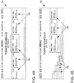
- Figure 4A shows an analog to Figure 2B generated cardless display, in which the information of a calendar of the user is displayed.
- the representation includes appointment objects 24, which are arranged chronologically horizontally.
- the currently current appointment object 24 is shown in the center and enlarged. Further information is also shown on the display surface 1a, here at the upper edge of the display surface 1a.
- a 3-dimensional map is displayed.
- the switch to this form of ad begins as in Figure 4B with the disappearance of the no longer relevant appointment objects 24, which relate to the past, while at the same time 3-dimensional representations of buildings 26 are built up in the left area of the display area 1a.
- an animation can be shown in which the buildings 26 seem to grow from the ground.
- Figure 4C shows the fully constructed 3-dimensional representation of the surroundings of the destination. In particular, this is generated so that it roughly corresponds to the driver's view of his real environment. Furthermore, the appointment objects 24 are displayed, and their representation can be changed such that their space requirement is adapted to the space requirement for the 3-dimensional map representation.
- FIG. 4D The example shown is determined based on the data of the appointment to which the user is on the way is. This includes information about the floor of the meeting room.
- the external server 3 collects data about the destination and its surroundings and it is displayed in a detailed view of the destination building 26a at the destination, which includes information about where the entrance 29 is located, whether there is an elevator 28 and on which destination floor 27 the meeting room is located. To make these details easier to see, the target building 26a is shown at the destination from a perspective just before it.
Landscapes
- Engineering & Computer Science (AREA)
- Radar, Positioning & Navigation (AREA)
- Remote Sensing (AREA)
- Automation & Control Theory (AREA)
- Physics & Mathematics (AREA)
- General Physics & Mathematics (AREA)
- Navigation (AREA)
Claims (10)
- Procédé de navigation vers une destination, dans lequel
en fonction de la position actuelle et de la destination, des indications de guidage sont affichées sur un écran (1) dans une représentation sans carte avec la représentation d'un calendrier électronique, dans laquelle des instructions de direction sont affichées sans qu'elles ne soient en rapport avec une représentation par carte,
moyennant quoi,
lorsque la position actuelle se trouve à l'intérieur d'un environnement déterminé de la destination, des dernières indications de guidage sont affichées avant la destination automatiquement dans une représentation de carte tridimensionnelle, moyennant quoi, lors de l'entrée dans l'environnement, un changement vers la représentation de carte tridimensionnelle est effectué, les dernières indications de guidage présentant un niveau de détail plus élevé que les indications de guidage et
d'autres indications de guidage sont affichées sur la représentation de carte tridimensionnelle lorsque la destination est affichée sur la représentation de carte tridimensionnelle, les autres indications de guidage reposant sur des données du calendrier électronique. - Procédé selon la revendication 1,
caractérisé en ce que
les autres indications de guidage concernent une ou plusieurs caractéristiques dans la liste suivante : bâtiment (26, 26a), étage (27), ascenseur (28), salle, escalier, couloir, entrée (29). - Procédé selon la revendication 1,
caractérisé en ce que
les données du calendrier électronique comprennent au moins un rendez-vous et en ce qu'au moins un objet graphique (24) est généré et affiché, qui concerne le rendez-vous. - Procédé selon la revendication 1 ou 3,
caractérisé en ce que
les données du calendrier électronique sont relevées par un appareil utilisateur mobile (5) et/ou par un serveur externe (4). - Procédé selon l'une des revendications précédentes,
caractérisé en ce que
la représentation de carte tridimensionnelle comprend au moins une représentation d'un bâtiment (26, 26a). - Procédé selon la revendication 5,
caractérisé en ce que
la représentation du bâtiment (26, 26a) comprend au moins une mise en valeur graphique ou un marquage. - Procédé selon l'une des revendications précédentes,
caractérisé en ce que
les dernières indications de guidage sont relevées par un serveur externe (4). - Dispositif de navigation vers une destination avec
un écran (1),
un dispositif de détermination de position (2) et
une commande (3), qui est conçue pour afficher des indications de guidage à l'écran (1) en fonction de la position actuelle et de la destination,
caractérisé en ce que
la commande (3) est conçue
pour afficher les indications de guidage dans une représentation sans carte avec la représentation d'un calendrier électronique, dans laquelle des instructions de direction sont affichées, sans qu'elles ne soient liées à une représentation de carte,
pour afficher des dernières indications de direction avant la destination automatiquement dans une représentation de carte tridimensionnelle lorsque la position actuelle se trouve à l'intérieur d'un environnement déterminé de la destination, moyennant quoi, lors de l'entrée dans l'environnement, un changement vers la représentation de carte tridimensionnelle est effectué, les dernières indications de guidage présentant un niveau de détail plus élevé que les indications de guidage et
pour afficher d'autres indications de guidage dans la représentation de carte tridimensionnelle lorsque la destination est affichée dans la représentation de carte tridimensionnelle, les dernières indications de guidage reposant sur des données du calendrier électronique. - Dispositif selon la revendication 8,
caractérisé en ce que
les autres indications de guidage concernent une ou plusieurs caractéristiques dans la liste suivante : bâtiment (26, 26a), étage (27), ascenseur (28), salle, escalier, couloir, entrée (29). - Dispositif selon la revendication 9,
caractérisé en ce que
au moins temporairement une liaison peut être établie avec un appareil utilisateur mobile (5) et/ou avec un serveur externe (24) et en ce que les données du calendrier électronique peuvent être relevées par l'appareil utilisateur mobile (5) ou par le serveur externe (4).
Applications Claiming Priority (1)
| Application Number | Priority Date | Filing Date | Title |
|---|---|---|---|
| DE102015206979 | 2015-04-17 |
Publications (3)
| Publication Number | Publication Date |
|---|---|
| EP3081904A2 EP3081904A2 (fr) | 2016-10-19 |
| EP3081904A3 EP3081904A3 (fr) | 2017-03-01 |
| EP3081904B1 true EP3081904B1 (fr) | 2020-01-08 |
Family
ID=54540974
Family Applications (1)
| Application Number | Title | Priority Date | Filing Date |
|---|---|---|---|
| EP15194310.7A Active EP3081904B1 (fr) | 2015-04-17 | 2015-11-12 | Procede et dispositif de navigation vers un emplacement cible |
Country Status (1)
| Country | Link |
|---|---|
| EP (1) | EP3081904B1 (fr) |
Families Citing this family (2)
| Publication number | Priority date | Publication date | Assignee | Title |
|---|---|---|---|---|
| CN110906938A (zh) * | 2018-09-14 | 2020-03-24 | 上海擎感智能科技有限公司 | 地图导航查询方法、系统、介质及设备 |
| US12281911B2 (en) * | 2020-09-04 | 2025-04-22 | Uber Technologies, Inc. | End of route navigation system |
Citations (1)
| Publication number | Priority date | Publication date | Assignee | Title |
|---|---|---|---|---|
| US20120226439A1 (en) * | 2011-03-04 | 2012-09-06 | Hon Hai Precision Industry Co., Ltd. | Navigation device and navigation mode switch method |
Family Cites Families (8)
| Publication number | Priority date | Publication date | Assignee | Title |
|---|---|---|---|---|
| JP4486175B2 (ja) * | 1999-01-29 | 2010-06-23 | 株式会社日立製作所 | 立体地図表示装置および方法 |
| CN1507553A (zh) * | 2001-08-31 | 2004-06-23 | ����Aw��ʽ���� | 信息显示系统 |
| EP2409288A1 (fr) * | 2009-03-16 | 2012-01-25 | Tom Tom Polska SP. Z.O.O. | Procédé de mise à jour de cartes numériques à l'aide d'informations d'altitude |
| DE102011089416A1 (de) | 2011-12-21 | 2013-06-27 | Bayerische Motoren Werke Aktiengesellschaft | Verfahren und Vorrichtung zum automatisierten Ermitteln einer Routenplanung |
| DE102012207412A1 (de) | 2012-05-04 | 2013-08-22 | Siemens Ag | System zur selbsttätigen Wegweisung in einem Objekt, insbesondere einem Gebäude |
| US9392038B2 (en) * | 2012-08-14 | 2016-07-12 | David R. Robinson | Application program and related techniques for organizing a meeting between people |
| DE102013000879A1 (de) * | 2013-01-10 | 2014-07-24 | Volkswagen Aktiengesellschaft | Navigationsvorrichtung für ein bewegliches Objekt und Verfahren zur Erzeugung eines Anzeigesignals für eine Navigationsvorrichtung für ein bewegliches Objekt |
| EP2772726B1 (fr) * | 2013-02-28 | 2019-04-10 | BlackBerry Limited | Indicateur graphique d'emplacement actuel repositionnable |
-
2015
- 2015-11-12 EP EP15194310.7A patent/EP3081904B1/fr active Active
Patent Citations (1)
| Publication number | Priority date | Publication date | Assignee | Title |
|---|---|---|---|---|
| US20120226439A1 (en) * | 2011-03-04 | 2012-09-06 | Hon Hai Precision Industry Co., Ltd. | Navigation device and navigation mode switch method |
Also Published As
| Publication number | Publication date |
|---|---|
| EP3081904A2 (fr) | 2016-10-19 |
| EP3081904A3 (fr) | 2017-03-01 |
Similar Documents
| Publication | Publication Date | Title |
|---|---|---|
| DE102017120613B4 (de) | Verfahren zum Bewegen einer Last mit einem Kran | |
| DE102015213743B4 (de) | Verfahren und System zur automatischen Steuerung zumindest eines Folgefahrzeugs mit einem Scout-Fahrzeug | |
| DE102006015719A1 (de) | Navigationssystem und Programm | |
| DE102007036627A1 (de) | Verfahren zum Betrieb eines Navigationssystems | |
| DE102010045974A1 (de) | Anzeige- und Bedienvorrichtung in einem Kraftfahrzeug | |
| DE102015205133A1 (de) | Verfahren und Vorrichtung zum Ermitteln einer Bewegungsplanung für ein zumindest teilweise automatisiertes Fahren eines Fahrzeugs | |
| DE10023160A1 (de) | Kartenanzeigevorrichtung | |
| DE102018218436A1 (de) | Fahrzeugparkassistenz | |
| DE3429882C2 (fr) | ||
| EP2842117A2 (fr) | Procédé de représentation de l'environnement d'un véhicule | |
| EP3655726A1 (fr) | Procédé de détermination d'un lieu de destination différent d'un lieu défini, système et véhicule automobile équipé dudit système | |
| WO2014108387A2 (fr) | Dispositif de navigation d'un véhicule et procédé de création d'un signal d'affichage pour un dispositif de navigation d'un véhicule | |
| EP1508780B1 (fr) | Dispositif de navigation | |
| WO2008125162A1 (fr) | Procédé et système de navigation routière à option d'itinéraire pour éviter des changements de direction risqués | |
| EP2795257B1 (fr) | Dispositif de mémoire et système de navigation | |
| DE102016219764A1 (de) | Verfahren zum Steuern einer Benutzerführung, Navigationsgerät und Kraftfahrzeug mit einem Navigationsgerät | |
| DE102018112156A1 (de) | Informationsanzeigevorrichtung für fahrzeuge | |
| EP3081904A2 (fr) | Procede et dispositif de navigation vers un emplacement cible | |
| EP2622307A1 (fr) | Procédé et dispositif de détermination d'au moins une probabilité de sortie à partir d'un terrain identifiable sur une carte numérique comme un terrain dégagé | |
| DE102021117448A1 (de) | Steuerverfahren für ein teleoperiertes kraftfahrzeug | |
| DE102007030229A1 (de) | Verfahren und Vorrichtung zur verdeckungsarmen Darstellung dicht benachbarter topografischer Objekte in stilisierter Form | |
| DE60005489T2 (de) | Verfahren zur verfügung von navigationsdaten in einem fahrzeug und navigationssystem | |
| DE102012219233A1 (de) | Verfahren und/oder Vorrichtung zur Erfassung und Darstellung einer Fahrzeugplatzauslastung | |
| DE102010042996A1 (de) | Verfahren zur Erstellung und Verwaltung von Orten von Interesse für ein Navigationsgerät | |
| DE102012014455B4 (de) | Verfahren zum Betreiben eines Parkleitsystems und Parkleitsystem |
Legal Events
| Date | Code | Title | Description |
|---|---|---|---|
| PUAI | Public reference made under article 153(3) epc to a published international application that has entered the european phase |
Free format text: ORIGINAL CODE: 0009012 |
|
| AK | Designated contracting states |
Kind code of ref document: A2 Designated state(s): AL AT BE BG CH CY CZ DE DK EE ES FI FR GB GR HR HU IE IS IT LI LT LU LV MC MK MT NL NO PL PT RO RS SE SI SK SM TR |
|
| AX | Request for extension of the european patent |
Extension state: BA ME |
|
| PUAL | Search report despatched |
Free format text: ORIGINAL CODE: 0009013 |
|
| AK | Designated contracting states |
Kind code of ref document: A3 Designated state(s): AL AT BE BG CH CY CZ DE DK EE ES FI FR GB GR HR HU IE IS IT LI LT LU LV MC MK MT NL NO PL PT RO RS SE SI SK SM TR |
|
| AX | Request for extension of the european patent |
Extension state: BA ME |
|
| RIC1 | Information provided on ipc code assigned before grant |
Ipc: G01C 21/36 20060101AFI20170126BHEP |
|
| STAA | Information on the status of an ep patent application or granted ep patent |
Free format text: STATUS: REQUEST FOR EXAMINATION WAS MADE |
|
| 17P | Request for examination filed |
Effective date: 20170901 |
|
| RBV | Designated contracting states (corrected) |
Designated state(s): AL AT BE BG CH CY CZ DE DK EE ES FI FR GB GR HR HU IE IS IT LI LT LU LV MC MK MT NL NO PL PT RO RS SE SI SK SM TR |
|
| STAA | Information on the status of an ep patent application or granted ep patent |
Free format text: STATUS: EXAMINATION IS IN PROGRESS |
|
| 17Q | First examination report despatched |
Effective date: 20180829 |
|
| GRAP | Despatch of communication of intention to grant a patent |
Free format text: ORIGINAL CODE: EPIDOSNIGR1 |
|
| STAA | Information on the status of an ep patent application or granted ep patent |
Free format text: STATUS: GRANT OF PATENT IS INTENDED |
|
| INTG | Intention to grant announced |
Effective date: 20190829 |
|
| GRAS | Grant fee paid |
Free format text: ORIGINAL CODE: EPIDOSNIGR3 |
|
| GRAA | (expected) grant |
Free format text: ORIGINAL CODE: 0009210 |
|
| STAA | Information on the status of an ep patent application or granted ep patent |
Free format text: STATUS: THE PATENT HAS BEEN GRANTED |
|
| AK | Designated contracting states |
Kind code of ref document: B1 Designated state(s): AL AT BE BG CH CY CZ DE DK EE ES FI FR GB GR HR HU IE IS IT LI LT LU LV MC MK MT NL NO PL PT RO RS SE SI SK SM TR |
|
| REG | Reference to a national code |
Ref country code: GB Ref legal event code: FG4D Free format text: NOT ENGLISH |
|
| REG | Reference to a national code |
Ref country code: CH Ref legal event code: EP |
|
| REG | Reference to a national code |
Ref country code: DE Ref legal event code: R096 Ref document number: 502015011447 Country of ref document: DE |
|
| REG | Reference to a national code |
Ref country code: IE Ref legal event code: FG4D Free format text: LANGUAGE OF EP DOCUMENT: GERMAN |
|
| REG | Reference to a national code |
Ref country code: AT Ref legal event code: REF Ref document number: 1223250 Country of ref document: AT Kind code of ref document: T Effective date: 20200215 |
|
| REG | Reference to a national code |
Ref country code: NL Ref legal event code: MP Effective date: 20200108 |
|
| REG | Reference to a national code |
Ref country code: LT Ref legal event code: MG4D |
|
| PG25 | Lapsed in a contracting state [announced via postgrant information from national office to epo] |
Ref country code: FI Free format text: LAPSE BECAUSE OF FAILURE TO SUBMIT A TRANSLATION OF THE DESCRIPTION OR TO PAY THE FEE WITHIN THE PRESCRIBED TIME-LIMIT Effective date: 20200108 Ref country code: NO Free format text: LAPSE BECAUSE OF FAILURE TO SUBMIT A TRANSLATION OF THE DESCRIPTION OR TO PAY THE FEE WITHIN THE PRESCRIBED TIME-LIMIT Effective date: 20200408 Ref country code: NL Free format text: LAPSE BECAUSE OF FAILURE TO SUBMIT A TRANSLATION OF THE DESCRIPTION OR TO PAY THE FEE WITHIN THE PRESCRIBED TIME-LIMIT Effective date: 20200108 Ref country code: LT Free format text: LAPSE BECAUSE OF FAILURE TO SUBMIT A TRANSLATION OF THE DESCRIPTION OR TO PAY THE FEE WITHIN THE PRESCRIBED TIME-LIMIT Effective date: 20200108 Ref country code: RS Free format text: LAPSE BECAUSE OF FAILURE TO SUBMIT A TRANSLATION OF THE DESCRIPTION OR TO PAY THE FEE WITHIN THE PRESCRIBED TIME-LIMIT Effective date: 20200108 Ref country code: PT Free format text: LAPSE BECAUSE OF FAILURE TO SUBMIT A TRANSLATION OF THE DESCRIPTION OR TO PAY THE FEE WITHIN THE PRESCRIBED TIME-LIMIT Effective date: 20200531 |
|
| PG25 | Lapsed in a contracting state [announced via postgrant information from national office to epo] |
Ref country code: BG Free format text: LAPSE BECAUSE OF FAILURE TO SUBMIT A TRANSLATION OF THE DESCRIPTION OR TO PAY THE FEE WITHIN THE PRESCRIBED TIME-LIMIT Effective date: 20200408 Ref country code: HR Free format text: LAPSE BECAUSE OF FAILURE TO SUBMIT A TRANSLATION OF THE DESCRIPTION OR TO PAY THE FEE WITHIN THE PRESCRIBED TIME-LIMIT Effective date: 20200108 Ref country code: GR Free format text: LAPSE BECAUSE OF FAILURE TO SUBMIT A TRANSLATION OF THE DESCRIPTION OR TO PAY THE FEE WITHIN THE PRESCRIBED TIME-LIMIT Effective date: 20200409 Ref country code: IS Free format text: LAPSE BECAUSE OF FAILURE TO SUBMIT A TRANSLATION OF THE DESCRIPTION OR TO PAY THE FEE WITHIN THE PRESCRIBED TIME-LIMIT Effective date: 20200508 Ref country code: LV Free format text: LAPSE BECAUSE OF FAILURE TO SUBMIT A TRANSLATION OF THE DESCRIPTION OR TO PAY THE FEE WITHIN THE PRESCRIBED TIME-LIMIT Effective date: 20200108 Ref country code: SE Free format text: LAPSE BECAUSE OF FAILURE TO SUBMIT A TRANSLATION OF THE DESCRIPTION OR TO PAY THE FEE WITHIN THE PRESCRIBED TIME-LIMIT Effective date: 20200108 |
|
| REG | Reference to a national code |
Ref country code: DE Ref legal event code: R097 Ref document number: 502015011447 Country of ref document: DE |
|
| PG25 | Lapsed in a contracting state [announced via postgrant information from national office to epo] |
Ref country code: ES Free format text: LAPSE BECAUSE OF FAILURE TO SUBMIT A TRANSLATION OF THE DESCRIPTION OR TO PAY THE FEE WITHIN THE PRESCRIBED TIME-LIMIT Effective date: 20200108 Ref country code: CZ Free format text: LAPSE BECAUSE OF FAILURE TO SUBMIT A TRANSLATION OF THE DESCRIPTION OR TO PAY THE FEE WITHIN THE PRESCRIBED TIME-LIMIT Effective date: 20200108 Ref country code: RO Free format text: LAPSE BECAUSE OF FAILURE TO SUBMIT A TRANSLATION OF THE DESCRIPTION OR TO PAY THE FEE WITHIN THE PRESCRIBED TIME-LIMIT Effective date: 20200108 Ref country code: SK Free format text: LAPSE BECAUSE OF FAILURE TO SUBMIT A TRANSLATION OF THE DESCRIPTION OR TO PAY THE FEE WITHIN THE PRESCRIBED TIME-LIMIT Effective date: 20200108 Ref country code: EE Free format text: LAPSE BECAUSE OF FAILURE TO SUBMIT A TRANSLATION OF THE DESCRIPTION OR TO PAY THE FEE WITHIN THE PRESCRIBED TIME-LIMIT Effective date: 20200108 Ref country code: SM Free format text: LAPSE BECAUSE OF FAILURE TO SUBMIT A TRANSLATION OF THE DESCRIPTION OR TO PAY THE FEE WITHIN THE PRESCRIBED TIME-LIMIT Effective date: 20200108 Ref country code: DK Free format text: LAPSE BECAUSE OF FAILURE TO SUBMIT A TRANSLATION OF THE DESCRIPTION OR TO PAY THE FEE WITHIN THE PRESCRIBED TIME-LIMIT Effective date: 20200108 |
|
| PLBE | No opposition filed within time limit |
Free format text: ORIGINAL CODE: 0009261 |
|
| STAA | Information on the status of an ep patent application or granted ep patent |
Free format text: STATUS: NO OPPOSITION FILED WITHIN TIME LIMIT |
|
| 26N | No opposition filed |
Effective date: 20201009 |
|
| PG25 | Lapsed in a contracting state [announced via postgrant information from national office to epo] |
Ref country code: IT Free format text: LAPSE BECAUSE OF FAILURE TO SUBMIT A TRANSLATION OF THE DESCRIPTION OR TO PAY THE FEE WITHIN THE PRESCRIBED TIME-LIMIT Effective date: 20200108 |
|
| PG25 | Lapsed in a contracting state [announced via postgrant information from national office to epo] |
Ref country code: SI Free format text: LAPSE BECAUSE OF FAILURE TO SUBMIT A TRANSLATION OF THE DESCRIPTION OR TO PAY THE FEE WITHIN THE PRESCRIBED TIME-LIMIT Effective date: 20200108 Ref country code: PL Free format text: LAPSE BECAUSE OF FAILURE TO SUBMIT A TRANSLATION OF THE DESCRIPTION OR TO PAY THE FEE WITHIN THE PRESCRIBED TIME-LIMIT Effective date: 20200108 |
|
| PG25 | Lapsed in a contracting state [announced via postgrant information from national office to epo] |
Ref country code: MC Free format text: LAPSE BECAUSE OF FAILURE TO SUBMIT A TRANSLATION OF THE DESCRIPTION OR TO PAY THE FEE WITHIN THE PRESCRIBED TIME-LIMIT Effective date: 20200108 |
|
| REG | Reference to a national code |
Ref country code: CH Ref legal event code: PL |
|
| PG25 | Lapsed in a contracting state [announced via postgrant information from national office to epo] |
Ref country code: LU Free format text: LAPSE BECAUSE OF NON-PAYMENT OF DUE FEES Effective date: 20201112 |
|
| REG | Reference to a national code |
Ref country code: BE Ref legal event code: MM Effective date: 20201130 |
|
| PG25 | Lapsed in a contracting state [announced via postgrant information from national office to epo] |
Ref country code: LI Free format text: LAPSE BECAUSE OF NON-PAYMENT OF DUE FEES Effective date: 20201130 Ref country code: CH Free format text: LAPSE BECAUSE OF NON-PAYMENT OF DUE FEES Effective date: 20201130 |
|
| PG25 | Lapsed in a contracting state [announced via postgrant information from national office to epo] |
Ref country code: IE Free format text: LAPSE BECAUSE OF NON-PAYMENT OF DUE FEES Effective date: 20201112 |
|
| REG | Reference to a national code |
Ref country code: AT Ref legal event code: MM01 Ref document number: 1223250 Country of ref document: AT Kind code of ref document: T Effective date: 20201112 |
|
| PG25 | Lapsed in a contracting state [announced via postgrant information from national office to epo] |
Ref country code: AT Free format text: LAPSE BECAUSE OF NON-PAYMENT OF DUE FEES Effective date: 20201112 |
|
| PG25 | Lapsed in a contracting state [announced via postgrant information from national office to epo] |
Ref country code: TR Free format text: LAPSE BECAUSE OF FAILURE TO SUBMIT A TRANSLATION OF THE DESCRIPTION OR TO PAY THE FEE WITHIN THE PRESCRIBED TIME-LIMIT Effective date: 20200108 Ref country code: MT Free format text: LAPSE BECAUSE OF FAILURE TO SUBMIT A TRANSLATION OF THE DESCRIPTION OR TO PAY THE FEE WITHIN THE PRESCRIBED TIME-LIMIT Effective date: 20200108 Ref country code: CY Free format text: LAPSE BECAUSE OF FAILURE TO SUBMIT A TRANSLATION OF THE DESCRIPTION OR TO PAY THE FEE WITHIN THE PRESCRIBED TIME-LIMIT Effective date: 20200108 |
|
| PG25 | Lapsed in a contracting state [announced via postgrant information from national office to epo] |
Ref country code: MK Free format text: LAPSE BECAUSE OF FAILURE TO SUBMIT A TRANSLATION OF THE DESCRIPTION OR TO PAY THE FEE WITHIN THE PRESCRIBED TIME-LIMIT Effective date: 20200108 Ref country code: AL Free format text: LAPSE BECAUSE OF FAILURE TO SUBMIT A TRANSLATION OF THE DESCRIPTION OR TO PAY THE FEE WITHIN THE PRESCRIBED TIME-LIMIT Effective date: 20200108 |
|
| PG25 | Lapsed in a contracting state [announced via postgrant information from national office to epo] |
Ref country code: BE Free format text: LAPSE BECAUSE OF NON-PAYMENT OF DUE FEES Effective date: 20201130 |
|
| P01 | Opt-out of the competence of the unified patent court (upc) registered |
Effective date: 20230523 |
|
| PGFP | Annual fee paid to national office [announced via postgrant information from national office to epo] |
Ref country code: DE Payment date: 20251130 Year of fee payment: 11 |
|
| PGFP | Annual fee paid to national office [announced via postgrant information from national office to epo] |
Ref country code: GB Payment date: 20251125 Year of fee payment: 11 |
|
| PGFP | Annual fee paid to national office [announced via postgrant information from national office to epo] |
Ref country code: FR Payment date: 20251124 Year of fee payment: 11 |