EP3086294A1 - Système et procédé pour surveillance et contrôle de trafic et enregistrement d'infractions de circulation, et véhicule aérien sans équipage correspondant - Google Patents
Système et procédé pour surveillance et contrôle de trafic et enregistrement d'infractions de circulation, et véhicule aérien sans équipage correspondant Download PDFInfo
- Publication number
- EP3086294A1 EP3086294A1 EP14872300.0A EP14872300A EP3086294A1 EP 3086294 A1 EP3086294 A1 EP 3086294A1 EP 14872300 A EP14872300 A EP 14872300A EP 3086294 A1 EP3086294 A1 EP 3086294A1
- Authority
- EP
- European Patent Office
- Prior art keywords
- unmanned aerial
- aerial vehicle
- speed
- vehicle
- roadway
- Prior art date
- Legal status (The legal status is an assumption and is not a legal conclusion. Google has not performed a legal analysis and makes no representation as to the accuracy of the status listed.)
- Granted
Links
Images

Classifications
-
- G—PHYSICS
- G08—SIGNALLING
- G08G—TRAFFIC CONTROL SYSTEMS
- G08G1/00—Traffic control systems for road vehicles
- G08G1/01—Detecting movement of traffic to be counted or controlled
-
- G—PHYSICS
- G01—MEASURING; TESTING
- G01S—RADIO DIRECTION-FINDING; RADIO NAVIGATION; DETERMINING DISTANCE OR VELOCITY BY USE OF RADIO WAVES; LOCATING OR PRESENCE-DETECTING BY USE OF THE REFLECTION OR RERADIATION OF RADIO WAVES; ANALOGOUS ARRANGEMENTS USING OTHER WAVES
- G01S13/00—Systems using the reflection or reradiation of radio waves, e.g. radar systems; Analogous systems using reflection or reradiation of waves whose nature or wavelength is irrelevant or unspecified
- G01S13/88—Radar or analogous systems specially adapted for specific applications
- G01S13/91—Radar or analogous systems specially adapted for specific applications for traffic control
- G01S13/92—Radar or analogous systems specially adapted for specific applications for traffic control for velocity measurement
-
- G—PHYSICS
- G01—MEASURING; TESTING
- G01S—RADIO DIRECTION-FINDING; RADIO NAVIGATION; DETERMINING DISTANCE OR VELOCITY BY USE OF RADIO WAVES; LOCATING OR PRESENCE-DETECTING BY USE OF THE REFLECTION OR RERADIATION OF RADIO WAVES; ANALOGOUS ARRANGEMENTS USING OTHER WAVES
- G01S13/00—Systems using the reflection or reradiation of radio waves, e.g. radar systems; Analogous systems using reflection or reradiation of waves whose nature or wavelength is irrelevant or unspecified
-
- G—PHYSICS
- G01—MEASURING; TESTING
- G01S—RADIO DIRECTION-FINDING; RADIO NAVIGATION; DETERMINING DISTANCE OR VELOCITY BY USE OF RADIO WAVES; LOCATING OR PRESENCE-DETECTING BY USE OF THE REFLECTION OR RERADIATION OF RADIO WAVES; ANALOGOUS ARRANGEMENTS USING OTHER WAVES
- G01S13/00—Systems using the reflection or reradiation of radio waves, e.g. radar systems; Analogous systems using reflection or reradiation of waves whose nature or wavelength is irrelevant or unspecified
- G01S13/02—Systems using reflection of radio waves, e.g. primary radar systems; Analogous systems
- G01S13/50—Systems of measurement based on relative movement of target
-
- G—PHYSICS
- G01—MEASURING; TESTING
- G01S—RADIO DIRECTION-FINDING; RADIO NAVIGATION; DETERMINING DISTANCE OR VELOCITY BY USE OF RADIO WAVES; LOCATING OR PRESENCE-DETECTING BY USE OF THE REFLECTION OR RERADIATION OF RADIO WAVES; ANALOGOUS ARRANGEMENTS USING OTHER WAVES
- G01S13/00—Systems using the reflection or reradiation of radio waves, e.g. radar systems; Analogous systems using reflection or reradiation of waves whose nature or wavelength is irrelevant or unspecified
- G01S13/86—Combinations of radar systems with non-radar systems, e.g. sonar, direction finder
- G01S13/867—Combination of radar systems with cameras
-
- G—PHYSICS
- G01—MEASURING; TESTING
- G01S—RADIO DIRECTION-FINDING; RADIO NAVIGATION; DETERMINING DISTANCE OR VELOCITY BY USE OF RADIO WAVES; LOCATING OR PRESENCE-DETECTING BY USE OF THE REFLECTION OR RERADIATION OF RADIO WAVES; ANALOGOUS ARRANGEMENTS USING OTHER WAVES
- G01S13/00—Systems using the reflection or reradiation of radio waves, e.g. radar systems; Analogous systems using reflection or reradiation of waves whose nature or wavelength is irrelevant or unspecified
- G01S13/88—Radar or analogous systems specially adapted for specific applications
- G01S13/91—Radar or analogous systems specially adapted for specific applications for traffic control
-
- G—PHYSICS
- G01—MEASURING; TESTING
- G01S—RADIO DIRECTION-FINDING; RADIO NAVIGATION; DETERMINING DISTANCE OR VELOCITY BY USE OF RADIO WAVES; LOCATING OR PRESENCE-DETECTING BY USE OF THE REFLECTION OR RERADIATION OF RADIO WAVES; ANALOGOUS ARRANGEMENTS USING OTHER WAVES
- G01S7/00—Details of systems according to groups G01S13/00, G01S15/00, G01S17/00
- G01S7/003—Transmission of data between radar, sonar or lidar systems and remote stations
-
- G—PHYSICS
- G06—COMPUTING OR CALCULATING; COUNTING
- G06F—ELECTRIC DIGITAL DATA PROCESSING
- G06F17/00—Digital computing or data processing equipment or methods, specially adapted for specific functions
-
- G—PHYSICS
- G06—COMPUTING OR CALCULATING; COUNTING
- G06T—IMAGE DATA PROCESSING OR GENERATION, IN GENERAL
- G06T7/00—Image analysis
- G06T7/20—Analysis of motion
-
- G—PHYSICS
- G06—COMPUTING OR CALCULATING; COUNTING
- G06V—IMAGE OR VIDEO RECOGNITION OR UNDERSTANDING
- G06V20/00—Scenes; Scene-specific elements
- G06V20/10—Terrestrial scenes
- G06V20/13—Satellite images
-
- G—PHYSICS
- G06—COMPUTING OR CALCULATING; COUNTING
- G06V—IMAGE OR VIDEO RECOGNITION OR UNDERSTANDING
- G06V20/00—Scenes; Scene-specific elements
- G06V20/50—Context or environment of the image
- G06V20/52—Surveillance or monitoring of activities, e.g. for recognising suspicious objects
-
- G—PHYSICS
- G07—CHECKING-DEVICES
- G07B—TICKET-ISSUING APPARATUS; FARE-REGISTERING APPARATUS; FRANKING APPARATUS
- G07B15/00—Arrangements or apparatus for collecting fares, tolls or entrance fees at one or more control points
- G07B15/06—Arrangements for road pricing or congestion charging of vehicles or vehicle users, e.g. automatic toll systems
-
- G—PHYSICS
- G08—SIGNALLING
- G08G—TRAFFIC CONTROL SYSTEMS
- G08G1/00—Traffic control systems for road vehicles
-
- G—PHYSICS
- G08—SIGNALLING
- G08G—TRAFFIC CONTROL SYSTEMS
- G08G1/00—Traffic control systems for road vehicles
- G08G1/01—Detecting movement of traffic to be counted or controlled
- G08G1/052—Detecting movement of traffic to be counted or controlled with provision for determining speed or overspeed
- G08G1/054—Detecting movement of traffic to be counted or controlled with provision for determining speed or overspeed photographing overspeeding vehicles
-
- G—PHYSICS
- G08—SIGNALLING
- G08G—TRAFFIC CONTROL SYSTEMS
- G08G5/00—Traffic control systems for aircraft
- G08G5/50—Navigation or guidance aids
- G08G5/55—Navigation or guidance aids for a single aircraft
-
- G—PHYSICS
- G08—SIGNALLING
- G08G—TRAFFIC CONTROL SYSTEMS
- G08G5/00—Traffic control systems for aircraft
- G08G5/50—Navigation or guidance aids
- G08G5/57—Navigation or guidance aids for unmanned aircraft
-
- H—ELECTRICITY
- H04—ELECTRIC COMMUNICATION TECHNIQUE
- H04N—PICTORIAL COMMUNICATION, e.g. TELEVISION
- H04N7/00—Television systems
- H04N7/18—Closed-circuit television [CCTV] systems, i.e. systems in which the video signal is not broadcast
- H04N7/181—Closed-circuit television [CCTV] systems, i.e. systems in which the video signal is not broadcast for receiving images from a plurality of remote sources
-
- B—PERFORMING OPERATIONS; TRANSPORTING
- B64—AIRCRAFT; AVIATION; COSMONAUTICS
- B64U—UNMANNED AERIAL VEHICLES [UAV]; EQUIPMENT THEREFOR
- B64U2101/00—UAVs specially adapted for particular uses or applications
- B64U2101/30—UAVs specially adapted for particular uses or applications for imaging, photography or videography
- B64U2101/31—UAVs specially adapted for particular uses or applications for imaging, photography or videography for surveillance
-
- G—PHYSICS
- G06—COMPUTING OR CALCULATING; COUNTING
- G06T—IMAGE DATA PROCESSING OR GENERATION, IN GENERAL
- G06T2207/00—Indexing scheme for image analysis or image enhancement
- G06T2207/30—Subject of image; Context of image processing
- G06T2207/30232—Surveillance
-
- G—PHYSICS
- G06—COMPUTING OR CALCULATING; COUNTING
- G06T—IMAGE DATA PROCESSING OR GENERATION, IN GENERAL
- G06T2207/00—Indexing scheme for image analysis or image enhancement
- G06T2207/30—Subject of image; Context of image processing
- G06T2207/30236—Traffic on road, railway or crossing
Definitions
- the present invention relates to the field of traffic monitoring and surveillance and traffic infraction recording systems.
- the present invention relates to a system and method for the detection of a traffic infraction, speed measurement of the offending vehicle and recording of image and/or video of the offending vehicle.
- the invention relates to an unmanned aerial vehicle (UAV) capable of implementing the method according to the invention.
- UAV unmanned aerial vehicle
- the state of the art comprises the most diverse solutions to traffic control by using devices capable of monitoring, supervising and recording infractions, given that, in recent years, there has been an increase in the use of vehicles for the implementation of these tasks, including moving vehicles and unmanned aerial vehicles.
- US patent document US 2010/0328140 discloses a traffic surveillance system using a Doppler radar consisting of a system which comprises three Doppler antennas for detection and recording of vehicle images. It provides for the installation of the surveillance system next to the highway or embedded in an unmanned aerial vehicle, wherein this possibility of using it embedded is only mentioned, lacking sufficient description.
- US patent document US 2010/0291876 discloses a traffic surveillance system using a Doppler radar consisting of a system which comprises three Doppler antennas for detection and calculation of vehicle speed. It provides for the installation of the surveillance system next to the highway or embedded in an unmanned aerial vehicle, wherein this possibility of using it embedded is only mentioned, lacking sufficient description - just as the case of US patent document US 2010/0328140 .
- Document DE 10 2005 002 278 discloses a method of land surveillance and aircraft for the implementation thereof, wherein said unmanned aerial vehicle monitors the terrain with a camera, comparing each new image taken to previous or preprogrammed situations, sending alarms when the situation of the new image differs from the previous or preprogrammed image. There isn't the description or disclosure of the verification and subsequent validation of the maximum speed permitted on the monitored section, let alone of the monitoring and surveillance in sections having variable speed limits, especially in the transition regions between said sections.
- DE 10 2005 002 278 also doesn't mention the compensation of the measured speed with respect to the speed of the unmanned aerial vehicle.
- Document CN102436738 discloses a traffic monitoring device based on an unmanned aerial vehicle, capable of detecting an infraction of speeding, wherein the monitored vehicle speed is calculated by analyzing the amount of frames or camera frames; that is, it does not have the proper precision for measuring speed reliably enough to serve as the basis for a document of infraction. Also, CN102436738 does not disclose how the information of the speed limit that delimits monitoring is obtained, therefore, being intended to attainment of traffic information and retrieval of video, but not to electronic monitoring itself. There isn't the description of the monitoring and surveillance in sections having variable speed limits, let alone of any form of compensation of measured speed with respect to the speed of the unmanned aerial vehicle.
- one of the objectives of the invention is a system according to the features of independent claim 1.
- Another objective of the invention is a method according to the features of independent claim 10.
- Another objective of the invention is an unmanned aerial vehicle according to the features of independent claim 18 and an unmanned aerial vehicle according to the features of independent claim 19. Further details of these features and/or additional features are represented by the corresponding dependent claims.
- a method of traffic monitoring and surveillance and traffic infraction recording comprises the steps of localization, detection, measurement, comparison, capture, storage and transmission.
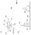
- the system according to the invention is provided with an unmanned aerial vehicle (10) and a base station (80), wherein said unmanned aerial vehicle (10) moves in the airspace (200) and the base station (80) is on the ground (300).
- the unmanned aerial vehicle (10) is provided with one or more self-propelled devices (20), at least one detector and speed meter (30), one or more cameras (40), an embedded central unit (50), at least one device provided with a global positioning system or GPS (60) and at least one signal transmission and reception device (70).
- Self-propelled devices (20) allow for the support and the drag of the unmanned aerial vehicle (10) and its positioning within the airspace (200).
- the detector and speed meter (30) is a tracking sensor ( tracking antenna ), preferably Doppler-type, which detects the vehicle (120) and calculates its relative speed (V MED ) and displacement direction at a given point of the roadway (300), below the location of the unmanned aerial vehicle (10).
- One or more cameras (40) are responsible for the capture of images/videos of the vehicle (120), wherein said cameras are stabilized, preferably, by one or more balancers or gimbals, to ensure the capture of legible images/videos of the vehicle (120).
- the embedded central unit (50) is provided with a central processing unit or CPU (50a), an embedded storage device (50b), eventually an embedded database (50c) and eventually an embedded map (50d).
- a central processing unit or CPU 50a
- an embedded storage device 50b
- an embedded database 50c
- an embedded map 50d
- the central processing unit or CPU (50a) controls the detector and speed meter (30), the camera (s) (40), GPS (60), the signal transmission and reception device (70), and also executes the method object of this patent.
- the embedded storage device (50b) temporarily stores the images/videos of vehicles (120) captured by the cameras (40), the database of speeds regulated by location and vector maps of the roadways (300) to be surveilled in the unmanned aerial vehicle (10).
- the images/videos remain in this embedded storage device (50b) up until transmission to the base station (80) or to the collection of the embedded storage device iteself (50b) when the unmanned aerial vehicle (10) is on the ground.
- the device provided with global positioning system or GPS (60) allows for the determination of the location, ground speed (V D ) and the direction of the unmanned aerial vehicle (10) within the airspace (200), in a manner known in the state of the art.
- the speed meter (30) or tracking sensor or tracking antenna makes the correlation between the position of the unmanned aerial vehicle (10) and the position of the vehicle (120) for the purposes of determining the location (1 st step of exemplary method above) that, in the case of an unmanned aerial vehicle (10) is, just like 4th step, obviously variable.
- the signal transmission and reception device (70) enables communication between the unmanned aerial vehicle (10) and the base station (80), in a manner known in the state of the art.
- the base station (80) is provided with at least one control module (90), at least one storage device of images and/or video (100) and at least one signal transmission and reception device (110).
- the base station (80) is preferentially on the ground (300), given that, depending on the type of application, the base station (80) can be found over a base vehicle (not represented).
- the base station (80) is provided with access to a remote central database (online update) and may also have a database in its physical structure (periodic update).
- said central database or data bank contains and provides, among others, relevant traffic information including information on the maximum speeds permitted by sections, maps and other related information.
- control module (90) remotely performs the operation of flight of the unmanned aerial vehicle (10), being responsible for the programming of that flight, or even instantaneous control of the trajectory of the unmanned aerial vehicle (10), in a manner known in the state of the art.
- the storage device of images and/or video (100) stores the images/videos of vehicles captured by unmanned aerial vehicle (10) in the base station (80), in a manner known in the state of the art.
- the unmanned aerial vehicle (10) is controlled/monitored remotely from the base station (80) and maintained within the airspace (200) that is defined, for example, by legal and/or functional provisions and/or the autonomy and/or the range of signal transmission and reception devices (70, 110), as known in the state of the art.
- the system consisting of unmanned aerial vehicle (10) and base station (80) serves to the monitoring and surveillance of one or more vehicles (120) moving on one or more roadways (300), thus, said system serving to the activity of detection and recording of image and/or video of speeding infractions by vehicles (120) moving on said monitored roadway (300).
- the monitoring and surveillance of the speed of a vehicle (120) on a roadway (300) aim at monitoring the speed of the vehicle (120) and the subsequent and eventual capture of image and/or video of said vehicle (120) should an infraction occur, i.e. speeding.
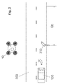
- the operation of the system according to the invention begins with the takeoff of the unmanned aerial vehicle (10) and the positioning of the latter in the airspace (200) above or near the roadway (300), which can be seen in an exemplary and non-limiting manner in Figure 2 .
- the location, ground speed (V D ) and the direction of the unmanned aerial vehicle (10) is performed by using the embedded GPS device (60) and the correlation between the position of the unmanned aerial vehicle (10) and the position of the vehicle (120) for the purpose of location determination is performed by the speed meter (30) or tracking sensor or tracking antenna.
- an embedded database (5 c) of the unmanned aerial vehicle itself (10) or available on or from the base station (80) is queried for the verification of the maximum speed allowed for that roadway (300) below the position of the unmanned aerial vehicle (10) or for the roadway (300) target of monitoring on the section the vehicle (120) can be found.
- vehicle (120) When a vehicle (120) enters the measuring beam of the detector and speed meter (30), this vehicle (120) shall be monitored. At least the following data are informed by the detector and speed meter (30) to the central processing unit (50a): vehicle (120) identifier, vector of vehicle (120) speeds, and vehicle (120) position vector.
- V MED relative speed
- the method according to the invention considers variable a 1st step and changes substantially the 4th step of the exemplary method mentioned above, thus validating the trigger before capture (5th step) of the image.
- the unmanned aerial vehicle (10) in addition to the information on maximum limit permitted for a given location, there is the verification in the embedded database (50c) of the unmanned aerial vehicle itself (10) or available in or from the base station (80), as to if the unmanned aerial vehicle (10) is in a location near a region of variation of maximum permitted speed, i.e. when the maximum permitted speed is not constant along the entire length of the roadway (300).
- Dp perception, reaction and braking distance
- the query performed to the embedded database (50c) or to a databank presents the maximum speed permitted on the section initially travelled by the vehicle (120) and the maximum speed permitted in the subsequent section.
- Dp perception, reaction and braking distance
- Dp perception, reaction and braking distance
- Another calculation method is the one anticipated, for example, by A Policy on Geometric Design of Highways and Streets, of the American Association of State Highway Officials (AASHTO) - AASHTO, 2004, pages 117-118 , or, for example, by Recommandations techniques pour la conception inevitable et la géometrie de la route.
- Aménagement des Routes Principales of the Service d'Études Techniques des Routes ET Autoroutes (SETRA) - SETRA, 1994, pages 76-77 , or even by Compense les Principaux Paraplace de Conception Géométrique des Routes of the Service d'Études Techniques des Routes ET Autoroutes (SÉTRA) - SETRA, 2006, pages 6-7 .
- the GPS (60) indicated the location of the unmanned aerial vehicle (10) above or near a region between the speed transition point (signpost (310)) and the distance equal to the perception, reaction and braking distance (Dp), the record of the infraction cannot be used as a proof of traffic infraction.
- the verification method of perception, reaction and braking distance (Dp) aims to generate a coordinate of the roadway (300) from which a possible violation must be considered, respecting the corresponding legislation and preventing the generation of invalid records of infractions.
- the method according to the invention considers variable a 1st step and changes substantially the 4th step of the exemplary method mentioned above, thus validating the trigger before capture (5th step) of the image, considering the perception, reaction and braking distance (Dp) corresponding to the location.
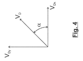
- V D Information of ground speed (V D ) and of direction of the unmanned aerial vehicle (10) is used to calculate the vehicle speed (Vv) on the roadway (300), should the unmanned aerial vehicle (10) be in motion at the time of measurement.
- the detector and speed meter (30) of the unmanned aerial vehicle (10) is a Doppler tracking sensor (tracking antenna), which detects the vehicle (120) and calculates its relative speed (V MED ) and displacement direction at a given point of the roadway (300), below the location of the unmanned aerial vehicle (10).
- V MED relative speed
- Figure 3 illustrates a hypothetical situation in which the unmanned aerial vehicle (10) has a speed (V D ) in an inclined direction by relative angle ( ⁇ ) in relation to imaginary axes (x) and (y) of the horizontal plane in which the roadway (300) is found, while the vehicle (120) moves in the x direction with a speed (V v ).
- Vv V MED ⁇ V Dx
- Vv V MED + V Dx
- the camera (s) (40) captures/capture images and/or videos which prove the infraction was committed, identifying the offending vehicle based on its license plate.
- Relative angle ( ⁇ ), required for the decomposition of the speed vector, can be determined by calculating the angular coefficients (m) of the lines that describe: the trajectory of the unmanned aerial vehicle (10) and the direction of the roadway.
- the trajectory of the unmanned aerial vehicle is given by the GPS (60), in the form of two shifting points (x D1 , y D1 e x D2 , y D2 ).
- the direction of the roadway is obtained by querying the embedded vectorized map, which provides two points (x via1 , y via1 e x via2 , y via2 ) of the roadway vector in the position below the unmanned aerial vehicle.
- relative angle ( ⁇ ) is calculated by simple subtraction of angles, if the orientation of the roadway orientation (e.g., 30° NE) is available in the embedded map to be used, and GPS offers the option of electronic compass.
- the method according to the invention considers variable the 1 st step and changes substantially the 3rd step of the exemplary method mentioned above.
Landscapes
- Engineering & Computer Science (AREA)
- Physics & Mathematics (AREA)
- Remote Sensing (AREA)
- Radar, Positioning & Navigation (AREA)
- General Physics & Mathematics (AREA)
- Computer Networks & Wireless Communication (AREA)
- Theoretical Computer Science (AREA)
- Multimedia (AREA)
- Electromagnetism (AREA)
- Aviation & Aerospace Engineering (AREA)
- Computer Vision & Pattern Recognition (AREA)
- Signal Processing (AREA)
- Finance (AREA)
- Data Mining & Analysis (AREA)
- Databases & Information Systems (AREA)
- Mathematical Physics (AREA)
- Software Systems (AREA)
- General Engineering & Computer Science (AREA)
- Business, Economics & Management (AREA)
- Astronomy & Astrophysics (AREA)
- Traffic Control Systems (AREA)
Applications Claiming Priority (2)
| Application Number | Priority Date | Filing Date | Title |
|---|---|---|---|
| BR102013033041-8A BR102013033041B1 (pt) | 2013-12-20 | 2013-12-20 | Sistema e método de monitoramento e fiscalização de tráfego e registro de infrações de trânsito e veículo aéreo não tripulado correspondente |
| PCT/BR2014/000430 WO2015089600A1 (fr) | 2013-12-20 | 2014-12-08 | Système et procédé pour surveillance et contrôle de trafic et enregistrement d'infractions de circulation, et véhicule aérien sans équipage correspondant |
Publications (4)
| Publication Number | Publication Date |
|---|---|
| EP3086294A1 true EP3086294A1 (fr) | 2016-10-26 |
| EP3086294A4 EP3086294A4 (fr) | 2017-10-25 |
| EP3086294B1 EP3086294B1 (fr) | 2024-10-02 |
| EP3086294C0 EP3086294C0 (fr) | 2024-10-02 |
Family
ID=53401817
Family Applications (1)
| Application Number | Title | Priority Date | Filing Date |
|---|---|---|---|
| EP14872300.0A Active EP3086294B1 (fr) | 2013-12-20 | 2014-12-08 | Système pour surveillance et contrôle de trafic et enregistrement d'infractions de trafic, et procédé correspondant |
Country Status (7)
| Country | Link |
|---|---|
| US (1) | US10677917B2 (fr) |
| EP (1) | EP3086294B1 (fr) |
| CN (1) | CN106030666B (fr) |
| BR (1) | BR102013033041B1 (fr) |
| IL (1) | IL246306B (fr) |
| MX (1) | MX365125B (fr) |
| WO (1) | WO2015089600A1 (fr) |
Cited By (4)
| Publication number | Priority date | Publication date | Assignee | Title |
|---|---|---|---|---|
| DE102017208337A1 (de) * | 2017-05-17 | 2018-11-22 | Jenoptik Robot Gmbh | Verfahren zum Überwachen eines Fahrzeugs mittels eines unbemannten Luftfahrzeugs, Luftfahrzeug und Anordnung zum Überwachen eines Fahrzeugs |
| CN110515073A (zh) * | 2019-08-19 | 2019-11-29 | 南京慧尔视智能科技有限公司 | 多雷达跨区域组网多目标跟踪识别方法及装置 |
| WO2020141504A1 (fr) | 2019-01-01 | 2020-07-09 | Elta Systems Ltd. | Système, procédé et produit programme informatique pour une détection d'excès de vitesse |
| CN111429593A (zh) * | 2020-03-30 | 2020-07-17 | 长安大学 | 一种用于测试无人车自动通过etc收费站能力的系统及方法 |
Families Citing this family (25)
| Publication number | Priority date | Publication date | Assignee | Title |
|---|---|---|---|---|
| CN106056914B (zh) * | 2016-08-01 | 2019-12-24 | 百度在线网络技术(北京)有限公司 | 交通监测方法及无人驾驶的交通监测车辆 |
| CN106097743A (zh) * | 2016-08-13 | 2016-11-09 | 张选琪 | 车辆识别无人机系统 |
| CN113955108B (zh) * | 2016-08-26 | 2025-04-15 | 索尼公司 | 信息处理装置、其控制方法、移动单元及记录介质 |
| CN106781458B (zh) * | 2016-11-30 | 2019-10-18 | 成都通甲优博科技有限责任公司 | 一种交通事故监控方法及系统 |
| CN106886745B (zh) * | 2016-12-26 | 2019-09-24 | 西北工业大学 | 一种基于实时在线地图生成的无人机侦察方法 |
| WO2018136947A1 (fr) * | 2017-01-23 | 2018-07-26 | Ohio University | Système et procédé de détection et de rapport de cibles par liaisons de données |
| US11010614B2 (en) | 2017-01-26 | 2021-05-18 | Matias Klein | Total property intelligence system |
| DE102017105830B4 (de) | 2017-03-17 | 2019-08-29 | Sku Saale-Kies-Union Gmbh | System und Verfahren zur Dokumentation von Abkippvorgängen auf einer Einlagerungsstätte |
| CN108983806B (zh) * | 2017-06-01 | 2022-09-16 | 菜鸟智能物流控股有限公司 | 区域检测、航线规划数据的生成方法和系统、飞行器 |
| CN107622663A (zh) * | 2017-09-23 | 2018-01-23 | 南京律智诚专利技术开发有限公司 | 一种高速公路应急车道智能监控系统 |
| US10814811B2 (en) * | 2017-09-30 | 2020-10-27 | Physician Electronic Networks, L.L.C. | Collision detection system |
| RU2707666C1 (ru) * | 2018-08-01 | 2019-11-28 | Общество с ограниченной ответственностью "СТИЛСОФТ" | Способы видеофиксации нарушения правил дорожного движения с помощью беспилотного летательного аппарата |
| CN108877241A (zh) * | 2018-08-29 | 2018-11-23 | 深圳市旭发智能科技有限公司 | 一种用于超速车辆跟踪监控的无人机及存储介质 |
| CN109087514A (zh) * | 2018-08-29 | 2018-12-25 | 深圳市旭发智能科技有限公司 | 无人机高速超速处理方法及系统 |
| US10926876B2 (en) * | 2018-10-24 | 2021-02-23 | Here Global B.V. | Traffic control system, controller and method for directing vehicle behavior at a defined spatial location |
| CN109597077B (zh) * | 2019-01-02 | 2023-06-30 | 奇瑞汽车股份有限公司 | 一种基于无人机的探测系统 |
| CN109785671B (zh) * | 2019-02-03 | 2022-01-11 | 中睿通信规划设计有限公司 | 无人机标识报告区告警方法和系统 |
| CN111625014A (zh) * | 2019-02-28 | 2020-09-04 | 上海博泰悦臻电子设备制造有限公司 | 一种无人机控制方法、车载终端及计算机可读存储介质 |
| FR3099753B1 (fr) * | 2019-08-07 | 2021-09-03 | Safran Aircraft Engines | Procede de surveillance, produit programme d’ordinateur, systeme de surveillance et aeronef associes |
| CN110827536B (zh) * | 2019-09-23 | 2021-01-05 | 江苏联成开拓集团有限公司 | 一种基于机器人的智能交通防护方法及其系统 |
| CN111627220B (zh) * | 2020-05-22 | 2021-03-23 | 中国科学院空天信息创新研究院 | 一种用于车辆检测的无人机与地面协同处理系统 |
| RU2739067C1 (ru) * | 2020-06-30 | 2020-12-21 | Федеральное государственное бюджетное учреждение "16 Центральный научно-исследовательский испытательный ордена Красной Звезды институт имени маршала войск связи А.И. Белова" Министерства обороны Российской Федерации | Мобильный комплекс связи и управления |
| CN112258842A (zh) * | 2020-10-26 | 2021-01-22 | 北京百度网讯科技有限公司 | 交通监测方法、装置、设备及存储介质 |
| CN112289032B (zh) * | 2020-11-05 | 2022-01-14 | 浙江点辰航空科技有限公司 | 一种无人机高速公路自动巡检方法 |
| CN114373139A (zh) * | 2022-01-07 | 2022-04-19 | 北京远度互联科技有限公司 | 识别道路违规的方法、装置、电子设备及存储介质 |
Family Cites Families (19)
| Publication number | Priority date | Publication date | Assignee | Title |
|---|---|---|---|---|
| US4591823A (en) * | 1984-05-11 | 1986-05-27 | Horvat George T | Traffic speed surveillance system |
| US5952941A (en) * | 1998-02-20 | 1999-09-14 | I0 Limited Partnership, L.L.P. | Satellite traffic control and ticketing system |
| US6246948B1 (en) * | 1998-12-10 | 2001-06-12 | Ericsson Inc. | Wireless intelligent vehicle speed control or monitoring system and method |
| US7183942B2 (en) * | 2000-01-26 | 2007-02-27 | Origin Technologies Limited | Speed trap detection and warning system |
| US6384740B1 (en) * | 2001-07-30 | 2002-05-07 | Khaled A. Al-Ahmed | Traffic speed surveillance and control system |
| DE102005002278A1 (de) | 2005-01-18 | 2006-07-27 | Diehl Bgt Defence Gmbh & Co. Kg | Verfahren zur Geländeüberwachung und Fluggerät zur Durchführung des Verfahrens |
| US7859392B2 (en) * | 2006-05-22 | 2010-12-28 | Iwi, Inc. | System and method for monitoring and updating speed-by-street data |
| US20100328140A1 (en) | 2008-11-06 | 2010-12-30 | Lang Hong | Video-Doppler-Radar Traffic Surveillance System |
| AU2010205905C1 (en) | 2009-01-15 | 2018-06-14 | Flyneye Pty Ltd | System and method of aerial surveillance |
| US8229362B2 (en) | 2009-05-18 | 2012-07-24 | Motorola Mobility, Inc. | Techniques for reducing noise and interference in wireless communication systems |
| MX346564B (es) * | 2010-04-15 | 2017-03-23 | Zlojutro Milan | Sistema de identificacion y monitoreo de vehiculo. |
| US20110291876A1 (en) | 2010-05-29 | 2011-12-01 | Lang Hong | Doppler-Vision-Radar Traffic Surveillance System |
| CN102073846B (zh) * | 2010-12-15 | 2013-06-05 | 同济大学 | 基于航拍图像的交通信息获取方法 |
| CN102436738B (zh) | 2011-09-26 | 2014-03-05 | 同济大学 | 一种基于无人机的交通监测装置 |
| US20130158847A1 (en) | 2011-12-16 | 2013-06-20 | Continental Automotive Systems, Inc. | Configurable traffic zone control system |
| CN102654940B (zh) * | 2012-05-23 | 2014-05-14 | 上海交通大学 | 基于无人驾驶飞机的交通信息采集系统的信息处理方法 |
| US20130338962A1 (en) * | 2012-06-15 | 2013-12-19 | Jerry Alan Crandall | Motion Event Detection |
| US9070289B2 (en) * | 2013-05-10 | 2015-06-30 | Palo Alto Research Incorporated | System and method for detecting, tracking and estimating the speed of vehicles from a mobile platform |
| CN103413444B (zh) * | 2013-08-26 | 2015-08-19 | 深圳市川大智胜科技发展有限公司 | 一种基于无人机高清视频的交通流调查处理方法 |
-
2013
- 2013-12-20 BR BR102013033041-8A patent/BR102013033041B1/pt active IP Right Grant
-
2014
- 2014-12-08 EP EP14872300.0A patent/EP3086294B1/fr active Active
- 2014-12-08 CN CN201480076031.3A patent/CN106030666B/zh active Active
- 2014-12-08 MX MX2016008116A patent/MX365125B/es active IP Right Grant
- 2014-12-08 US US15/106,018 patent/US10677917B2/en active Active
- 2014-12-08 WO PCT/BR2014/000430 patent/WO2015089600A1/fr not_active Ceased
-
2016
- 2016-06-19 IL IL246306A patent/IL246306B/en unknown
Cited By (5)
| Publication number | Priority date | Publication date | Assignee | Title |
|---|---|---|---|---|
| DE102017208337A1 (de) * | 2017-05-17 | 2018-11-22 | Jenoptik Robot Gmbh | Verfahren zum Überwachen eines Fahrzeugs mittels eines unbemannten Luftfahrzeugs, Luftfahrzeug und Anordnung zum Überwachen eines Fahrzeugs |
| WO2020141504A1 (fr) | 2019-01-01 | 2020-07-09 | Elta Systems Ltd. | Système, procédé et produit programme informatique pour une détection d'excès de vitesse |
| EP3906427A4 (fr) * | 2019-01-01 | 2023-03-29 | Elta Systems Ltd. | Système, procédé et produit programme informatique pour une détection d'excès de vitesse |
| CN110515073A (zh) * | 2019-08-19 | 2019-11-29 | 南京慧尔视智能科技有限公司 | 多雷达跨区域组网多目标跟踪识别方法及装置 |
| CN111429593A (zh) * | 2020-03-30 | 2020-07-17 | 长安大学 | 一种用于测试无人车自动通过etc收费站能力的系统及方法 |
Also Published As
| Publication number | Publication date |
|---|---|
| WO2015089600A1 (fr) | 2015-06-25 |
| IL246306B (en) | 2021-08-31 |
| MX365125B (es) | 2019-05-23 |
| CN106030666A (zh) | 2016-10-12 |
| CA2934301A1 (fr) | 2015-06-25 |
| US20160327645A1 (en) | 2016-11-10 |
| CN106030666B (zh) | 2019-07-23 |
| EP3086294A4 (fr) | 2017-10-25 |
| MX2016008116A (es) | 2017-05-10 |
| BR102013033041B1 (pt) | 2022-02-01 |
| BR102013033041A2 (pt) | 2017-02-14 |
| EP3086294B1 (fr) | 2024-10-02 |
| EP3086294C0 (fr) | 2024-10-02 |
| IL246306A0 (en) | 2016-07-31 |
| US10677917B2 (en) | 2020-06-09 |
Similar Documents
| Publication | Publication Date | Title |
|---|---|---|
| EP3086294B1 (fr) | Système pour surveillance et contrôle de trafic et enregistrement d'infractions de trafic, et procédé correspondant | |
| US12430087B2 (en) | Vehicular information systems and methods | |
| EP3769507B1 (fr) | Cartographie de limites de trafic | |
| JP6658088B2 (ja) | 情報処理装置、プログラム、及び地図データ更新システム | |
| CN102951149A (zh) | 一种用于分析车辆将行驶的道路分段的方法及装置 | |
| CN112074885A (zh) | 车道标志定位 | |
| KR101806663B1 (ko) | 레이더 및 비디오 카메라 일체형 교통정보 측정시스템 | |
| JP7524742B2 (ja) | 船舶航路情報生成システムおよび船舶航路情報生成方法 | |
| US10109191B2 (en) | Method of quickly detecting road distress | |
| JPWO2018143237A1 (ja) | 情報処理装置、サーバ装置、情報処理システム、情報処理方法、およびプログラム | |
| JP7808722B2 (ja) | 情報処理装置、地図データ生成装置、方法及びプログラム | |
| Choi et al. | Low-cost precise vehicle localization using lane endpoints and road signs for highway situations | |
| Gupta et al. | Road grade estimation using crowd-sourced smartphone data | |
| US12602931B2 (en) | Identification of unknown traffic objects | |
| Budhkar et al. | Emerging traffic data collection practices under mixed traffic conditions: Challenges and solutions | |
| Arumugam et al. | The role of sensors in shaping future transportation systems | |
| Tsai et al. | Automated Superelevation Measurement Method Using a Low-Cost Mobile Device: An Efficient, Cost-Effective Approach Toward Intelligent Horizontal Curve Safety Assessment | |
| CA2934301C (fr) | Systeme et procede pour surveillance et controle de trafic et enregistrement d'infractions de circulation, et vehicule aerien sans equipage correspondant | |
| CN116430396B (zh) | 一种道路交通安全隐患的高精度定位方法 | |
| US20240135252A1 (en) | Lane-assignment for traffic objects on a road | |
| Norezan et al. | Smartphones Sensors for Road Surface Condition Monitoring towards Remote Sensing Approach | |
| KR20240041119A (ko) | 영상 처리 기술을 이용한 과속 검출 장치 및 방법 | |
| KR100714646B1 (ko) | 카메라 위치 정보 획득 시스템 및 방법 | |
| Vemulapalli | Design and testing of a terrain mapping system for median slope measurement | |
| Luo et al. | Automatic road surface profiling with sensors fusion |
Legal Events
| Date | Code | Title | Description |
|---|---|---|---|
| PUAI | Public reference made under article 153(3) epc to a published international application that has entered the european phase |
Free format text: ORIGINAL CODE: 0009012 |
|
| 17P | Request for examination filed |
Effective date: 20160720 |
|
| AK | Designated contracting states |
Kind code of ref document: A1 Designated state(s): AL AT BE BG CH CY CZ DE DK EE ES FI FR GB GR HR HU IE IS IT LI LT LU LV MC MK MT NL NO PL PT RO RS SE SI SK SM TR |
|
| AX | Request for extension of the european patent |
Extension state: BA ME |
|
| DAX | Request for extension of the european patent (deleted) | ||
| A4 | Supplementary search report drawn up and despatched |
Effective date: 20170926 |
|
| RIC1 | Information provided on ipc code assigned before grant |
Ipc: G08G 5/00 20060101ALI20170920BHEP Ipc: G06F 17/00 20060101ALI20170920BHEP Ipc: G06T 7/20 20170101ALI20170920BHEP Ipc: G01S 13/86 20060101ALI20170920BHEP Ipc: G07B 15/06 20110101AFI20170920BHEP Ipc: G01S 13/92 20060101ALI20170920BHEP Ipc: G01S 7/00 20060101ALI20170920BHEP Ipc: G08G 1/054 20060101ALI20170920BHEP |
|
| STAA | Information on the status of an ep patent application or granted ep patent |
Free format text: STATUS: REQUEST FOR EXAMINATION WAS MADE |
|
| RAP1 | Party data changed (applicant data changed or rights of an application transferred) |
Owner name: PERKONS S.A. |
|
| STAA | Information on the status of an ep patent application or granted ep patent |
Free format text: STATUS: EXAMINATION IS IN PROGRESS |
|
| 17Q | First examination report despatched |
Effective date: 20210503 |
|
| REG | Reference to a national code |
Ref country code: DE Ref legal event code: R079 Free format text: PREVIOUS MAIN CLASS: G07B0015060000 Ipc: G08G0005000000 Ref document number: 602014090958 Country of ref document: DE |
|
| GRAP | Despatch of communication of intention to grant a patent |
Free format text: ORIGINAL CODE: EPIDOSNIGR1 |
|
| STAA | Information on the status of an ep patent application or granted ep patent |
Free format text: STATUS: GRANT OF PATENT IS INTENDED |
|
| RIC1 | Information provided on ipc code assigned before grant |
Ipc: G08G 1/054 20060101ALI20240321BHEP Ipc: G08G 5/00 20060101AFI20240321BHEP Ipc: B64U 101/31 20230101ALI20240321BHEP Ipc: G01S 7/00 20060101ALI20240321BHEP Ipc: G01S 13/86 20060101ALI20240321BHEP Ipc: G01S 13/92 20060101ALI20240321BHEP Ipc: G06T 7/20 20060101ALI20240321BHEP |
|
| INTG | Intention to grant announced |
Effective date: 20240423 |
|
| GRAS | Grant fee paid |
Free format text: ORIGINAL CODE: EPIDOSNIGR3 |
|
| GRAA | (expected) grant |
Free format text: ORIGINAL CODE: 0009210 |
|
| STAA | Information on the status of an ep patent application or granted ep patent |
Free format text: STATUS: THE PATENT HAS BEEN GRANTED |
|
| AK | Designated contracting states |
Kind code of ref document: B1 Designated state(s): AL AT BE BG CH CY CZ DE DK EE ES FI FR GB GR HR HU IE IS IT LI LT LU LV MC MK MT NL NO PL PT RO RS SE SI SK SM TR |
|
| REG | Reference to a national code |
Ref country code: GB Ref legal event code: FG4D |
|
| REG | Reference to a national code |
Ref country code: CH Ref legal event code: EP |
|
| REG | Reference to a national code |
Ref country code: IE Ref legal event code: FG4D |
|
| REG | Reference to a national code |
Ref country code: DE Ref legal event code: R096 Ref document number: 602014090958 Country of ref document: DE |
|
| U01 | Request for unitary effect filed |
Effective date: 20241008 |
|
| U07 | Unitary effect registered |
Designated state(s): AT BE BG DE DK EE FI FR IT LT LU LV MT NL PT RO SE SI Effective date: 20241028 |
|
| RAP4 | Party data changed (patent owner data changed or rights of a patent transferred) |
Owner name: PERKONS S.A. |
|
| U1H | Name or address of the proprietor changed after the registration of the unitary effect |
Owner name: PERKONS S.A.; BR |
|
| U20 | Renewal fee for the european patent with unitary effect paid |
Year of fee payment: 11 Effective date: 20241206 |
|
| PG25 | Lapsed in a contracting state [announced via postgrant information from national office to epo] |
Ref country code: IS Free format text: LAPSE BECAUSE OF FAILURE TO SUBMIT A TRANSLATION OF THE DESCRIPTION OR TO PAY THE FEE WITHIN THE PRESCRIBED TIME-LIMIT Effective date: 20250202 Ref country code: HR Free format text: LAPSE BECAUSE OF FAILURE TO SUBMIT A TRANSLATION OF THE DESCRIPTION OR TO PAY THE FEE WITHIN THE PRESCRIBED TIME-LIMIT Effective date: 20241002 |
|
| PG25 | Lapsed in a contracting state [announced via postgrant information from national office to epo] |
Ref country code: ES Free format text: LAPSE BECAUSE OF FAILURE TO SUBMIT A TRANSLATION OF THE DESCRIPTION OR TO PAY THE FEE WITHIN THE PRESCRIBED TIME-LIMIT Effective date: 20241002 |
|
| PG25 | Lapsed in a contracting state [announced via postgrant information from national office to epo] |
Ref country code: NO Free format text: LAPSE BECAUSE OF FAILURE TO SUBMIT A TRANSLATION OF THE DESCRIPTION OR TO PAY THE FEE WITHIN THE PRESCRIBED TIME-LIMIT Effective date: 20250102 |
|
| PG25 | Lapsed in a contracting state [announced via postgrant information from national office to epo] |
Ref country code: GR Free format text: LAPSE BECAUSE OF FAILURE TO SUBMIT A TRANSLATION OF THE DESCRIPTION OR TO PAY THE FEE WITHIN THE PRESCRIBED TIME-LIMIT Effective date: 20250103 |
|
| PG25 | Lapsed in a contracting state [announced via postgrant information from national office to epo] |
Ref country code: PL Free format text: LAPSE BECAUSE OF FAILURE TO SUBMIT A TRANSLATION OF THE DESCRIPTION OR TO PAY THE FEE WITHIN THE PRESCRIBED TIME-LIMIT Effective date: 20241002 Ref country code: CZ Free format text: LAPSE BECAUSE OF FAILURE TO SUBMIT A TRANSLATION OF THE DESCRIPTION OR TO PAY THE FEE WITHIN THE PRESCRIBED TIME-LIMIT Effective date: 20241002 |
|
| PG25 | Lapsed in a contracting state [announced via postgrant information from national office to epo] |
Ref country code: RS Free format text: LAPSE BECAUSE OF FAILURE TO SUBMIT A TRANSLATION OF THE DESCRIPTION OR TO PAY THE FEE WITHIN THE PRESCRIBED TIME-LIMIT Effective date: 20250102 |
|
| PG25 | Lapsed in a contracting state [announced via postgrant information from national office to epo] |
Ref country code: SM Free format text: LAPSE BECAUSE OF FAILURE TO SUBMIT A TRANSLATION OF THE DESCRIPTION OR TO PAY THE FEE WITHIN THE PRESCRIBED TIME-LIMIT Effective date: 20241002 |
|
| PG25 | Lapsed in a contracting state [announced via postgrant information from national office to epo] |
Ref country code: MC Free format text: LAPSE BECAUSE OF FAILURE TO SUBMIT A TRANSLATION OF THE DESCRIPTION OR TO PAY THE FEE WITHIN THE PRESCRIBED TIME-LIMIT Effective date: 20241002 |
|
| PG25 | Lapsed in a contracting state [announced via postgrant information from national office to epo] |
Ref country code: SK Free format text: LAPSE BECAUSE OF FAILURE TO SUBMIT A TRANSLATION OF THE DESCRIPTION OR TO PAY THE FEE WITHIN THE PRESCRIBED TIME-LIMIT Effective date: 20241002 |
|
| REG | Reference to a national code |
Ref country code: CH Ref legal event code: PL |
|
| PLBE | No opposition filed within time limit |
Free format text: ORIGINAL CODE: 0009261 |
|
| STAA | Information on the status of an ep patent application or granted ep patent |
Free format text: STATUS: NO OPPOSITION FILED WITHIN TIME LIMIT |
|
| 26N | No opposition filed |
Effective date: 20250703 |
|
| GBPC | Gb: european patent ceased through non-payment of renewal fee |
Effective date: 20250102 |
|
| PG25 | Lapsed in a contracting state [announced via postgrant information from national office to epo] |
Ref country code: GB Free format text: LAPSE BECAUSE OF NON-PAYMENT OF DUE FEES Effective date: 20250102 |
|
| PG25 | Lapsed in a contracting state [announced via postgrant information from national office to epo] |
Ref country code: CH Free format text: LAPSE BECAUSE OF NON-PAYMENT OF DUE FEES Effective date: 20241231 |
|
| PG25 | Lapsed in a contracting state [announced via postgrant information from national office to epo] |
Ref country code: IE Free format text: LAPSE BECAUSE OF NON-PAYMENT OF DUE FEES Effective date: 20241208 |
|
| U20 | Renewal fee for the european patent with unitary effect paid |
Year of fee payment: 12 Effective date: 20251117 |