EP3086302A1 - Routenplanungsverfahren und vorrichtung für ein navigationssystem und speichermedium - Google Patents
Routenplanungsverfahren und vorrichtung für ein navigationssystem und speichermedium Download PDFInfo
- Publication number
- EP3086302A1 EP3086302A1 EP15758250.3A EP15758250A EP3086302A1 EP 3086302 A1 EP3086302 A1 EP 3086302A1 EP 15758250 A EP15758250 A EP 15758250A EP 3086302 A1 EP3086302 A1 EP 3086302A1
- Authority
- EP
- European Patent Office
- Prior art keywords
- grid
- cell
- inter
- modelling
- destination
- Prior art date
- Legal status (The legal status is an assumption and is not a legal conclusion. Google has not performed a legal analysis and makes no representation as to the accuracy of the status listed.)
- Withdrawn
Links
- 238000000034 method Methods 0.000 title claims abstract description 28
- 230000001413 cellular effect Effects 0.000 claims abstract description 19
- 238000012546 transfer Methods 0.000 claims description 28
- 238000001914 filtration Methods 0.000 claims description 16
- 238000013507 mapping Methods 0.000 claims description 7
- 238000012545 processing Methods 0.000 abstract description 13
- 238000010586 diagram Methods 0.000 description 12
- 230000011664 signaling Effects 0.000 description 9
- 230000012292 cell migration Effects 0.000 description 6
- 238000004590 computer program Methods 0.000 description 6
- 238000007726 management method Methods 0.000 description 4
- 238000010295 mobile communication Methods 0.000 description 4
- 230000010355 oscillation Effects 0.000 description 4
- 238000005516 engineering process Methods 0.000 description 3
- 230000006870 function Effects 0.000 description 3
- 230000000717 retained effect Effects 0.000 description 3
- 230000008859 change Effects 0.000 description 2
- 230000002452 interceptive effect Effects 0.000 description 2
- 230000006855 networking Effects 0.000 description 2
- 230000001419 dependent effect Effects 0.000 description 1
- 238000011161 development Methods 0.000 description 1
- 238000006073 displacement reaction Methods 0.000 description 1
- 238000007689 inspection Methods 0.000 description 1
- 238000012544 monitoring process Methods 0.000 description 1
- 230000008569 process Effects 0.000 description 1
- 230000003068 static effect Effects 0.000 description 1
Images
Classifications
-
- G—PHYSICS
- G01—MEASURING; TESTING
- G01C—MEASURING DISTANCES, LEVELS OR BEARINGS; SURVEYING; NAVIGATION; GYROSCOPIC INSTRUMENTS; PHOTOGRAMMETRY OR VIDEOGRAMMETRY
- G01C21/00—Navigation; Navigational instruments not provided for in groups G01C1/00 - G01C19/00
- G01C21/26—Navigation; Navigational instruments not provided for in groups G01C1/00 - G01C19/00 specially adapted for navigation in a road network
- G01C21/34—Route searching; Route guidance
- G01C21/3446—Details of route searching algorithms, e.g. Dijkstra, A*, arc-flags or using precalculated routes
-
- G—PHYSICS
- G01—MEASURING; TESTING
- G01C—MEASURING DISTANCES, LEVELS OR BEARINGS; SURVEYING; NAVIGATION; GYROSCOPIC INSTRUMENTS; PHOTOGRAMMETRY OR VIDEOGRAMMETRY
- G01C21/00—Navigation; Navigational instruments not provided for in groups G01C1/00 - G01C19/00
- G01C21/26—Navigation; Navigational instruments not provided for in groups G01C1/00 - G01C19/00 specially adapted for navigation in a road network
- G01C21/34—Route searching; Route guidance
- G01C21/36—Input/output arrangements for on-board computers
- G01C21/3605—Destination input or retrieval
- G01C21/362—Destination input or retrieval received from an external device or application, e.g. PDA, mobile phone or calendar application
-
- G—PHYSICS
- G01—MEASURING; TESTING
- G01C—MEASURING DISTANCES, LEVELS OR BEARINGS; SURVEYING; NAVIGATION; GYROSCOPIC INSTRUMENTS; PHOTOGRAMMETRY OR VIDEOGRAMMETRY
- G01C21/00—Navigation; Navigational instruments not provided for in groups G01C1/00 - G01C19/00
- G01C21/26—Navigation; Navigational instruments not provided for in groups G01C1/00 - G01C19/00 specially adapted for navigation in a road network
- G01C21/28—Navigation; Navigational instruments not provided for in groups G01C1/00 - G01C19/00 specially adapted for navigation in a road network with correlation of data from several navigational instruments
- G01C21/30—Map- or contour-matching
-
- G—PHYSICS
- G08—SIGNALLING
- G08G—TRAFFIC CONTROL SYSTEMS
- G08G1/00—Traffic control systems for road vehicles
- G08G1/09—Arrangements for giving variable traffic instructions
- G08G1/0962—Arrangements for giving variable traffic instructions having an indicator mounted inside the vehicle, e.g. giving voice messages
- G08G1/0968—Systems involving transmission of navigation instructions to the vehicle
-
- G—PHYSICS
- G08—SIGNALLING
- G08G—TRAFFIC CONTROL SYSTEMS
- G08G1/00—Traffic control systems for road vehicles
- G08G1/09—Arrangements for giving variable traffic instructions
- G08G1/0962—Arrangements for giving variable traffic instructions having an indicator mounted inside the vehicle, e.g. giving voice messages
- G08G1/0968—Systems involving transmission of navigation instructions to the vehicle
- G08G1/096833—Systems involving transmission of navigation instructions to the vehicle where different aspects are considered when computing the route
- G08G1/096844—Systems involving transmission of navigation instructions to the vehicle where different aspects are considered when computing the route where the complete route is dynamically recomputed based on new data
-
- H—ELECTRICITY
- H04—ELECTRIC COMMUNICATION TECHNIQUE
- H04L—TRANSMISSION OF DIGITAL INFORMATION, e.g. TELEGRAPHIC COMMUNICATION
- H04L43/00—Arrangements for monitoring or testing data switching networks
- H04L43/02—Capturing of monitoring data
- H04L43/028—Capturing of monitoring data by filtering
-
- H—ELECTRICITY
- H04—ELECTRIC COMMUNICATION TECHNIQUE
- H04L—TRANSMISSION OF DIGITAL INFORMATION, e.g. TELEGRAPHIC COMMUNICATION
- H04L43/00—Arrangements for monitoring or testing data switching networks
- H04L43/04—Processing captured monitoring data, e.g. for logfile generation
- H04L43/045—Processing captured monitoring data, e.g. for logfile generation for graphical visualisation of monitoring data
-
- H—ELECTRICITY
- H04—ELECTRIC COMMUNICATION TECHNIQUE
- H04W—WIRELESS COMMUNICATION NETWORKS
- H04W36/00—Hand-off or reselection arrangements
- H04W36/0005—Control or signalling for completing the hand-off
- H04W36/0083—Determination of parameters used for hand-off, e.g. generation or modification of neighbour cell lists
- H04W36/0085—Hand-off measurements
- H04W36/0088—Scheduling hand-off measurements
-
- H—ELECTRICITY
- H04—ELECTRIC COMMUNICATION TECHNIQUE
- H04W—WIRELESS COMMUNICATION NETWORKS
- H04W36/00—Hand-off or reselection arrangements
- H04W36/0005—Control or signalling for completing the hand-off
- H04W36/0083—Determination of parameters used for hand-off, e.g. generation or modification of neighbour cell lists
- H04W36/0085—Hand-off measurements
- H04W36/0094—Definition of hand-off measurement parameters
-
- H—ELECTRICITY
- H04—ELECTRIC COMMUNICATION TECHNIQUE
- H04W—WIRELESS COMMUNICATION NETWORKS
- H04W36/00—Hand-off or reselection arrangements
- H04W36/24—Reselection being triggered by specific parameters
- H04W36/32—Reselection being triggered by specific parameters by location or mobility data, e.g. speed data
- H04W36/326—Reselection being triggered by specific parameters by location or mobility data, e.g. speed data by proximity to another entity
-
- H—ELECTRICITY
- H04—ELECTRIC COMMUNICATION TECHNIQUE
- H04W—WIRELESS COMMUNICATION NETWORKS
- H04W4/00—Services specially adapted for wireless communication networks; Facilities therefor
- H04W4/02—Services making use of location information
-
- H—ELECTRICITY
- H04—ELECTRIC COMMUNICATION TECHNIQUE
- H04W—WIRELESS COMMUNICATION NETWORKS
- H04W4/00—Services specially adapted for wireless communication networks; Facilities therefor
- H04W4/02—Services making use of location information
- H04W4/023—Services making use of location information using mutual or relative location information between multiple location based services [LBS] targets or of distance thresholds
-
- H—ELECTRICITY
- H04—ELECTRIC COMMUNICATION TECHNIQUE
- H04W—WIRELESS COMMUNICATION NETWORKS
- H04W4/00—Services specially adapted for wireless communication networks; Facilities therefor
- H04W4/02—Services making use of location information
- H04W4/024—Guidance services
-
- H—ELECTRICITY
- H04—ELECTRIC COMMUNICATION TECHNIQUE
- H04W—WIRELESS COMMUNICATION NETWORKS
- H04W4/00—Services specially adapted for wireless communication networks; Facilities therefor
- H04W4/02—Services making use of location information
- H04W4/029—Location-based management or tracking services
-
- H—ELECTRICITY
- H04—ELECTRIC COMMUNICATION TECHNIQUE
- H04W—WIRELESS COMMUNICATION NETWORKS
- H04W4/00—Services specially adapted for wireless communication networks; Facilities therefor
- H04W4/30—Services specially adapted for particular environments, situations or purposes
- H04W4/40—Services specially adapted for particular environments, situations or purposes for vehicles, e.g. vehicle-to-pedestrians [V2P]
-
- H—ELECTRICITY
- H04—ELECTRIC COMMUNICATION TECHNIQUE
- H04W—WIRELESS COMMUNICATION NETWORKS
- H04W8/00—Network data management
- H04W8/18—Processing of user or subscriber data, e.g. subscribed services, user preferences or user profiles; Transfer of user or subscriber data
-
- H—ELECTRICITY
- H04—ELECTRIC COMMUNICATION TECHNIQUE
- H04L—TRANSMISSION OF DIGITAL INFORMATION, e.g. TELEGRAPHIC COMMUNICATION
- H04L67/00—Network arrangements or protocols for supporting network services or applications
- H04L67/01—Protocols
- H04L67/06—Protocols specially adapted for file transfer, e.g. file transfer protocol [FTP]
Definitions
- the present disclosure relates to the interdisciplinary field of smart transportation, car networking, a Location-Based Service (LBS), and mobile communications, and in particular to a route planning method and device for a navigation system, as well as a non-transitory computer-readable storage medium.
- LBS Location-Based Service
- GIS Geographic Information System
- the road condition data from the TMC are released by a traffic management department, with real-time data mainly coming from tollgate monitoring and police deployment, leading to good real-time performance.
- TMC Traffic Message Channel
- the commercial road condition data mainly come from Float Car Data (FCD), with road condition information being collected generally using an on-cab device deployed by a cab company. Constrained by commercial, technical, and historical factors, the commercial road condition data can provide but road condition information on only a few cities, often with a large delay and poor real-time performance.
- FCD Float Car Data
- Embodiments herein provide a route planning method and device for a navigation system, as well as a non-transitory computer-readable storage medium, capable of automatically sensing an actual traffic condition in a relevant area and performing real-time route planning while performing accurate effective interactive navigation according to a change in road condition in real time.
- a route planning method for a navigation system includes:
- the method may further include: before the modelling an inter-cell adjacency according to the handover record, filtering the handover record according to a pre-set filtering solution.
- the modelling an inter-cell adjacency according to the handover record may include:
- the modelling the inter-cell adjacency within the period of time according to the snapshot may include:
- the inter-cell adjacency index may be a probability of transfer between two cells, or a duration needed for transfer between two cells.
- the converting the grid-level path into an actual route from the departure point to the destination point in the actual geographic space may include:
- a route planning device for a navigation system includes a grid modelling module, a grid path finding module, and a path converting module.
- the grid modelling module is configured for: dividing an actual geographic space into grids, the grids being cells of a cellular network; acquiring a handover record of inter-cell handovers of mobile stations; and modelling an inter-cell adjacency according to the handover record.
- the grid path finding module is configured for: mapping a departure point and a destination point in the actual geographic space respectively to a departure grid and a destination grid; and determining, according to the modelled inter-grid adjacency, a grid-level path from the departure grid to the destination grid.
- the path converting module is configured for: converting the grid-level path into an actual route from the departure point to the destination point in the actual geographic space.
- the grid modelling module may be further configured for: filtering the handover record according to a pre-set filtering solution.
- the grid modelling module may include:
- the modelling sub-module may be further configured for:
- the inter-cell adjacency index may be a probability of transfer between two cells, or a duration needed for transfer between two cells.
- the path converting module may include:
- a non-transitory computer-readable storage medium stores therein computer executable instructions for executing aforementioned route planning method for a navigation system.
- an actual geographic space is divided into grids, the grids being cells of a cellular network; a handover record of inter-cell handovers of mobile stations is acquired; and an inter-cell adjacency is modelled according to the handover record; a departure point and a destination point in the actual geographic space are mapped respectively to a departure grid and a destination grid; and a grid-level path from the departure grid to the destination grid is determined according to the modelled inter-cell adjacency; and the grid-level path is converted into an actual route from the departure point to the destination point in the actual geographic space.
- an actual traffic condition in a relevant area may be automatically sensed and real-time route planning and accurate effective interactive navigation may be performed according to a change in road condition in real time.
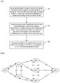
- Fig.1 is a flowchart of a route planning method for a navigation system according to an embodiment herein. As shown in Fig.1 , the method includes steps as follows.
- an actual geographic space is divided into grids; the grids may be cells of a cellular network; a handover record of inter-cell handovers of mobile stations is acquired; an inter-cell adjacency is modelled according to the handover record.
- the navigation system may divide the actual geographic space into grids as follows.
- the actual geographic space may be divided into multiple areas, each area being one grid.
- An inter-grid adjacency may then be modelled.
- the navigation system may divide the actual geographic space into grids, taking the cells of the cellular network as the grids, and model the inter-cell adjacency.
- a cell herein may be space covered by an antenna of a base station.
- mobility management signalling may serve for subscriber location management in the cellular network, and may provide rich information on trajectories of mobile stations.
- a handover record may be acquired once a cell-level displacement of a mobile station is observed at a base station side, such that the information on a trajectory of an object moving with the mobile station between the grids may be obtained.
- a signalling collecting platform of a mobile operator may collect the handover record from a base station controller via an Abis/lub interface.
- a handover record may be in a form as: ⁇ mobile station number, cell identifier, timestamp of entering cell>. All handover records collected within a period of time may be stored as a file in a storage space. A duration of the period of time may be set, according to processing capacity of the signalling collecting platform, to be say 15 minutes in general.
- the storage space may be a storage space in a dedicated File Transfer Protocol (FTP) server.
- FTP File Transfer Protocol
- a mobile operator may also acquire a handover record of an inter-cell handover of a mobile station, in particular an on-cab mobile station, by using an internet browsing record of the mobile station.
- the signalling collecting platform of the mobile operator may extract the handover record in form of ⁇ mobile station identifier, cell identifier, timestamp of entering cell> from a signalling record of a Package Switch (PS) domain, such as from a Call Detail Record CDR generated by Deep Package Inspection (DPI), and store all handover records collected within a period of time as a file in a storage space.
- a duration of the period of time may be set, according to processing capacity of the signalling collecting platform, to be say 15 minutes in general.
- the storage space may be a storage space in a dedicated FTP server.
- the signalling collecting platform of the mobile operator may provide a database for the navigation system to model the inter-cell adjacency according to the handover record.
- the navigation system may model the inter-grid/inter-cell adjacency as follows.
- step A the handover record of inter-cell handovers of mobile stations may be acquired regularly.
- the navigation system may read a file recording inter-cell handovers of mobile stations stored in the dedicated FTP server by the signalling collecting platform of the mobile operator, and acquire the handover records from the read file.
- the navigation system may filter the handover records according to a pre-set filtering solution.
- the navigation system may filter the records according to numbers of mobile stations.
- a record related to a number of a mobile station with no mobility may be deleted.
- some mobile stations do not have mobility.
- an camera provided at an intersection with a Subscriber Identity Module (SIM) card has an invariant location.
- SIM Subscriber Identity Module
- a base station will receive information on its location regularly, and the signalling collecting platform of the mobile operator will collect and save records of the camera provided at the intersection. The number of such a mobile station may be obtained in advance, and then the records related to the number are deleted.
- SIM Subscriber Identity Module
- only records related to specific mobile station numbers may be retained.
- only records related to on-cab mobile stations may be retained. It is known that an on-cab mobile station has higher mobility and covers a wider area than a mobile station of a common subscriber. Numbers of on-cab mobile stations may be acquired in advance, and only records related to on-cab mobile stations may be retained.
- the navigation system may filter the records according to cell identifiers.
- handover records In some cases, only a few handover records have been acquired, barely enough to reflect the inter-cell adjacency. In this case, it is necessary to refer to handover records acquired previously, such as those acquired a day before a present day. However, if a base station is newly built by the mobile operator on the present day, records related to an identifier of a cell of the newly-built base station are incompatible with the records the day before, and therefore have to be deleted. In this case, the navigation system has loaded original cell identifiers in a memory according to historical records. When a cell identifier in a handover record is not one of the cell identifiers loaded in the memory, the navigation system will delete the handover record.
- the navigation system may skip a record generated due to cell oscillation.
- a mobile station may perform an inter-cell handover while staying its original location. This is called cell oscillation. Since the mobile station actually does not move, such a handover record generated by cell oscillation fails to reflect the actual inter-cell adjacency, and thus shall not be considered.
- the navigation system may search for a most recent record O with a mobile station number M identical to that of the R, and determine whether a time interval T between the two records O and R is greater than 30 mins. When the time interval T is less than 30 mins, the navigation system may determine whether a cell identifier in the record R is that of one of two cells on which the mobile station number M recently camped, that are stored in the navigation system. When the cell identifier in the record R is that of either cell on which the mobile station number M recently camped, the record R may be deemed as a record generated by cell oscillation, and therefore may not be considered by the navigation system.
- At least one of the filtering solutions may be used.
- step B an inter-cell adjacency is modelled according to the handover record.
- the navigation system may extract trajectories of mobile stations within a period of time according to the handover record acquired regularly.
- the inter-cell adjacency within the period of time may be modelled according to the trajectories.
- the navigation system may extract the trajectories of mobile stations from the handover record with improved efficiency.
- the navigation system may extract the trajectories of mobile stations according to the handover record as follows.
- a cell migration pair may be used in the navigation system to represent a trajectory of a mobile station.
- a cell migration pair may be noted as ⁇ original cell identifier, destination cell identifier, residing duration>.
- the navigation system may store identifiers of two cells on which a mobile station recently camped, and respective timestamps when the mobile station entered the two cells. For example, the navigation system may store two cell identifiers X1 and X2 on which a mobile station M recently camped, a timestamp tt1 corresponding to X1, and a timestamp tt2 corresponding to X2.
- the tt2 may be greater than the tt1. That is, a most recent handover record of the mobile station M may be ⁇ M, X2, tt2>.
- the navigation system may clear the two stored cell identifiers on which the M recently camped by deleting records corresponding to the cell identifiers X1 and X2, and store the cell identifier n1 and the timestamp t1 in the record R.
- the navigation system may set a cell migration pair ⁇ X2, n1, t1-tt2> as a trajectory of the mobile station M, and updates the cell identifiers of two cells on which the mobile station M recently camped with X2 and n1.
- the timestamp tt2 may correspond to the cell identifier X2.
- the timestamp t1 may correspond to the cell identifier n1.
- All trajectories of the mobile station M may be obtained by processing all records related to the mobile station M as mentioned above, thereby obtaining the trajectories of all mobile stations.
- a set of all trajectories (namely cell migration pairs) within a period of time may be referred to as a snapshot.
- the period of time may be a snapshot time corresponding to the snapshot.
- a snapshot with a snapshot time of 15 mins may describe a set of all mobile-station trajectories acquired within 15 mins.
- the navigation system may maintain multiple historical snapshots and a present snapshot. To improve real-time sensing performance of the navigation system and collect an amount of data sufficient to meet a accuracy requirement of the model, a snapshot time of 15 mins to 1 hour may be appropriate.
- a snapshot may be stored as a file and/or in a database in memory. Historical snapshots may be stored persistently in a file system.
- a present snapshot and a historical snapshot of the same day may be stored in the database in memory.
- the database in memory may include a snapshot index table, including a time attribute, a holiday attribute, and a weather attribute of each snapshot.
- the time attribute may include a year, a quarter, a month, a week, a day, and a time period.
- the holiday attribute may indicate whether a day is a weekday, a weekend, a holiday, etc.
- the weather attribute may include a non-severe weather, a heavy rain, a heavy snow, a freeze, etc.
- the navigation system may model the inter-cell adjacency within the period of time according to the snapshot as follows.
- a weighted directed may be established according to the snapshot, with all the cells as vertices, inter-cell adjacencies as edges, and with an inter-cell adjacency index as a weight of an edge.
- the inter-cell adjacency index may be a probability of transfer between two cells, or a duration needed for transfer between two cells.
- a probability of transfer from the cell 1 to the cell 2 may be: a number of records of transfer from a source cell 1 to a destination cell 2 / a number of all records of transfer from the source cell 1.
- the probability of transfer from the cell 1 to the cell 2 may be set as a weight of an edge pointing from the cell 1 to the cell 2.
- Fig.2 is a diagram of a directed graph showing a probability of transfer between two cells according to an embodiment.
- a duration of transfer from the cell 1 to the cell 2 may be an average residing duration over all records ⁇ cell 1, cell 2, residing duration>.
- the duration of transfer from the cell 1 to the cell 2 may be set as a weight of an edge pointing from the cell 1 to the cell 2, and
- Fig.3 is a diagram of a directed graph showing a duration needed for transfer between two cells according to an embodiment.
- the solution II may be improved by using a higher-order contextual model such as a second-order model.
- a higher-order contextual model such as a second-order model.
- Implementation using a still higher-order model is possible, so on and so forth.
- a historical snapshot may be used together with the present snapshot for constructing the directed graph. However in this case, it has to be ensured that a context state of the historical snapshot matches a present state. Thus, a recent historical snapshot with index characteristics similar to present index characteristics has to be selected.
- step 102 a departure point and a destination point in the actual geographic space are mapped respectively to a departure grid and a destination grid; and a grid-level path from the departure grid to the destination grid is determined according to the modelled inter-grid adjacency.
- the navigation system may receive the departure point and the destination point input by a user, map the departure point to the departure grid and the destination point to the destination grid according to a location mapping relation, and determine a grid-level path from the departure grid to the destination grid according to the inter-grid adjacency modelled in step 101.
- a base station and/or cell closest to the departure/destination point may be selected as a departure base station/destination cell according to longitudes and latitudes of the departure point, the destination point, and the cells.
- the directed graph showing a probability of transfer between two cells may be established according to the solution I.
- An optimal path from a departure cell to a destination cell may be a most probable path among all paths starting from a node corresponding to the departure cell and ending at a node corresponding to the destination cell.
- the weight of an edge in the directed graph showing a probability of transfer may be modified as -log(original edge weight). Accordingly, optimal path computation may be converted into solving a standard problem of search for a shortest path.
- the directed graph showing a duration needed for transfer between two cells may be established according to the solution II.
- solving an optimal path from a departure cell to a destination cell may be converted into searching the directed graph for a shortest path.
- step 103 the grid-level path is converted into an actual route from the departure point to the destination point in the actual geographic space.
- the navigation system may map the grid-level path computed in step 102 onto a GIS map and /or a satellite map to obtain the actual route from the departure point to the destination point.
- a cell-level path may be mapped onto a GIS map and be converted into an actual route as follows.
- the cell-level path may be converted into a polyline in two-dimensional space according to longitudes and latitudes of cells and/or base stations in the cell-level path.
- the polyline may be smoothed using least squares to obtain a smoothed curve.
- the curve may be buffered or padded with a distance of 500 metres to obtain an area. All roads in the GIS map passing through or contained in the area may be selected.
- a route from the departure point to the destination point may be computed using a dynamic planning algorithm and a subset of the map.
- the cells of the cellular network may be set as the grids.
- a cell-level path may be mapped onto a satellite map and be converted into an actual route as follows.
- the satellite map displaying the cell-level path may be delivered to a user.
- the user may select a route as instructed by the path according to an actual road condition reflected by the satellite map.
- a user may be provided with a road option unavailable in a GIS map, avoiding a problem of GIS map information lagging behind the actual road condition, as generally a newly-built road may not be updated to and displayed in the GIS map in at least three months.
- route planning may be performed in two stages. First, an actual geographic space is divided into grids using cells of a cellular network. Then, trajectories of mobile stations may be extracted using records of inter-cell handovers of the mobile stations acquired from a mobile operator, such that information on trajectories of multiple real mobile stations may be sensed in real time.
- Path planning may be performed in a cell space of the cellular network, and then route matching may be performed based on a GIS map or a satellite map, which may lower dependence on the accuracy and timeliness of the GIS map, increasing real-time performance, accuracy, and effectiveness of a route planning result, as well as facilitating detecting an error in the GIS map, thereby providing an optimal path tolerant to a map fault.
- the method herein is based on a mobile communication network, thereby requiring but a low cost of deployment, leading to wide applicability.
- a non-transitory computer-readable storage medium stores therein computer executable instructions for executing aforementioned route planning method for a navigation system herein.
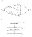
- Fig.4 is a diagram of a structure of a route planning device for a navigation system according to an embodiment herein.
- the route planning device includes a grid modelling module 41, a grid path finding module 42, and a path converting module 43.
- the grid modelling module 41 is configured for: dividing an actual geographic space into grids, the grids being cells of a cellular network; acquiring a handover record of inter-cell handovers of mobile stations; and modelling an inter-cell adjacency according to the handover record.
- the grid path finding module 42 is configured for: mapping a departure point and a destination point in the actual geographic space respectively to a departure grid and a destination grid; and determining, according to the modelled inter-cell adjacency, a grid-level path from the departure grid to the destination grid.
- the path converting module 43 is configured for: converting the grid-level path into an actual route from the departure point to the destination point in the actual geographic space.
- the grids may be the cells of the cellular network. Accordingly, the grid modelling module 41 in the route planning device may be further configured for: filtering the handover record according to a pre-set filtering solution.
- the grid modelling module 41 may include:
- the modelling sub-module may be further configured for:
- the inter-cell adjacency index may be a probability of transfer between two cells, or a duration needed for transfer between two cells.
- the path converting module 43 may include:
- all the modules and the units may be implemented by a Central Processing Unit (CPU), a Micro Processing Unit (MPU), a Digital Signal Processor (DSP), or a Field-Programmable Gate Array (FPGA) located in the navigation system.
- CPU Central Processing Unit
- MPU Micro Processing Unit
- DSP Digital Signal Processor
- FPGA Field-Programmable Gate Array
- the device shown in Fig.4 solves a problem in a way similar to the method. Refer to implementation of the method as described for that of the device herein, which will not be repeated.
- an embodiment herein may be provided as a method, system, or computer program product. Therefore, an embodiment herein may take on a form of hardware, software, or a combination thereof. In addition, an embodiment herein may take on a form of a computer program product implemented on one or more computer available storage media (including but not limited to, magnetic disk memory, optic memory, and the like) containing computer available program codes.
- a computer available storage media including but not limited to, magnetic disk memory, optic memory, and the like
- each flow in the flowcharts and/or each block in the block diagrams as well as combination of flows in the flowcharts and/or blocks in the block diagrams may be implemented by instructions of a computer program.
- Such instructions may be offered in a processor of a general-purpose computer, a dedicated computer, an embedded processor or other programmable data processing devices to generate a machine, such that a device with a function specified in one or more flows of the flowcharts and/or one or more blocks in the block diagrams is produced by instructions executed by a processor of a computer or other programmable data processing devices.
- These computer-program instructions may also be stored in a non-transitory computer-readable memory capable of guiding a computer or another programmable data processing device to work in a given way, such that the instructions stored in the computer-readable memory generate a manufactured good including an instruction device for implementing a function specified in one or more flows of the flowcharts and/or one or more blocks in the block diagrams.
- These computer-program instructions may also be loaded in a computer or other programmable data processing devices, which thus executes a series of operations thereon to generate computer-implemented processing, such that the instructions executed on the computer or other programmable data processing devices provide the steps for implementing the function specified in one or more flows of the flowcharts or one or more blocks in the block diagrams.
- route planning may be performed in two stages. First, an actual geographic space is divided into grids using cells of a cellular network. Then, trajectories of mobile stations may be extracted using records of inter-cell handovers of the mobile stations acquired from a mobile operator, such that information on trajectories of multiple real mobile stations may be sensed in real time.
- Path planning may be performed in a cell space of the cellular network, and then route matching may be performed based on a GIS map or a satellite map, which may lower dependence on the accuracy and timeliness of the GIS map, increasing real-time performance, accuracy, and effectiveness of a route planning result , as well as facilitating detecting an error in the GIS map, thereby providing an optimal path tolerant to a map fault.
- the method herein is based on a mobile communication network, thereby requiring but a low cost of deployment, leading to wide applicability.
Landscapes
- Engineering & Computer Science (AREA)
- Computer Networks & Wireless Communication (AREA)
- Signal Processing (AREA)
- Radar, Positioning & Navigation (AREA)
- Remote Sensing (AREA)
- Physics & Mathematics (AREA)
- General Physics & Mathematics (AREA)
- Automation & Control Theory (AREA)
- Mathematical Physics (AREA)
- Data Mining & Analysis (AREA)
- Databases & Information Systems (AREA)
- Navigation (AREA)
- Instructional Devices (AREA)
- Traffic Control Systems (AREA)
- Mobile Radio Communication Systems (AREA)
Applications Claiming Priority (2)
| Application Number | Priority Date | Filing Date | Title |
|---|---|---|---|
| CN201410419871.7A CN105466435B (zh) | 2014-08-22 | 2014-08-22 | 一种导航系统的路线规划方法和装置 |
| PCT/CN2015/071028 WO2015131681A1 (zh) | 2014-08-22 | 2015-01-19 | 一种导航系统的路线规划方法、装置和存储介质 |
Publications (2)
| Publication Number | Publication Date |
|---|---|
| EP3086302A1 true EP3086302A1 (de) | 2016-10-26 |
| EP3086302A4 EP3086302A4 (de) | 2017-08-23 |
Family
ID=54054533
Family Applications (1)
| Application Number | Title | Priority Date | Filing Date |
|---|---|---|---|
| EP15758250.3A Withdrawn EP3086302A4 (de) | 2014-08-22 | 2015-01-19 | Routenplanungsverfahren und vorrichtung für ein navigationssystem und speichermedium |
Country Status (6)
| Country | Link |
|---|---|
| US (1) | US10119829B2 (de) |
| EP (1) | EP3086302A4 (de) |
| JP (1) | JP2017524902A (de) |
| KR (1) | KR101909365B1 (de) |
| CN (1) | CN105466435B (de) |
| WO (1) | WO2015131681A1 (de) |
Families Citing this family (17)
| Publication number | Priority date | Publication date | Assignee | Title |
|---|---|---|---|---|
| US10169400B2 (en) * | 2015-06-19 | 2019-01-01 | International Business Machines Corporation | Geographic space management |
| CN107133339A (zh) * | 2017-05-17 | 2017-09-05 | 北京趣拿软件科技有限公司 | 线路查询方法和装置以及存储介质、处理器 |
| CN110650507B (zh) * | 2018-06-27 | 2022-03-08 | 中兴通讯股份有限公司 | 一种小区切换判决方法、装置、设备和边缘计算节点 |
| CN109299822A (zh) * | 2018-09-21 | 2019-02-01 | 中国联合网络通信集团有限公司 | 车辆调度方法、装置、系统及存储介质 |
| CN109800957B (zh) * | 2018-12-24 | 2023-02-03 | 武汉思路富邦工程咨询有限公司 | Bim工程项目规划路线快速生成的方法 |
| CN110109134B (zh) * | 2019-05-05 | 2022-11-25 | 桂林电子科技大学 | 一种基于2d激光雷达测距的折线提取极大似然估计的方法 |
| CN110706356B (zh) * | 2019-09-19 | 2023-06-16 | 阿波罗智联(北京)科技有限公司 | 路径绘制方法、装置、电子设备和存储介质 |
| CN112954749B (zh) * | 2019-12-11 | 2022-05-10 | 华为技术有限公司 | 一种网络切换方法及电子设备 |
| US11882507B2 (en) | 2020-01-08 | 2024-01-23 | Veniam, Inc. | Methods and systems for in-vehicle data-driven connectivity optimization in a network of moving things |
| CN111641984B (zh) * | 2020-05-28 | 2022-11-04 | 哲库科技(北京)有限公司 | 一种小区选择方法及终端、存储介质 |
| CN111884939B (zh) * | 2020-08-31 | 2022-04-08 | 广州文远知行科技有限公司 | 数据传输方法、装置、可移动载体和存储介质 |
| KR102671170B1 (ko) * | 2020-09-18 | 2024-06-03 | 한국전력공사 | 분산전원 연계 경로 생성 장치 및 그 방법 |
| CN112101676B (zh) * | 2020-09-23 | 2022-02-15 | 腾讯科技(深圳)有限公司 | 一种乘车路径规划方法、装置、计算机设备及存储介质 |
| CN113190769B (zh) * | 2021-05-08 | 2023-09-19 | 北京百度网讯科技有限公司 | 通勤特征数据确定方法、装置、电子设备和存储介质 |
| JP7609027B2 (ja) * | 2021-09-30 | 2025-01-07 | トヨタ自動車株式会社 | 情報処理装置、情報処理システム、およびプログラム |
| FR3140507A1 (fr) * | 2022-09-30 | 2024-04-05 | Orange | Détermination d’un itinéraire en fonction de la qualité de service d’un réseau de communication |
| CN117915417B (zh) * | 2024-03-19 | 2024-06-18 | 深圳心派科技有限公司 | 一种基站切换规划方法、装置及系统 |
Family Cites Families (28)
| Publication number | Priority date | Publication date | Assignee | Title |
|---|---|---|---|---|
| US5295180A (en) * | 1992-04-08 | 1994-03-15 | U S West Newvector Group, Inc. | Cellular telephone zone system |
| US20030008619A1 (en) * | 2001-07-03 | 2003-01-09 | Werner Raymond J. | Location-based information service for identifying areas with degraded radio signal strength |
| US7373152B2 (en) * | 2002-11-13 | 2008-05-13 | General Motors Corporation | Radio signal strength mapping through a telematics system |
| US6853910B1 (en) * | 2003-08-11 | 2005-02-08 | General Motors Corporation | Vehicle tracking telematics system |
| US20050156715A1 (en) * | 2004-01-16 | 2005-07-21 | Jie Zou | Method and system for interfacing with mobile telemetry devices |
| US8260322B2 (en) | 2005-02-15 | 2012-09-04 | Trimble Navigation Limited | Method for locating coverage gaps in wireless communication services |
| US20060242108A1 (en) | 2005-04-25 | 2006-10-26 | The Boeing Company | Advanced ground transportation management |
| US7609678B2 (en) * | 2006-03-13 | 2009-10-27 | Alcatel-Lucent Usa Inc. | Providing information on wireless service coverage along routes being considered for a journey |
| EP2102592A1 (de) * | 2007-01-10 | 2009-09-23 | TomTom International B.V. | Navigationsvorrichtung und verfahren zur festlegung von netzwerkabdeckungen |
| CN101272590A (zh) * | 2007-03-21 | 2008-09-24 | 展讯通信(上海)有限公司 | 到达时间-接收强度联合无线定位方法及装置 |
| US20080242315A1 (en) * | 2007-03-27 | 2008-10-02 | Gm Global Technology Operations, Inc. | Traffic data collection utilizing a cellular communication network and probe units |
| WO2009021068A1 (en) * | 2007-08-06 | 2009-02-12 | Trx Systems, Inc. | Locating, tracking, and/or monitoring personnel and/or assets both indoors and outdoors |
| CN101400104A (zh) * | 2008-10-24 | 2009-04-01 | 中国移动通信集团山东有限公司 | 实现移动定位服务的方法及系统 |
| US8290516B2 (en) | 2009-10-01 | 2012-10-16 | Nokia Corporation | Method and apparatus for providing location based services using connectivity graphs based on cell broadcast information |
| US8260546B2 (en) * | 2009-12-14 | 2012-09-04 | At&T Mobility Ii Llc | Systems and methods for providing geographical information to a mobile communications device |
| CN101794516B (zh) | 2009-12-25 | 2011-11-23 | 北京工业大学 | 基于手机信息的路段速度计算方法 |
| US9157745B2 (en) * | 2010-01-14 | 2015-10-13 | Qualcomm Incorporated | Scalable routing for mobile station navigation with location context identifier |
| US8504034B2 (en) | 2010-11-09 | 2013-08-06 | Ntt Docomo, Inc. | System and method for population tracking, counting, and movement estimation using mobile operational data and/or geographic information in mobile network |
| CN102521973B (zh) * | 2011-12-28 | 2016-03-30 | 昆明理工大学 | 一种手机切换定位的道路匹配方法 |
| US9453734B2 (en) * | 2012-06-05 | 2016-09-27 | Apple Inc. | Smart loading of map tiles |
| US8972175B2 (en) * | 2013-03-14 | 2015-03-03 | Qualcomm Incorporated | Navigation using crowdsourcing data |
| US9303997B2 (en) * | 2013-03-15 | 2016-04-05 | Apple Inc. | Prediction engine |
| US10563988B2 (en) * | 2013-12-06 | 2020-02-18 | Sap Se | Sensor-less indoor navigation assistance |
| US9002634B1 (en) * | 2013-12-12 | 2015-04-07 | Verizon Patent And Licensing Inc. | Navigation service in support of mobile communication sessions |
| US9762339B2 (en) * | 2014-02-11 | 2017-09-12 | Panasonic Automotive Systems Company of North America, Division of Panasonic Corporation of North America | Terrestrial radio switch manager for smart cellular streaming |
| US9680957B2 (en) * | 2014-08-11 | 2017-06-13 | Harman International Industries, Incorporated | Adaptive bandwidth consumption optimization for wireless data connections |
| US9565625B1 (en) * | 2015-09-09 | 2017-02-07 | Ford Global Technologies, Llc | Multiprotocol vehicle communications |
| US9432929B1 (en) * | 2015-12-08 | 2016-08-30 | Uber Technologies, Inc. | Communication configuration system for a fleet of automated vehicles |
-
2014
- 2014-08-22 CN CN201410419871.7A patent/CN105466435B/zh active Active
-
2015
- 2015-01-19 US US15/112,512 patent/US10119829B2/en active Active
- 2015-01-19 JP JP2016569748A patent/JP2017524902A/ja active Pending
- 2015-01-19 WO PCT/CN2015/071028 patent/WO2015131681A1/zh not_active Ceased
- 2015-01-19 KR KR1020167030846A patent/KR101909365B1/ko active Active
- 2015-01-19 EP EP15758250.3A patent/EP3086302A4/de not_active Withdrawn
Also Published As
| Publication number | Publication date |
|---|---|
| CN105466435B (zh) | 2020-07-10 |
| CN105466435A (zh) | 2016-04-06 |
| WO2015131681A1 (zh) | 2015-09-11 |
| JP2017524902A (ja) | 2017-08-31 |
| KR20160143741A (ko) | 2016-12-14 |
| US10119829B2 (en) | 2018-11-06 |
| EP3086302A4 (de) | 2017-08-23 |
| KR101909365B1 (ko) | 2018-10-17 |
| US20160334237A1 (en) | 2016-11-17 |
Similar Documents
| Publication | Publication Date | Title |
|---|---|---|
| US10119829B2 (en) | Route planning method and device for navigation system and storage medium | |
| CN109996186B (zh) | 一种网络覆盖问题识别方法及装置、可读取存储介质 | |
| US10955586B2 (en) | Weather forecasting system and methods | |
| US8577389B2 (en) | Filtering and clustering crowd-sourced data for determining beacon positions | |
| CN102147260B (zh) | 电子地图匹配方法和装置 | |
| EP3137918B1 (de) | Positionierungsanordnung, verfahren, mobile vorrichtung und computerprogramm | |
| US8359156B2 (en) | Map generation system and map generation method by using GPS tracks | |
| USRE47107E1 (en) | Method and system for navigation using bounded geographic regions | |
| CN111787488B (zh) | 一种用户定位方法及系统 | |
| Shang et al. | Finding traffic-aware fastest paths in spatial networks | |
| CN107871400A (zh) | 路网信息更新方法及装置 | |
| CN104599499B (zh) | 一种分布式统计交通位置的方法及装置 | |
| KR20240046793A (ko) | 위치결정 방법 및 장치, 그리고 디바이스 및 저장 매체 | |
| US9651389B2 (en) | Generation of location area boundaries | |
| CN113518328A (zh) | 一种网络接入设备的识别方法、定位方法、装置和设备 | |
| CN115687546A (zh) | 一种地图数据处理方法及装置 | |
| CN116698075B (zh) | 路网数据处理方法、装置、电子设备及存储介质 | |
| TWI418836B (zh) | Wireless network signal collection and verification system | |
| CN113593244A (zh) | 一种流量确定方法、装置、存储介质及电子装置 | |
| CN113254565B (zh) | 区域识别方法、装置、计算机设备及计算机可读存储介质 | |
| CN114067594A (zh) | 行驶路径的规划方法、装置、计算机设备和存储介质 | |
| CN111552759B (zh) | 一种行动轨迹相关数据的获取方法、装置、设备及介质 | |
| KR20050061270A (ko) | 인빌딩 품질관리 시스템 | |
| CN116819577A (zh) | 道路识别方法、装置、电子设备及存储介质 | |
| EA035933B1 (ru) | Способ и система построения карты маршрута транспортного средства на основе данных телематики |
Legal Events
| Date | Code | Title | Description |
|---|---|---|---|
| PUAI | Public reference made under article 153(3) epc to a published international application that has entered the european phase |
Free format text: ORIGINAL CODE: 0009012 |
|
| 17P | Request for examination filed |
Effective date: 20160719 |
|
| AK | Designated contracting states |
Kind code of ref document: A1 Designated state(s): AL AT BE BG CH CY CZ DE DK EE ES FI FR GB GR HR HU IE IS IT LI LT LU LV MC MK MT NL NO PL PT RO RS SE SI SK SM TR |
|
| AX | Request for extension of the european patent |
Extension state: BA ME |
|
| A4 | Supplementary search report drawn up and despatched |
Effective date: 20170726 |
|
| RIC1 | Information provided on ipc code assigned before grant |
Ipc: H04W 36/00 20090101ALI20170720BHEP Ipc: H04W 4/02 20090101ALI20170720BHEP Ipc: G01C 21/34 20060101AFI20170720BHEP Ipc: H04W 4/04 20090101ALI20170720BHEP Ipc: G08G 1/0968 20060101ALI20170720BHEP Ipc: H04W 64/00 20090101ALI20170720BHEP |
|
| DAX | Request for extension of the european patent (deleted) | ||
| STAA | Information on the status of an ep patent application or granted ep patent |
Free format text: STATUS: THE APPLICATION HAS BEEN WITHDRAWN |
|
| RIC1 | Information provided on ipc code assigned before grant |
Ipc: H04W 4/029 20180101ALI20201211BHEP Ipc: H04W 4/40 20180101ALI20201211BHEP Ipc: H04W 8/18 20090101ALI20201211BHEP Ipc: G01C 21/34 20060101AFI20201211BHEP Ipc: H04W 4/024 20180101ALI20201211BHEP Ipc: G08G 1/0968 20060101ALI20201211BHEP Ipc: H04W 4/02 20180101ALI20201211BHEP |
|
| 18W | Application withdrawn |
Effective date: 20201228 |