EP3144828A1 - Kartenabfrageverfahren, vorrichtung, ausrüstung und computerspeichermedium - Google Patents
Kartenabfrageverfahren, vorrichtung, ausrüstung und computerspeichermedium Download PDFInfo
- Publication number
- EP3144828A1 EP3144828A1 EP15792903.5A EP15792903A EP3144828A1 EP 3144828 A1 EP3144828 A1 EP 3144828A1 EP 15792903 A EP15792903 A EP 15792903A EP 3144828 A1 EP3144828 A1 EP 3144828A1
- Authority
- EP
- European Patent Office
- Prior art keywords
- route
- inquired
- user
- extracted
- interest
- Prior art date
- Legal status (The legal status is an assumption and is not a legal conclusion. Google has not performed a legal analysis and makes no representation as to the accuracy of the status listed.)
- Ceased
Links
Images
Classifications
-
- G—PHYSICS
- G06—COMPUTING OR CALCULATING; COUNTING
- G06F—ELECTRIC DIGITAL DATA PROCESSING
- G06F16/00—Information retrieval; Database structures therefor; File system structures therefor
- G06F16/40—Information retrieval; Database structures therefor; File system structures therefor of multimedia data, e.g. slideshows comprising image and additional audio data
- G06F16/44—Browsing; Visualisation therefor
- G06F16/444—Spatial browsing, e.g. 2D maps, 3D or virtual spaces
-
- G—PHYSICS
- G01—MEASURING; TESTING
- G01C—MEASURING DISTANCES, LEVELS OR BEARINGS; SURVEYING; NAVIGATION; GYROSCOPIC INSTRUMENTS; PHOTOGRAMMETRY OR VIDEOGRAMMETRY
- G01C21/00—Navigation; Navigational instruments not provided for in groups G01C1/00 - G01C19/00
- G01C21/10—Navigation; Navigational instruments not provided for in groups G01C1/00 - G01C19/00 by using measurements of speed or acceleration
-
- G—PHYSICS
- G01—MEASURING; TESTING
- G01C—MEASURING DISTANCES, LEVELS OR BEARINGS; SURVEYING; NAVIGATION; GYROSCOPIC INSTRUMENTS; PHOTOGRAMMETRY OR VIDEOGRAMMETRY
- G01C21/00—Navigation; Navigational instruments not provided for in groups G01C1/00 - G01C19/00
- G01C21/20—Instruments for performing navigational calculations
-
- G—PHYSICS
- G01—MEASURING; TESTING
- G01C—MEASURING DISTANCES, LEVELS OR BEARINGS; SURVEYING; NAVIGATION; GYROSCOPIC INSTRUMENTS; PHOTOGRAMMETRY OR VIDEOGRAMMETRY
- G01C21/00—Navigation; Navigational instruments not provided for in groups G01C1/00 - G01C19/00
- G01C21/26—Navigation; Navigational instruments not provided for in groups G01C1/00 - G01C19/00 specially adapted for navigation in a road network
- G01C21/34—Route searching; Route guidance
- G01C21/36—Input/output arrangements for on-board computers
- G01C21/3679—Retrieval, searching and output of POI information, e.g. hotels, restaurants, shops, filling stations, parking facilities
-
- G—PHYSICS
- G06—COMPUTING OR CALCULATING; COUNTING
- G06F—ELECTRIC DIGITAL DATA PROCESSING
- G06F16/00—Information retrieval; Database structures therefor; File system structures therefor
-
- G—PHYSICS
- G06—COMPUTING OR CALCULATING; COUNTING
- G06F—ELECTRIC DIGITAL DATA PROCESSING
- G06F16/00—Information retrieval; Database structures therefor; File system structures therefor
- G06F16/90—Details of database functions independent of the retrieved data types
- G06F16/95—Retrieval from the web
- G06F16/953—Querying, e.g. by the use of web search engines
- G06F16/9537—Spatial or temporal dependent retrieval, e.g. spatiotemporal queries
Definitions
- the present disclosure relates to a method and an apparatus for inquiring a map, a device and a computer storage medium, more particularly to a technique of map inquiring according to a demand of a user contained in a query statement.
- map service systems may not only provide users with the search for a variety of points of interest via the Internet, but may also provide routes, road condition inquiries and other navigation functions.
- these map service systems require the user to input explicit location information in order to provide the feedback results related thereto. If the location information inputted by the user is inexplicit or the information inputted is overgeneralized, the feedback result is frequently empty, and sometimes even if the user changes the search content inputted for several times, one cannot get the results in accordance with his/her demand.
- Embodiments of the present disclosure aim to provide a method and an apparatus for inquiring a map, a device and a computer storage medium, which may not only perform a map inquiry according to a user's demand contained in a query statement, but also enable a result of the map inquiry to be closer to the user's demand.
- a method for inquiring a map includes: receiving a query statement inputted by a user; performing a word segmentation on the query statement received to obtain a result of the word segmentation; extracting specific information related to a demand of the user from the result of the word segmentation; inquiring a route and/or a point of interest related to the specific information extracted in a map.
- inquiring a route related to the specific information extracted in a map includes: determining a site as a terminal point of a route planning, if there is information about the site in the specific information extracted; positioning a geographical position where the user is located to obtain a positioning result, and determining the positioning result as an origin of the route planning; inquiring the route related to the specific information extracted in the map according to the origin and the terminal point determined.
- the method further includes: acquiring road condition information of the route inquired at a time, if there is also information about the time in the specific information extracted.
- the method further includes: calculating a travel time of the user in accordance with the route inquired, according to the route inquired and the road condition information acquired.
- calculating a travel time of the user in accordance with the route inquired specifically includes:
- inquiring a point of interest related to the specific information extracted in a map includes: inquiring the point of interest related to a site, if there is information about the site in the specific information extracted.
- the method further includes: selecting a point of interest related to an event from the points of interest inquired, if there is also information about the event in the specific information extracted.
- selecting a point of interest related to an event from the points of interest inquired includes: determining an action related to the event; extracting a word with a better comment related to the action determined from comment information of the point of interest inquired; calculating a contact strength between the word extracted and the event; using the word extracted as a key word to select the point of interest related to the event from the points of interest inquired, if the contact strength calculated is in accordance with a predetermined condition.
- calculating a contact strength between the word extracted and the event specifically includes:
- an apparatus for inquiring a map includes: a receiving unit, configured to receive a query statement inputted by a user; a word-segmenting unit, configured to perform a word segmentation on the query statement received to obtain a result of the word segmentation; an extracting unit, configured to extract specific information related to a demand of the user from the result of the word segmentation; an inquiring unit, configured to inquiry a route and/or a point of interest related to the specific information extracted in a map.
- the inquiring unit includes: a terminal point determining sub-unit, configured to determine a site as a terminal point of a route planning, if there is information about the site in the specific information extracted; an origin determining sub-unit, configured to position a geographical position where the user is located to obtain a positioning result, and to determine the positioning result as an origin of the route planning; a route inquiring sub-unit, configured to inquiry the route related to the specific information extracted in the map according to the origin and the terminal point determined.
- a terminal point determining sub-unit configured to determine a site as a terminal point of a route planning, if there is information about the site in the specific information extracted
- an origin determining sub-unit configured to position a geographical position where the user is located to obtain a positioning result, and to determine the positioning result as an origin of the route planning
- a route inquiring sub-unit configured to inquiry the route related to the specific information extracted in the map according to the origin and the terminal point determined.
- the apparatus further includes: a road condition acquiring unit, configured to acquire road condition information of the route inquired at a time, if there is also information about the time in the specific information extracted.
- a road condition acquiring unit configured to acquire road condition information of the route inquired at a time, if there is also information about the time in the specific information extracted.
- the apparatus further includes: a travel time calculating unit, configured to calculate a travel time of the user in accordance with the route inquired, according to the route inquired and the road condition information acquired.
- a travel time calculating unit configured to calculate a travel time of the user in accordance with the route inquired, according to the route inquired and the road condition information acquired.
- the inquiring unit is configured to inquire the point of interest related to a site, if there is information about the site in the specific information extracted.
- the apparatus further includes: an event selecting unit, configured to select a point of interest related to an event from the points of interest inquired, if there is also information about the event in the specific information extracted.
- an event selecting unit configured to select a point of interest related to an event from the points of interest inquired, if there is also information about the event in the specific information extracted.
- the event selecting unit includes: a related action determining sub-unit, configured to determine an action related to the event; a comment information extracting sub-unit, configured to extract a word with a better comment related to the action determined from comment information of the point of interest inquired; a contact strength calculating sub-unit, configured to calculate a contact strength between the word extracted and the event; a point of interest selecting sub-unit, configured to use the word extracted as a key word to select the point of interest related to the event from the points of interest inquired, if the contact strength calculated is in accordance with a predetermined condition.
- the present disclosure may not only perform the map inquiry according to the user's demand contained in the query statement, but also enable the result of the map inquiry to be closer to the user's demand. Meanwhile, this also enables the map inquiry to be more intelligent, thus improving a user's experience.
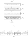
- Fig. 1 is a flow chart of a method for inquiring a map according to a preferred embodiment of the present disclosure.
- An apparatus for inquiring a map shown in Fig. 2 may be used to realize the method illustrated in Fig. 1 .
- step 110 the apparatus receives a query statement inputted by a user.
- step 120 the apparatus performs a word segmentation on the query statement received to obtain a result of the word segmentation.
- step 130 the apparatus extracts specific information related to a demand of the user from the result of the word segmentation.
- step 140 the apparatus inquires a route and/or a point of interest related to the specific information extracted in a map.
- the specific information related to the demand of the user may be any one of following information: time, location, figure, event, or may be other information, which is not constructed to be limited in the present disclosure, as long as the specific information extracted can fully reflect the demand of the user.
- inquiring the route related to the specific information extracted in the map by the apparatus includes following specific steps: determining a site as a terminal point of a route planning, if there is information about the site in the specific information extracted; positioning a geographical position where the user is located to obtain a positioning result, and determining the positioning result as an origin of the route planning; inquiring the route related to the specific information extracted in the map according to the origin and the terminal point determined.
- the method further includes: acquiring road condition information of the route inquired at a time by the apparatus, if there is also information about the time in the specific information extracted.
- the road condition information will return traffic congestion information of each road section in the route inquired, for instance, in following road condition information: c 1 , c 2 : 0.8 , c 2 , c 3 : 0.5 , c 3 , c 4 : ⁇ 0.9 , ...
- c1 represents an origin of a road section [c1, c2]
- c2 represents a terminal point of a road section [c1, c2] and so forth.
- the value is in a range from -1 to 1, where 1 represents clearness, and -1 represents a congestion.
- the method further includes: calculating a travel time of the user in accordance with the route inquired by the apparatus, according to the route inquired and the road condition information acquired.
- T v represents a travel time of the user in accordance with a self-driving route inquired
- S i represents a travel distance of an i th road section on the self-driving route inquired
- X i represents a road condition congestion value of the i th road section on the self-driving route inquired
- V v represents a predetermined speed of a self-driving vehicle (e.g. a predetermined speed of 60km/h);
- Rate v represents a congestion influence rate of the self-driving on the travel time.
- T p represents a travel time of the user in accordance with a public transport route inquired
- S i represents a travel distance of an i th road section on the public transport route inquired
- X i represents a road condition congestion value of the i th road section on the public transport route inquired
- V p represents a predetermined speed of public transport (e.g. a speed of a subway may be predetermined as 80km/h);
- Rate v represents a congestion influence rate of the public transport on the travel time.
- the apparatus may implement separately any one of the three exemplary embodiments for calculating the travel time, or may implement a combination of the three exemplary embodiments for calculating the travel time. For instance, the apparatus may also recommend a route with the shortest travel time to the user by comparison.
- inquiring a point of interest related to the specific information extracted in a map by the apparatus includes following specific step: inquiring the point of interest related to a site by the apparatus, if there is information about the site in the specific information extracted. For instance, if location information extracted is "Shangdi Hualian", the points of interest related to the location include "Hallasan Shangdi Hualian Branch”, “Xinladao Hualian Branch”, “Xiabuxiabu Hualian Branch", “Jiahe Studio”, etc.
- the method further includes: selecting a point of interest related to an event from the points of interest inquired, if there is also information about the event in the specific information extracted.
- selecting a point of interest related to an event from the points of interest inquired includes following specific steps: determining an action related to the event by the apparatus; extracting a word with a better comment related to the action determined from comment information of the point of interest inquired; calculating a contact strength between the word extracted and the event (i.e., an emotional tendency of the user); using the word extracted as a key word to select the point of interest related to the event from the points of interest inquired, if the contact strength calculated is in accordance with a predetermined condition. For instance, if the information about the event extracted is "date”, the action information related to the information about the event refers to "eat”, “drink coffee", “watch movie”, “buy flowers”, etc.
- the apparatus may implement separately any one of the three exemplary embodiments for calculating the contact strength, or may implement a combination of the three exemplary embodiments for calculating the contact strength, which are not construed to limit the present disclosure.
- the apparatus includes at least a receiving unit 201, a word-segmenting unit 202, an extracting unit 203 and an inquiring unit 204.
- the receiving unit 201 is configured to receive a query statement inputted by a user.
- the word-segmenting unit 202 is configured to perform a word segmentation on the query statement received to obtain a result of the word segmentation.
- the extracting unit 203 is configured to extract specific information related to a demand of the user from the result of the word segmentation.
- the inquiring unit 204 is configured to inquiry a route and/or a point of interest related to the specific information extracted in a map.
- the specific information related to the demand of the user may be any one of following information: time, location, figure, event, or may be other information, which is not constructed to be limited in the present disclosure, as long as the specific information extracted can fully reflect the demand of the user.
- the inquiring unit 204 includes: a terminal point determining sub-unit (not shown in the figure), configured to determine a site as a terminal point of a route planning, if there is information about the site in the specific information extracted; an origin determining sub-unit (not shown in the figure), configured to position a geographical position where the user is located to obtain a positioning result, and to determine the positioning result as an origin of the route planning; a route inquiring sub-unit (not shown in the figure), configured to inquiry the route related to the specific information extracted in the map according to the origin and the terminal point determined.
- the apparatus further includes: a road condition acquiring unit, configured to acquire road condition information of the route inquired at a time, if there is also information about the time in the specific information extracted.
- the apparatus further includes: a travel time calculating unit, configured to calculate a travel time of the user in accordance with the route inquired, according to the route inquired and the road condition information acquired.
- T v represents a travel time of the user in accordance with a self-driving route inquired
- S i represents a travel distance of an i th road section on the self-driving route inquired
- X i represents a road condition congestion value of the i th road section on the self-driving route inquired
- V v represents a predetermined speed of a self-driving vehicle
- Rate v represents a congestion influence rate of the self-driving on the travel time.
- T p represents a travel time of the user in accordance with a public transport route inquired
- S i represents a travel distance of an i th road section on the public transport route inquired
- X i represents a road condition congestion value of the i th road section on the public transport route inquired
- V p represents a predetermined speed of public transport
- Rate v represents a congestion influence rate of the public transport on the travel time.
- the apparatus may implement separately any one of the three exemplary embodiments for calculating the travel time, or may implement a combination of the three exemplary embodiments for calculating the travel time, which are not construed to limit the present disclosure.
- the inquiring unit is configured to inquire the point of interest related to a site, if there is information about the site in the specific information extracted.
- the apparatus further includes: an event selecting unit (not shown in the figure), configured to select a point of interest related to an event from the points of interest inquired, if there is also information about the event in the specific information extracted.
- an event selecting unit (not shown in the figure), configured to select a point of interest related to an event from the points of interest inquired, if there is also information about the event in the specific information extracted.
- the event selecting unit includes: a related action determining sub-unit, configured to determine an action related to the event; a comment information extracting sub-unit, configured to extract a word with a better comment related to the action determined from comment information of the point of interest inquired; a contact strength calculating sub-unit, configured to calculate a contact strength between the word extracted and the event; a point of interest selecting sub-unit, configured to use the word extracted as a key word to select the point of interest related to the event from the points of interest inquired, if the contact strength calculated is in accordance with a predetermined condition.
- the apparatus may implement separately any one of the three exemplary embodiments for calculating the contact strength, or may implement a combination of the three exemplary embodiments for calculating the contact strength, which are not construed to limit the present disclosure.
- the present disclosure may not only perform the map inquiry according to the user's demand contained in the query statement, but also enable the result of the map inquiry to be closer to the user's demand. Meanwhile, this also enables the map inquiry to be more intelligent, thus improving a user's experience.
- each step described in the present disclosure may be divided into more steps, or two or more steps or partial operations of steps may be combined into a new step, so as to achieve the purpose of the present disclosure.
- the method above according to the present disclosure may be realized in hardware, firmware, or may be realized as software or computer codes which are stored in a recording medium (such as a CD ROM, an RAM, a soft disk, a magnetic disc, an optical disc), or may be realized as computer codes which are downloaded via a network and originally stored in a remote recording medium or in a non-transitory machine-readable medium and will be stored in a local recording medium. Therefore, the method described herein may be processed by such software which is stored in a recording medium used in a general computer, a dedicated processer or programmable or dedicated hardware (such as ASIC or FPGA).
- a recording medium such as a CD ROM, an RAM, a soft disk, a magnetic disc, an optical disc
- computer codes which are downloaded via a network and originally stored in a remote recording medium or in a non-transitory machine-readable medium and will be stored in a local recording medium. Therefore, the method described herein may be processed by such software which is stored in a recording medium used in a
- a computer, a processor, a micro-processing controller or programmable hardware includes a storage assembly (such as, RAM, ROM, a flash memory, etc.) which may store or receive software or computer codes, and when accessed or executed by a computer, a processor or hardware, the software or computer codes realize the processing method described herein.
- a storage assembly such as, RAM, ROM, a flash memory, etc.
- the software or computer codes realize the processing method described herein.
- an execution of the codes converts the general computer into a dedicated computer for executing the processing shown herein.
Landscapes
- Engineering & Computer Science (AREA)
- Radar, Positioning & Navigation (AREA)
- Remote Sensing (AREA)
- Theoretical Computer Science (AREA)
- Physics & Mathematics (AREA)
- General Physics & Mathematics (AREA)
- Databases & Information Systems (AREA)
- Data Mining & Analysis (AREA)
- General Engineering & Computer Science (AREA)
- Automation & Control Theory (AREA)
- Multimedia (AREA)
- Navigation (AREA)
- Instructional Devices (AREA)
- Business, Economics & Management (AREA)
- Operations Research (AREA)
- Tourism & Hospitality (AREA)
- Traffic Control Systems (AREA)
Applications Claiming Priority (2)
| Application Number | Priority Date | Filing Date | Title |
|---|---|---|---|
| CN201410201258.8A CN103955534B (zh) | 2014-05-13 | 2014-05-13 | 地图查询方法及装置 |
| PCT/CN2015/070889 WO2015172578A1 (zh) | 2014-05-13 | 2015-01-16 | 地图查询方法、装置、设备和计算机存储介质 |
Publications (2)
| Publication Number | Publication Date |
|---|---|
| EP3144828A1 true EP3144828A1 (de) | 2017-03-22 |
| EP3144828A4 EP3144828A4 (de) | 2017-10-25 |
Family
ID=51332809
Family Applications (1)
| Application Number | Title | Priority Date | Filing Date |
|---|---|---|---|
| EP15792903.5A Ceased EP3144828A4 (de) | 2014-05-13 | 2015-01-16 | Kartenabfrageverfahren, vorrichtung, ausrüstung und computerspeichermedium |
Country Status (6)
| Country | Link |
|---|---|
| US (1) | US10210161B2 (de) |
| EP (1) | EP3144828A4 (de) |
| JP (1) | JP6122551B2 (de) |
| KR (1) | KR101757769B1 (de) |
| CN (1) | CN103955534B (de) |
| WO (1) | WO2015172578A1 (de) |
Cited By (1)
| Publication number | Priority date | Publication date | Assignee | Title |
|---|---|---|---|---|
| EP3876109A4 (de) * | 2020-01-08 | 2022-06-01 | Baidu Online Network Technology (Beijing) Co., Ltd. | Elektronisches kartensuchverfahren und vorrichtung, gerät und medium |
Families Citing this family (11)
| Publication number | Priority date | Publication date | Assignee | Title |
|---|---|---|---|---|
| CN103955534B (zh) * | 2014-05-13 | 2017-08-04 | 百度在线网络技术(北京)有限公司 | 地图查询方法及装置 |
| CN106649332B (zh) * | 2015-10-29 | 2021-02-19 | 创新先进技术有限公司 | 一种在地图上搜索兴趣点的方法及装置 |
| CN107544990A (zh) * | 2016-06-27 | 2018-01-05 | 高德信息技术有限公司 | 信息处理方法及装置 |
| WO2018018202A1 (zh) * | 2016-07-24 | 2018-02-01 | 严映军 | 一种景点筛选技术的数据采集方法以及筛选系统 |
| CN106933940A (zh) * | 2016-11-07 | 2017-07-07 | 阿里巴巴集团控股有限公司 | 地图交互、搜索、显示方法、装置和系统、服务器、终端 |
| CN106874413A (zh) * | 2017-01-22 | 2017-06-20 | 斑马信息科技有限公司 | 搜索系统及其搜索结果处理方法 |
| CN110134745B (zh) * | 2018-02-09 | 2024-05-07 | 北京搜狗科技发展有限公司 | 一种查询路线信息的方法、装置和设备 |
| CN110674419B (zh) * | 2019-01-25 | 2020-10-20 | 滴图(北京)科技有限公司 | 地理信息检索方法、装置、电子设备及可读存储介质 |
| US11520762B2 (en) | 2019-12-13 | 2022-12-06 | International Business Machines Corporation | Performing fine-grained question type classification |
| US12106230B2 (en) | 2020-10-23 | 2024-10-01 | International Business Machines Corporation | Implementing relation linking for knowledge bases |
| CN112818024B (zh) * | 2021-02-01 | 2023-11-03 | 北京百度网讯科技有限公司 | 一种地图数据处理方法、装置、设备及存储介质 |
Family Cites Families (28)
| Publication number | Priority date | Publication date | Assignee | Title |
|---|---|---|---|---|
| JP3372021B2 (ja) * | 1997-05-01 | 2003-01-27 | 松下電器産業株式会社 | 地図情報提供システム |
| US6249740B1 (en) * | 1998-01-21 | 2001-06-19 | Kabushikikaisha Equos Research | Communications navigation system, and navigation base apparatus and vehicle navigation apparatus both used in the navigation system |
| KR100443495B1 (ko) * | 1998-11-24 | 2004-08-09 | 마쯔시다덴기산교 가부시키가이샤 | 디지털 지도파일의 데이터구조 |
| US6122593A (en) * | 1999-08-03 | 2000-09-19 | Navigation Technologies Corporation | Method and system for providing a preview of a route calculated with a navigation system |
| KR20000023961A (ko) | 1999-12-22 | 2000-05-06 | 김정태 | 정보 모델링방법 및 데이터베이스 검색시스템 |
| JP3955213B2 (ja) * | 2002-01-23 | 2007-08-08 | 富士通テン株式会社 | 経路抽出装置、画像表示装置及び画像表示方法 |
| US20050131645A1 (en) * | 2003-06-09 | 2005-06-16 | Panopoulos Peter J. | Machine having automatic transport with scanning and GPS functions |
| US7342516B2 (en) * | 2003-10-08 | 2008-03-11 | Hitachi, Ltd. | Method and apparatus for communicating map and route guidance information for vehicle navigation |
| US20050096840A1 (en) * | 2003-11-03 | 2005-05-05 | Simske Steven J. | Navigation routing system and method |
| JP2005301904A (ja) * | 2004-04-15 | 2005-10-27 | Mitsubishi Electric Corp | 住所データベースおよびこれを用いた住所検索システム |
| JP4156563B2 (ja) | 2004-06-07 | 2008-09-24 | 株式会社デンソー | 単語列認識装置 |
| JP4605051B2 (ja) * | 2005-07-22 | 2011-01-05 | 株式会社デンソー | ナビゲーション装置 |
| JP2010236858A (ja) * | 2007-08-10 | 2010-10-21 | Mitsubishi Electric Corp | ナビゲーション装置 |
| JP2009075652A (ja) | 2007-09-18 | 2009-04-09 | Denso It Laboratory Inc | 情報表示装置 |
| US8326823B2 (en) | 2007-11-01 | 2012-12-04 | Ebay Inc. | Navigation for large scale graphs |
| DE112009001539B4 (de) * | 2008-07-04 | 2014-01-02 | Mitsubishi Electric Corporation | Kartenanzeigevorrichtung |
| US8417447B2 (en) * | 2009-10-18 | 2013-04-09 | International Business Machines Corporation | Method and system for visualizing shared route information |
| JP5554159B2 (ja) | 2010-06-28 | 2014-07-23 | 楽天株式会社 | 場所情報提供装置、場所情報提供システム、場所情報提供プログラム及びコンピュータ読み取り可能な記録媒体 |
| KR20120007220A (ko) | 2010-07-14 | 2012-01-20 | 엔에이치엔(주) | 이동 경로 정보를 기반으로 하는 관심 컨텐츠 결정 방법 및 시스템 |
| JP5533576B2 (ja) | 2010-11-12 | 2014-06-25 | アイシン・エィ・ダブリュ株式会社 | 情報作成装置、情報作成方法及びプログラム |
| CN102163214B (zh) * | 2011-03-07 | 2012-10-10 | 北京百度网讯科技有限公司 | 一种数字地图生成装置及方法 |
| JP5708230B2 (ja) | 2011-05-17 | 2015-04-30 | 株式会社デンソー | 経路案内システム、携帯端末、およびサーバ装置 |
| CN102385636A (zh) * | 2011-12-22 | 2012-03-21 | 陈伟 | 一种智能搜索方法和装置 |
| JP5599830B2 (ja) * | 2012-02-03 | 2014-10-01 | クラリオン株式会社 | 経路案内システム、経路案内サーバ装置およびナビゲーション端末装置 |
| JP6105853B2 (ja) | 2012-04-05 | 2017-03-29 | 株式会社ナビタイムジャパン | 情報処理システム、情報処理プログラム、および、情報処理方法 |
| JP2014016808A (ja) | 2012-07-09 | 2014-01-30 | Navitime Japan Co Ltd | 特定経路提示システム、サーバ装置、端末装置、特定経路提示装置、特定経路提示方法、および、プログラム |
| CN103644906A (zh) * | 2013-12-23 | 2014-03-19 | 号百信息服务有限公司 | 一种基于语义分析的导航系统及方法 |
| CN103955534B (zh) * | 2014-05-13 | 2017-08-04 | 百度在线网络技术(北京)有限公司 | 地图查询方法及装置 |
-
2014
- 2014-05-13 CN CN201410201258.8A patent/CN103955534B/zh active Active
-
2015
- 2015-01-16 EP EP15792903.5A patent/EP3144828A4/de not_active Ceased
- 2015-01-16 WO PCT/CN2015/070889 patent/WO2015172578A1/zh not_active Ceased
- 2015-01-16 US US15/115,932 patent/US10210161B2/en active Active
- 2015-01-16 KR KR1020157037027A patent/KR101757769B1/ko not_active Expired - Fee Related
- 2015-01-16 JP JP2016524683A patent/JP6122551B2/ja not_active Expired - Fee Related
Cited By (2)
| Publication number | Priority date | Publication date | Assignee | Title |
|---|---|---|---|---|
| EP3876109A4 (de) * | 2020-01-08 | 2022-06-01 | Baidu Online Network Technology (Beijing) Co., Ltd. | Elektronisches kartensuchverfahren und vorrichtung, gerät und medium |
| US11609961B2 (en) | 2020-01-08 | 2023-03-21 | Baidu Online Network Technology (Beijing) Co., Ltd. | Search method and apparatus for an electronic map, device and medium |
Also Published As
| Publication number | Publication date |
|---|---|
| JP6122551B2 (ja) | 2017-04-26 |
| WO2015172578A1 (zh) | 2015-11-19 |
| JP2016530607A (ja) | 2016-09-29 |
| CN103955534A (zh) | 2014-07-30 |
| KR101757769B1 (ko) | 2017-07-14 |
| CN103955534B (zh) | 2017-08-04 |
| US20170169036A1 (en) | 2017-06-15 |
| KR20160016938A (ko) | 2016-02-15 |
| US10210161B2 (en) | 2019-02-19 |
| EP3144828A4 (de) | 2017-10-25 |
Similar Documents
| Publication | Publication Date | Title |
|---|---|---|
| EP3144828A1 (de) | Kartenabfrageverfahren, vorrichtung, ausrüstung und computerspeichermedium | |
| EP3085121B1 (de) | Identifikation einer entität mit einem schnurlosen netzzugriffpunkt | |
| US11009360B2 (en) | Method, apparatus and storage medium for determining navigation reference point, navigation method, apparatus and storage medium | |
| CN106969782B (zh) | 导航路线的推送方法、装置、设备以及存储介质 | |
| US10788330B2 (en) | Route generation based on aggregated path data | |
| US10592936B2 (en) | Travel assistance device, travel assistance server, and travel assistance system | |
| EP3150963B1 (de) | Indexierung von routen unter verwendung von ähnlichkeits-hashing | |
| WO2016177022A1 (zh) | 一种信息处理方法、终端及服务器、计算机存储介质 | |
| CN104166645A (zh) | 兴趣点及路径信息的获取方法和车载电子设备 | |
| US20180112995A1 (en) | Methods of obtaining point of interest data | |
| EP2947608A1 (de) | Systeme und verfahren für personalisierte reiseplanung mit mehreren zielen | |
| JP6177030B2 (ja) | Poi情報提供システム、poi情報提供装置、poi情報提供方法、及びプログラム | |
| CN105547306B (zh) | 一种路线推送方法及系统 | |
| KR20200075038A (ko) | 온-디맨드 서비스를 위한 정보를 제공하기 위한 시스템 및 방법 | |
| CN101784005A (zh) | 兴趣点的检索方法及终端 | |
| US20110119068A1 (en) | Zone aware task management utilizing user generated presence history | |
| US11274935B2 (en) | Landmark-assisted navigation | |
| CN104697541A (zh) | 用于提供与出行相关的信息的方法 | |
| CN103778233A (zh) | 兴趣点的标注方法和装置 | |
| CN106855878B (zh) | 基于电子地图的历史行车轨迹显示方法和装置 | |
| CN104182486A (zh) | 电子地图展现方法和装置 | |
| US20210364312A1 (en) | Routes on Digital Maps with Interactive Turn Graphics | |
| Van Dijk et al. | Post-processing GPS-tracks in reconstructing travelled routes in a GIS-environment: Network subset selection and attribute adjustment | |
| KR20160111645A (ko) | 자동 목적지 설정 방법 및 이를 수행하는 내비게이션 장치 | |
| CN110750610A (zh) | 目的地的处理方法及装置、电子终端和介质 |
Legal Events
| Date | Code | Title | Description |
|---|---|---|---|
| PUAI | Public reference made under article 153(3) epc to a published international application that has entered the european phase |
Free format text: ORIGINAL CODE: 0009012 |
|
| 17P | Request for examination filed |
Effective date: 20160531 |
|
| AK | Designated contracting states |
Kind code of ref document: A1 Designated state(s): AL AT BE BG CH CY CZ DE DK EE ES FI FR GB GR HR HU IE IS IT LI LT LU LV MC MK MT NL NO PL PT RO RS SE SI SK SM TR |
|
| AX | Request for extension of the european patent |
Extension state: BA ME |
|
| DAX | Request for extension of the european patent (deleted) | ||
| A4 | Supplementary search report drawn up and despatched |
Effective date: 20170921 |
|
| RIC1 | Information provided on ipc code assigned before grant |
Ipc: G06F 17/30 20060101AFI20170915BHEP |
|
| RIC1 | Information provided on ipc code assigned before grant |
Ipc: G06F 17/30 20060101AFI20170926BHEP |
|
| RIC1 | Information provided on ipc code assigned before grant |
Ipc: G06F 17/30 20060101AFI20171024BHEP |
|
| RIC1 | Information provided on ipc code assigned before grant |
Ipc: G06F 17/30 20060101AFI20171106BHEP |
|
| 17Q | First examination report despatched |
Effective date: 20190108 |
|
| REG | Reference to a national code |
Ref country code: DE Ref legal event code: R003 |
|
| STAA | Information on the status of an ep patent application or granted ep patent |
Free format text: STATUS: THE APPLICATION HAS BEEN REFUSED |
|
| 18R | Application refused |
Effective date: 20191217 |