EP3183641B1 - Suggestion de site cible lors d'un mouvement de fenêtre d'affichage - Google Patents
Suggestion de site cible lors d'un mouvement de fenêtre d'affichage Download PDFInfo
- Publication number
- EP3183641B1 EP3183641B1 EP15754393.5A EP15754393A EP3183641B1 EP 3183641 B1 EP3183641 B1 EP 3183641B1 EP 15754393 A EP15754393 A EP 15754393A EP 3183641 B1 EP3183641 B1 EP 3183641B1
- Authority
- EP
- European Patent Office
- Prior art keywords
- viewport
- geographic
- processors
- place
- user
- Prior art date
- Legal status (The legal status is an assumption and is not a legal conclusion. Google has not performed a legal analysis and makes no representation as to the accuracy of the status listed.)
- Active
Links
Images

Classifications
-
- G—PHYSICS
- G06—COMPUTING OR CALCULATING; COUNTING
- G06F—ELECTRIC DIGITAL DATA PROCESSING
- G06F3/00—Input arrangements for transferring data to be processed into a form capable of being handled by the computer; Output arrangements for transferring data from processing unit to output unit, e.g. interface arrangements
- G06F3/01—Input arrangements or combined input and output arrangements for interaction between user and computer
- G06F3/048—Interaction techniques based on graphical user interfaces [GUI]
- G06F3/0481—Interaction techniques based on graphical user interfaces [GUI] based on specific properties of the displayed interaction object or a metaphor-based environment, e.g. interaction with desktop elements like windows or icons, or assisted by a cursor's changing behaviour or appearance
-
- G—PHYSICS
- G01—MEASURING; TESTING
- G01C—MEASURING DISTANCES, LEVELS OR BEARINGS; SURVEYING; NAVIGATION; GYROSCOPIC INSTRUMENTS; PHOTOGRAMMETRY OR VIDEOGRAMMETRY
- G01C21/00—Navigation; Navigational instruments not provided for in groups G01C1/00 - G01C19/00
- G01C21/26—Navigation; Navigational instruments not provided for in groups G01C1/00 - G01C19/00 specially adapted for navigation in a road network
- G01C21/34—Route searching; Route guidance
- G01C21/36—Input/output arrangements for on-board computers
- G01C21/3667—Display of a road map
- G01C21/367—Details, e.g. road map scale, orientation, zooming, illumination, level of detail, scrolling of road map or positioning of current position marker
-
- G—PHYSICS
- G09—EDUCATION; CRYPTOGRAPHY; DISPLAY; ADVERTISING; SEALS
- G09B—EDUCATIONAL OR DEMONSTRATION APPLIANCES; APPLIANCES FOR TEACHING, OR COMMUNICATING WITH, THE BLIND, DEAF OR MUTE; MODELS; PLANETARIA; GLOBES; MAPS; DIAGRAMS
- G09B29/00—Maps; Plans; Charts; Diagrams, e.g. route diagram
- G09B29/003—Maps
- G09B29/005—Map projections or methods associated specifically therewith
-
- G—PHYSICS
- G09—EDUCATION; CRYPTOGRAPHY; DISPLAY; ADVERTISING; SEALS
- G09B—EDUCATIONAL OR DEMONSTRATION APPLIANCES; APPLIANCES FOR TEACHING, OR COMMUNICATING WITH, THE BLIND, DEAF OR MUTE; MODELS; PLANETARIA; GLOBES; MAPS; DIAGRAMS
- G09B29/00—Maps; Plans; Charts; Diagrams, e.g. route diagram
- G09B29/10—Map spot or coordinate position indicators; Map reading aids
- G09B29/106—Map spot or coordinate position indicators; Map reading aids using electronic means
Definitions
- This disclosure relates to interactive geographic applications and, more particularly, to providing interactive controls for positioning the window delimiting the viewable portion of the map over the desired location.
- a variety of computing devices support geographic software for displaying interactive digital maps of geographic areas.
- the geographic software typically provides directional, rotational, and zoom controls for positioning a window defining a viewable portion of the digital map, which can be referred as to as "viewport," over the desired location.
- these controls can be provided in the form of buttons overlaying the digital map.
- geographic software operating in a device equipped with a touchscreen can support user gestures, so that the user can pan across the digital map by swiping her finger in the desired direction, zoom in on an area by pinching two fingers together, zoom out on an area by spreading two fingers apart, etc.
- US 2005/0177305 discloses a display method and apparatus for a navigation system which is capable of preventing blank scroll of a display screen when there are no visible objects within a display range when the screen is scrolled and immediately jumping to the screen where a visible object exists.
- US 8,589,818 discloses an off-screen content indication system which receives an identification of a geographic term, generates an off-screen content indicator that indicates a location of an off-screen entity associated with the identified geographic term, places the off-screen content indicator outside a viewport that currently displays a portion of a map to a user, and temporarily moves or shifts the viewport toward the general direction of the location of the off-screen entity to reveal the generated off-screen content indicator.
- a geographic application of this disclosure detects continuous movement of a viewport in a certain direction and automatically generates a control for directly repositioning the viewport over a geographic place on the trajectory the viewport appears to follow.
- the geographic place can be relatively remote, and thus the control allows the user to quickly "jump" to a new geographic area rather than repeatedly pan the viewport, for example, or submit the name of the geographic place.
- the geographic application provides the interactive control in the form of a selectable link to the geographic place appearing in a window that overlays the digital map.
- the geographic application can provide links to several geographic place, each of which is on the trajectory of the viewport.
- a method is provided as set out in claim 1 and a computing device as set out in claim 9.
- a method in a network server includes receiving, from a user device, indications of at least (i) a current position of a viewport defining a viewable portion of a digital map, (ii) a zoom level of the viewport, and (iii) a direction in which the viewport is travelling from the current position.
- the method further includes determining several candidate geographic places on a trajectory consistent with the direction in which the viewport is travelling, selecting a geographic place from the several candidate geographic places based at least on the indicated zoom level, and sending an indication of the geographic place to the user device for generating a control to directly position the viewport over a portion of the digital map representing the geographic place.
- a geographic application detects continuous movement of a window within which a digital map is being displayed ("map viewport"), identifies a geographic place that will become visible within the viewport if the viewport continues to move along its current trajectory, and provides a user control for directly placing the viewport over the geographic place. Thus, the viewport can quickly "jump" over to a new location upon user confirmation.
- the geographic application can identify and suggest a single target or multiple targets to which the viewport can jump.
- the user is viewing a map of Los Angeles, CA on a touchscreen device such as a smartphone.
- the zoom level is such that most of the city fits on the screen.
- the user then swipes the map to move the viewport in the generally northwestern direction.
- the viewport may advance to become centered approximately over Santa Clarita.
- the geographic application can detect three consecutive swipes in a similar direction defining a substantially continuous movement of the viewport, determine the likely trajectory viewport will follow should the user continue to swipe in this direction, determine that the trajectory passes through San Francisco, CA, and provide a window overlaying the digital map that includes a link to San Francisco, CA. If the user clicks on the link, the geographic application positions the viewport directly over San Francisco.
- the geographic application can determine whether the viewport is moving in a substantially continuous manner by detecting a certain number of consecutive swipes in a similar direction, a certain number of consecutive mouse clicks, a certain number of consecutive voice commands, etc. Further, in a gesture-based environment, the geographic application can identify substantially continuous motion of the viewport in response to a smaller consecutive number of swipes when the acceleration the user communicates to the viewport with the swipe gesture exceeds a certain threshold.
- the geographic application can identify one or more targets in view of the zoom level as well as the direction in which the viewport currently is moving. For example, the geographic application can identify a more remote target if the viewport is at a relatively low zoom level (and therefore covering a relatively large geographic area), and a less remote target if the viewport is at a relatively high zoom level (and therefore covering a relatively small geographic area).
- the system includes a user device 12, which can be a portable device such as a smartphone or a tablet computer, a non-portable device such as a desktop computer, or a special-purpose computing device such as a navigator, for example.
- a user device 12 can be a portable device such as a smartphone or a tablet computer, a non-portable device such as a desktop computer, or a special-purpose computing device such as a navigator, for example.
- the user device 12 can include one or more processors 14, such as one or several central processing units (CPUs) and or several graphics processing units (CPUs), a computer-readable memory 20 which can include persistent (e.g., flash disk) and/or non-persistent (e.g., random access memory (RAM)) components, a user interface 22 which can include, for example, a touchscreen or a display device along with an input device, a network interface 24 for transmitting and receiving data via wired and/or wireless communication links, and one or more sensors 26 which can include a positioning unit such as a Global Positioning Service (GPS) module, an accelerometer, a gyroscope, etc.
- GPS Global Positioning Service
- the memory 20 can store instructions, executable on the one or more processors 14, that implement an operating system 40 and various software applications such as a geographic application 42.
- the geographic application 42 can be a special-purpose software application dedicated to generating geographic content such as interactive digital maps, navigation directions, results of geographic queries, etc., or, in another implementation, a general-purpose browser application executing a script and/or application programming interface (API) functions for generating geographic content.
- the geographic application 42 can operate on map data stored locally in the memory 20 or receive geographic content from an online geographic service.
- the geographic application 42 can include a place suggestion module 44 configured to detect continuous movement of the viewport, determine one or several suggested geographic places located in the general direction of the movement of the viewport, and provide control(s) for directly repositioning the viewport over one of the suggested geographic places, as discussed below.
- a place suggestion module 44 configured to detect continuous movement of the viewport, determine one or several suggested geographic places located in the general direction of the movement of the viewport, and provide control(s) for directly repositioning the viewport over one of the suggested geographic places, as discussed below.
- the communication network 50 can be the Internet or any other suitable network that includes wired and/or wireless communication links.
- the user device 12 in general can communicate with any number of servers to receive various geographic content such as map data, navigation directions, responses to geographic queries, etc.
- Fig. 1 illustrates only the map data server 60 coupled to a map database 62, which can store map data describing various natural geographic features (e.g., rivers, mountains, forests) as well as artificial geographic features (e.g., roads, buildings, parks), etc.
- the map data can include descriptions of map features in a vector graphics format as sets of interconnected vertices and/or bitmap images, for example.
- the map data server 60 can retrieve map data for generating a map image for a certain geographic region and provide the map data to the client device 12.
- the system 10 generally can include one or several map data servers 12 in any suitable configuration.
- the place suggestion module 44 can detect that the user moved the viewport in a certain direction substantially continuously, over a certain period of time or by applying the same command a certain number of times.
- the geographic application 42 can provide controls for panning a digital map, or repositioning the viewport without changing the zoom level, in the form of arrows overlaid on the map or displayed next to the map. If the user repeatedly (e.g., three times) operates the same control such as the "left" arrow, the place suggestion module 44 can automatically generate suggestions for repositioning the viewport.
- the control can be operated by mouse click, a keyboard command, a tap or double tap on a touchscreen, a voice command, or in any other suitable manner.
- the place suggestion module 44 can be configured to generate suggestions if the user operates the same control at least N times in a row and within a certain time period, such as one second.
- the geographic application 42 can automatically re-apply the command if the user clicks or taps a control and does not unclick or lift her finger off the control, for example, during a certain period of time.
- the user interface 22 can include a touchscreen, and the geographic application 42 can be configured to reposition the viewport in response to gestures such as "swipes" or "flicks.”
- the user can provide audio commands for repositioning the viewport, such as "pan left.”
- the place suggestion module 44 can detect continuous movement of the viewport in response to the geographic application 42 executing a sequence of explicit or implicit user commands, and provide one or several suggested locations for repositioning the viewport.
- the place suggestion module 44 can utilize map data stored in the memory 20, according to one implementation.
- the place suggestion module 44 receives indications of suggested geographic places via a communication network 50 from a place suggestion determination 46 operating in a network server 60. Example operation of the place suggestion module 44 and/or the place determination module 46 is discussed in more detail below .
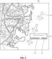
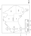
- FIG. 2 and 3 illustrates an example digital map that can be displayed within a viewport on the computing device 12 in a respective scenario, along with a window including suggested geographic places for directly repositioning the viewport and a schematic depiction of continuous movement of the viewport.
- the determination of the trajectory of a viewport, selection of candidate geographic places, and selection of suggestions from among the candidate geographic places are discussed primarily with reference to the place suggestion module 44 operating in the user device 12. It will be understood, however, that at least some of these techniques can be implemented in the map data server 60 or another suitable network device or group of network devices.
- the geographic application 42 can display a digital map of a part of Sydney, Australia in a viewport 100. More particularly, the viewport 100 corresponds to a certain zoom level, or level of magnification at which geographic features are depicted.
- the geographic area that is currently viewable within the viewport 100 lies on the trajectory defined by the continuous movement of the viewport 100, schematically illustrated in Fig. 2 by arrows 102. For example, the user may have swiped the viewport 100 in the direction of the arrows 102 three times in quick succession, and the place suggestion module 44 can detect substantially continuous movement of the viewport 100.
- the place suggestion module 44 in this example scenario determines which geographic places are on the trajectory of the arrows 102 in view of the zoom level of the viewport 100. For example, the place suggestion module 44 can consider geographic places which will be visible at some point if the user continues to pan the viewport 100 in the direction of the arrows 102 a certain number of times M (e.g., 10, 15, 20), each instance of panning advancing the viewport by a certain fixed amount.
- M e.g. 10, 15, 20
- the fixed amount in this example can correspond to the width of the geographic area covered by the viewport 100, which is approximately six miles (10 km), and the value of M can be ten.
- the place suggestion module 44 can consider candidate geographic places that will be visible at some point if the user pans the viewport ten more times, advancing the viewport by approximately 60 miles (100 km).
- the maximum distance within which candidate geographic places should be considered can be determined as a function of the zoom level: 10 miles (16 km) for zoom level Z N , 20 miles (32 km) for zoom level Z N-1 , 40 miles (64 km) for zoom level Z N-2 , etc. More generally, the place suggestion module 44 can select a certain maximum distance for repositioning the viewport in view of the current zoom level of the viewport 100.
- the place suggestion module 44 considers geographic places within approximately 60 miles (96.5 km) of Sydney, in the direction of the arrows 102. Because numerous geographic places matching these two criteria can be found, the place suggestion module 44 can select, from among multiple candidate geographic places, those locations that are more likely to be of interest to the user.
- the place suggestion module 44 can consider any combination of one or several factors such as, for example, the population of a city or town, the size of the area covered by the city or town, how frequently users request navigation directions to the place, rating or reviews available for the place, other indications of popularity of the place, similarity of the place to what is currently being displayed within the viewport, etc. For example, if the user is currently viewing the map a city in the viewport, the place suggestion module 44 may prioritize cities when selecting geographic places from among the candidate geographic places, and if the user is currently viewing the map of a national park, the place suggestion module 44 may prioritize parks when selecting geographic places from among the candidate geographic places.
- the place suggestion module 44 can compare candidate geographic places to the geographic place displayed within the viewport when the viewport originally started moving in the direction of the arrow 102, at the point when the place suggestion module 44 determines that the movement is substantially continuous, or at some intermediate point between these two points.
- the place suggestion module 44 in some scenarios can consider user-specific factors such as whether the user previously visited the visited the place or searched for the place, for example.
- the user in some embodiments operates certain controls and/or installs certain applications to allow the place suggestion module 44 to utilize the user's profile data in this manner. It is noted that only some of these factors may be applicable to certain geographic places.
- the place suggestion module 44 generates an overlay window 104 in which links to Royal National Park 110 and Wollongong 112, both located in the general direction indicated by the arrows 102 within the sixty-mile radius of Sydney, are displayed.
- the place suggestion module 44 can select Wollongong from among various geographic places located in the general direction indicated by the arrows 102 within the sixty-mile radius of Sydney, based at least in part on the relatively large size of this city, and Royal National Park because of its popularity.
- the geographic application 42 can reposition the viewport 100 directly over Royal National Park or Wollongong, respectively.
- the place suggestion module 44 allows the user to directly "jump" to a geographic place rather than continue to pan the viewport 100.
- a viewport 150 includes a map of the entire Australian continent.
- the place suggestion module 44 in this scenario detects continuous movement of the viewport 150 when the user pans the viewport 150 in the direction of arrows 152. Because the viewport 150 in this example corresponds to a much lower level of magnification (i.e., lower zoom level) than the viewport 100 of Fig. 2 , the place suggestion module 44 can consider candidate geographic locations within a longer distance. Accordingly, as illustrated in Fig. 3 , the place suggestion module 44 can generate an overlay window 154 in which selectable links to Philippines (160), South Korea (162), and Japan (164 ) are provided. The place suggestion module 44 can select Philippines, South Korea, and Japan based on the sizes of these geographic entities, for example. Additionally or alternatively, the place suggestion module 44 can suggest entire countries as geographic places because the viewport 150 currently covers the entire Australian continent.
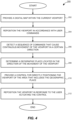
- Fig. 4 illustrates a flow diagram of an example method 200 for generating an interactive control for repositioning a viewport based on continuous movement of the viewport.
- the method 200 can be implemented in the place suggestion module 44 and/or the place determination module 46, for example.
- the method 200 begins at block 202, where a digital map of a geographic area is provided within a current viewport.
- the viewport is repositioned in accordance with user commands.
- the viewport can be panned on a touchscreen in response to a swipe gesture. The repositioning can occur multiple times in response to multiple user commands.
- a substantially continuous movement of the viewport is detected. More particularly, a sequence of similar user commands that cause such movement of the viewport can be detected. Referring back to the Fig. 2 , for example, multiple pan commands that cause the viewport 100 to move in the direction of the arrows 102 are detected. In general, the sequence of similar user commands can be configured to include any suitable number such as three, four, seven, etc. Further, additional conditions may be enforced at block 206, such as the requirement that the direction of movement of the viewport which the user communicates with gesture not deviate from a straight line by more than five degrees after executing any of the viewport movement commands in the sequence.
- At block 208 at least one geographic place located in the direction of the movement of the viewport is selected.
- a trajectory of the viewport can be estimated, several candidate geographic places can be selected in view at least of the zoom level of the viewport (to limit the distance within which geographic places are considered), and one or several suggestions are selected from among the candidate geographic places.
- candidate geographic places can include smaller towns of Coledale, Woonona, Spring Hill, etc., can be considered, but Wollongong can be selected as a suggestion for repositioning the viewport because of the size of Wollongong.
- one or several geographic places can be suggested.
- a control for quickly directly positioning the viewport over one of the suggested geographic places is provided.
- the control can be provided in the form of a selectable link within an overlay window such as the window 104 or 154.
- the viewport is directly positioned over the selected geographic place in response to the user operating the control.
- the viewport "jumps" to the new location without displaying map images for any intermediate geographic areas.
- the viewport appears to "fly over" the intermediate geographic area to provide an animation effect.
- the geographic application may omit some of the details, such as labels, minor features, point-of-interest icons, etc. for the areas over which the viewport flies over, thereby preserving processing power, memory, and bandwidth if the memory data arrives from a network server (such as the map data server 60).
- Modules may constitute either software modules (e.g., code embodied on a machine-readable medium or in a transmission signal) or hardware modules.
- a hardware module is tangible unit capable of performing certain operations and may be configured or arranged in a certain manner.
- one or more computer systems e.g., a standalone, client or server computer system
- one or more hardware modules of a computer system e.g., a processor or a group of processors
- software e.g., an application or application portion
- any reference to "one embodiment” or “an embodiment” means that a particular element, feature, structure, or characteristic described in connection with the embodiment is included in at least one embodiment.
- the appearances of the phrase “in one embodiment” in various places in the specification are not necessarily all referring to the same embodiment.
- Coupled and “connected” along with their derivatives.
- some embodiments may be described using the term “coupled” to indicate that two or more elements are in direct physical or electrical contact.
- the term “coupled,” however, may also mean that two or more elements are not in direct contact with each other, but yet still co-operate or interact with each other.
- the embodiments are not limited in this context.
- the terms “comprises,” “comprising,” “includes,” “including,” “has,” “having” or any other variation thereof, are intended to cover a non-exclusive inclusion.
- a process, method, article, or apparatus that comprises a list of elements is not necessarily limited to only those elements but may include other elements not expressly listed or inherent to such process, method, article, or apparatus.
- “or” refers to an inclusive or and not to an exclusive or. For example, a condition A or B is satisfied by any one of the following: A is true (or present) and B is false (or not present), A is false (or not present) and B is true (or present), and both A and B are true (or present).
Landscapes
- Engineering & Computer Science (AREA)
- Physics & Mathematics (AREA)
- Theoretical Computer Science (AREA)
- General Physics & Mathematics (AREA)
- Radar, Positioning & Navigation (AREA)
- Remote Sensing (AREA)
- Educational Administration (AREA)
- Mathematical Physics (AREA)
- Business, Economics & Management (AREA)
- Educational Technology (AREA)
- General Engineering & Computer Science (AREA)
- Automation & Control Theory (AREA)
- Human Computer Interaction (AREA)
- User Interface Of Digital Computer (AREA)
- Instructional Devices (AREA)
Claims (9)
- Procédé permettant de fournir des commandes d'utilisateur interactives dans une application géographique, le procédé comprenant :la fourniture (202), par un ou plusieurs processeurs (14) par l'intermédiaire d'une interface utilisateur (22), d'une carte numérique d'une zone géographique dans une fenêtre d'affichage (100, 150), ladite fenêtre d'affichage (100, 150) définissant une partie visible de la carte numérique ;le repositionnement (204), par le ou les processeurs (14), de la fenêtre d'affichage (100, 150) par rapport à la carte numérique conformément aux instructions d'utilisateur fournies par l'intermédiaire de l'interface utilisateur (22) ;en réponse à la détection (206), par le ou les processeurs (14), d'une séquence d'instructions d'utilisateur qui entraînent un mouvement continu de la fenêtre d'affichage (100, 150) dans une direction générale, la détermination (208), par le ou les processeurs (14), d'un lieu géographique situé dans la direction générale du mouvement continu de la fenêtre d'affichage (100, 150), ledit lieu géographique étant situé à l'extérieur de la zone géographique représentée par la carte numérique fournie dans la fenêtre d'affichage (100, 150) ; etla fourniture (210), par le ou les processeurs (14) par l'intermédiaire de l'interface utilisateur (22), d'une commande interactive destinée à positionner directement la fenêtre d'affichage (100, 150) sur une partie de la carte numérique représentant le lieu géographique.
- Procédé selon la revendication 1, ladite détection (206) de la séquence d'instructions d'utilisateur qui entraînent le mouvement continu comprenant la détection, par le ou les processeurs (14), d'une pluralité de gestes de balayage consécutifs appliqués à l'interface utilisateur (22) dans une direction sensiblement identique.
- Procédé selon la revendication 1, ladite détection (206) de la séquence d'instructions d'utilisateur qui entraînent le mouvement continu comprenant la détection, par le ou les processeurs (14), d'une pluralité de clics de souris consécutifs appliqués à une commande de direction affichée sur l'interface utilisateur (22).
- Procédé selon la revendication 1, ladite détermination (208) du lieu géographique comprenant la détermination, par le ou les processeurs (14), d'une trajectoire probable de la fenêtre d'affichage (100, 150) correspondant à un mouvement continu de la fenêtre d'affichage (100, 150) dans la direction du mouvement continu de la fenêtre d'affichage (100, 150), ledit lieu géographique étant sur la trajectoire probable de la fenêtre d'affichage (100, 150).
- Procédé selon la revendication 4,un niveau de zoom de la fenêtre d'affichage (100, 150) restant le même durant le mouvement continu, etladite détermination de la trajectoire comprenant la détermination d'une longueur de la trajectoire probable compte tenu du niveau de zoom.
- Procédé selon la revendication 4, ladite détermination du lieu géographique comprenant en outre :la détermination, par le ou les processeurs (14), d'une pluralité de lieux géographiques candidats sur la trajectoire, etla sélection, par le ou les processeurs, du lieu géographique parmi la pluralité de lieux géographiques candidats sur la base d'au moins un parmi (i) la popularité du lieu géographique, (ii) la zone associée au lieu géographique mesuré, et (iii) la population associée au lieu géographique.
- Procédé selon la revendication 1, ladite fourniture de la commande pour positionner directement la fenêtre d'affichage (100, 150) sur la partie de la carte numérique représentant le lieu géographique comprenant :
la fourniture, par le ou les processeurs (14), d'une fenêtre superposée (104, 154) sur la carte numérique, comprenant la fourniture d'un lien sélectionnable (110, 112, 160, 162, 164) vers un nouvel emplacement de la fenêtre d'affichage (100, 150) à l'intérieur de la fenêtre de superposition (104, 154). - Procédé selon la revendication 7, comprenant en outre :
la fourniture, dans la fenêtre de superposition (104, 154), d'une pluralité de liens sélectionnables (110, 112, 160, 162, 164) correspondant à une pluralité de lieux géographiques respectifs. - Dispositif informatique comprenant :une interface utilisateur (22) configurée pour afficher un contenu et recevoir une entrée utilisateur ;un ou plusieurs processeurs (14) couplés à l'interface utilisateur (22) ; etun support lisible par ordinateur non transitoire sur lequel sont stockées des instructions qui, lorsqu'elles sont exécutées par le ou les processeurs (14), amènent le dispositif informatique à réaliser le procédé selon l'une quelconque des revendications 1 à 8.
Applications Claiming Priority (2)
| Application Number | Priority Date | Filing Date | Title |
|---|---|---|---|
| US14/462,307 US9684425B2 (en) | 2014-08-18 | 2014-08-18 | Suggesting a target location upon viewport movement |
| PCT/US2015/045487 WO2016028674A1 (fr) | 2014-08-18 | 2015-08-17 | Suggestion de site cible lors d'un mouvement de fenêtre d'affichage |
Publications (2)
| Publication Number | Publication Date |
|---|---|
| EP3183641A1 EP3183641A1 (fr) | 2017-06-28 |
| EP3183641B1 true EP3183641B1 (fr) | 2023-06-07 |
Family
ID=54008027
Family Applications (1)
| Application Number | Title | Priority Date | Filing Date |
|---|---|---|---|
| EP15754393.5A Active EP3183641B1 (fr) | 2014-08-18 | 2015-08-17 | Suggestion de site cible lors d'un mouvement de fenêtre d'affichage |
Country Status (5)
| Country | Link |
|---|---|
| US (1) | US9684425B2 (fr) |
| EP (1) | EP3183641B1 (fr) |
| CN (1) | CN107077268B (fr) |
| DE (1) | DE202015009164U1 (fr) |
| WO (1) | WO2016028674A1 (fr) |
Families Citing this family (7)
| Publication number | Priority date | Publication date | Assignee | Title |
|---|---|---|---|---|
| US9903735B2 (en) | 2015-03-30 | 2018-02-27 | International Business Machines Corporation | Route stabilization scrolling mode |
| US10209871B2 (en) * | 2015-10-21 | 2019-02-19 | International Business Machines Corporation | Two-dimensional indication in contents |
| US10817167B2 (en) | 2016-09-15 | 2020-10-27 | Microsoft Technology Licensing, Llc | Device, method and computer program product for creating viewable content on an interactive display using gesture inputs indicating desired effects |
| AU2017397651B2 (en) * | 2017-08-04 | 2022-05-12 | Google Llc | Providing navigation directions |
| US11315296B2 (en) * | 2017-11-22 | 2022-04-26 | Google Llc | Dynamically varying visual properties of indicators on a digital map |
| US11328223B2 (en) * | 2019-07-22 | 2022-05-10 | Panasonic Intellectual Property Corporation Of America | Information processing method and information processing system |
| JP7535845B2 (ja) * | 2019-07-22 | 2024-08-19 | パナソニック インテレクチュアル プロパティ コーポレーション オブ アメリカ | 情報処理方法及び情報処理システム |
Family Cites Families (46)
| Publication number | Priority date | Publication date | Assignee | Title |
|---|---|---|---|---|
| EP1090273B1 (fr) | 1998-05-05 | 2012-11-14 | MITAC International Corporation | Indicateur directionnel pour faire défiler une carte dans un système de navigation |
| US6178380B1 (en) | 1998-10-22 | 2001-01-23 | Magellan, Dis, Inc. | Street identification for a map zoom of a navigation system |
| US6292743B1 (en) * | 1999-01-06 | 2001-09-18 | Infogation Corporation | Mobile navigation system |
| US7412514B2 (en) | 2000-08-17 | 2008-08-12 | Hoshiko Llc | Method and apparatus for improving bandwidth efficiency in a computer network |
| US7839926B1 (en) | 2000-11-17 | 2010-11-23 | Metzger Raymond R | Bandwidth management and control |
| JP3618303B2 (ja) * | 2001-04-24 | 2005-02-09 | 松下電器産業株式会社 | 地図表示装置 |
| JP2004272217A (ja) | 2003-02-18 | 2004-09-30 | Canon Inc | 地図画像表示制御方法およびそのプログラムおよびそのプログラムを記憶する記憶媒体および電子機器 |
| US20050177305A1 (en) | 2004-02-06 | 2005-08-11 | Han Maung W. | Display method and apparatus for navigation system |
| US10198521B2 (en) | 2005-06-27 | 2019-02-05 | Google Llc | Processing ambiguous search requests in a geographic information system |
| US7634354B2 (en) | 2005-08-31 | 2009-12-15 | Microsoft Corporation | Location signposting and orientation |
| ATE409307T1 (de) * | 2006-03-31 | 2008-10-15 | Research In Motion Ltd | Benutzerschnittstellenverfahren und vorrichtung zur steuerung der visuellen anzeige von karten mit auswählbaren kartenelementen bei mobilen kommunikationsvorrichtungen |
| EP1840511B1 (fr) | 2006-03-31 | 2016-03-02 | BlackBerry Limited | Procédés et appareil pour récupérer et afficher des données liées à une carte pour les cartes affichées visuellement dans des dispositifs de communication portables |
| DE602006010025D1 (de) | 2006-03-31 | 2009-12-10 | Research In Motion Ltd | Verfahren und Vorrichtung zur dynamischen Kennzeichnung von Kartenobjekten in visuell angezeigten Karten mobiler Kommunikationsvorrichtungen |
| US8626637B1 (en) | 2006-09-28 | 2014-01-07 | Gfi Group, Inc. | Apparatus, method and system for providing an electronic marketplace to join a trade for credit default swaps and other financial interests, and to deal-by-volume for the interests |
| AU2008204559A1 (en) | 2007-01-10 | 2008-07-17 | Tomtom International B.V. | Navigation device and method |
| KR20100005152A (ko) * | 2007-05-30 | 2010-01-13 | 가부시키가이샤 나비타이무쟈판 | 지도 표시 시스템, 지도 표시 장치 및 지도 표시 방법 |
| US7986319B2 (en) | 2007-08-01 | 2011-07-26 | Austin Gemodeling, Inc. | Method and system for dynamic, three-dimensional geological interpretation and modeling |
| US20090055087A1 (en) * | 2007-08-07 | 2009-02-26 | Brandon Graham Beacher | Methods and systems for displaying and automatic dynamic re-displaying of points of interest with graphic image |
| US8479105B2 (en) | 2008-03-24 | 2013-07-02 | International Business Machines Corporation | Managing graphical user interface objects in a computing environment |
| US8014943B2 (en) * | 2008-05-08 | 2011-09-06 | Gabriel Jakobson | Method and system for displaying social networking navigation information |
| US8032297B2 (en) | 2008-05-08 | 2011-10-04 | Gabriel Jakobson | Method and system for displaying navigation information on an electronic map |
| CN102187694A (zh) | 2008-05-28 | 2011-09-14 | 谷歌公司 | 在移动计算设备上的运动控制的视图 |
| US8060582B2 (en) | 2008-10-22 | 2011-11-15 | Google Inc. | Geocoding personal information |
| US20100115459A1 (en) * | 2008-10-31 | 2010-05-06 | Nokia Corporation | Method, apparatus and computer program product for providing expedited navigation |
| WO2010087750A1 (fr) | 2009-01-30 | 2010-08-05 | Telefonaktiebolaget L M Ericsson (Publ) | Présentation d'une carte numérique |
| US8806331B2 (en) | 2009-07-20 | 2014-08-12 | Interactive Memories, Inc. | System and methods for creating and editing photo-based projects on a digital network |
| US8433512B1 (en) * | 2009-11-12 | 2013-04-30 | Google Inc. | Enhanced identification of interesting points-of-interest |
| JP2011191651A (ja) * | 2010-03-16 | 2011-09-29 | Clarion Co Ltd | 地図表示装置 |
| JP5230684B2 (ja) * | 2010-05-13 | 2013-07-10 | パナソニック株式会社 | 電子機器、表示方法、及びプログラム |
| US20120032974A1 (en) | 2010-08-04 | 2012-02-09 | Lynch Phillip C | Method and apparatus for map panning recall |
| US8976744B2 (en) | 2010-11-03 | 2015-03-10 | Broadcom Corporation | Vehicle communication network including wireless communications |
| US9049238B2 (en) | 2011-04-26 | 2015-06-02 | Jeffrey Scuba | System for creating anonymous social gatherings |
| US9285991B2 (en) | 2011-04-29 | 2016-03-15 | International Business Machines Corporation | System, method and program product to schedule transfer of data |
| US8676937B2 (en) | 2011-05-12 | 2014-03-18 | Jeffrey Alan Rapaport | Social-topical adaptive networking (STAN) system allowing for group based contextual transaction offers and acceptances and hot topic watchdogging |
| GB2492381A (en) * | 2011-06-30 | 2013-01-02 | Tomtom Int Bv | Controlling a map displayed on a navigation apparatus in order to maximise the display of a remaining route |
| US8274524B1 (en) | 2011-09-28 | 2012-09-25 | Google Inc. | Map rendering using interpolation of style parameters across zoom levels |
| US8538956B1 (en) | 2011-09-28 | 2013-09-17 | Google Inc. | Geocoding results using geotopic annotation of web search results |
| US20130093750A1 (en) | 2011-10-12 | 2013-04-18 | Google Inc. | Use of banding to optimize map rendering in a three-dimensional tilt view |
| US8532919B2 (en) * | 2011-12-26 | 2013-09-10 | TrackThings LLC | Method and apparatus of physically moving a portable unit to view an image of a stationary map |
| US20130257742A1 (en) * | 2012-03-28 | 2013-10-03 | Google Inc. | Method and System for Controlling Imagery Panning Based on Displayed Content |
| US8671106B1 (en) | 2012-05-23 | 2014-03-11 | Google Inc. | Indicators for entities corresponding to search suggestions |
| US9135751B2 (en) * | 2012-06-05 | 2015-09-15 | Apple Inc. | Displaying location preview |
| TWI472720B (zh) * | 2012-08-22 | 2015-02-11 | Inst Information Industry | 興趣點資訊地圖呈現系統、方法及其記錄媒體 |
| US8589818B1 (en) | 2013-01-03 | 2013-11-19 | Google Inc. | Moveable viewport for indicating off-screen content |
| EP2804096B1 (fr) * | 2013-05-15 | 2018-03-21 | Google LLC | Extraction efficace de données cartographiques pendant une animation |
| US9429432B2 (en) * | 2013-06-06 | 2016-08-30 | Duke University | Systems and methods for defining a geographic position of an object or event based on a geographic position of a computing device and a user gesture |
-
2014
- 2014-08-18 US US14/462,307 patent/US9684425B2/en active Active
-
2015
- 2015-08-17 EP EP15754393.5A patent/EP3183641B1/fr active Active
- 2015-08-17 CN CN201580056380.3A patent/CN107077268B/zh active Active
- 2015-08-17 DE DE202015009164.4U patent/DE202015009164U1/de not_active Expired - Lifetime
- 2015-08-17 WO PCT/US2015/045487 patent/WO2016028674A1/fr not_active Ceased
Also Published As
| Publication number | Publication date |
|---|---|
| US9684425B2 (en) | 2017-06-20 |
| WO2016028674A1 (fr) | 2016-02-25 |
| US20160048282A1 (en) | 2016-02-18 |
| CN107077268A (zh) | 2017-08-18 |
| CN107077268B (zh) | 2021-02-02 |
| DE202015009164U1 (de) | 2016-11-07 |
| EP3183641A1 (fr) | 2017-06-28 |
Similar Documents
| Publication | Publication Date | Title |
|---|---|---|
| EP3183641B1 (fr) | Suggestion de site cible lors d'un mouvement de fenêtre d'affichage | |
| EP3635339B1 (fr) | Modification dynamique de propriétés visuelles d'indicateurs sur une carte numérique | |
| US10359294B2 (en) | Interactive digital map on a portable device | |
| US9110573B2 (en) | Personalized viewports for interactive digital maps | |
| EP2984548B1 (fr) | Système et procédé pour une désambiguïsation de sélection d'article | |
| EP3566023B1 (fr) | Fourniture automatique de directions de navigation sur une carte numérique interactive | |
| US20190271545A1 (en) | Stack of maps | |
| US20160116296A1 (en) | Providing instant routing options | |
| KR20110068683A (ko) | 파노라마 이미지를 디스플레이하는 방법 | |
| US10198164B1 (en) | Triggering location selector interface by continuous zooming | |
| EP3124915A1 (fr) | Procédé pour faire fonctionner un dispositif de navigation | |
| CN118210421A (zh) | 目标轨迹缩放方法、设备和计算机可读存储介质 |
Legal Events
| Date | Code | Title | Description |
|---|---|---|---|
| STAA | Information on the status of an ep patent application or granted ep patent |
Free format text: STATUS: THE INTERNATIONAL PUBLICATION HAS BEEN MADE |
|
| PUAI | Public reference made under article 153(3) epc to a published international application that has entered the european phase |
Free format text: ORIGINAL CODE: 0009012 |
|
| STAA | Information on the status of an ep patent application or granted ep patent |
Free format text: STATUS: REQUEST FOR EXAMINATION WAS MADE |
|
| 17P | Request for examination filed |
Effective date: 20170303 |
|
| AK | Designated contracting states |
Kind code of ref document: A1 Designated state(s): AL AT BE BG CH CY CZ DE DK EE ES FI FR GB GR HR HU IE IS IT LI LT LU LV MC MK MT NL NO PL PT RO RS SE SI SK SM TR |
|
| AX | Request for extension of the european patent |
Extension state: BA ME |
|
| RAP1 | Party data changed (applicant data changed or rights of an application transferred) |
Owner name: GOOGLE LLC |
|
| DAV | Request for validation of the european patent (deleted) | ||
| DAX | Request for extension of the european patent (deleted) | ||
| STAA | Information on the status of an ep patent application or granted ep patent |
Free format text: STATUS: EXAMINATION IS IN PROGRESS |
|
| 17Q | First examination report despatched |
Effective date: 20190321 |
|
| GRAP | Despatch of communication of intention to grant a patent |
Free format text: ORIGINAL CODE: EPIDOSNIGR1 |
|
| STAA | Information on the status of an ep patent application or granted ep patent |
Free format text: STATUS: GRANT OF PATENT IS INTENDED |
|
| INTG | Intention to grant announced |
Effective date: 20221215 |
|
| GRAS | Grant fee paid |
Free format text: ORIGINAL CODE: EPIDOSNIGR3 |
|
| GRAA | (expected) grant |
Free format text: ORIGINAL CODE: 0009210 |
|
| STAA | Information on the status of an ep patent application or granted ep patent |
Free format text: STATUS: THE PATENT HAS BEEN GRANTED |
|
| AK | Designated contracting states |
Kind code of ref document: B1 Designated state(s): AL AT BE BG CH CY CZ DE DK EE ES FI FR GB GR HR HU IE IS IT LI LT LU LV MC MK MT NL NO PL PT RO RS SE SI SK SM TR |
|
| REG | Reference to a national code |
Ref country code: GB Ref legal event code: FG4D |
|
| REG | Reference to a national code |
Ref country code: CH Ref legal event code: EP Ref country code: AT Ref legal event code: REF Ref document number: 1577045 Country of ref document: AT Kind code of ref document: T Effective date: 20230615 |
|
| REG | Reference to a national code |
Ref country code: DE Ref legal event code: R096 Ref document number: 602015083892 Country of ref document: DE |
|
| P01 | Opt-out of the competence of the unified patent court (upc) registered |
Effective date: 20230719 |
|
| REG | Reference to a national code |
Ref country code: LT Ref legal event code: MG9D |
|
| REG | Reference to a national code |
Ref country code: NL Ref legal event code: MP Effective date: 20230607 |
|
| PG25 | Lapsed in a contracting state [announced via postgrant information from national office to epo] |
Ref country code: SE Free format text: LAPSE BECAUSE OF FAILURE TO SUBMIT A TRANSLATION OF THE DESCRIPTION OR TO PAY THE FEE WITHIN THE PRESCRIBED TIME-LIMIT Effective date: 20230607 Ref country code: NO Free format text: LAPSE BECAUSE OF FAILURE TO SUBMIT A TRANSLATION OF THE DESCRIPTION OR TO PAY THE FEE WITHIN THE PRESCRIBED TIME-LIMIT Effective date: 20230907 Ref country code: ES Free format text: LAPSE BECAUSE OF FAILURE TO SUBMIT A TRANSLATION OF THE DESCRIPTION OR TO PAY THE FEE WITHIN THE PRESCRIBED TIME-LIMIT Effective date: 20230607 |
|
| REG | Reference to a national code |
Ref country code: AT Ref legal event code: MK05 Ref document number: 1577045 Country of ref document: AT Kind code of ref document: T Effective date: 20230607 |
|
| PG25 | Lapsed in a contracting state [announced via postgrant information from national office to epo] |
Ref country code: RS Free format text: LAPSE BECAUSE OF FAILURE TO SUBMIT A TRANSLATION OF THE DESCRIPTION OR TO PAY THE FEE WITHIN THE PRESCRIBED TIME-LIMIT Effective date: 20230607 Ref country code: NL Free format text: LAPSE BECAUSE OF FAILURE TO SUBMIT A TRANSLATION OF THE DESCRIPTION OR TO PAY THE FEE WITHIN THE PRESCRIBED TIME-LIMIT Effective date: 20230607 Ref country code: LV Free format text: LAPSE BECAUSE OF FAILURE TO SUBMIT A TRANSLATION OF THE DESCRIPTION OR TO PAY THE FEE WITHIN THE PRESCRIBED TIME-LIMIT Effective date: 20230607 Ref country code: LT Free format text: LAPSE BECAUSE OF FAILURE TO SUBMIT A TRANSLATION OF THE DESCRIPTION OR TO PAY THE FEE WITHIN THE PRESCRIBED TIME-LIMIT Effective date: 20230607 Ref country code: HR Free format text: LAPSE BECAUSE OF FAILURE TO SUBMIT A TRANSLATION OF THE DESCRIPTION OR TO PAY THE FEE WITHIN THE PRESCRIBED TIME-LIMIT Effective date: 20230607 Ref country code: GR Free format text: LAPSE BECAUSE OF FAILURE TO SUBMIT A TRANSLATION OF THE DESCRIPTION OR TO PAY THE FEE WITHIN THE PRESCRIBED TIME-LIMIT Effective date: 20230908 |
|
| PG25 | Lapsed in a contracting state [announced via postgrant information from national office to epo] |
Ref country code: FI Free format text: LAPSE BECAUSE OF FAILURE TO SUBMIT A TRANSLATION OF THE DESCRIPTION OR TO PAY THE FEE WITHIN THE PRESCRIBED TIME-LIMIT Effective date: 20230607 |
|
| PG25 | Lapsed in a contracting state [announced via postgrant information from national office to epo] |
Ref country code: SK Free format text: LAPSE BECAUSE OF FAILURE TO SUBMIT A TRANSLATION OF THE DESCRIPTION OR TO PAY THE FEE WITHIN THE PRESCRIBED TIME-LIMIT Effective date: 20230607 |
|
| PG25 | Lapsed in a contracting state [announced via postgrant information from national office to epo] |
Ref country code: IS Free format text: LAPSE BECAUSE OF FAILURE TO SUBMIT A TRANSLATION OF THE DESCRIPTION OR TO PAY THE FEE WITHIN THE PRESCRIBED TIME-LIMIT Effective date: 20231007 |
|
| PG25 | Lapsed in a contracting state [announced via postgrant information from national office to epo] |
Ref country code: SM Free format text: LAPSE BECAUSE OF FAILURE TO SUBMIT A TRANSLATION OF THE DESCRIPTION OR TO PAY THE FEE WITHIN THE PRESCRIBED TIME-LIMIT Effective date: 20230607 Ref country code: SK Free format text: LAPSE BECAUSE OF FAILURE TO SUBMIT A TRANSLATION OF THE DESCRIPTION OR TO PAY THE FEE WITHIN THE PRESCRIBED TIME-LIMIT Effective date: 20230607 Ref country code: RO Free format text: LAPSE BECAUSE OF FAILURE TO SUBMIT A TRANSLATION OF THE DESCRIPTION OR TO PAY THE FEE WITHIN THE PRESCRIBED TIME-LIMIT Effective date: 20230607 Ref country code: PT Free format text: LAPSE BECAUSE OF FAILURE TO SUBMIT A TRANSLATION OF THE DESCRIPTION OR TO PAY THE FEE WITHIN THE PRESCRIBED TIME-LIMIT Effective date: 20231009 Ref country code: IS Free format text: LAPSE BECAUSE OF FAILURE TO SUBMIT A TRANSLATION OF THE DESCRIPTION OR TO PAY THE FEE WITHIN THE PRESCRIBED TIME-LIMIT Effective date: 20231007 Ref country code: EE Free format text: LAPSE BECAUSE OF FAILURE TO SUBMIT A TRANSLATION OF THE DESCRIPTION OR TO PAY THE FEE WITHIN THE PRESCRIBED TIME-LIMIT Effective date: 20230607 Ref country code: CZ Free format text: LAPSE BECAUSE OF FAILURE TO SUBMIT A TRANSLATION OF THE DESCRIPTION OR TO PAY THE FEE WITHIN THE PRESCRIBED TIME-LIMIT Effective date: 20230607 Ref country code: AT Free format text: LAPSE BECAUSE OF FAILURE TO SUBMIT A TRANSLATION OF THE DESCRIPTION OR TO PAY THE FEE WITHIN THE PRESCRIBED TIME-LIMIT Effective date: 20230607 |
|
| PG25 | Lapsed in a contracting state [announced via postgrant information from national office to epo] |
Ref country code: PL Free format text: LAPSE BECAUSE OF FAILURE TO SUBMIT A TRANSLATION OF THE DESCRIPTION OR TO PAY THE FEE WITHIN THE PRESCRIBED TIME-LIMIT Effective date: 20230607 |
|
| REG | Reference to a national code |
Ref country code: DE Ref legal event code: R097 Ref document number: 602015083892 Country of ref document: DE |
|
| PG25 | Lapsed in a contracting state [announced via postgrant information from national office to epo] |
Ref country code: MC Free format text: LAPSE BECAUSE OF FAILURE TO SUBMIT A TRANSLATION OF THE DESCRIPTION OR TO PAY THE FEE WITHIN THE PRESCRIBED TIME-LIMIT Effective date: 20230607 |
|
| REG | Reference to a national code |
Ref country code: CH Ref legal event code: PL |
|
| PG25 | Lapsed in a contracting state [announced via postgrant information from national office to epo] |
Ref country code: MC Free format text: LAPSE BECAUSE OF FAILURE TO SUBMIT A TRANSLATION OF THE DESCRIPTION OR TO PAY THE FEE WITHIN THE PRESCRIBED TIME-LIMIT Effective date: 20230607 |
|
| PLBE | No opposition filed within time limit |
Free format text: ORIGINAL CODE: 0009261 |
|
| STAA | Information on the status of an ep patent application or granted ep patent |
Free format text: STATUS: NO OPPOSITION FILED WITHIN TIME LIMIT |
|
| PG25 | Lapsed in a contracting state [announced via postgrant information from national office to epo] |
Ref country code: LU Free format text: LAPSE BECAUSE OF NON-PAYMENT OF DUE FEES Effective date: 20230817 |
|
| PG25 | Lapsed in a contracting state [announced via postgrant information from national office to epo] |
Ref country code: LU Free format text: LAPSE BECAUSE OF NON-PAYMENT OF DUE FEES Effective date: 20230817 Ref country code: DK Free format text: LAPSE BECAUSE OF FAILURE TO SUBMIT A TRANSLATION OF THE DESCRIPTION OR TO PAY THE FEE WITHIN THE PRESCRIBED TIME-LIMIT Effective date: 20230607 Ref country code: CH Free format text: LAPSE BECAUSE OF NON-PAYMENT OF DUE FEES Effective date: 20230831 |
|
| PG25 | Lapsed in a contracting state [announced via postgrant information from national office to epo] |
Ref country code: SI Free format text: LAPSE BECAUSE OF FAILURE TO SUBMIT A TRANSLATION OF THE DESCRIPTION OR TO PAY THE FEE WITHIN THE PRESCRIBED TIME-LIMIT Effective date: 20230607 |
|
| REG | Reference to a national code |
Ref country code: BE Ref legal event code: MM Effective date: 20230831 |
|
| 26N | No opposition filed |
Effective date: 20240308 |
|
| REG | Reference to a national code |
Ref country code: IE Ref legal event code: MM4A |
|
| PG25 | Lapsed in a contracting state [announced via postgrant information from national office to epo] |
Ref country code: SI Free format text: LAPSE BECAUSE OF FAILURE TO SUBMIT A TRANSLATION OF THE DESCRIPTION OR TO PAY THE FEE WITHIN THE PRESCRIBED TIME-LIMIT Effective date: 20230607 Ref country code: IT Free format text: LAPSE BECAUSE OF FAILURE TO SUBMIT A TRANSLATION OF THE DESCRIPTION OR TO PAY THE FEE WITHIN THE PRESCRIBED TIME-LIMIT Effective date: 20230607 |
|
| PG25 | Lapsed in a contracting state [announced via postgrant information from national office to epo] |
Ref country code: IE Free format text: LAPSE BECAUSE OF NON-PAYMENT OF DUE FEES Effective date: 20230817 |
|
| PG25 | Lapsed in a contracting state [announced via postgrant information from national office to epo] |
Ref country code: IE Free format text: LAPSE BECAUSE OF NON-PAYMENT OF DUE FEES Effective date: 20230817 |
|
| PG25 | Lapsed in a contracting state [announced via postgrant information from national office to epo] |
Ref country code: BE Free format text: LAPSE BECAUSE OF NON-PAYMENT OF DUE FEES Effective date: 20230831 |
|
| PG25 | Lapsed in a contracting state [announced via postgrant information from national office to epo] |
Ref country code: BG Free format text: LAPSE BECAUSE OF FAILURE TO SUBMIT A TRANSLATION OF THE DESCRIPTION OR TO PAY THE FEE WITHIN THE PRESCRIBED TIME-LIMIT Effective date: 20230607 |
|
| PG25 | Lapsed in a contracting state [announced via postgrant information from national office to epo] |
Ref country code: BG Free format text: LAPSE BECAUSE OF FAILURE TO SUBMIT A TRANSLATION OF THE DESCRIPTION OR TO PAY THE FEE WITHIN THE PRESCRIBED TIME-LIMIT Effective date: 20230607 |
|
| PG25 | Lapsed in a contracting state [announced via postgrant information from national office to epo] |
Ref country code: CY Free format text: LAPSE BECAUSE OF FAILURE TO SUBMIT A TRANSLATION OF THE DESCRIPTION OR TO PAY THE FEE WITHIN THE PRESCRIBED TIME-LIMIT; INVALID AB INITIO Effective date: 20150817 |
|
| PG25 | Lapsed in a contracting state [announced via postgrant information from national office to epo] |
Ref country code: HU Free format text: LAPSE BECAUSE OF FAILURE TO SUBMIT A TRANSLATION OF THE DESCRIPTION OR TO PAY THE FEE WITHIN THE PRESCRIBED TIME-LIMIT; INVALID AB INITIO Effective date: 20150817 |
|
| PGFP | Annual fee paid to national office [announced via postgrant information from national office to epo] |
Ref country code: DE Payment date: 20250827 Year of fee payment: 11 |
|
| PGFP | Annual fee paid to national office [announced via postgrant information from national office to epo] |
Ref country code: GB Payment date: 20250827 Year of fee payment: 11 |
|
| PGFP | Annual fee paid to national office [announced via postgrant information from national office to epo] |
Ref country code: FR Payment date: 20250825 Year of fee payment: 11 |
|
| PG25 | Lapsed in a contracting state [announced via postgrant information from national office to epo] |
Ref country code: TR Free format text: LAPSE BECAUSE OF FAILURE TO SUBMIT A TRANSLATION OF THE DESCRIPTION OR TO PAY THE FEE WITHIN THE PRESCRIBED TIME-LIMIT Effective date: 20230607 |