EP3214406A1 - Procédé et système d'utilisation d'un historique de route - Google Patents
Procédé et système d'utilisation d'un historique de route Download PDFInfo
- Publication number
- EP3214406A1 EP3214406A1 EP16158691.2A EP16158691A EP3214406A1 EP 3214406 A1 EP3214406 A1 EP 3214406A1 EP 16158691 A EP16158691 A EP 16158691A EP 3214406 A1 EP3214406 A1 EP 3214406A1
- Authority
- EP
- European Patent Office
- Prior art keywords
- trip
- destination
- data
- mapping database
- original position
- Prior art date
- Legal status (The legal status is an assumption and is not a legal conclusion. Google has not performed a legal analysis and makes no representation as to the accuracy of the status listed.)
- Withdrawn
Links
Images


Classifications
-
- G—PHYSICS
- G01—MEASURING; TESTING
- G01C—MEASURING DISTANCES, LEVELS OR BEARINGS; SURVEYING; NAVIGATION; GYROSCOPIC INSTRUMENTS; PHOTOGRAMMETRY OR VIDEOGRAMMETRY
- G01C21/00—Navigation; Navigational instruments not provided for in groups G01C1/00 - G01C19/00
- G01C21/26—Navigation; Navigational instruments not provided for in groups G01C1/00 - G01C19/00 specially adapted for navigation in a road network
- G01C21/34—Route searching; Route guidance
- G01C21/36—Input/output arrangements for on-board computers
- G01C21/3605—Destination input or retrieval
- G01C21/3617—Destination input or retrieval using user history, behaviour, conditions or preferences, e.g. predicted or inferred from previous use or current movement
-
- G—PHYSICS
- G01—MEASURING; TESTING
- G01C—MEASURING DISTANCES, LEVELS OR BEARINGS; SURVEYING; NAVIGATION; GYROSCOPIC INSTRUMENTS; PHOTOGRAMMETRY OR VIDEOGRAMMETRY
- G01C21/00—Navigation; Navigational instruments not provided for in groups G01C1/00 - G01C19/00
- G01C21/26—Navigation; Navigational instruments not provided for in groups G01C1/00 - G01C19/00 specially adapted for navigation in a road network
- G01C21/34—Route searching; Route guidance
- G01C21/3453—Special cost functions, i.e. other than distance or default speed limit of road segments
- G01C21/3484—Personalized, e.g. from learned user behaviour or user-defined profiles
-
- G—PHYSICS
- G01—MEASURING; TESTING
- G01C—MEASURING DISTANCES, LEVELS OR BEARINGS; SURVEYING; NAVIGATION; GYROSCOPIC INSTRUMENTS; PHOTOGRAMMETRY OR VIDEOGRAMMETRY
- G01C21/00—Navigation; Navigational instruments not provided for in groups G01C1/00 - G01C19/00
- G01C21/38—Electronic maps specially adapted for navigation; Updating thereof
- G01C21/3804—Creation or updating of map data
- G01C21/3833—Creation or updating of map data characterised by the source of data
- G01C21/3837—Data obtained from a single source
Definitions
- the present disclosure relates to a method for utilizing a trip history, which method is performed by a system being comprised in a navigation device on-board a vehicle during a trip from an original position to a destination.
- the disclosure further relates to a system for utilizing a trip history, a destination prediction system and a vehicle comprising the system.
- the current driving route and destination prediction methods are using the history of driving GPS data which can also be connected with additional metadata, e.g. describing characteristics of trip such as driver-id, number of passengers, time-of-say, day-of-week.
- the predictability of the model will be reduced if the prior information is not modelled properly and the conditions are equally weighted for all destinations. Additional issue with the existing methods is that they are not flexible in adding or removing features or prior information. And to adapt it with new features, the algorithm should be re-trained again for all recorded data.
- the object of the present disclosure is to overcome or ameliorate at least one of the disadvantages of the prior art, or to provide a useful alternative.
- a method for utilizing a trip history is performed by a system comprised in a navigation device on-board an vehicle during a trip from an original position to a destination.
- the method comprises the steps of
- the method for utilizing a trip history as disclosed herein describes a method suitable for data collection to be used for destination prediction in a vehicle.
- the method may be performed by a system, e.g. the system for utilizing a trip history as disclosed herein, which is comprised in a navigation device.
- the navigation device may be comprised in the vehicle. Alternatively, or as a complement, the navigation device may be a separate mobile device, which can be placed and used in the vehicle.
- the original position also called the origin, defines where the trip starts. It may be a parking lot, e.g. outside a home of the user of the vehicle, a place of work, a school, a shop, a mall, a sport facility or an entertainment facility.
- the destination defines where the trip ends.
- it may be a parking lot, e.g. outside a home of the user of the vehicle, a place of work, a school, a shop, a shopping mall, a sport facility or an entertainment facility.
- a trip is supposed to be ended, when the vehicle has been standing still for a preselected time, e.g. 5 minutes. This may be decided by means of the positioning determining unit. As an alternative, or a complement, a trip may be supposed to be ended when the ignition of the vehicle is turned off.
- the positioning determining unit may use a satellite positioning system, such as GPS, i.e. Global Positioning System.
- GPS Global Positioning System
- the mapping database comprises information about roads at least in an area, in which the trip is taking place.
- the mapping database may also comprise additional information about possible destinations, such as residential areas, places of work, schools, shops, shopping malls, sports facilities and/or entertainment facilities.
- the mapping database may cover a city, a county or a country.
- a plurality of mapping databases may be combined with each other.
- the information of the database may be stored on a computer-readable medium to be used in the vehicle, or the information of the mapping database may be stored in a central location and transmitted to the navigation device.
- the mapping database is mainly used as source for a road graph map, and thus the additional information mentioned above may be dispensed with.
- the method may thus be carried out, although there is no available information about the physical meaning of a place.
- the road graph map may be utilized to provide information about the density of the road graphs, which can help to understand the density of that location.
- the concept of density is then used for the destination clustering. That means that the destinations, which are nearby, may be grouped together and the closeness measure may be related to the density of the road graph. Purely as an example, for an area, which has low density, it may be assumed that at that place there is a possibility to park at larger distance from a specific destination.
- the mapping database e.g. the road graph map
- the mapping database is used to determine a road segment, which fits with the determined position.
- the road segment is associated to the determined position. If the fit is not exact, the closest road segment may be selected.
- a current position is determined, which is compared to the mapping database and a road segment is associated to the determined current position. Thereafter the road segment is set as a link of the trip.
- a road comprises one or more road segments, following after each other along the road.
- the road segment may e.g. extend between two intersections of the road being used as nodes. See the below description of nodes for further examples.
- a road or a portion of a road having no intersections may be divided into road segments. The division may depend on the structure of the mapping database and may e.g. relate to an interspace given in metres.
- a link as utilized in the method described herein corresponds to a road segment.
- the link may further comprise information about the running direction for vehicles on that road segment.
- the road segments are used as links, such that the link corresponds to a road segment.
- the links may be represented in a road graph representation of the route used during the trip. This may be done by using a model, in which each unit of the road graph representation is represented with a link between two nodes. The position of the nodes is taken from the mapping database.
- the link may extend between two intersections of a road system or between an intersection and a possible original position or destination, such as a house in a residential area, a place of work, a school, a shop, a shopping mall, a sport facility or an entertainment facility.
- Nodes can represent:
- mapping database may use different nodes.
- intersection comprises any road-crossing or branching-off, wherein it is possible to select between two or more alternative roads.
- the intersection may be two roads crossing, i.e. intersecting, at about 90 degrees.
- the angle may also be different from 90 degrees, such as e.g. a highway exit, a Y-crossing or a T-crossing.
- Two or more determined positions may be associated to the same road segment or link, if no node has been passed, since the last link was determined.
- one current position is determined after the other, forming a series of determined positions and thereby also a series of connected links.
- the trip is represented as the series of connected links, which links were passed during the trip.
- the series of links may be represented as a road graph representation.
- the method as described herein may also be performed for at least one other trip having another original position, another destination and/or utilizing other roads.
- the method as described herein may be performed for at least one trip being performed at another trip characteristic than a first trip, e.g. regarding time of day, day of week, time duration of trip, season, number of passengers, fuel level and/or battery level.
- the route may be the same as being used before, but at least one trip characteristic may have been changed.
- the method may comprise storing trip data, e.g. in a hash table, as data sets.
- the storing step may be performed stepwise in parallel to any one of the steps a-I mentioned above, i.e. when making the trip, or it may be performed after step I, i.e. when the trip is finished.
- a data set of the trip data may comprise information of the original position, the destination and the series of connected links between the original position and/or the destination. The method as described herein is then used for collecting trip data.
- a hash table structure is a data structure suitable for an associative array implementation.
- the hash table supports insertion, deletion, and search in average-case constant time which provides an efficient way of mapping and accessing data.
- Its data structure is similar to a table structure in which each entry has a key.
- it makes sense to use a hash table with the links as hash keys, where the hash values are the connected links and destinations.
- it makes sense to use a hash table with origins as key and destinations from each origin as hash values.
- the data set of the trip data may also comprise information about a number of times a certain trip has been performed. Thereby frequently used routes will have a higher number.
- the trip data may also comprise information about a trip characteristic, e.g. regarding time of day, day of week, time duration of trip, season, number of passengers, fuel level and/or battery level.
- trip characteristics are parameters describing characteristics of a trip, also referred to as prior information.
- Data of one or more trip characteristics may be stored.
- the trip characteristics may be stored in a hash table with origins as key and destinations from each origin as hash values, the trip characteristics being stored along with destinations as hash values.
- a new trip characteristic also after data collection has started. Data having been collected before the new trip characteristic was added may then be associated with a default value for the added new trip characteristic.
- the stored trip data may be used for destination prediction.
- the method may then comprise associating a probability for a next link and a destination given a current link, wherein the probability is based on the stored trip data.
- the predicted destination is selected from destinations of the stored trip data.
- Statistical models such as probabilistic Bayesian models, may be employed to analyse stored trip data.
- a probabilistic model of prior information i.e. trip characteristics
- probabilistic models such as Bayesian modls, in which statistical properties of prior information are considered in the prediction, may be employed. Taking into account the statistical properties of prior information in the destination prediction improves the performance of the prediction.
- the method may comprise updating the probability during a trip, for which trip the destination is predicted. For example, assume an intersection, from which there are at least two different roads leading to at least two different possible destination, and one of the two roads is selected by the user of the vehicle, then the probability for a destination, which is reached by the non-selected road, may be set to zero, and the probabilities for the remaining possible destinations may be updated accordingly.
- existing data sets of the stored trip data may be utilized by applying weight factors. Thereby, stored data sets having trip characteristics being close to the hitherto unobserved trip characteristic may have a greater weight than stored data sets having trip characteristics being far from the hitherto unobserved trip characteristic.
- the method may comprise storing trip data associated to an individual user.
- the user is normally the same person as the driver.
- the vehicle is a partially automated, semi-automated or fully automated vehicle, in which case the user may not be driving the vehicle.
- a driver of the vehicle performs some of the driving functions, while the vehicle autonomously performs other functions. If the vehicle is fully automated, the vehicle autonomously performs the driving functions, at least for a temporary period of time.
- a vehicle may be arranged to be able to change between driving manually, partially automated, semi-automated and/or fully automated.
- the stored trip data may also comprise at least one operation parameter of the vehicle, such as velocity, orientation, gas pedal opening rate, brake pressure, steering angle.
- the method may comprise the possibility to remove at least one of the data sets of the stored trip data if irrelevant.
- data may become irrelevant if the user e.g. moves to a new home, changes place of work or school and/or switches to a new shop thereby no longer buying in the old shop.
- the irrelevant trip data may be gradually phased out, e.g. if it is observed that a specific trip is no longer being performed.
- the relevancy may be determined by determining the periodicity of driving to that destination.
- the system comprises
- the system for utilizing a trip history is adapted to perform the method as described herein.
- the system may be comprised in a destination prediction system, which also comprises a unit for predicting the destination based on the stored trip data.
- a vehicle comprising the system for utilizing a trip history as disclosed herein and/or the destination prediction system.
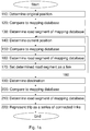
- Figure 1 a illustrates a method according to the invention. The method comprises the steps of
- the method may be performed by a system 500 for utilizing a trip history as described in conjunction with Figure 2 below, which system is comprised in a navigation device.
- the navigation device may be comprised in the vehicle. Alternatively, or as a complement, the navigation device may be a separate mobile device, which can be placed and used in the vehicle.
- Figure 1b illustrates another method according to the invention.
- the method of Figure 1b includes the steps of Figure 1 a. It further comprises a step 300 of storing trip data, e.g. in a hash table, as data sets.
- the storing step 300 may be performed stepwise in parallel to any one of the steps 110-220 mentioned above, i.e. when making the trip, or it may be performed after step 220 of Figure 1 a , as is illustrated in Figure 1 b , i.e. when the trip is finished.
- a data set of the trip data may comprise information of the original position, the destination and the series of connected links between the original position and/or the destination. The method as described herein is then used for collecting trip data.
- the data set of the trip data may also comprise information about a number of times a certain trip has been performed. Thereby frequently used routes will have a higher number.
- the trip data may also comprise information about a trip characteristic, e.g. regarding time of day, day of week, time duration of trip, season, number of passengers, fuel level and/or battery level.
- a trip characteristic e.g. regarding time of day, day of week, time duration of trip, season, number of passengers, fuel level and/or battery level.
- One or more trip characteristics may be stored.
- a new trip characteristic also after data collection has started. Data, having been collected before the new trip characteristic was added, may then be associated with a default value for the added new trip characteristic.
- Figure 1c illustrates yet another method according to the invention.
- the method of Figure 1c includes the steps of Figure 1 b. It further comprises a step 400 of associating a probability for a next link and a destination given a current link, wherein the probability is based on the stored trip data. Once data has been collected, the stored trip data may be used for destination prediction. The predicted destination is selected from destinations of the stored trip data.
- the method may, as an option, comprise a step 410 of updating the probability during a trip, for which trip the destination is predicted. For example, assume an intersection, from which there are at least two different roads leading to at least two different possible destination, and one of the two roads is selected by the user of the vehicle, then the probability for a destination, which is reached by the non-selected road, may be set to zero, and the probabilities for the remaining possible destinations may be updated accordingly.
- Figure 2 schematically illustrates a system 500 for utilizing a trip history, the trip going from an original position to a destination.
- the system 500 comprises
- the system 500 for utilizing a trip history is adapted to perform the method as described herein.
- the system may be comprised in a destination prediction system, which also comprises a unit 540 for predicting the destination based on the stored trip data.
- the example illustrates a way of performing the method for utilizing a trip history according to the invention.
- the example further describes a prediction method, as is also disclosed herein, and a system for utilizing a trip history and for estimating a driver's intended route and destination.
- the focus of this example is to develop a practical route and destination prediction method by utilizing history of logged GPS data for individual drivers.
- Data analysis and model training are performed on GPS traces captured sequentially over time and additional data describing trip characteristics. For each trip, first the end location is detected, then it will be either added to one of the existing destination clusters or generate a new cluster. For this trip, the road-mapped GPS traces and other metadata are analysed to update the training model which is used to predict the most probable route and destinations at each segment of the route during driving.
- the data attributes are GPS signals collected from portable GPS receivers installed in the car.
- the road graph representation of the mapping database is used for the analysis.
- GPS data are matched to the mapping database, which results in road graph representations of the routes.
- each unit of the road graph is represented with a link between two nodes.
- the two node-ids are assigned in the direction of travel to each link. For example, a physical link (in a two-way) street between node a and b is represented with ab or ba depending on direction of travel.
- origin is denoted by o and destination by g.
- a trip is defined with sequence of links, l , which are identified with unique ids. Each trip starts with ignition on event at a GPS location corresponding to origin-cluster, o , and ends with ignition off event at a GPS location corresponding to destination cluster, g .
- Bayesian statistics are used for data modelling and analysis.
- P l x , g / l P l x / g , l P g / l .
- probabilistic graphical models are used to demonstrate dependency in structure between random variables.
- the simplicity in visualizing probabilistic models offers a powerful tool to represent dependencies and conditional independence in complicated models.
- each node represents a random variable, and edges between the nodes (links) represent probabilistic dependencies among corresponding random variables.
- Fig. 3a shows the Bayesian graphical model of equation (2).
- N repeated nodes are replaced with a single node in a plate, in which the number of nodes is indicated inside the plate, see Fig. 3c .
- the basic of the proposed approach is Markov model and follows first order Markov chain process.
- the prediction problem is defined as follows: given the history of driving (GPS trajectories from origins to destinations) and the current location of car, what is the next probable route and destination? That is, the state prediction is done for the destination g and next link l x in the road graph and the observations are the current link l and additional metadata describing trip characteristic. Thereby only observations at the origin are considered, which observations can include for instance the location of origin, number of passengers in the car, or time of travel. For the sake of representation in this section, these types of prior information are represented by o .
- the problem can be rephrased as a solution for P(g / l,o) and P(l x / l,o).
- the prior information is totally ignored or history of data is recorded for each pair of ⁇ l,o >. Therefore, the link observations are restricted to the origin.
- increasing parameters in prior without having sufficient observation, which can support the current observation will decrease the predictability of the model.
- a Bayesian model is introduced, in which statistical properties of priors are considered in the prediction.
- the transition probability to a destination given the origin and the current link can be written as P g
- l , o P l , o
- g P l
- g ⁇ P l
- g P g P l o multiplying by P g P g ⁇ P l
- g P g P l o P g from the Bayes theory P g
- Equation (3) P g
- l , o P g
- o P g i P g i P g P g
- o P g
- o P g
- o P g
- o P g
- o P g
- the transition probability to the next link is not only a function of history of driving but also it depends on destination. To impose the transition probability of destinations to the possible connected link, the probability of transition to the next link over the destinations is marginalized. That is, the probability of transition to the next link l x , given the origin o and the current link / is written as P l x
- l , o ⁇ i P l x , g i
- l , o ⁇ i P l x
- P(g i / l,o) is the transition probability to destination g i given the origin and the current link, calculated according to 4.
- equation (5) is rewritten as P l x
- l , o ⁇ i P l x
- a hash table structure is used that is a data structure suitable for an associative array implementation.
- the hash table supports insertion, deletion, and search in average-case constant time which provides an efficient way of mapping and accessing data.
- Its data structure is similar to table structure in which each entry has a key.
- data attributes are sequence of links to a destination, hence, it makes sense to use links as hash keys where the hash values are the connected links and destinations.
- the hash values are stored in table format which let the values to be updated and fields to be added.
- Each variable in a table can have a different data type and size with the one restriction that each variable must have the same number of rows. Given the proposed two hash table, all data historic required for predictions are efficiently summarized in the tables.
- the proposed prediction model in Section 3 uses only the prior information regarding origin. However, other prior information is also available at the time of travel which can be used to enhance the prediction performance.
- the proposed prediction model is the basic model when considering only origin as prior. In this case, it is possible to calculate the probability of traveling to each destination from the given origin by dividing number of times the destination is visited to the total number of destinations from that origin. The problem becomes more complicated when other data attributes are considered in the origin. For instance, calculating the probability of going to each destination given the current time and number of passengers.
- An alternative solution of using additional factors in predicting driver route and destination uses an algorithm in which the conditions were deterministically imposed into the problem (classical method). That is for each detected condition, the data was stored separately; and for prediction only data which was matched with the current condition would be used. However, the results are not necessarily better when including additional factors when the model is deterministic. In this case, not all the stored data are informative and the variable importance (the contribution of each variable to the model) is calculated based on the density of data for each condition.
- a new model which take into account the probabilistic model of this information is proposed in this example. That is a statistical model is built up indicating the probability of current condition being in previously observed conditions. For that, different clustering methods were evaluated, such as SVM (support vector machine), bagging, random trees, and random forest. Given the characteristics of the data in this example and advantages of random forest, it was decided to choose random forest as the clustering candidate [1].
- Random forests provide a measure of predictor relative importance by measuring the damage that would be done to predictive models with no access to true values of a given variable.
- attributes which can have significant influences when predicting the destination, such as time of departure, day of week, driver, number of passenger, fuel level, and so on.
- the proposed clustering solution is not dependent in number of parameters and is generalized for arbitrary factors.
- the Bayesian graphical representation of this predictive model is illustrated in Fig. 5 .
- Table 3 reports destinations driven from home, for a single driver during 6 months with 300 trips.
- destination 3 the second most visited location
- the histogram of two attributes time-of-day and day-of-week
- Fig. 6a and Fig. 6b the histogram of two attributes (time-of-day and day-of-week) are plotted in Fig. 6a and Fig. 6b .
- trip started between 6 and 10 is denoted by 610, between 10 and 15 with 1015, between 15 and 18 with 1518, and between 18 and 24 with 1824.
- weekend is denoted by 0 and working days by 1.
- the random forest classifier was applied to this dataset when having both time-of-day and weekday as destination attributes. The resulted variable importance is reported in Table 4.
- the estimated probability matrix using the random forest is depicted in Fig. 8 .
- all the destinations are correctly predicted except 12.
- this destination is only travelled three times where there are not any patterns detected in the time and day attributes (their corresponding variable importance is zero). Then the reported variables in probability matrix are used as a prior (P(g / o)) in (4).
- DBSCAN is an abbreviation for density-based spatial clustering of applications with noise. While the original DBSCAN clustering algorithm uses a global threshold as a closeness measure in data space, a method to set local thresholds values for data points is developed in this example; this is important because the GPS data proximity strongly depends on the density of the street grid around each point. Specifically, the spread of GPS coordinates in parking lots can vary substantially between narrow (personal parking lot) and wide (parking lot of a shopping mall) depending on the destinations.
- the local threshold values are inferred from road graph density using a mapping database.
- a mutual reachability constraint to preserve the insensitivity of DBSCAN with respect to the ordering of the points is proposed.
- the performance of the proposed clustering algorithm has been evaluated extensively using trips of actual cars in Sweden, and some of the results are presented here.
- data attributes are geographical information corresponding to stationary GPS traces collected prior to end-of-trip.
- a trip starts from an ignition-on event at a location corresponding to an origin cluster and ends by an ignition-off event at a location corresponding to a destination cluster.
- a cluster is a group of data that share a set of similar properties.
- data attributes are numeric (GPS locations) where the similarity between two data object can be judged based on a distance measure.
- GPS locations numeric (GPS locations) where the similarity between two data object can be judged based on a distance measure.
- the number of clusters is not known in advance and data points are sequentially increasing over time.
- a choice to use DBSCAN-based clustering algorithms was made because of their ability in discovering clusters with arbitrary shapes and processing large databases efficiently.
- the original DBSCAN [2] algorithm and its variations have been widely used for clustering spatial data.
- the similarity measures are either defined globally in data space or determined locally based on density of data at different regions.
- finding appropriate threshold value as a closeness measure can be very challenging depending on the location of the parking lot, which is independent of density of previously collected data at each region. Therefore, the current density-based algorithms do not provide a complete solution in our application considering the region-based clusters specifications.
- clusters are formed by all points that are density-reachable from each other, i.e. connected through an unbroken chain of directly density-reachable points.
- a point p is directly density-reachable from a point q , if q has a minimum number of points (defined as minPts ) including p within a distance threshold of ⁇ .
- minPts minimum number of points
- ⁇ distance threshold
- the minPts and ⁇ values are given as global parameters into DBSCAN.
- the set of all points that are directly density-reachable from q is called the ⁇ -neighborhood of q . All points which are not density-reachable from any other point are classified as noise.
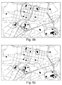
- Fig. 9a and Fig. 9b show the results of DBSCAN clustering in a subset of GPS coordinates for one user centred in the town of Alings ⁇ s (vicinity of 5km 2 ) .
- the minPts value was set to 3 for both of these examples.
- the destination clusters correspond well to the self-identified activities of the user, except in the lower right corner, where two parking lots belonging to the same building are clustered as separate destinations.
- the ⁇ parameter is increased to 200 m, see Fig. 9b .
- resulting destinations are highly dependent on properties of parking lots areas (density of the street grid around these point), which cannot be captured using only one global ⁇ value.
- the first step is to modify the DBSCAN algorithm by defining an individual density threshold for each data point.
- the second step is to identify those thresholds using knowledge of the problem domain.
- N ⁇ (p) ⁇ q ⁇ D / dist(p,q) ⁇ ⁇ p ,dist(p,q) ⁇ ⁇ q ⁇ . That is p and q should be reachable from both directions to be considered members of the same neighbourhood.
- the run time efficiency of the DBSCAN is retained by performing the region query with ⁇ p and subsequently excluding results that do not fulfil the condition dist(p,q) ⁇ ⁇ q .
- the ⁇ -bonds and their corresponding (two)-breakpoints for the density values are set intuitively according to the data.
- the density values below and above the breakpoints are set to the lower and upper ⁇ -bonds respectively, resulting in the application of the original DBSCAN algorithm on those points.
- Fig. 9c shows resulting clusters when applying the proposed algorithm of this example, referred to as the map-based local DBSCAN (ML-DBSCAN), to the same dataset.
- the first and second break-points are set to 100 and 200, respectively, using the radius of 500 m, and the lower and upper bounds are set to 100 m and 200 m, respectively.
Landscapes
- Engineering & Computer Science (AREA)
- Radar, Positioning & Navigation (AREA)
- Remote Sensing (AREA)
- Automation & Control Theory (AREA)
- Physics & Mathematics (AREA)
- General Physics & Mathematics (AREA)
- Health & Medical Sciences (AREA)
- General Health & Medical Sciences (AREA)
- Social Psychology (AREA)
- Navigation (AREA)
- Traffic Control Systems (AREA)
Priority Applications (3)
| Application Number | Priority Date | Filing Date | Title |
|---|---|---|---|
| EP16158691.2A EP3214406A1 (fr) | 2016-03-04 | 2016-03-04 | Procédé et système d'utilisation d'un historique de route |
| US15/441,689 US10578451B2 (en) | 2016-03-04 | 2017-02-24 | Method and system for utilizing a trip history to predict a destination |
| US16/736,090 US11378411B2 (en) | 2016-03-04 | 2020-01-07 | Method and system for utilizing a trip history to predict a destination |
Applications Claiming Priority (1)
| Application Number | Priority Date | Filing Date | Title |
|---|---|---|---|
| EP16158691.2A EP3214406A1 (fr) | 2016-03-04 | 2016-03-04 | Procédé et système d'utilisation d'un historique de route |
Publications (1)
| Publication Number | Publication Date |
|---|---|
| EP3214406A1 true EP3214406A1 (fr) | 2017-09-06 |
Family
ID=55456702
Family Applications (1)
| Application Number | Title | Priority Date | Filing Date |
|---|---|---|---|
| EP16158691.2A Withdrawn EP3214406A1 (fr) | 2016-03-04 | 2016-03-04 | Procédé et système d'utilisation d'un historique de route |
Country Status (2)
| Country | Link |
|---|---|
| US (2) | US10578451B2 (fr) |
| EP (1) | EP3214406A1 (fr) |
Cited By (4)
| Publication number | Priority date | Publication date | Assignee | Title |
|---|---|---|---|---|
| CN107818382A (zh) * | 2017-10-27 | 2018-03-20 | 中航信移动科技有限公司 | 航班到达时间预测方法 |
| CN110750605A (zh) * | 2019-09-09 | 2020-02-04 | 西安工程大学 | 运动场景下多情境特征的手机用户下一地点预测方法 |
| US11079238B2 (en) | 2018-11-28 | 2021-08-03 | International Business Machines Corporation | Calculating a most probable path |
| CN115565376A (zh) * | 2022-09-30 | 2023-01-03 | 福州大学 | 融合graph2vec、双层LSTM的车辆行程时间预测方法及系统 |
Families Citing this family (20)
| Publication number | Priority date | Publication date | Assignee | Title |
|---|---|---|---|---|
| US10401187B2 (en) * | 2016-07-15 | 2019-09-03 | Here Global B.V. | Method, apparatus and computer program product for a navigation system user interface |
| JP7010637B2 (ja) * | 2017-09-22 | 2022-01-26 | トヨタ自動車株式会社 | 情報処理システム、情報処理装置、方法、及びプログラム |
| US10929713B2 (en) * | 2017-10-17 | 2021-02-23 | Sri International | Semantic visual landmarks for navigation |
| KR102056696B1 (ko) * | 2017-11-09 | 2019-12-17 | 숭실대학교 산학협력단 | 사용자 행위 데이터를 생성하기 위한 단말 장치, 사용자 행위 데이터 생성 방법 및 기록매체 |
| CN108764375B (zh) * | 2018-06-25 | 2019-05-03 | 交通运输部科学研究院 | 高速公路货运车辆跨省匹配方法及装置 |
| JP2020112917A (ja) * | 2019-01-09 | 2020-07-27 | 日本電信電話株式会社 | 目的地予測装置、方法、及びプログラム |
| US11294936B1 (en) | 2019-01-30 | 2022-04-05 | Snap Inc. | Adaptive spatial density based clustering |
| US12242979B1 (en) * | 2019-03-12 | 2025-03-04 | Snap Inc. | Departure time estimation in a location sharing system |
| US11852554B1 (en) | 2019-03-21 | 2023-12-26 | Snap Inc. | Barometer calibration in a location sharing system |
| US11166123B1 (en) | 2019-03-28 | 2021-11-02 | Snap Inc. | Grouped transmission of location data in a location sharing system |
| US10809074B1 (en) * | 2019-06-04 | 2020-10-20 | Here Global B.V. | Method, apparatus, and computer program product for map data agnostic route fingerprints |
| CN111121803B (zh) * | 2019-11-27 | 2021-12-03 | 北京中交兴路信息科技有限公司 | 获取道路常用停靠点的方法及装置 |
| CN111586951B (zh) * | 2020-04-30 | 2021-09-14 | 珠海格力电器股份有限公司 | 酒店照明装置的控制方法、控制装置、系统及存储介质 |
| EP3943890B1 (fr) | 2020-07-23 | 2023-05-03 | Fujitsu Limited | Procédé mis en oeuvre par ordinateur permettant de prédire la consommation d'énergie d'un itinéraire |
| EP3971780A1 (fr) * | 2020-07-24 | 2022-03-23 | Tata Consultancy Services Limited | Procédé et système de prédiction dynamique de l'heure d'arrivée d'un véhicule à l'aide d'une technique d'apprentissage de différence temporelle |
| CN113535871B (zh) * | 2021-06-25 | 2024-02-27 | 杨粤湘 | 基于出行图谱的车辆目的地预测方法、装置、设备及介质 |
| US12072197B2 (en) * | 2022-05-31 | 2024-08-27 | Allstate Insurance Company | System and method for identifying trip similarities |
| DE102022123212A1 (de) | 2022-09-12 | 2024-03-14 | Bayerische Motoren Werke Aktiengesellschaft | Vorrichtung und Verfahren zur prädiktiven Ermittlung von Zwischenzielen einer Route |
| US20250078517A1 (en) * | 2023-09-04 | 2025-03-06 | Yolanda Latrice Lyons | Public Safety Technology Scanner System and Related Methods |
| US20250377213A1 (en) | 2024-06-07 | 2025-12-11 | GM Global Technology Operations LLC | System and method for predicting a destination for a vehicle |
Citations (7)
| Publication number | Priority date | Publication date | Assignee | Title |
|---|---|---|---|---|
| EP1551195A1 (fr) * | 2002-10-10 | 2005-07-06 | Matsushita Electric Industrial Co., Ltd. | Procede d'acquisition d'informations, procede de distribution d'informations et dispositif d'acquisition d'informations |
| DE102006057920A1 (de) * | 2006-12-08 | 2008-06-12 | Volkswagen Ag | Verfahren zum Steuern der Anzeige eines Navigationssystems in einem Modus, bei dem keine Route und kein Ziel eingegeben ist |
| EP2080984A1 (fr) * | 2007-05-02 | 2009-07-22 | Panasonic Corporation | Dispositif d'estimation de destination, procédé d'estimation de destination et dispositif de navigation |
| US20100010733A1 (en) * | 2008-07-09 | 2010-01-14 | Microsoft Corporation | Route prediction |
| EP2369299A1 (fr) * | 2010-03-24 | 2011-09-28 | Sap Ag | Dispositif de navigation et procédé de prédiction de la destination d'un voyage |
| US20130179070A1 (en) * | 2012-01-09 | 2013-07-11 | Ford Global Technologies, Llc | Adaptive method for trip prediction |
| US20150134244A1 (en) * | 2013-11-12 | 2015-05-14 | Mitsubishi Electric Research Laboratories, Inc. | Method for Predicting Travel Destinations Based on Historical Data |
Family Cites Families (36)
| Publication number | Priority date | Publication date | Assignee | Title |
|---|---|---|---|---|
| US6317686B1 (en) * | 2000-07-21 | 2001-11-13 | Bin Ran | Method of providing travel time |
| JP4497748B2 (ja) * | 2001-04-27 | 2010-07-07 | パイオニア株式会社 | ナビゲーション装置、ナビゲーションシステム用のサーバ装置、目的地推定処理プログラムおよび目的地推定処理プログラムを記録した記録媒体 |
| EP1380813B1 (fr) * | 2001-08-06 | 2012-05-02 | Panasonic Corporation | Procede et dispositif permettant de fournir des informations |
| JP2005031068A (ja) * | 2003-06-20 | 2005-02-03 | Matsushita Electric Ind Co Ltd | 場所案内装置 |
| US7463972B2 (en) * | 2003-09-26 | 2008-12-09 | Aisin Aw Co., Ltd. | Navigation apparatus and method |
| US7233861B2 (en) * | 2003-12-08 | 2007-06-19 | General Motors Corporation | Prediction of vehicle operator destinations |
| US20050228553A1 (en) * | 2004-03-30 | 2005-10-13 | Williams International Co., L.L.C. | Hybrid Electric Vehicle Energy Management System |
| JP4470589B2 (ja) * | 2004-05-31 | 2010-06-02 | 日産自動車株式会社 | ナビゲーション装置と行程ステージに対応した情報の提示方法 |
| CN101040554B (zh) * | 2004-10-14 | 2010-05-05 | 松下电器产业株式会社 | 移动目标预测装置和移动目标预测方法 |
| US7925426B2 (en) * | 2005-11-17 | 2011-04-12 | Motility Systems | Power management systems and devices |
| JP4783181B2 (ja) * | 2006-03-13 | 2011-09-28 | 株式会社東芝 | 行動予測装置 |
| US7630828B2 (en) * | 2006-04-14 | 2009-12-08 | Panasonic Corporation | Destination prediction device and destination prediction method |
| JP4130847B2 (ja) * | 2006-09-28 | 2008-08-06 | 松下電器産業株式会社 | 移動先予測装置およびその方法 |
| US9497286B2 (en) * | 2007-07-07 | 2016-11-15 | Qualcomm Incorporated | Method and system for providing targeted information based on a user profile in a mobile environment |
| US9392074B2 (en) * | 2007-07-07 | 2016-07-12 | Qualcomm Incorporated | User profile generation architecture for mobile content-message targeting |
| US8660794B2 (en) * | 2007-07-13 | 2014-02-25 | Dash Navigation, Inc. | System and method for providing shared information about traveled road segments |
| US8577599B2 (en) * | 2008-06-30 | 2013-11-05 | General Motors Llc | Method and system to calculate historical traffic data |
| US8335647B2 (en) * | 2008-12-04 | 2012-12-18 | Verizon Patent And Licensing Inc. | Navigation based on popular user-defined paths |
| US8533726B2 (en) * | 2009-02-24 | 2013-09-10 | Nec Corporation | Device, system, method, and program for computing resource allocation based on external environment and transition frequency |
| US8271497B2 (en) * | 2009-12-03 | 2012-09-18 | Sony Computer Entertainment Inc. | Information processing apparatus and information processing method outputting information on movement of person |
| US8754777B1 (en) * | 2010-08-13 | 2014-06-17 | Google Inc. | System and method for predicting user route and destination |
| US8538677B2 (en) * | 2010-12-30 | 2013-09-17 | Telenav, Inc. | Navigation system with constrained resource route planning mechanism and method of operation thereof |
| US9163952B2 (en) * | 2011-04-15 | 2015-10-20 | Microsoft Technology Licensing, Llc | Suggestive mapping |
| US9958280B2 (en) * | 2011-08-16 | 2018-05-01 | Inrix, Inc. | Assessing inter-modal passenger travel options |
| US8892350B2 (en) * | 2011-12-16 | 2014-11-18 | Toyoda Jidosha Kabushiki Kaisha | Journey learning system |
| CN106408252B (zh) * | 2012-06-22 | 2019-11-29 | 谷歌有限责任公司 | 呈现针对当前位置或时间的信息 |
| CN104471350A (zh) * | 2012-07-17 | 2015-03-25 | 三菱电机株式会社 | 车载用交通信息通知装置 |
| GB201215385D0 (en) * | 2012-08-29 | 2012-10-10 | Tom Tom Int Bv | Method and apparatus for predicting destinations |
| US9219668B2 (en) * | 2012-10-19 | 2015-12-22 | Facebook, Inc. | Predicting the future state of a mobile device user |
| CN104995973B (zh) * | 2013-03-18 | 2020-08-11 | 英特尔公司 | 移动设备定位系统 |
| US9803990B2 (en) * | 2013-05-30 | 2017-10-31 | Oath (Americas) Inc. | Systems and methods for providing mobile mapping services including trip prediction and route recommendation |
| US9618343B2 (en) * | 2013-12-12 | 2017-04-11 | Microsoft Technology Licensing, Llc | Predicted travel intent |
| US20150339575A1 (en) * | 2014-05-21 | 2015-11-26 | Open Inference LLC | Inference engine |
| US9762601B2 (en) * | 2015-06-17 | 2017-09-12 | Uber Technologies, Inc. | Trip anomaly detection system |
| US20170017928A1 (en) * | 2015-07-15 | 2017-01-19 | Microsoft Technology Licensing, Llc | Inferring physical meeting location |
| US10976173B2 (en) * | 2017-07-14 | 2021-04-13 | Allstate Insurance Company | Distributed data processing systems for processing remotely captured sensor data |
-
2016
- 2016-03-04 EP EP16158691.2A patent/EP3214406A1/fr not_active Withdrawn
-
2017
- 2017-02-24 US US15/441,689 patent/US10578451B2/en active Active
-
2020
- 2020-01-07 US US16/736,090 patent/US11378411B2/en active Active
Patent Citations (7)
| Publication number | Priority date | Publication date | Assignee | Title |
|---|---|---|---|---|
| EP1551195A1 (fr) * | 2002-10-10 | 2005-07-06 | Matsushita Electric Industrial Co., Ltd. | Procede d'acquisition d'informations, procede de distribution d'informations et dispositif d'acquisition d'informations |
| DE102006057920A1 (de) * | 2006-12-08 | 2008-06-12 | Volkswagen Ag | Verfahren zum Steuern der Anzeige eines Navigationssystems in einem Modus, bei dem keine Route und kein Ziel eingegeben ist |
| EP2080984A1 (fr) * | 2007-05-02 | 2009-07-22 | Panasonic Corporation | Dispositif d'estimation de destination, procédé d'estimation de destination et dispositif de navigation |
| US20100010733A1 (en) * | 2008-07-09 | 2010-01-14 | Microsoft Corporation | Route prediction |
| EP2369299A1 (fr) * | 2010-03-24 | 2011-09-28 | Sap Ag | Dispositif de navigation et procédé de prédiction de la destination d'un voyage |
| US20130179070A1 (en) * | 2012-01-09 | 2013-07-11 | Ford Global Technologies, Llc | Adaptive method for trip prediction |
| US20150134244A1 (en) * | 2013-11-12 | 2015-05-14 | Mitsubishi Electric Research Laboratories, Inc. | Method for Predicting Travel Destinations Based on Historical Data |
Non-Patent Citations (7)
| Title |
|---|
| A. LIAW; M. WIENER: "Classification and regression by randomforest", R NEWS, vol. 2, no. 3, 2002, pages 18 - 22, XP055305332 |
| G. PANAHANDEH; N. AKERBLOM: "Clustering Driving Destinations Using a Modified DBSCAN Algorithm with Locally Defined Map-Based Thresholds", PROC. OF COMPUTATIONAL MULTI PHYSICS, MULTI SCALES AND MULTI BIG DATA IN TRANSPORT MODELING, SIMULATION AND OPTIMIZATION (CM3, 2015 |
| L. DUAN; L. XU; F. GUO; J. LEE; B. YAN: "A local-density based spatial clustering algorithm with noise", INFORMATION SYSTEMS, vol. 32, no. 7, 2007, pages 978 - 986, XP022144338, DOI: doi:10.1016/j.is.2006.10.006 |
| M. ANKERST; M. BREUNIG; H. KRIEGEL; J. SANDER: "Optics: ordering points to identify the clustering structure", ACM SIGMOD RECORD, vol. 28, 1999, pages 49 - 60, XP008144377 |
| M. ESTER; H. KRIEGEL; J. SANDER; X. XU: "A density-based algorithm for discovering clusters in large spatial databases with noise", PROCEEDINGS OF INTERNATIONAL CONFERENCE ON KNOWLEDGE DISCOVERY AND DATA MINING, 1996, pages 226 - 231, XP002355949 |
| PANAHANDEH GHAZALEH ET AL: "Clustering Driving Destinations Using a Modified DBSCAN Algorithm with Locally-Defined Map-Based Thresholds", COMPUTATIONAL MULTI PHYSICS, MULTI SCALES AND MULTI BIG DATA IN TRANSPORT MODELING, SIMULATION AND OPTIMIZATION, 25 May 2015 (2015-05-25), pages 97 - 103, XP055811513, Retrieved from the Internet <URL:https://link.springer.com/chapter/10.1007/978-3-319-54490-8_7#citeas> DOI: https://doi.org/10.1007/978-3-319-54490-8_7 * |
| S. KISILEVICH; F. MANSMANN; D. KEIM: "P-DBSCAN: a density based clustering algorithm for exploration and analysis of attractive areas using collections of geo-tagged photos", PROCEEDINGS OF INTERNATIONAL CONFERENCE AND EXHIBITION ON COMPUTING FOR GEOSPATIAL RESEARCH AND APPLICATION, 2010, pages 38 |
Cited By (6)
| Publication number | Priority date | Publication date | Assignee | Title |
|---|---|---|---|---|
| CN107818382A (zh) * | 2017-10-27 | 2018-03-20 | 中航信移动科技有限公司 | 航班到达时间预测方法 |
| CN107818382B (zh) * | 2017-10-27 | 2021-01-05 | 中航信移动科技有限公司 | 航班到达时间预测方法 |
| US11079238B2 (en) | 2018-11-28 | 2021-08-03 | International Business Machines Corporation | Calculating a most probable path |
| CN110750605A (zh) * | 2019-09-09 | 2020-02-04 | 西安工程大学 | 运动场景下多情境特征的手机用户下一地点预测方法 |
| CN115565376A (zh) * | 2022-09-30 | 2023-01-03 | 福州大学 | 融合graph2vec、双层LSTM的车辆行程时间预测方法及系统 |
| CN115565376B (zh) * | 2022-09-30 | 2024-05-03 | 福州大学 | 融合graph2vec、双层LSTM的车辆行程时间预测方法及系统 |
Also Published As
| Publication number | Publication date |
|---|---|
| US20200149914A1 (en) | 2020-05-14 |
| US10578451B2 (en) | 2020-03-03 |
| US11378411B2 (en) | 2022-07-05 |
| US20170254660A1 (en) | 2017-09-07 |
Similar Documents
| Publication | Publication Date | Title |
|---|---|---|
| US11378411B2 (en) | Method and system for utilizing a trip history to predict a destination | |
| Lv et al. | T-CONV: A convolutional neural network for multi-scale taxi trajectory prediction | |
| Provoost et al. | Predicting parking occupancy via machine learning in the web of things | |
| Li et al. | Go slow to go fast: minimal on-road time route scheduling with parking facilities using historical trajectory | |
| Yang et al. | Using incomplete information for complete weight annotation of road networks | |
| Yang et al. | Travel cost inference from sparse, spatio temporally correlated time series using markov models | |
| US10175054B2 (en) | Predicting and utilizing variability of travel times in mapping services | |
| Chen et al. | Mining moving patterns for predicting next location | |
| Wang et al. | Moving destination prediction using sparse dataset: A mobility gradient descent approach | |
| US20160125307A1 (en) | Air quality inference using multiple data sources | |
| US11435202B2 (en) | Trajectory sampling using spatial familiarity | |
| Alsahfi et al. | A survey on trajectory data warehouse | |
| Pecher et al. | Data-driven vehicle trajectory prediction | |
| Yang et al. | Did you enjoy the ride? understanding passenger experience via heterogeneous network embedding | |
| CN113763712A (zh) | 基于出行事件知识图谱的区域交通拥堵溯因方法 | |
| Lim Jr et al. | Determinants of household flood evacuation mode choice in a developing country | |
| Shekhar et al. | Benchmarking spatial big data | |
| Zhu et al. | Optimization approach to depot location in car sharing systems with big data | |
| Yu et al. | A hybrid prediction approach for road tunnel traffic based on spatial-temporary data fusion: A hybrid prediction approach for road tunnel traffic based on spatial-temporary data fusion | |
| Thu et al. | Multi-source data analysis for bike sharing systems | |
| Provoost et al. | Short term prediction of parking area states using real time data and machine learning techniques | |
| Panahandeh | Driver route and destination prediction | |
| Tabibiazar et al. | Kernel-based modeling and optimization for density estimation in transportation systems using floating car data | |
| Wang et al. | Influential spatial facility prediction over large scale cyber-physical vehicles in smart city | |
| Reijsbergen | Probabilistic modelling of station locations in bicycle-sharing systems |
Legal Events
| Date | Code | Title | Description |
|---|---|---|---|
| PUAI | Public reference made under article 153(3) epc to a published international application that has entered the european phase |
Free format text: ORIGINAL CODE: 0009012 |
|
| STAA | Information on the status of an ep patent application or granted ep patent |
Free format text: STATUS: THE APPLICATION HAS BEEN PUBLISHED |
|
| AK | Designated contracting states |
Kind code of ref document: A1 Designated state(s): AL AT BE BG CH CY CZ DE DK EE ES FI FR GB GR HR HU IE IS IT LI LT LU LV MC MK MT NL NO PL PT RO RS SE SI SK SM TR |
|
| AX | Request for extension of the european patent |
Extension state: BA ME |
|
| STAA | Information on the status of an ep patent application or granted ep patent |
Free format text: STATUS: REQUEST FOR EXAMINATION WAS MADE |
|
| 17P | Request for examination filed |
Effective date: 20180306 |
|
| RBV | Designated contracting states (corrected) |
Designated state(s): AL AT BE BG CH CY CZ DE DK EE ES FI FR GB GR HR HU IE IS IT LI LT LU LV MC MK MT NL NO PL PT RO RS SE SI SK SM TR |
|
| STAA | Information on the status of an ep patent application or granted ep patent |
Free format text: STATUS: EXAMINATION IS IN PROGRESS |
|
| 17Q | First examination report despatched |
Effective date: 20210615 |
|
| P01 | Opt-out of the competence of the unified patent court (upc) registered |
Effective date: 20230828 |
|
| STAA | Information on the status of an ep patent application or granted ep patent |
Free format text: STATUS: THE APPLICATION HAS BEEN WITHDRAWN |
|
| 18W | Application withdrawn |
Effective date: 20241028 |