EP3226031A1 - Laserscanner - Google Patents
Laserscanner Download PDFInfo
- Publication number
- EP3226031A1 EP3226031A1 EP17163391.0A EP17163391A EP3226031A1 EP 3226031 A1 EP3226031 A1 EP 3226031A1 EP 17163391 A EP17163391 A EP 17163391A EP 3226031 A1 EP3226031 A1 EP 3226031A1
- Authority
- EP
- European Patent Office
- Prior art keywords
- laser scanner
- scanner device
- view
- horizontal
- laser
- Prior art date
- Legal status (The legal status is an assumption and is not a legal conclusion. Google has not performed a legal analysis and makes no representation as to the accuracy of the status listed.)
- Ceased
Links
Images



Classifications
-
- G—PHYSICS
- G01—MEASURING; TESTING
- G01S—RADIO DIRECTION-FINDING; RADIO NAVIGATION; DETERMINING DISTANCE OR VELOCITY BY USE OF RADIO WAVES; LOCATING OR PRESENCE-DETECTING BY USE OF THE REFLECTION OR RERADIATION OF RADIO WAVES; ANALOGOUS ARRANGEMENTS USING OTHER WAVES
- G01S7/00—Details of systems according to groups G01S13/00, G01S15/00, G01S17/00
- G01S7/48—Details of systems according to groups G01S13/00, G01S15/00, G01S17/00 of systems according to group G01S17/00
- G01S7/481—Constructional features, e.g. arrangements of optical elements
- G01S7/4817—Constructional features, e.g. arrangements of optical elements relating to scanning
-
- G—PHYSICS
- G01—MEASURING; TESTING
- G01S—RADIO DIRECTION-FINDING; RADIO NAVIGATION; DETERMINING DISTANCE OR VELOCITY BY USE OF RADIO WAVES; LOCATING OR PRESENCE-DETECTING BY USE OF THE REFLECTION OR RERADIATION OF RADIO WAVES; ANALOGOUS ARRANGEMENTS USING OTHER WAVES
- G01S17/00—Systems using the reflection or reradiation of electromagnetic waves other than radio waves, e.g. lidar systems
- G01S17/02—Systems using the reflection of electromagnetic waves other than radio waves
- G01S17/06—Systems determining position data of a target
- G01S17/08—Systems determining position data of a target for measuring distance only
-
- G—PHYSICS
- G01—MEASURING; TESTING
- G01S—RADIO DIRECTION-FINDING; RADIO NAVIGATION; DETERMINING DISTANCE OR VELOCITY BY USE OF RADIO WAVES; LOCATING OR PRESENCE-DETECTING BY USE OF THE REFLECTION OR RERADIATION OF RADIO WAVES; ANALOGOUS ARRANGEMENTS USING OTHER WAVES
- G01S17/00—Systems using the reflection or reradiation of electromagnetic waves other than radio waves, e.g. lidar systems
- G01S17/02—Systems using the reflection of electromagnetic waves other than radio waves
- G01S17/06—Systems determining position data of a target
- G01S17/42—Simultaneous measurement of distance and other co-ordinates
-
- G—PHYSICS
- G01—MEASURING; TESTING
- G01S—RADIO DIRECTION-FINDING; RADIO NAVIGATION; DETERMINING DISTANCE OR VELOCITY BY USE OF RADIO WAVES; LOCATING OR PRESENCE-DETECTING BY USE OF THE REFLECTION OR RERADIATION OF RADIO WAVES; ANALOGOUS ARRANGEMENTS USING OTHER WAVES
- G01S17/00—Systems using the reflection or reradiation of electromagnetic waves other than radio waves, e.g. lidar systems
- G01S17/88—Lidar systems specially adapted for specific applications
- G01S17/89—Lidar systems specially adapted for specific applications for mapping or imaging
-
- G—PHYSICS
- G02—OPTICS
- G02B—OPTICAL ELEMENTS, SYSTEMS OR APPARATUS
- G02B26/00—Optical devices or arrangements for the control of light using movable or deformable optical elements
- G02B26/08—Optical devices or arrangements for the control of light using movable or deformable optical elements for controlling the direction of light
- G02B26/10—Scanning systems
- G02B26/105—Scanning systems with one or more pivoting mirrors or galvano-mirrors
-
- G—PHYSICS
- G05—CONTROLLING; REGULATING
- G05D—SYSTEMS FOR CONTROLLING OR REGULATING NON-ELECTRIC VARIABLES
- G05D1/00—Control of position, course, altitude or attitude of land, water, air or space vehicles, e.g. using automatic pilots
- G05D1/02—Control of position or course in two dimensions
- G05D1/021—Control of position or course in two dimensions specially adapted to land vehicles
- G05D1/0231—Control of position or course in two dimensions specially adapted to land vehicles using optical position detecting means
- G05D1/0234—Control of position or course in two dimensions specially adapted to land vehicles using optical position detecting means using optical markers or beacons
- G05D1/0236—Control of position or course in two dimensions specially adapted to land vehicles using optical position detecting means using optical markers or beacons in combination with a laser
Definitions
- the present invention pertains to a laser scanner device having a LIDAR (light detection and ranging) module working based on TOF-WFD (time-of-flight waveform digitizing).
- LIDAR light detection and ranging
- TOF-WFD time-of-flight waveform digitizing
- LIDAR modules working based on TOF-WFD are well known in the art, and implemented e. g. within the ScanStations P20, P30 and P40 of Leica Geosystems.
- Such LIDAR modules based on TOF-WFD technology can be equipped with lasers of diffraction limited beam divergence, and the receiving unit with at least one avalanche photodiode.
- the roads be thoroughly mapped in advance. This can be done by special cars that have some kind of scanner device to scan and map the respective area.
- the LIDAR module For use on such a car for mapping the road, the LIDAR module has special requirements with respect to the scanning field-of-view (FOV) combined with a high frame rate.
- the horizontal field-of-view (HFOV) should be about 80°, whereas the vertical field-of-view (VFOV) can be considerably smaller (about ⁇ 25°).
- An instantaneous vertical field-of-view (iVFOV) needs only to be about ⁇ 5°.
- the frame rate for scanning this FOV should be at least 25Hz. To adjust for this special request, new components and technology platforms are necessary.
- At least one of these objects is achieved by the laser scanner device of claim 1 and/or the dependent claims of the present invention.
- the device has a horizontal field of view of at least 60°, an instantaneous vertical field of view of at least ⁇ 2°, a scan resolution of at least one point per 0.8° in horizontal and vertical direction, and a frame rate of at least 10Hz for scanning at least the entire horizontal and instantaneous vertical field of view with said scan resolution.
- the device comprises a rotating mirror for steering a scanning beam horizontally in a uniform manner.
- the device comprises a galvano for steering a scanning beam horizontally in a non-uniform manner.
- the device for steering the scanning beam vertically in the instantaneous vertical field of view, the device comprises a polygon, a mirror and/or MEMS.
- the device comprises a tilt mechanism for tilting the device to achieve an overall vertical field of view of at least ⁇ 25°.
- the device comprises a housing which encompasses the at least one laser module and all beam steering elements.
- the housing is suspended tiltably, particularly by means of a tilt mechanism that is adapted to tilt the housing to achieve an overall vertical field of view of at least ⁇ 25°.
- the device comprises a fixed receiver having at least 32 detectors, in particular at least 64 detectors.
- the device comprises a uniform scan resolution of at least 0.15°.
- the device comprises a non-uniform scan resolution, particularly of between 0.15° and 0.3°, particularly wherein a point density of the non-uniform scan increases towards the edges of the field of view.
- the device comprises a rectangular receiver optics aperture, particularly of about 25x30mm.
- the device comprises at least two laser sources, particularly comprising a fibre splitter.
- the device has a horizontal field of view of at least 70°, in particular at least 80°.
- the device has an instantaneous vertical field of view of at least ⁇ 3°, in particular at least ⁇ 5°.
- the device has a scan resolution of at least one point per 0.5° in horizontal and vertical direction, in particular one point per 0.3°.
- the device has a frame rate of at least 20Hz, particularly at least 25Hz, for scanning at least the entire horizontal and instantaneous vertical field of view with said scan resolution.
- Figure 1 shows a custom laser scanner (e. g. a Leica Geosystems ScanStation P40) mounted horizontally at a suitable height at the front of a car.
- This setup allows a qualitative analysis of range performance, accuracy, dynamic range (road-sign scans) and tarmac scans (low reflectivity at high ranges and low incident angles).
- a full VFOV and HFOV scan for post-processing can be achieved with an angular resolution of 0.15° (vertical and horizontal).
- a customized mechanical mount for horizontal scanner applications could provide an evaluation platform to assess the LIDAR performance within a dynamic application.
- a fixed configuration for single trace scans and a rotatable configuration for full FOV scans with single traces are possible.
- Figures 2a , 2b and 2c show a second exemplary embodiment of the laser scanner device according to the invention.
- this embodiment comprises a common and compact housing to house all beam steering elements.
- the shown embodiment is based on a fast rotating polygon wheel projecting the instantaneous Field of View (iVFOV), and either a fixed rotating mirror or a dynamically rotating galvano projecting the horizontal field of view (HFOV).
- Figures 3a and 3b show achievable advantageous dimensions of the device in mm.
- Figure 4 shows a non-uniform point distribution along the horizontal direction (HFOV) due to the galvano scan mechanism.
- the iVFOV and VFOV scan patterns remain uniform. From an application point of view the non-uniform point density towards the edge of the window provides following advantages:
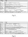
- Figures 5 and 6 each show a morphological analysis of technologies that can be used to constitute a device according to the second embodiment. Advantageous examples are indicated by bold type.
- Figure 7 shows parameter values for an exemplary embodiment of the scanner according to the invention.
Landscapes
- Physics & Mathematics (AREA)
- Engineering & Computer Science (AREA)
- General Physics & Mathematics (AREA)
- Computer Networks & Wireless Communication (AREA)
- Radar, Positioning & Navigation (AREA)
- Remote Sensing (AREA)
- Electromagnetism (AREA)
- Optics & Photonics (AREA)
- Optical Radar Systems And Details Thereof (AREA)
- Mechanical Optical Scanning Systems (AREA)
Applications Claiming Priority (1)
| Application Number | Priority Date | Filing Date | Title |
|---|---|---|---|
| EP16162714 | 2016-03-29 |
Publications (1)
| Publication Number | Publication Date |
|---|---|
| EP3226031A1 true EP3226031A1 (de) | 2017-10-04 |
Family
ID=55637306
Family Applications (1)
| Application Number | Title | Priority Date | Filing Date |
|---|---|---|---|
| EP17163391.0A Ceased EP3226031A1 (de) | 2016-03-29 | 2017-03-28 | Laserscanner |
Country Status (3)
| Country | Link |
|---|---|
| US (1) | US10634771B2 (de) |
| EP (1) | EP3226031A1 (de) |
| CN (1) | CN107238827B (de) |
Families Citing this family (6)
| Publication number | Priority date | Publication date | Assignee | Title |
|---|---|---|---|---|
| CN109213165B (zh) * | 2018-09-10 | 2021-08-06 | 成都英鑫光电科技有限公司 | 自动驾驶测距系统及自动驾驶系统 |
| CN111374592B (zh) * | 2018-12-27 | 2025-09-19 | 余姚舜宇智能光学技术有限公司 | 一种用于扫地机器人的tof模组和扫地机器人 |
| CN110703224A (zh) * | 2019-12-16 | 2020-01-17 | 杭州辰知光科技有限公司 | 一种面向无人驾驶的扫描型tof激光雷达 |
| JP7286573B2 (ja) * | 2020-03-12 | 2023-06-05 | 株式会社日立エルジーデータストレージ | 測距装置及び測距方法 |
| CN112099053A (zh) * | 2020-08-21 | 2020-12-18 | 上海禾赛光电科技有限公司 | 激光雷达的探测方法、激光雷达及包括其的车辆系统 |
| JP7424273B2 (ja) * | 2020-11-06 | 2024-01-30 | 株式会社デンソー | レーザレーダ装置 |
Citations (5)
| Publication number | Priority date | Publication date | Assignee | Title |
|---|---|---|---|---|
| US20030090647A1 (en) * | 2001-11-09 | 2003-05-15 | Emiko Isogai | Optical object detecting apparatus designed to selectively shift light emitting window |
| US20100106356A1 (en) * | 2008-10-24 | 2010-04-29 | The Gray Insurance Company | Control and systems for autonomously driven vehicles |
| EP2706377A1 (de) * | 2012-09-06 | 2014-03-12 | Fujitsu Limited | Objekterkennungsvorrichtung und Verfahren |
| US8836922B1 (en) * | 2013-08-20 | 2014-09-16 | Google Inc. | Devices and methods for a rotating LIDAR platform with a shared transmit/receive path |
| US20160071416A1 (en) * | 2014-09-05 | 2016-03-10 | Hyundai Mobis Co., Ltd. | System and method for detecting obstacles |
Family Cites Families (5)
| Publication number | Priority date | Publication date | Assignee | Title |
|---|---|---|---|---|
| JP2618912B2 (ja) * | 1987-08-31 | 1997-06-11 | 興和株式会社 | 眼底検査装置 |
| JP4428208B2 (ja) * | 2004-11-16 | 2010-03-10 | 株式会社デンソー | 車両用物体認識装置 |
| WO2008008970A2 (en) * | 2006-07-13 | 2008-01-17 | Velodyne Acoustics, Inc | High definition lidar system |
| GB2522142A (en) * | 2012-09-14 | 2015-07-15 | Faro Tech Inc | Laser scanner with dynamical adjustment of angular scan velocity |
| US9857472B2 (en) * | 2013-07-02 | 2018-01-02 | Electronics And Telecommunications Research Institute | Laser radar system for obtaining a 3D image |
-
2017
- 2017-03-28 CN CN201710192186.9A patent/CN107238827B/zh active Active
- 2017-03-28 EP EP17163391.0A patent/EP3226031A1/de not_active Ceased
- 2017-03-29 US US15/473,497 patent/US10634771B2/en active Active
Patent Citations (5)
| Publication number | Priority date | Publication date | Assignee | Title |
|---|---|---|---|---|
| US20030090647A1 (en) * | 2001-11-09 | 2003-05-15 | Emiko Isogai | Optical object detecting apparatus designed to selectively shift light emitting window |
| US20100106356A1 (en) * | 2008-10-24 | 2010-04-29 | The Gray Insurance Company | Control and systems for autonomously driven vehicles |
| EP2706377A1 (de) * | 2012-09-06 | 2014-03-12 | Fujitsu Limited | Objekterkennungsvorrichtung und Verfahren |
| US8836922B1 (en) * | 2013-08-20 | 2014-09-16 | Google Inc. | Devices and methods for a rotating LIDAR platform with a shared transmit/receive path |
| US20160071416A1 (en) * | 2014-09-05 | 2016-03-10 | Hyundai Mobis Co., Ltd. | System and method for detecting obstacles |
Non-Patent Citations (1)
| Title |
|---|
| VELODYNE: "User's Manual and Programming Guide HDL-64E S2 and S2.1", 10 September 2015 (2015-09-10), XP055401929, Retrieved from the Internet <URL:http://web.archive.org/web/20150910071407if_/http://velodynelidar.com/docs/manuals/63-HDL64ES2h HDL-64E S2 CD Users Manual.pdf> [retrieved on 20170829] * |
Also Published As
| Publication number | Publication date |
|---|---|
| US20170285147A1 (en) | 2017-10-05 |
| CN107238827A (zh) | 2017-10-10 |
| CN107238827B (zh) | 2021-04-27 |
| US10634771B2 (en) | 2020-04-28 |
Similar Documents
| Publication | Publication Date | Title |
|---|---|---|
| US10634771B2 (en) | Laser scanner | |
| JP7200378B2 (ja) | レンジ曖昧性を軽減するための複数の検出器を備えるライダー受光器 | |
| US12117553B2 (en) | LIDAR systems and methods for detection and classification of objects | |
| US12481037B2 (en) | Varying detection sensitivity between detections in LIDAR systems | |
| KR102898863B1 (ko) | Lidar 시스템 및 방법 | |
| JP7853947B2 (ja) | 可変解像度マルチビームスキャンを備えたlidarシステム | |
| US12123976B2 (en) | Laser scanner | |
| US20220187471A1 (en) | Lidar system with variable resolution multi-beam scanning | |
| KR102714940B1 (ko) | Lidar 시스템 및 방법 | |
| US10305247B2 (en) | Radiation source with a small-angle scanning array | |
| US10018724B2 (en) | System and method for scanning a surface and computer program implementing the method | |
| US11662463B2 (en) | Lidar apparatus and method | |
| US12553993B2 (en) | Flash LIDAR having nonuniform light modulation | |
| US10649071B2 (en) | Scanning optical system and radar | |
| US20240411146A1 (en) | Device for emitting a light beam and partial beam splitter | |
| WO2025037223A2 (en) | Device for emitting a light beam | |
| US20210373129A1 (en) | Acousto-optical beam deflecting unit for light detection and ranging (lidar) | |
| US20260072142A1 (en) | High utilization scanning LIDAR system | |
| US20260133297A1 (en) | Flash LIDAR having nonuniform light modulation | |
| dos Santos | Proof-of-concept of a single-point time-of-flight LiDAR system and guidelines towards integrated high-accuracy timing, advanced polarization sensing and scanning with a MEMS micromirror | |
| Zelinskyi | Scanning LiDAR for Telescope-based UAV Localization | |
| US11372109B1 (en) | Lidar with non-circular spatial filtering | |
| WO2024241321A1 (en) | Micro-optics on detection path of lidar systems |
Legal Events
| Date | Code | Title | Description |
|---|---|---|---|
| PUAI | Public reference made under article 153(3) epc to a published international application that has entered the european phase |
Free format text: ORIGINAL CODE: 0009012 |
|
| STAA | Information on the status of an ep patent application or granted ep patent |
Free format text: STATUS: THE APPLICATION HAS BEEN PUBLISHED |
|
| AK | Designated contracting states |
Kind code of ref document: A1 Designated state(s): AL AT BE BG CH CY CZ DE DK EE ES FI FR GB GR HR HU IE IS IT LI LT LU LV MC MK MT NL NO PL PT RO RS SE SI SK SM TR |
|
| AX | Request for extension of the european patent |
Extension state: BA ME |
|
| STAA | Information on the status of an ep patent application or granted ep patent |
Free format text: STATUS: REQUEST FOR EXAMINATION WAS MADE |
|
| 17P | Request for examination filed |
Effective date: 20180404 |
|
| RBV | Designated contracting states (corrected) |
Designated state(s): AL AT BE BG CH CY CZ DE DK EE ES FI FR GB GR HR HU IE IS IT LI LT LU LV MC MK MT NL NO PL PT RO RS SE SI SK SM TR |
|
| RIN1 | Information on inventor provided before grant (corrected) |
Inventor name: SCHEJA, JOCHEN Inventor name: MARK, SIMON Inventor name: HINDERLING, JUERG Inventor name: BOECKEM, BURKHARD Inventor name: HEINZLE, LUKAS Inventor name: SINGER, JULIEN |
|
| STAA | Information on the status of an ep patent application or granted ep patent |
Free format text: STATUS: EXAMINATION IS IN PROGRESS |
|
| 17Q | First examination report despatched |
Effective date: 20200526 |
|
| STAA | Information on the status of an ep patent application or granted ep patent |
Free format text: STATUS: THE APPLICATION HAS BEEN REFUSED |
|
| 18R | Application refused |
Effective date: 20211217 |