EP3260877B1 - Überwachung der integrität von radarhöhenmessern - Google Patents
Überwachung der integrität von radarhöhenmessern Download PDFInfo
- Publication number
- EP3260877B1 EP3260877B1 EP17170286.3A EP17170286A EP3260877B1 EP 3260877 B1 EP3260877 B1 EP 3260877B1 EP 17170286 A EP17170286 A EP 17170286A EP 3260877 B1 EP3260877 B1 EP 3260877B1
- Authority
- EP
- European Patent Office
- Prior art keywords
- gnss
- measurements
- altitude
- processor
- vehicle
- Prior art date
- Legal status (The legal status is an assumption and is not a legal conclusion. Google has not performed a legal analysis and makes no representation as to the accuracy of the status listed.)
- Active
Links
Images


Classifications
-
- G—PHYSICS
- G01—MEASURING; TESTING
- G01C—MEASURING DISTANCES, LEVELS OR BEARINGS; SURVEYING; NAVIGATION; GYROSCOPIC INSTRUMENTS; PHOTOGRAMMETRY OR VIDEOGRAMMETRY
- G01C25/00—Manufacturing, calibrating, cleaning, or repairing instruments or devices referred to in the other groups of this subclass
-
- G—PHYSICS
- G01—MEASURING; TESTING
- G01S—RADIO DIRECTION-FINDING; RADIO NAVIGATION; DETERMINING DISTANCE OR VELOCITY BY USE OF RADIO WAVES; LOCATING OR PRESENCE-DETECTING BY USE OF THE REFLECTION OR RERADIATION OF RADIO WAVES; ANALOGOUS ARRANGEMENTS USING OTHER WAVES
- G01S13/00—Systems using the reflection or reradiation of radio waves, e.g. radar systems; Analogous systems using reflection or reradiation of waves whose nature or wavelength is irrelevant or unspecified
- G01S13/88—Radar or analogous systems specially adapted for specific applications
- G01S13/882—Radar or analogous systems specially adapted for specific applications for altimeters
-
- G—PHYSICS
- G01—MEASURING; TESTING
- G01C—MEASURING DISTANCES, LEVELS OR BEARINGS; SURVEYING; NAVIGATION; GYROSCOPIC INSTRUMENTS; PHOTOGRAMMETRY OR VIDEOGRAMMETRY
- G01C21/00—Navigation; Navigational instruments not provided for in groups G01C1/00 - G01C19/00
- G01C21/10—Navigation; Navigational instruments not provided for in groups G01C1/00 - G01C19/00 by using measurements of speed or acceleration
- G01C21/12—Navigation; Navigational instruments not provided for in groups G01C1/00 - G01C19/00 by using measurements of speed or acceleration executed aboard the object being navigated; Dead reckoning
- G01C21/16—Navigation; Navigational instruments not provided for in groups G01C1/00 - G01C19/00 by using measurements of speed or acceleration executed aboard the object being navigated; Dead reckoning by integrating acceleration or speed, i.e. inertial navigation
- G01C21/165—Navigation; Navigational instruments not provided for in groups G01C1/00 - G01C19/00 by using measurements of speed or acceleration executed aboard the object being navigated; Dead reckoning by integrating acceleration or speed, i.e. inertial navigation combined with non-inertial navigation instruments
- G01C21/1652—Navigation; Navigational instruments not provided for in groups G01C1/00 - G01C19/00 by using measurements of speed or acceleration executed aboard the object being navigated; Dead reckoning by integrating acceleration or speed, i.e. inertial navigation combined with non-inertial navigation instruments with ranging devices, e.g. LIDAR or RADAR
-
- G—PHYSICS
- G01—MEASURING; TESTING
- G01C—MEASURING DISTANCES, LEVELS OR BEARINGS; SURVEYING; NAVIGATION; GYROSCOPIC INSTRUMENTS; PHOTOGRAMMETRY OR VIDEOGRAMMETRY
- G01C21/00—Navigation; Navigational instruments not provided for in groups G01C1/00 - G01C19/00
- G01C21/20—Instruments for performing navigational calculations
-
- G—PHYSICS
- G01—MEASURING; TESTING
- G01C—MEASURING DISTANCES, LEVELS OR BEARINGS; SURVEYING; NAVIGATION; GYROSCOPIC INSTRUMENTS; PHOTOGRAMMETRY OR VIDEOGRAMMETRY
- G01C21/00—Navigation; Navigational instruments not provided for in groups G01C1/00 - G01C19/00
- G01C21/26—Navigation; Navigational instruments not provided for in groups G01C1/00 - G01C19/00 specially adapted for navigation in a road network
- G01C21/28—Navigation; Navigational instruments not provided for in groups G01C1/00 - G01C19/00 specially adapted for navigation in a road network with correlation of data from several navigational instruments
- G01C21/30—Map- or contour-matching
-
- G—PHYSICS
- G01—MEASURING; TESTING
- G01S—RADIO DIRECTION-FINDING; RADIO NAVIGATION; DETERMINING DISTANCE OR VELOCITY BY USE OF RADIO WAVES; LOCATING OR PRESENCE-DETECTING BY USE OF THE REFLECTION OR RERADIATION OF RADIO WAVES; ANALOGOUS ARRANGEMENTS USING OTHER WAVES
- G01S13/00—Systems using the reflection or reradiation of radio waves, e.g. radar systems; Analogous systems using reflection or reradiation of waves whose nature or wavelength is irrelevant or unspecified
- G01S13/02—Systems using reflection of radio waves, e.g. primary radar systems; Analogous systems
- G01S13/06—Systems determining position data of a target
- G01S13/08—Systems for measuring distance only
-
- G—PHYSICS
- G01—MEASURING; TESTING
- G01S—RADIO DIRECTION-FINDING; RADIO NAVIGATION; DETERMINING DISTANCE OR VELOCITY BY USE OF RADIO WAVES; LOCATING OR PRESENCE-DETECTING BY USE OF THE REFLECTION OR RERADIATION OF RADIO WAVES; ANALOGOUS ARRANGEMENTS USING OTHER WAVES
- G01S13/00—Systems using the reflection or reradiation of radio waves, e.g. radar systems; Analogous systems using reflection or reradiation of waves whose nature or wavelength is irrelevant or unspecified
- G01S13/86—Combinations of radar systems with non-radar systems, e.g. sonar, direction finder
-
- G—PHYSICS
- G01—MEASURING; TESTING
- G01S—RADIO DIRECTION-FINDING; RADIO NAVIGATION; DETERMINING DISTANCE OR VELOCITY BY USE OF RADIO WAVES; LOCATING OR PRESENCE-DETECTING BY USE OF THE REFLECTION OR RERADIATION OF RADIO WAVES; ANALOGOUS ARRANGEMENTS USING OTHER WAVES
- G01S19/00—Satellite radio beacon positioning systems; Determining position, velocity or attitude using signals transmitted by such systems
- G01S19/01—Satellite radio beacon positioning systems transmitting time-stamped messages, e.g. GPS [Global Positioning System], GLONASS [Global Orbiting Navigation Satellite System] or GALILEO
- G01S19/13—Receivers
- G01S19/20—Integrity monitoring, fault detection or fault isolation of space segment
-
- G—PHYSICS
- G01—MEASURING; TESTING
- G01S—RADIO DIRECTION-FINDING; RADIO NAVIGATION; DETERMINING DISTANCE OR VELOCITY BY USE OF RADIO WAVES; LOCATING OR PRESENCE-DETECTING BY USE OF THE REFLECTION OR RERADIATION OF RADIO WAVES; ANALOGOUS ARRANGEMENTS USING OTHER WAVES
- G01S19/00—Satellite radio beacon positioning systems; Determining position, velocity or attitude using signals transmitted by such systems
- G01S19/38—Determining a navigation solution using signals transmitted by a satellite radio beacon positioning system
- G01S19/39—Determining a navigation solution using signals transmitted by a satellite radio beacon positioning system the satellite radio beacon positioning system transmitting time-stamped messages, e.g. GPS [Global Positioning System], GLONASS [Global Orbiting Navigation Satellite System] or GALILEO
- G01S19/42—Determining position
- G01S19/45—Determining position by combining measurements of signals from the satellite radio beacon positioning system with a supplementary measurement
- G01S19/47—Determining position by combining measurements of signals from the satellite radio beacon positioning system with a supplementary measurement the supplementary measurement being an inertial measurement, e.g. tightly coupled inertial
-
- G—PHYSICS
- G01—MEASURING; TESTING
- G01S—RADIO DIRECTION-FINDING; RADIO NAVIGATION; DETERMINING DISTANCE OR VELOCITY BY USE OF RADIO WAVES; LOCATING OR PRESENCE-DETECTING BY USE OF THE REFLECTION OR RERADIATION OF RADIO WAVES; ANALOGOUS ARRANGEMENTS USING OTHER WAVES
- G01S7/00—Details of systems according to groups G01S13/00, G01S15/00, G01S17/00
- G01S7/02—Details of systems according to groups G01S13/00, G01S15/00, G01S17/00 of systems according to group G01S13/00
- G01S7/40—Means for monitoring or calibrating
Definitions
- a radar altimeter is an aircraft sensor that measures altitude above terrain by transmitting a radio signal and receiving a reflection of the signal from a terrain surface.
- the radar altimeter measured altitude is an important piece of information used by a pilot and onboard systems (e.g., an autopilot system) during the various phases of flight, including approach and landing.
- an aircraft is usually equipped with several radar altimeters.
- the measurements from all radar altimeters are processed (e.g., compared to each other) and the resulting value of the altitude is provided to onboard systems and the pilot.
- the altitude is provided without any information related to its accuracy or integrity, which limits utilization of radar altimeter measurements in envisioned applications related to more autonomous aircraft.
- NAVSTAR GPS User Equipment Instruction to the US Coast Guard, 01 September 1996, pp2-3 , discloses integrity monitoring receivers to derive multiple position solutions by excluding one satellite at a time, where inconsistencies in the results are used to identify and exclude a faulty satellite.
- GPS III-Galileo/Altimeter Landing System for CAT IIIB: Concept and Analysis to Braff et al in Navigation: Journal of the Institute of Navigation (2009), Vol.55, No.4, pp.267-281 discloses using radar altimeters for determining altitude in aircrafts, and the integration of their results in GPS integrity.
- GNSS Global Navigation Satellite System
- GNSS/INS hybridized Global Navigation Satellite System and Inertial Navigation System
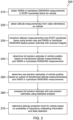
- One method comprises obtaining one or more global navigation satellite system (GNSS) measurements, or one or more hybridized GNSS/inertial navigation system (INS) measurements, in an earth-centered-earth-fixed (ECEF) coordinate frame for a vehicle; obtaining one or more altitude measurements from one or more radar altimeters on the vehicle; transforming the one or more altitude measurements into the ECEF coordinate frame using a terrain map and a GNSS or hybridized GNSS/INS based position estimate with ensured integrity as defined in the appended claim 1; determining a full solution estimate of position for the vehicle based on the transformed one or more altitude measurements, and the one or more GNSS or hybridized GNSS/INS measurements; determining one or more sub-solution estimates of position for the vehicle based on a subset of the transformed one or more altitude measurements, and the one or more GNSS or hybridized GNSS/INS measurements; comparing the full solution estimate with the
Landscapes
- Engineering & Computer Science (AREA)
- Radar, Positioning & Navigation (AREA)
- Remote Sensing (AREA)
- Physics & Mathematics (AREA)
- General Physics & Mathematics (AREA)
- Computer Networks & Wireless Communication (AREA)
- Automation & Control Theory (AREA)
- Electromagnetism (AREA)
- Computer Security & Cryptography (AREA)
- Manufacturing & Machinery (AREA)
- Navigation (AREA)
- Radar Systems Or Details Thereof (AREA)
- Position Fixing By Use Of Radio Waves (AREA)
- Traffic Control Systems (AREA)
Claims (6)
- Verfahren (200) zur Radaraltimeter-Integritätsüberwachung, das Verfahren umfassend:Erhalten einer oder mehrerer Messungen von einem globalen Navigationssatellitensystem, GNSS, oder einer oder mehrerer hybridisierter Messungen von einem GNSS/inertialem Navigationssystem, INS, in einem erdzentrierten-erdfesten, ECEF, Koordinatensystem für ein Fahrzeug (210);Erhalten einer oder mehrerer Höhenmessungen von einem oder mehreren Radaraltimetern an dem Fahrzeug (220);
Umwandeln der einen oder der mehreren Höhenmessungen in das ECEF-Koordinatensystem unter Verwendung einer Geländekarte und einer GNSS-basierten oder hybridisierten GNSS/INS-basierten Positionsschätzung mit sichergestellter Integrität (230), wobei die umgewandelte eine oder die umgewandelten mehreren Höhenmessungen durch die folgende Gleichung angegeben werden: Berechnen einer oder mehrerer Eigenschaften der umgewandelten einen oder mehreren Höhenmessungen, die orthogonale Abstandsmomente PTERMAP beinhalten, wobei ein Mittelwert des orthogonalen Abstands PTERMAP berechnet wird als:
 Bestimmen einer Gesamtlösungsschätzung einer Position für das Fahrzeug auf Basis der umgewandelten einen oder mehreren Höhenmessungen, und der einen oder mehreren GNSS- oder hybridisierten GNSS/INS-Messungen (240);Bestimmen einer oder mehrerer Teillösungsschätzungen einer Position für das Fahrzeug auf Basis eines Teilsatzes der umgewandelten einen oder mehreren Höhenmessungen, und der einen oder mehreren GNSS- oder hybridisierten GNSS/INS-Messungen (250);Vergleichen der Gesamtlösungsschätzung mit der einen oder den mehreren Teillösungsschätzungen unter Verwendung von statistischer Analyse (260); undBestimmen eines Höhenschutzniveaus für das Fahrzeug auf Basis einer Wahrscheinlichkeit von gefährlichen irreführenden Informationen und einer Wahrscheinlichkeit einer falschen Erkennung (270).
 - Navigationssystem (100), umfassend:einen Prozessor (112) in einem Fahrzeug;eine Speichereinheit (114), die betriebsfähig mit dem Prozessor (112) gekoppelt ist, wobei eine Geländekarte (120) in der Speichereinheit (114) gespeichert ist;einen Empfänger (116) eines globalen Navigationssatellitensystems, GNSS, der betriebsfähig mit dem Prozessor (112) gekoppelt ist; undeinen oder mehrere Radaraltimeter (118), die betriebsfähig mit dem Prozessor (112) gekoppelt sind;wobei der Prozessor (112) dazu konfiguriert ist, prozessorlesbare Anweisungen auszuführen, um das Verfahren zur Radaraltimeter-Integritätsüberwachung nach Anspruch 1 durchzuführen.
- Navigationssystem (100) nach Anspruch 2, ferner umfassend eine Vielzahl von inertialen Sensoren (124), die betriebsfähig mit dem Prozessor (112) gekoppelt und dazu konfiguriert sind, inertiale Daten an den Prozessor (112) bereitzustellen.
- Navigationssystem (100) nach Anspruch 2, ferner umfassend ein barometrisches Altimeter (122), das betriebsfähig mit dem Prozessor (112) gekoppelt ist.
- Navigationssystem nach Anspruch 3, wobei die inertialen Sensoren in einer inertialen Messeinheit, IMU, implementiert sind.
- Computerprogrammprodukt, umfassend:
ein computerlesbares Medium, das darauf gespeicherte Anweisungen aufweist, die von einem Prozessor (112) dazu ausführbar sind, das Verfahren zur Radaraltimeter-Integritätsüberwachung nach Anspruch 1 durchzuführen.
Applications Claiming Priority (1)
| Application Number | Priority Date | Filing Date | Title |
|---|---|---|---|
| US15/170,322 US10422872B2 (en) | 2016-06-01 | 2016-06-01 | Integrity monitoring of radar altimeters |
Publications (3)
| Publication Number | Publication Date |
|---|---|
| EP3260877A2 EP3260877A2 (de) | 2017-12-27 |
| EP3260877A3 EP3260877A3 (de) | 2018-03-21 |
| EP3260877B1 true EP3260877B1 (de) | 2025-07-02 |
Family
ID=58699041
Family Applications (1)
| Application Number | Title | Priority Date | Filing Date |
|---|---|---|---|
| EP17170286.3A Active EP3260877B1 (de) | 2016-06-01 | 2017-05-09 | Überwachung der integrität von radarhöhenmessern |
Country Status (3)
| Country | Link |
|---|---|
| US (1) | US10422872B2 (de) |
| EP (1) | EP3260877B1 (de) |
| CN (1) | CN107449443B (de) |
Families Citing this family (26)
| Publication number | Priority date | Publication date | Assignee | Title |
|---|---|---|---|---|
| JP6021189B2 (ja) | 2011-02-21 | 2016-11-09 | トランスロボティックス,インク. | 距離および/または移動を感知するためのシステムおよび方法 |
| US10206610B2 (en) | 2012-10-05 | 2019-02-19 | TransRobotics, Inc. | Systems and methods for high resolution distance sensing and applications |
| US10417918B2 (en) * | 2016-01-20 | 2019-09-17 | Honeywell International Inc. | Methods and systems to assist in a search and rescue mission |
| US10422872B2 (en) | 2016-06-01 | 2019-09-24 | Honeywell International Inc. | Integrity monitoring of radar altimeters |
| US10760911B2 (en) * | 2017-03-29 | 2020-09-01 | Honeywell International Inc. | Integrity monitoring method for navigation systems with heterogeneous measurements |
| CN109212495B (zh) * | 2018-08-06 | 2023-03-03 | 中国航空工业集团公司雷华电子技术研究所 | 一种基于陀螺仪的雷达自动校靶方法及系统 |
| US11035962B2 (en) * | 2018-09-11 | 2021-06-15 | Honeywell International S.R.O. | Supplemental system for a satellite based approach during low visibility conditions |
| US20200132832A1 (en) * | 2018-10-25 | 2020-04-30 | TransRobotics, Inc. | Technologies for opportunistic synthetic aperture radar |
| DE102018222663A1 (de) * | 2018-12-20 | 2020-06-25 | Robert Bosch Gmbh | Verfahren zum adaptiven Ermitteln eines Integritätsbereichs einer Parameterschätzung |
| US11168986B2 (en) * | 2019-02-13 | 2021-11-09 | Rockwell Collins, Inc. | Navigation system and method |
| EP3719532B1 (de) | 2019-04-04 | 2022-12-28 | Transrobotics, Inc. | Technologien zum handeln auf basis von objektverfolgung |
| US11321563B2 (en) * | 2019-08-28 | 2022-05-03 | Honeywell Aerospace Sas | Handling of ARAIM terrain database induced errors |
| US11414215B2 (en) * | 2019-09-20 | 2022-08-16 | Honeywell International Inc. | Methods, apparatuses and systems for predicting radio altimeter failure |
| US11482122B2 (en) | 2020-02-04 | 2022-10-25 | Honeywell International Inc. | Methods and systems for monitoring a fault condition of a radar altitude device |
| FR3107964B1 (fr) * | 2020-03-04 | 2022-02-11 | Renault Sas | Procédé de détection de cibles par un radar |
| US11662472B2 (en) * | 2020-04-20 | 2023-05-30 | Honeywell International Inc. | Integrity monitoring of odometry measurements within a navigation system |
| EP3901650A1 (de) * | 2020-04-20 | 2021-10-27 | Honeywell International Inc. | Integritätsüberwachung von odometrischen messungen innerhalb eines navigationssystems |
| EP4155777B1 (de) * | 2020-07-15 | 2025-05-28 | The Boeing Company | Verfahren zur verwaltung eines fehlerzustands in einem positions-, navigations- und timing-system für einen benutzer |
| US12153147B2 (en) | 2021-05-17 | 2024-11-26 | Reliable Robotics Corporation | Filter augmented receiver autonomous integrity monitoring in aircraft |
| US11835341B2 (en) * | 2021-07-20 | 2023-12-05 | Honeywell International Inc. | Integrity monitoring of vehicle kinematic states using map-based, vision navigation systems |
| US12078738B2 (en) * | 2021-11-09 | 2024-09-03 | Msrs Llc | Method, apparatus, and computer readable medium for a multi-source reckoning system |
| CN114235007B (zh) * | 2021-12-02 | 2023-09-29 | 北京航空航天大学 | 一种apnt服务的定位和完好性监测方法及系统 |
| US12174306B2 (en) * | 2022-07-26 | 2024-12-24 | Honeywell International S.R.O. | Method and system to process and assure integrity of DME and/or VOR measurements and mitigate GNSS jamming and spoofing events |
| US12241985B2 (en) * | 2022-07-26 | 2025-03-04 | Honeywell International S.R.O. | Method and system to process and assure integrity of radar measurements and mitigate GNSS jamming and spoofing events |
| CN117191049A (zh) * | 2023-08-10 | 2023-12-08 | 北京航空航天大学 | 一种航空导航网络机载定位方法及系统 |
| CN117395085B (zh) * | 2023-12-12 | 2024-03-22 | 天津医康互联科技有限公司 | 全局协方差矩阵计算方法、装置、电子设备及存储介质 |
Family Cites Families (19)
| Publication number | Priority date | Publication date | Assignee | Title |
|---|---|---|---|---|
| US5760737A (en) | 1996-09-11 | 1998-06-02 | Honeywell Inc. | Navigation system with solution separation apparatus for detecting accuracy failures |
| US6281832B1 (en) * | 1999-08-31 | 2001-08-28 | Rockwell Collins | Method and apparatus for using statistical data processing in altimeter and terrain awareness integrity monitoring systems |
| CN1361409A (zh) * | 2000-12-23 | 2002-07-31 | 林清芳 | 增强型导航定位之方法及其系统 |
| AP1773A (en) * | 2001-10-11 | 2007-08-27 | Bhp Billiton Innovation Pty Ltd | Airborne geophysical measurements. |
| US6639549B2 (en) * | 2001-12-20 | 2003-10-28 | Honeywell International Inc. | Fault detection and exclusion for global position systems |
| US7145501B1 (en) * | 2005-09-26 | 2006-12-05 | Honeywell International Inc. | Methods and systems for measuring terrain height |
| FR2906893B1 (fr) * | 2006-10-06 | 2009-01-16 | Thales Sa | Procede et dispositif de surveillance de l'integrite des informations delivrees par un systeme hybride ins/gnss |
| FR2928741B1 (fr) * | 2008-03-11 | 2020-06-26 | Thales | Dispositif et procede de surveillance d'integrite en temps reel d'un systeme de navigation par satellite |
| CN101319902B (zh) | 2008-07-18 | 2010-09-08 | 哈尔滨工程大学 | 一种低成本组合式定位定向装置及组合定位方法 |
| US8296056B2 (en) * | 2009-04-20 | 2012-10-23 | Honeywell International Inc. | Enhanced vision system for precision navigation in low visibility or global positioning system (GPS) denied conditions |
| US20110181465A1 (en) * | 2010-01-26 | 2011-07-28 | Rongsheng Li | Multi-constellation global navigation satellite system augmentation and assistance |
| US9182495B2 (en) * | 2011-09-21 | 2015-11-10 | Lockheed Martin Corporation | System and method for monitoring integrity of a global navigation satellite system |
| US8498758B1 (en) * | 2012-08-03 | 2013-07-30 | Rockwell Collins, Inc. | ILS-based altitude data generation system, device, and method |
| US9547086B2 (en) | 2013-03-26 | 2017-01-17 | Honeywell International Inc. | Selected aspects of advanced receiver autonomous integrity monitoring application to kalman filter based navigation filter |
| FR3004826B1 (fr) * | 2013-04-18 | 2015-05-08 | Sagem Defense Securite | Procede de controle d'integrite et dispositif de fusion-consolidation comprenant un pluralite de modules de traitement |
| US9784844B2 (en) | 2013-11-27 | 2017-10-10 | Honeywell International Inc. | Architectures for high integrity multi-constellation solution separation |
| US9542782B2 (en) * | 2014-08-25 | 2017-01-10 | Justin James Blank, SR. | Aircraft landing and takeoff logging system |
| EP3120166B1 (de) * | 2015-01-14 | 2018-04-18 | STM Savunma Teknolojileri Mühendislik Ve Ticaret Anonim Sirketi | Präzises positionierungsverfahren |
| US10422872B2 (en) | 2016-06-01 | 2019-09-24 | Honeywell International Inc. | Integrity monitoring of radar altimeters |
-
2016
- 2016-06-01 US US15/170,322 patent/US10422872B2/en active Active
-
2017
- 2017-05-09 EP EP17170286.3A patent/EP3260877B1/de active Active
- 2017-05-31 CN CN201710397776.5A patent/CN107449443B/zh active Active
Non-Patent Citations (2)
| Title |
|---|
| LEE ET AL: "Analysis of range and position comparison methods as a means to provide GPS integrity in the user receiver", PROCEEDINGS OF THE INSTITUTE OF NAVIGATION ANNUAL MEETING, XX, XX, no. 42nd, 24 June 1986 (1986-06-24), pages 17pp, XP007902751 * |
| SHIVELY CURTIS A ET AL: "Error and Availability Analysis of Category IIIb LAAS Augmented by Radar Altimeter", NAVIGATION: JOURNAL OF THE INSTITUTE OF NAVIGATION, INSTITUTE OF NAVIGATION, FAIRFAX, VA, US, vol. 52, no. 3, 1 December 2005 (2005-12-01), pages 155 - 162, XP056013463, ISSN: 0028-1522 * |
Also Published As
| Publication number | Publication date |
|---|---|
| US20170350973A1 (en) | 2017-12-07 |
| US10422872B2 (en) | 2019-09-24 |
| CN107449443A (zh) | 2017-12-08 |
| EP3260877A3 (de) | 2018-03-21 |
| EP3260877A2 (de) | 2017-12-27 |
| CN107449443B (zh) | 2023-06-27 |
Similar Documents
| Publication | Publication Date | Title |
|---|---|---|
| EP3260877B1 (de) | Überwachung der integrität von radarhöhenmessern | |
| EP3730971B1 (de) | Reduzierung der vorspannungsauswirkung auf die gnss-integrität | |
| EP2784445B1 (de) | Ausgewählte Aspekte einer erweiterten Anwendung zur autonomen Empfängerintegritätsüberwachung eines Navigationsfilters auf Kalman-Filter-Basis | |
| EP4024087B1 (de) | Gnss-signal-spoofing-erkennung über beobachtung von peilungs- und/oder entfernungssensoren | |
| US10408942B2 (en) | Systems and methods to detect GPS spoofing | |
| US10996345B2 (en) | Signal fault detection for global navigation satellite system using multiple antennas | |
| US11662472B2 (en) | Integrity monitoring of odometry measurements within a navigation system | |
| EP4024088B1 (de) | Geländedatenbankgestützte gnss-spoofing-bestimmung | |
| EP3373041B1 (de) | Fehlalarmverteilung in autonomer empfängerseitiger integritätsüberwachung | |
| EP2706379A1 (de) | Verfahren und System zur Bereitstellung der Integrität für die hybride Stellung und wahre Richtungsgabe | |
| US11536854B2 (en) | Multiple faulty global navigation satellite system signal detecting system | |
| EP3786671B1 (de) | Behandlung von durch araim-terrain-datenbank induzierten fehlern | |
| EP3722834B1 (de) | Integritätsüberwachung von primären und abgeleiteten parametern | |
| US12241985B2 (en) | Method and system to process and assure integrity of radar measurements and mitigate GNSS jamming and spoofing events | |
| US20150073707A1 (en) | Systems and methods for comparing range data with evidence grids | |
| EP3901650A1 (de) | Integritätsüberwachung von odometrischen messungen innerhalb eines navigationssystems | |
| EP3757518B1 (de) | Verfahren zur gewährleistung der integrität von integrierten zertifizierten und nichtzertifizierten sensoren | |
| EP3623846B1 (de) | Zusatzsystem für einen satellitengestützten ansatz bei schlechten sichtverhältnissen | |
| EP4418018A1 (de) | System und verfahren zur gnss-spoofer-detektion mit hoher integritätsfehlerbegrenzung unter verwendung mehrerer segellösungen |
Legal Events
| Date | Code | Title | Description |
|---|---|---|---|
| PUAI | Public reference made under article 153(3) epc to a published international application that has entered the european phase |
Free format text: ORIGINAL CODE: 0009012 |
|
| STAA | Information on the status of an ep patent application or granted ep patent |
Free format text: STATUS: REQUEST FOR EXAMINATION WAS MADE |
|
| 17P | Request for examination filed |
Effective date: 20170509 |
|
| AK | Designated contracting states |
Kind code of ref document: A2 Designated state(s): AL AT BE BG CH CY CZ DE DK EE ES FI FR GB GR HR HU IE IS IT LI LT LU LV MC MK MT NL NO PL PT RO RS SE SI SK SM TR |
|
| AX | Request for extension of the european patent |
Extension state: BA ME |
|
| PUAL | Search report despatched |
Free format text: ORIGINAL CODE: 0009013 |
|
| AK | Designated contracting states |
Kind code of ref document: A3 Designated state(s): AL AT BE BG CH CY CZ DE DK EE ES FI FR GB GR HR HU IE IS IT LI LT LU LV MC MK MT NL NO PL PT RO RS SE SI SK SM TR |
|
| AX | Request for extension of the european patent |
Extension state: BA ME |
|
| RIC1 | Information provided on ipc code assigned before grant |
Ipc: G01S 7/40 20060101AFI20180210BHEP Ipc: G01S 19/20 20100101ALI20180210BHEP Ipc: G01S 13/86 20060101ALI20180210BHEP |
|
| STAA | Information on the status of an ep patent application or granted ep patent |
Free format text: STATUS: EXAMINATION IS IN PROGRESS |
|
| 17Q | First examination report despatched |
Effective date: 20210419 |
|
| P01 | Opt-out of the competence of the unified patent court (upc) registered |
Effective date: 20230421 |
|
| GRAP | Despatch of communication of intention to grant a patent |
Free format text: ORIGINAL CODE: EPIDOSNIGR1 |
|
| STAA | Information on the status of an ep patent application or granted ep patent |
Free format text: STATUS: GRANT OF PATENT IS INTENDED |
|
| INTG | Intention to grant announced |
Effective date: 20250116 |
|
| GRAS | Grant fee paid |
Free format text: ORIGINAL CODE: EPIDOSNIGR3 |
|
| GRAA | (expected) grant |
Free format text: ORIGINAL CODE: 0009210 |
|
| STAA | Information on the status of an ep patent application or granted ep patent |
Free format text: STATUS: THE PATENT HAS BEEN GRANTED |
|
| AK | Designated contracting states |
Kind code of ref document: B1 Designated state(s): AL AT BE BG CH CY CZ DE DK EE ES FI FR GB GR HR HU IE IS IT LI LT LU LV MC MK MT NL NO PL PT RO RS SE SI SK SM TR |
|
| REG | Reference to a national code |
Ref country code: GB Ref legal event code: FG4D |
|
| REG | Reference to a national code |
Ref country code: CH Ref legal event code: EP |
|
| REG | Reference to a national code |
Ref country code: DE Ref legal event code: R096 Ref document number: 602017090234 Country of ref document: DE |
|
| REG | Reference to a national code |
Ref country code: IE Ref legal event code: FG4D |
|
| REG | Reference to a national code |
Ref country code: NL Ref legal event code: FP |
|
| PG25 | Lapsed in a contracting state [announced via postgrant information from national office to epo] |
Ref country code: PT Free format text: LAPSE BECAUSE OF FAILURE TO SUBMIT A TRANSLATION OF THE DESCRIPTION OR TO PAY THE FEE WITHIN THE PRESCRIBED TIME-LIMIT Effective date: 20251103 |
|
| REG | Reference to a national code |
Ref country code: AT Ref legal event code: MK05 Ref document number: 1809822 Country of ref document: AT Kind code of ref document: T Effective date: 20250702 |
|
| PG25 | Lapsed in a contracting state [announced via postgrant information from national office to epo] |
Ref country code: IS Free format text: LAPSE BECAUSE OF FAILURE TO SUBMIT A TRANSLATION OF THE DESCRIPTION OR TO PAY THE FEE WITHIN THE PRESCRIBED TIME-LIMIT Effective date: 20251102 |
|
| PG25 | Lapsed in a contracting state [announced via postgrant information from national office to epo] |
Ref country code: NO Free format text: LAPSE BECAUSE OF FAILURE TO SUBMIT A TRANSLATION OF THE DESCRIPTION OR TO PAY THE FEE WITHIN THE PRESCRIBED TIME-LIMIT Effective date: 20251002 |
|
| REG | Reference to a national code |
Ref country code: LT Ref legal event code: MG9D |
|
| PG25 | Lapsed in a contracting state [announced via postgrant information from national office to epo] |
Ref country code: AT Free format text: LAPSE BECAUSE OF FAILURE TO SUBMIT A TRANSLATION OF THE DESCRIPTION OR TO PAY THE FEE WITHIN THE PRESCRIBED TIME-LIMIT Effective date: 20250702 |
|
| PG25 | Lapsed in a contracting state [announced via postgrant information from national office to epo] |
Ref country code: FI Free format text: LAPSE BECAUSE OF FAILURE TO SUBMIT A TRANSLATION OF THE DESCRIPTION OR TO PAY THE FEE WITHIN THE PRESCRIBED TIME-LIMIT Effective date: 20250702 |
|
| PG25 | Lapsed in a contracting state [announced via postgrant information from national office to epo] |
Ref country code: HR Free format text: LAPSE BECAUSE OF FAILURE TO SUBMIT A TRANSLATION OF THE DESCRIPTION OR TO PAY THE FEE WITHIN THE PRESCRIBED TIME-LIMIT Effective date: 20250702 |
|
| PG25 | Lapsed in a contracting state [announced via postgrant information from national office to epo] |
Ref country code: GR Free format text: LAPSE BECAUSE OF FAILURE TO SUBMIT A TRANSLATION OF THE DESCRIPTION OR TO PAY THE FEE WITHIN THE PRESCRIBED TIME-LIMIT Effective date: 20251003 |
|
| PG25 | Lapsed in a contracting state [announced via postgrant information from national office to epo] |
Ref country code: CZ Free format text: LAPSE BECAUSE OF FAILURE TO SUBMIT A TRANSLATION OF THE DESCRIPTION OR TO PAY THE FEE WITHIN THE PRESCRIBED TIME-LIMIT Effective date: 20250702 Ref country code: SE Free format text: LAPSE BECAUSE OF FAILURE TO SUBMIT A TRANSLATION OF THE DESCRIPTION OR TO PAY THE FEE WITHIN THE PRESCRIBED TIME-LIMIT Effective date: 20250702 |
|
| PG25 | Lapsed in a contracting state [announced via postgrant information from national office to epo] |
Ref country code: LV Free format text: LAPSE BECAUSE OF FAILURE TO SUBMIT A TRANSLATION OF THE DESCRIPTION OR TO PAY THE FEE WITHIN THE PRESCRIBED TIME-LIMIT Effective date: 20250702 |
|
| PG25 | Lapsed in a contracting state [announced via postgrant information from national office to epo] |
Ref country code: BG Free format text: LAPSE BECAUSE OF FAILURE TO SUBMIT A TRANSLATION OF THE DESCRIPTION OR TO PAY THE FEE WITHIN THE PRESCRIBED TIME-LIMIT Effective date: 20250702 Ref country code: PL Free format text: LAPSE BECAUSE OF FAILURE TO SUBMIT A TRANSLATION OF THE DESCRIPTION OR TO PAY THE FEE WITHIN THE PRESCRIBED TIME-LIMIT Effective date: 20250702 |
|
| PG25 | Lapsed in a contracting state [announced via postgrant information from national office to epo] |
Ref country code: RS Free format text: LAPSE BECAUSE OF FAILURE TO SUBMIT A TRANSLATION OF THE DESCRIPTION OR TO PAY THE FEE WITHIN THE PRESCRIBED TIME-LIMIT Effective date: 20251002 |
|
| PG25 | Lapsed in a contracting state [announced via postgrant information from national office to epo] |
Ref country code: ES Free format text: LAPSE BECAUSE OF FAILURE TO SUBMIT A TRANSLATION OF THE DESCRIPTION OR TO PAY THE FEE WITHIN THE PRESCRIBED TIME-LIMIT Effective date: 20250702 |
|
| PG25 | Lapsed in a contracting state [announced via postgrant information from national office to epo] |
Ref country code: SM Free format text: LAPSE BECAUSE OF FAILURE TO SUBMIT A TRANSLATION OF THE DESCRIPTION OR TO PAY THE FEE WITHIN THE PRESCRIBED TIME-LIMIT Effective date: 20250702 |
|
| PG25 | Lapsed in a contracting state [announced via postgrant information from national office to epo] |
Ref country code: DK Free format text: LAPSE BECAUSE OF FAILURE TO SUBMIT A TRANSLATION OF THE DESCRIPTION OR TO PAY THE FEE WITHIN THE PRESCRIBED TIME-LIMIT Effective date: 20250702 |
|
| PG25 | Lapsed in a contracting state [announced via postgrant information from national office to epo] |
Ref country code: IT Free format text: LAPSE BECAUSE OF FAILURE TO SUBMIT A TRANSLATION OF THE DESCRIPTION OR TO PAY THE FEE WITHIN THE PRESCRIBED TIME-LIMIT Effective date: 20250702 |
|
| PG25 | Lapsed in a contracting state [announced via postgrant information from national office to epo] |
Ref country code: SK Free format text: LAPSE BECAUSE OF FAILURE TO SUBMIT A TRANSLATION OF THE DESCRIPTION OR TO PAY THE FEE WITHIN THE PRESCRIBED TIME-LIMIT Effective date: 20250702 Ref country code: EE Free format text: LAPSE BECAUSE OF FAILURE TO SUBMIT A TRANSLATION OF THE DESCRIPTION OR TO PAY THE FEE WITHIN THE PRESCRIBED TIME-LIMIT Effective date: 20250702 |