EP3290865A2 - Procédé de métré de plans d'eau provenant de données osm - Google Patents
Procédé de métré de plans d'eau provenant de données osm Download PDFInfo
- Publication number
- EP3290865A2 EP3290865A2 EP17179759.0A EP17179759A EP3290865A2 EP 3290865 A2 EP3290865 A2 EP 3290865A2 EP 17179759 A EP17179759 A EP 17179759A EP 3290865 A2 EP3290865 A2 EP 3290865A2
- Authority
- EP
- European Patent Office
- Prior art keywords
- coastline
- read
- area
- edge
- data
- Prior art date
- Legal status (The legal status is an assumption and is not a legal conclusion. Google has not performed a legal analysis and makes no representation as to the accuracy of the status listed.)
- Withdrawn
Links
- XLYOFNOQVPJJNP-UHFFFAOYSA-N water Substances O XLYOFNOQVPJJNP-UHFFFAOYSA-N 0.000 title claims abstract description 45
- 238000000034 method Methods 0.000 title claims abstract description 43
- 238000004590 computer program Methods 0.000 claims abstract description 3
- 239000003643 water by type Substances 0.000 description 6
- 238000011156 evaluation Methods 0.000 description 5
- 101150064138 MAP1 gene Proteins 0.000 description 4
- 230000007704 transition Effects 0.000 description 4
- 238000011161 development Methods 0.000 description 3
- 230000018109 developmental process Effects 0.000 description 3
- 238000007781 pre-processing Methods 0.000 description 3
- 239000013598 vector Substances 0.000 description 3
- 238000012545 processing Methods 0.000 description 2
- 238000000638 solvent extraction Methods 0.000 description 2
- 230000001419 dependent effect Effects 0.000 description 1
- 238000013461 design Methods 0.000 description 1
Images
Classifications
-
- G—PHYSICS
- G01—MEASURING; TESTING
- G01C—MEASURING DISTANCES, LEVELS OR BEARINGS; SURVEYING; NAVIGATION; GYROSCOPIC INSTRUMENTS; PHOTOGRAMMETRY OR VIDEOGRAMMETRY
- G01C21/00—Navigation; Navigational instruments not provided for in groups G01C1/00 - G01C19/00
- G01C21/38—Electronic maps specially adapted for navigation; Updating thereof
- G01C21/3804—Creation or updating of map data
- G01C21/3807—Creation or updating of map data characterised by the type of data
- G01C21/3826—Terrain data
Definitions
- Non-commercial data sources are also available, one of the best-known examples is OpenStreetMap (OSM).
- OSM OpenStreetMap
- the freely available OSM data also contains many of the information necessary for navigation and display purposes.
- no water bodies are included in the OSM data.
- the illustration of a map of Europe without water surfaces, for the most part, does not meet the expectations of consumers.
- a disadvantage of this method is the need to obtain additional data by remote sensing.
- OSM data As raw data for navigation systems, licensing fees can be saved, and navigation products can be offered cheaper. However, this implies the need to include the water areas in the navigation data in order to meet emerging customer expectations for complete presentation in navigation systems based on OSM data.
- the object of the invention is the development of a method for determining water areas from the information available in the OSM data.
- desired water areas for navigation data should be determined from the information contained in OSM data.
- the method for determining the water areas and thus the shorelines should be as simple as possible and without additional costs such. Remote sensing can be performed.
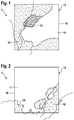
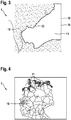
- FIG. 4 Figure 11 is a view of the map 1 with water areas 11 shown north over the land areas 10, hatched in the finished navigation data on the coast. As usually only a small area in the vicinity of the vehicle is usually displayed in the navigation system, however, the waters far away from the coast are usually not noticeable.
Landscapes
- Engineering & Computer Science (AREA)
- Remote Sensing (AREA)
- Radar, Positioning & Navigation (AREA)
- Automation & Control Theory (AREA)
- Physics & Mathematics (AREA)
- General Physics & Mathematics (AREA)
- Traffic Control Systems (AREA)
- Navigation (AREA)
- Silver Salt Photography Or Processing Solution Therefor (AREA)
Applications Claiming Priority (1)
| Application Number | Priority Date | Filing Date | Title |
|---|---|---|---|
| DE102016216218.7A DE102016216218A1 (de) | 2016-08-29 | 2016-08-29 | Verfahren zur Ermittlung von Gewässerflächen aus OSM-Daten |
Publications (2)
| Publication Number | Publication Date |
|---|---|
| EP3290865A2 true EP3290865A2 (fr) | 2018-03-07 |
| EP3290865A3 EP3290865A3 (fr) | 2018-05-23 |
Family
ID=59325136
Family Applications (1)
| Application Number | Title | Priority Date | Filing Date |
|---|---|---|---|
| EP17179759.0A Withdrawn EP3290865A3 (fr) | 2016-08-29 | 2017-07-05 | Procédé de métré de plans d'eau provenant de données osm |
Country Status (2)
| Country | Link |
|---|---|
| EP (1) | EP3290865A3 (fr) |
| DE (1) | DE102016216218A1 (fr) |
Cited By (1)
| Publication number | Priority date | Publication date | Assignee | Title |
|---|---|---|---|---|
| CN111861834A (zh) * | 2020-07-14 | 2020-10-30 | 自然资源部第一海洋研究所 | 一种基于水资源依赖程度的海岸带陆域空间用途监测调查方法 |
Citations (1)
| Publication number | Priority date | Publication date | Assignee | Title |
|---|---|---|---|---|
| DE102014205083B3 (de) | 2014-03-19 | 2015-09-10 | Deutsches Zentrum für Luft- und Raumfahrt e.V. | Erstellen von Karten mit Küstenlinien |
Family Cites Families (1)
| Publication number | Priority date | Publication date | Assignee | Title |
|---|---|---|---|---|
| US5968109A (en) * | 1996-10-25 | 1999-10-19 | Navigation Technologies Corporation | System and method for use and storage of geographic data on physical media |
-
2016
- 2016-08-29 DE DE102016216218.7A patent/DE102016216218A1/de not_active Withdrawn
-
2017
- 2017-07-05 EP EP17179759.0A patent/EP3290865A3/fr not_active Withdrawn
Patent Citations (1)
| Publication number | Priority date | Publication date | Assignee | Title |
|---|---|---|---|---|
| DE102014205083B3 (de) | 2014-03-19 | 2015-09-10 | Deutsches Zentrum für Luft- und Raumfahrt e.V. | Erstellen von Karten mit Küstenlinien |
Cited By (1)
| Publication number | Priority date | Publication date | Assignee | Title |
|---|---|---|---|---|
| CN111861834A (zh) * | 2020-07-14 | 2020-10-30 | 自然资源部第一海洋研究所 | 一种基于水资源依赖程度的海岸带陆域空间用途监测调查方法 |
Also Published As
| Publication number | Publication date |
|---|---|
| DE102016216218A1 (de) | 2018-03-01 |
| EP3290865A3 (fr) | 2018-05-23 |
Similar Documents
| Publication | Publication Date | Title |
|---|---|---|
| DE112014006767B4 (de) | Gerät zum Erstellen eines Strukturschablonenmessdiagramms oder Strukturschablonenmessdiagrammdaten und Verfahren hierfür | |
| DE10325738B3 (de) | Verfahren zur Generierung eines dreidimensionalen Geländemodells | |
| DE1157016B (de) | Automatisches Erkennen und Bestimmen zweidimensionaler Zeichen | |
| DE102018122374B4 (de) | Verfahren zum Bestimmen eines ein Kraftfahrzeug umgebenden Freiraums, Computerprogrammprodukt, Freiraumbestimmungseinrichtung und Kraftfahrzeug | |
| DE112013006818T5 (de) | Verarbeitungseinrichtung für dreidimensionale Informationen | |
| WO2014075657A1 (fr) | Procédé et dispositif de localisation d'une piste d'atterrissage assistée par imagerie | |
| DE19648016A1 (de) | Verfahren zur fraktalen Bildkodierung und Anordnung zur Durchführung des Verfahrens | |
| EP2350977B1 (fr) | Procédé pour fusionner au moins deux images pour former une image panoramique | |
| DE102014205083B3 (de) | Erstellen von Karten mit Küstenlinien | |
| EP2893510B1 (fr) | Procédé et processeur d'images pour eliminer un objet visuel d'un image | |
| EP3290865A2 (fr) | Procédé de métré de plans d'eau provenant de données osm | |
| DE2425606A1 (de) | Traegheits-navigations-system | |
| DE102013013364A1 (de) | Verfahren zum verzerrungsarmen Abbilden einer Fahrzeugumgebung auf einem Fahrzeug-Display | |
| Kubik | Kulturtheoretische Ansätze | |
| DE102020109789A1 (de) | Verfahren zum Durchführen einer Selbstlokalisierung eines Fahrzeugs auf der Grundlage einer reduzierten digitalen Umgebungskarte, Computerprogrammprodukt sowie ein Selbstlokalisierungssystem | |
| DE2358921B2 (de) | Semiparallele bildverarbeitung mittels bewegter rezeptorspalte und zweidimensionalem elektronischen speicherfeld | |
| DE202020005928U1 (de) | Neuronales Faltungsnetz basierend auf kanal-spezifischer Faltung zur Hochgeschwindigkeits-Objekterkennung eines 3D-LiDARs | |
| Auer et al. | Roman Settlements and the" crisis" of the 3rd Century AD | |
| Hagedoorn | Glaziale Isostasie und rezente Meeresspiegeländerung | |
| DE102013207065A1 (de) | Verfahren und System zum Erzeugen von synthetischen Orthobildern | |
| DE102005035208B4 (de) | Verfahren zur Lokalisierung von Bildelementen | |
| IGNA et al. | TEACHING GERMAN CULTURE AND CIVILIZATION THROUGH COOPERATIVE LEARNING. | |
| DE102005063013B4 (de) | Verfahren zur Darstellung einer Oberfläche und eine Vorrichtung hierfür | |
| DE444762C (de) | Verfahren zur Herstellung von Landkarten mit Reliefwirkung | |
| WO2017092734A2 (fr) | Procédé de représentation d'un environnement de simulation |
Legal Events
| Date | Code | Title | Description |
|---|---|---|---|
| PUAI | Public reference made under article 153(3) epc to a published international application that has entered the european phase |
Free format text: ORIGINAL CODE: 0009012 |
|
| STAA | Information on the status of an ep patent application or granted ep patent |
Free format text: STATUS: THE APPLICATION HAS BEEN PUBLISHED |
|
| AK | Designated contracting states |
Kind code of ref document: A2 Designated state(s): AL AT BE BG CH CY CZ DE DK EE ES FI FR GB GR HR HU IE IS IT LI LT LU LV MC MK MT NL NO PL PT RO RS SE SI SK SM TR |
|
| AX | Request for extension of the european patent |
Extension state: BA ME |
|
| PUAL | Search report despatched |
Free format text: ORIGINAL CODE: 0009013 |
|
| AK | Designated contracting states |
Kind code of ref document: A3 Designated state(s): AL AT BE BG CH CY CZ DE DK EE ES FI FR GB GR HR HU IE IS IT LI LT LU LV MC MK MT NL NO PL PT RO RS SE SI SK SM TR |
|
| AX | Request for extension of the european patent |
Extension state: BA ME |
|
| RIC1 | Information provided on ipc code assigned before grant |
Ipc: G01C 21/32 20060101AFI20180413BHEP |
|
| STAA | Information on the status of an ep patent application or granted ep patent |
Free format text: STATUS: REQUEST FOR EXAMINATION WAS MADE |
|
| 17P | Request for examination filed |
Effective date: 20181123 |
|
| RBV | Designated contracting states (corrected) |
Designated state(s): AL AT BE BG CH CY CZ DE DK EE ES FI FR GB GR HR HU IE IS IT LI LT LU LV MC MK MT NL NO PL PT RO RS SE SI SK SM TR |
|
| STAA | Information on the status of an ep patent application or granted ep patent |
Free format text: STATUS: EXAMINATION IS IN PROGRESS |
|
| 17Q | First examination report despatched |
Effective date: 20190221 |
|
| STAA | Information on the status of an ep patent application or granted ep patent |
Free format text: STATUS: THE APPLICATION IS DEEMED TO BE WITHDRAWN |
|
| 18D | Application deemed to be withdrawn |
Effective date: 20190704 |