EP3291204A1 - Strassenranddetektionssystem, strassenrandeinheit und strassenrandkommunikationsverfahren dafür - Google Patents
Strassenranddetektionssystem, strassenrandeinheit und strassenrandkommunikationsverfahren dafür Download PDFInfo
- Publication number
- EP3291204A1 EP3291204A1 EP17150523.3A EP17150523A EP3291204A1 EP 3291204 A1 EP3291204 A1 EP 3291204A1 EP 17150523 A EP17150523 A EP 17150523A EP 3291204 A1 EP3291204 A1 EP 3291204A1
- Authority
- EP
- European Patent Office
- Prior art keywords
- roadside
- latitude
- zero degree
- roadside unit
- vehicle
- Prior art date
- Legal status (The legal status is an assumption and is not a legal conclusion. Google has not performed a legal analysis and makes no representation as to the accuracy of the status listed.)
- Ceased
Links
Images


Classifications
-
- G—PHYSICS
- G08—SIGNALLING
- G08G—TRAFFIC CONTROL SYSTEMS
- G08G1/00—Traffic control systems for road vehicles
- G08G1/09—Arrangements for giving variable traffic instructions
- G08G1/0962—Arrangements for giving variable traffic instructions having an indicator mounted inside the vehicle, e.g. giving voice messages
- G08G1/0967—Systems involving transmission of highway information, e.g. weather, speed limits
- G08G1/096766—Systems involving transmission of highway information, e.g. weather, speed limits where the system is characterised by the origin of the information transmission
- G08G1/096783—Systems involving transmission of highway information, e.g. weather, speed limits where the system is characterised by the origin of the information transmission where the origin of the information is a roadside individual element
-
- G—PHYSICS
- G08—SIGNALLING
- G08G—TRAFFIC CONTROL SYSTEMS
- G08G1/00—Traffic control systems for road vehicles
- G08G1/16—Anti-collision systems
- G08G1/161—Decentralised systems, e.g. inter-vehicle communication
- G08G1/163—Decentralised systems, e.g. inter-vehicle communication involving continuous checking
-
- G—PHYSICS
- G01—MEASURING; TESTING
- G01S—RADIO DIRECTION-FINDING; RADIO NAVIGATION; DETERMINING DISTANCE OR VELOCITY BY USE OF RADIO WAVES; LOCATING OR PRESENCE-DETECTING BY USE OF THE REFLECTION OR RERADIATION OF RADIO WAVES; ANALOGOUS ARRANGEMENTS USING OTHER WAVES
- G01S13/00—Systems using the reflection or reradiation of radio waves, e.g. radar systems; Analogous systems using reflection or reradiation of waves whose nature or wavelength is irrelevant or unspecified
- G01S13/88—Radar or analogous systems specially adapted for specific applications
- G01S13/91—Radar or analogous systems specially adapted for specific applications for traffic control
-
- G—PHYSICS
- G01—MEASURING; TESTING
- G01S—RADIO DIRECTION-FINDING; RADIO NAVIGATION; DETERMINING DISTANCE OR VELOCITY BY USE OF RADIO WAVES; LOCATING OR PRESENCE-DETECTING BY USE OF THE REFLECTION OR RERADIATION OF RADIO WAVES; ANALOGOUS ARRANGEMENTS USING OTHER WAVES
- G01S19/00—Satellite radio beacon positioning systems; Determining position, velocity or attitude using signals transmitted by such systems
- G01S19/01—Satellite radio beacon positioning systems transmitting time-stamped messages, e.g. GPS [Global Positioning System], GLONASS [Global Orbiting Navigation Satellite System] or GALILEO
- G01S19/13—Receivers
- G01S19/14—Receivers specially adapted for specific applications
-
- G—PHYSICS
- G01—MEASURING; TESTING
- G01S—RADIO DIRECTION-FINDING; RADIO NAVIGATION; DETERMINING DISTANCE OR VELOCITY BY USE OF RADIO WAVES; LOCATING OR PRESENCE-DETECTING BY USE OF THE REFLECTION OR RERADIATION OF RADIO WAVES; ANALOGOUS ARRANGEMENTS USING OTHER WAVES
- G01S5/00—Position-fixing by co-ordinating two or more direction or position line determinations; Position-fixing by co-ordinating two or more distance determinations
- G01S5/0009—Transmission of position information to remote stations
- G01S5/0045—Transmission from base station to mobile station
- G01S5/0054—Transmission from base station to mobile station of actual mobile position, i.e. position calculation on base station
-
- G—PHYSICS
- G08—SIGNALLING
- G08G—TRAFFIC CONTROL SYSTEMS
- G08G1/00—Traffic control systems for road vehicles
- G08G1/01—Detecting movement of traffic to be counted or controlled
- G08G1/04—Detecting movement of traffic to be counted or controlled using optical or ultrasonic detectors
-
- G—PHYSICS
- G08—SIGNALLING
- G08G—TRAFFIC CONTROL SYSTEMS
- G08G1/00—Traffic control systems for road vehicles
- G08G1/01—Detecting movement of traffic to be counted or controlled
- G08G1/052—Detecting movement of traffic to be counted or controlled with provision for determining speed or overspeed
-
- G—PHYSICS
- G08—SIGNALLING
- G08G—TRAFFIC CONTROL SYSTEMS
- G08G1/00—Traffic control systems for road vehicles
- G08G1/01—Detecting movement of traffic to be counted or controlled
- G08G1/056—Detecting movement of traffic to be counted or controlled with provision for distinguishing direction of travel
-
- G—PHYSICS
- G08—SIGNALLING
- G08G—TRAFFIC CONTROL SYSTEMS
- G08G1/00—Traffic control systems for road vehicles
- G08G1/16—Anti-collision systems
-
- H—ELECTRICITY
- H04—ELECTRIC COMMUNICATION TECHNIQUE
- H04W—WIRELESS COMMUNICATION NETWORKS
- H04W4/00—Services specially adapted for wireless communication networks; Facilities therefor
- H04W4/20—Services signaling; Auxiliary data signalling, i.e. transmitting data via a non-traffic channel
-
- B—PERFORMING OPERATIONS; TRANSPORTING
- B60—VEHICLES IN GENERAL
- B60W—CONJOINT CONTROL OF VEHICLE SUB-UNITS OF DIFFERENT TYPE OR DIFFERENT FUNCTION; CONTROL SYSTEMS SPECIALLY ADAPTED FOR HYBRID VEHICLES; ROAD VEHICLE DRIVE CONTROL SYSTEMS FOR PURPOSES NOT RELATED TO THE CONTROL OF A PARTICULAR SUB-UNIT
- B60W2556/00—Input parameters relating to data
- B60W2556/45—External transmission of data to or from the vehicle
- B60W2556/65—Data transmitted between vehicles
-
- G—PHYSICS
- G01—MEASURING; TESTING
- G01S—RADIO DIRECTION-FINDING; RADIO NAVIGATION; DETERMINING DISTANCE OR VELOCITY BY USE OF RADIO WAVES; LOCATING OR PRESENCE-DETECTING BY USE OF THE REFLECTION OR RERADIATION OF RADIO WAVES; ANALOGOUS ARRANGEMENTS USING OTHER WAVES
- G01S13/00—Systems using the reflection or reradiation of radio waves, e.g. radar systems; Analogous systems using reflection or reradiation of waves whose nature or wavelength is irrelevant or unspecified
- G01S13/86—Combinations of radar systems with non-radar systems, e.g. sonar, direction finder
- G01S13/867—Combination of radar systems with cameras
-
- G—PHYSICS
- G01—MEASURING; TESTING
- G01S—RADIO DIRECTION-FINDING; RADIO NAVIGATION; DETERMINING DISTANCE OR VELOCITY BY USE OF RADIO WAVES; LOCATING OR PRESENCE-DETECTING BY USE OF THE REFLECTION OR RERADIATION OF RADIO WAVES; ANALOGOUS ARRANGEMENTS USING OTHER WAVES
- G01S13/00—Systems using the reflection or reradiation of radio waves, e.g. radar systems; Analogous systems using reflection or reradiation of waves whose nature or wavelength is irrelevant or unspecified
- G01S13/88—Radar or analogous systems specially adapted for specific applications
- G01S13/93—Radar or analogous systems specially adapted for specific applications for anti-collision purposes
- G01S13/931—Radar or analogous systems specially adapted for specific applications for anti-collision purposes of land vehicles
- G01S2013/9316—Radar or analogous systems specially adapted for specific applications for anti-collision purposes of land vehicles combined with communication equipment with other vehicles or with base stations
-
- G—PHYSICS
- G01—MEASURING; TESTING
- G01S—RADIO DIRECTION-FINDING; RADIO NAVIGATION; DETERMINING DISTANCE OR VELOCITY BY USE OF RADIO WAVES; LOCATING OR PRESENCE-DETECTING BY USE OF THE REFLECTION OR RERADIATION OF RADIO WAVES; ANALOGOUS ARRANGEMENTS USING OTHER WAVES
- G01S2205/00—Position-fixing by co-ordinating two or more direction or position line determinations; Position-fixing by co-ordinating two or more distance determinations
- G01S2205/001—Transmission of position information to remote stations
- G01S2205/002—Transmission of position information to remote stations for traffic control, mobile tracking, guidance, surveillance or anti-collision
-
- G—PHYSICS
- G01—MEASURING; TESTING
- G01S—RADIO DIRECTION-FINDING; RADIO NAVIGATION; DETERMINING DISTANCE OR VELOCITY BY USE OF RADIO WAVES; LOCATING OR PRESENCE-DETECTING BY USE OF THE REFLECTION OR RERADIATION OF RADIO WAVES; ANALOGOUS ARRANGEMENTS USING OTHER WAVES
- G01S5/00—Position-fixing by co-ordinating two or more direction or position line determinations; Position-fixing by co-ordinating two or more distance determinations
- G01S5/02—Position-fixing by co-ordinating two or more direction or position line determinations; Position-fixing by co-ordinating two or more distance determinations using radio waves
- G01S5/0284—Relative positioning
Definitions
- the disclosure relates to a roadside detection system, a roadside unit and a roadside communication method thereof.
- Connected vehicle communication technology can be applied to active road safety.
- many applications require to broadcast vehicle statues, such as Intersection Movement Assist (IMA), Left Turn Assist (LTA), Lane change warning (LCW), Forward Collision Warning (FCW) and Electronic Emergency Brake Light (EEBL), via a standard inter-vehicle Basic Safety Message (BSM).
- Vehicle communication mode includes Vehicle-to-Vehicle (V2V), Vehicle-to-Roadside (V2R) and Vehicle-to-Infrastructure (V2I), or the so-called V2X communication.
- V2V Vehicle-to-Vehicle
- V2R Vehicle-to-Roadside
- V2I Vehicle-to-Infrastructure
- V2X communication Wireless Access in Vehicular Environments (WAVE)/Dedicated Short Range Communications (DSRC) is a communication technique applied to the V2X communication.
- WAVE Wireless Access in Vehicular Environments
- DSRC Dedicated Short Range Communications
- ADAS Advanced Driver Assistance Systems
- NLOS Non-Line-Of-Sight
- An exemplary embodiment of the disclosure provides a roadside detection system.
- the roadside detection system includes at least one sensor and a roadside unit.
- the sensor detects at least one object within a detection range, and transmits object information of the object that includes information of the object detected by the sensor at at least two time points.
- the roadside unit receives a positioning signal from a satellite positioning system to obtain roadside latitude and longitude coordinates and an initialization parameter coordinate of the roadside unit.
- the roadside unit receives the object information of the object from the sensor, and obtains object latitude and longitude coordinates, an object speed, an object acceleration, an object length and an object heading/direction of the object according to the roadside latitude and longitude coordinates, the initialization parameter coordinate and the object information.
- the roadside unit converts the object latitude and longitude coordinates, the object speed, the object acceleration, the object length and the object heading/direction of the object into a Vehicle-to-Vehicle Basic Safety Message format.
- An exemplary embodiment of the disclosure provides a roadside unit.
- the roadside unit includes a positioning signal receiver circuit, a storage circuit and a processing circuitry.
- the positioning signal receiver circuit receives a positioning signal from a satellite positioning system to obtain roadside latitude and longitude coordinates and an initialization parameter coordinate of the roadside unit.
- the storage circuit has a vehicle-to-vehicle format conversion module.
- the processing circuitry is coupled to the positioning signal receiver circuit and the storage circuit, and receives object information of at least one object from at least one sensor, wherein the object information includes information of the object detected by the sensor at at least two time points.
- the processing circuitry obtains object latitude and longitude coordinates, an object speed, an object acceleration, an object length and an object heading/direction of the object according to the roadside latitude and longitude coordinates, the initialization parameter coordinate and the object information.
- the vehicle-to-vehicle format conversion module converts the object latitude and longitude coordinates, the object speed, the object acceleration, the object length and the object heading/direction of the object into a Vehicle-to-Vehicle Basic Safety Message format.
- An exemplary embodiment of the disclosure provides a roadside communication method for a roadside unit.
- the roadside communication method includes: receiving a positioning signal from a satellite positioning system to obtain roadside latitude and longitude coordinates and an initialization parameter coordinate of the roadside unit; receiving, from at least one sensor, object information of at least one object that includes information of the object detected by the sensor at at least two time points; calculating object latitude and longitude coordinates, an object speed, an object acceleration, an object length and an object heading/direction of the object according to the roadside latitude and longitude coordinates, the initialization parameter coordinate and the object information; converting the object latitude and longitude coordinates, the object speed, the object acceleration, the object length and the object heading/direction of the object into a Vehicle-to-Vehicle Basic Safety Message format; and broadcasting the Vehicle-to-Vehicle Basic Safety Message in a Roadside-to-Vehicle communication mode.
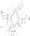
- FIG. 1 is a schematic diagram illustrating the operation of a roadside detection system 100 according to an exemplary embodiment of the disclosure.
- the roadside detection system 100 includes a roadside infrastructure 102.
- the roadside infrastructure 102 includes a roadside unit (RSU) 104 and at least one sensor 106.
- the sensor 106 may be a sensing device, such as a radar 106a, a camera 106b or a combination thereof.
- the sensor 106 may be equipped on the roadsides or at crossroads.
- the sensor 106 detects at least one object within a detection range, and collects object information of the object at at least two time points t1 and t2. For example, the sensor 106 detects, but not limited to, cars, motorbikes, bicycles or pedestrians within the detection range.
- the roadside unit 104 receives positioning signals from a satellite positioning system to obtain roadside latitude and longitude coordinates ( RSU _ lat , RSU _ long ) and initialization parameter coordinates ( BX, BY ) of the roadside unit 104.
- the roadside latitude and longitude coordinates ( RSU _ lat , RSU _ long ) are absolute position coordinates of the roadside unit 104.
- the roadside unit 104 receives and collects object information of the object detected by the sensor 106 at at least two time points t1 and t2 over wired or wireless networks, and obtains object latitude and longitude coordinates, an object speed, an object acceleration, an object length and an object heading/direction of the object according to the roadside latitude and longitude coordinates ( RSU _ lat , RSU _ long ) and the object information of the object.
- the roadside unit 104 then converts the object latitude and longitude coordinates, the object speed, the object acceleration, the object length and the object heading/direction of the object into a standard V2V Basic Safety Message (BSM) format, and broadcasts the V2V message in a Roadside-to-Vehicle (R2V) communication mode.
- BSM Basic Safety Message
- R2V Roadside-to-Vehicle
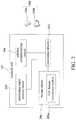
- FIG. 2 is a functional block diagram of a roadside unit 104 according to an exemplary embodiment of the disclosure.
- the roadside unit 104 includes a processing circuitry 202, a wireless communication circuit 204, a storage circuit 206 and a positioning signal receiver circuit 208.
- the processing circuitry 202 controls the operation of the roadside unit 104.
- the processing circuitry 202 is, for example, but not limited to, a central processing unit (CPU), a programmable microprocessor, a digital signal processor (DSP), a programmable controller, an application specific integrated circuits (ASIC), a programmable logic device (PLD), or the like.
- the positioning signal receiver circuit 208 is coupled to the processing circuitry 202, and receives positioning signals from satellites of a satellite positioning system.
- the positioning signal receiver circuit 208 supports communication protocols of, for example, a Global Positioning System (GPS), an Assisted Global Positioning system (AGPS), a Galileo positioning system or a Global Navigation Satellite System (GLONASS).
- GPS Global Positioning System
- AGPS Assisted Global Positioning system
- GLONASS Global Navigation Satellite System
- the wireless communication circuit 204 is coupled to the processing circuitry 202 and broadcasts V2V messages.
- the wireless communication circuit 204 may further receive object information of each object detected by the sensor 106 when the roadside unit 104 and the sensor 106 are equipped at different positions or the roadside unit 104 and the sensor 106 communicate over the wireless network.
- the wireless communication circuit 204 is a communication chip supporting, for example, a Global System for Mobile Communication (GSM) system, a Personal Handy-phone System (PHS), a Code Division Multiple Access (CDMA) system, a Wireless Fidelity (WiFi) system, a Worldwide Interoperability for Microwave Access (WiMAX) system, Third-Generation Wireless communication technology (3G), Long Term Evolution (LTE), Wireless Access in Vehicular Environments/Dedicated Short Range Communication (WAVE/DSRC), and a combination thereof.
- the storage circuit 206 is coupled to the processing circuitry 202 and stores program codes of the roadside unit 104 and the received object information.
- the storage circuit 206 is, for example, a storage device, such as a hard drive and a flash memory.
- the roadside unit 104 converts the object latitude and longitude coordinates, the object speed, the object acceleration, the object length and the object heading/direction of the object into a standard V2V Basic Safety Message (BSM) format via a vehicle-to-vehicle (V2V) format conversion module 206a having program codes.
- the V2V format conversion module 206a is implemented by, for example, software, and is stored in the storage circuit 206.
- the processing circuitry 202 loads the program codes of the V2V format conversion module 206a from the storage circuit 206, and executes the function of converting the object latitude and longitude coordinates, the object speed, the object acceleration, the object length and the object heading/direction of the object into the standard V2V Basic Safety Message (BSM) format.
- BSM V2V Basic Safety Message
- the function of converting the object latitude and longitude coordinates, the object speed, the object acceleration, the object length and the object heading/direction of the object into the standard V2V Basic Safety Message (BSM) format can also be implemented in a hardware circuit such as the processing circuitry 202.
- the sensor 106 may be an equipment, such as a radar 106a, a camera 106b or a combination thereof.
- the object information detected by the sensor 106 includes, but not limited to, a relative position and a relative speed between the object and the roadside unit, and object lengths of the object.
- the radar 106a detects all objects within a detection range via radar detection technology to obtain object information of the objects detected.
- the object information may include a relative position (a relative movement coordinate) and a relative speed between the objects and the roadside unit 104, and object lengths of the objects.
- the roadside unit 104 receives object information of each object at at least two time points transmitted from the radar 106a, converts each relative position of each object at the at least two time points into object latitude and longitude coordinates of the two time points, and further obtains an object speed, an object acceleration, an object length and an object heading/direction of each object according to the object latitude and longitude coordinates and the object information.
- object information of each object at at least two time points transmitted from the radar 106a
- converts each relative position of each object at the at least two time points into object latitude and longitude coordinates of the two time points and further obtains an object speed, an object acceleration, an object length and an object heading/direction of each object according to the object latitude and longitude coordinates and the object information.
- the camera 106b by using image identification technology, the camera 106b identifies objects from images that it captures, obtains object information of the objects, calculates the relative position and the relative speed of the objects and the roadside unit 104, and object information such as an object length of the object, and transmits the object information of the objects to the roadside unit 104.
- the roadside unit 104 acquires the GPS coordinate of the camera 106b in advance, and receives image information from the camera 106b.
- the roadside unit 104 then identifies the objects in the images by the image identification technology, calculates the relative position and the relative speed of the object and the roadside unit 104, and object information such as object length of the object, and further obtains the object latitude and longitude coordinates, the object speed, the object acceleration, the object length and the object heading/direction of the objects.
- object information such as object length of the object
- the disclosure does not limit the configuration of the sensor 106, and any sensor can be used in the disclosure as long as the sensor can transmit the detected object information to the roadside unit 104, allowing the roadside unit 104 to convert the object latitude and longitude coordinates, the object speed, the object acceleration, the object length and the object heading/direction of the object into a V2V Basic Safety Message format.
- the roadside unit 104 encodes the object latitude and longitude coordinates, the object speed, the object acceleration, the object length and object heading/direction into a standard V2V Basic Safety Message format.
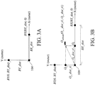
- FIG. 3A is a schematic diagram illustrating a relative position of a roadside unit and initialization parameter coordinates according to an exemplary embodiment of the disclosure.
- FIG. 3B is a schematic diagram illustrating a relative position of a vehicle and a roadside unit, and initialization parameter coordinates according to an exemplary embodiment of the disclosure.
- the positioning signal receiver circuit 208 receives positioning signals to obtain roadside latitude and longitude coordinates (RSU_lat, RSU _ long ) and initialization parameter coordinates ( BX , BY ) of the roadside unit 104.
- the reference coordinate parameter BX of the initialization parameter coordinates ( BX, BY ) takes the roadside unit 104 as a starting point, and obtains the distance BX_ dist away from the roadside unit 104 within a distance range such as a range from 10 meters to 100 meters in X-axis direction.
- the reference coordinate parameter BY of the initialization parameter coordinates ( BX , BY ) also takes the roadside unit 104 as a starting point, and obtains the distance BY_ dist away from the roadside unit 104 within a distance range such as a range from 10 meters to 100 meters in Y-axis direction.
- the roadside unit 104 receives the objection information of the objects.
- the object information of each of the objects includes the information of the object detected by the sensor 106 at at least two time points.
- the processing circuitry 202 of the roadside unit 104 obtains the object latitude and longitude coordinates, the object speed, the object acceleration, the object length and the object heading/direction of the object according to the roadside latitude and longitude coordinates ( RSU_lat, RSU _ long ), the initialization parameter coordinates ( BX , BY ) and the object information, packages these information into a packet, and transmits the packet via the wireless communication circuit 204 by DSRC communication technology.
- the roadside unit 104 may transmit the packet via other communication standards. The following describes how to obtain the object latitude and longitude coordinates, the object speed, the object acceleration, the object length and the object heading/direction of the object.
- the processing circuitry 202 of the roadside unit 104 calculates the distances (unit: meters) of the roadside unit 104 and the initialization parameter coordinates ( BX , BY ) away from zero degree longitude and zero degree latitude, respectively.
- the roadside unit 104 obtains the distance R d _lat of the roadside unit 104 away from zero degree latitude , and the distance R d _long of the roadside unit 104 away from zero degree longitude.
- the distance of the reference coordinate parameter BX away from the roadside unit 104 is BX _dist.
- the distance of the reference coordinate parameter BX away from zero degree latitude is BX d _lat.
- the distance of the reference coordinate parameter BX away from zero degree longitude is BX d _long.
- the distance of the reference coordinate parameter BY away from the roadside unit 104 is BY_ dist.
- the distance of the reference coordinate parameter BY away from zero degree latitude is BY d _ lat.
- the distance of the reference coordinate parameter BY away from zero degree longitude is BY d _ long.
- the processing circuitry 202 of the roadside unit 104 calculates the object latitude and longitude coordinates of the object at at least two time points.
- the sensor 106 detects a vehicle O vehicle , the object information of which comprises a relative position coordinate ( O x _ dist_tl, O y _dist_tl) of the vehicle O vehicle and the roadside unit 104.
- the processing circuitry 202 calculates distances (unit: meters) of the vehicle O vehicle having the relative position coordinate ( O x _dist_t1, O y _dist_t1 ) at the first time point t1 away from zero degree longitude and zero degree latitude, respectively.
- the roadside unit 104 obtains the object latitude and longitude coordinates, i.e., the absolute longitude and latitude coordinates of the object, at the first time point t1, via the equations (1) and (2), according to the roadside latitude and longitude coordinates ( RSU_lat, RSU _ long ), the initialization parameter coordinates ( BX, BY ) and the object information (the distances O d _lat_t1 and O d _long_t1 of the vehicle O vehicle away from zero degree longitude and zero degree longitude, respectively).
- the roadside unit 104 obtains the object latitude and longitude coordinates at the second time point t2, via the equations (1) and (2), according to the roadside latitude and longitude coordinates ( RSU_lat, RSU _ long ), the initialization parameter coordinates (BX, BY) and the object information (the distances O d _lat_t2 and O d _long_t2 of the vehicle O vehicle away from zero degree latitude and zero degree longitude, respectively).
- FIG. 4A is a schematic diagram illustrating the position of a vehicle at first time point and second time point according to an exemplary embodiment of the disclosure.
- FIG 4B is a schematic diagram illustrating a vehicle having a moving direction changed to north heading angle according to an exemplary embodiment of the disclosure.
- the processing circuitry 202 of the roadside unit 104 obtains, via the equations (1) and (2), the distances O d _lat_t1 and O d _long_t1 of the vehicle O vehicle away from zero degree latitude and zero degree longitude, respectively, at the first time point t1, and the distances O d _lat_t2 and O d _long_t2 of the vehicle O vehicle away from zero degree latitude and zero degree longitude, respectively, at the second time point t2, and changes the moving direction of the vehicle O vehicle to a north heading angle according to the moving direction of the vehicle O vehicle , i.e., the moving direction of vehicle O vehicle at the position O vehicle_t1 of the first time point t1 toward the position O vehicle _t2 at the second time point t2.
- Taiwan i.e., 120-122 degrees east longitude and 22-25 degrees north latitude
- the disclosure is not limited thereto, and the heading angle of the object is not limited to north.
- the processing circuitry 202 of the roadside unit 104 calculates the speed and acceleration of the object according to the object information transmitted by the sensor 106. Take the vehicle O vehicle as an example.
- the roadside unit 104 acquires, from the object information transmitted by the sensor 106, that the relative position coordinate of the vehicle O vehicle at the first time point t1 is ( O x _dist_t1, O y_ dist _ t1 ) and the relative position coordinate of the vehicle O vehicle at the second time point t2 is ( O x_ dist_t2, O y _dist t2 ), and further obtains the object speed V and the object acceleration a of the vehicle O vehicle .
- the roadside unit 104 can obtain the object speed V via the relative speed of the object. For example, the sensor 106 detects that the relative speeds of the vehicle O vehicle at the first time point t1 along the X axis and the Y axis are V x_t1 and V y_t1 , respectively, and the roadside unit 104 can thus calculate the speed V_t1 and the acceleration a of the vehicle O vehicle .
- the roadside unit 104 stores the received object information and the object latitude and longitude coordinates, the object speed, the object acceleration, the object length and the object heading/direction of the object in the storage circuit 206.
- the processing circuitry 202 of the roadside unit 104 converts, the object latitude and longitude coordinates, the object speed, the object acceleration, the object length and the object heading/direction of the object into a standard V2V Basic Safety Message (BSM) format, and the roadside unit 104 broadcasts the V2V messages in the Roadside-to-Vehicle (R2V) communication mode.
- BSM V2V Basic Safety Message
- the sensor 106 and the roadside unit 104 are equipped at the same position.
- the sensor 106 can be built in the roadside unit 104.
- the sensor 106 and the roadside unit 104 have identical GPS coordinates. Therefore, the sensor 106 transmits the detected object information including the relative position and the relative speed of the object and the roadside unit and the object lengths of the object to the roadside unit 104, and the roadside unit 104 can obtain the object latitude and longitude coordinates, the object speed, the object acceleration and the object heading/direction of the object, based on the above description.
- the sensor 106 and the roadside unit 104 are equipped at different positions.
- the roadside unit 104 can acquire the GPS coordinate of the sensor 106 in advance, or receives the GPS coordinate and the object information from the sensor 106. Therefore, the roadside unit 104 can obtain the object latitude and longitude coordinates, the object speed, the object acceleration, the object length and the object heading/direction of the object according to the GPS coordinate of the sensor 106 and the object information received by the sensor 106.
- a vehicle equipped with an On-board Unit (OBU) and configured to receive V2V messages can receive packets transmitted from the roadside unit 104 that comprise V2V Basic Safety Message format. Therefore, the vehicle equipped with the OBU can be made aware of all the coming objects (e.g., cars, motorbikes, bicycles, or pedestrians) via the received V2V Basic Safety Message. The vehicle equipped with the OBU can then release a warning message if it determines that the coming object is too close in order to protect itself from colliding with the object.
- OBU On-board Unit
- the roadside unit 104 that converts the object information at the crossroads into the V2V Basic Safety Message and informs vehicles nearby of the V2V Basic Safety Message, the problems due to low popularity of the OBU and that not every vehicle or object has the function of transmitting the V2V Basic Safety Message are solved..
- FIG. 5 is a flow chart of a roadside communication method according to an exemplary embodiment of the disclosure.
- step S501 the roadside unit 104 receives positioning signals from a satellite positioning system to obtain roadside latitude and longitude coordinates ( RSU _ lat , RSU_long ) and initialization parameter coordinates ( BX, BY ) of the roadside unit.
- step S503 the roadside unit 104 receives, from the sensor 106, object information of at least one object that includes information of the object detected by the sensor 106 at at least two time points.
- step S505 the roadside unit 104 obtains object latitude and longitude coordinates, an object speed, an object acceleration, an object length and an object heading/direction of the object according to the roadside latitude and longitude coordinates ( RSU _ lat , RSU_long ), the initialization parameter coordinates ( BX, BY ) and the object information of the object.
- step S507 the roadside unit 104 converts the object latitude and longitude coordinates, the object speed, the object acceleration, the object length and the object heading/direction of the object into a Vehicle-to-Vehicle Basic Safety Message format.
- the roadside detection system, the roadside unit and the roadside communication method in the exemplary embodiments employ the roadside unit to detect objects and release V2V messages, such that neighboring vehicles or objects can be made aware of one another via the V2V messages from the roadside unit, thereby reducing the occurrence of accidents, and solving the problem caused by the low popularity of the OBU.
Landscapes
- Physics & Mathematics (AREA)
- General Physics & Mathematics (AREA)
- Engineering & Computer Science (AREA)
- Radar, Positioning & Navigation (AREA)
- Remote Sensing (AREA)
- Computer Networks & Wireless Communication (AREA)
- Electromagnetism (AREA)
- Signal Processing (AREA)
- Life Sciences & Earth Sciences (AREA)
- Atmospheric Sciences (AREA)
- Traffic Control Systems (AREA)
Applications Claiming Priority (1)
| Application Number | Priority Date | Filing Date | Title |
|---|---|---|---|
| TW105128762A TWI662252B (zh) | 2016-09-06 | 2016-09-06 | 路側偵測系統、路側裝置及其路側通訊方法 |
Publications (1)
| Publication Number | Publication Date |
|---|---|
| EP3291204A1 true EP3291204A1 (de) | 2018-03-07 |
Family
ID=57749864
Family Applications (1)
| Application Number | Title | Priority Date | Filing Date |
|---|---|---|---|
| EP17150523.3A Ceased EP3291204A1 (de) | 2016-09-06 | 2017-01-06 | Strassenranddetektionssystem, strassenrandeinheit und strassenrandkommunikationsverfahren dafür |
Country Status (4)
| Country | Link |
|---|---|
| US (1) | US10096244B2 (de) |
| EP (1) | EP3291204A1 (de) |
| CN (1) | CN107798897A (de) |
| TW (1) | TWI662252B (de) |
Cited By (1)
| Publication number | Priority date | Publication date | Assignee | Title |
|---|---|---|---|---|
| US11099272B2 (en) * | 2018-08-31 | 2021-08-24 | Beijing Online Network Technology (Beijing) Co., Ltd. | Intelligent roadside unit |
Families Citing this family (24)
| Publication number | Priority date | Publication date | Assignee | Title |
|---|---|---|---|---|
| CN108347691B (zh) * | 2017-01-24 | 2021-10-26 | 华为技术有限公司 | 一种定位方法及设备 |
| JP2018173688A (ja) * | 2017-03-31 | 2018-11-08 | パナソニックIpマネジメント株式会社 | 路側機 |
| US20190043359A1 (en) * | 2017-08-03 | 2019-02-07 | Laird Technologies, Inc. | Sensor-equipped traffic safety message systems and related methods |
| EP3471075B1 (de) * | 2017-10-16 | 2025-01-15 | Volkswagen Aktiengesellschaft | Verfahren zur kollisionsvermeidung zwischen einem fahrzeug gefährdeter strassenbenutzer und einem umgebenden fahrzeug, fahrzeug für gefährdete strassenbenutzer, weiteres fahrzeug und computerprogramm |
| JP7015723B2 (ja) * | 2018-04-11 | 2022-02-03 | パナソニック株式会社 | 物体検出装置、物体検出システム、及び物体検出方法 |
| US11341850B2 (en) * | 2018-06-18 | 2022-05-24 | Roger Andre EILERTSEN | Road traffic navigation system |
| CN108717788A (zh) * | 2018-07-23 | 2018-10-30 | 王冰子 | 一种智能红绿灯及交通设备的集成信息处理系统 |
| JP7211674B2 (ja) * | 2018-09-27 | 2023-01-24 | 株式会社Subaru | 移動体監視装置、並びにこれを用いる車両制御システムおよび交通システム |
| WO2020071995A1 (en) * | 2018-10-02 | 2020-04-09 | Ncs Pte. Ltd. | Real time vehicle location system |
| CN109829991B (zh) * | 2018-12-27 | 2021-12-03 | 北京万集科技股份有限公司 | 信息的获取方法、装置及系统 |
| CN109856591A (zh) * | 2019-01-24 | 2019-06-07 | 腾讯科技(深圳)有限公司 | 移动终端的定位方法、装置、计算机可读介质及电子设备 |
| CN109785642A (zh) * | 2019-03-18 | 2019-05-21 | 解保业 | 车辆智能诱导系统 |
| CN110971650B (zh) * | 2019-03-25 | 2022-01-11 | 重庆长安汽车股份有限公司 | 基于v2x系统的协同感知系统、方法及车辆 |
| CN110174093B (zh) * | 2019-05-05 | 2022-10-28 | 腾讯科技(深圳)有限公司 | 定位方法、装置、设备和计算机可读存储介质 |
| US10873840B1 (en) * | 2019-07-30 | 2020-12-22 | Continental Teves Ag & Co. Ohg | Communication apparatus for vehicle-to-X communication, method and use |
| CN110634286A (zh) * | 2019-08-16 | 2019-12-31 | 北京千方科技股份有限公司 | 应用于v2x场景的信息处理方法及设备 |
| DE102019127930B4 (de) | 2019-10-16 | 2022-01-20 | Audi Ag | Verfahren zur Positionsbestimmung eines nichtmotorisierten Verkehrsteilnehmers und Verkehrseinrichtung |
| CN111354193B (zh) * | 2020-02-26 | 2021-09-10 | 江苏大学 | 一种基于5g通信的高速公路车辆异常行为预警系统 |
| CN113810881B (zh) | 2020-06-11 | 2026-01-23 | 中兴通讯股份有限公司 | 信息交互方法、服务器、非obu车载终端及存储介质 |
| CN112346079A (zh) * | 2020-10-22 | 2021-02-09 | 芜湖雄狮汽车科技有限公司 | 路侧设备及其辅助定位方法、车辆和存储介质 |
| CN112163720A (zh) * | 2020-10-22 | 2021-01-01 | 哈尔滨工程大学 | 基于车联网的多智能体无人驾驶电动汽车换电调度方法 |
| US20230032998A1 (en) * | 2021-07-30 | 2023-02-02 | Magna Electronics Inc. | Vehicular object detection and door opening warning system |
| JP7537411B2 (ja) * | 2021-11-11 | 2024-08-21 | トヨタ自動車株式会社 | 情報処理システム、情報処理方法、及びプログラム |
| US20240112569A1 (en) * | 2022-09-29 | 2024-04-04 | Magna Electronics Inc. | Vehicular sensing system and control system utilizing short range communication with transmitters at the road or traffic signs |
Citations (3)
| Publication number | Priority date | Publication date | Assignee | Title |
|---|---|---|---|---|
| JP2014137321A (ja) * | 2013-01-18 | 2014-07-28 | Nec Corp | 位置座標変換システム、位置座標変換方法、車載装置、世界座標計測装置および位置座標変換プログラム |
| US20160210525A1 (en) * | 2015-01-16 | 2016-07-21 | Qualcomm Incorporated | Object detection using location data and scale space representations of image data |
| CN110634286A (zh) * | 2019-08-16 | 2019-12-31 | 北京千方科技股份有限公司 | 应用于v2x场景的信息处理方法及设备 |
Family Cites Families (31)
| Publication number | Priority date | Publication date | Assignee | Title |
|---|---|---|---|---|
| JPH0894320A (ja) * | 1994-09-28 | 1996-04-12 | Nec Corp | 移動物体計測装置 |
| US8282549B2 (en) | 2003-12-09 | 2012-10-09 | Dexcom, Inc. | Signal processing for continuous analyte sensor |
| CN100369073C (zh) * | 2005-12-06 | 2008-02-13 | 北京工业大学 | 基于视频技术的路侧停车场管理系统 |
| CN100492434C (zh) | 2006-11-30 | 2009-05-27 | 上海交通大学 | 交通流状态分析所需的探测车采样量的获取方法 |
| US8165748B2 (en) * | 2006-12-05 | 2012-04-24 | Kabushiki Kaisha Kenwood | Information providing system, information providing method, and computer program |
| CN200997188Y (zh) * | 2006-12-19 | 2007-12-26 | 交通部公路科学研究所 | 路侧交通标志车载信息辅助装置 |
| KR100986372B1 (ko) * | 2007-11-28 | 2010-10-08 | 현대자동차주식회사 | 교통정보 수집용 단말기 및 교통정보 생성방법 |
| US20100100324A1 (en) | 2008-10-22 | 2010-04-22 | Toyota Motor Engineering & Manufacturing North America, Inc. | Communication based vehicle-pedestrian collision warning system |
| TW201020140A (en) * | 2008-11-28 | 2010-06-01 | Automotive Res & Testing Ct | Vehicle traveling safety assistant network management system and method |
| CN101571400A (zh) * | 2009-01-04 | 2009-11-04 | 四川川大智胜软件股份有限公司 | 基于动态交通信息的嵌入式车载组合导航系统 |
| KR100948382B1 (ko) * | 2009-07-28 | 2010-03-22 | 경북대학교 산학협력단 | 방범 서비스 방법 및 시스템 |
| JP2012010036A (ja) * | 2010-06-23 | 2012-01-12 | Toshiba Corp | カメラキャリブレーションシステムと、その計測車両及び路側機 |
| CN102339531B (zh) | 2010-07-14 | 2014-11-05 | 数伦计算机技术(上海)有限公司 | 路边交通探测系统 |
| DE102010049091A1 (de) | 2010-10-21 | 2012-04-26 | Gm Global Technology Operations Llc (N.D.Ges.D. Staates Delaware) | Verfahren zum Betreiben zumindest eines Sensors eines Fahrzeugs und Fahrzeug mit zumindest einem Sensor |
| DE102010049093A1 (de) | 2010-10-21 | 2012-04-26 | Gm Global Technology Operations Llc (N.D.Ges.D. Staates Delaware) | Verfahren zum Betreiben zumindest eines Sensors eines Fahrzeugs und Fahrzeug mit zumindest einem Sensor |
| CN102431556B (zh) | 2011-11-15 | 2015-09-30 | 武汉理工大学 | 基于车路协同的驾驶员一体化预警装置 |
| US9253753B2 (en) * | 2012-04-24 | 2016-02-02 | Zetta Research And Development Llc-Forc Series | Vehicle-to-vehicle safety transceiver using time slots |
| US20130278441A1 (en) | 2012-04-24 | 2013-10-24 | Zetta Research and Development, LLC - ForC Series | Vehicle proxying |
| CN102857573B (zh) * | 2012-09-17 | 2016-05-18 | 广州杰赛科技股份有限公司 | 用于车载通信的安全鉴别方法和系统 |
| CN102928861B (zh) * | 2012-09-29 | 2015-05-06 | 凯迈(洛阳)测控有限公司 | 机载设备用目标定位方法及装置 |
| TWI453449B (zh) | 2012-12-27 | 2014-09-21 | Ind Tech Res Inst | 協同式定位校正系統與方法及參考站佈建方法 |
| EP2793041A1 (de) * | 2013-04-15 | 2014-10-22 | Nederlandse Organisatie voor toegepast -natuurwetenschappelijk onderzoek TNO | Gesicherte Fahrzeugabsolutlokalisierung |
| US8990001B2 (en) | 2013-07-26 | 2015-03-24 | Nissan North America, Inc. | Vehicle collision monitoring method |
| TWI503560B (zh) * | 2013-12-25 | 2015-10-11 | 財團法人工業技術研究院 | 移動車輛定位校正方法與裝置 |
| US9460625B2 (en) | 2014-04-08 | 2016-10-04 | Denso International America, Inc. | Proxy DSRC basic safety message for unequipped vehicles |
| US9729636B2 (en) * | 2014-08-01 | 2017-08-08 | Magna Electronics Inc. | Smart road system for vehicles |
| CN104376735B (zh) | 2014-11-21 | 2016-10-12 | 中国科学院合肥物质科学研究院 | 一种盲区路口车辆行驶安全预警系统及其预警方法 |
| US10035509B2 (en) * | 2015-08-06 | 2018-07-31 | Safer Technology Solutions LLC | Early warning intersection device |
| CN105976609A (zh) * | 2015-11-06 | 2016-09-28 | 乐卡汽车智能科技(北京)有限公司 | 一种车辆数据处理系统及方法 |
| CN105427610B (zh) * | 2015-12-31 | 2018-01-30 | 招商局重庆交通科研设计院有限公司 | 一种基于车路协同技术的交通管理方法 |
| CN105513425B (zh) | 2016-01-18 | 2018-02-27 | 江苏大学 | 一种车辆碰撞风险算法及事故预警方法 |
-
2016
- 2016-09-06 TW TW105128762A patent/TWI662252B/zh active
- 2016-10-12 CN CN201610889343.7A patent/CN107798897A/zh active Pending
-
2017
- 2017-01-06 EP EP17150523.3A patent/EP3291204A1/de not_active Ceased
- 2017-01-09 US US15/401,353 patent/US10096244B2/en active Active
Patent Citations (3)
| Publication number | Priority date | Publication date | Assignee | Title |
|---|---|---|---|---|
| JP2014137321A (ja) * | 2013-01-18 | 2014-07-28 | Nec Corp | 位置座標変換システム、位置座標変換方法、車載装置、世界座標計測装置および位置座標変換プログラム |
| US20160210525A1 (en) * | 2015-01-16 | 2016-07-21 | Qualcomm Incorporated | Object detection using location data and scale space representations of image data |
| CN110634286A (zh) * | 2019-08-16 | 2019-12-31 | 北京千方科技股份有限公司 | 应用于v2x场景的信息处理方法及设备 |
Non-Patent Citations (2)
| Title |
|---|
| CHEN KUAN-WEN ET AL: "Object Detection for Neighbor Map Construction in an IoV System", 2014 IEEE INTERNATIONAL CONFERENCE ON INTERNET OF THINGS(ITHINGS), AND IEEE GREEN COMPUTING AND COMMUNICATIONS (GREENCOM) AND IEEE CYBER, PHYSICAL AND SOCIAL COMPUTING (CPSCOM), IEEE, 1 September 2014 (2014-09-01), pages 300 - 303, XP032747577, ISBN: 978-1-4799-5967-9, [retrieved on 20150312], DOI: 10.1109/ITHINGS.2014.54 * |
| VLASTARAS DIMITRIOS ET AL: "Universal medium range radar and IEEE 802.11p modem solution for integrated traffic safety", 2013 13TH INTERNATIONAL CONFERENCE ON ITS TELECOMMUNICATIONS (ITST), IEEE, 5 November 2013 (2013-11-05), pages 193 - 197, XP032532129, DOI: 10.1109/ITST.2013.6685544 * |
Cited By (1)
| Publication number | Priority date | Publication date | Assignee | Title |
|---|---|---|---|---|
| US11099272B2 (en) * | 2018-08-31 | 2021-08-24 | Beijing Online Network Technology (Beijing) Co., Ltd. | Intelligent roadside unit |
Also Published As
| Publication number | Publication date |
|---|---|
| US20180068562A1 (en) | 2018-03-08 |
| TW201812252A (zh) | 2018-04-01 |
| US10096244B2 (en) | 2018-10-09 |
| TWI662252B (zh) | 2019-06-11 |
| CN107798897A (zh) | 2018-03-13 |
Similar Documents
| Publication | Publication Date | Title |
|---|---|---|
| US10096244B2 (en) | Roadside detection system, roadside unit and roadside communication method thereof | |
| US11194057B2 (en) | ASIL-classification by cooperative positioning | |
| EP3300055A1 (de) | Strassenrandanzeigesystem, strassenrandeinheit und strassenrandanzeigeverfahren dafür | |
| JP6219312B2 (ja) | 道路の車線の車線交通路内の車両の位置を決定する方法、並びに2つの車両間の整列及び衝突リスクを検知する方法 | |
| KR102099745B1 (ko) | 차량-대-차량 인터페이스를 통해 교통 체증의 종료에 관한 유용한 정보를 생성하는 장치, 방법 및 컴퓨터 프로그램 | |
| CN111699523B (zh) | 信息生成装置、信息生成方法、计算机程序和车内装置 | |
| JP6260912B2 (ja) | 渋滞箇所情報提供のための装置、方法、及びプログラム | |
| JP2006279859A (ja) | 移動体移動実態情報提供システム、位置情報収集装置、カーナビ装置および移動体移動実態情報提供方法 | |
| US20180190125A1 (en) | Real-time relative vehicle trajectories using vehicle to vehicle communication | |
| CN111915921A (zh) | 利用路侧设备的车道级精度定位方法 | |
| WO2023177941A1 (en) | User equipment (ue) based relative position | |
| KR101850254B1 (ko) | 커넥티드 카 환경을 지원하기 위한 차량간 통신 시스템 | |
| US20190043359A1 (en) | Sensor-equipped traffic safety message systems and related methods | |
| JP5104372B2 (ja) | 車車間通信システム、車車間通信装置 | |
| US10737618B2 (en) | Device and method for identifying relative position between objects | |
| JP2017123072A (ja) | 運転支援装置及びコンピュータプログラム | |
| US20190243367A1 (en) | Precise Localization And V2X Communication For Autonomous Driving Vehicles | |
| JP2017107463A (ja) | 歩行者端末装置、通信システムおよび歩行者位置取得方法 | |
| EP3965395B1 (de) | Vorrichtung, verfahren und computerprogramm für ein erstes fahrzeug und zum schätzen einer position eines zweiten fahrzeugs am ersten fahrzeug, fahrzeug | |
| JP6714944B2 (ja) | 運転支援装置、運転支援プログラム、運転支援方法および運転支援システム | |
| Hussain et al. | Development and demonstration of merge assist system using connected vehicle technology | |
| JP2007108837A (ja) | 車載通信装置及び車両間通信システム | |
| WO2023176587A1 (ja) | 交通通信システム、第1の端末、プログラム、及び通信方法 | |
| WO2023112238A1 (ja) | 通信システム、通信方法及び記憶媒体 |
Legal Events
| Date | Code | Title | Description |
|---|---|---|---|
| PUAI | Public reference made under article 153(3) epc to a published international application that has entered the european phase |
Free format text: ORIGINAL CODE: 0009012 |
|
| STAA | Information on the status of an ep patent application or granted ep patent |
Free format text: STATUS: REQUEST FOR EXAMINATION WAS MADE |
|
| 17P | Request for examination filed |
Effective date: 20170106 |
|
| AK | Designated contracting states |
Kind code of ref document: A1 Designated state(s): AL AT BE BG CH CY CZ DE DK EE ES FI FR GB GR HR HU IE IS IT LI LT LU LV MC MK MT NL NO PL PT RO RS SE SI SK SM TR |
|
| AX | Request for extension of the european patent |
Extension state: BA ME |
|
| STAA | Information on the status of an ep patent application or granted ep patent |
Free format text: STATUS: EXAMINATION IS IN PROGRESS |
|
| 17Q | First examination report despatched |
Effective date: 20201023 |
|
| STAA | Information on the status of an ep patent application or granted ep patent |
Free format text: STATUS: THE APPLICATION HAS BEEN REFUSED |
|
| 18R | Application refused |
Effective date: 20240131 |