EP3343431B1 - Procédé et système de localisation de véhicule à partir d'une image de caméra - Google Patents
Procédé et système de localisation de véhicule à partir d'une image de caméra Download PDFInfo
- Publication number
- EP3343431B1 EP3343431B1 EP16207096.5A EP16207096A EP3343431B1 EP 3343431 B1 EP3343431 B1 EP 3343431B1 EP 16207096 A EP16207096 A EP 16207096A EP 3343431 B1 EP3343431 B1 EP 3343431B1
- Authority
- EP
- European Patent Office
- Prior art keywords
- image
- map
- pixel
- classified
- vehicle location
- Prior art date
- Legal status (The legal status is an assumption and is not a legal conclusion. Google has not performed a legal analysis and makes no representation as to the accuracy of the status listed.)
- Active
Links
Images


Classifications
-
- G—PHYSICS
- G06—COMPUTING OR CALCULATING; COUNTING
- G06V—IMAGE OR VIDEO RECOGNITION OR UNDERSTANDING
- G06V10/00—Arrangements for image or video recognition or understanding
- G06V10/70—Arrangements for image or video recognition or understanding using pattern recognition or machine learning
- G06V10/764—Arrangements for image or video recognition or understanding using pattern recognition or machine learning using classification, e.g. of video objects
-
- G—PHYSICS
- G06—COMPUTING OR CALCULATING; COUNTING
- G06V—IMAGE OR VIDEO RECOGNITION OR UNDERSTANDING
- G06V20/00—Scenes; Scene-specific elements
- G06V20/50—Context or environment of the image
- G06V20/56—Context or environment of the image exterior to a vehicle by using sensors mounted on the vehicle
-
- G—PHYSICS
- G06—COMPUTING OR CALCULATING; COUNTING
- G06F—ELECTRIC DIGITAL DATA PROCESSING
- G06F18/00—Pattern recognition
- G06F18/20—Analysing
- G06F18/22—Matching criteria, e.g. proximity measures
-
- G—PHYSICS
- G06—COMPUTING OR CALCULATING; COUNTING
- G06F—ELECTRIC DIGITAL DATA PROCESSING
- G06F18/00—Pattern recognition
- G06F18/20—Analysing
- G06F18/24—Classification techniques
- G06F18/243—Classification techniques relating to the number of classes
- G06F18/2431—Multiple classes
-
- G—PHYSICS
- G06—COMPUTING OR CALCULATING; COUNTING
- G06T—IMAGE DATA PROCESSING OR GENERATION, IN GENERAL
- G06T7/00—Image analysis
- G06T7/70—Determining position or orientation of objects or cameras
- G06T7/73—Determining position or orientation of objects or cameras using feature-based methods
-
- G—PHYSICS
- G06—COMPUTING OR CALCULATING; COUNTING
- G06V—IMAGE OR VIDEO RECOGNITION OR UNDERSTANDING
- G06V10/00—Arrangements for image or video recognition or understanding
- G06V10/70—Arrangements for image or video recognition or understanding using pattern recognition or machine learning
- G06V10/82—Arrangements for image or video recognition or understanding using pattern recognition or machine learning using neural networks
-
- G—PHYSICS
- G06—COMPUTING OR CALCULATING; COUNTING
- G06V—IMAGE OR VIDEO RECOGNITION OR UNDERSTANDING
- G06V20/00—Scenes; Scene-specific elements
- G06V20/50—Context or environment of the image
- G06V20/56—Context or environment of the image exterior to a vehicle by using sensors mounted on the vehicle
- G06V20/58—Recognition of moving objects or obstacles, e.g. vehicles or pedestrians; Recognition of traffic objects, e.g. traffic signs, traffic lights or roads
-
- G—PHYSICS
- G06—COMPUTING OR CALCULATING; COUNTING
- G06V—IMAGE OR VIDEO RECOGNITION OR UNDERSTANDING
- G06V20/00—Scenes; Scene-specific elements
- G06V20/60—Type of objects
- G06V20/64—Three-dimensional [3D] objects
- G06V20/647—Three-dimensional [3D] objects by matching two-dimensional images to three-dimensional objects
-
- G—PHYSICS
- G06—COMPUTING OR CALCULATING; COUNTING
- G06T—IMAGE DATA PROCESSING OR GENERATION, IN GENERAL
- G06T2207/00—Indexing scheme for image analysis or image enhancement
- G06T2207/20—Special algorithmic details
- G06T2207/20081—Training; Learning
-
- G—PHYSICS
- G06—COMPUTING OR CALCULATING; COUNTING
- G06T—IMAGE DATA PROCESSING OR GENERATION, IN GENERAL
- G06T2207/00—Indexing scheme for image analysis or image enhancement
- G06T2207/20—Special algorithmic details
- G06T2207/20084—Artificial neural networks [ANN]
-
- G—PHYSICS
- G06—COMPUTING OR CALCULATING; COUNTING
- G06T—IMAGE DATA PROCESSING OR GENERATION, IN GENERAL
- G06T2207/00—Indexing scheme for image analysis or image enhancement
- G06T2207/30—Subject of image; Context of image processing
- G06T2207/30248—Vehicle exterior or interior
- G06T2207/30252—Vehicle exterior; Vicinity of vehicle
Definitions
- the present invention relates to a method and system for determining the position of a vehicle based on semantically segmented camera images.
- a problem when performing localization using camera images is to create a map which is invariant to the visual changes that occur over time in the environment surrounding the vehicle. Changes in lighting during the day, changing weather, seasonal variation, etc. may cause significant changes in the appearance of the same scene, making it difficult to extract features from the images that remain constant.
- Place recognition is an example of another approach, where one does not localize with the same precision, but where the objective is to get a rough idea of where the image was taken. This approach has proven more robust against temporal changes, but has too low precision to be useful for self driving cars.
- NUCHTER A ET AL "Towards semantic maps for mobile robots", ROBOTICS AND AUTONOMOUS SYSTEMS, ELSEVIER BY, AMSTERDAM, NL, vol. 56, no. 11, 30 November 2008 (2008-11-30), pages 915-926, XP025561288, ISSN: 0921-8890, DOI: 10.1016 describes an approach and an integrated robot system for semantic mapping where the prime sensor is a 3D laser scanner and individual scans are registered into a coherent 3D geometry map by 6D SLAM. Coarse scene features ( e.g., walls, floors in a building) are determined by semantic labeling. More delicate objects are then detected by a trained classifier and localized. In the end, the semantic maps can be visualized for human inspection.
- a method for determining a location of a vehicle according to claim 1.
- the 3D-map is formed prior to using the described method, and the 3D-map is thus stored in the vehicle or otherwise accessible to the vehicle.
- the predetermined set of classes used to classify pixels in the 2D-image is based on predetermined classes existing in the 3D-map.
- the main principle of the described method is that for a given captured 2D-image, the image is matched against the 3D-map for a possible vehicle location.
- Each possible vehicle location corresponds to a point of view in the 3D-map.
- the captured 2D-image is matched against different "viewpoints" in the 3D-map, corresponding to the possible vehicle locations.
- the classified pixels of the 2D-image can be assumed to have the best correspondence with the classified geometric objects of the 3D-map, thereby determining the correct location of the vehicle.
- the present invention is based on the realization that a more efficient method can be achieved by classifying objects in the 3D-map and pixels in the 2D-image, and subsequently matching the classified objects. This removes the requirement of uniquely identifiable objects in the surrounding, which takes up large amounts of storage space since identifiers for each individual object must be stored. Moreover, feature based localization using image feature descriptors to identify objects in images is sensitive to changes in appearance of the image features, meaning that a given descriptor matching algorithm may not recognize an image feature if the appearance has changed. Such variations may occur naturally over time, for example caused by seasonal variations or time of day. Object classification, on the other hand, is easier to make invariant to such variations.
- the classification of the 2D-image can be improved over time to increase the accuracy of the classification and thereby of the location determination.
- the described method provides a method for vehicle localization with increased efficiency and with high accuracy by using object and pixel classification.
- matching may comprise projecting a plurality of geometric objects in the 3D-map onto a 2D-plane, typically the image plane, and comparing a classification of the plurality of geometric objects projected onto the 2D-plane with a classification of at least one corresponding pixel in the classified 2D-image.
- the 2D-plane corresponds to the image plane of the camera from which the 2D-image originated.
- only objects in the 3D map which can be assumed to be visible in the 2D-image are projected onto the 2D-plane. Accordingly, geometrical objects which are not in the line-of-sight of the assumed vehicle position are not projected. Thereby, the amount of objects being projected is reduced, simplifying the matching processing.
- matching may comprise projecting at least one pixel of the 2D-image into the 3D-map to form a conical volume in the 3D-map having a cross section corresponding to a cross section of the pixel.
- a pixel typically has a square cross section, meaning that the four corners of the pixel are projected into the 3D-map to form a cone (i.e. a pyramid) in the 3D-map.
- Matching can thus be performed by comparing the class of the pixel with a class of an object within the projected volume in the 3D-map, if an object is present within the volume.
- determining a matching score may comprise assigning a weight to each geometric object within the conical volume, wherein the weight is based on a distance between the geometrical object and an image plane of the 2D-image in the 3D-map.
- Matching comprises projecting at least one pixel of the 2D-image onto a geometric object in the 3D-map, and comparing a classification of the geometric object with a classification of the projected at least one pixel in the classified 2D-image.
- a location of a point in the 3D-map corresponds to a 2D-point in the image plane.
- the image plane is a plane in a 3D-space where the location of the pixels can be determined by two coordinates. Accordingly, projecting the pixels in the 2D-image into the 3D-map can be seen as forming the image plane in the 3D space.
- classifying pixels of the 2D-image may comprise classifying only pixels in locations of the 2D-image corresponding to locations of geometrical objects in the 3D-map. Accordingly, pixels in the 2D-image can be mapped against corresponding geometrical objects in the 3D-map prior to classification of the pixels, thereby making the method more computationally efficient since fewer pixels require classification.
- the method may further comprise selecting a subset of the classes and matching only pixels and geometrical objects belonging to the subset of classes.
- the classification of pixels is performed, but only pixels belonging to the subset of classes is subsequently matched against geometrical objects in the 3D-map, which in turn makes the location determination faster.
- the selection of a subset of classes may for example be based on an estimated location, if it is known that there are no objects belonging to certain classes in the vicinity of the vehicle. Moreover, a known location of the camera in the vehicle may also be used to select a subset of classes.
- the geometric object in the 3D-map may represented by a point in the 3D-map, and wherein the point corresponds to one pixel in the classified 2D-image.
- the geometric object in the 3D-map may be represented by a surface or a volume in the 3D-map.
- the size of a surface or a volume may correspond to only one pixel.
- each surface or volume will correspond to a plurality of pixels in the classified 2D-image.
- the initial vehicle location may be based on a previous determination of a vehicle location. Accordingly, if the method for determining a location of a vehicle has been executed recently, an approximate position of the vehicle may be known. An estimation of the initial vehicle location may for example be based on a previous determined location in combination with a vehicle velocity.
- the initial vehicle location may be based on a vehicle location acquired from a GPS measurement.
- the initial vehicle location may also be determined based on a combination of the above methods.
- the predetermined set of classes may comprise predetermined semantic classes, meaning that the classes are relatable to actual objects, such as a house, a building or a tree.
- semantic classes meaning that the classes are relatable to actual objects, such as a house, a building or a tree.
- the predetermined set of classes are determined by means of the learning algorithm.
- the set of classes have then been determined in a learning stage of the learning algorithm, which for example may be performed when creating the 3D-map.
- a learning stage of the learning algorithm which for example may be performed when creating the 3D-map.
- the learning algorithm may be a convolutional neural network, which has shown to be well suited for image classification.
- defining a plurality of possible vehicle locations based on the initial estimated vehicle location comprises using a Bayesian filter.
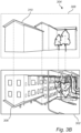
- Fig. 1 is a flow chart outlining the general steps of a method for determining a location of a vehicle according to an embodiment of the invention. The method of Fig. 1 will be discussed with reference to the system 200 illustrated in Fig. 2 , and with reference to Figs. 3A-B schematically illustrating selected steps of the method.
- Fig. 2 illustrates a vehicle 204 comprising a vehicle mounted camera 206 configured to capture an image of the vehicle surroundings, and an image processing unit 208 coupled to the camera 206.
- the camera 206 may be a video camera acquiring a live image feed of the surroundings, or it may be a still camera capturing images at selected intervals or points in time.
- the camera 206 acquires 102 a two-dimensional image, 2D-image, the image depicting a portion of the vehicle surroundings.
- a 2D-image 302 is schematically illustrated in Fig. 3A . It can be assumed that the focal point and orientation of the principal axis of the camera 206 in relation to the vehicle 204 is known.
- the method comprises classifying 104 a plurality of pixels in the image 302 such that each classified pixel belongs to one class out of a predetermined set of classes, thereby forming a classified 2D-image.
- the classification 104 is performed by means of a learning algorithm.
- the classifier determines a probability for each pixel of belonging to each class, i.e. for each pixel there will be N numbers, where N is the number of classes, and for each pixel the N numbers will sum to 1 (since the pixel must have one class).
- Example output for one pixel tree 0.6, building 0.05, ground 0.3, vehicle 0.05 (if we only have those four classes). This can be reduced to one class, by selecting the most likely class.
- a straightforward approach is to classify all of the pixels in the 2D-image. However, it may be possible to only classify a subset of pixels in order to reach a classified 2D-image which is sufficient for accurate matching.
- the present, simplified, example is illustrated using three different semantic classes; "building", “tree”, and “road”, thus defining the predetermined set of classes. Here. It can be assumed that only pixels considered to belong to one of the three classes are given a classification.
- an initial vehicle location is determined 106.
- the initial vehicle location can for example be based on a previously determined vehicle location, based on the described method.
- the initial vehicle location may also be determined based on a GPS-position, and/or on an inertial measurement system or the like.
- a plurality of possible vehicle locations are defined 108.
- the possible vehicle locations may for example be defined using a Bayesian filter, e.g. a bootstrap particle filter. In a Bayesian filter for location, the possible locations are represented by a probability density over a state, and there may be additional elements encoded in the state besides position, such as velocity.
- Bayesian filters are further based on the assumption that there is connection between state distributions over time which can be described by a motion model. It is often assumed that the motion model is a Markov process, meaning that if a distribution is known from a previous time step, no additional information before the previous step is required for modeling the subsequent time step.
- the Bayesian filter may be configured to describe a distribution of possible locations using a number of particles in a particle filter, a point mass filter, an extended Kalman filter or various sigma point filters.
- the following matching 110 step is performed for at least one of the locations, and preferably for a plurality of the possible locations drawn from and representing the location distribution.
- a possible vehicle location defines a vehicle coordinate in the 3D-map.
- the 3D-map is described as being stored on a storage unit 207 in the vehicle 200, thereby being available to the image processing unit 208. However, it is also possible that the 3D-map, or at least parts of the 3D-map, is stored remotely to the vehicle and accessible through wireless communication.
- the classified 2D-image is matched against the 3D-map.
- a pixel in the 2D-image is matched against a geometrical object in the 3D-map, where a geometrical object may be represented by a point, a surface or a volume, i.e. a 1D, 2D or 3D object in the 3D-map, where each object besides its geometric definition also belongs to a class.
- the objects of the 3D-map 304 illustrated in Fig. 3B can be considered to be represented by surfaces, i.e. 2D-objects.
- the matching principle is the same, independent of the dimensionality of the object.
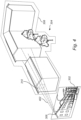
- a pixel 306 in the 2D-image is projected onto the image plane 308 in the 3D-map 304 as schematically illustrated by Fig. 4 .
- the truncated conical volume can be likened with a viewing frustum, having its apex in the focal point, and the image pixel being the truncation surface and then extending into space.
- the conical volume likened with a frustum is illustrated in Fig.
- the shape and direction of the conical volume is defined by the position of the focal point, the location of the pixel in the image, and orientation of the camera 206 acquiring the 2D-image, which in turn is derived from the "possible vehicle location” and the relative position and orientation of the camera 206 relative to the vehicle 204, both of which can be assumed to be readily available.
- the matching is performed between the pixel and the closest object encountered in the conical volume.
- the matching of 3D objects from the map to the 2D image is mathematically described as a projection.
- this projection can be described by a 3 by 4 projection matrix, which is sufficiently defined by the intrinsic and extrinsic model parameters of the camera.
- the images from the camera may need to be rectified if they are subjected to non-linear distortion, in which case model parameters for the rectification are also required.
- the pixel 306 has been classified to belong to the "building" class.
- the pixel 306 is projected onto the image plane from an object of the 3D map, the object here being a surface having the classification "building". Accordingly, there is a match between the class of the pixel 306 and the class of the object 310.
- the 2D-object can for example be represented by triangle mesh, Gaussian processes, a truncated signed distance function or other known 2D-object representations.
- the projection is described as being a projection of the pixel onto a 2D-image plane of the 3D-map.
- this is equivalent with a search for 3D objects in the conical volume in fig. 4 , and it can be assumed that both the matching by 3D to 2D projection and the matching by search in the conical volume created by 2D to 3D projection, provide the same result.
- the class "tree" can be omitted both when classifying the 2D-image and when performing the matching, thereby providing a faster classification and matching process.
- a total matching score is determined 112 for the possible vehicle location.
- the matching score represents the correspondence of an image pixel class of the 2D image with a 3D map object class.
- the total matching score can be determined as a sum of individual pixel scores.
- a pixel score may be set to +1 if there is a match and to -1 if there is no match between the class of the pixel and the class of the corresponding 3D object.
- the specific formula for determining the matching score in principle should be adjusted to the setup of camera, classifier and 3D-map in such a way that the matching score for a pixel represents the logarithm of the measurement likelihood for the same pixel.
- the measurement likelihood function can be determined by comparing a series of classified camera images to a known truth when using a perfect 3D-map of the scene.
- a vehicle location can be determined 114 based on the one or more matching scores.
- the matching score function should be selected so that the total resulting matching score for a selected possible vehicle location correspond to the logarithm of the measurement likelihood in Bayesian filtering theory. Accordingly, the matching score for possible vehicle location correspond to the likelihood that the possible vehicle location is the actual vehicle location.
- standard Bayesian filtering can be used to combine the likelihood with the density from the previous time step into a posterior density. From this posterior density an estimate of position can be extracted by for example finding the maximum of the probability density (MAP estimate), or by minimizing the expected error of the estimate (MMSE estimate).
- MAP estimate the maximum of the probability density
- MMSE estimate the expected error of the estimate
- Fig. 4 schematically illustrates an example embodiment of the method where a pixel 306 of the 2D-image 302 is projected into the 3D-map 304 to form a conical volume 402 in the 3D-map having a cross section corresponding to a cross section of the pixel, which is here a rectangular cross section, thereby providing a pyramidal volume.
- the matching will then comprise comparing the class of the pixel with the class of an object within the conical volume 402.
- the volume 402 intersects the "house" object 310.
- the 3D-map with object classification is pre-existing and available in the vehicle.
- the geometry of the 3D-map can be formed by a 3D-scanner or by structure from motion using cameras.
- the classification of objects in the 3D-map can be achieved by the same procedure as used when localizing, i.e. typically a convolutional neural network performing semantic classification of objects, and then projecting the pixel class onto the 3D objects.
- the classification of objects in the 3D-map can also be done manually or any other way, and this disclosure will not further discuss the creation of the 3D map.
Landscapes
- Engineering & Computer Science (AREA)
- Theoretical Computer Science (AREA)
- General Physics & Mathematics (AREA)
- Physics & Mathematics (AREA)
- Multimedia (AREA)
- Computer Vision & Pattern Recognition (AREA)
- Evolutionary Computation (AREA)
- Artificial Intelligence (AREA)
- Data Mining & Analysis (AREA)
- Health & Medical Sciences (AREA)
- Databases & Information Systems (AREA)
- General Health & Medical Sciences (AREA)
- Medical Informatics (AREA)
- Software Systems (AREA)
- Computing Systems (AREA)
- Life Sciences & Earth Sciences (AREA)
- Bioinformatics & Cheminformatics (AREA)
- Bioinformatics & Computational Biology (AREA)
- Evolutionary Biology (AREA)
- General Engineering & Computer Science (AREA)
- Image Analysis (AREA)
- Traffic Control Systems (AREA)
Claims (17)
- Procédé de détermination d'une position d'un véhicule (204), le procédé comprenant :l'acquisition (102) d'une image bidimensionnelle, notée image 2D, à l'aide d'une caméra (206) embarquée dans le véhicule, ladite image montrant une partie de l'environnement du véhicule ;la classification (104) d'une pluralité de pixels dans ladite image de sorte que chaque pixel classifié appartienne à une classe parmi un ensemble prédéterminé de classes, de manière à former une image 2D classifiée, ladite classification étant réalisée au moyen d'un algorithme d'apprentissage ;la détermination (106) d'une position initiale estimée du véhicule ;la définition (108) d'une pluralité de positions possibles du véhicule sur la base de la position initiale estimée du véhicule ;l'accès à une carte tridimensionnelle, notée carte 3D, préalablement stockée comprenant une pluralité d'objets géométriques, chaque objet géométrique appartenant à une classe parmi ledit ensemble prédéterminé de classes ;l'appariement (110) de l'image 2D classifiée avec la carte 3D, par comparaison d'une classification d'un objet géométrique dans la carte 3D, pour une position possible du véhicule, avec une classification d'au moins un pixel correspondant dans l'image 2D classifiée ;l'appariement comprenant la projection d'au moins un pixel classifié de ladite image 2D sur un objet géométrique dans ladite carte 3D, et la comparaison de la classification de l'objet géométrique avec la classification de l'au moins un pixel projeté dans l'image 2D classifiée ;la détermination (112) d'un score d'appariement pour au moins une position possible du véhicule sur la base d'une pluralité de pixels appariés de ladite image 2D ; etla détermination (114) d'une position du véhicule sur la base du score de l'au moins une position possible du véhicule.
- Procédé selon la revendication 1, dans lequel l'appariement comprend la projection d'une pluralité d'objets géométriques dans ladite carte 3D sur un plan 2D, et la comparaison d'une classification de la pluralité d'objets géométriques projetés sur le plan 2D avec une classification d'au moins un pixel correspondant dans l'image 2D classifiée.
- Procédé selon la revendication 2, dans lequel le plan 2D correspond à un plan image de ladite image 2D.
- Procédé selon la revendication 1, dans lequel l'appariement comprend la projection d'au moins un pixel de ladite image 2D dans ladite carte 3D pour former un volume conique dans ladite carte 3D dont la section transversale correspond à la section transversale dudit pixel.
- Procédé selon la revendication 4, dans lequel la détermination d'un score d'appariement comprend l'assignation d'un poids à chaque objet géométrique au sein dudit volume conique, ledit poids étant basé sur une distance entre l'objet géométrique et un plan image de ladite image 2D dans la carte 3D.
- Procédé selon la revendication 1, dans lequel une position d'un point dans la carte 3D correspond à un point 2D dans le plan image.
- Procédé selon l'une quelconque des revendications précédentes, dans lequel la classification de pixels de ladite image 2D comprend la classification uniquement de pixels dont les positions correspondent aux positions d'objets géométriques dans ladite carte 3D.
- Procédé selon l'une quelconque des revendications précédentes, comprenant en outre la sélection d'un sous-ensemble desdites classes et l'appariement uniquement de pixels et d'objets géométriques appartenant audit sous-ensemble de classes.
- Procédé selon l'une quelconque des revendications précédentes, dans lequel l'objet géométrique dans la carte 3D est représenté par un point dans ladite carte 3D, et dans lequel le point correspond à un pixel dans l'image 2D classifiée.
- Procédé selon l'une quelconque des revendications 1 à 8, dans lequel l'objet géométrique dans la carte 3D est représenté par une surface ou un volume dans ladite carte 3D, et dans lequel la surface ou le volume correspond à une pluralité de pixels dans l'image 2D classifiée.
- Procédé selon l'une quelconque des revendications précédentes, dans lequel la position initiale du véhicule est basée sur une détermination précédente d'une position du véhicule.
- Procédé selon l'une quelconque des revendications 1 à 10, dans lequel la position initiale du véhicule est basée sur une position du véhicule acquise à partir d'une mesure GPS.
- Procédé selon l'une quelconque des revendications précédentes, dans lequel l'ensemble prédéterminé de classes comprend des classes sémantiques prédéterminées.
- Procédé selon l'une quelconque des revendications 1 à 12, dans lequel l'ensemble prédéterminé de classes est déterminé au moyen dudit algorithme d'apprentissage.
- Procédé selon l'une quelconque des revendications précédentes, dans lequel l'algorithme d'apprentissage est un réseau neuronal convolutif.
- Procédé selon l'une quelconque des revendications précédentes, dans lequel la définition d'une pluralité de positions possibles du véhicule sur la base de la position initiale estimée du véhicule comprend l'utilisation d'un filtre bayésien.
- Système (200), à bord d'un véhicule (204), de détermination d'une position d'un véhicule, le système comprenant :une caméra (206) configurée pour acquérir une image bidimensionnelle, notée image 2D, montrant une partie de l'environnement du véhicule ;une unité de stockage (207) sur laquelle est stockée une carte tridimensionnelle, notée carte 3D, comprenant une pluralité d'objets géométriques, chaque objet géométrique appartenant à une classe parmi un ensemble prédéterminé de classes ; etune unité de traitement d'image (208) configurée pour :classifier une pluralité de pixels dans ladite image de sorte que chaque pixel classifié appartienne à une classe parmi ledit ensemble prédéterminé de classes, de manière à former une image 2D classifiée, ladite classification étant réalisée au moyen d'un algorithme d'apprentissage ;déterminer une position initiale estimée du véhicule ;définir une pluralité de positions possibles du véhicule sur la base de la position initiale estimée du véhicule ;accéder à la carte 3D stockée ;apparier l'image 2D classifiée avec la carte 3D en comparant une classification d'un objet géométrique dans la carte 3D, pour une position possible du véhicule, avec une classification d'au moins un pixel correspondant dans l'image 2D classifiée, l'appariement comprenant la projection d'au moins un pixel classifié de ladite image 2D sur un objet géométrique dans ladite carte 3D, et la comparaison de la classification de l'objet géométrique avec la classification de l'au moins un pixel projeté dans l'image 2D classifiée ;déterminer un score d'appariement pour au moins une position possible du véhicule sur la base d'une pluralité de pixels appariés de ladite image 2D ; etdéterminer une position du véhicule sur la base du score de l'au moins une position possible du véhicule.
Priority Applications (5)
| Application Number | Priority Date | Filing Date | Title |
|---|---|---|---|
| EP16207096.5A EP3343431B1 (fr) | 2016-12-28 | 2016-12-28 | Procédé et système de localisation de véhicule à partir d'une image de caméra |
| EP17192794.0A EP3346418A1 (fr) | 2016-12-28 | 2016-12-28 | Procédé et système de localisation de véhicule à partir d'une image de caméra |
| CN202210656183.7A CN115035338A (zh) | 2016-12-28 | 2017-11-27 | 由摄像机图像车辆定位的方法和系统 |
| CN201711202387.9A CN108256411A (zh) | 2016-12-28 | 2017-11-27 | 由摄像机图像车辆定位的方法和系统 |
| US15/850,770 US10467771B2 (en) | 2016-12-28 | 2017-12-21 | Method and system for vehicle localization from camera image |
Applications Claiming Priority (1)
| Application Number | Priority Date | Filing Date | Title |
|---|---|---|---|
| EP16207096.5A EP3343431B1 (fr) | 2016-12-28 | 2016-12-28 | Procédé et système de localisation de véhicule à partir d'une image de caméra |
Related Child Applications (2)
| Application Number | Title | Priority Date | Filing Date |
|---|---|---|---|
| EP17192794.0A Division-Into EP3346418A1 (fr) | 2016-12-28 | 2016-12-28 | Procédé et système de localisation de véhicule à partir d'une image de caméra |
| EP17192794.0A Division EP3346418A1 (fr) | 2016-12-28 | 2016-12-28 | Procédé et système de localisation de véhicule à partir d'une image de caméra |
Publications (2)
| Publication Number | Publication Date |
|---|---|
| EP3343431A1 EP3343431A1 (fr) | 2018-07-04 |
| EP3343431B1 true EP3343431B1 (fr) | 2025-04-30 |
Family
ID=57755060
Family Applications (2)
| Application Number | Title | Priority Date | Filing Date |
|---|---|---|---|
| EP16207096.5A Active EP3343431B1 (fr) | 2016-12-28 | 2016-12-28 | Procédé et système de localisation de véhicule à partir d'une image de caméra |
| EP17192794.0A Withdrawn EP3346418A1 (fr) | 2016-12-28 | 2016-12-28 | Procédé et système de localisation de véhicule à partir d'une image de caméra |
Family Applications After (1)
| Application Number | Title | Priority Date | Filing Date |
|---|---|---|---|
| EP17192794.0A Withdrawn EP3346418A1 (fr) | 2016-12-28 | 2016-12-28 | Procédé et système de localisation de véhicule à partir d'une image de caméra |
Country Status (3)
| Country | Link |
|---|---|
| US (1) | US10467771B2 (fr) |
| EP (2) | EP3343431B1 (fr) |
| CN (2) | CN108256411A (fr) |
Families Citing this family (22)
| Publication number | Priority date | Publication date | Assignee | Title |
|---|---|---|---|---|
| US20180357819A1 (en) * | 2017-06-13 | 2018-12-13 | Fotonation Limited | Method for generating a set of annotated images |
| WO2019185165A1 (fr) * | 2018-03-30 | 2019-10-03 | Toyota Motor Europe | Système et procédé de réglage d'informations de position externe d'un véhicule |
| KR102420568B1 (ko) * | 2018-04-27 | 2022-07-13 | 삼성전자주식회사 | 차량의 위치를 결정하는 방법 및 이를 위한 차량 |
| US10810466B2 (en) * | 2018-08-23 | 2020-10-20 | Fuji Xerox Co., Ltd. | Method for location inference from map images |
| CN110148170A (zh) * | 2018-08-31 | 2019-08-20 | 北京初速度科技有限公司 | 一种应用于车辆定位的定位初始化方法及车载终端 |
| CN109344881B (zh) * | 2018-09-11 | 2021-03-09 | 中国科学技术大学 | 一种基于时空连续性的扩展分类器 |
| CN109376208A (zh) * | 2018-09-18 | 2019-02-22 | 高枫峻 | 一种基于智能终端的定位方法、系统、存储介质及设备 |
| KR102793522B1 (ko) * | 2018-10-24 | 2025-04-09 | 삼성전자주식회사 | 영상 및 맵 데이터 기반 측위 방법 및 장치 |
| DE102018218492A1 (de) * | 2018-10-29 | 2020-04-30 | Robert Bosch Gmbh | Steuergerät, Verfahren und Sensoranordnung zur selbstüberwachten Lokalisierung |
| US11105927B2 (en) | 2018-11-29 | 2021-08-31 | Waymo Llc | Localization initialization for autonomous vehicles |
| DE102019206036A1 (de) * | 2019-04-26 | 2020-10-29 | Volkswagen Aktiengesellschaft | Verfahren und Vorrichtung zur Bestimmung der geografischen Position und Orientierung eines Fahrzeugs |
| US11361505B2 (en) * | 2019-06-06 | 2022-06-14 | Qualcomm Technologies, Inc. | Model retrieval for objects in images using field descriptors |
| CN110660103B (zh) * | 2019-09-17 | 2020-12-25 | 北京三快在线科技有限公司 | 一种无人车定位方法及装置 |
| KR20210071584A (ko) * | 2019-12-06 | 2021-06-16 | 팅크웨어(주) | 위성 항법 시스템 측정 위치의 보정을 통해 위치를 판단하는 위치 측정 방법, 위치 측정 장치 및 이를 수행하는 전자 기기 |
| SE2050258A1 (en) * | 2020-03-06 | 2021-09-07 | Scania Cv Ab | Machine learning based system, methods, and control arrangement for positioning of an agent |
| DE102020111659A1 (de) * | 2020-04-29 | 2021-11-04 | Car.Software Estonia As | Verfahren, System und Computerprogrammprodukt zur Bestimmung der Pose einer mobilen Einheit |
| CN112184818B (zh) * | 2020-10-09 | 2022-06-10 | 重庆邮电大学 | 基于视觉的车辆定位方法及应用其方法的停车场管理系统 |
| EP4012655B1 (fr) * | 2020-12-09 | 2026-01-28 | Martina Baric | Système de positionnement et méthode pour déterminer la position tridimensionnelle d'un objet mobile |
| US11609093B2 (en) | 2021-06-07 | 2023-03-21 | Honeywell International Inc. | Position probability density function filter to determine real-time measurement errors for map based, vision navigation systems |
| CN114543819B (zh) * | 2021-09-16 | 2024-03-26 | 北京小米移动软件有限公司 | 车辆定位方法、装置、电子设备及存储介质 |
| JP7832097B2 (ja) * | 2022-12-05 | 2026-03-17 | 株式会社J-QuAD DYNAMICS | 自己位置推定装置、自己位置推定方法および自己位置推定プログラム |
| CN116630744B (zh) * | 2023-05-22 | 2026-01-23 | 北京达佳互联信息技术有限公司 | 图像生成模型训练方法及图像生成方法、装置及介质 |
Citations (1)
| Publication number | Priority date | Publication date | Assignee | Title |
|---|---|---|---|---|
| EP2132530B1 (fr) * | 2007-03-21 | 2013-08-21 | Universiteit Gent | Système et procédé de localisation |
Family Cites Families (34)
| Publication number | Priority date | Publication date | Assignee | Title |
|---|---|---|---|---|
| KR100520708B1 (ko) * | 2003-10-20 | 2005-10-14 | 엘지전자 주식회사 | 3차원 지도의 표시방법 |
| US7831094B2 (en) * | 2004-04-27 | 2010-11-09 | Honda Motor Co., Ltd. | Simultaneous localization and mapping using multiple view feature descriptors |
| JP2006208223A (ja) * | 2005-01-28 | 2006-08-10 | Aisin Aw Co Ltd | 車両位置認識装置及び車両位置認識方法 |
| US7855723B2 (en) * | 2006-03-21 | 2010-12-21 | Biosense Webster, Inc. | Image registration using locally-weighted fitting |
| JP2008165275A (ja) * | 2006-12-27 | 2008-07-17 | Yaskawa Electric Corp | 自己位置同定装置を備えた移動体 |
| JP5141507B2 (ja) * | 2008-08-25 | 2013-02-13 | 村田機械株式会社 | 自律移動装置 |
| JP4934167B2 (ja) * | 2009-06-18 | 2012-05-16 | クラリオン株式会社 | 位置検出装置および位置検出プログラム |
| US9140792B2 (en) * | 2011-06-01 | 2015-09-22 | GM Global Technology Operations LLC | System and method for sensor based environmental model construction |
| EP2543960A1 (fr) * | 2011-07-05 | 2013-01-09 | Hexagon Technology Center GmbH | Procédé de préparation de candidats de points cible pour la sélection d'un point cible |
| DE102013011969A1 (de) * | 2013-07-18 | 2015-01-22 | GM Global Technology Operations LLC (n. d. Gesetzen des Staates Delaware) | Verfahren zum Betreiben eines Kraftfahrzeugs und Kraftfahrzeug |
| US9863775B2 (en) * | 2014-04-11 | 2018-01-09 | Nissan North America, Inc. | Vehicle localization system |
| KR20160002178A (ko) * | 2014-06-30 | 2016-01-07 | 현대자동차주식회사 | 자차 위치 인식 장치 및 방법 |
| EP3018448B1 (fr) * | 2014-11-04 | 2021-01-06 | Volvo Car Corporation | Procédés et systèmes permettant d'améliorer le positionnement d'un véhicule |
| CN104457704B (zh) * | 2014-12-05 | 2016-05-25 | 北京大学 | 基于增强地理信息的无人机地面目标定位系统及方法 |
| EP3032221B1 (fr) * | 2014-12-09 | 2022-03-30 | Volvo Car Corporation | Procédé et système pour améliorer la précision de données topographiques numériques utilisée par un véhicule |
| CN112923936B (zh) * | 2015-02-10 | 2023-04-18 | 御眼视觉技术有限公司 | 用于车辆的导航系统、方法及计算机可读介质 |
| US9754490B2 (en) * | 2015-11-04 | 2017-09-05 | Zoox, Inc. | Software application to request and control an autonomous vehicle service |
| WO2017079341A2 (fr) * | 2015-11-04 | 2017-05-11 | Zoox, Inc. | Extraction automatisée d'informations sémantiques pour améliorer des modifications de cartographie différentielle pour véhicules robotisés |
| US9606539B1 (en) * | 2015-11-04 | 2017-03-28 | Zoox, Inc. | Autonomous vehicle fleet service and system |
| US9494940B1 (en) * | 2015-11-04 | 2016-11-15 | Zoox, Inc. | Quadrant configuration of robotic vehicles |
| US9916703B2 (en) * | 2015-11-04 | 2018-03-13 | Zoox, Inc. | Calibration for autonomous vehicle operation |
| US9910441B2 (en) * | 2015-11-04 | 2018-03-06 | Zoox, Inc. | Adaptive autonomous vehicle planner logic |
| US20190227553A1 (en) * | 2015-11-04 | 2019-07-25 | Zoox, Inc. | Interactive autonomous vehicle command controller |
| US9632502B1 (en) * | 2015-11-04 | 2017-04-25 | Zoox, Inc. | Machine-learning systems and techniques to optimize teleoperation and/or planner decisions |
| US9734455B2 (en) * | 2015-11-04 | 2017-08-15 | Zoox, Inc. | Automated extraction of semantic information to enhance incremental mapping modifications for robotic vehicles |
| US10401852B2 (en) * | 2015-11-04 | 2019-09-03 | Zoox, Inc. | Teleoperation system and method for trajectory modification of autonomous vehicles |
| US9507346B1 (en) * | 2015-11-04 | 2016-11-29 | Zoox, Inc. | Teleoperation system and method for trajectory modification of autonomous vehicles |
| US9720415B2 (en) * | 2015-11-04 | 2017-08-01 | Zoox, Inc. | Sensor-based object-detection optimization for autonomous vehicles |
| US10496766B2 (en) * | 2015-11-05 | 2019-12-03 | Zoox, Inc. | Simulation system and methods for autonomous vehicles |
| US10334050B2 (en) * | 2015-11-04 | 2019-06-25 | Zoox, Inc. | Software application and logic to modify configuration of an autonomous vehicle |
| US9612123B1 (en) * | 2015-11-04 | 2017-04-04 | Zoox, Inc. | Adaptive mapping to navigate autonomous vehicles responsive to physical environment changes |
| CN105783936B (zh) * | 2016-03-08 | 2019-09-24 | 武汉中海庭数据技术有限公司 | 用于自动驾驶中的道路标识制图及车辆定位方法及系统 |
| US10365658B2 (en) * | 2016-07-21 | 2019-07-30 | Mobileye Vision Technologies Ltd. | Systems and methods for aligning crowdsourced sparse map data |
| WO2018031678A1 (fr) * | 2016-08-09 | 2018-02-15 | Nauto Global Limited | Système et procédé de localisation de précision et de cartographie |
-
2016
- 2016-12-28 EP EP16207096.5A patent/EP3343431B1/fr active Active
- 2016-12-28 EP EP17192794.0A patent/EP3346418A1/fr not_active Withdrawn
-
2017
- 2017-11-27 CN CN201711202387.9A patent/CN108256411A/zh active Pending
- 2017-11-27 CN CN202210656183.7A patent/CN115035338A/zh active Pending
- 2017-12-21 US US15/850,770 patent/US10467771B2/en active Active
Patent Citations (1)
| Publication number | Priority date | Publication date | Assignee | Title |
|---|---|---|---|---|
| EP2132530B1 (fr) * | 2007-03-21 | 2013-08-21 | Universiteit Gent | Système et procédé de localisation |
Non-Patent Citations (1)
| Title |
|---|
| NUCHTER A ET AL: "Towards semantic maps for mobile robots", ROBOTICS AND AUTONOMOUS SYSTEMS, ELSEVIER BV, AMSTERDAM, NL, vol. 56, no. 11, 30 November 2008 (2008-11-30), pages 915 - 926, XP025561288, ISSN: 0921-8890, [retrieved on 20080815], DOI: 10.1016/J.ROBOT.2008.08.001 * |
Also Published As
| Publication number | Publication date |
|---|---|
| EP3343431A1 (fr) | 2018-07-04 |
| US10467771B2 (en) | 2019-11-05 |
| CN115035338A (zh) | 2022-09-09 |
| EP3346418A1 (fr) | 2018-07-11 |
| US20180204347A1 (en) | 2018-07-19 |
| CN108256411A (zh) | 2018-07-06 |
Similar Documents
| Publication | Publication Date | Title |
|---|---|---|
| EP3343431B1 (fr) | Procédé et système de localisation de véhicule à partir d'une image de caméra | |
| Eppenberger et al. | Leveraging stereo-camera data for real-time dynamic obstacle detection and tracking | |
| Sefati et al. | Improving vehicle localization using semantic and pole-like landmarks | |
| US10878288B2 (en) | Database construction system for machine-learning | |
| US9342888B2 (en) | System and method for mapping, localization and pose correction of a vehicle based on images | |
| WO2022188663A1 (fr) | Procédé et appareil de détection de cible | |
| Zhou et al. | Self‐supervised learning to visually detect terrain surfaces for autonomous robots operating in forested terrain | |
| US9042639B2 (en) | Method for representing surroundings | |
| CN110032949A (zh) | 一种基于轻量化卷积神经网络的目标检测与定位方法 | |
| JP6299291B2 (ja) | 道路エッジ検出方法及び道路エッジ検出装置 | |
| CN108734732B (zh) | 生成车辆环境的占用地图的方法、装置和系统 | |
| Lin et al. | CNN-based classification for point cloud object with bearing angle image | |
| WO2017051480A1 (fr) | Dispositif de traitement d'images et procédé de traitement d'images | |
| CN116643291A (zh) | 一种视觉与激光雷达联合剔除动态目标的slam方法 | |
| EP4078087B1 (fr) | Procédé et entité mobile pour détecter des points caractéristiques dans une image | |
| CN118865310A (zh) | 目标对象的检测方法及目标对象检测模型的训练方法 | |
| CN111198563A (zh) | 一种用于足式机器人动态运动的地形识别方法及系统 | |
| US20220270327A1 (en) | Systems and methods for bounding box proposal generation | |
| Babu et al. | Enhanced Point Cloud Object Classification using Convolutional Neural Networks and Bearing Angle Image | |
| Fries et al. | Real-time unsupervised feature model generation for a vehicle following system | |
| EP4473476B1 (fr) | Système de perception basé sur la vision | |
| Dong et al. | Semantic lidar odometry and mapping for mobile robots using rangeNet++ | |
| CN117409393A (zh) | 一种焦炉机车激光点云与视觉融合障碍物检测方法及系统 | |
| Diane et al. | Multi-aspect environment mapping with a group of mobile robots | |
| Lamża et al. | Depth estimation in image sequences in single-camera video surveillance systems |
Legal Events
| Date | Code | Title | Description |
|---|---|---|---|
| PUAI | Public reference made under article 153(3) epc to a published international application that has entered the european phase |
Free format text: ORIGINAL CODE: 0009012 |
|
| STAA | Information on the status of an ep patent application or granted ep patent |
Free format text: STATUS: THE APPLICATION HAS BEEN PUBLISHED |
|
| AK | Designated contracting states |
Kind code of ref document: A1 Designated state(s): AL AT BE BG CH CY CZ DE DK EE ES FI FR GB GR HR HU IE IS IT LI LT LU LV MC MK MT NL NO PL PT RO RS SE SI SK SM TR |
|
| AX | Request for extension of the european patent |
Extension state: BA ME |
|
| STAA | Information on the status of an ep patent application or granted ep patent |
Free format text: STATUS: REQUEST FOR EXAMINATION WAS MADE |
|
| 17P | Request for examination filed |
Effective date: 20190104 |
|
| RBV | Designated contracting states (corrected) |
Designated state(s): AL AT BE BG CH CY CZ DE DK EE ES FI FR GB GR HR HU IE IS IT LI LT LU LV MC MK MT NL NO PL PT RO RS SE SI SK SM TR |
|
| STAA | Information on the status of an ep patent application or granted ep patent |
Free format text: STATUS: EXAMINATION IS IN PROGRESS |
|
| 17Q | First examination report despatched |
Effective date: 20210408 |
|
| P01 | Opt-out of the competence of the unified patent court (upc) registered |
Effective date: 20230828 |
|
| REG | Reference to a national code |
Ref country code: DE Free format text: PREVIOUS MAIN CLASS: G06K0009000000 Ref country code: DE Ref legal event code: R079 Ref document number: 602016092058 Country of ref document: DE Free format text: PREVIOUS MAIN CLASS: G06K0009000000 Ipc: G06V0020560000 |
|
| GRAP | Despatch of communication of intention to grant a patent |
Free format text: ORIGINAL CODE: EPIDOSNIGR1 |
|
| STAA | Information on the status of an ep patent application or granted ep patent |
Free format text: STATUS: GRANT OF PATENT IS INTENDED |
|
| RIC1 | Information provided on ipc code assigned before grant |
Ipc: G06V 20/64 20220101ALI20241211BHEP Ipc: G06V 20/58 20220101ALI20241211BHEP Ipc: G06V 20/56 20220101AFI20241211BHEP |
|
| INTG | Intention to grant announced |
Effective date: 20241220 |
|
| GRAS | Grant fee paid |
Free format text: ORIGINAL CODE: EPIDOSNIGR3 |
|
| GRAA | (expected) grant |
Free format text: ORIGINAL CODE: 0009210 |
|
| STAA | Information on the status of an ep patent application or granted ep patent |
Free format text: STATUS: THE PATENT HAS BEEN GRANTED |
|
| AK | Designated contracting states |
Kind code of ref document: B1 Designated state(s): AL AT BE BG CH CY CZ DE DK EE ES FI FR GB GR HR HU IE IS IT LI LT LU LV MC MK MT NL NO PL PT RO RS SE SI SK SM TR |
|
| REG | Reference to a national code |
Ref country code: CH Ref legal event code: EP Ref country code: GB Ref legal event code: FG4D |
|
| REG | Reference to a national code |
Ref country code: IE Ref legal event code: FG4D |
|
| REG | Reference to a national code |
Ref country code: DE Ref legal event code: R096 Ref document number: 602016092058 Country of ref document: DE |
|
| REG | Reference to a national code |
Ref country code: NL Ref legal event code: MP Effective date: 20250430 |
|
| REG | Reference to a national code |
Ref country code: AT Ref legal event code: MK05 Ref document number: 1790791 Country of ref document: AT Kind code of ref document: T Effective date: 20250430 |
|
| PG25 | Lapsed in a contracting state [announced via postgrant information from national office to epo] |
Ref country code: FI Free format text: LAPSE BECAUSE OF FAILURE TO SUBMIT A TRANSLATION OF THE DESCRIPTION OR TO PAY THE FEE WITHIN THE PRESCRIBED TIME-LIMIT Effective date: 20250430 Ref country code: PT Free format text: LAPSE BECAUSE OF FAILURE TO SUBMIT A TRANSLATION OF THE DESCRIPTION OR TO PAY THE FEE WITHIN THE PRESCRIBED TIME-LIMIT Effective date: 20250901 Ref country code: ES Free format text: LAPSE BECAUSE OF FAILURE TO SUBMIT A TRANSLATION OF THE DESCRIPTION OR TO PAY THE FEE WITHIN THE PRESCRIBED TIME-LIMIT Effective date: 20250430 |
|
| REG | Reference to a national code |
Ref country code: LT Ref legal event code: MG9D |
|
| PG25 | Lapsed in a contracting state [announced via postgrant information from national office to epo] |
Ref country code: NO Free format text: LAPSE BECAUSE OF FAILURE TO SUBMIT A TRANSLATION OF THE DESCRIPTION OR TO PAY THE FEE WITHIN THE PRESCRIBED TIME-LIMIT Effective date: 20250730 Ref country code: GR Free format text: LAPSE BECAUSE OF FAILURE TO SUBMIT A TRANSLATION OF THE DESCRIPTION OR TO PAY THE FEE WITHIN THE PRESCRIBED TIME-LIMIT Effective date: 20250731 |
|
| PG25 | Lapsed in a contracting state [announced via postgrant information from national office to epo] |
Ref country code: NL Free format text: LAPSE BECAUSE OF FAILURE TO SUBMIT A TRANSLATION OF THE DESCRIPTION OR TO PAY THE FEE WITHIN THE PRESCRIBED TIME-LIMIT Effective date: 20250430 Ref country code: PL Free format text: LAPSE BECAUSE OF FAILURE TO SUBMIT A TRANSLATION OF THE DESCRIPTION OR TO PAY THE FEE WITHIN THE PRESCRIBED TIME-LIMIT Effective date: 20250430 |
|
| PG25 | Lapsed in a contracting state [announced via postgrant information from national office to epo] |
Ref country code: BG Free format text: LAPSE BECAUSE OF FAILURE TO SUBMIT A TRANSLATION OF THE DESCRIPTION OR TO PAY THE FEE WITHIN THE PRESCRIBED TIME-LIMIT Effective date: 20250430 |
|
| PG25 | Lapsed in a contracting state [announced via postgrant information from national office to epo] |
Ref country code: HR Free format text: LAPSE BECAUSE OF FAILURE TO SUBMIT A TRANSLATION OF THE DESCRIPTION OR TO PAY THE FEE WITHIN THE PRESCRIBED TIME-LIMIT Effective date: 20250430 |
|
| PG25 | Lapsed in a contracting state [announced via postgrant information from national office to epo] |
Ref country code: AT Free format text: LAPSE BECAUSE OF FAILURE TO SUBMIT A TRANSLATION OF THE DESCRIPTION OR TO PAY THE FEE WITHIN THE PRESCRIBED TIME-LIMIT Effective date: 20250430 |
|
| PG25 | Lapsed in a contracting state [announced via postgrant information from national office to epo] |
Ref country code: RS Free format text: LAPSE BECAUSE OF FAILURE TO SUBMIT A TRANSLATION OF THE DESCRIPTION OR TO PAY THE FEE WITHIN THE PRESCRIBED TIME-LIMIT Effective date: 20250731 |
|
| PG25 | Lapsed in a contracting state [announced via postgrant information from national office to epo] |
Ref country code: IS Free format text: LAPSE BECAUSE OF FAILURE TO SUBMIT A TRANSLATION OF THE DESCRIPTION OR TO PAY THE FEE WITHIN THE PRESCRIBED TIME-LIMIT Effective date: 20250830 |
|
| PG25 | Lapsed in a contracting state [announced via postgrant information from national office to epo] |
Ref country code: LV Free format text: LAPSE BECAUSE OF FAILURE TO SUBMIT A TRANSLATION OF THE DESCRIPTION OR TO PAY THE FEE WITHIN THE PRESCRIBED TIME-LIMIT Effective date: 20250430 |
|
| PGFP | Annual fee paid to national office [announced via postgrant information from national office to epo] |
Ref country code: DE Payment date: 20251126 Year of fee payment: 10 |
|
| PGFP | Annual fee paid to national office [announced via postgrant information from national office to epo] |
Ref country code: GB Payment date: 20251120 Year of fee payment: 10 |
|
| PG25 | Lapsed in a contracting state [announced via postgrant information from national office to epo] |
Ref country code: DK Free format text: LAPSE BECAUSE OF FAILURE TO SUBMIT A TRANSLATION OF THE DESCRIPTION OR TO PAY THE FEE WITHIN THE PRESCRIBED TIME-LIMIT Effective date: 20250430 Ref country code: SM Free format text: LAPSE BECAUSE OF FAILURE TO SUBMIT A TRANSLATION OF THE DESCRIPTION OR TO PAY THE FEE WITHIN THE PRESCRIBED TIME-LIMIT Effective date: 20250430 |
|
| PGFP | Annual fee paid to national office [announced via postgrant information from national office to epo] |
Ref country code: FR Payment date: 20251120 Year of fee payment: 10 |
|
| PG25 | Lapsed in a contracting state [announced via postgrant information from national office to epo] |
Ref country code: CZ Free format text: LAPSE BECAUSE OF FAILURE TO SUBMIT A TRANSLATION OF THE DESCRIPTION OR TO PAY THE FEE WITHIN THE PRESCRIBED TIME-LIMIT Effective date: 20250430 |
|
| PG25 | Lapsed in a contracting state [announced via postgrant information from national office to epo] |
Ref country code: EE Free format text: LAPSE BECAUSE OF FAILURE TO SUBMIT A TRANSLATION OF THE DESCRIPTION OR TO PAY THE FEE WITHIN THE PRESCRIBED TIME-LIMIT Effective date: 20250430 |
|
| PG25 | Lapsed in a contracting state [announced via postgrant information from national office to epo] |
Ref country code: SK Free format text: LAPSE BECAUSE OF FAILURE TO SUBMIT A TRANSLATION OF THE DESCRIPTION OR TO PAY THE FEE WITHIN THE PRESCRIBED TIME-LIMIT Effective date: 20250430 Ref country code: RO Free format text: LAPSE BECAUSE OF FAILURE TO SUBMIT A TRANSLATION OF THE DESCRIPTION OR TO PAY THE FEE WITHIN THE PRESCRIBED TIME-LIMIT Effective date: 20250430 |
|
| PG25 | Lapsed in a contracting state [announced via postgrant information from national office to epo] |
Ref country code: IT Free format text: LAPSE BECAUSE OF FAILURE TO SUBMIT A TRANSLATION OF THE DESCRIPTION OR TO PAY THE FEE WITHIN THE PRESCRIBED TIME-LIMIT Effective date: 20250430 |
|
| REG | Reference to a national code |
Ref country code: DE Ref legal event code: R097 Ref document number: 602016092058 Country of ref document: DE |
|
| PLBE | No opposition filed within time limit |
Free format text: ORIGINAL CODE: 0009261 |
|
| STAA | Information on the status of an ep patent application or granted ep patent |
Free format text: STATUS: NO OPPOSITION FILED WITHIN TIME LIMIT |
|
| REG | Reference to a national code |
Ref country code: CH Ref legal event code: L10 Free format text: ST27 STATUS EVENT CODE: U-0-0-L10-L00 (AS PROVIDED BY THE NATIONAL OFFICE) Effective date: 20260311 |
|
| 26N | No opposition filed |
Effective date: 20260202 |