EP3355276A1 - Procédé, système et support d'enregistrement lisible par ordinateur permettant de fournir des informations sur une modélisation de structure - Google Patents
Procédé, système et support d'enregistrement lisible par ordinateur permettant de fournir des informations sur une modélisation de structure Download PDFInfo
- Publication number
- EP3355276A1 EP3355276A1 EP15904788.5A EP15904788A EP3355276A1 EP 3355276 A1 EP3355276 A1 EP 3355276A1 EP 15904788 A EP15904788 A EP 15904788A EP 3355276 A1 EP3355276 A1 EP 3355276A1
- Authority
- EP
- European Patent Office
- Prior art keywords
- scan data
- dimensional
- modeling
- information
- exterior
- Prior art date
- Legal status (The legal status is an assumption and is not a legal conclusion. Google has not performed a legal analysis and makes no representation as to the accuracy of the status listed.)
- Withdrawn
Links
Images


Classifications
-
- G—PHYSICS
- G06—COMPUTING OR CALCULATING; COUNTING
- G06T—IMAGE DATA PROCESSING OR GENERATION, IN GENERAL
- G06T17/00—Three-dimensional [3D] modelling for computer graphics
- G06T17/05—Geographic models
-
- G—PHYSICS
- G06—COMPUTING OR CALCULATING; COUNTING
- G06F—ELECTRIC DIGITAL DATA PROCESSING
- G06F30/00—Computer-aided design [CAD]
- G06F30/10—Geometric CAD
- G06F30/12—Geometric CAD characterised by design entry means specially adapted for CAD, e.g. graphical user interfaces [GUI] specially adapted for CAD
-
- G—PHYSICS
- G06—COMPUTING OR CALCULATING; COUNTING
- G06F—ELECTRIC DIGITAL DATA PROCESSING
- G06F30/00—Computer-aided design [CAD]
- G06F30/10—Geometric CAD
- G06F30/13—Architectural design, e.g. computer-aided architectural design [CAAD] related to design of buildings, bridges, landscapes, production plants or roads
-
- G—PHYSICS
- G06—COMPUTING OR CALCULATING; COUNTING
- G06T—IMAGE DATA PROCESSING OR GENERATION, IN GENERAL
- G06T17/00—Three-dimensional [3D] modelling for computer graphics
-
- G—PHYSICS
- G06—COMPUTING OR CALCULATING; COUNTING
- G06T—IMAGE DATA PROCESSING OR GENERATION, IN GENERAL
- G06T7/00—Image analysis
- G06T7/30—Determination of transform parameters for the alignment of images, i.e. image registration
-
- G—PHYSICS
- G06—COMPUTING OR CALCULATING; COUNTING
- G06T—IMAGE DATA PROCESSING OR GENERATION, IN GENERAL
- G06T2207/00—Indexing scheme for image analysis or image enhancement
- G06T2207/10—Image acquisition modality
- G06T2207/10028—Range image; Depth image; 3D point clouds
-
- G—PHYSICS
- G06—COMPUTING OR CALCULATING; COUNTING
- G06T—IMAGE DATA PROCESSING OR GENERATION, IN GENERAL
- G06T2207/00—Indexing scheme for image analysis or image enhancement
- G06T2207/10—Image acquisition modality
- G06T2207/10032—Satellite or aerial image; Remote sensing
- G06T2207/10044—Radar image
-
- G—PHYSICS
- G06—COMPUTING OR CALCULATING; COUNTING
- G06T—IMAGE DATA PROCESSING OR GENERATION, IN GENERAL
- G06T2210/00—Indexing scheme for image generation or computer graphics
- G06T2210/04—Architectural design, interior design
Definitions
- PCT Patent Cooperation Treaty
- the present invention relates to a method, system, and computer-readable recording medium for providing information on modeling of a structure.
- Building information modeling is a technique for allowing a structure to be modeled in a multidimensional virtual space throughout the entire life cycle thereof, encompassing planning, design, engineering (e.g., structuring, furnishing, electrical work, etc.), construction, maintenance, and demolition thereof.
- the building information modeling technique it is possible to model specific information on various design elements (e.g., information on bearable load of steel beams supporting the structure, information on thermal efficiency of the structure, etc.) as well as external appearances, so that an eco-friendly energy saving structure having high energy efficiency or using eco-friendly materials, as well as a cutting-edge structure having a complex constitution or special design, may be designed and constructed.
- the building information modeling generally refers to, but not necessarily limited to, modeling of a building, and may also be applied to any other structures that can be modeled (e.g., ships, heavy equipment, vehicles, etc.), as necessary.
- One object of the present invention is to solve all the above-described problems.
- Another object of the invention is to accurately and efficiently construct information on modeling of an existing structure, by acquiring three-dimensional exterior scan data for an exterior of a structure and three-dimensional interior scan data for an interior of the structure; matching the three-dimensional exterior scan data and the three-dimensional interior scan data, with respect to at least one feature point common to the three-dimensional exterior scan data and the three-dimensional interior scan data; and generating information on modeling of the structure with reference to a state of the matching between the three-dimensional exterior scan data and the three-dimensional interior scan data.
- a method for providing information on modeling of a structure comprising the steps of: acquiring three-dimensional exterior scan data for an exterior of a structure and three-dimensional interior scan data for an interior of the structure; matching the three-dimensional exterior scan data and the three-dimensional interior scan data, with respect to at least one feature point common to the three-dimensional exterior scan data and the three-dimensional interior scan data; and generating information on modeling of the structure with reference to a state of the matching between the three-dimensional exterior scan data and the three-dimensional interior scan data.
- a system for providing information on modeling of a structure comprising: a scan data processing unit configured to acquire three-dimensional exterior scan data for an exterior of a structure and three-dimensional interior scan data for an interior of the structure, and to match the three-dimensional exterior scan data and the three-dimensional interior scan data, with respect to at least one feature point common to the three-dimensional exterior scan data and the three-dimensional interior scan data; and a modeling information management unit configured to generate information on modeling of the structure with reference to a state of the matching between the three-dimensional exterior scan data and the three-dimensional interior scan data.
- the invention it is possible to perform a safety inspection of an existing structure that lacks modeling data, or a simulation for energy efficiency of the structure, on the basis of analytical and specific information on the structure.
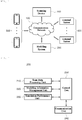
- FIG. 1 schematically shows the configuration of an entire system for providing information on modeling of a structure according to one embodiment of the invention.
- the entire system may comprise a communication network 100, a modeling system 200, a scanning device 300, an external server 400, and a user terminal device 500.
- the communication network 100 may be implemented with a communication scheme encompassing both wired and wireless communications, and may be implemented as a communication network including a mobile communication network. More specifically, the communication network 100 described herein should be understood as encompassing, for example, commonly known WLAN (Wireless LAN), CDMA (Code Division Multiple Access), WCDMA (Wideband Code Division Multiple Access), GSM (Global System for Mobile communications), or LTE (Long Term Evolution) communication networks.
- WLAN Wireless LAN
- CDMA Code Division Multiple Access
- WCDMA Wideband Code Division Multiple Access
- GSM Global System for Mobile communications
- LTE Long Term Evolution
- the modeling system 200 may function to accurately and efficiently construct information on modeling of an existing structure, by acquiring three-dimensional exterior scan data for an exterior of a structure and three-dimensional interior scan data for an interior of the structure; matching the three-dimensional exterior scan data and the three-dimensional interior scan data, with respect to at least one feature point (e.g., an opening such as a door and a window) common to the three-dimensional exterior scan data and the three-dimensional interior scan data; and generating information on modeling of the structure with reference to a state of the matching between the three-dimensional exterior scan data and the three-dimensional interior scan data.
- a feature point e.g., an opening such as a door and a window
- the scanning device 300 may function to generate three-dimensional scan data for the exterior or interior of the structure, and an unmanned aerial vehicle (UAV) having a photographing means, a LADAR (laser radar) scanner, or the like may be adopted as the scanning device 300 according to the invention.
- UAV unmanned aerial vehicle
- LADAR laser radar
- a photographing device usually used by a general user e.g., a portable camera or a camera provided in a smart phone
- the scanning device 300 may function to provide the modeling system 200 with information on locations where the three-dimensional scan data are generated.
- the external server 400 may encompass various servers capable of providing the modeling system 200 with various information that may be referred to in generating (i.e., estimating) the information on modeling of the structure (e.g., information on specifications of the structure or components thereof, relevant regulations, and the like).
- the user terminal device 500 is digital equipment capable of connecting to and then communicating with the communication network 100, and any type of portable digital equipment having a memory means and a microprocessor for computing capabilities, such as a smart phone, tablet, desktop computer, and notebook computer, may be adopted as the user terminal device 500 according to the invention.
- the user terminal device 500 according to one embodiment of the invention may include a necessary program, such as an application, web browser, and widget, for assisting a user to provide three-dimensional scan data to the modeling system 200 or to receive information on modeling of a structure or information on a simulation performance result from the modeling system 200.
- FIG. 2 illustratively shows the internal configuration of the modeling system according to one embodiment of the invention.
- the modeling system 200 may comprise a scan data processing unit 210, a modeling information management unit 220, a simulation performance unit 230, a communication unit 240, and a control unit 250.
- the scan data processing unit 210, the modeling information management unit 220, the simulation performance unit 230, the communication unit 240, and the control unit 250 may be program modules to communicate with an external system (not shown).
- the program modules may be included in the modeling system 200 in the form of operating systems, application program modules, and other program modules, while they may be physically stored in a variety of commonly known storage devices. Further, the program modules may also be stored in a remote storage device that may communicate with the modeling system 200. Meanwhile, such program modules may include, but not limited to, routines, subroutines, programs, objects, components, data structures, and the like for performing specific tasks or executing specific abstract data types as will be described below in accordance with the invention.
- the scan data processing unit 210 may function to acquire three-dimensional exterior scan data for an exterior of a structure to be modeled and three-dimensional interior scan data for an interior of the structure, respectively.
- the three-dimensional scan data for the interior of the structure may be acquired by merging a plurality of partial scan data generated as a result of photographing or scanning the interior of the structure at each of a plurality of points in an interior space of the structure.
- the three-dimensional scan data for the exterior of the structure may be acquired by merging a plurality of partial scan data generated as a result of photographing or scanning the exterior of the structure at each of a plurality of points in an exterior space of the structure.
- the plurality of partial scan data generated as above may include additional data on locations where the corresponding partial scan data are generated, respectively.
- the scan data processing unit 210 or another component communicating with the scan data processing unit 210 may merge the plurality of partial scan data with reference to the above additional data on the locations, thereby generating the three-dimensional exterior scan data or three-dimensional interior scan data in a single piece.
- the above partial scan data may be generated by a photographing means or scanning means provided in an UAV that may be freely located at any point in a three-dimensional space.
- FIGS. 3A and 3B illustratively show scan data collected as a result of photographing a structure according to one embodiment of the invention.
- partial scan data may be acquired as a result of photographing an exterior of a structure to be modeled by a photographing means provided in an unmanned aerial vehicle floating in the air (see FIG. 3A ), and the partial scan data may include additional data on locations (i.e., latitudes, longitudes, and altitudes) where the corresponding partial scan data are generated (see FIG. 3B ) .
- the modeling information management unit 220 may function to match the three-dimensional exterior scan data and the three-dimensional interior scan data, with respect to at least one feature point common to the three-dimensional exterior scan data and the three-dimensional interior scan data.
- the feature point may include an opening such as a door, a window, and a passage entrance or exit.
- the feature point described herein is not necessarily limited to the foregoing, and it is noted that any feature point found in common between the three-dimensional exterior scan data and three-dimensional interior scan data of the structure may be utilized as the feature point with respect to which the matching according to the invention is performed.
- the modeling information management unit 220 may recognize shapes of feature points (e.g., border shapes of doors or windows) appearing in the three-dimensional exterior scan data, and shapes of feature points appearing in the three-dimensional interior scan data, respectively, and may find at least one feature point common to the three-dimensional exterior scan data and the three-dimensional interior scan data, with reference to the recognized shapes of the feature points.
- shape of feature points e.g., border shapes of doors or windows
- shape of feature points appearing in the three-dimensional interior scan data respectively, and may find at least one feature point common to the three-dimensional exterior scan data and the three-dimensional interior scan data, with reference to the recognized shapes of the feature points.
- the three-dimensional exterior scan data and three-dimensional interior scan data separately generated from the exterior and interior of the structure may be integrated into one piece of unified scan data, and consequently, the complete scan data for the entire structure including both the exterior and interior may be obtained.
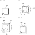
- FIGS. 4A to 4D illustratively show the configuration for matching scan data according to one embodiment of the invention.
- three-dimensional interior scan data 410 obtained as a result of photographing or scanning an interior of a structure 401 to be modeled may be matched (or aligned) with three-dimensional exterior scan data 420 obtained as a result of photographing or scanning an exterior of the structure 401, with respect to their common openings, i.e., a door 431 and a window 432.
- the three-dimensional interior scan data include first area scan data for a first area inside the structure, and second area scan data for a second area inside the structure (which is distinguished from the first area).
- the first area scan data may be acquired by merging a plurality of partial scan data generated as a result of photographing or scanning at each of a plurality of points in the first area inside the structure
- the second area scan data may be acquired by merging a plurality of partial scan data generated as a result of photographing or scanning at each of a plurality of points in the second area inside the structure.
- the scan data processing unit 210 may function to match the first area scan data and the second area scan data with respect to at least one feature point common to the first area scan data and the second area scan data, thereby completing the three-dimensional interior scan data for the structure.
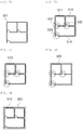
- FIGS. 5A to 5E illustratively show the configuration for matching scan data according to one embodiment of the invention.
- first area scan data 511, second area scan data 512, and third area scan data 513 which are obtained as a result of photographing or scanning each of first, second, and third areas disposed horizontally in an interior space of a structure 501 to be modeled, may be matched and merged with respect to their common openings, i.e., doors 531 and 532, and consequently, three-dimensional interior scan data 510 for the entire interior space of the structure 501 may be generated.
- the three-dimensional interior scan data 510 generated for the interior of the structure 501 to be modeled may be matched (or aligned) with three-dimensional exterior scan data 520 obtained as a result of photographing or scanning an exterior of the structure 501, with respect to their common opening, i.e., a door 533.
- FIG. 6 illustratively shows the configuration for matching scan data according to one embodiment of the invention.
- first area scan data 611 and second area scan data 612 which are obtained as a result of photographing or scanning each of first and second areas disposed vertically in an interior space of a structure 601 to be modeled, may be matched and merged with respect to their common openings, i.e., doors 631 and 633 and windows 632 and 634, and consequently, three-dimensional interior scan data for the entire interior space of the structure 601 may be generated.
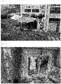
- FIGS. 7 to 9 illustratively show images of three-dimensional exterior scan data and three-dimensional interior scan data that may be matched with respect to feature points according to one embodiment of the invention.
- an opening such as a window serving as a matching reference may be recognized in three-dimensional exterior scan data generated as a result of photographing or scanning an exterior of a structure to be modeled.
- three-dimensional exterior scan data and three-dimensional interior scan data for a structure to be modeled may be matched with respect to a first-floor window (see cross-shaped icons in FIGS. 8 and 9 ), which is a feature point recognized in both the three-dimensional exterior scan data and three-dimensional interior scan data for the structure.
- the modeling information management unit 220 may function to generate (i.e., estimate) information on modeling of the structure with reference to a state of the matching between the three-dimensional exterior scan data and the three-dimensional interior scan data.
- the information on modeling of the structure may include BIM (Building Information Modeling) information of the structure.
- the modeling information management unit 220 may generate the information on modeling of the structure with further reference to context information on the structure.
- the context information may include information on a type of the structure, a location of the structure, locations where the three-dimensional exterior scan data or the three-dimensional interior scan data are generated, and relevant regulations for the structure.
- the context information according to the invention is not necessarily limited to the foregoing, and it is noted that any information that may be referred to in generating the information on modeling of the structure may be utilized as the context information, as long as the objects of the invention may be achieved.
- modeling information on a thickness of insulation in outer walls of a building to be modeled is generated.
- the modeling information management unit 220 may recognize that a thickness of the outer walls of the building is 200 mm, with reference to a state of the matching between three-dimensional interior scan data and three-dimensional exterior scan data for the building. Moreover, with further reference to context information on a location where the scan data for the building have been generated (i.e., a location of the building), specifications of energy-saving design standards according to the location of the building, and the like, the modeling information management unit 220 according to one embodiment of the invention may estimate a thickness of the insulation in the 200-mm thick outer walls of the building, which is located at a latitude of 37 degrees 15 minutes 21.263 seconds and a longitude of 127 degrees 16 minutes 39.977 seconds east, in view of the specifications.
- the simulation performance unit 230 may function to perform various simulations for a safety inspection or energy efficiency qualification of the structure and to provide results thereof, using the modeling information on the structure generated by the modeling information management unit 220.
- the simulation performance unit 230 may process the modeling information on the structure generated by the modeling information management unit 220 to conform to a known format such as gbXML (Green Building XML), in order to perform a simulation for the structure.
- gbXML Green Building XML
- the communication unit 240 may function to enable the modeling system 200 to communicate with an external device.
- control unit 250 may function to control data flow among the scan data processing unit 210, the modeling information management unit 220, the simulation performance unit 230, and the communication unit 240. That is, the control unit 250 may control inbound data flow or data flow among the respective components of the modeling system, such that the scan data processing unit 210, the modeling information management unit 220, the simulation performance unit 230, and the communication unit 240 may carry out their particular functions, respectively.
- the embodiments according to the invention as described above may be implemented in the form of program instructions that can be executed by various computer components, and may be stored on a computer-readable recording medium.
- the computer-readable recording medium may include program instructions, data files, data structures and the like, separately or in combination.
- the program instructions stored on the computer-readable recording medium may be specially designed and configured for the present invention, or may also be known and available to those skilled in the computer software field.
- Examples of the computer-readable recording medium include the following: magnetic media such as hard disks, floppy disks and magnetic tapes; optical media such as compact disk-read only memory (CD-ROM) and digital versatile disks (DVDs); magneto-optical media such as floptical disks; and hardware devices such as read-only memory (ROM), random access memory (RAM) and flash memory, which are specially configured to store and execute program instructions.
- Examples of the program instructions include not only machine language codes created by a compiler or the like, but also high-level language codes that can be executed by a computer using an interpreter or the like.
- the above hardware devices may be configured to operate as one or more software modules to perform the processes of the present invention, and vice versa.
Landscapes
- Engineering & Computer Science (AREA)
- Physics & Mathematics (AREA)
- Geometry (AREA)
- General Physics & Mathematics (AREA)
- Theoretical Computer Science (AREA)
- Computer Hardware Design (AREA)
- Software Systems (AREA)
- Computer Graphics (AREA)
- Architecture (AREA)
- Mathematical Analysis (AREA)
- Mathematical Optimization (AREA)
- Pure & Applied Mathematics (AREA)
- Evolutionary Computation (AREA)
- General Engineering & Computer Science (AREA)
- Computational Mathematics (AREA)
- Structural Engineering (AREA)
- Civil Engineering (AREA)
- Remote Sensing (AREA)
- Human Computer Interaction (AREA)
- Computer Vision & Pattern Recognition (AREA)
- Processing Or Creating Images (AREA)
- Management, Administration, Business Operations System, And Electronic Commerce (AREA)
Applications Claiming Priority (2)
| Application Number | Priority Date | Filing Date | Title |
|---|---|---|---|
| KR1020150136353A KR101624670B1 (ko) | 2015-09-25 | 2015-09-25 | 구조물의 모델링에 관한 정보를 제공하기 위한 방법, 시스템 및 컴퓨터 판독 가능한 기록 매체 |
| PCT/KR2015/011897 WO2017051977A1 (fr) | 2015-09-25 | 2015-11-06 | Procédé, système et support d'enregistrement lisible par ordinateur permettant de fournir des informations sur une modélisation de structure |
Publications (2)
| Publication Number | Publication Date |
|---|---|
| EP3355276A1 true EP3355276A1 (fr) | 2018-08-01 |
| EP3355276A4 EP3355276A4 (fr) | 2019-05-08 |
Family
ID=56104874
Family Applications (1)
| Application Number | Title | Priority Date | Filing Date |
|---|---|---|---|
| EP15904788.5A Withdrawn EP3355276A4 (fr) | 2015-09-25 | 2015-11-06 | Procédé, système et support d'enregistrement lisible par ordinateur permettant de fournir des informations sur une modélisation de structure |
Country Status (6)
| Country | Link |
|---|---|
| US (1) | US20180232948A1 (fr) |
| EP (1) | EP3355276A4 (fr) |
| JP (1) | JP6649542B2 (fr) |
| KR (1) | KR101624670B1 (fr) |
| CN (1) | CN108292445A (fr) |
| WO (1) | WO2017051977A1 (fr) |
Families Citing this family (14)
| Publication number | Priority date | Publication date | Assignee | Title |
|---|---|---|---|---|
| CN106524940B (zh) * | 2016-11-30 | 2022-09-27 | 华中科技大学 | 一种盾构法隧道智能ct检测诊断系统及方法 |
| US12361511B2 (en) | 2018-02-09 | 2025-07-15 | Matterport, Inc. | Accuracy of GPS coordinates associated with image capture locations |
| CN109446583A (zh) * | 2018-09-29 | 2019-03-08 | 鼎宸建设管理有限公司 | 基于bim技术的绿色建筑设计方法 |
| US10936902B1 (en) | 2018-11-27 | 2021-03-02 | Zoox, Inc. | Training bounding box selection |
| US11010907B1 (en) * | 2018-11-27 | 2021-05-18 | Zoox, Inc. | Bounding box selection |
| CN109903382B (zh) * | 2019-03-20 | 2023-05-23 | 中煤航测遥感集团有限公司 | 点云数据的融合方法及装置 |
| CN110909399A (zh) * | 2019-10-16 | 2020-03-24 | 黄晓峰 | 一种钢结构虚拟预拼装方法 |
| CN110714416A (zh) * | 2019-10-25 | 2020-01-21 | 中国一冶集团有限公司 | 一种基于bim的大悬臂梁桥梁体临时固结施工结构和方法 |
| US11263818B2 (en) * | 2020-02-24 | 2022-03-01 | Palo Alto Research Center Incorporated | Augmented reality system using visual object recognition and stored geometry to create and render virtual objects |
| CN111597666B (zh) * | 2020-05-20 | 2021-01-26 | 佛山电力设计院有限公司 | 一种将bim应用到变电站建设过程的方法 |
| CN112906094A (zh) * | 2020-10-30 | 2021-06-04 | 上海市政工程设计研究总院(集团)有限公司 | 基于信息化的桥梁维修改建方法和系统 |
| CN113593014A (zh) * | 2021-07-23 | 2021-11-02 | 浙江原心网络科技有限公司 | 一种基于多轴飞行器在未知空间内三维扫描建模系统 |
| CN113781634A (zh) * | 2021-09-10 | 2021-12-10 | 太仓博德房车科技有限公司 | 一种三维数据化1比1车辆扫描系统及其工作方法 |
| JP2023135025A (ja) * | 2022-03-15 | 2023-09-28 | 株式会社Lixil | 支援装置、端末装置、及び支援プログラム |
Family Cites Families (8)
| Publication number | Priority date | Publication date | Assignee | Title |
|---|---|---|---|---|
| JP3734167B2 (ja) * | 2002-07-10 | 2006-01-11 | マツダ株式会社 | 企画支援プログラム、方法、装置並びに記録媒体 |
| KR100569629B1 (ko) * | 2005-11-30 | 2006-04-10 | 주식회사 한국지오매틱스 | 골프코스 공략도 제작방법 |
| JP2009134390A (ja) * | 2007-11-29 | 2009-06-18 | Yutaka Miyamoto | 構造物シミュレーションシステム及びサーバ装置 |
| CN102651145B (zh) * | 2012-04-06 | 2014-11-05 | 哈尔滨工业大学 | 股骨三维模型可视化方法 |
| AU2013203521B2 (en) * | 2012-08-13 | 2016-05-26 | Auto-Measure Pty Limited | Building modelling system |
| KR101525891B1 (ko) * | 2013-02-13 | 2015-06-03 | (주)다인디지컬처 | 3차원 실내공간 정보 구축을 위한 라이다 데이터 모델링 방법 및 시스템 |
| US9811714B2 (en) * | 2013-08-28 | 2017-11-07 | Autodesk, Inc. | Building datum extraction from laser scanning data |
| CN104142311B (zh) * | 2014-08-15 | 2016-10-05 | 华南农业大学 | 一种用近红外光谱技术预测火炬松松脂产量的方法 |
-
2015
- 2015-09-25 KR KR1020150136353A patent/KR101624670B1/ko active Active
- 2015-11-06 JP JP2018535796A patent/JP6649542B2/ja not_active Expired - Fee Related
- 2015-11-06 WO PCT/KR2015/011897 patent/WO2017051977A1/fr not_active Ceased
- 2015-11-06 CN CN201580084741.5A patent/CN108292445A/zh active Pending
- 2015-11-06 EP EP15904788.5A patent/EP3355276A4/fr not_active Withdrawn
-
2018
- 2018-03-26 US US15/935,110 patent/US20180232948A1/en not_active Abandoned
Also Published As
| Publication number | Publication date |
|---|---|
| JP6649542B2 (ja) | 2020-02-19 |
| JP2018537796A (ja) | 2018-12-20 |
| US20180232948A1 (en) | 2018-08-16 |
| WO2017051977A1 (fr) | 2017-03-30 |
| KR101624670B1 (ko) | 2016-05-26 |
| EP3355276A4 (fr) | 2019-05-08 |
| CN108292445A (zh) | 2018-07-17 |
Similar Documents
| Publication | Publication Date | Title |
|---|---|---|
| US20180232948A1 (en) | Method, system and computer readable recording medium for providing information on modeling of structure | |
| Molina et al. | A multimodal fingerprint-based indoor positioning system for airports | |
| Han et al. | Geometry-and appearance-based reasoning of construction progress monitoring | |
| EP2959267B1 (fr) | Positionnement d'un dispositif mobile | |
| US20200100066A1 (en) | System and Method for Generating Floor Plans Using User Device Sensors | |
| CN106767819B (zh) | 一种基于bim的室内导航数据构建方法及导航系统 | |
| CN114972668B (zh) | 基于高度信息的激光slam方法和系统 | |
| US9285227B1 (en) | Creating routing paths in maps | |
| US11087035B2 (en) | System and method for detection and simulation of building models | |
| EP3674661B1 (fr) | Procédé et dispositif de localisation, support d'enregistrement et dispositif électronique | |
| US12026434B2 (en) | Method and apparatus for providing an updated digital building model | |
| EP4220087B1 (fr) | Procédé et système d'étalonnage d'un espace dans une zone intérieure | |
| KR101688746B1 (ko) | 구조물의 리모델링을 지원하기 위한 방법, 시스템 및 컴퓨터 판독 가능한 기록 매체 | |
| Kim et al. | Data management framework of drone-based 3D model reconstruction of disaster site | |
| Hamledari et al. | UAV mission planning using swarm intelligence and 4D BIMs in support of vision-based construction progress monitoring and as-built modeling | |
| KR102525764B1 (ko) | 항공 촬영방향을 고려한 이미지 모델 정렬 장치 및 방법 | |
| Ibrahim et al. | Model-driven visual data capture on construction sites: Method and metrics of success | |
| EP4437445A1 (fr) | Système, procédé et programme informatique pour surveillance de progression de construction | |
| KR102562031B1 (ko) | 차선 정보를 이용한 자율주행 차량의 측위 방법, 장치 및 컴퓨터프로그램 | |
| CN115793715B (zh) | 一种无人机辅助飞行方法、系统、装置及存储介质 | |
| JP6857696B2 (ja) | 決定装置、プログラム、システム、及び決定方法 | |
| Zeibak-Shini et al. | Mapping the structural frame of a damaged reinforced concrete building using as-damaged scans and as-built BIM | |
| CN115169679B (en) | Automatic planning method, device and equipment for indoor point cloud data acquisition site of building | |
| JP7644297B1 (ja) | 情報処理システム及びプログラム | |
| CN115209525B (zh) | 一种锚点规划方法 |
Legal Events
| Date | Code | Title | Description |
|---|---|---|---|
| STAA | Information on the status of an ep patent application or granted ep patent |
Free format text: STATUS: THE INTERNATIONAL PUBLICATION HAS BEEN MADE |
|
| PUAI | Public reference made under article 153(3) epc to a published international application that has entered the european phase |
Free format text: ORIGINAL CODE: 0009012 |
|
| STAA | Information on the status of an ep patent application or granted ep patent |
Free format text: STATUS: REQUEST FOR EXAMINATION WAS MADE |
|
| 17P | Request for examination filed |
Effective date: 20180419 |
|
| AK | Designated contracting states |
Kind code of ref document: A1 Designated state(s): AL AT BE BG CH CY CZ DE DK EE ES FI FR GB GR HR HU IE IS IT LI LT LU LV MC MK MT NL NO PL PT RO RS SE SI SK SM TR |
|
| AX | Request for extension of the european patent |
Extension state: BA ME |
|
| RIN1 | Information on inventor provided before grant (corrected) |
Inventor name: KIM, SANG HOON Inventor name: HONG, JUN PYO Inventor name: AHN, KIL JAE |
|
| DAV | Request for validation of the european patent (deleted) | ||
| DAX | Request for extension of the european patent (deleted) | ||
| A4 | Supplementary search report drawn up and despatched |
Effective date: 20190408 |
|
| RIC1 | Information provided on ipc code assigned before grant |
Ipc: G06T 17/00 20060101AFI20190402BHEP |
|
| RAP1 | Party data changed (applicant data changed or rights of an application transferred) |
Owner name: DONGWOO ENGINEERING & CONSTRUCTION CO., LTD. Owner name: HONG, JUN PYO Owner name: KIM, SANG HOON |
|
| STAA | Information on the status of an ep patent application or granted ep patent |
Free format text: STATUS: THE APPLICATION IS DEEMED TO BE WITHDRAWN |
|
| 18D | Application deemed to be withdrawn |
Effective date: 20210601 |