EP3376160A1 - Verfahren und system zur identifizierung von städtischen objekten - Google Patents
Verfahren und system zur identifizierung von städtischen objekten Download PDFInfo
- Publication number
- EP3376160A1 EP3376160A1 EP16864660.2A EP16864660A EP3376160A1 EP 3376160 A1 EP3376160 A1 EP 3376160A1 EP 16864660 A EP16864660 A EP 16864660A EP 3376160 A1 EP3376160 A1 EP 3376160A1
- Authority
- EP
- European Patent Office
- Prior art keywords
- objects
- data
- urban
- points
- laser scanning
- Prior art date
- Legal status (The legal status is an assumption and is not a legal conclusion. Google has not performed a legal analysis and makes no representation as to the accuracy of the status listed.)
- Ceased
Links
Images


Classifications
-
- G—PHYSICS
- G01—MEASURING; TESTING
- G01C—MEASURING DISTANCES, LEVELS OR BEARINGS; SURVEYING; NAVIGATION; GYROSCOPIC INSTRUMENTS; PHOTOGRAMMETRY OR VIDEOGRAMMETRY
- G01C11/00—Photogrammetry or videogrammetry, e.g. stereogrammetry; Photographic surveying
- G01C11/04—Interpretation of pictures
-
- G—PHYSICS
- G06—COMPUTING OR CALCULATING; COUNTING
- G06T—IMAGE DATA PROCESSING OR GENERATION, IN GENERAL
- G06T17/00—Three-dimensional [3D] modelling for computer graphics
-
- G—PHYSICS
- G01—MEASURING; TESTING
- G01S—RADIO DIRECTION-FINDING; RADIO NAVIGATION; DETERMINING DISTANCE OR VELOCITY BY USE OF RADIO WAVES; LOCATING OR PRESENCE-DETECTING BY USE OF THE REFLECTION OR RERADIATION OF RADIO WAVES; ANALOGOUS ARRANGEMENTS USING OTHER WAVES
- G01S17/00—Systems using the reflection or reradiation of electromagnetic waves other than radio waves, e.g. lidar systems
- G01S17/88—Lidar systems specially adapted for specific applications
- G01S17/89—Lidar systems specially adapted for specific applications for mapping or imaging
-
- G—PHYSICS
- G06—COMPUTING OR CALCULATING; COUNTING
- G06F—ELECTRIC DIGITAL DATA PROCESSING
- G06F18/00—Pattern recognition
-
- G—PHYSICS
- G06—COMPUTING OR CALCULATING; COUNTING
- G06T—IMAGE DATA PROCESSING OR GENERATION, IN GENERAL
- G06T17/00—Three-dimensional [3D] modelling for computer graphics
- G06T17/05—Geographic models
-
- G—PHYSICS
- G06—COMPUTING OR CALCULATING; COUNTING
- G06V—IMAGE OR VIDEO RECOGNITION OR UNDERSTANDING
- G06V20/00—Scenes; Scene-specific elements
- G06V20/10—Terrestrial scenes
- G06V20/176—Urban or other man-made structures
-
- G—PHYSICS
- G06—COMPUTING OR CALCULATING; COUNTING
- G06V—IMAGE OR VIDEO RECOGNITION OR UNDERSTANDING
- G06V20/00—Scenes; Scene-specific elements
- G06V20/20—Scenes; Scene-specific elements in augmented reality scenes
-
- G—PHYSICS
- G06—COMPUTING OR CALCULATING; COUNTING
- G06V—IMAGE OR VIDEO RECOGNITION OR UNDERSTANDING
- G06V20/00—Scenes; Scene-specific elements
- G06V20/60—Type of objects
- G06V20/64—Three-dimensional [3D] objects
-
- G—PHYSICS
- G01—MEASURING; TESTING
- G01C—MEASURING DISTANCES, LEVELS OR BEARINGS; SURVEYING; NAVIGATION; GYROSCOPIC INSTRUMENTS; PHOTOGRAMMETRY OR VIDEOGRAMMETRY
- G01C11/00—Photogrammetry or videogrammetry, e.g. stereogrammetry; Photographic surveying
- G01C11/04—Interpretation of pictures
- G01C11/06—Interpretation of pictures by comparison of two or more pictures of the same area
- G01C11/28—Special adaptation for recording picture point data, e.g. for profiles
-
- G—PHYSICS
- G06—COMPUTING OR CALCULATING; COUNTING
- G06F—ELECTRIC DIGITAL DATA PROCESSING
- G06F30/00—Computer-aided design [CAD]
-
- G—PHYSICS
- G06—COMPUTING OR CALCULATING; COUNTING
- G06T—IMAGE DATA PROCESSING OR GENERATION, IN GENERAL
- G06T17/00—Three-dimensional [3D] modelling for computer graphics
- G06T17/10—Constructive solid geometry [CSG] using solid primitives, e.g. cylinders, cubes
Definitions
- the proposed solution relates to the methods of processing information, in particular to a method and system of processing data from different sources (ground-based laser scanning and photo panoramas, aerial and space imagery, cartographic data, semantic information etc.), for subsequent recognition on certain types of urban objects, determining its coordinates and characteristics, the selection of the texture of objects and the subsequent export of the received information to various GIS and CAD-systems for further display of urban objects in the form of a three-dimensional urban models.
- sources ground-based laser scanning and photo panoramas, aerial and space imagery, cartographic data, semantic information etc.
- the known method is limited to the type of objects recognized, and it does not have sufficient accuracy.
- the objective of the claimed solution is to create a method and system of recognition of different types of urban objects represented on a different type of data, in particular photographic images and laser scanning data.
- the technical result is to improve the accuracy of the recognition of urban objects in the construction of urban panorama models based on laser scanning data and photographic data.
- One of the preferred implementation of the claimed invention is a computer-implemented method for recognizing of urban facilities, which includes processing of primary data, that contains at least photographic data and laser scanning data about urban objects.
- the method includes the following stages:
- the primary data contains additionally spatial geodata and/or semantic data and/or panoramic images.
- photographic data are the data obtained from using mobile scanning and/or aerial and/or cosmic photography.
- the semantic data contains metadata of urban objects.
- the original data are checked for quality of presentation of information at a very beginning.
- laser data processing in a stage of primary data processing, includes deleting of points from point clouds that corresponds to the points formed due to interference in the laser scanning process, non-stationary objects, or points that are absent on the two or more laser scans of the same place.
- testing of ground and air panoramas on the subject of image quality of recognized objects is performed.
- the localization of aerospace- and land photographs, as well as point clouds is carried out, for the detection of objects and determination of the order of their processing.
- the normals of cloud points for each cloud point the nearest neighboring points are determined.
- the planes are constructed by the RANSAC method.
- the normal to point is the normal vector of the plane that passes through the largest number of neighbors.
- the points of the cloud are divided according to the planar grid, in each cell of which for each point and its corresponding normal neighboring points belonging to the plane described by this pair are sought.
- the point with the maximum number of neighboring points along the plane are taken as the basis for the plane, with all the neighboring points are withdrawn from further processing.
- all of the planes in one cell are checked for compatibility with planes of neighboring cells and if the test is successful, then the planes of neighboring points mentioned above are combined.
- the distance L between the planes is verified and if the planes are located at a distance not exceeding L, then they are combined.
- the order of searching for object types is established by the search policy algorithm.
- the recognition of urban objects are carried out on the basis of characteristic features established for each type of object.
- the recognition of urban objects are carried out on the basis of a comparison of the identified objects from the processed data with reference objects from the database.
- system of recognition of urban objects containing one or more processors and at least one memory storing machine-readable commands, which, when executed, at least, one processing unit performs processing of primary data containing, at least photographic data and laser scanning data, using the above-mentioned method for recognition of urban objects.
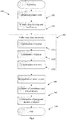
- Fig. 1 shows a general scheme for performing the steps of the proposed method of recognition of urban objects (100).
- Urban objects are understood to be human made objects of the same type most common in the urban landscape: buildings and structures, fences, poles, traffic signs and traffic lights, public transport stops, advertising media, etc.
- primary data is received, representing at least photographic data and laser scanning data.
- Mobile scanning survey of urban areas is produced by a special software and hardware complex, installed on the top of the car which includes high-resolution panoramic cameras, laser scanners (range finders), devices for precision positioning of a car and control computer with a special software.
- the primary data are point clouds in *las* format (WGS84 coordinate system), panoramic photos jpg, the coordinates of the panoramas and the data from the GNSS base station.
- Also for terrestrial shooting can be used "stereopair", two panoramic cameras, fixed to a small distance from each other and removing simultaneously.
- GeoTIFF GeoTIFF format
- Spatial data (geodata) for recognition are presented by vector layers in Shapefile format containing coordinates (system of coordinates WGS84 projection Web Mercator): boundaries of buildings, roads, and other objects.
- coordinates system of coordinates WGS84 projection Web Mercator
- a variety of semantic related information can be also used for that purposes - the metadata by which the number of stores can appear, floor plans of buildings, etc.
- step 102 the received primary data is verified and cleaned, vector and raster data is loaded into the geodatabase (GDB) and validation of the data is preformed (correctness of formats, absence of inconsistent data, completeness of information, etc.).
- GDB geodatabase
- Processing point clouds in particular removing "garbage” points caused by noise during shooting, removal of moving objects that are absent on different passes.
- the testing of ground and air panoramas for the processing abilities and quality of the information provided, for example, absence of clouds interfering with the restoration of the terrain and roofs, and localization of sites for the detection of objects and the definition of their order of processing, which determines the areas for processing that can be manually set or calculated automatically based on availability of the data.
- step 103 preprocessing of processed and cleaned laser scanning data is performed.
- step 103 five sub-steps are performed - 1031-1033.
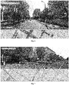
- Fig. 2-3 shows an example of the work of the method in constructing normals to the points of the laser scanning cloud.
- Step 3 On the sub-step #1031 of preparation of data definition and construction of normal 110 to each of the points of cloud 130 is performed ( Figure 3 ), the union of points into the plane and building a relief on the basis of aerial photography.
- To determine the normal 110 and laser point planes are grouped by location and time of shooting. Further, for each point 130 nearest neighbors are taken and are constructed planes by the RANSAC method. The normal vector of the plane that passes through the largest number of neighbors, is considered normal to a given point.
- the construction of planes for sets of cloud points 130 is performed.
- cloud points 130 are distributed over a planar grid. In each cell of this grid, for each point and its corresponding normal are searched for neighboring points, belonging to the plane described by this pair. Point 130 with the maximum number of neighboring points 130 along the plane, is taken as the basis for the plane, and all the neighboring points are removed from further processing, after which the process is repeated.
- neighboring points along the plane are meant the points of cloud 130 that lie in a plane containing the current point 130 and perpendicular to its normal 110. After all the planes are found, an attempt is made to combine these planes with planes from neighboring cells. Planes are combined only if the distance L between them is not greater than the specified values, for example, 30 centimeters. This principle allows us to separate buildings among themselves standing on one line.
- the terrain is constructed using photogrammetric algorithms based on images obtained during aerial survey. Additionally, in the above-mentioned sub-step 1033, construction of reliefs of individual objects, for example, parts of buildings (roof, facade, etc.) can be done.
- a serial recognition of static urban objects from a set of cleaned data form laser scanning and photographic survey is performed, in which the urban objects (step 104) are defined.
- Objects of different types are searched in processed raw data in series, while those sets points in the clouds or areas of images that have been correlated with any object, are marked and do not participate in further processing.
- detection scripts are executed in the following order: buildings and structures, fences, posts, billboards, signs and traffic lights, bus stops, other objects. The sequence can be changed manually or automatically in order to achieve the best recognition results. Also separate parts of the process can be deleted or separate, for example, you can configure script to skip a specific type of objects (poles, billboards, fences and etc.).
- Each recognition script has default settings, in compliance with which the platform carries out automatic recognition. There is also the ability to create a configuration template for each search algorithm, which can then be used for default.
- Fig. 4-5 for recognizing the building on the base of cartographic and semantic data the outline of the building and, perhaps its approximate height are defined.
- An array is allocated from the points cloud, which belongs to the searched object, and from the aerial survey - the necessary textures.
- an intelligent system of combination is used, which allows you to "pull" the necessary parts of the data even with a shift of several meters.
- the selected information is checked for a number of key characteristics, identifying the object as a building.
- Such signs are: the presence of extended vertical flat surfaces along the boundaries of an object, the presence of window depressions in point clouds, the height of the object above surrounding terrain, the presence of a characteristic roof on the survey data from the air and some others.
- Fencing is defined as an extended plane adjacent to land with the height of no more than a given limit.
- additional features can be used: the absence in the area of space of contours of houses, as well as other adjacent objects, no additional relief on the plane, uniform average texture color, etc.
- Fig. 5 shows an example of poles recognition. In general the principle consists of three stages.
- the points are distributed into a grid of square meters. For points of each square and its neighbors several times randomly three adjacent points are selected and a cylinder is constructed through these points. If in the grid element the centers of such cylinders lie in the same plane coordinate, this place is marked as vertically oriented cylinder. For each such place, characteristics for algorithm of training are constructed, namely:
- the adaptive boosting algorithm (ADABOOST) characteristics of objects and classification are provided.
- the algorithm builds a cascade of recognition. In our case, two separate cascades are constructed: the first is rough, screening out 95% of objects. The second is more precise, it sifts out still about 99%. This approach is used for further correction of errors - if using this algorithm a missed object is found, it is most likely to be among the objects of the first cascade. This reduces the number of viewed objects in general, without reducing the accuracy of object detection.
- the recognition of traffic signs takes place in the optical range.
- As an auxiliary source data specially prepared database is used with a lot of real images of signs on terrain.
- the algorithm consists of constructing the characteristic features of the image and learning the adaptive boost cascade on examples from the existing base of signs. To eliminate errors of the second kind secondary characteristics in point clouds are monitored: linear dimensions, distance from roadway, installation height, etc.
- Traffic lights are simultaneously detected in a point cloud and at photo panorama. Column of certain parameters with a characteristic of "box" of a traffic light in the point cloud are detected. In optical photography there is a search for circles with given colors. To cut off erroneous objects cartographic data about the carriageway parts and intersections are used.
- a billboard is defined as a plane located on a certain height with certain linear dimensions. To avoid Type II errors all object-applicants are checked also for the absence of other objects located near by, especially fences and buildings. Also secondary signs are checked, for example, the presence of a column as a supports, the presence of advertising textures with sharp drops of medium color ( Fig. 7 ).
- Public transport stop is detected by availability of perpendicular planes of a certain size, the horizontal plane of the characteristic texture visible from above, as well as the presence additional features: the presence of a "sign" object of a certain type and a broken yellow strip in the optical image. Also distance from the roadway and a number of other factors are monitored.
- method 100 there is an opportunity of recognition of other objects not initially inherent in the process of recognition.
- method 100 has the possibility of learning with a help of using real-image library analysis, and assigning several geometric parameters characterizing the dimensions and the position of objects.
- the training module is built on an iterative scheme and allows to learn algorithms, indicating Type I and Type II errors for each stage of recognition process.
- step 105 for each detected object, at least geographical coordinates in WGS84 (longitude, latitude and height) and linear dimensions are identified. Additionally, the following parameters can be determined:
- step 106 the construction of polygonal models of found objects is carried out, containing textures in a graphic format, for example jpg, received from photographs.
- a graphic format for example jpg
- the resulting spatial data can be exported to geographic files of vector formats such as SHAPEFILE, KML or GeoJSON for presentation in various GIS, into three-dimensional models in 3D formats or OBJ for use in CAD-systems, etc.
- vector formats such as SHAPEFILE, KML or GeoJSON for presentation in various GIS, into three-dimensional models in 3D formats or OBJ for use in CAD-systems, etc.
- Fig. 8 represents a perspective view of a system 200 implementing steps of the above-mentioned urban object recognition method 100.
- System 200 is executed on the basis of a computer, for example, 1MB PC and contains, at least, such tools as: processor 210, memory 220, interfaces I / O 230 and I / O device 240 combined with a common data bus 250.
- the processor 210 may be both a single computing device, and represent a combination of two or more processors.
- Memory 220 includes RAM, ROM, means of data storage(HDD, SSD, optical disks, flash memory, etc.).
- the I / O interfaces 230 may be, but are not limited to, for example, serial ports, parallel ports, universal serial bus (USB), IEEE-1394 (i.Link or FireWare), LAN or any other type of interface that uses for a particular private implementation of the system 200.
- USB universal serial bus
- IEEE-1394 i.Link or FireWare
- LAN any other type of interface that uses for a particular private implementation of the system 200.
- I / O devices 240 may be, but are not limited to, for example, mouse, keyboard, network controller, display, touchpad, light pen, laser stylus, joystick, trackpad and so on.
- the system 200 is preferably a server platform that provides the necessary calculations for implementation of the above-mentioned method 100.
- the system 200 can be implemented on the basis of mobile devices, such as a laptop, smartphone or tablet.
Landscapes
- Engineering & Computer Science (AREA)
- Physics & Mathematics (AREA)
- General Physics & Mathematics (AREA)
- Theoretical Computer Science (AREA)
- Multimedia (AREA)
- Remote Sensing (AREA)
- Radar, Positioning & Navigation (AREA)
- Software Systems (AREA)
- Geometry (AREA)
- Electromagnetism (AREA)
- Computer Networks & Wireless Communication (AREA)
- Computer Graphics (AREA)
- Computer Vision & Pattern Recognition (AREA)
- General Engineering & Computer Science (AREA)
- Evolutionary Computation (AREA)
- Evolutionary Biology (AREA)
- Data Mining & Analysis (AREA)
- Life Sciences & Earth Sciences (AREA)
- Bioinformatics & Computational Biology (AREA)
- Bioinformatics & Cheminformatics (AREA)
- Artificial Intelligence (AREA)
- Image Processing (AREA)
Applications Claiming Priority (2)
| Application Number | Priority Date | Filing Date | Title |
|---|---|---|---|
| RU2015148840A RU2612571C1 (ru) | 2015-11-13 | 2015-11-13 | Способ и система распознавания городских объектов |
| PCT/RU2016/050052 WO2017082774A1 (ru) | 2015-11-13 | 2016-10-19 | Способ и система распознавания городских объектов |
Publications (2)
| Publication Number | Publication Date |
|---|---|
| EP3376160A1 true EP3376160A1 (de) | 2018-09-19 |
| EP3376160A4 EP3376160A4 (de) | 2019-07-24 |
Family
ID=58459429
Family Applications (1)
| Application Number | Title | Priority Date | Filing Date |
|---|---|---|---|
| EP16864660.2A Ceased EP3376160A4 (de) | 2015-11-13 | 2016-10-19 | Verfahren und system zur identifizierung von städtischen objekten |
Country Status (3)
| Country | Link |
|---|---|
| EP (1) | EP3376160A4 (de) |
| RU (1) | RU2612571C1 (de) |
| WO (1) | WO2017082774A1 (de) |
Cited By (3)
| Publication number | Priority date | Publication date | Assignee | Title |
|---|---|---|---|---|
| CN112766717A (zh) * | 2021-01-15 | 2021-05-07 | 上海复见网络科技有限公司 | 一种城市建设用地时间维度扩增方法 |
| WO2023057362A1 (de) * | 2021-10-04 | 2023-04-13 | Syte Gmbh | Strukturerfassung zur optimierung von ressourcennutzungen in physikalischen systemen |
| CN117893700A (zh) * | 2024-01-15 | 2024-04-16 | 北京数字政通科技股份有限公司 | 一种实体语义化cim3城市模型单体化建模方法及系统 |
Families Citing this family (3)
| Publication number | Priority date | Publication date | Assignee | Title |
|---|---|---|---|---|
| RU2743895C2 (ru) | 2018-09-17 | 2021-03-01 | Общество с ограниченной ответственностью "Яндекс Беспилотные Технологии" | Способы и системы для определения компьютером наличия объектов |
| CN110888143B (zh) * | 2019-10-30 | 2022-09-13 | 中铁四局集团第五工程有限公司 | 一种基于无人机机载激光雷达的桥梁贯通测量方法 |
| CN118781312B (zh) * | 2024-06-07 | 2025-07-22 | 中国长江电力股份有限公司 | 地下洞室的三维激光扫描数据处理和地质编录方法 |
Family Cites Families (8)
| Publication number | Priority date | Publication date | Assignee | Title |
|---|---|---|---|---|
| RU24003U1 (ru) * | 2002-03-28 | 2002-07-20 | Попов Константин Николаевич | Система для формирования цифровой модели рельефа и/или ортофотоплана |
| GB0328420D0 (en) * | 2003-12-08 | 2004-01-14 | Pty Ltd | Modelling system |
| US7728833B2 (en) * | 2004-08-18 | 2010-06-01 | Sarnoff Corporation | Method for generating a three-dimensional model of a roof structure |
| EP1920423A2 (de) * | 2005-09-01 | 2008-05-14 | GeoSim Systems Ltd. | System und verfahren für kosteneffiziente 3d-modellierung grossflächiger stadtgebiete mit hoher wiedergabetreue |
| US7995055B1 (en) * | 2007-05-25 | 2011-08-09 | Google Inc. | Classifying objects in a scene |
| CN101976467A (zh) * | 2010-09-13 | 2011-02-16 | 天津市星际空间地理信息工程有限公司 | 一种集成机载lidar和车载移动激光扫描技术的高精细三维城市场景构建方法 |
| US9767598B2 (en) * | 2012-05-31 | 2017-09-19 | Microsoft Technology Licensing, Llc | Smoothing and robust normal estimation for 3D point clouds |
| US9836871B2 (en) * | 2012-08-02 | 2017-12-05 | Here Global B.V. | Three-dimentional plane panorama creation through hough-based line detection |
-
2015
- 2015-11-13 RU RU2015148840A patent/RU2612571C1/ru active
-
2016
- 2016-10-19 EP EP16864660.2A patent/EP3376160A4/de not_active Ceased
- 2016-10-19 WO PCT/RU2016/050052 patent/WO2017082774A1/ru not_active Ceased
Cited By (4)
| Publication number | Priority date | Publication date | Assignee | Title |
|---|---|---|---|---|
| CN112766717A (zh) * | 2021-01-15 | 2021-05-07 | 上海复见网络科技有限公司 | 一种城市建设用地时间维度扩增方法 |
| CN112766717B (zh) * | 2021-01-15 | 2022-03-08 | 上海复见网络科技有限公司 | 一种城市建设用地时间维度扩增方法 |
| WO2023057362A1 (de) * | 2021-10-04 | 2023-04-13 | Syte Gmbh | Strukturerfassung zur optimierung von ressourcennutzungen in physikalischen systemen |
| CN117893700A (zh) * | 2024-01-15 | 2024-04-16 | 北京数字政通科技股份有限公司 | 一种实体语义化cim3城市模型单体化建模方法及系统 |
Also Published As
| Publication number | Publication date |
|---|---|
| WO2017082774A1 (ru) | 2017-05-18 |
| EP3376160A4 (de) | 2019-07-24 |
| RU2612571C1 (ru) | 2017-03-09 |
Similar Documents
| Publication | Publication Date | Title |
|---|---|---|
| Chen et al. | Automatic building information model reconstruction in high-density urban areas: Augmenting multi-source data with architectural knowledge | |
| CN110796714B (zh) | 一种地图构建方法、装置、终端以及计算机可读存储介质 | |
| Koeva et al. | Using UAVs for map creation and updating. A case study in Rwanda | |
| EP3376160A1 (de) | Verfahren und system zur identifizierung von städtischen objekten | |
| CN109598794B (zh) | 三维gis动态模型的构建方法 | |
| Zhou et al. | A comprehensive study on urban true orthorectification | |
| Ogawa et al. | Deep learning approach for classifying the built year and structure of individual buildings by automatically linking street view images and GIS building data | |
| US9460520B2 (en) | Method and arrangement for identifying a difference between a first 3D model of an environment and a second 3D model of the environment | |
| Xu et al. | Building height calculation for an urban area based on street view images and deep learning | |
| JP7418281B2 (ja) | 地物の分類システム、分類方法及びそのプログラム | |
| US20250069324A1 (en) | Methods and systems for instance-wise segmentation of a 3d point cloud based on segmented 2d images | |
| Ulvi et al. | Comparison of the wearable mobile laser scanner (WMLS) with other point cloud data collection methods in cultural heritage: A case study of Diokaisareia | |
| CN114758086A (zh) | 一种城市道路信息模型的构建方法及装置 | |
| Jiang et al. | Scan4Façade: Automated as-is façade modeling of historic high-rise buildings using drones and AI | |
| Li et al. | 3D map system for tree monitoring in hong kong using google street view imagery and deep learning | |
| RU2638638C1 (ru) | Способ и система автоматического построения трехмерных моделей городов | |
| JP7204087B2 (ja) | 対象物認識装置 | |
| Chen et al. | Generating synthetic photogrammetric data for training deep learning based 3D point cloud segmentation models | |
| JP6146731B2 (ja) | 座標補正装置、座標補正プログラム、及び座標補正方法 | |
| KR102467860B1 (ko) | 컴퓨터로 판독 가능한 기록매체에 저장된 시설물의 안전을 진단하는 방법을 수행하기 위한 컴퓨터 프로그램과 이를 이용한 시설물 안전진단 시스템 | |
| Chevrier | Semiautomatic parametric modelling of the buildings on town scale models | |
| CN118941667A (zh) | 一种2d模型的生成方法和应急航测设备 | |
| CN117470246A (zh) | 路径规划方法、装置、存储介质及电子设备 | |
| Zhu | A pipeline of 3D scene reconstruction from point clouds | |
| Anjanappa et al. | Learning from detailed maps: Joint 2D-3D semantic segmentation for airborne data with selective label fusion |
Legal Events
| Date | Code | Title | Description |
|---|---|---|---|
| STAA | Information on the status of an ep patent application or granted ep patent |
Free format text: STATUS: THE INTERNATIONAL PUBLICATION HAS BEEN MADE |
|
| PUAI | Public reference made under article 153(3) epc to a published international application that has entered the european phase |
Free format text: ORIGINAL CODE: 0009012 |
|
| STAA | Information on the status of an ep patent application or granted ep patent |
Free format text: STATUS: REQUEST FOR EXAMINATION WAS MADE |
|
| 17P | Request for examination filed |
Effective date: 20180403 |
|
| AK | Designated contracting states |
Kind code of ref document: A1 Designated state(s): AL AT BE BG CH CY CZ DE DK EE ES FI FR GB GR HR HU IE IS IT LI LT LU LV MC MK MT NL NO PL PT RO RS SE SI SK SM TR |
|
| AX | Request for extension of the european patent |
Extension state: BA ME |
|
| DAV | Request for validation of the european patent (deleted) | ||
| DAX | Request for extension of the european patent (deleted) | ||
| A4 | Supplementary search report drawn up and despatched |
Effective date: 20190625 |
|
| RIC1 | Information provided on ipc code assigned before grant |
Ipc: G01S 17/89 20060101ALI20190618BHEP Ipc: G06K 9/62 20060101ALI20190618BHEP Ipc: G01C 11/04 20060101ALI20190618BHEP Ipc: G06K 9/00 20060101ALI20190618BHEP Ipc: G06T 17/05 20110101ALI20190618BHEP Ipc: G06T 17/00 20060101ALI20190618BHEP Ipc: G01C 11/28 20060101AFI20190618BHEP |
|
| STAA | Information on the status of an ep patent application or granted ep patent |
Free format text: STATUS: EXAMINATION IS IN PROGRESS |
|
| 17Q | First examination report despatched |
Effective date: 20210701 |
|
| REG | Reference to a national code |
Ref country code: DE Ref legal event code: R003 |
|
| STAA | Information on the status of an ep patent application or granted ep patent |
Free format text: STATUS: THE APPLICATION HAS BEEN REFUSED |
|
| 18R | Application refused |
Effective date: 20240302 |