EP3483858A2 - Flugroutensysteme - Google Patents
Flugroutensysteme Download PDFInfo
- Publication number
- EP3483858A2 EP3483858A2 EP18192968.8A EP18192968A EP3483858A2 EP 3483858 A2 EP3483858 A2 EP 3483858A2 EP 18192968 A EP18192968 A EP 18192968A EP 3483858 A2 EP3483858 A2 EP 3483858A2
- Authority
- EP
- European Patent Office
- Prior art keywords
- route
- aircraft
- conformed
- real
- inputs
- Prior art date
- Legal status (The legal status is an assumption and is not a legal conclusion. Google has not performed a legal analysis and makes no representation as to the accuracy of the status listed.)
- Withdrawn
Links
Images





Classifications
-
- G—PHYSICS
- G08—SIGNALLING
- G08G—TRAFFIC CONTROL SYSTEMS
- G08G5/00—Traffic control systems for aircraft
- G08G5/30—Flight plan management
-
- G—PHYSICS
- G06—COMPUTING OR CALCULATING; COUNTING
- G06F—ELECTRIC DIGITAL DATA PROCESSING
- G06F3/00—Input arrangements for transferring data to be processed into a form capable of being handled by the computer; Output arrangements for transferring data from processing unit to output unit, e.g. interface arrangements
- G06F3/01—Input arrangements or combined input and output arrangements for interaction between user and computer
- G06F3/048—Interaction techniques based on graphical user interfaces [GUI]
- G06F3/0487—Interaction techniques based on graphical user interfaces [GUI] using specific features provided by the input device, e.g. functions controlled by the rotation of a mouse with dual sensing arrangements, or of the nature of the input device, e.g. tap gestures based on pressure sensed by a digitiser
- G06F3/0488—Interaction techniques based on graphical user interfaces [GUI] using specific features provided by the input device, e.g. functions controlled by the rotation of a mouse with dual sensing arrangements, or of the nature of the input device, e.g. tap gestures based on pressure sensed by a digitiser using a touch-screen or digitiser, e.g. input of commands through traced gestures
- G06F3/04883—Interaction techniques based on graphical user interfaces [GUI] using specific features provided by the input device, e.g. functions controlled by the rotation of a mouse with dual sensing arrangements, or of the nature of the input device, e.g. tap gestures based on pressure sensed by a digitiser using a touch-screen or digitiser, e.g. input of commands through traced gestures for inputting data by handwriting, e.g. gesture or text
-
- G—PHYSICS
- G08—SIGNALLING
- G08G—TRAFFIC CONTROL SYSTEMS
- G08G5/00—Traffic control systems for aircraft
- G08G5/20—Arrangements for acquiring, generating, sharing or displaying traffic information
- G08G5/21—Arrangements for acquiring, generating, sharing or displaying traffic information located onboard the aircraft
-
- G—PHYSICS
- G08—SIGNALLING
- G08G—TRAFFIC CONTROL SYSTEMS
- G08G5/00—Traffic control systems for aircraft
- G08G5/30—Flight plan management
- G08G5/32—Flight plan management for flight plan preparation
-
- G—PHYSICS
- G08—SIGNALLING
- G08G—TRAFFIC CONTROL SYSTEMS
- G08G5/00—Traffic control systems for aircraft
- G08G5/30—Flight plan management
- G08G5/34—Flight plan management for flight plan modification
-
- G—PHYSICS
- G01—MEASURING; TESTING
- G01S—RADIO DIRECTION-FINDING; RADIO NAVIGATION; DETERMINING DISTANCE OR VELOCITY BY USE OF RADIO WAVES; LOCATING OR PRESENCE-DETECTING BY USE OF THE REFLECTION OR RERADIATION OF RADIO WAVES; ANALOGOUS ARRANGEMENTS USING OTHER WAVES
- G01S17/00—Systems using the reflection or reradiation of electromagnetic waves other than radio waves, e.g. lidar systems
- G01S17/88—Lidar systems specially adapted for specific applications
- G01S17/93—Lidar systems specially adapted for specific applications for anti-collision purposes
- G01S17/933—Lidar systems specially adapted for specific applications for anti-collision purposes of aircraft or spacecraft
-
- G—PHYSICS
- G08—SIGNALLING
- G08G—TRAFFIC CONTROL SYSTEMS
- G08G5/00—Traffic control systems for aircraft
- G08G5/80—Anti-collision systems
Definitions
- the present disclosure relates to aircraft control systems, more specifically to aircraft route systems (e.g., and inputs and outputs thereof).
- a non-transitory computer readable medium includes computer executable instructions for performing a method and/or any suitable portion thereof, the method comprising generating a graphical user interface (GUI) on a display.
- GUI graphical user interface
- the GUI can be configured to display aircraft route information and to receive one or more real-time aircraft route inputs.
- the method also includes receiving, at the GUI, the one or more real-time aircraft route inputs from an input device and conforming the one or more real-time aircraft route inputs to a conformed route.
- the method includes outputting a conformed route to at least one of the GUI and/or an aircraft control system.
- the method can include displaying the real-time aircraft route inputs as they are created.
- Real-time route inputs can be drag created (e.g., drawn on) using the input device.
- the input device can include a touchscreen interface, for example (e.g., to allow a user draw a route in real time with their finger).
- Conforming the one or more real-time aircraft route inputs to a conformed route can include determining at least one of one or more route goalpoints (e.g., charted waypoints or any other suitable 2D or 3D point), one or more altitudes along the route, one or more descent and/or climb rates along the route, one or more airspeeds along the route, one or more obstacle and/or terrain factors, and/or one or more aircraft system configurations along the route based on the one or more real-time aircraft route inputs. Any other suitable flight characteristics and/or factors affecting flight are contemplated herein.
- route goalpoints e.g., charted waypoints or any other suitable 2D or 3D point
- conforming the one or more real-time aircraft route inputs to a conformed route can include conforming the real-time aircraft route inputs to one or more flight standards.
- the one or more flight standards can include at least one of visual flight rules, instrument flight rules, obstacle clearance, traffic clearance, or airspace speed limitations.
- the displayed aircraft route information can include an airport runway diagram (e.g., for the approach and landing phase of flight). Conforming the one or more real-time aircraft route inputs to a conformed route can include approximating the one or more real-time aircraft route inputs to an airport entry route (e.g., a midfield overflying entry, a 45 degree downwind entry), an airport pattern (e.g., a traditional box left turn pattern), and/or an approach (e.g., an instrument approach). Certain embodiments can aircraft rout information that has unpaved fields, runways, or any other suitable landing zones that don't necessarily have an FAA documented/depicted runway diagram, for example.
- an airport runway diagram e.g., for the approach and landing phase of flight.
- conforming the one or more real-time aircraft route inputs to a conformed route can include receiving obstacle and/or terrain sensor data and/or traffic data for obstacle and/or terrain and/or traffic avoidance.
- the method can include automatically updating the conformed route based on the obstacle and/or terrain sensor data as the aircraft progresses along the route to avoid obstacles and/or terrain.
- the method can further include displaying the conformed route on the GUI and requesting execution of the conformed route before outputting the conformed route to the aircraft control system.
- the conformed route can be calculated and output (e.g., to the GUI and/or to the aircraft control system) in real-time as the user inputs the real-time input route.
- an aircraft can include a navigational device having a non-transitory computer readable medium comprising computer executable instructions for performing a method and/or any suitable portion thereof as described herein.
- the aircraft can include one or more obstacle and/or terrain detection systems, e.g., configured to provide data to the navigational device.
- the one or more obstacle and/or terrain detection systems can include a Light Detecting and Ranging (LIDAR) system, for example.
- LIDAR Light Detecting and Ranging
- the aircraft control system can be a smart system configured to control at least the aircraft position and power settings. Any other suitable system is contemplated herein.
- a portable computing device can include a non-transitory computer readable medium having computer executable instructions for performing a method and/or any suitable portion thereof as described herein.
- the portable device can be a touch-screen tablet, for example, or any other suitable device.
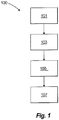
- FIG. 1 an illustrative view of an embodiment of a method in accordance with the disclosure is shown in Fig. 1 and is designated generally by reference character 100.
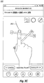
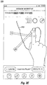
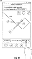
- FIGs. 2A-2H Other embodiments and/or aspects of this disclosure are shown in Figs. 2A-2H .
- the systems and methods described herein can be used to improve aircraft control and the ability of a user to make quick modifications to autonomous flight plans, for example. Any other suitable use is contemplated herein.
- a non-transitory computer readable medium includes computer executable instructions for performing a method 100 and/or any suitable portion thereof, the method 100 comprising generating 101 a graphical user interface (GUI) 200 on a display (e.g., a touch screen or any other suitable device).
- GUI graphical user interface
- the GUI 200 can be configured to display aircraft route information (e.g., terminal route information as shown).
- the aircraft route information can include an initial route 201 (e.g., calculated by an autonomous flight controller) before any inputs are received by the GUI 200, for example.
- the GUI 200 can include a text readout of an interpretation of the current route.
- the GUI 200 is configured to receive one or more real-time aircraft route inputs 203.
- the method 100 can also include receiving 103, at the GUI 200, the one or more real-time aircraft route inputs from an input device.
- the input device can be a touch screen as shown, a digital pointer (e.g., a mouse type pointer) or any other suitable input device configured to allow a route to be drawn freeform (e.g., via dragging as shown, via one or more input points). Any suitable input device is contemplated herein.
- the initial route 201 can disappear when the GUI 200 is receiving the one or more real-time aircraft route inputs 203, it is contemplated that the initial route 201 can stay visible for any suitable length of time, or until any suitable occurrence (e.g., the execution of a conformed route described below).
- the method 100 can include conforming 105 the one or more real-time aircraft route inputs 203 (e.g., as shown in Fig. 2F ) to a conformed route 205 (e.g., as shown in Fig. 2G ).
- the method 100 can include outputting 107 a conformed route to at least one of the GUI 200 (e.g., as shown) and/or an aircraft control system (e.g., an autonomous flight system or any suitable autopilot system). While it is shown, graphic display of the conformed route 205 is not necessary. However, display may be needed, for example, where a user must approve the conformed route to execute it.
- the method 100 can include displaying the real-time aircraft route inputs 203 as they are created.
- real-time route inputs 203 can be drag created (e.g., drawn on) using the input device.
- the input device can include a touchscreen interface, for example (e.g., to allow a user draw a route in real-time with their finger).
- Real-time aircraft route inputs 203 can be input in any other suitable manner (e.g.. by tapping and/or pointer clicking successive goalpoints on the screen instead of dragging).
- Conforming 105 the one or more real-time aircraft route inputs 203 to a conformed route 205 can include determining at least one of one or more route goalpoints, one or more altitudes along the route, one or more descent and/or climb rates along the route, one or more airspeeds along the route, one or more obstacle and/or terrain factors, and/or one or more aircraft system configurations along the route based on the one or more real-time aircraft route inputs. Any other suitable flight characteristics and/or factors affecting flight to be determined are contemplated herein.
- the one or more goalpoints can include one or more charted waypoints, for example (e.g., useable for an IFR flight plan).
- conforming 105 can include determining a present location of the aircraft and requiring the conformed route to include a path which the aircraft is already on so the aircraft does not start off-route.
- Conforming 105 can include flying the aircraft at a particular rate of descent (e.g., 500 feet per minute) as long as terrain and/or obstacle clearance is assured along the route.
- Any suitable conformance 105 for safety and/or for particular flight rules (e.g., VFR, IFR, etc.) or mission type (medevac, search and rescue, cargo, etc.,) is contemplated herein.
- a real-time aircraft route input 203 can be quite imperfect (e.g., due to the speed of drawing, due to flight roughness, etc.) compared to a path of straight line segments or smooth trajectories.
- Conforming 105 can therefore include squaring off the route input 203 (e.g., as shown) and/or otherwise smoothing the route input 203 in any suitable manner.
- conforming 105 the one or more real-time aircraft route inputs 203 to a conformed route 205 can include conforming 105 the real-time aircraft route inputs 203 to one or more flight standards.
- the one or more flight standards can include at least one of visual flight rules, instrument flight rules, obstacle clearance, traffic clearance, or airspace speed limitations. Any suitable standard is contemplated herein.
- the displayed aircraft route information can include an airport runway diagram (e.g., for the approach and landing phase of flight). Many airports have nice controlled/uncontrolled fields/runways with published information but in other missions (military for example or civil medevac) the landing site could be anywhere (e.g., a road, a field), and the displayed aircraft rout information can include an ad hoc diagram or landing zone display using any suitable available data for the unpublished/off-runway landing zone.
- an airport runway diagram e.g., for the approach and landing phase of flight.
- Many airports have nice controlled/uncontrolled fields/runways with published information but in other missions (military for example or civil medevac) the landing site could be anywhere (e.g., a road, a field)
- the displayed aircraft rout information can include an ad hoc diagram or landing zone display using any suitable available data for the unpublished/off-runway landing zone.
- Conforming 105 the one or more real-time aircraft route inputs 203 to a conformed route 205 can include approximating the one or more real-time aircraft route inputs 203 to an airport entry route (e.g., a midfield overflying entry as shown, a 45 degree downwind entry), an airport pattern (e.g., a traditional box left turn pattern as shown), and/or an approach (e.g., an instrument approach such as an ILS for runway 24). Any suitable terminal route conformance is contemplated herein. Also, embodiments disclosed herein can be used for any suitable phase or phases of flight (e.g., takeoff, climb out, cruise, descent, approach, landing).
- an airport entry route e.g., a midfield overflying entry as shown, a 45 degree downwind entry
- an airport pattern e.g., a traditional box left turn pattern as shown
- an approach e.g., an instrument approach such as an ILS for runway 24.
- Any suitable terminal route conformance is contemplated
- conforming 105 the one or more real-time aircraft route inputs 203 to a conformed route 205 can include receiving obstacle and/or terrain sensor data and/or traffic data for obstacle and/or terrain and/or traffic avoidance.
- the method 100 can include automatically updating the conformed route 205 based on the obstacle and/or terrain sensor data as the aircraft progresses along the route to avoid obstacles and/or terrain (e.g., that may be sensed after calculation of the conformed route).
- Traffic avoidance e.g., using inputs from ADS-B
- the method 100 can further include displaying the conformed route on the GUI 200 and requesting execution (e.g., via execute button 207) of the conformed route 205 before outputting the conformed route 205 to the aircraft control system.
- execution e.g., via execute button 207
- manual execution is not required and can be automated in any suitable manner.
- the conformed route 205 can be calculated and output (e.g., to the GUI 200 and/or to the aircraft control system) in real-time as the user inputs the real-time route input 203.
- the real-time route input 203 can be "snapped to" a conformed route as its input, for example.
- the aircraft control system can begin to fly the aircraft along the real-time calculated conforming route without prior manual execution from the user.
- conforming 105 can include a combination of auto snapping for certain things, e.g., squaring off patterns, flying to midfield, flying at 90 degrees to a runway, flying over numbers, but not for complete conformance of the route for other things (e.g., terrain avoidance calculations).
- an aircraft can include a navigational device (e.g., a suitable on-board aircraft navigational device, a Multi-Function Display (MFD)) having a non-transitory computer readable medium comprising computer executable instructions for performing a method 100 and/or any suitable portion thereof as described hereinabove.
- the aircraft can include one or more obstacle and/or terrain detection systems, e.g., configured to provide data to the navigational device.
- the one or more obstacle and/or terrain detection systems can include a LIDAR system, for example.
- the aircraft control system can be a smart system configured to control at least the aircraft position and power settings. Any other suitable control system is contemplated herein.
- a portable computing device can include a non-transitory computer readable medium having computer executable instructions for performing a method 100 and/or any suitable portion thereof as described hereinabove.
- the portable device can be a touch-screen tablet, for example, or any other suitable device.
- Embodiments can be implemented in any suitable non-portable device as well (e.g., an onboard computer, an air traffic control computer). Embodiments can be utilized by an onboard user and/or a remote user. Embodiments of a terminal route display may auto appear within a certain distance of an intended airport, for example. Any suitable GUI may be manually or automatically shown in any suitable manner.
- Any suitable customization of one or more features of embodiments of GUI 200 is contemplate herein (e.g., color selection of the route input).
- Any suitable buttons for any suitable function for any embodiments of the GUI 200 are contemplated herein (e.g., a "Cancel” button, a pencil button required to be selected before drawing or otherwise inputting a route can begin).
- Embodiments include an intuitive, quick way for an operator to input flight path changes into a path planner by electronically sketching the revised path directly on the display, e.g., with their finger, for example.
- the user can draw a new path and the underlying system is able to effectively discern the intent of the user in real-time as the user sketches and returns back a kinematically correct, updated path.
- Embodiments can be implemented and/or integrated in any suitable aircraft system and/or any suitable remote control system.
- embodiments of a GUI can be implemented on a ground control device for a remote user to operate a remotely controlled aircraft from the ground or any other suitable location.
- aspects of the present disclosure may be embodied as a system, method or computer program product. Accordingly, aspects of the present invention may take the form of an entirely hardware embodiment, an entirely software embodiment (including firmware, resident software, micro-code, etc.) or an embodiment combining software and hardware aspects that may all generally be referred to herein as a "circuit,” “module” or “system.” Furthermore, aspects of the present invention may take the form of a computer program product embodied in one or more computer readable medium(s) having computer readable program code embodied thereon.
- the computer readable medium may be a computer readable signal medium or a computer readable storage medium.
- a computer readable storage medium may be, for example, but not limited to, an electronic, magnetic, optical, electromagnetic, infrared, or semiconductor system, apparatus, or device, or any suitable combination of the foregoing.
- a computer readable storage medium may be any tangible medium that can contain, or store a program for use by or in connection with an instruction execution system, apparatus, or device.
- a computer readable signal medium may include a propagated data signal with computer readable program code embodied therein, for example, in baseband or as part of a carrier wave. Such a propagated signal may take any of a variety of forms, including, but not limited to, electro-magnetic, optical, or any suitable combination thereof.
- a computer readable signal medium may be any computer readable medium that is not a computer readable storage medium and that can communicate, propagate, or transport a program for use by or in connection with an instruction execution system, apparatus, or device.
- Program code embodied on a computer readable medium may be transmitted using any appropriate medium, including but not limited to wireless, wireline, optical fiber cable, RF, etc., or any suitable combination of the foregoing.
- Computer program code for carrying out operations for aspects of the present invention may be written in any combination of one or more programming languages, including an object oriented programming language such as Java, Smalltalk, C++ or the like and conventional procedural programming languages, such as the "C" programming language or similar programming languages.
- the program code may execute entirely on the user's computer, partly on the user's computer, as a stand-alone software package, partly on the user's computer and partly on a remote computer or entirely on the remote computer or server.
- the remote computer may be connected to the user's computer through any type of network, including a local area network (LAN) or a wide area network (WAN), or the connection may be made to an external computer (for example, through the Internet using an Internet Service Provider).
- LAN local area network
- WAN wide area network
- Internet Service Provider for example, AT&T, MCI, Sprint, EarthLink, MSN, GTE, etc.
- These computer program instructions may also be stored in a computer readable medium that can direct a computer, other programmable data processing apparatus, or other devices to function in a particular manner, such that the instructions stored in the computer readable medium produce an article of manufacture including instructions which implement the function/act specified in the flowchart and/or block diagram block or blocks.
- the computer program instructions may also be loaded onto a computer, other programmable data processing apparatus, or other devices to cause a series of operational steps to be performed on the computer, other programmable apparatus or other devices to produce a computer implemented process such that the instructions which execute on the computer or other programmable apparatus provide processes for implementing the functions/acts specified herein.
- aspects of the invention can be used in coaxial helicopters, on tail rotors, or wings or propeller blades on fixed or tilt wing aircraft.
- This invention provides a fast, intuitive way to communicate revised ATC instructions to the path planner. This method is faster than speaking or selecting multiple options from a pick list and lends itself to rotary wing operations where the helicopter doesn't necessarily need to land on a runway.
Landscapes
- Engineering & Computer Science (AREA)
- Physics & Mathematics (AREA)
- General Physics & Mathematics (AREA)
- Aviation & Aerospace Engineering (AREA)
- General Engineering & Computer Science (AREA)
- Theoretical Computer Science (AREA)
- Human Computer Interaction (AREA)
- Traffic Control Systems (AREA)
- User Interface Of Digital Computer (AREA)
- Navigation (AREA)
Applications Claiming Priority (1)
| Application Number | Priority Date | Filing Date | Title |
|---|---|---|---|
| US15/807,018 US20190139420A1 (en) | 2017-11-08 | 2017-11-08 | Aircraft route systems |
Publications (2)
| Publication Number | Publication Date |
|---|---|
| EP3483858A2 true EP3483858A2 (de) | 2019-05-15 |
| EP3483858A3 EP3483858A3 (de) | 2019-07-24 |
Family
ID=63524161
Family Applications (1)
| Application Number | Title | Priority Date | Filing Date |
|---|---|---|---|
| EP18192968.8A Withdrawn EP3483858A3 (de) | 2017-11-08 | 2018-09-06 | Flugroutensysteme |
Country Status (2)
| Country | Link |
|---|---|
| US (1) | US20190139420A1 (de) |
| EP (1) | EP3483858A3 (de) |
Families Citing this family (2)
| Publication number | Priority date | Publication date | Assignee | Title |
|---|---|---|---|---|
| WO2022070851A1 (ja) * | 2020-09-30 | 2022-04-07 | 株式会社Clue | 方法、システムおよびプログラム |
| CN115240475B (zh) * | 2022-09-23 | 2022-12-13 | 四川大学 | 融合飞行数据和雷达图像的航空器进近规划方法及装置 |
Citations (2)
| Publication number | Priority date | Publication date | Assignee | Title |
|---|---|---|---|---|
| JP2001306143A (ja) * | 2000-04-21 | 2001-11-02 | Yamaha Motor Co Ltd | 無人ヘリコプタの飛行制御システム |
| US20090319100A1 (en) * | 2008-06-20 | 2009-12-24 | Honeywell International Inc. | Systems and methods for defining and rendering a trajectory |
Family Cites Families (4)
| Publication number | Priority date | Publication date | Assignee | Title |
|---|---|---|---|---|
| US8073578B1 (en) * | 2008-09-18 | 2011-12-06 | Rockwell Collins, Inc. | Method and system for the cursor-aided manipulation of flight plans in two and three dimensional displays |
| US8401775B2 (en) * | 2009-01-30 | 2013-03-19 | The Boeing Company | Systems and method for managing airport ground traffic |
| US8552889B2 (en) * | 2010-02-18 | 2013-10-08 | The Boeing Company | Aircraft charting system with multi-touch interaction gestures for managing a route of an aircraft |
| US8797190B2 (en) * | 2012-07-26 | 2014-08-05 | General Electric Company | Method for displaying a user entered flight path |
-
2017
- 2017-11-08 US US15/807,018 patent/US20190139420A1/en not_active Abandoned
-
2018
- 2018-09-06 EP EP18192968.8A patent/EP3483858A3/de not_active Withdrawn
Patent Citations (2)
| Publication number | Priority date | Publication date | Assignee | Title |
|---|---|---|---|---|
| JP2001306143A (ja) * | 2000-04-21 | 2001-11-02 | Yamaha Motor Co Ltd | 無人ヘリコプタの飛行制御システム |
| US20090319100A1 (en) * | 2008-06-20 | 2009-12-24 | Honeywell International Inc. | Systems and methods for defining and rendering a trajectory |
Also Published As
| Publication number | Publication date |
|---|---|
| EP3483858A3 (de) | 2019-07-24 |
| US20190139420A1 (en) | 2019-05-09 |
Similar Documents
| Publication | Publication Date | Title |
|---|---|---|
| AU2015200083B2 (en) | Landing alerts for preventing runway excursions | |
| US20220189325A1 (en) | Autonomous path planning | |
| US8682580B2 (en) | Data driven route strip | |
| US10175388B2 (en) | 4D volumetric weather data processing and display | |
| CN103991552B (zh) | 用于图示飞行器处境信息的方法 | |
| EP2922046B1 (de) | System und Verfahren zur Bereitstellung verbesserter Flugplanverwaltung | |
| US8977481B1 (en) | Unmanned aircraft navigation system | |
| EP2975596B1 (de) | Systeme und verfahren zur flughafenverkehrskontrolle | |
| US8781654B2 (en) | Method and device for aiding the approach of an aircraft during an approach phase for the purpose of landing | |
| US9008873B1 (en) | Methods and systems for landing decision point | |
| CN105303893A (zh) | 用于提供增强的hmi导航的系统和方法 | |
| US10584979B1 (en) | Vertical situation display with interactive speed profile bar | |
| US10852157B2 (en) | Guidance display for controlling aircraft turns for aircraft spacing | |
| EP2648175A2 (de) | Anweisungsvisualisierungssystem | |
| CN107014383A (zh) | 飞行器中的气象数据的显示 | |
| CN108073178A (zh) | 用于航空器的平台进近的标准化 | |
| CN106681355A (zh) | 用于在进场阶段协助飞行器航行以管理能量的方法和装置 | |
| US20260105854A1 (en) | Traffic pattern control of uavs and automated downwind extensions | |
| EP3483858A2 (de) | Flugroutensysteme | |
| US10839698B1 (en) | Methods and systems for depicting an energy state of a vehicle | |
| EP4495914A1 (de) | Systeme und verfahren zur anzeige einer landebahnerweiterung auf einem flugzeug | |
| Cauchi et al. | A decision support tool for weather and terrain avoidance during departure | |
| CN116134501A (zh) | 在进近阶段自动选择飞行器飞行计划 | |
| Ball | UAS NAS access-Discussion at ICNS: Potential enhancements to UAS Flight Data information flow to ATC |
Legal Events
| Date | Code | Title | Description |
|---|---|---|---|
| PUAI | Public reference made under article 153(3) epc to a published international application that has entered the european phase |
Free format text: ORIGINAL CODE: 0009012 |
|
| STAA | Information on the status of an ep patent application or granted ep patent |
Free format text: STATUS: THE APPLICATION HAS BEEN PUBLISHED |
|
| AK | Designated contracting states |
Kind code of ref document: A2 Designated state(s): AL AT BE BG CH CY CZ DE DK EE ES FI FR GB GR HR HU IE IS IT LI LT LU LV MC MK MT NL NO PL PT RO RS SE SI SK SM TR |
|
| AX | Request for extension of the european patent |
Extension state: BA ME |
|
| PUAL | Search report despatched |
Free format text: ORIGINAL CODE: 0009013 |
|
| AK | Designated contracting states |
Kind code of ref document: A3 Designated state(s): AL AT BE BG CH CY CZ DE DK EE ES FI FR GB GR HR HU IE IS IT LI LT LU LV MC MK MT NL NO PL PT RO RS SE SI SK SM TR |
|
| AX | Request for extension of the european patent |
Extension state: BA ME |
|
| RIC1 | Information provided on ipc code assigned before grant |
Ipc: G01S 13/94 20060101ALI20190619BHEP Ipc: G08G 5/00 20060101AFI20190619BHEP |
|
| STAA | Information on the status of an ep patent application or granted ep patent |
Free format text: STATUS: REQUEST FOR EXAMINATION WAS MADE |
|
| 17P | Request for examination filed |
Effective date: 20200124 |
|
| RBV | Designated contracting states (corrected) |
Designated state(s): AL AT BE BG CH CY CZ DE DK EE ES FI FR GB GR HR HU IE IS IT LI LT LU LV MC MK MT NL NO PL PT RO RS SE SI SK SM TR |
|
| STAA | Information on the status of an ep patent application or granted ep patent |
Free format text: STATUS: EXAMINATION IS IN PROGRESS |
|
| 17Q | First examination report despatched |
Effective date: 20211116 |
|
| STAA | Information on the status of an ep patent application or granted ep patent |
Free format text: STATUS: THE APPLICATION IS DEEMED TO BE WITHDRAWN |
|
| 18D | Application deemed to be withdrawn |
Effective date: 20220329 |