EP3516582B1 - Détermination de parcours autonome - Google Patents
Détermination de parcours autonome Download PDFInfo
- Publication number
- EP3516582B1 EP3516582B1 EP17777333.0A EP17777333A EP3516582B1 EP 3516582 B1 EP3516582 B1 EP 3516582B1 EP 17777333 A EP17777333 A EP 17777333A EP 3516582 B1 EP3516582 B1 EP 3516582B1
- Authority
- EP
- European Patent Office
- Prior art keywords
- images
- vehicle
- environment
- path
- data
- Prior art date
- Legal status (The legal status is an assumption and is not a legal conclusion. Google has not performed a legal analysis and makes no representation as to the accuracy of the status listed.)
- Active
Links
Images






Classifications
-
- B—PERFORMING OPERATIONS; TRANSPORTING
- B60—VEHICLES IN GENERAL
- B60W—CONJOINT CONTROL OF VEHICLE SUB-UNITS OF DIFFERENT TYPE OR DIFFERENT FUNCTION; CONTROL SYSTEMS SPECIALLY ADAPTED FOR HYBRID VEHICLES; ROAD VEHICLE DRIVE CONTROL SYSTEMS FOR PURPOSES NOT RELATED TO THE CONTROL OF A PARTICULAR SUB-UNIT
- B60W60/00—Drive control systems specially adapted for autonomous road vehicles
- B60W60/001—Planning or execution of driving tasks
- B60W60/0015—Planning or execution of driving tasks specially adapted for safety
- B60W60/0016—Planning or execution of driving tasks specially adapted for safety of the vehicle or its occupants
-
- G—PHYSICS
- G06—COMPUTING OR CALCULATING; COUNTING
- G06V—IMAGE OR VIDEO RECOGNITION OR UNDERSTANDING
- G06V20/00—Scenes; Scene-specific elements
- G06V20/50—Context or environment of the image
- G06V20/56—Context or environment of the image exterior to a vehicle by using sensors mounted on the vehicle
- G06V20/58—Recognition of moving objects or obstacles, e.g. vehicles or pedestrians; Recognition of traffic objects, e.g. traffic signs, traffic lights or roads
-
- G—PHYSICS
- G05—CONTROLLING; REGULATING
- G05D—SYSTEMS FOR CONTROLLING OR REGULATING NON-ELECTRIC VARIABLES
- G05D1/00—Control of position, course, altitude or attitude of land, water, air or space vehicles, e.g. using automatic pilots
- G05D1/0088—Control of position, course, altitude or attitude of land, water, air or space vehicles, e.g. using automatic pilots characterized by the autonomous decision making process, e.g. artificial intelligence, predefined behaviours
-
- B—PERFORMING OPERATIONS; TRANSPORTING
- B60—VEHICLES IN GENERAL
- B60W—CONJOINT CONTROL OF VEHICLE SUB-UNITS OF DIFFERENT TYPE OR DIFFERENT FUNCTION; CONTROL SYSTEMS SPECIALLY ADAPTED FOR HYBRID VEHICLES; ROAD VEHICLE DRIVE CONTROL SYSTEMS FOR PURPOSES NOT RELATED TO THE CONTROL OF A PARTICULAR SUB-UNIT
- B60W30/00—Purposes of road vehicle drive control systems not related to the control of a particular sub-unit, e.g. of systems using conjoint control of vehicle sub-units
- B60W30/08—Active safety systems predicting or avoiding probable or impending collision or attempting to minimise its consequences
- B60W30/095—Predicting travel path or likelihood of collision
- B60W30/0956—Predicting travel path or likelihood of collision the prediction being responsive to traffic or environmental parameters
-
- G—PHYSICS
- G05—CONTROLLING; REGULATING
- G05D—SYSTEMS FOR CONTROLLING OR REGULATING NON-ELECTRIC VARIABLES
- G05D1/00—Control of position, course, altitude or attitude of land, water, air or space vehicles, e.g. using automatic pilots
- G05D1/02—Control of position or course in two dimensions
- G05D1/021—Control of position or course in two dimensions specially adapted to land vehicles
- G05D1/0231—Control of position or course in two dimensions specially adapted to land vehicles using optical position detecting means
- G05D1/0246—Control of position or course in two dimensions specially adapted to land vehicles using optical position detecting means using a video camera in combination with image processing means
-
- G—PHYSICS
- G06—COMPUTING OR CALCULATING; COUNTING
- G06Q—INFORMATION AND COMMUNICATION TECHNOLOGY [ICT] SPECIALLY ADAPTED FOR ADMINISTRATIVE, COMMERCIAL, FINANCIAL, MANAGERIAL OR SUPERVISORY PURPOSES; SYSTEMS OR METHODS SPECIALLY ADAPTED FOR ADMINISTRATIVE, COMMERCIAL, FINANCIAL, MANAGERIAL OR SUPERVISORY PURPOSES, NOT OTHERWISE PROVIDED FOR
- G06Q10/00—Administration; Management
- G06Q10/08—Logistics, e.g. warehousing, loading or distribution; Inventory or stock management
- G06Q10/083—Shipping
- G06Q10/08355—Routing methods
-
- G—PHYSICS
- G06—COMPUTING OR CALCULATING; COUNTING
- G06V—IMAGE OR VIDEO RECOGNITION OR UNDERSTANDING
- G06V10/00—Arrangements for image or video recognition or understanding
- G06V10/70—Arrangements for image or video recognition or understanding using pattern recognition or machine learning
- G06V10/764—Arrangements for image or video recognition or understanding using pattern recognition or machine learning using classification, e.g. of video objects
-
- G—PHYSICS
- G06—COMPUTING OR CALCULATING; COUNTING
- G06V—IMAGE OR VIDEO RECOGNITION OR UNDERSTANDING
- G06V10/00—Arrangements for image or video recognition or understanding
- G06V10/70—Arrangements for image or video recognition or understanding using pattern recognition or machine learning
- G06V10/77—Processing image or video features in feature spaces; using data integration or data reduction, e.g. principal component analysis [PCA] or independent component analysis [ICA] or self-organising maps [SOM]; Blind source separation
- G06V10/774—Generating sets of training patterns; Bootstrap methods, e.g. bagging or boosting
-
- G—PHYSICS
- G06—COMPUTING OR CALCULATING; COUNTING
- G06V—IMAGE OR VIDEO RECOGNITION OR UNDERSTANDING
- G06V10/00—Arrangements for image or video recognition or understanding
- G06V10/70—Arrangements for image or video recognition or understanding using pattern recognition or machine learning
- G06V10/82—Arrangements for image or video recognition or understanding using pattern recognition or machine learning using neural networks
-
- G—PHYSICS
- G06—COMPUTING OR CALCULATING; COUNTING
- G06V—IMAGE OR VIDEO RECOGNITION OR UNDERSTANDING
- G06V20/00—Scenes; Scene-specific elements
- G06V20/50—Context or environment of the image
- G06V20/56—Context or environment of the image exterior to a vehicle by using sensors mounted on the vehicle
-
- G—PHYSICS
- G06—COMPUTING OR CALCULATING; COUNTING
- G06V—IMAGE OR VIDEO RECOGNITION OR UNDERSTANDING
- G06V20/00—Scenes; Scene-specific elements
- G06V20/50—Context or environment of the image
- G06V20/56—Context or environment of the image exterior to a vehicle by using sensors mounted on the vehicle
- G06V20/588—Recognition of the road, e.g. of lane markings; Recognition of the vehicle driving pattern in relation to the road
Definitions
- This invention relates to the generation of a proposed path, and more particularly to a weakly-supervised approach to segmenting proposed drivable paths in images with the goal of autonomous driving in various environments, including urban environments.
- the invention is described herein with reference to a data collection vehicle recording a route. However, the skilled person will appreciate that the invention is more widely applicable and may use route images collected in any way, including collating images from a variety of different sources.
- the invention is described herein in relation to autonomous or semi-autonomous vehicles driving through urban environments, but the skilled person will appreciate that the path proposals identified may be used for other purposes (for example, to identify a route for a person to walk), and that the techniques may be applied to non-urban environments. Nonetheless, the invention is currently expected to have particular utility in the field of autonomous vehicles driving in urban environments.
- Road scene understanding is a critical component for decision making and safe operation of autonomous vehicles in urban environments. Given the structured nature of on-road driving, all autonomous vehicles must follow the "rules of the road”; crucially, driving within designated lanes in the correct direction and negotiating intersections.
- LIDAR see A. S. Huang, D. Moore, M. Antone, E. Olson, and S. Teller, "Finding multiple lanes in urban road networks with vision and LIDAR", Autonomous Robots, vol. 26, no. 2-3, pp. 103-122, 2009 ) but at an increased sensor cost.
- Deep networks make use of the full image context to perform semantic labelling of road and lane markings, and hence are significantly more robust than previous feature-based methods.
- these approaches depend on large-scale manually-annotated road scene datasets (notably CamVid ( G. J. Brostow, J. Fauqueur, and R. Cipolla, "Semantic object classes in video: A high-definition ground truth database ", Pattern Recognition Letters, vol. 30, no. 2, pp.
- a recent method uses sparse 3D prior information to transfer labels to real-world 2D images (see J. Xie, M. Kiefel, M.T. Sun, and A. Geiger, "Semantic instance annotation of street scenes by 3D to 2D label transfer", in Conference on Computer Vision and Pattern Recognition (CVPR), 2016 ) but requires sophisticated 3D reconstructions and manual 3D annotations.
- the method may require little or no supervision, and/or may not require manual labelling of images.
- the method comprises obtaining data from a data collection vehicle driven through an environment, the data comprising:
- the method comprises using the obstacle sensing data to label one or more portions of at least some of the images as obstacles.
- the method comprises using the vehicle odometry data to label one or more portions of at least some of the images as the path taken by the vehicle through the environment.
- the training dataset is created from the labelled images, and may or may not be constituted by the labelled images (i.e. the creation of the training dataset may simply comprise collating the labelled images, without the addition of any further data or image processing, or there may be additional data).
- the method may further comprise a calibration process to allow the odometry data and the obstacle sensing data to be matched to the images.
- an autonomous vehicle as defined by claim 5.
- the vehicle comprises a sensor arranged to capture images of an environment around the autonomous vehicle.
- a route of the autonomous vehicle through the environment is determined by the segmentation unit using images captured by the sensor.
- additional systems may be used to make a decision based on the path proposals from the segmentation unit.
- the autonomous vehicle may only comprise a monocular camera, as monocular camera data is sufficient for the trained segmentation unit.
- the data collection vehicle may also be the autonomous vehicle of the further aspect of the invention.
- obstacle sensing data and odometry data may or may not be recorded whilst driving autonomously. A different vehicle is therefore not required.
- Embodiments of the invention are described in relation to a sensor 12 mounted upon a vehicle 10, as is shown in Figure 1 .
- vehicle 10 could be replaced by a plane, boat, aerial vehicle or robot, or by a person carrying a sensor 12, amongst other options.
- the sensor used may be stationary.
- any feature or combination of features described with respect to one embodiment may be applied to any other embodiment.
- the embodiment being described utilises a weakly-supervised approach 100 to segmenting path proposals for a road vehicle 10 in urban environments given a single monocular input image 112. Weak supervision is used to avoid expensive manual labelling by using a more readily available source of labels instead.
- weak supervision involves creating labels of the proposed path in images 112 by leveraging the route actually travelled by a road vehicle 10.
- the labels are pixel-wise; i.e. pixels of an image 112 are individually labelled.
- the approach 100 is capable of segmenting a proposed path 14 for a vehicle 10 in a diverse range of road scenes, without relying on explicit modelling of lanes or lane markings.
- path proposal is defined as a route a driver would be expected to take through a particular road and traffic configuration.
- the approach 100 described herein uses the path taken 14a by the data collection vehicle 10 as it travels through an environment to implicitly label proposed paths 14 in the image 106 in the training phase, but may still allow a planning algorithm to choose the best path 14 for the a route in the deployment phase.
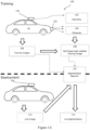
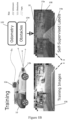
- a method 100 of automatically generating labelled images 114 containing path proposals 14 by leveraging the behaviour of the data collection vehicle driver along with additional sensors 12a, 12b mounted to the vehicle 10, is described, as illustrated in Figure 1A and Figure 1B .
- the skilled person will appreciate that the data collection vehicle 10 could be an autonomous vehicle, with no driver, in some embodiments.
- labelled training data 106 can be generated without any manual annotation, spanning a wide variety of road and traffic configurations under a number of different lighting and weather conditions limited only by the time spent driving the data collection vehicle 10.
- This labelled training data 106 can be thought of as weakly-supervised input for training a path segmentation unit 110.
- the only "supervision” or supervisory signal is the behaviour of the data collection vehicle driver; the driver itself may be an autonomous unit.
- the only "supervision" or supervisory signal used, by the embodiment being described to label training date may be the movements of the data collection vehicle; manual seeding or labelling of training images may therefore be substantially or completely avoided.
- Embodiments of the invention as disclosed herein relate not only to the method of generating a training dataset 108 described, but also to the resultant training dataset itself, and to applications of that dataset.
- the method 100 described allows a training dataset to be generated without any manual labeling - either of each training image, or of one training image (or a subset of training images) which is then used as a seed which allows labels to be propagated to other images.
- a set of labeled images 108 generated by the method 100 disclosed herein may form part of a training dataset which also includes manually labeled images, images labeled by a different technique and/or unlabeled images.
- the training dataset 108 produced is arranged to be used in autonomous route determination.
- the training dataset shows examples of paths 14a within images 106 which were chosen by a driver (or an autonomous vehicle 10).
- a segmentation unit 110 such as SegNet - V. Badrinarayanan, A. Handa, and R. Cipolla, "SegNet: A deep convolutional encoder-decoder architecture for robust semantic pixelwise labelling," arXiv preprint arXiv:1505.07293, 2015 .
- trained on the training dataset 108 is therefore taught to identify a path 14 within an image 112 that would be likely to be chosen by a driver.
- the data collection vehicle 10 is equipped with a camera 12a and odometry and obstacle sensors 12b.
- the vehicle 10 is used to collect data 102, 104, 106 during normal driving (first (ie leftmost) part of Figure 1B ).
- the data 102, 104, 106 comprises odometry data 102, obstacle data 104 and visual images 106.
- other data may generated and for example, it is possible that the visual images, in particular, may be replaced with other representations of the environment, such as LiDAR scans, or the like.
- the visual images 106 obtained by the data collection vehicle 10 are described as training images 106 as these are labelled as described below and then used to train one or more systems or devices to identify path proposals in other images (that is proposed paths for a vehicle to traverse the environment contained within the visual images 106).
- the training images 106 are used to train a segmentation framework (in particular a deep semantic segmentation network 110), which may be a neural network such that the trained segmentation framework can predict routes likely to be driven by a driver who contributed to the training dataset in new/unknown scenes.
- a segmentation framework in particular a deep semantic segmentation network 110
- the trained segmentation framework can predict routes likely to be driven by a driver who contributed to the training dataset in new/unknown scenes.
- the segmentation framework can then be used to inform a route planner.
- route planners generally operate by minimising a cost function so as to provide a recommended route.
- the segmentation framework is arranged to output a suitable cost function for a route planner, or suitable parameters for a cost function of a route planner.
- the training data 106 can therefore be used to train a system able to predict routes likely to be driven by the original driver through a scene at hand. That system can then be used to inform a trajectory planner/route planner (e.g. via mapping the route proposal into a planner cost function).
- the planner may or may not be separate from the trained system.
- a single sensor 12 may provide both odometry 102 and obstacle 104 data. In yet further embodiments, more sensors may be provided.
- the odometry 102 and obstacle data 104 is projected into the training images 106 to generate weakly-supervised labels 108 relevant for traversing through the environment, such as used in autonomous driving.
- the chosen labels are "Unknown", “Obstacles” and “Path” in the embodiment being described. In alternative or additional embodiments, more, fewer or different labels may be used. For example, “Unknown” may not be used, and/or "Obstacles" may be subdivided by obstacle type.
- the labels are used to classify regions of the training images 106.
- diagonal lines sloped at an acute angle to the horizontal, as measured from the right hand side (///) are used to mark regions identified as "Unknown" 16
- diagonal lines sloped at an obtuse angle to the horizontal, as measured from the right hand side ( ⁇ ) are used to mark regions identified as "Obstacles" 15a
- broken diagonal lines are used to mark regions identified as "Path" 14a.
- the labelled images 108 are, in the embodiment being described, used to train a deep semantic segmentation network 110.
- a deep semantic network 110 was used in the embodiment being described, other machine learning systems may be used as a segmentation unit 110 instead of or as well as a deep semantic network 110 (any of these may be referred to as a segmentation network 110).
- the segmentation unit 110 may be implemented in software and may not have unique hardware, or vice versa.
- a vehicle 10 equipped with only a monocular camera 12a can perform live segmentation of the drivable path eg 14a and obstacles 15a using the trained segmentation network 110 (second part of Figure 1B ), even in the absence of explicit lane markings.
- the vehicle 10 used at run-time may be the same as that used for data collection, or a different vehicle.
- a monocular camera 12a is sufficient, alternative or additional sensors may be used.
- the data was used to train an off-the-shelf deep semantic segmentation network 110 (e.g. SegNet, see the paper of V. Badrinarayanan et al. cited above) to produce path proposal segmentations 114 using only a monocular input image 112 (e.g. a photograph).
- the deep semantic segmentation network 110 may then be used as part of, or to feed into, a route planner, which may be an in-car or portable device used to suggest routes to a driver/user.
- the approach 100 was evaluated using two large-scale autonomous driving datasets: the KITTI dataset (see A. Geiger, P. Lenz, C. Stiller, and R. Urtasun, "Vision meets robotics: The KITTI dataset", The International Journal of Robotics Research, p. 0278364913491297, 2013 ), collected in Düsseldorf, Germany, and the large-scale Oxford RobotCar Dataset (http://robotcar-dataset.robots.ox.ac.uk), consisting of over 1000 km of recorded driving in Oxford, UK, over the period of a year.
- an embodiment of the invention for generating weakly-supervised training data 108 for proposed path segmentation using video and other sensor data recorded from a (in the embodiment being described) manually-driven vehicle 10 is outlined.
- the vehicle 10 used to record video and other sensor data may be autonomously driven, but embodiments of the invention are described below in relation to a manually driven data collection vehicle 10 as this was the arrangement used for the test results described. The skilled person will appreciate that other factors specific to the test performed may be varied or eliminated in other embodiments of the invention.
- the image 106 is described as being segmented, forming a segmented image 108.
- the segmented images 108 can be used as training data.
- a segmentation unit 110 can then segment new images 112 in the same way, so forming new segmented images 114.
- the segmented images 114 formed at run-time may optionally be added to the training data 108 and used in the training phase thereafter, optionally subject to driver/user approval.
- the approach 100 of the embodiment being described uses the following two capabilities of the data collection vehicle 10:
- a vehicle odometry system 12a and an obstacle sensing system 12b may be mounted on, or integral with, the data collection vehicle 10. In either case, the sensing systems 12a, 12b move with the vehicle 10 and may therefore be described as being onboard the vehicle 10.
- vehicle odometry 102 and obstacle sensing 104 capabilities used for collecting training data 106, 108 are not required when using the training data, nor when operating an autonomous vehicle 10 using a segmentation unit 110 trained on the training data; the resulting network can operate with only a monocular input image 112, although the skilled person will appreciate that additional sensors and/or data inputs may also be used.
- FIG. 2 illustrates the sensor extrinsics for a vehicle 10 equipped with a stereo camera 12a and LIDAR sensor 12b.
- the skilled person will appreciate that other camera types may be used to collect the input images 106 in other embodiments, and/or that a camera 12b forming part of a visual odometry system 12b may provide the images 106.
- Figure 2 shows the data collection vehicle 10 equipped with a camera C 12a and obstacle sensor L 12b, e.g. a LIDAR scanner.
- the extrinsic transform G CL between the camera 12a and LIDAR scannner 12b is found using a calibration routine.
- the contact point c ⁇ l,r ⁇ of the left (l) and right (r) wheels on the ground relative to the camera frame C is also measured at calibration time.
- the LIDAR scanner observes a number of points p t 1 ... n on obstacles 15, including other vehicles 15 on the road.
- the relative pose G CtC t+1 of the camera between time t and t +1 is determined using vehicle odometry, e.g. using a stereo camera.
- the relative pose G CtC t+1 can be used to determine the motion of the vehicle 10.
- pixels of images are assigned to, and labelled as being part of, one or more classes (ie they have class labels associated with them).
- class labels for pixels in the input image(s) 112
- recorded data from the data collection vehicle 10 driven by a human driver in a variety of traffic and weather conditions is used in the embodiment being described.
- the classes/labels described herein correspond to obstacles 15 in the environment which are in front of the data collection vehicle 10, path taken 14 by the data collection vehicle 10 through the environment, and "unknown" for the remainder 16, i.e. for any unlabeled area(s).
- fewer classes may be used (e.g. not using "unknown") and/or more classes may be used (e.g. separating dynamic and static obstacles, or obstacles in front of the vehicle from other obstacles).
- each pixel is assigned to a class 14, 15, 16. In alternative embodiments, some pixels may be unassigned, and/or averages may be taken across pixel groups. In this way, different portions of an image 106, 112 are labeled as belonging to different classes (or not labeled, in some embodiments). There may be more than one portion of an image 106, 112 relating to the same class within a single image; for example, an obstacle on the road as well as obstacles on either side of the road. In some images 106, 112, there may be no portion(s) in a particular class; for example where the image represents a portion of the environment fully within the vehicle's path, with no obstacles 15 or unknown areas 16.
- Labels 14, 15, 16 are then generated by projecting the future path of the vehicle 10 into each image 112, over which object labels as detected by the LIDAR scanner are superimposed as follows.
- "Future” in this context means after the image in question 112 was taken - the "future” path is the path driven by the vehicle 10, as recorded by the odometry system 12b during the training phase (first part of Figure 1B ), and is the proposed path for a vehicle 10 to take in the deployment phase (second part of Figure 1B ).
- the segmentation unit 110 segments new images 112 (i.e. images not forming part of the training dataset) provided to it in accordance with its training, thereby marking proposed paths 14 within the new images 112.
- the segmentation unit 110 may be onboard an autonomous (or semi-autonomous) vehicle 10 and arranged to receive images 112 taken by a camera 12a on the autonomous vehicle 10 and to process those images so as to propose a path 14 by segmentation 114 of the image.
- the route proposals 14 may be provided in real-time so as to enable the output of the segmentation unit 110 to be used in directing the vehicle 10.
- the embodiments being described use real images 106 and vehicle path data 102 for the training dataset/to train the system.
- the supervisory signal as to a proposed path 14 is the path 14a actually driven by the data collection vehicle 10, projected into the image 106 as a label (shown in Fig 3 .). That combined with the obstacle labels 15 allows an informative training image 108 and general representation to be generated.
- the embodiments described allow for multiple proposed paths 14 (for example left and right at an intersection) and obstacle segmentations 15.
- an additional system may be used after the segmentation to decide how to utilise the path proposals 14.
- the labeled images 108 produced may be used as a test dataset as well as, or instead of, as a training dataset.
- a trained segmentation unit 110 could be given the images 106 of the test dataset without segmentation information 108 and the output of the trained segmentation unit can then be compared to the segmented images 108 of the test dataset to assess the performance of the segmentation unit 110. Any features described with respect to the training data set may therefore be applied equally to a test data set.
- Proposed path projection To project the future path 14a of the vehicle 10 into the current frame 106, the size of the vehicle 10 and the points of contact with the ground during the trajectory are used. The position of the contact points c ⁇ l,r ⁇ of the front left and right wheels on the ground relative to the camera C may be determined as part of a calibration procedure.
- Proposed path pixel labels 14 are then formed by filling quadrilaterals in image coordinates corresponding to sequential future frames.
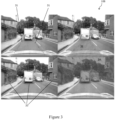
- An illustration of the proposed path projection and labelling process is shown in Figure 3 .
- FIG. 3 shows ground contact points 31 (top two images) and obstacle points 33 (bottom two images) projected into images 106.
- ground contact points c ⁇ l,r ⁇ ,j top left, 31
- Pixel labels corresponding to drivable paths 14 are filled in by drawing quadrilaterals between the left and right contact points between two successive frames (top right).
- obstacle points p t i 33 from the current LIDAR scan are projected into the image 106 (bottom left).
- Pixel labels corresponding to obstacles are formed by extending each of these points to the top of the image (bottom right, 34). Note that the top and bottom sections of the image 106 corresponding to the sky and vehicle bonnet are removed before training in this embodiment.
- frame count k depends on the look-ahead distance required for path labelling and the accuracy of the vehicle odometry system 12b used to provide relative frame transforms. In practice k is chosen such that the distance between first and last contact points ⁇ G CtC t+k c ⁇ l,r ⁇ - c ⁇ l,r ⁇ ⁇ exceeds roughly 60 metres. Different camera setups with higher viewpoints may require greater path distances, but accumulated odometry error will affect far-field projections. In other embodiments, distances such as roughly any of the following may be chosen: 30m, 40m, 50m, 70m, 80m, 90m, 100, or any distance inbetween.
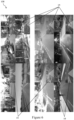
- Figure 4 shows proposed path labels 14 for an input image (top) before (middle) and after (bottom) applying obstacle labels from the LIDAR scanner 12b.
- the proposed path 42 intersects vehicles 41 (or cyclists 43, pedestrians 47 or the likes) in the same lane as the path driven by the data collection vehicle 10, which in this case will erroneously label sections of the white van 41 as drivable route 14.
- Adding labels for obstacles 15 ensures that dynamic objects including the van 41, cyclist 43 and pedestrian 47 are marked as non-drivable, leading to a different proposed path 14.
- static obstacles 49 such as the road sign 49a and the building 49b are also labelled as obstacles 15, which correctly handles occlusions (e.g. as the path turns right after the traffic lights 49c).
- the remaining portion, 45 may be labeled unknown.
- Obstacle projection For some applications it may be sufficient to use just the proposed path labels 14 to train a semantic segmentation network 110. However, for on-road applications in the presence of other vehicles 41 and dynamic objects, a naive projection of the path driven will intersect vehicles 41 in the same lane and label them as drivable paths 42 as illustrated in Figure 4 . In the centre figure of Figure 4 , it can be seen that the path 42 is intersected with the vehicle 41.
- Intersecting paths with vehicles in this manner may lead to catastrophic results when the labelled images 108 are used to plan paths for autonomous driving, since vehicles and traffic may be labelled as traversable by the network.
- K is the camera projection matrix
- G CL is the SE(3) extrinsic calibration between the camera and LIDAR sensor.
- Obstacle pixel labels 15 take precedence over proposed path labels 14 in the embodiment being described to facilitate correct labelling of safe drivable paths/the chosen path 14 as illustrated in Figure 4 .
- locations 116 labelled as neither proposed path nor obstacle. These correspond to locations 116 which the vehicle10 has not traversed (and hence is not known to be traversable and is not part of the chosen path 14), but no positive identification of obstacles 15 have been made. Typically these areas correspond to the road area outside the current lane (including lanes for oncoming traffic), kerbs, empty pavements and ditches. These locations are referred to as "unknown area" 16, as it is not clear whether the vehicle 10 should enter these spaces during autonomous operation; this would be a decision for a higher-level planning framework as discussed below.
- FIG. 4 Examples of unknown areas 16 can be seen in Figure 4 , in which region 45 is marked as unknown - this region 45 comprises road surface over which the vehicle 10 has not driven and some pavement area. Similarly in Figure 6 , pavement and unused road areas are classed as unknown areas 16. The grass 86 in Figure 8 is also classed as unknown 16.
- these labelled images 108 can be used to train a semantic segmentation network 110 to classify new images 112 from a different vehicle 10 (or from the same vehicle, in some embodiments).
- this different vehicle 10 was equipped with only a monocular camera 12a.
- SegNet is used: a deep convolutional encoder-decoder architecture for pixel-wise semantic segmentation. Although higher-performing network architectures now exist (e.g. G. Papandreou, L. C. Chen, K. Murphy, and A. L. Yuille, "Weakly- and semi-supervised learning of a DCNN for semantic image segmentation", arXiv preprint arXiv:1502.02734, 2015 ), and others could be used, Seg-Net provides real-time evaluation on consumer GPUs, making it suitable for deployment in an autonomous vehicle 10.
- the weakly-supervised labelling approach 100 being described can generate vast quantities of training data 108, limited only by the length of time spent driving the data collection vehicle 10. However, the types of routes driven will also bias the input data 102, 104, 106. As most on-road driving is performed in a straight line; a random sample of the training data will consist mostly of straight-line driving. In practice the data were subsampled to 4Hz, before further subsampling based on turning angle.
- ⁇ ( G ) is a function that extracts the Euler yaw angle ⁇ from the SE(3) transform matrix B.
- a histogram of average yaw rates was then built and random samples taken from the histogram bins to ensure an unbiased selection of different turning angles.
- Both vehicles 10 are equipped with stereo camera systems 12a and the stereo visual odometry approach described in the PhD thesis of W. Churchill cited above is used to compute the relative motion estimates required in Eq. 2.
- the images 112 from the cameras 12a are cropped and downscaled to the resolutions listed in Table I before training.
- the Oxford RobotCar is equipped with a SICK LD-MRS LIDAR scanner/sensor 12b, which performs obstacle merging and tracking across 4 scanning planes in hardware. Points identified as "object contours" are used to remove erroneous obstacles due to noise and ground-strike.
- the Velodyne HDL-64E mounted on the AnnieWAY vehicle does not perform any object filtering, and hence the following approach is used to detect obstacles: a ground plane is fitted to the 3D LIDAR scan using MLESAC (see P. H. Torr and A. Zisserman, "Mlesac: A new robust estimator with application to estimating image geometry", Computer Vision and Image Understanding, vol. 78, no. 1, pp.
- FIG. 5 shows obstacle labelling using Velodyne data for the KITTI dataset.
- Raw Velodyne scans top image
- a scanned region 5a and an unscanned region 5b of the image 500 are shown.
- the Velodyne scan data are indicated by light-coloured lines throughout the scanned region 5a.
- a ground plane is fitted using MLESAC, and only points of the Velodyne scan data 0.25m above the plane are maintained (middle image). This is represented in the figures by removal of the light-coloured lines in the regions below 0.25m from the ground plane.
- Pixels 54 which correspond to areas of the Velodyne scan data 0.25m or more above the ground plane are then labelled as obstacles using the approach described above (bottom image) to ensure accurate labels on obstacles 15 while retaining potentially drivable surfaces 52 on the ground (shaded pixels with ⁇ in bottom image).
- One or more areas of the potentially drivable surfaces 52 may then be labelled as path 14 and/or as unknown 16 using the approach described herein.
- the camera-LIDAR calibration G CL for the RobotCar vehicle 10 was determined using the method in G. Pascoe, W. Maddern, and P. Newman, "Direct visual localisation and calibration for road vehicles in changing city environments", in Proceedings of the IEEE International Conference on Computer Vision Workshops, 2015, pp. 9-16 ; for the AnnieWAY vehicle the calibration provided with the KITTI Raw dataset was used.
- Figure 6 shows example training images 108 with weakly-supervised labels 14, 15, 16 from the KITTI (top) and Oxford (bottom) datasets.
- the weakly-supervised approach 100 generates proposed path 14 and obstacle labels 15 for a diverse set of locations in the KITTI dataset, and a diverse set of conditions for the same location in the Oxford dataset. The remainder is labelled as unknown area 16. No manual annotation is required to generate the labels.
- semantic classifier models were built using the standard SegNet convolutional encoder-decoder architecture.
- the same SegNet parameters were used for both datasets, with modifications only to account for the differences in input image resolution.
- the input data were randomly split into 75% training and 25% validation sets, training performed for 100 epochs then the best-performing model selected according to the results on the validation set.
- the training time totalled ten days for KITTI using a GTX Titan GPU and twenty days for Oxford using a GTX Titan X GPU; future training times can be reduced using a different architecture or making use of a GPU cluster.
- the semantic segmentation 100 preferably functions in multiple environments under the range of lighting, weather and traffic conditions encountered during normal operation.
- This Results section provides an evaluation of the performance of both the KITTI model and Oxford model under a range of different test conditions.
- the Oxford model was evaluated by generating ground truth labels for a further four datasets not used for training, consisting of 2,718 images in sunny conditions, 2,481 images in cloudy conditions, 2,340 images collected at night and 1,821 images collected in the rain, for a total of 9,360 test images.
- Table III presents the segmentation results for the three classes in each of the four different conditions in the test datasets listed above, with the "All" column showing the mean for each metric across all classes.
- intersection over union, IoU values are a measure of the overlap between regions in a class in the generated segmentation and in the ground truth.
- a ground truth bounding box often will not exactly coincide with a bounding box determined by a labelling system.
- IoU computes the ratio of the intersection of the areas covered by both boxes to the area of the union of both boxes, and can be applied to more general image segments (as in this case) instead of to bounding boxes per se.
- REC is the fraction of the class instances present in the data that were successfully detected. For example, if the ground truth segmentation indicates that there are ten obstacles in an image, how many of these were found? Again, this metric may be pixel-based instead of based on a number of objects.
- the model (ie segmentation unit) 110 provides good performance across the different conditions with mean intersection-over-union (IoU) scores exceeding 80% in all cases, with the highest performance in cloudy weather and lowest at night, due to the reduced image quality in low-light conditions.
- IOU intersection-over-union
- Figure 7 illustrates the output of the segmentation unit 110 for four images of the same location under different conditions. Despite significant changes in lighting and weather, the segmentation network 110 correctly determines the proposed path 14 through the crossing and identifies obstacles (e.g. construction barriers 76). Figure 7 shows semantic segmentation on frames 112 captured at the same location under different conditions.
- obstacles e.g. construction barriers 76
- the network 110 correctly segments the proposed drivable path 72 and labels obstacles 74 including cyclists 74a, other vehicles 74b and road barriers 74c, 76.
- Figure 8 presents a number of locations where the segmentation network 110 proposed a valid path 14 in the absence of explicit road or lane markings, instead using the context of the road scene to infer the correct route.
- Figure 8 shows path proposals 14, 82 in locations without explicit lane dividers or road markings. Using the context of the road scene the segmentation network 110 infers the correct proposed path (top, middle), even for gravel roads 82a never seen in the training data (bottom).
- Figure 8 gives three examples (top, middle and bottom). Each example is provided as two images, a leftmost image and a rightmost image. The leftmost image is shown un-marked, whilst the classes of pixel after segmentation (path 14, 82; obstacle 15; and unknown 16) are shown on the rightmost image.
- Figure 9 shows example ego-lane segmentation results obtained using the KITTI Road dataset.
- a SegNet model trained on the small number of manually-annotated ground truth images performs poorly in comparison with the model segmentation unit 110 trained on the much larger weakly-supervised dataset (bottom image) generated without manual annotation.
- Figure 9 illustrates a sample network output for both models and the weakly-supervised segmentation unit 110 outperforms the model trained on the provided ground truth images, with a 20% increase in max F score and 15% increase in precision exceeding 90% in total, despite the embodiment being described not making use of manually annotated ground truth images or explicit encoding of lane markings.
- the overall performance is not competitive with those generated by more sophisticated network architectures on the KITTI leaderboard (due to the different definition of ego-lane and proposed path), this result strongly indicates that the weakly-supervised approach 100 generates segmentations 108, 114 useful for real-world path planning.
- KITTI benchmark suite does not contain a semantic segmentation benchmark, it does contain object instance bounding boxes in both the Object and Tracking datasets.
- the definition of an object in the KITTI benchmark (an individual instance of a vehicle or person, for example, within a bounding box) differs significantly from the definition of an obstacle as part of the weakly-supervised approach 100 (any part of the scene the vehicle might collide with).
- object detection performance can be evaluated by ensuring that object instances provided by the KITTI Object and Tracking benchmarks are also classified as obstacles by the segmentation approach 100 described herein; hence the highest pixel-wise recall score is sought. For each object instance, the number of pixels within the bounding box classified as an obstacle is evaluated using the weakly-supervised approach 100, as illustrated in Figure 10 .
- Figure 10 shows example object detection results using obstacle segmentation.
- the network labels areas corresponding to proposed path 14, obstacle 15 and unknown area 16 (middle).
- the ratio of pixels labelled as obstacle 15 by the method 100 is computed (bottom).
- it is considered to be detected (for example bounding boxes 17) if more than 75% of the pixels within the bounding box 17 are labelled as obstacles.
- bounding box 17, 18 may be missed (e.g. undercarriage of vehicles at bottom left).
- segmentation network 110 of some embodiments may fail to produce useful proposed path segmentations, as illustrated in Figure 11 . These failure cases are mostly due to limitations of the sensor suite 12a, 12b (e.g. poor exposure or low field of view), and could be addressed using a larger number of higher-quality cameras.
- Figure 11 shows examples of proposed path segmentation failures. As shown by the top pair of images, overexposed or underexposed images may lead to incorrect path segmentation; this could be addressed by using a high dynamic-range camera 12a, for example.
- the weakly-supervised labels 14, 15, 16 are generated from the recording 102, 104, 106 of a data collection trajectory, it can only provide one proposed path 14 per image 106 at training time. However, at intersections and other locations with multiple possible routes, at test time the resulting network 110 frequently labels multiple possible proposed paths 14 in the image 112 as shown in Figure 12 . This may have particular utility in decision-making for topological navigation within a road network.
- Figure 12 shows proposed path generalisation to multiple routes.
- the top, third from top and bottom images of Figure 12 each show a side-road 14" branching off to the left of the road 14' along which the vehicle 10 is driving; two proposed path options are therefore available.
- the second from top image of Figure 12 shows two side-roads, 14" and 14′′′, one on either side of the road 14' along which the vehicle 10 is driving. Three proposed path options are therefore available.
- the approach does not depend on specific road markings or explicit modelling of lanes to propose drivable paths.
- the approach 100 was evaluated in the context of ego-lane segmentation and obstacle detection using the KITTI dataset, outperforming networks trained on manually-annotated training data and providing reliable obstacle detections.
- Figure 13 illustrates the method 1300 of an embodiment.
- data comprising vehicle odometry data detailing a path taken by a vehicle 10 through an environment, obstacle sensing data detailing obstacles detected in the environment, and images of the environment are obtained.
- the obstacle sensing data obtained in step 1302 is used to label one or more portions of at least some of the images obtained in step 1302 as obstacles.
- the vehicle odometry data obtained in step 1302 is used to label one or more portions of at least some of the images obtained in step 1302 as the path taken by the vehicle 10 through the environment.
- steps 1304 and 1306 may be performed in either order, or simultaneously. Further, step 1302 may be performed by a different entity from steps 1304 and/or 1306.
- Future work may integrate the network 110 with a planning framework that includes previous work on topometric localisation across experiences ( C. Linegar, W. Churchill, and P. Newman, "Made to measure: Bespoke landmarks for 24-hour, all-weather localisation with a camera", in 2016 IEEE International Conference on Robotics and Automation (ICRA), IEEE, 2016, pp. 787-794 ) as well as a semantic map-guided approach for traffic light detection ( D. Barnes, W. Maddern, and I. Posner, "Exploiting 3D semantic scene priors for online traffic light interpretation," in 2015 IEEE Intelligent Vehicles Symposium (IV). IEEE, 2015, pp. 573-578 ) to enable fully autonomous driving in complex urban environments.
Landscapes
- Engineering & Computer Science (AREA)
- Physics & Mathematics (AREA)
- General Physics & Mathematics (AREA)
- Theoretical Computer Science (AREA)
- Multimedia (AREA)
- Automation & Control Theory (AREA)
- Computer Vision & Pattern Recognition (AREA)
- Evolutionary Computation (AREA)
- Business, Economics & Management (AREA)
- Medical Informatics (AREA)
- Artificial Intelligence (AREA)
- Health & Medical Sciences (AREA)
- Aviation & Aerospace Engineering (AREA)
- Radar, Positioning & Navigation (AREA)
- Remote Sensing (AREA)
- Software Systems (AREA)
- Databases & Information Systems (AREA)
- General Health & Medical Sciences (AREA)
- Computing Systems (AREA)
- Economics (AREA)
- Transportation (AREA)
- Mechanical Engineering (AREA)
- Electromagnetism (AREA)
- Marketing (AREA)
- Human Resources & Organizations (AREA)
- General Business, Economics & Management (AREA)
- Entrepreneurship & Innovation (AREA)
- Operations Research (AREA)
- Quality & Reliability (AREA)
- Development Economics (AREA)
- Strategic Management (AREA)
- Tourism & Hospitality (AREA)
- Game Theory and Decision Science (AREA)
- Human Computer Interaction (AREA)
- Traffic Control Systems (AREA)
- Image Analysis (AREA)
Claims (7)
- Procédé d'entraînement d'une unité de segmentation pour une détermination d'itinéraire autonome,
dans lequel l'unité de segmentation est formée pour identifier un chemin proposé (14a) dans une image (106, 112) qui serait susceptible d'être choisi par un conducteur, le procédé comprenant :l'obtention de données à partir d'un véhicule de collecte de données (10) conduit le long d'un chemin (14) dans un environnement, les données comprenant :des données d'odométrie de véhicule (102) détaillant le chemin (14) le long duquel le véhicule (10) est conduit dans l'environnement,des données de détection d'obstacle (104) détaillant des obstacles détectés dans l'environnement ; etdes images (106, 112) de l'environnement ;la création de l'ensemble de données d'entraînement (108) en marquant les images (106, 112), le marquage comprenant :l'utilisation des données de détection d'obstacle (104) pour marquer une ou plusieurs parties de l'environnement représentées dans au moins certaines des images (106, 112) en tant qu'obstacles ;l'utilisation des données d'odométrie de véhicule (102) pour marquer une ou plusieurs parties de l'environnement représentées dans au moins certaines des images (106, 112) en tant que chemin (14) le long duquel le véhicule (10) est conduit dans l'environnement ; etl'entraînement de l'unité de segmentation à l'aide de l'ensemble de données d'entraînement (108) afin d'identifier le chemin proposé. - Unité de segmentation entraînée pour une détermination d'itinéraire autonome à l'aide du procédé d'entraînement (108) selon la revendication 1, dans laquelle l'unité de segmentation est formée pour identifier un chemin (14a) dans un environnement représenté dans une image qui serait susceptible d'être choisi par un conducteur, et éventuellement pour identifier des régions (15a) contenant des obstacles.
- Unité de segmentation selon la revendication 2, dans laquelle l'unité de segmentation est un réseau de segmentation sémantique (110).
- Utilisation de l'unité de segmentation entraînée (110) selon la revendication 2 ou la revendication 3 pour une détermination d'itinéraire autonome, comportant éventuellement une segmentation de régions (15a) contenant des obstacles.
- Véhicule autonome (10) comprenant :une unité de segmentation (110) selon la revendication 2 ou la revendication 3 ; etun capteur (12a) conçu pour capturer des images (106, 112) d'un environnement autour du véhicule autonome (10) ;dans lequel un itinéraire (14) du véhicule autonome (10) dans l'environnement est déterminé par l'unité de segmentation (110) à l'aide d'images (106, 112) capturées par le capteur (12a).
- Véhicule autonome selon la revendication 5, dans lequel le seul capteur (12a) utilisé par le véhicule autonome pour la détermination d'itinéraire est une caméra monoculaire (12a).
- Procédé de commande d'un véhicule autonome pour suivre un itinéraire, le procédé comprenant :
l'entraînement d'une unité de segmentation (110) à l'aide d'un ensemble de données d'entraînement (108), dans lequel l'ensemble de données d'entraînement (108) est généré par le traitement de données comprenant :des données d'odométrie de véhicule d'essai (102) détaillant un chemin (14) le long duquel un véhicule d'essai (10) est conduit dans un environnement,des données de détection d'obstacles (104) détaillant des obstacles détectés dans l'environnement ; etdes images (106) de l'environnement ;la création de l'ensemble de données d'entraînement (108) en marquant les images (106, 112), le marquage comprenant :l'utilisation des données de détection d'obstacles (104) pour marquer une ou plusieurs parties de l'environnement représentées dans au moins certaines des images (106, 112) en tant qu'obstacles ;l'utilisation des données d'odométrie de véhicule d'essai (102) pour marquer une ou plusieurs parties de l'environnement représentées dans au moins certaines des images (106, 112) en tant que chemin (14) le long duquel le véhicule d'essai (10) est conduit dans l'environnement ;l'utilisation de l'ensemble de données d'entraînement (108) pour entraîner l'unité de segmentation (110) ;l'utilisation de l'unité de segmentation entraînée (110) pour informer un planificateur d'itinéraire du véhicule autonome ; etl'utilisation du planificateur d'itinéraire pour générer des itinéraires à suivre par le véhicule autonome dans un environnement.
Applications Claiming Priority (3)
| Application Number | Priority Date | Filing Date | Title |
|---|---|---|---|
| GBGB1616097.0A GB201616097D0 (en) | 2016-09-21 | 2016-09-21 | Segmentation of path proposals |
| GB1703527.0A GB2554481B (en) | 2016-09-21 | 2017-03-06 | Autonomous route determination |
| PCT/GB2017/052818 WO2018055378A1 (fr) | 2016-09-21 | 2017-09-21 | Détermination d'itinéraire autonome |
Publications (3)
| Publication Number | Publication Date |
|---|---|
| EP3516582A1 EP3516582A1 (fr) | 2019-07-31 |
| EP3516582B1 true EP3516582B1 (fr) | 2025-06-25 |
| EP3516582C0 EP3516582C0 (fr) | 2025-06-25 |
Family
ID=57288863
Family Applications (1)
| Application Number | Title | Priority Date | Filing Date |
|---|---|---|---|
| EP17777333.0A Active EP3516582B1 (fr) | 2016-09-21 | 2017-09-21 | Détermination de parcours autonome |
Country Status (5)
| Country | Link |
|---|---|
| US (1) | US20200026283A1 (fr) |
| EP (1) | EP3516582B1 (fr) |
| ES (1) | ES3037912T3 (fr) |
| GB (2) | GB201616097D0 (fr) |
| WO (1) | WO2018055378A1 (fr) |
Families Citing this family (86)
| Publication number | Priority date | Publication date | Assignee | Title |
|---|---|---|---|---|
| WO2018125928A1 (fr) | 2016-12-29 | 2018-07-05 | DeepScale, Inc. | Simulation de capteur multicanal pour systèmes de commande autonomes |
| US11436749B2 (en) * | 2017-01-23 | 2022-09-06 | Oxford University Innovation Limited | Determining the location of a mobile device |
| WO2018176000A1 (fr) | 2017-03-23 | 2018-09-27 | DeepScale, Inc. | Synthèse de données pour systèmes de commande autonomes |
| US10558864B2 (en) * | 2017-05-18 | 2020-02-11 | TuSimple | System and method for image localization based on semantic segmentation |
| US11468286B2 (en) * | 2017-05-30 | 2022-10-11 | Leica Microsystems Cms Gmbh | Prediction guided sequential data learning method |
| DE102017211887A1 (de) * | 2017-07-12 | 2019-01-17 | Robert Bosch Gmbh | Verfahren und Vorrichtung zum Lokalisieren und automatisierten Betreiben eines Fahrzeugs |
| US10353399B2 (en) * | 2017-07-21 | 2019-07-16 | AI Incorporated | Polymorphic path planning for robotic devices |
| US11409692B2 (en) | 2017-07-24 | 2022-08-09 | Tesla, Inc. | Vector computational unit |
| US11157441B2 (en) | 2017-07-24 | 2021-10-26 | Tesla, Inc. | Computational array microprocessor system using non-consecutive data formatting |
| US11893393B2 (en) | 2017-07-24 | 2024-02-06 | Tesla, Inc. | Computational array microprocessor system with hardware arbiter managing memory requests |
| US10671349B2 (en) | 2017-07-24 | 2020-06-02 | Tesla, Inc. | Accelerated mathematical engine |
| US11334762B1 (en) * | 2017-09-07 | 2022-05-17 | Aurora Operations, Inc. | Method for image analysis |
| CN111386563B (zh) * | 2017-12-11 | 2022-09-06 | 本田技研工业株式会社 | 教师数据生成装置 |
| US11328210B2 (en) | 2017-12-29 | 2022-05-10 | Micron Technology, Inc. | Self-learning in distributed architecture for enhancing artificial neural network |
| US12307350B2 (en) | 2018-01-04 | 2025-05-20 | Tesla, Inc. | Systems and methods for hardware-based pooling |
| US11561791B2 (en) | 2018-02-01 | 2023-01-24 | Tesla, Inc. | Vector computational unit receiving data elements in parallel from a last row of a computational array |
| US11550061B2 (en) | 2018-04-11 | 2023-01-10 | Aurora Operations, Inc. | Control of autonomous vehicle based on environmental object classification determined using phase coherent LIDAR data |
| CN108596058A (zh) * | 2018-04-11 | 2018-09-28 | 西安电子科技大学 | 基于计算机视觉的行车障碍物测距方法 |
| US10676085B2 (en) | 2018-04-11 | 2020-06-09 | Aurora Innovation, Inc. | Training machine learning model based on training instances with: training instance input based on autonomous vehicle sensor data, and training instance output based on additional vehicle sensor data |
| US10522038B2 (en) | 2018-04-19 | 2019-12-31 | Micron Technology, Inc. | Systems and methods for automatically warning nearby vehicles of potential hazards |
| US10852420B2 (en) * | 2018-05-18 | 2020-12-01 | Industrial Technology Research Institute | Object detection system, autonomous vehicle using the same, and object detection method thereof |
| US11215999B2 (en) | 2018-06-20 | 2022-01-04 | Tesla, Inc. | Data pipeline and deep learning system for autonomous driving |
| DE102018116036A1 (de) * | 2018-07-03 | 2020-01-09 | Connaught Electronics Ltd. | Training eines tiefen konvolutionellen neuronalen Netzwerks für individuelle Routen |
| US11361457B2 (en) | 2018-07-20 | 2022-06-14 | Tesla, Inc. | Annotation cross-labeling for autonomous control systems |
| US11636333B2 (en) | 2018-07-26 | 2023-04-25 | Tesla, Inc. | Optimizing neural network structures for embedded systems |
| BR112021002027B1 (pt) * | 2018-08-08 | 2024-01-30 | Abyssal S.A | Sistema para operar um veículo remotamente operado (rov), sistema para exploração submarina e método para alavancar dados sintéticos |
| US11562231B2 (en) | 2018-09-03 | 2023-01-24 | Tesla, Inc. | Neural networks for embedded devices |
| CN109165629B (zh) * | 2018-09-13 | 2019-08-23 | 百度在线网络技术(北京)有限公司 | 多焦距视觉障碍物感知方法、装置、设备及存储介质 |
| KR20250078625A (ko) | 2018-10-11 | 2025-06-02 | 테슬라, 인크. | 증강 데이터로 기계 모델을 훈련하기 위한 시스템 및 방법 |
| US11196678B2 (en) | 2018-10-25 | 2021-12-07 | Tesla, Inc. | QOS manager for system on a chip communications |
| US11086319B2 (en) | 2018-11-02 | 2021-08-10 | Aurora Operations, Inc. | Generating testing instances for autonomous vehicles |
| US11403492B2 (en) | 2018-11-02 | 2022-08-02 | Aurora Operations, Inc. | Generating labeled training instances for autonomous vehicles |
| US11829143B2 (en) | 2018-11-02 | 2023-11-28 | Aurora Operations, Inc. | Labeling autonomous vehicle data |
| US11209821B2 (en) | 2018-11-02 | 2021-12-28 | Aurora Operations, Inc. | Labeling autonomous vehicle data |
| US11256263B2 (en) | 2018-11-02 | 2022-02-22 | Aurora Operations, Inc. | Generating targeted training instances for autonomous vehicles |
| US11816585B2 (en) | 2018-12-03 | 2023-11-14 | Tesla, Inc. | Machine learning models operating at different frequencies for autonomous vehicles |
| US11537811B2 (en) | 2018-12-04 | 2022-12-27 | Tesla, Inc. | Enhanced object detection for autonomous vehicles based on field view |
| US11823389B2 (en) * | 2018-12-20 | 2023-11-21 | Qatar Foundation For Education, Science And Community Development | Road network mapping system and method |
| US11610117B2 (en) | 2018-12-27 | 2023-03-21 | Tesla, Inc. | System and method for adapting a neural network model on a hardware platform |
| WO2020140047A1 (fr) * | 2018-12-28 | 2020-07-02 | Nvidia Corporation | Détection de distance à obstacle dans des applications de machine autonome |
| CN109765820B (zh) * | 2019-01-14 | 2019-08-09 | 南栖仙策(南京)科技有限公司 | 一种用于自动驾驶控制策略的训练系统 |
| US11373466B2 (en) | 2019-01-31 | 2022-06-28 | Micron Technology, Inc. | Data recorders of autonomous vehicles |
| US10997461B2 (en) | 2019-02-01 | 2021-05-04 | Tesla, Inc. | Generating ground truth for machine learning from time series elements |
| US11150664B2 (en) | 2019-02-01 | 2021-10-19 | Tesla, Inc. | Predicting three-dimensional features for autonomous driving |
| US11567514B2 (en) | 2019-02-11 | 2023-01-31 | Tesla, Inc. | Autonomous and user controlled vehicle summon to a target |
| US10956755B2 (en) | 2019-02-19 | 2021-03-23 | Tesla, Inc. | Estimating object properties using visual image data |
| CN111830949B (zh) * | 2019-03-27 | 2024-01-16 | 广州汽车集团股份有限公司 | 自动驾驶车辆控制方法、装置、计算机设备和存储介质 |
| EP3948821B1 (fr) * | 2019-04-05 | 2024-09-25 | NEC Corporation | Procédé et système de prise en charge d'une conduite autonome d'un véhicule autonome |
| DE102019115092A1 (de) * | 2019-06-05 | 2020-12-10 | Bayerische Motoren Werke Aktiengesellschaft | Bestimmen einer Objekterkennungsrate eines künstlichen neuronalen Netzes zur Objekterkennung für ein automatisiertes Kraftfahrzeug |
| US11636334B2 (en) | 2019-08-20 | 2023-04-25 | Micron Technology, Inc. | Machine learning with feature obfuscation |
| US11392796B2 (en) | 2019-08-20 | 2022-07-19 | Micron Technology, Inc. | Feature dictionary for bandwidth enhancement |
| US11755884B2 (en) | 2019-08-20 | 2023-09-12 | Micron Technology, Inc. | Distributed machine learning with privacy protection |
| US11586861B2 (en) | 2019-09-13 | 2023-02-21 | Toyota Research Institute, Inc. | Embeddings + SVM for teaching traversability |
| US11257369B2 (en) * | 2019-09-26 | 2022-02-22 | GM Global Technology Operations LLC | Off road route selection and presentation in a drive assistance system equipped vehicle |
| TWI715221B (zh) * | 2019-09-27 | 2021-01-01 | 財團法人車輛研究測試中心 | 自適應軌跡生成方法及系統 |
| US11145193B2 (en) * | 2019-12-20 | 2021-10-12 | Qualcom Incorporated | Intersection trajectory determination and messaging |
| EP3855114A1 (fr) * | 2020-01-22 | 2021-07-28 | Siemens Gamesa Renewable Energy A/S | Procédé et appareil pour une analyse mise en uvre par ordinateur d'une route de transport routier |
| US11195033B2 (en) * | 2020-02-27 | 2021-12-07 | Gm Cruise Holdings Llc | Multi-modal, multi-technique vehicle signal detection |
| CN111401423B (zh) * | 2020-03-10 | 2023-05-26 | 北京百度网讯科技有限公司 | 用于自动驾驶车辆的数据处理方法和装置 |
| JP2021144600A (ja) * | 2020-03-13 | 2021-09-24 | 株式会社日立国際電気 | 交通障害要因検知システム、および、判定基準の更新方法 |
| US11782451B1 (en) | 2020-04-21 | 2023-10-10 | Aurora Operations, Inc. | Training machine learning model for controlling autonomous vehicle |
| KR20210132496A (ko) * | 2020-04-27 | 2021-11-04 | 한국전자기술연구원 | 영상 기반 차선 검출 및 주행 차로 인식 방법 및 장치 |
| CN111652434B (zh) * | 2020-06-02 | 2023-09-29 | 百度在线网络技术(北京)有限公司 | 路网数据处理方法、装置、电子设备及计算机存储介质 |
| KR102525191B1 (ko) * | 2020-08-07 | 2023-04-26 | 한국전자통신연구원 | 자율주행 차량에서의 주행 경로 생성 및 제어 시스템 및 방법 |
| KR20220026656A (ko) * | 2020-08-25 | 2022-03-07 | 현대모비스 주식회사 | 차량의 주행 제어 시스템 및 방법 |
| RU2767838C1 (ru) * | 2020-10-06 | 2022-03-22 | Общество с ограниченной ответственностью «Яндекс Беспилотные Технологии» | Способы и системы для формирования обучающих данных для обнаружения горизонта и плоскости дороги |
| CN112861755B (zh) * | 2021-02-23 | 2023-12-08 | 北京农业智能装备技术研究中心 | 一种目标多类别实时分割方法及系统 |
| US12384410B2 (en) | 2021-03-05 | 2025-08-12 | The Research Foundation For The State University Of New York | Task-motion planning for safe and efficient urban driving |
| JP7552449B2 (ja) * | 2021-03-11 | 2024-09-18 | トヨタ自動車株式会社 | 交差点管制システム、交差点管制方法、及び、プログラム |
| US11710254B2 (en) | 2021-04-07 | 2023-07-25 | Ford Global Technologies, Llc | Neural network object detection |
| US12391279B2 (en) * | 2021-05-10 | 2025-08-19 | Toyota Research Institute, Inc. | Method for enumerating homotopies for maneuvers using a hierarchy of tolerance relations |
| CN113569620B (zh) * | 2021-05-24 | 2024-09-13 | 惠州市德赛西威智能交通技术研究院有限公司 | 一种基于单目视觉的路面标记实例化识别的方法 |
| EP4099210B1 (fr) | 2021-05-31 | 2025-09-17 | Volkswagen Aktiengesellschaft | Procédé de formation d'un réseau de neurones pour une segmentation sémantique d'images |
| DE102021207093A1 (de) * | 2021-07-06 | 2023-01-12 | Robert Bosch Gesellschaft mit beschränkter Haftung | Vorrichtung und Verfahren zum Bereitstellen von klassifizierten digitalen Aufnahmen für ein System zum automatischen Maschinenlernen und zum Aktualisieren eines maschinenlesbaren Programmcodes damit |
| KR20230026162A (ko) * | 2021-08-17 | 2023-02-24 | 현대자동차주식회사 | 자율주행차량 및 그의 주행 방법 |
| US12462575B2 (en) | 2021-08-19 | 2025-11-04 | Tesla, Inc. | Vision-based machine learning model for autonomous driving with adjustable virtual camera |
| WO2023023265A1 (fr) | 2021-08-19 | 2023-02-23 | Tesla, Inc. | Entraînement de système basé sur la vision avec un contenu simulé |
| JP7780284B2 (ja) * | 2021-09-21 | 2025-12-04 | 株式会社Subaru | 車外環境認識装置 |
| WO2023230292A1 (fr) * | 2022-05-26 | 2023-11-30 | farm-ng Inc. | Segmentation d'image pour suivi de ligne et système d'entraînement associé |
| EP4287147A1 (fr) * | 2022-05-30 | 2023-12-06 | Kopernikus Automotive GmbH | Procédé de formation, utilisation, programme logiciel et système de détection d'objets inconnus |
| CN115118008B (zh) * | 2022-06-15 | 2025-01-24 | 国网山东省电力公司梁山县供电公司 | 一种变电站智能机器人运行方法 |
| EP4394705A1 (fr) * | 2022-12-28 | 2024-07-03 | Zenseact AB | Procédé et dispositif d'étalonnage d'une caméra montée sur un véhicule |
| US20240378911A1 (en) * | 2023-05-09 | 2024-11-14 | Qualcomm Incorporated | Terrain-aware object detection for vehicle applications |
| CN116617011B (zh) * | 2023-07-21 | 2023-09-15 | 小舟科技有限公司 | 基于生理信号的轮椅操控方法、装置、终端及介质 |
| CN119380312A (zh) * | 2024-09-12 | 2025-01-28 | 深圳市普渡科技有限公司 | 障碍物的检测方法、装置、电子设备和可读存储介质 |
| CN118816898B (zh) * | 2024-09-20 | 2025-02-11 | 哈尔滨工业大学(威海) | 一种高速无人艇的航线规划方法 |
Family Cites Families (6)
| Publication number | Priority date | Publication date | Assignee | Title |
|---|---|---|---|---|
| US7756300B2 (en) * | 2005-02-25 | 2010-07-13 | The Invention Science Fund I, Llc | Image mapping to provide visual geographic path |
| US8803966B2 (en) * | 2008-04-24 | 2014-08-12 | GM Global Technology Operations LLC | Clear path detection using an example-based approach |
| US20140126822A1 (en) * | 2011-03-11 | 2014-05-08 | The University Of Sydney | Image Processing |
| US8559727B1 (en) * | 2012-04-09 | 2013-10-15 | GM Global Technology Operations LLC | Temporal coherence in clear path detection |
| US9123152B1 (en) * | 2012-05-07 | 2015-09-01 | Google Inc. | Map reports from vehicles in the field |
| US8855849B1 (en) * | 2013-02-25 | 2014-10-07 | Google Inc. | Object detection based on known structures of an environment of an autonomous vehicle |
-
2016
- 2016-09-21 GB GBGB1616097.0A patent/GB201616097D0/en not_active Ceased
-
2017
- 2017-03-06 GB GB1703527.0A patent/GB2554481B/en active Active
- 2017-09-21 WO PCT/GB2017/052818 patent/WO2018055378A1/fr not_active Ceased
- 2017-09-21 ES ES17777333T patent/ES3037912T3/es active Active
- 2017-09-21 US US16/334,802 patent/US20200026283A1/en not_active Abandoned
- 2017-09-21 EP EP17777333.0A patent/EP3516582B1/fr active Active
Also Published As
| Publication number | Publication date |
|---|---|
| GB2554481A (en) | 2018-04-04 |
| GB201703527D0 (en) | 2017-04-19 |
| US20200026283A1 (en) | 2020-01-23 |
| GB2554481B (en) | 2020-08-12 |
| EP3516582A1 (fr) | 2019-07-31 |
| ES3037912T3 (en) | 2025-10-08 |
| EP3516582C0 (fr) | 2025-06-25 |
| GB201616097D0 (en) | 2016-11-02 |
| WO2018055378A1 (fr) | 2018-03-29 |
Similar Documents
| Publication | Publication Date | Title |
|---|---|---|
| EP3516582B1 (fr) | Détermination de parcours autonome | |
| Barnes et al. | Find your own way: Weakly-supervised segmentation of path proposals for urban autonomy | |
| Jebamikyous et al. | Autonomous vehicles perception (avp) using deep learning: Modeling, assessment, and challenges | |
| CN114842438B (zh) | 用于自动驾驶汽车的地形检测方法、系统及可读存储介质 | |
| US11967161B2 (en) | Systems and methods of obstacle detection for automated delivery apparatus | |
| EP4191532B1 (fr) | Annotation d'image | |
| Bar Hillel et al. | Recent progress in road and lane detection: a survey | |
| Ye et al. | Robust lane extraction from MLS point clouds towards HD maps especially in curve road | |
| Yenikaya et al. | Keeping the vehicle on the road: A survey on on-road lane detection systems | |
| Meyer et al. | Deep semantic lane segmentation for mapless driving | |
| Yao et al. | Estimating drivable collision-free space from monocular video | |
| Sappa et al. | An efficient approach to onboard stereo vision system pose estimation | |
| WO2019092439A1 (fr) | Détection de parties statiques d'une scène | |
| US12205319B2 (en) | Framework for 3D object detection and depth prediction from 2D images | |
| Suleymanov et al. | Online inference and detection of curbs in partially occluded scenes with sparse lidar | |
| Vaquero et al. | Improving map re-localization with deep ‘movable’objects segmentation on 3D LiDAR point clouds | |
| de Paula Veronese et al. | An accurate and computational efficient system for detecting and classifying ego and sides lanes using LiDAR | |
| Kruber et al. | Vehicle position estimation with aerial imagery from unmanned aerial vehicles | |
| CN118429941A (zh) | 交通信号灯的识别方法、装置、设备及存储介质 | |
| KR102824305B1 (ko) | IPM 이미지와 정밀도로지도(HD Map) 피팅을 통해 노면객체의 변화를 자동으로 판단하고 갱신하는 정밀도로지도 자동갱신 방법 및 시스템 | |
| Krawciw et al. | LaserSAM: Zero-shot change detection using visual segmentation of spinning LiDAR | |
| Börcs et al. | A model-based approach for fast vehicle detection in continuously streamed urban LIDAR point clouds | |
| Saleem et al. | Effects of ground manifold modeling on the accuracy of stixel calculations | |
| Hehn et al. | Instance stixels: Segmenting and grouping stixels into objects | |
| Ho et al. | Localization on freeways using the horizon line signature |
Legal Events
| Date | Code | Title | Description |
|---|---|---|---|
| STAA | Information on the status of an ep patent application or granted ep patent |
Free format text: STATUS: UNKNOWN |
|
| STAA | Information on the status of an ep patent application or granted ep patent |
Free format text: STATUS: THE INTERNATIONAL PUBLICATION HAS BEEN MADE |
|
| PUAI | Public reference made under article 153(3) epc to a published international application that has entered the european phase |
Free format text: ORIGINAL CODE: 0009012 |
|
| STAA | Information on the status of an ep patent application or granted ep patent |
Free format text: STATUS: REQUEST FOR EXAMINATION WAS MADE |
|
| 17P | Request for examination filed |
Effective date: 20190402 |
|
| AK | Designated contracting states |
Kind code of ref document: A1 Designated state(s): AL AT BE BG CH CY CZ DE DK EE ES FI FR GB GR HR HU IE IS IT LI LT LU LV MC MK MT NL NO PL PT RO RS SE SI SK SM TR |
|
| AX | Request for extension of the european patent |
Extension state: BA ME |
|
| DAV | Request for validation of the european patent (deleted) | ||
| DAX | Request for extension of the european patent (deleted) | ||
| STAA | Information on the status of an ep patent application or granted ep patent |
Free format text: STATUS: EXAMINATION IS IN PROGRESS |
|
| 17Q | First examination report despatched |
Effective date: 20201217 |
|
| RAP1 | Party data changed (applicant data changed or rights of an application transferred) |
Owner name: OXA AUTONOMY LTD |
|
| REG | Reference to a national code |
Ref country code: DE Ref legal event code: R079 Free format text: PREVIOUS MAIN CLASS: G06K0009000000 Ipc: G06V0010764000 Ref country code: DE Ref legal event code: R079 Ref document number: 602017090139 Country of ref document: DE Free format text: PREVIOUS MAIN CLASS: G06K0009000000 Ipc: G06V0010764000 |
|
| GRAP | Despatch of communication of intention to grant a patent |
Free format text: ORIGINAL CODE: EPIDOSNIGR1 |
|
| STAA | Information on the status of an ep patent application or granted ep patent |
Free format text: STATUS: GRANT OF PATENT IS INTENDED |
|
| RIC1 | Information provided on ipc code assigned before grant |
Ipc: G06V 20/58 20220101ALI20250320BHEP Ipc: G06V 20/56 20220101ALI20250320BHEP Ipc: G06V 10/82 20220101ALI20250320BHEP Ipc: G06V 10/774 20220101ALI20250320BHEP Ipc: G06V 10/764 20220101AFI20250320BHEP |
|
| INTG | Intention to grant announced |
Effective date: 20250327 |
|
| GRAS | Grant fee paid |
Free format text: ORIGINAL CODE: EPIDOSNIGR3 |
|
| GRAA | (expected) grant |
Free format text: ORIGINAL CODE: 0009210 |
|
| STAA | Information on the status of an ep patent application or granted ep patent |
Free format text: STATUS: THE PATENT HAS BEEN GRANTED |
|
| AK | Designated contracting states |
Kind code of ref document: B1 Designated state(s): AL AT BE BG CH CY CZ DE DK EE ES FI FR GB GR HR HU IE IS IT LI LT LU LV MC MK MT NL NO PL PT RO RS SE SI SK SM TR |
|
| REG | Reference to a national code |
Ref country code: GB Ref legal event code: FG4D |
|
| REG | Reference to a national code |
Ref country code: CH Ref legal event code: EP |
|
| REG | Reference to a national code |
Ref country code: CH Ref legal event code: EP |
|
| REG | Reference to a national code |
Ref country code: IE Ref legal event code: FG4D |
|
| REG | Reference to a national code |
Ref country code: DE Ref legal event code: R096 Ref document number: 602017090139 Country of ref document: DE |
|
| U01 | Request for unitary effect filed |
Effective date: 20250721 |
|
| U07 | Unitary effect registered |
Designated state(s): AT BE BG DE DK EE FI FR IT LT LU LV MT NL PT RO SE SI Effective date: 20250728 |
|
| REG | Reference to a national code |
Ref country code: ES Ref legal event code: FG2A Ref document number: 3037912 Country of ref document: ES Kind code of ref document: T3 Effective date: 20251008 |
|
| PG25 | Lapsed in a contracting state [announced via postgrant information from national office to epo] |
Ref country code: GR Free format text: LAPSE BECAUSE OF FAILURE TO SUBMIT A TRANSLATION OF THE DESCRIPTION OR TO PAY THE FEE WITHIN THE PRESCRIBED TIME-LIMIT Effective date: 20250926 Ref country code: NO Free format text: LAPSE BECAUSE OF FAILURE TO SUBMIT A TRANSLATION OF THE DESCRIPTION OR TO PAY THE FEE WITHIN THE PRESCRIBED TIME-LIMIT Effective date: 20250925 |
|
| PGFP | Annual fee paid to national office [announced via postgrant information from national office to epo] |
Ref country code: GB Payment date: 20250917 Year of fee payment: 9 |
|
| PG25 | Lapsed in a contracting state [announced via postgrant information from national office to epo] |
Ref country code: HR Free format text: LAPSE BECAUSE OF FAILURE TO SUBMIT A TRANSLATION OF THE DESCRIPTION OR TO PAY THE FEE WITHIN THE PRESCRIBED TIME-LIMIT Effective date: 20250625 |
|
| PG25 | Lapsed in a contracting state [announced via postgrant information from national office to epo] |
Ref country code: RS Free format text: LAPSE BECAUSE OF FAILURE TO SUBMIT A TRANSLATION OF THE DESCRIPTION OR TO PAY THE FEE WITHIN THE PRESCRIBED TIME-LIMIT Effective date: 20250925 |
|
| U20 | Renewal fee for the european patent with unitary effect paid |
Year of fee payment: 9 Effective date: 20250929 |
|
| PG25 | Lapsed in a contracting state [announced via postgrant information from national office to epo] |
Ref country code: IS Free format text: LAPSE BECAUSE OF FAILURE TO SUBMIT A TRANSLATION OF THE DESCRIPTION OR TO PAY THE FEE WITHIN THE PRESCRIBED TIME-LIMIT Effective date: 20251025 |
|
| PG25 | Lapsed in a contracting state [announced via postgrant information from national office to epo] |
Ref country code: SM Free format text: LAPSE BECAUSE OF FAILURE TO SUBMIT A TRANSLATION OF THE DESCRIPTION OR TO PAY THE FEE WITHIN THE PRESCRIBED TIME-LIMIT Effective date: 20250625 |
|
| PG25 | Lapsed in a contracting state [announced via postgrant information from national office to epo] |
Ref country code: CZ Free format text: LAPSE BECAUSE OF FAILURE TO SUBMIT A TRANSLATION OF THE DESCRIPTION OR TO PAY THE FEE WITHIN THE PRESCRIBED TIME-LIMIT Effective date: 20250625 |
|
| PG25 | Lapsed in a contracting state [announced via postgrant information from national office to epo] |
Ref country code: PL Free format text: LAPSE BECAUSE OF FAILURE TO SUBMIT A TRANSLATION OF THE DESCRIPTION OR TO PAY THE FEE WITHIN THE PRESCRIBED TIME-LIMIT Effective date: 20250625 |
|
| PG25 | Lapsed in a contracting state [announced via postgrant information from national office to epo] |
Ref country code: SK Free format text: LAPSE BECAUSE OF FAILURE TO SUBMIT A TRANSLATION OF THE DESCRIPTION OR TO PAY THE FEE WITHIN THE PRESCRIBED TIME-LIMIT Effective date: 20250625 |
|
| PGFP | Annual fee paid to national office [announced via postgrant information from national office to epo] |
Ref country code: ES Payment date: 20251020 Year of fee payment: 9 |
|
| REG | Reference to a national code |
Ref country code: CH Ref legal event code: H13 Free format text: ST27 STATUS EVENT CODE: U-0-0-H10-H13 (AS PROVIDED BY THE NATIONAL OFFICE) Effective date: 20260425 |
|
| PLBE | No opposition filed within time limit |
Free format text: ORIGINAL CODE: 0009261 |
|
| STAA | Information on the status of an ep patent application or granted ep patent |
Free format text: STATUS: NO OPPOSITION FILED WITHIN TIME LIMIT |