EP3579188A2 - Procédé, appareil, dispositif et support d'informations lisible par ordinateur pour la reconstruction d'une scène tridimensionnelle - Google Patents
Procédé, appareil, dispositif et support d'informations lisible par ordinateur pour la reconstruction d'une scène tridimensionnelle Download PDFInfo
- Publication number
- EP3579188A2 EP3579188A2 EP19162888.2A EP19162888A EP3579188A2 EP 3579188 A2 EP3579188 A2 EP 3579188A2 EP 19162888 A EP19162888 A EP 19162888A EP 3579188 A2 EP3579188 A2 EP 3579188A2
- Authority
- EP
- European Patent Office
- Prior art keywords
- point cloud
- cloud data
- data frame
- subset
- pose parameter
- Prior art date
- Legal status (The legal status is an assumption and is not a legal conclusion. Google has not performed a legal analysis and makes no representation as to the accuracy of the status listed.)
- Granted
Links
Images


Classifications
-
- G—PHYSICS
- G06—COMPUTING OR CALCULATING; COUNTING
- G06T—IMAGE DATA PROCESSING OR GENERATION, IN GENERAL
- G06T7/00—Image analysis
- G06T7/30—Determination of transform parameters for the alignment of images, i.e. image registration
- G06T7/38—Registration of image sequences
-
- G—PHYSICS
- G06—COMPUTING OR CALCULATING; COUNTING
- G06T—IMAGE DATA PROCESSING OR GENERATION, IN GENERAL
- G06T7/00—Image analysis
- G06T7/50—Depth or shape recovery
- G06T7/55—Depth or shape recovery from multiple images
- G06T7/593—Depth or shape recovery from multiple images from stereo images
-
- G—PHYSICS
- G06—COMPUTING OR CALCULATING; COUNTING
- G06T—IMAGE DATA PROCESSING OR GENERATION, IN GENERAL
- G06T15/00—Three-dimensional [3D] image rendering
- G06T15/04—Texture mapping
-
- G—PHYSICS
- G06—COMPUTING OR CALCULATING; COUNTING
- G06T—IMAGE DATA PROCESSING OR GENERATION, IN GENERAL
- G06T17/00—Three-dimensional [3D] modelling for computer graphics
-
- G—PHYSICS
- G06—COMPUTING OR CALCULATING; COUNTING
- G06T—IMAGE DATA PROCESSING OR GENERATION, IN GENERAL
- G06T2200/00—Indexing scheme for image data processing or generation, in general
- G06T2200/04—Indexing scheme for image data processing or generation, in general involving 3D image data
-
- G—PHYSICS
- G06—COMPUTING OR CALCULATING; COUNTING
- G06T—IMAGE DATA PROCESSING OR GENERATION, IN GENERAL
- G06T2207/00—Indexing scheme for image analysis or image enhancement
- G06T2207/10—Image acquisition modality
- G06T2207/10016—Video; Image sequence
-
- G—PHYSICS
- G06—COMPUTING OR CALCULATING; COUNTING
- G06T—IMAGE DATA PROCESSING OR GENERATION, IN GENERAL
- G06T2207/00—Indexing scheme for image analysis or image enhancement
- G06T2207/10—Image acquisition modality
- G06T2207/10028—Range image; Depth image; 3D point clouds
-
- G—PHYSICS
- G06—COMPUTING OR CALCULATING; COUNTING
- G06T—IMAGE DATA PROCESSING OR GENERATION, IN GENERAL
- G06T2207/00—Indexing scheme for image analysis or image enhancement
- G06T2207/20—Special algorithmic details
- G06T2207/20072—Graph-based image processing
-
- G—PHYSICS
- G06—COMPUTING OR CALCULATING; COUNTING
- G06T—IMAGE DATA PROCESSING OR GENERATION, IN GENERAL
- G06T2207/00—Indexing scheme for image analysis or image enhancement
- G06T2207/30—Subject of image; Context of image processing
- G06T2207/30181—Earth observation
- G06T2207/30184—Infrastructure
-
- G—PHYSICS
- G06—COMPUTING OR CALCULATING; COUNTING
- G06T—IMAGE DATA PROCESSING OR GENERATION, IN GENERAL
- G06T2207/00—Indexing scheme for image analysis or image enhancement
- G06T2207/30—Subject of image; Context of image processing
- G06T2207/30248—Vehicle exterior or interior
- G06T2207/30252—Vehicle exterior; Vicinity of vehicle
-
- G—PHYSICS
- G06—COMPUTING OR CALCULATING; COUNTING
- G06T—IMAGE DATA PROCESSING OR GENERATION, IN GENERAL
- G06T2210/00—Indexing scheme for image generation or computer graphics
- G06T2210/56—Particle system, point based geometry or rendering
Definitions
- Embodiments of the present disclosure generally relate to the processing on the point cloud data, and specifically to a method, apparatus, device and computer readable storage medium for reconstructing a three-dimensional scene.
- a high-precision map is an important part of the autonomous driving technology, and a basis for path planning and decision controlling of an autonomous vehicle, and provides core data for high-precision vehicle self-localization.
- a high-precision scene reconstruction based on a vehicle-mounted laser radar is a precondition for the production of the high-precision map.
- GNSS global navigation satellite system
- GPS global positioning system
- an accurate radar pose may be obtained through a differential GPS/inertial navigation system.
- a high-precision three-dimensional scene may be reconstructed by projecting acquired point cloud data to a world coordinate system according to the radar pose.
- a solution for reconstructing a three-dimensional scene is provided.
- a method for reconstructing a three-dimensional scene includes: acquiring a point cloud data frame set for the three-dimensional scene, point cloud data frames in the point cloud data frame set respectively having a pose parameter; determining a subset corresponding to a part of the three-dimensional scene from the point cloud data frame set; adjusting a pose parameter of a point cloud data frame in the subset to obtain an adjusted subset, the adjusted subset including at least two point cloud data frames having matching overlapping parts; and updating the point cloud data frame set using the adjusted subset.
- an apparatus for reconstructing a three-dimensional scene includes: a point cloud acquiring module, configured to acquire a point cloud data frame set for a three-dimensional scene, point cloud data frames in the point cloud data frame set respectively having a pose parameter; a subset determining module, configured to determine a subset corresponding to a part of the three-dimensional scene from the point cloud data frame set; a pose adjusting module, configured to adjust a pose parameter of a point cloud data frame in the subset to obtain an adjusted subset, the adjusted subset including at least two point cloud data frames having matching overlapping parts; and a point cloud updating module, configured to update the point cloud data frame set using the adjusted subset.
- an electronic device in a third aspect of the present disclosure, includes: one or more processors; and a storage device.
- the storage device is configured to store one or more programs.
- the one or more programs when executed by the one or more processors, cause the electronic device to implement the method according to the first aspect of the present disclosure.
- a computer readable medium storing a computer program.
- the program when executed by a processor, implements the method according to the first aspect of the present disclosure.
- the existing map construction method constructs a map mainly depending on a high-precision global positioning result provided by an integrated navigation system of the global navigation satellite system (GNSS)/inertial navigation system (SINS), and the system can provide a centimeter-level precision at a location such as an open highway.
- GNSS global navigation satellite system
- SINS inertial navigation system
- the GPS signal is weak or even completely missing, and inertial navigation errors are quickly accumulated, so that an accurate laser radar pose cannot be obtained, and the reconstruction precision of the scene cannot meet the autonomous driving demand.
- the lack of the GPS signal also leads to a high computational amount during the stitching of point cloud data frames, which makes it difficult to achieve a high computational efficiency and accuracy, especially for large-scale urban roads.
- the embodiments of the present disclosure provide a solution for reconstructing a three-dimensional scene.
- the solution divides the three-dimensional scene into a plurality of separate parts and optimizes a pose parameter of a point cloud data frame of each part. Then, the optimized parts are merged together. In this way, distributed processing on the reconstruction of the three-dimensional scene and the construction of the high-precision map may be realized, thereby improving the processing efficiency and the computational accuracy for a complicated scene.
- Fig. 1 is a schematic diagram of an exemplary environment 100 in which embodiments of the present disclosure can be implemented.
- a collection entity 116 e.g., a vehicle
- a laser radar moves along a road 120, to collect data related to the scene 102 where the collection entity 116 is located.
- the term "collection entity” is an entity capable of collecting a point cloud, data and/or other appropriate data, for example, a vehicle, a person, or other devices capable of moving.
- the laser radar may be a single-line laser radar, a multi-line laser radar, a 3D laser radar, or the like. It should be understood that the above example is merely for the purpose of illustration, and is not intended to limit the scope of the embodiments of the present disclosure.
- the laser radar collects a point cloud describing three-dimensional information of the scene 102 where the collection entity 116 is located.
- the scene 102 includes a road 120 on which the collection entity 116 is currently located, trees 112 on both sides of the collection entity 116, a building 114 in front of the collection entity 116, etc.
- the collected point cloud data may describe three-dimensional information (for example, spatial coordinates) of points on the road 120, the trees 112 and the building 114.
- the scene 102 further includes some moving objects, for example, a vehicle 118 .
- the collected point cloud data may further include three-dimensional information (for example, spatial coordinates) describing a moving object such as the vehicle 118.
- the point cloud obtained by one scan may be referred to as a frame of point cloud or a point cloud data frame.
- the laser radar may obtain 10 frames of point cloud in one second.
- the position (e.g., three-dimensional coordinates) and the orientation (e.g., attitude angle) of a sensor such as the laser radar may also be referred to as the pose of the sensor.
- the sensor may be considered to have the pose defined by a pose parameter of when 3D data being collected.
- the pose parameter may include six parameters such as coordinates and a pitch angle.
- the collection entity 116 may upload the point cloud collected during the moving to a cloud storage device. It should be appreciate by those skilled in the art that the point cloud may also be stored on other storage devices, and is not limited to being stored to the cloud storage device. For example, the point cloud may also be stored in a conventional storage device such as a hard disk, which may be disposed, for example, in the collection entity 116.
- a computing device 104 may acquire the data collected by the collection entity 116 from the cloud storage device or the other storage devices.
- the computing device 104 may be a distributed computing device having a parallel computing capability to improve the computational performance of processing large scale data.
- the computing device 104 may process the point cloud data, to reconstruct and output the three-dimensional scene, for example, a scene 106 shown in Fig. 1 .
- a scene 106 shown in Fig. 1 .
- the road 126 may also include information of a lane line.
- the reconstructed scene 106 may be further used to form a high-precision map for being used in an application such as autonomous driving.
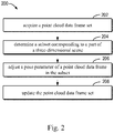
- Fig. 2 is a flowchart of a method 200 for reconstructing a three-dimensional scene according to some embodiments of the present disclosure.
- the method 200 may be performed by the computing device 104 shown in Fig. 1 .
- the computing device 104 may be a distributed computing device including a plurality of computing nodes.
- the computing device 104 acquires a point cloud data frame set for a three-dimensional scene, and point cloud data frames in the point cloud data frame set respectively have a pose parameter.
- the point cloud data frame set may be acquired by the collection entity on an urban road by means of a laser radar.
- the position and orientation of a sensor such as the laser radar may be referred to as the pose parameter corresponding to the point cloud data frame.
- the pose parameter may include six parameters such as coordinates and a pitch angle.
- the collection entity may further include a global navigation satellite system (GNSS) and/or an inertial measurement unit (IMU).
- GNSS includes a global positioning system (GPS), a Beidou system, a Galileo system, a GLONASS, etc.
- the computing device 104 determines a subset corresponding to a part of the three-dimensional scene from the point cloud data frame set.
- the three-dimensional scene may be divided into a plurality of parts, and each part corresponds to a corresponding point cloud data frame subset.
- different point cloud data frame subsets may be sent to different computing nodes, so that the different computing nodes process the point cloud data frame subsets in parallel, to improve the computational efficiency. Therefore, the problem that the cartographic optimization computation for the large-scale urban scene is time-consuming is effectively solved.
- a subset corresponding to a specific part of the scene may be determined, in various ways, from the point cloud data frame set.
- Fig. 3 is a flowchart of a method 300 for determining a point cloud data frame subset according to some embodiments of the present disclosure. The method 300 may be performed by the computing device 104 shown in Fig. 1 .
- the computing device 104 determines the position of the intersection in the three-dimensional scene based on a trajectory corresponding to the point cloud data frame set.
- the trajectory corresponding to the point cloud data frame set may be determined based on an initial pose of a point cloud data frame.
- the initial pose of the point cloud data frame may be determined by the global navigation satellite system (GNSS) and/or the inertial measurement unit (IMU).
- GNSS global navigation satellite system
- IMU inertial measurement unit
- there is a good GNSS signal at the initial position of the collection entity and the position of the collection entity may be accurately determined.
- the GNSS signal may be blocked and become weak or disappear, and the initial pose may be determined in the form of increments by the IMU.
- a plurality of collections for point cloud data may be performed on some roads, and thus, there may be a plurality of trajectories for these roads. Therefore, dilation may be performed on a trajectory image to merge a road corresponding to the plurality of trajectories into one line. For example, there may be 10 trajectories on one road, and the 10 trajectories may be merged into one line through the dilation.
- a corner point of the intersection may be determined through a corner point detection method. It should be appreciated by those skilled in the art that the corner point of the intersection may be determined using a corner point detection method currently known or developed in future. In this regard, the present disclosure is not limited herein.
- one or more corner points corresponding to one intersection may be detected. For example, 2 or 4 points may be detected at one intersection.
- the position of the intersection may be determined by clustering. The plane coordinates in the global coordinate system of this position may be back-calculated through the pixels of the image.
- a connection diagram connecting the intersection is formed based on the position of the intersection. For example, depending on the connectivity of the trajectories, the determined intersection may be connected to form the connection diagram of the intersection.
- a closed path is determined as the part of the three-dimensional scene based on the connection diagram. For example, through an extracted intersection and a sequence of the trajectories collected by the laser radar, the interconnectivity of the coordinates of the intersection is obtained, and various closed paths (also referred to as closed loops or loopbacks) are determined.
- various closed paths also referred to as closed loops or loopbacks
- a closed-loop detection may be performed during the stitching of point clouds, to reduce the drift of an error and improve the optimization accuracy. It should be appreciated by those skilled in the art that the closed-loop detection may be performed using any appropriate closed-loop detection method currently known or developed in future.
- a pose parameter of a point cloud data frame in the subset is adjusted to obtain an adjusted subset.
- the adjusted subset includes at least two point cloud data frames having matching overlapping parts.
- the point cloud data frames in the point cloud data frame subset may be stitched to reduce the ghosting of overlapping parts of the point cloud data frames.
- Fig. 4 is a flowchart of a method 400 for adjusting a pose parameter according to some embodiments of the present disclosure.
- the method 400 may be performed by the computing device 104.
- the method 400 may be performed by one computing node in the distributed computing device.
- Fig. 4 illustrates the method 400 including a plurality of sequential steps, one or more of these steps may be omitted and the sequence of these steps may be appropriately adjusted without departing from the scope of the present disclosure.
- the computing device 104 removes a data point associated with a dynamic object from the point cloud data frame in the point cloud data frame subset.
- the three-dimensional scene 102 may include a dynamic object, for example, the vehicle 118 and a pedestrian (not shown).
- a dynamic object may be considered as noise. Therefore, in order to eliminate the influence of the dynamic object, the data point representing a dynamic object may be first removed from the point cloud data frame.
- a dynamic object may be detected using a method based on a ground detection and a bounding box.
- the ground may be extracted from the point cloud data frame.
- the ground may be extracted using a method such as a random sample consensus (RANSAC) method and a plane fitting method.
- RANSAC random sample consensus
- the ground may be extracted using a method currently known or developed in future. In this regard, the present disclosure is not limited herein.
- the data points representing the ground may be removed from the point cloud data frame.
- non-ground data points may include a wall of a building, a plant (e.g., a tree), etc.
- the spatial distribution of these objects may present discreteness and discontinuity due to without the connection to the ground.
- the data points representing the objects may be divided into a plurality of groups by clustering, and each group may represent a corresponding object. For example, each vehicle, tree, etc. may be clustered into group, respectively.
- Dynamic object may be matched and extracted based on an attribute (e.g., geometric property) of the object such as the vehicle.
- the dynamic object may be matched and extracted by means of a bounding box.
- the vehicle may be detected using a bounding box matching the size (e.g., length, width and height) of the vehicle.
- the data points representing the dynamic object may be removed from the point cloud data frame and the data points representing the ground may be added.
- an error is generated during the stitching of the point clouds.
- the generation of the error may be reduced or eliminated by removing the data points representing the dynamic object from the point cloud data frame, thereby the matching accuracy and stability are improved.
- the processing on the dynamic object is described above in combination with the method based on the ground detection and the bounding box. However, it should be appreciated by those skilled in the art that the dynamic object may also be removed using other detection methods known or developed in future such as a rule based detection or a learning based detection.
- the computing device 104 may extract a static object from the point cloud data frame.
- the computing device 104 may extract a plane (the ground, the wall, etc.) and a pillar (a trunk, a street light, etc.) in the point cloud data frame, retaining only the data having highly-structured information, to improve a subsequent matching accuracy.
- the computing device 104 may extract a planar characteristic and/or a straight line characteristic.
- the plane such as the ground may be extracted using the point cloud library (PCL), and the pillar such as the trunk may be extracted using the region growing method.
- PCL point cloud library
- the static object may also be extracted using any appropriate method currently known or developed in future.
- the computing device 104 may adjust the pose parameter based on a characteristic distance between corresponding objects in point cloud data frames having an overlap. For example, if two point cloud data frames scans a common area, the two point cloud data frames may form the point cloud data frames having an overlap. For example, there is an overlap between a first point cloud data frame and a second point cloud data frame, a characteristic distance between corresponding objects in the first point cloud data frame and the second point cloud data frame may be determined, and the pose parameter is adjusted based on the characteristic distance.
- the object may be the planar characteristic (e.g., the ground or the wall) or the straight line characteristic (e.g., the trunk or the street light) determined at block 404.
- the characteristic distances between all of these objects in the point cloud data frame subset may be summed, and the pose parameter is adjusted by minimizing the sum of the characteristic distances.
- the least squares method may be used. It is appreciated by those skilled in the art that any appropriate method currently known or developed in the future may be adopted.
- point cloud data frames having an overlap with this point cloud data frame may include one or more point cloud data frames continuously collected in time, and point cloud data frames collected when this position(e.g., within a certain distance of the position) is passed through many times. Therefore, one point cloud data frame may be paired with a plurality of point cloud data frames.
- Optimizing the pose parameters of all of the point cloud data frames in the point cloud data frame subset together occupies a large amount of computation, and thus the situation where the processing is performed by a separate computing node is more advantageous.
- noise may be reduced, and the matching accuracy and the computational efficiency may be improved.
- the extracted plane and cylinder (the cylinder may be considered as a straight line passing through a center) may be expressed as f k ( c k , n k ).
- c k represents the coordinates of the center
- n k represents the normal vector of the plane or the direction of the straight line.
- the priori pose of the laser radar is p k
- two frames of laser point clouds are respectively M 1 and M 2 (including the extracted planar characteristic and the normal vector mentioned above).
- the purpose of matching the point clouds is to determine an optimal pose difference ⁇ p by matching M 1 and M 2 .
- corresponding characteristics e.g., the planar characteristic and/or the rectilinear characteristic
- a line-line distance and a plane-plane distance are calculated for these characteristics.
- the line-line distances and a plane-plane distances of all the point cloud data frames having overlapping areas are summed as an optimization target function, and the optimal pose difference ⁇ p is solved by minimizing the target function, as illustrated in formula (3): ⁇ p ⁇ argmin ⁇ p ⁇ j ⁇ i ⁇ k ⁇ ⁇ p ⁇ x k M i ⁇ x k M j ⁇ n i M j ⁇ 2 + ⁇ i ⁇ ⁇ p ⁇ x k M i ⁇ x k M j ⁇ n i M j ⁇ 2
- i and j represent two point cloud data frames and k represents a data point.
- the computing device 104 updates the point cloud data frame set using the adjusted subset. Since each part is optimized separately, the global pose adjustment is performed through the constraint of the co-participating pose. For example, the pose parameters of all of the point cloud data frames in the point cloud data frame subset may be optimized overall. Specifically, another part of the three-dimensional scene may be determined, and the another part overlaps this part of the three-dimensional scene. For example, two closed paths may have a partially overlapping path. For the another part of the three-dimensional scene, a point cloud data frame subset corresponding to the another part may be determined, which may have been processed by the method 300 shown at block 206 or in Fig. 3 . By adjusting the pose parameters of the point cloud data frames in the two subsets, the corresponding point cloud data frames in the overlapping part of the three-dimensional scene overlaps each other, or the pose parameters of the corresponding point cloud data frames are equal.
- each point cloud data frame subset there is a corresponding pose adjustment parameter, for example, rotation matrix A and translation vector b.
- a corresponding pose adjustment parameter for example, rotation matrix A and translation vector b.
- the pose parameters of the corresponding point cloud data frames should be equivalent due to the repeated use of the point cloud data frame.
- a i , b i , A j and b j respectively represent the rotation matrix and translation vector of the i th point cloud data frame subset and the rotation matrix and translation vector of the j th point cloud data frame subset
- S i and S j represent the pose of the i th point cloud data frame subset and the pose of the j th point cloud data frame subset.
- the pose of a point cloud data frame subset may be defined as the pose of one of the point cloud data frames, and the poses of other point cloud data frames in the subset may be understood as relative poses of the pose of the point cloud data frame.
- the pose of the point cloud data frame repeatedly used in the two scene parts may be defined as the pose of the corresponding subset.
- the pose of a good quality GNSS signal may be fixed to optimize the overall laser radar pose.
- the pose parameter of the point cloud data frame may deviate from the original pose parameter after being optimized at block 206, while the original pose parameter is determined through a GNSS signal having a high confidence level. Therefore, the pose parameter of this point cloud data frame may be amended as the original pose parameter, and the pose parameters of other point cloud data frames in the subset in which the point cloud data frame is included are adjusted in the same way. With the help of the GNSS signal having a high confidence level, the accuracy in stitching the point clouds may be further improved.
- Fig. 5 is a block diagram of an apparatus 500 for reconstructing a three-dimensional scene according to some embodiments of the present disclosure.
- the apparatus 500 may be included in the computing device 104 in Fig. 1 or implemented as the computing device 104.
- the apparatus 500 includes a point cloud acquiring module 502, configured to acquire a point cloud data frame set aiming at a three-dimensional scene, point cloud data frames in the point cloud data frame set respectively having a pose parameter.
- the apparatus 500 further includes a subset determining module 504, configured to determine a subset corresponding to a part of the three-dimensional scene from the point cloud data frame set.
- the apparatus 500 further includes a pose adjusting module 506, configured to adjust a pose parameter of a point cloud data frame in the subset to obtain an adjusted subset, the adjusted subset including at least two point cloud data frames having matching overlapping parts.
- the apparatus 500 further includes a point cloud updating module 508, configured to update the point cloud data frame set using the adjusted subset.
- the subset determining module 504 includes: an intersection determining module, configured to determine a position of an intersection in the three-dimensional scene based on a trajectory corresponding to the point cloud data frame set; a connection diagram forming module, configured to form a connection diagram of connecting the intersection based on the position of the intersection; and a part determining module, configured to determine a closed path as the part of the three-dimensional scene based on the connection diagram.
- the intersection determining module includes: a line determining module, configured to determine a line representing a road by dilating the trajectory; a corner point determining module, configured to determine at least one point at the intersection based on the line; and a position determining module, configured to determine the position of the intersection based on the at least one point at the intersection.
- the pose adjusting module 506 includes: a dynamic object removing module, configured to remove data points associated with a dynamic object from point cloud data frames in the subset, to update the subset; and a first pose parameter adjusting module, configured to adjust a pose parameter of a point cloud data frame in the updated subset.
- the dynamic object removing module includes: a ground removing module, configured to remove data points representing a ground from the point cloud data frames; a dynamic object recognizing module, configured to recognize the dynamic object in the point cloud data frames; a data point removing module, configured to remove data points representing the dynamic object from the point cloud data frames; and a ground adding module, configured to add data points representing the ground into the point cloud data frames.
- the dynamic object recognizing module includes: a clustering module, configured to cluster point cloud data in the point cloud data frames to determine a plurality of clusters in the point cloud data frames; and a matching module, configured to determine a cluster matching an attribute of the dynamic object from the plurality of clusters.
- the pose adjusting module 506 includes: data points extracting module, configured to extract data points representing a static object from a plurality of point cloud data frames, to update the subset; and adjusting a pose parameter of a point cloud data frame in the updated subset.
- the at least two point cloud data frames include a first point cloud data frame and a second point cloud data frame.
- the pose adjusting module 506 includes: a characteristic distance determining module, configured to determine a characteristic distance between corresponding objects in the first point cloud data frame and the second point cloud data frame; and a second pose parameter adjusting module, configured to adjust the pose parameter based on the characteristic distance.
- the point cloud updating module 508 includes: the part determining module, configured to determine another part of the three-dimensional scene, the another part overlapping the part of the three-dimensional scene; the subset determining module, configured to determine another subset corresponding to the another part of the three-dimensional scene from the point cloud data frame set; and a third pose parameter adjusting module, configured to adjust a pose parameter of a point cloud data frame in the subset and a pose parameter of a point cloud data frame in the another subset, to cause a third point cloud data frame in the subset to overlap a fourth point cloud data frame in the another subset.
- the point cloud updating module 508 includes: a pose parameter determining module, configured to determine a pose parameter of a fifth point cloud data frame in the part through a global navigation satellite system; and a point cloud data updating module, configured to update the point cloud data frame set based on the pose parameter of the fifth point cloud data frame.
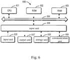
- Fig. 6 is schematic a block diagram of a device 600 which may be used to implement the embodiments of the present disclosure.
- the device 600 may be used to implement the computing device 104 in Fig. 1 .
- the computer system 600 includes a central processing unit (CPU) 601, which may execute various appropriate actions and processes in accordance with a program stored in a read-only memory (ROM) 602 or a program loaded into a random access memory (RAM) 603 from a storage portion 608.
- the RAM 603 also stores various programs and data required by operations of the system 600.
- the CPU 601, the ROM 602 and the RAM 603 are connected to each other through a bus 604.
- An input/output (I/O) interface 605 is also connected to the bus 604.
- a plurality of components in the device 600 are coupled to the I/O interface 605, including: an input unit 606, for example, a keyboard and a mouse; an output unit 607, for example, various types of displays and speakers; the storage unit 608, for example, a disk and an optical disk; and a communication unit 609, for example, a network card, a modem, or a wireless communication transceiver.
- the communication unit 609 allows the device 600 to exchange information/data with other devices over a computer network such as the Internet and/or various telecommunication networks.
- the processing and processes described above, for example, the methods 200-400 may be performed by the processing unit 601.
- the methods 200-400 may be implemented as computer software programs tangibly embodied in a machine readable medium, for example, the storage unit 608.
- some or all of the computer programs may be loaded and/or installed onto the device 600 via the ROM 602 and/or the communication unit 609.
- the CPU 601 may be configured to perform the methods 200-400 by any other suitable means (e.g., by means of firmware).
- the present disclosure may be a method, an apparatus, a system, and/or a computer program product.
- the computer program product may include a computer readable storage medium having computer readable program instructions for executing various aspects of the present disclosure.
- a computer readable storage medium may be a tangible device that may contain or store instructions for use by an instruction execution device.
- the computer readable storage medium may be, but not limited to, an electronic storage device, a magnetic storage device, an optical storage device, an electromagnetic storage device, a semiconductor storage device, or any suitable combination of the foregoing.
- the computer readable storage medium include: a portable computer disk, a hard disk, a random access memory (RAM), a read only memory (ROM), an erasable programmable read only memory (EPROM or flash memory), a static random access memory (SRAM), a portable compact disk read only memory (CD-ROM), a digital versatile disc (DVD), a memory stick, a floppy disk, , and any suitable combination of the foregoing.
- RAM random access memory
- ROM read only memory
- EPROM or flash memory erasable programmable read only memory
- SRAM static random access memory
- CD-ROM compact disk read only memory
- DVD digital versatile disc
- memory stick a floppy disk, and any suitable combination of the foregoing.
- the computer readable storage medium used herein is not interpreted as a transient signal itself, for example, a radio wave or other freely propagating electromagnetic waves, an electromagnetic wave propagating through a waveguide or other transmission media (e.g., a light pulse through a fiber optic cable), or an electrical signal transmitting through an electric wire.
- the computer readable program instruction described herein may be downloaded from the computer readable storage medium to various computing/processing devices, or downloaded to an external computer or external storage device through a network, for example, the Internet, a local area network, a wide area network and/or a wireless network.
- the network may include a copper transmission cable, a fiber optic transmission, a wireless transmission, a router, a firewall, a switch, a gateway computer, and/or an edge server.
- a network adapter card or network interface in each computing/processing device receives a computer readable program instruction from the network and forwards the computer readable program instruction to be stored into a computer readable storage medium in each computing/processing device.
- a computer program instruction for implementing the operations of the present disclosure may be an assembly instruction, an instruction set architecture (ISA) instruction, a machine instruction, a machine related instruction, a microcode, a firmware instruction, state setting data, or a source code or a target code written in any combination of one or more programming languages, including an object-oriented programming language (e.g., Smalltalk and C++) and a general procedural programming language (e.g., "C" language or a similar programming language).
- the computer readable program instruction may be executed entirely on a user computer, executed partially on the user computer, executed as a standalone software package, executed partially on the user computer and partially on a remote computer, or executed entirely on the remote computer or a server.
- the remote computer When the remote computer is involved, the remote computer may be connected to the user computer through any type of network, including the local area network (LAN) or the wide area network (WAN), or be connected to an external computer (e.g., connected through Internet provided by an Internet service provider).
- LAN local area network
- WAN wide area network
- an external computer e.g., connected through Internet provided by an Internet service provider.
- an electronic circuit is customized, for example, a programmable logic circuit, a field programmable gate array (FPGA) or a programmable logic array (PLA).
- the electronic circuit may execute the computer readable program instruction, thereby implementing the aspects of the present disclosure.
- These computer readable program instructions may be provided to a processing unit of a general purpose computer, a special purpose computer or other programmable data processing apparatuses, to produce a machine.
- an apparatus implementing a function/action defined in one or blocks in the flowcharts and/or the block diagrams is produced when theses instructions are executed by the processing unit of a computer or other programmable data processing apparatuses.
- These computer readable program instructions may also be stored into the computer readable storage medium, to cause the computer, the programmable data processing apparatuses and/or other devices to operate in a particular way. Therefore, the computer readable medium storing instructions includes a manufactured product, including instruction of various aspects implementing the function/action defined in one or blocks in the flowcharts and/or the block diagrams.
- the computer readable program instructions may also be loaded onto the computer, the other programmable data processing apparatuses or the other devices, to perform a series of operation steps on the computer, the other programmable data processing apparatuses or the other devices, to produce a computer implementation process.
- the instructions executed on the computer, the other programmable data processing apparatuses or the other devices implement the function/action defined in one or blocks in the flowcharts and/or the block diagrams.
- each of the blocks in the flowcharts or block diagrams may represent a module, a program segment, or an instruction portion, the module, the program segment, or the instruction portion comprising one or more executable instructions for implementing specified logic functions.
- the functions denoted by the blocks may occur in a sequence different from the sequences shown in the drawings. For example, any two blocks presented in succession may be executed, substantially in parallel, or they may sometimes be executed in a reverse sequence, depending on the function involved.
- each block in the block diagrams and/or flowcharts as well as a combination of blocks may be implemented using a dedicated hardware-based system executing specified functions or actions, or by a combination of dedicated hardware and computer instructions.
Landscapes
- Engineering & Computer Science (AREA)
- Physics & Mathematics (AREA)
- General Physics & Mathematics (AREA)
- Theoretical Computer Science (AREA)
- Computer Graphics (AREA)
- Computer Vision & Pattern Recognition (AREA)
- Geometry (AREA)
- Software Systems (AREA)
- Traffic Control Systems (AREA)
- Processing Or Creating Images (AREA)
- Image Analysis (AREA)
- Instructional Devices (AREA)
- Optical Radar Systems And Details Thereof (AREA)
- Control Of Driving Devices And Active Controlling Of Vehicle (AREA)
- Navigation (AREA)
- Image Generation (AREA)
Applications Claiming Priority (1)
| Application Number | Priority Date | Filing Date | Title |
|---|---|---|---|
| CN201810565152.4A CN108765487B (zh) | 2018-06-04 | 2018-06-04 | 重建三维场景的方法、装置、设备和计算机可读存储介质 |
Publications (3)
| Publication Number | Publication Date |
|---|---|
| EP3579188A2 true EP3579188A2 (fr) | 2019-12-11 |
| EP3579188A3 EP3579188A3 (fr) | 2020-03-25 |
| EP3579188B1 EP3579188B1 (fr) | 2022-05-11 |
Family
ID=64002592
Family Applications (1)
| Application Number | Title | Priority Date | Filing Date |
|---|---|---|---|
| EP19162888.2A Active EP3579188B1 (fr) | 2018-06-04 | 2019-03-14 | Procédé, appareil, dispositif et support d'informations lisible par ordinateur pour la reconstruction d'une scène tridimensionnelle |
Country Status (4)
| Country | Link |
|---|---|
| US (1) | US11080919B2 (fr) |
| EP (1) | EP3579188B1 (fr) |
| JP (1) | JP6771059B2 (fr) |
| CN (1) | CN108765487B (fr) |
Cited By (2)
| Publication number | Priority date | Publication date | Assignee | Title |
|---|---|---|---|---|
| KR20220041792A (ko) * | 2021-05-20 | 2022-04-01 | 베이징 바이두 넷컴 사이언스 앤 테크놀로지 코., 엘티디. | 라이다 점군 데이터 처리 방법, 장치, 기기, 저장매체 및 컴퓨터 프로그램 |
| CN115034000A (zh) * | 2022-05-13 | 2022-09-09 | 深圳模德宝科技有限公司 | 一种工艺设计的方法 |
Families Citing this family (61)
| Publication number | Priority date | Publication date | Assignee | Title |
|---|---|---|---|---|
| CN109271893B (zh) * | 2018-08-30 | 2021-01-01 | 百度在线网络技术(北京)有限公司 | 一种仿真点云数据的生成方法、装置、设备及存储介质 |
| US10839530B1 (en) * | 2018-09-04 | 2020-11-17 | Apple Inc. | Moving point detection |
| CN109903330B (zh) * | 2018-09-30 | 2021-06-01 | 华为技术有限公司 | 一种处理数据的方法和装置 |
| CN111327902B (zh) * | 2018-12-13 | 2022-11-22 | 华为技术有限公司 | 点云的编解码方法及装置 |
| CN113748314B (zh) * | 2018-12-28 | 2024-03-29 | 北京嘀嘀无限科技发展有限公司 | 交互式三维点云匹配 |
| US10955257B2 (en) | 2018-12-28 | 2021-03-23 | Beijing Didi Infinity Technology And Development Co., Ltd. | Interactive 3D point cloud matching |
| CN109657031B (zh) * | 2018-12-28 | 2020-08-04 | 国汽(北京)智能网联汽车研究院有限公司 | 一种基于智能网联汽车的高精度动态地图生成与应用方法 |
| CN109714421B (zh) * | 2018-12-28 | 2021-08-03 | 国汽(北京)智能网联汽车研究院有限公司 | 基于车路协同的智能网联汽车运行系统 |
| US11520331B2 (en) * | 2018-12-28 | 2022-12-06 | Intel Corporation | Methods and apparatus to update autonomous vehicle perspectives |
| CN110060322B (zh) * | 2019-03-11 | 2023-03-03 | 北京旷视科技有限公司 | 平面提取方法、装置、系统和存储介质 |
| EP3709272A1 (fr) * | 2019-03-15 | 2020-09-16 | InterDigital VC Holdings, Inc. | Traitement d'un nuage de points |
| CN110111374B (zh) * | 2019-04-29 | 2020-11-17 | 上海电机学院 | 基于分组阶梯式阈值判断的激光点云匹配方法 |
| WO2020232709A1 (fr) * | 2019-05-23 | 2020-11-26 | Beijing Didi Infinity Technology And Development Co., Ltd. | Procédé et système d'évaluation de la qualité d'une carte de nuage de points |
| CN110276317B (zh) * | 2019-06-26 | 2022-02-22 | Oppo广东移动通信有限公司 | 一种物体尺寸检测方法、物体尺寸检测装置及移动终端 |
| CN112747756B (zh) * | 2019-10-30 | 2023-04-07 | 北京地平线机器人技术研发有限公司 | 一种地图构建方法及装置 |
| US11521329B2 (en) * | 2019-11-22 | 2022-12-06 | Baidu Usa Llc | Updated point cloud registration pipeline based on ADMM algorithm for autonomous vehicles |
| CN110910493B (zh) * | 2019-11-29 | 2021-05-14 | 广州极飞科技股份有限公司 | 三维重建方法、装置及电子设备 |
| CN113359148B (zh) * | 2020-02-20 | 2024-05-28 | 百度在线网络技术(北京)有限公司 | 激光雷达点云数据处理方法、装置、设备及存储介质 |
| CN111311742B (zh) * | 2020-03-27 | 2023-05-05 | 阿波罗智能技术(北京)有限公司 | 三维重建方法、三维重建装置和电子设备 |
| CN111461981B (zh) * | 2020-03-30 | 2023-09-01 | 北京百度网讯科技有限公司 | 点云拼接算法的误差估计方法和装置 |
| CN111461980B (zh) * | 2020-03-30 | 2023-08-29 | 北京百度网讯科技有限公司 | 点云拼接算法的性能估计方法和装置 |
| CN111681163B (zh) * | 2020-04-23 | 2024-09-06 | 北京三快在线科技有限公司 | 构建点云地图的方法、装置、电子设备和存储介质 |
| CN112739983B (zh) * | 2020-04-24 | 2022-07-12 | 华为技术有限公司 | 校正点云数据的方法和相关装置 |
| CN111553975B (zh) * | 2020-04-27 | 2022-04-22 | 武汉易维晟医疗科技有限公司 | 一种手持式三维扫描系统的实时回环检测方法 |
| CN111553844B (zh) | 2020-04-29 | 2023-08-29 | 阿波罗智能技术(北京)有限公司 | 用于更新点云的方法及装置 |
| JP7448945B2 (ja) * | 2020-05-22 | 2024-03-13 | 国立大学法人金沢大学 | 3次元マップ生成方法及び3次元マップ生成装置 |
| CN113759369B (zh) * | 2020-06-28 | 2023-12-05 | 北京京东乾石科技有限公司 | 基于双多线雷达的建图方法和装置 |
| CN111968229B (zh) | 2020-06-28 | 2024-07-16 | 阿波罗智能技术(北京)有限公司 | 高精度地图制图方法及装置 |
| CN111833447A (zh) * | 2020-07-13 | 2020-10-27 | Oppo广东移动通信有限公司 | 三维地图构建方法、三维地图构建装置及终端设备 |
| CN112633437B (zh) * | 2020-07-23 | 2022-06-17 | 贵州酱酒智造供应链有限公司 | 一种基于工业互联的供应链管理方法 |
| CN114814872B (zh) * | 2020-08-17 | 2025-03-14 | 浙江商汤科技开发有限公司 | 位姿确定方法及装置、电子设备和存储介质 |
| CN112329547B (zh) * | 2020-10-15 | 2024-11-26 | 北京三快在线科技有限公司 | 一种数据处理方法及装置 |
| CN112258647B (zh) * | 2020-11-12 | 2024-04-02 | Oppo广东移动通信有限公司 | 地图重建方法及装置、计算机可读介质和电子设备 |
| CN112419414B (zh) * | 2020-12-07 | 2023-03-07 | 河南科技大学 | 一种获取奶畜乳房区域三维点云的装置 |
| CN114693865B (zh) * | 2020-12-29 | 2025-09-12 | 深圳引望智能技术有限公司 | 数据处理方法及相关装置 |
| CN114692256B (zh) * | 2020-12-30 | 2025-05-30 | 久瓴(江苏)数字智能科技有限公司 | 雨篷模型的构建方法、构建装置和计算机可读存储介质 |
| CN112767545A (zh) * | 2021-01-19 | 2021-05-07 | 西人马帝言(北京)科技有限公司 | 一种点云地图构建方法、装置、设备及计算机存储介质 |
| CN112704877B (zh) * | 2021-01-21 | 2022-05-24 | 博智安全科技股份有限公司 | 空中侦察的通视范围确定方法、终端设备和可读存储介质 |
| CN112837241B (zh) * | 2021-02-09 | 2025-01-10 | 贵州京邦达供应链科技有限公司 | 建图重影去除方法、设备及存储介质 |
| CN113066009B (zh) * | 2021-03-24 | 2023-08-25 | 北京斯年智驾科技有限公司 | 港口高精度地图集的构建方法、装置、系统和存储介质 |
| CN113077544A (zh) * | 2021-03-31 | 2021-07-06 | 商汤集团有限公司 | 一种点云生成的方法、装置、电子设备及存储介质 |
| CN113516772B (zh) * | 2021-06-30 | 2023-09-15 | 同济大学 | 三维场景重建方法及装置、bim模型的优化方法及装置 |
| CN115639904B (zh) * | 2021-07-20 | 2025-08-22 | 华为技术有限公司 | 一种基于人体姿态识别的对象控制方法和电子设备 |
| CN113568997B (zh) * | 2021-07-30 | 2025-02-21 | 京东鲲鹏(江苏)科技有限公司 | 点云地图更新方法、装置、电子设备和计算机可读介质 |
| CN113808216B (zh) * | 2021-08-31 | 2024-12-10 | 上海商汤临港智能科技有限公司 | 相机标定方法及装置、电子设备和存储介质 |
| CN113450457B (zh) * | 2021-08-31 | 2021-12-14 | 腾讯科技(深圳)有限公司 | 道路重建方法、装置、计算机设备和存储介质 |
| CN114241155B (zh) * | 2021-12-06 | 2025-01-07 | 电子科技大学长三角研究院(湖州) | 一种基于车载激光点云数据的城市树木三维可视化方法 |
| CN114690190A (zh) * | 2021-12-07 | 2022-07-01 | 广东工业大学 | 基于端边云协同的路侧激光雷达背景构建与更新方法 |
| CN113936085B (zh) * | 2021-12-17 | 2022-05-20 | 荣耀终端有限公司 | 三维重建方法和装置 |
| CN115018699B (zh) * | 2022-04-22 | 2026-04-14 | 高德软件有限公司 | 点云数据的过滤方法、装置、设备及介质 |
| CN114966793B (zh) * | 2022-05-25 | 2024-01-26 | 苏州天硕导航科技有限责任公司 | 三维测量系统、方法及gnss系统 |
| CN115015881B (zh) * | 2022-05-30 | 2024-10-22 | 西安电子科技大学 | 一种全向旋转的单线激光雷达装置及组网点云配准方法 |
| CN115423852B (zh) * | 2022-07-27 | 2026-04-17 | 浙江大华技术股份有限公司 | 一种点云数据配准方法、系统、电子设备及存储介质 |
| CN115439331B (zh) * | 2022-09-02 | 2023-07-07 | 北京百度网讯科技有限公司 | 角点的校正方法和元宇宙中三维模型的生成方法、装置 |
| CN115451977B (zh) * | 2022-09-06 | 2025-09-05 | 安徽蔚来智驾科技有限公司 | 车道标注数据的获取方法、计算机设备及存储介质 |
| CN115712298B (zh) * | 2022-10-25 | 2023-05-09 | 太原理工大学 | 基于单线激光雷达的机器人在通道中行驶的自主导航方法 |
| CN116070321A (zh) * | 2023-01-09 | 2023-05-05 | 武汉乡创科技有限公司 | 乡村景观设计方法、装置、设备及存储介质 |
| CN115984489B (zh) * | 2023-03-21 | 2023-09-19 | 广东数字生态科技有限责任公司 | 一种输电线路的三维重建方法、装置及处理设备 |
| CN116310262B (zh) * | 2023-05-23 | 2023-08-01 | 山东省国土测绘院 | 面状实体与倾斜三维模型融合方法、系统、介质及设备 |
| CN117824699B (zh) * | 2023-12-12 | 2024-08-27 | 中科南京智能技术研究院 | 一种基于帧间重叠区域点云的激光雷达里程计方法 |
| CN118823395A (zh) * | 2024-07-17 | 2024-10-22 | 华中科技大学 | 基于二次聚类的水下点云匹配方法、装置和电子设备 |
Family Cites Families (15)
| Publication number | Priority date | Publication date | Assignee | Title |
|---|---|---|---|---|
| CN102508257B (zh) * | 2011-09-27 | 2013-09-11 | 北京航空航天大学 | 一种车载移动测图装置的工作方法 |
| US9041914B2 (en) * | 2013-03-15 | 2015-05-26 | Faro Technologies, Inc. | Three-dimensional coordinate scanner and method of operation |
| US10078133B2 (en) * | 2014-08-15 | 2018-09-18 | Aeye, Inc. | Method and system for ladar transmission with closed loop feedback control of dynamic scan patterns |
| FR3033973A1 (fr) * | 2015-03-16 | 2016-09-23 | Univ Pierre Et Marie Curie Paris 6 | Procede de reconstruction 3d d'une scene |
| CN105069842A (zh) * | 2015-08-03 | 2015-11-18 | 百度在线网络技术(北京)有限公司 | 道路三维模型的建模方法和装置 |
| CN105139445B (zh) * | 2015-08-03 | 2018-02-13 | 百度在线网络技术(北京)有限公司 | 场景重建方法及装置 |
| WO2018060313A1 (fr) * | 2016-09-28 | 2018-04-05 | Tomtom Global Content B.V. | Procédés et systèmes de génération et d'utilisation de données de référence de localisation |
| KR102380216B1 (ko) * | 2016-11-29 | 2022-03-28 | 블랙모어 센서스 앤드 애널리틱스, 엘엘씨 | 포인트 클라우드 데이터 세트에서 객체의 분류를 위한 방법 및 시스템 |
| US10482340B2 (en) * | 2016-12-06 | 2019-11-19 | Samsung Electronics Co., Ltd. | System and method for object recognition and ranging by deformation of projected shapes in a multimodal vision and sensing system for autonomous devices |
| CN106846392A (zh) * | 2016-12-12 | 2017-06-13 | 国网北京市电力公司 | 三维建模的方法和装置 |
| CN107452062B (zh) * | 2017-07-25 | 2020-03-06 | 深圳市魔眼科技有限公司 | 三维模型构建方法、装置、移动终端、存储介质及设备 |
| US10509413B2 (en) * | 2017-09-07 | 2019-12-17 | GM Global Technology Operations LLC | Ground reference determination for autonomous vehicle operations |
| US10482628B2 (en) * | 2017-09-30 | 2019-11-19 | United States Of America As Represented By The Secretary Of The Army | Photogrammetric point cloud compression for tactical networks |
| JP7069927B2 (ja) | 2018-03-26 | 2022-05-18 | 株式会社デンソー | 物体認識装置、及び物体認識方法 |
| JP7093680B2 (ja) * | 2018-06-01 | 2022-06-30 | 日立Geニュークリア・エナジー株式会社 | 構造物差分抽出装置、構造物差分抽出方法およびプログラム |
-
2018
- 2018-06-04 CN CN201810565152.4A patent/CN108765487B/zh active Active
-
2019
- 2019-03-14 US US16/353,717 patent/US11080919B2/en active Active
- 2019-03-14 JP JP2019047110A patent/JP6771059B2/ja not_active Expired - Fee Related
- 2019-03-14 EP EP19162888.2A patent/EP3579188B1/fr active Active
Non-Patent Citations (1)
| Title |
|---|
| None |
Cited By (5)
| Publication number | Priority date | Publication date | Assignee | Title |
|---|---|---|---|---|
| KR20220041792A (ko) * | 2021-05-20 | 2022-04-01 | 베이징 바이두 넷컴 사이언스 앤 테크놀로지 코., 엘티디. | 라이다 점군 데이터 처리 방법, 장치, 기기, 저장매체 및 컴퓨터 프로그램 |
| EP4102254A1 (fr) * | 2021-05-20 | 2022-12-14 | Beijing Baidu Netcom Science And Technology Co., Ltd. | Procédé et dispositif de traitement de données de nuage de points radar, support d'enregistrement et produit-programme informatique |
| US11796670B2 (en) | 2021-05-20 | 2023-10-24 | Beijing Baidu Netcom Science And Technology Co., Ltd. | Radar point cloud data processing method and device, apparatus, and storage medium |
| CN115034000A (zh) * | 2022-05-13 | 2022-09-09 | 深圳模德宝科技有限公司 | 一种工艺设计的方法 |
| CN115034000B (zh) * | 2022-05-13 | 2023-12-26 | 深圳模德宝科技有限公司 | 一种工艺设计的方法 |
Also Published As
| Publication number | Publication date |
|---|---|
| JP6771059B2 (ja) | 2020-10-21 |
| US20190371044A1 (en) | 2019-12-05 |
| US11080919B2 (en) | 2021-08-03 |
| EP3579188A3 (fr) | 2020-03-25 |
| EP3579188B1 (fr) | 2022-05-11 |
| JP2019211466A (ja) | 2019-12-12 |
| CN108765487B (zh) | 2022-07-22 |
| CN108765487A (zh) | 2018-11-06 |
Similar Documents
| Publication | Publication Date | Title |
|---|---|---|
| US11080919B2 (en) | Method, apparatus, device and computer readable storage medium for reconstructing three-dimensional scene | |
| EP4116935B1 (fr) | Procédé et dispositif de création de carte à haute définition, et dispositif électronique | |
| US10878243B2 (en) | Method, device and apparatus for generating electronic map, storage medium, and acquisition entity | |
| JP7371111B2 (ja) | 自律走行車のナビゲーション用高精度地図を生成するためのポーズグラフの分散処理 | |
| JP7440005B2 (ja) | 高精細地図の作成方法、装置、デバイス及びコンピュータプログラム | |
| US11237004B2 (en) | Log trajectory estimation for globally consistent maps | |
| US11105638B2 (en) | Method, apparatus, and computer readable storage medium for updating electronic map | |
| US11790542B2 (en) | Mapping and localization system for autonomous vehicles | |
| KR102068419B1 (ko) | 포인트 클라우드 데이터 수집 궤적을 조정하기 위한 방법, 장치 및 컴퓨터 판독 가능한 매체 | |
| CN113177974B (zh) | 一种点云配准方法、装置、电子设备及存储介质 | |
| Chen et al. | Improved-UWB/LiDAR-SLAM tightly coupled positioning system with NLOS identification using a LiDAR point cloud in GNSS-denied environments | |
| US11100667B2 (en) | Systems and methods for generating annotations of structured, static objects in aerial imagery using geometric transfer learning and probabilistic localization | |
| WO2020041668A1 (fr) | Navigation inertielle assistée par signaux d'opportunité | |
| KR102677731B1 (ko) | GNSS/INS와 HD Map를 이용한 단안카메라의 위치측정 및 맵핑 처리를 향상시키기 위한 시스템 및 방법 | |
| US20220020177A1 (en) | Overhead View Image Generation | |
| Zhang et al. | Tightly coupled integration of vector HD map, LiDAR, GNSS, and INS for precise vehicle navigation in GNSS-challenging environment | |
| CN116772834A (zh) | 一种室外空旷场景的自动巡检机器人的建图与定位方法 | |
| Xia et al. | Bayesian simultaneous localization and multi-lane tracking using onboard sensors and a sd map | |
| Yadav et al. | Developing basic design and mathematical framework for a mobile mapping system—a case study using available sensors | |
| CN113129422A (zh) | 一种三维模型构建方法、装置、存储介质和计算机设备 | |
| Sari et al. | 3D mapping based-on integration of UAV platform and ground surveying | |
| CN120765433A (zh) | 一种基于数字孪生的园区智能巡检方法及系统 | |
| CN115239899B (zh) | 位姿图生成方法、高精地图生成方法和装置 | |
| JP7308772B2 (ja) | データ処理装置、データ処理方法及びデータ処理プログラム | |
| JP2024080881A (ja) | 自己位置推定装置、自己位置推定方法および自己位置推定プログラム |
Legal Events
| Date | Code | Title | Description |
|---|---|---|---|
| PUAI | Public reference made under article 153(3) epc to a published international application that has entered the european phase |
Free format text: ORIGINAL CODE: 0009012 |
|
| STAA | Information on the status of an ep patent application or granted ep patent |
Free format text: STATUS: REQUEST FOR EXAMINATION WAS MADE |
|
| 17P | Request for examination filed |
Effective date: 20190314 |
|
| AK | Designated contracting states |
Kind code of ref document: A2 Designated state(s): AL AT BE BG CH CY CZ DE DK EE ES FI FR GB GR HR HU IE IS IT LI LT LU LV MC MK MT NL NO PL PT RO RS SE SI SK SM TR |
|
| AX | Request for extension of the european patent |
Extension state: BA ME |
|
| PUAL | Search report despatched |
Free format text: ORIGINAL CODE: 0009013 |
|
| AK | Designated contracting states |
Kind code of ref document: A3 Designated state(s): AL AT BE BG CH CY CZ DE DK EE ES FI FR GB GR HR HU IE IS IT LI LT LU LV MC MK MT NL NO PL PT RO RS SE SI SK SM TR |
|
| AX | Request for extension of the european patent |
Extension state: BA ME |
|
| RIC1 | Information provided on ipc code assigned before grant |
Ipc: G06T 17/00 20060101ALI20200219BHEP Ipc: G06T 7/38 20170101AFI20200219BHEP |
|
| STAA | Information on the status of an ep patent application or granted ep patent |
Free format text: STATUS: EXAMINATION IS IN PROGRESS |
|
| 17Q | First examination report despatched |
Effective date: 20201218 |
|
| RAP1 | Party data changed (applicant data changed or rights of an application transferred) |
Owner name: APOLLO INTELLIGENT DRIVING TECHNOLOGY (BEIJING) CO., LTD. |
|
| GRAP | Despatch of communication of intention to grant a patent |
Free format text: ORIGINAL CODE: EPIDOSNIGR1 |
|
| INTG | Intention to grant announced |
Effective date: 20220302 |
|
| GRAS | Grant fee paid |
Free format text: ORIGINAL CODE: EPIDOSNIGR3 |
|
| STAA | Information on the status of an ep patent application or granted ep patent |
Free format text: STATUS: GRANT OF PATENT IS INTENDED |
|
| GRAA | (expected) grant |
Free format text: ORIGINAL CODE: 0009210 |
|
| STAA | Information on the status of an ep patent application or granted ep patent |
Free format text: STATUS: THE PATENT HAS BEEN GRANTED |
|
| AK | Designated contracting states |
Kind code of ref document: B1 Designated state(s): AL AT BE BG CH CY CZ DE DK EE ES FI FR GB GR HR HU IE IS IT LI LT LU LV MC MK MT NL NO PL PT RO RS SE SI SK SM TR |
|
| REG | Reference to a national code |
Ref country code: GB Ref legal event code: FG4D |
|
| REG | Reference to a national code |
Ref country code: CH Ref legal event code: EP |
|
| REG | Reference to a national code |
Ref country code: AT Ref legal event code: REF Ref document number: 1492101 Country of ref document: AT Kind code of ref document: T Effective date: 20220515 |
|
| REG | Reference to a national code |
Ref country code: DE Ref legal event code: R096 Ref document number: 602019014725 Country of ref document: DE |
|
| REG | Reference to a national code |
Ref country code: IE Ref legal event code: FG4D |
|
| GRAP | Despatch of communication of intention to grant a patent |
Free format text: ORIGINAL CODE: EPIDOSNIGR1 |
|
| REG | Reference to a national code |
Ref country code: LT Ref legal event code: MG9D |
|
| REG | Reference to a national code |
Ref country code: NL Ref legal event code: MP Effective date: 20220511 |
|
| REG | Reference to a national code |
Ref country code: NO Ref legal event code: T2 Effective date: 20220511 |
|
| REG | Reference to a national code |
Ref country code: AT Ref legal event code: MK05 Ref document number: 1492101 Country of ref document: AT Kind code of ref document: T Effective date: 20220511 |
|
| PG25 | Lapsed in a contracting state [announced via postgrant information from national office to epo] |
Ref country code: SE Free format text: LAPSE BECAUSE OF FAILURE TO SUBMIT A TRANSLATION OF THE DESCRIPTION OR TO PAY THE FEE WITHIN THE PRESCRIBED TIME-LIMIT Effective date: 20220511 Ref country code: PT Free format text: LAPSE BECAUSE OF FAILURE TO SUBMIT A TRANSLATION OF THE DESCRIPTION OR TO PAY THE FEE WITHIN THE PRESCRIBED TIME-LIMIT Effective date: 20220912 Ref country code: NL Free format text: LAPSE BECAUSE OF FAILURE TO SUBMIT A TRANSLATION OF THE DESCRIPTION OR TO PAY THE FEE WITHIN THE PRESCRIBED TIME-LIMIT Effective date: 20220511 Ref country code: LT Free format text: LAPSE BECAUSE OF FAILURE TO SUBMIT A TRANSLATION OF THE DESCRIPTION OR TO PAY THE FEE WITHIN THE PRESCRIBED TIME-LIMIT Effective date: 20220511 Ref country code: HR Free format text: LAPSE BECAUSE OF FAILURE TO SUBMIT A TRANSLATION OF THE DESCRIPTION OR TO PAY THE FEE WITHIN THE PRESCRIBED TIME-LIMIT Effective date: 20220511 Ref country code: GR Free format text: LAPSE BECAUSE OF FAILURE TO SUBMIT A TRANSLATION OF THE DESCRIPTION OR TO PAY THE FEE WITHIN THE PRESCRIBED TIME-LIMIT Effective date: 20220812 Ref country code: FI Free format text: LAPSE BECAUSE OF FAILURE TO SUBMIT A TRANSLATION OF THE DESCRIPTION OR TO PAY THE FEE WITHIN THE PRESCRIBED TIME-LIMIT Effective date: 20220511 Ref country code: ES Free format text: LAPSE BECAUSE OF FAILURE TO SUBMIT A TRANSLATION OF THE DESCRIPTION OR TO PAY THE FEE WITHIN THE PRESCRIBED TIME-LIMIT Effective date: 20220511 Ref country code: BG Free format text: LAPSE BECAUSE OF FAILURE TO SUBMIT A TRANSLATION OF THE DESCRIPTION OR TO PAY THE FEE WITHIN THE PRESCRIBED TIME-LIMIT Effective date: 20220811 Ref country code: AT Free format text: LAPSE BECAUSE OF FAILURE TO SUBMIT A TRANSLATION OF THE DESCRIPTION OR TO PAY THE FEE WITHIN THE PRESCRIBED TIME-LIMIT Effective date: 20220511 |
|
| PG25 | Lapsed in a contracting state [announced via postgrant information from national office to epo] |
Ref country code: RS Free format text: LAPSE BECAUSE OF FAILURE TO SUBMIT A TRANSLATION OF THE DESCRIPTION OR TO PAY THE FEE WITHIN THE PRESCRIBED TIME-LIMIT Effective date: 20220511 Ref country code: PL Free format text: LAPSE BECAUSE OF FAILURE TO SUBMIT A TRANSLATION OF THE DESCRIPTION OR TO PAY THE FEE WITHIN THE PRESCRIBED TIME-LIMIT Effective date: 20220511 Ref country code: LV Free format text: LAPSE BECAUSE OF FAILURE TO SUBMIT A TRANSLATION OF THE DESCRIPTION OR TO PAY THE FEE WITHIN THE PRESCRIBED TIME-LIMIT Effective date: 20220511 Ref country code: IS Free format text: LAPSE BECAUSE OF FAILURE TO SUBMIT A TRANSLATION OF THE DESCRIPTION OR TO PAY THE FEE WITHIN THE PRESCRIBED TIME-LIMIT Effective date: 20220911 |
|
| PG25 | Lapsed in a contracting state [announced via postgrant information from national office to epo] |
Ref country code: SM Free format text: LAPSE BECAUSE OF FAILURE TO SUBMIT A TRANSLATION OF THE DESCRIPTION OR TO PAY THE FEE WITHIN THE PRESCRIBED TIME-LIMIT Effective date: 20220511 Ref country code: SK Free format text: LAPSE BECAUSE OF FAILURE TO SUBMIT A TRANSLATION OF THE DESCRIPTION OR TO PAY THE FEE WITHIN THE PRESCRIBED TIME-LIMIT Effective date: 20220511 Ref country code: RO Free format text: LAPSE BECAUSE OF FAILURE TO SUBMIT A TRANSLATION OF THE DESCRIPTION OR TO PAY THE FEE WITHIN THE PRESCRIBED TIME-LIMIT Effective date: 20220511 Ref country code: EE Free format text: LAPSE BECAUSE OF FAILURE TO SUBMIT A TRANSLATION OF THE DESCRIPTION OR TO PAY THE FEE WITHIN THE PRESCRIBED TIME-LIMIT Effective date: 20220511 Ref country code: DK Free format text: LAPSE BECAUSE OF FAILURE TO SUBMIT A TRANSLATION OF THE DESCRIPTION OR TO PAY THE FEE WITHIN THE PRESCRIBED TIME-LIMIT Effective date: 20220511 Ref country code: CZ Free format text: LAPSE BECAUSE OF FAILURE TO SUBMIT A TRANSLATION OF THE DESCRIPTION OR TO PAY THE FEE WITHIN THE PRESCRIBED TIME-LIMIT Effective date: 20220511 |
|
| REG | Reference to a national code |
Ref country code: DE Ref legal event code: R097 Ref document number: 602019014725 Country of ref document: DE |
|
| PLBE | No opposition filed within time limit |
Free format text: ORIGINAL CODE: 0009261 |
|
| STAA | Information on the status of an ep patent application or granted ep patent |
Free format text: STATUS: NO OPPOSITION FILED WITHIN TIME LIMIT |
|
| PG25 | Lapsed in a contracting state [announced via postgrant information from national office to epo] |
Ref country code: AL Free format text: LAPSE BECAUSE OF FAILURE TO SUBMIT A TRANSLATION OF THE DESCRIPTION OR TO PAY THE FEE WITHIN THE PRESCRIBED TIME-LIMIT Effective date: 20220511 |
|
| 26N | No opposition filed |
Effective date: 20230214 |
|
| PG25 | Lapsed in a contracting state [announced via postgrant information from national office to epo] |
Ref country code: SI Free format text: LAPSE BECAUSE OF FAILURE TO SUBMIT A TRANSLATION OF THE DESCRIPTION OR TO PAY THE FEE WITHIN THE PRESCRIBED TIME-LIMIT Effective date: 20220511 |
|
| P01 | Opt-out of the competence of the unified patent court (upc) registered |
Effective date: 20230526 |
|
| PG25 | Lapsed in a contracting state [announced via postgrant information from national office to epo] |
Ref country code: MC Free format text: LAPSE BECAUSE OF FAILURE TO SUBMIT A TRANSLATION OF THE DESCRIPTION OR TO PAY THE FEE WITHIN THE PRESCRIBED TIME-LIMIT Effective date: 20220511 |
|
| REG | Reference to a national code |
Ref country code: BE Ref legal event code: MM Effective date: 20230331 |
|
| PG25 | Lapsed in a contracting state [announced via postgrant information from national office to epo] |
Ref country code: LU Free format text: LAPSE BECAUSE OF NON-PAYMENT OF DUE FEES Effective date: 20230314 |
|
| REG | Reference to a national code |
Ref country code: IE Ref legal event code: MM4A |
|
| PG25 | Lapsed in a contracting state [announced via postgrant information from national office to epo] |
Ref country code: IT Free format text: LAPSE BECAUSE OF FAILURE TO SUBMIT A TRANSLATION OF THE DESCRIPTION OR TO PAY THE FEE WITHIN THE PRESCRIBED TIME-LIMIT Effective date: 20220511 Ref country code: IE Free format text: LAPSE BECAUSE OF NON-PAYMENT OF DUE FEES Effective date: 20230314 |
|
| PG25 | Lapsed in a contracting state [announced via postgrant information from national office to epo] |
Ref country code: BE Free format text: LAPSE BECAUSE OF NON-PAYMENT OF DUE FEES Effective date: 20230331 |
|
| PGFP | Annual fee paid to national office [announced via postgrant information from national office to epo] |
Ref country code: CH Payment date: 20240401 Year of fee payment: 6 |
|
| PG25 | Lapsed in a contracting state [announced via postgrant information from national office to epo] |
Ref country code: BG Free format text: LAPSE BECAUSE OF FAILURE TO SUBMIT A TRANSLATION OF THE DESCRIPTION OR TO PAY THE FEE WITHIN THE PRESCRIBED TIME-LIMIT Effective date: 20220511 |
|
| PG25 | Lapsed in a contracting state [announced via postgrant information from national office to epo] |
Ref country code: BG Free format text: LAPSE BECAUSE OF FAILURE TO SUBMIT A TRANSLATION OF THE DESCRIPTION OR TO PAY THE FEE WITHIN THE PRESCRIBED TIME-LIMIT Effective date: 20220511 |
|
| PG25 | Lapsed in a contracting state [announced via postgrant information from national office to epo] |
Ref country code: CY Free format text: LAPSE BECAUSE OF FAILURE TO SUBMIT A TRANSLATION OF THE DESCRIPTION OR TO PAY THE FEE WITHIN THE PRESCRIBED TIME-LIMIT; INVALID AB INITIO Effective date: 20190314 |
|
| PG25 | Lapsed in a contracting state [announced via postgrant information from national office to epo] |
Ref country code: HU Free format text: LAPSE BECAUSE OF FAILURE TO SUBMIT A TRANSLATION OF THE DESCRIPTION OR TO PAY THE FEE WITHIN THE PRESCRIBED TIME-LIMIT; INVALID AB INITIO Effective date: 20190314 |
|
| REG | Reference to a national code |
Ref country code: CH Ref legal event code: H13 Free format text: ST27 STATUS EVENT CODE: U-0-0-H10-H13 (AS PROVIDED BY THE NATIONAL OFFICE) Effective date: 20251024 |
|
| PG25 | Lapsed in a contracting state [announced via postgrant information from national office to epo] |
Ref country code: TR Free format text: LAPSE BECAUSE OF FAILURE TO SUBMIT A TRANSLATION OF THE DESCRIPTION OR TO PAY THE FEE WITHIN THE PRESCRIBED TIME-LIMIT Effective date: 20220511 |
|
| PG25 | Lapsed in a contracting state [announced via postgrant information from national office to epo] |
Ref country code: CH Free format text: LAPSE BECAUSE OF NON-PAYMENT OF DUE FEES Effective date: 20250331 |
|
| PGFP | Annual fee paid to national office [announced via postgrant information from national office to epo] |
Ref country code: GB Payment date: 20260203 Year of fee payment: 8 |
|
| PGFP | Annual fee paid to national office [announced via postgrant information from national office to epo] |
Ref country code: NO Payment date: 20260206 Year of fee payment: 8 Ref country code: DE Payment date: 20260320 Year of fee payment: 8 |
|
| PGFP | Annual fee paid to national office [announced via postgrant information from national office to epo] |
Ref country code: FR Payment date: 20260213 Year of fee payment: 8 |