EP3608852A1 - Détermination d'une ou d'une pluralité de valeurs caractéristiques ainsi que simulation de la circulation pour un environnement praticable automatique - Google Patents
Détermination d'une ou d'une pluralité de valeurs caractéristiques ainsi que simulation de la circulation pour un environnement praticable automatique Download PDFInfo
- Publication number
- EP3608852A1 EP3608852A1 EP19190343.4A EP19190343A EP3608852A1 EP 3608852 A1 EP3608852 A1 EP 3608852A1 EP 19190343 A EP19190343 A EP 19190343A EP 3608852 A1 EP3608852 A1 EP 3608852A1
- Authority
- EP
- European Patent Office
- Prior art keywords
- parameters
- simulation
- environment
- traffic
- vehicles
- Prior art date
- Legal status (The legal status is an assumption and is not a legal conclusion. Google has not performed a legal analysis and makes no representation as to the accuracy of the status listed.)
- Granted
Links
Images




Classifications
-
- G—PHYSICS
- G06—COMPUTING OR CALCULATING; COUNTING
- G06Q—INFORMATION AND COMMUNICATION TECHNOLOGY [ICT] SPECIALLY ADAPTED FOR ADMINISTRATIVE, COMMERCIAL, FINANCIAL, MANAGERIAL OR SUPERVISORY PURPOSES; SYSTEMS OR METHODS SPECIALLY ADAPTED FOR ADMINISTRATIVE, COMMERCIAL, FINANCIAL, MANAGERIAL OR SUPERVISORY PURPOSES, NOT OTHERWISE PROVIDED FOR
- G06Q10/00—Administration; Management
- G06Q10/08—Logistics, e.g. warehousing, loading or distribution; Inventory or stock management
-
- G—PHYSICS
- G06—COMPUTING OR CALCULATING; COUNTING
- G06F—ELECTRIC DIGITAL DATA PROCESSING
- G06F30/00—Computer-aided design [CAD]
- G06F30/20—Design optimisation, verification or simulation
-
- G—PHYSICS
- G05—CONTROLLING; REGULATING
- G05D—SYSTEMS FOR CONTROLLING OR REGULATING NON-ELECTRIC VARIABLES
- G05D1/00—Control of position, course, altitude or attitude of land, water, air or space vehicles, e.g. using automatic pilots
- G05D1/0088—Control of position, course, altitude or attitude of land, water, air or space vehicles, e.g. using automatic pilots characterized by the autonomous decision making process, e.g. artificial intelligence, predefined behaviours
Definitions
- the invention relates to a method and a device for determining one or more characteristic values for an environment that can be automatically driven by vehicles.
- the invention also relates to a method for simulating traffic for an environment that can be automatically driven by vehicles, in particular in or for a method of the type specified above.
- a warehouse within which driverless vehicles transport, pick up, deposit, lay down, rearrange and bring them into and out of the warehouse.
- the transport can take place primarily in the plane (preferably horizontally and evenly, assumed as the x-y plane), but can also take place vertically (z direction), for example by means of an automatic forklift or the like.
- Such properties can be comparatively large and have many 1,000 to several 10,000 square meters of floor space.
- Many automatically driving vehicles can be in them.
- Another example is the movement of a robot or robot arm in an environment.
- the robot arm is then the vehicle, and the environment has various other objects, such as a product to be manufactured, a small goods warehouse, another (movable) robot arm, one or more people, other stationary or movable obstacles and the like.
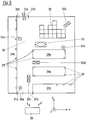
- Fig. 3 schematically shows a possible constellation in plan view.
- a storage room with an accessible surface 36 is assumed.
- Passable gates are indicated by 37a and 37b.
- 38a and 38b doors for people are indicated.
- Structures 34a, 34b, 34c and 34d are stationary shelves for the storage of goods.
- 35 indicates a free warehouse, i.e. areas on which goods can be placed freely and which are passable or not passable depending on the occupancy status.
- active and / or passive navigation aids are designated, which serve the navigation and the orientation of the automatically driving vehicles 32.
- These can be passive reflectors for optical detection or active sensors which can detect the surroundings in two or three dimensions and can transmit their detection results to a central computer 30 in a wireless or wired manner.
- This computer 30 is in turn connected to the automatically driving vehicles 32.
- communication between navigation aids 39 and automatic vehicles 32 can also take place wirelessly.
- Passive navigation aids can be attached to obstacles (for example on shelves 34) or can also be passable markings on the floor.
- Fig. 3 shows four automatic vehicles 32a, 32b, 32c and 32d.
- 33 denotes a vehicle conventionally driven by a person, such as a forklift or a bicycle or the like.
- 31a-c denotes people who can stay in the camp.
- the automatically moving vehicles 32 bring goods from the outside into the warehouse and place them there on a shelf 34 or on the open space 35, and / or pick up goods from there and take them out of the warehouse, and / or carry out redeployment within the warehouse or simple passages.
- the vehicles 32 are equipped with various sensors and other control devices.
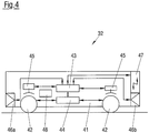
- Fig. 4 shows this systematically.
- a central control is indicated there with 43, which receives signals from sensor system 46a, 46b and emits them to actuator system 44, 45.
- the controller 43 is connected to a wireless communication link 47, by means of which it can communicate with other vehicles or with a central computer 30.
- the actuator system can have the vehicle drive 44 and / or brakes 45 and / or steering and the like.
- the sensor system can have internal sensors (speed sensor, acceleration sensor, ...) and environment sensors that can scan and record the surroundings around the vehicle in two or three dimensions.
- the environmental sensor system described can be a spatially resolving distance sensor system which makes it possible to detect the environment, for example by means of LIDAR (Light Detection and Ranging) or LADAR (Laser Detection and Ranging), or to the extent that the spatial resolution of this sensor system can be comparatively fine and are in the range of one centimeter or less centimeters.
- LIDAR Light Detection and Ranging
- LADAR Laser Detection and Ranging
- Automatic driving in an environment takes place with reference to an electronically usable representation of the environment, which represents the environment in a spatially resolved or spatially resolved manner.
- a representation is also referred to in the following as "card” or "electronic card”.
- the situation of the Fig. 3 could be such an environmental representation / map / electronic map at least store the floor plan, the shelves 34 therein, the positions of the gates 37 and doors 38 and, if necessary, also the positions of the navigation aids 39.
- the spatial resolution of the map corresponds to the requirements and can be in the centimeter or millimeter range.
- the surroundings of a robot arm can also be mapped as described.
- an initial state or a current state in the environment to be simulated can be taken and further recursively / iteratively calculated in many time-discrete steps.
- the current state can be described on the one hand by the electronic card and on the other hand by data that describe the behavior of mobile objects and other objects in the environment. Specifically, data tuples of position and orientation, linear speed, angular speed, linear acceleration, angular acceleration, size and other data can exist for each automatic vehicle 32, for each guided vehicle 33 and for each pedestrian 31.
- the simulation can be carried out iteratively, that is to say that a calculated final state is taken as the new initial state and is calculated from there until an internal or external termination criterion for the simulation is present.
- simulated interventions can occur, for example by changing simulated steering angles or by simulated detections indicating an approach to another object that requires an intervention.
- the simulation captures the normal physical dynamics of moving bodies on the one hand, but on the other hand also interventions that are necessary to execute orders and to ensure the safety of automatic driving.
- the simulation therefore also includes safety-relevant aspects such as collision prevention and thus also sensor simulation, actuator simulation and the like. This all depends on various parameters.
- an electronic map is first provided.
- parameters are provided which describe the properties of vehicles to be simulated and the properties to be simulated of the total traffic to be simulated in the area.
- the traffic in the area is simulated.
- events of interest are recorded and counted the same.
- the desired characteristic values are determined which are last saved and / or output.
- the determined characteristic values can be an environmental assessment and / or driving parameters for vehicles, such as parameter definitions such as e.g. B. protective and warning field definitions or hardware equipment of a vehicle, and / or changes to the electronic map, which can be understood as a proposal to change the real environment.
- parameter definitions such as e.g. B. protective and warning field definitions or hardware equipment of a vehicle
- changes to the electronic map which can be understood as a proposal to change the real environment.
- One type of characteristic value determination can be to generate, if necessary, location-resolving, environment-describing evaluation numbers in order to have a characteristic for the environment. Counter values alone can be sufficient for this. However, it is also possible to generate relative or related values, such as the values referred to a (simulated) year and a vehicle. For example, if ten years of operation with 100 vehicles (i.e. 1,000 vehicle years) were simulated and three personal injuries were recorded, this leads to a key figure of 0.003 personal injuries per vehicle and year.
- characteristic values can be generated, such as relative personal injury frequency, relative property damage frequency, relative frequency of critical situations and the like.
- the characteristic values for describing the automatically navigable environment are then a data tuple of several numbers which preferably represent relative characteristic values and which provide an absolutely usable and relatively well comparable reference for the environmental properties represented thereby.
- the simulation can be a discrete-time, step-by-step simulation of the movement of the individual objects, including automatic vehicles, driver-guided vehicles and pedestrians.
- the timing (step size on the time axis) can be in the range of seconds or tenths of a second.
- the "acceleration" of the simulated traffic compared to real traffic depends strongly on the computer power involved and on the size of the environment to be simulated or the number of vehicles / people to be simulated. However, it can be assumed that the simulation can be accelerated by a factor of 100,000 compared to reality. This means that a real day (with 86,400 seconds) can be simulated in less than a second and that, for example, a whole year of traffic can be simulated in about five minutes. Ten years of traffic can then be simulated in under an hour. Statistically significant values can then be generated over such a long, simulated period of time, especially in the simulation firstly count values of events of interest.
- Automatic driving in the sense of this description can mean that a vehicle is driving remotely, that is, it receives its dynamic commands (braking, accelerating, steering, constantly moving, ...) from a remote location (e.g. central control) , preferably wireless and in accordance with data that describe in real time the current situation in the traffic environment. This data may have been recorded and forwarded by the vehicle itself and / or may come from other data sources. It can also mean that a vehicle drives autonomously, i.e. drives to a destination independently, and generates its own dynamic-related commands in accordance with the data mentioned. Automatic driving can also be a hybrid of remote-controlled and autonomous driving. It can be without a driver or with a supervising person.
- Species can be, for example, unimpeded traffic, slow-moving traffic, traffic jams, critical situations without damage, property damage, personal injury, protective field violation, warning field violation, the creation of crushing points, drawing up plans, changing plans and the like.
- Pinch points are places where the distance between any part of the vehicle and a surrounding object falls below a certain predefined minimum (about 40 cm or 30 cm), so that there would probably be crushing if there were a person.
- a certain predefined minimum about 40 cm or 30 cm
- Unobstructed, slow-moving traffic or traffic jams can be differentiated using speed ranges, for example.
- the counting of events of interests can be event-controlled (for example when a simulated collision is identified as material damage) or time-controlled (for example once per second) or path-controlled (for example once per meter) or position-controlled.
- the events of interest are recorded in the simulation by suitable evaluation algorithms evaluating the respective data of the simulated movements.
- the counts are then incremented separately for the type of event of interest. Naturally, they can reach significantly different meter readings (unimpeded traffic high, slow-moving traffic, traffic jams less high, order creation high according to traffic volume, order change low, critical situation / fast damage, vehicle damage, personal injury low).
- the count values can then be processed further to the desired characteristic values or serve as a termination criterion for a simulation and / or can be used as an evaluation of one or more parameters of the simulation.
- the simulation is based on at least vehicle parameters and traffic parameters.
- Vehicle parameters can include equipment parameters of a vehicle and dynamic parameters of a vehicle. All of these parameters are included in the simulation by simulating their effects on vehicle movement.
- the equipment parameters of a vehicle can include sensor properties, possibly with associated error probabilities, in particular redundancy of the sensor system and spatial resolution of the sensor system, actuator properties, optionally with associated error probabilities, in particular steering behavior, braking behavior, acceleration behavior, control properties, possibly with associated error probability, in particular redundancy of the control, error frequency, Communication properties, possibly with associated error probabilities, in particular device redundancy, connection stability, connection quality, connection speed.
- sensor properties possibly with associated error probabilities, in particular redundancy of the sensor system and spatial resolution of the sensor system
- actuator properties optionally with associated error probabilities, in particular steering behavior, braking behavior, acceleration behavior
- control properties possibly with associated error probability, in particular redundancy of the control, error frequency
- Communication properties possibly with associated error probabilities, in particular device redundancy, connection stability, connection quality, connection speed.
- the breakdown of communication with other vehicles or with a central control (simulated) can lead to a (simulated) slowdown or plan change or the like, in order to simulate fail-save behavior, for example.
- Dynamic parameters of a vehicle can be set maximum speed values, set maximum acceleration values (positive and negative - braking), distance values to moving and immovable objects while driving, and protective and warning fields.
- Driver-guided vehicles and pedestrians / cyclists can also be included in the simulation using suitable parameters (e.g. with a certain frequency, certain typical / non-typical starting and ending points or trajectories in between).
- the summary traffic parameters of the traffic to be simulated can include one or more of the following parameters: include types and respective number of automatically driving vehicles including statistical fluctuations and determined fluctuations (depending on the time of day, for example), number of non-automatically driving vehicles (i.e. driver-guided vehicles) ) and / or pedestrians in the area, again with statistical and determined (e.g. time-dependent) fluctuations, preferred directions and / or preferred paths and / or preferred locations of vehicles and / or pedestrians, again with static and determined fluctuations, operational error probabilities (e.g. falling Goods), Map error probabilities, equipping the area with active and / or passive navigation aids.
- types and respective number of automatically driving vehicles including statistical fluctuations and determined fluctuations (depending on the time of day, for example), number of non-automatically driving vehicles (i.e. driver-guided vehicles) ) and / or pedestrians in the area, again with statistical and determined (e.g. time-dependent) fluctuations, preferred directions and / or preferred paths and / or preferred locations of vehicles and / or pedestrian
- the parameters mentioned above can be included in the simulation, then generate individual simulated traffic and then lead to influencing the behavior of the dynamic objects (vehicles, pedestrians). This in turn can lead to the occurrence of the events of interest, which can then be counted and thus quantified.
- At least parts of the above-mentioned summary traffic parameters of the traffic to be simulated are set in accordance with real observations or real targets for the real, mapped and then simulated environment.
- Such real parameters can be vehicle types and their respective parameters, number of the respective vehicles, possibly also fluctuating over time as mentioned, preferred paths (often traveled paths) and / or frequently traveled locations, rarely traveled paths, rarely visited locations.
- the simulation is set up in such a way that these real-oriented parameters are met / implemented so that the simulation result agrees well with real conditions.
- the simulation can also be macroscopically iterative in such a way that after carrying out a first simulation part, simulation-relevant input variables (parameters) are changed and a further simulation part is carried out on the basis of the changed variables. Events of interest are then counted separately for the simulation parts. The count values belonging to the respective simulation parts are saved.
- the parameters on which the respective simulations are based are also stored so that they can be assigned.
- a typical scenario can be something like the following: With a first parameter set, a simulation is run over a simulated year. This shows a comparatively high count for critical situations. Then safety-relevant parameters are changed, such as maximum speeds, distances, Protective fields, warning fields and the like. A simulation is run again based on the changed parameter set.
- the parameter sets can be changed automatically according to predetermined strategies or via another input device which, for. B. allows manual user intervention. In this respect, an input device can be provided for accepting changed parameters or for causing changes in given parameters.
- the repeated driving of simulations with changed parameters can be carried out several times, and this can result in several sets of counter values. Individual count values and characteristic values can therefore be determined for each simulation part and the parameters on which a suitable simulation is based can be selected as suitable.
- vehicle parameters that were used to simulate the movement of a vehicle during the simulation can then actually be used to equip and / or control the real vehicles in the real environment. This can be done for vehicle parameters for which the resulting count values prove to be suitable.
- the relevant simulation parameters can then be taken as the characteristic values for the environment that can be automatically driven by vehicles.
- the map change checked in this way can be taken as a characteristic value for the environment which can be automatically driven by vehicles and can be understood as a proposal for changing the real topology.
- the counts can be viewed to determine whether they are below or above a given threshold and, if necessary, whether they are statistically significant. If several counts are collected for different types of events of interest, they can be viewed and / or offset selectively and / or weighted. In particular, count values for critical situations and / or damage cases (personal injury, property damage) can be used as the sole assessment criteria and / or highly weighted become. As already stated, these checks can also be used to take derived values, for example related / relative values, for example related to a standard period (for example year) or related to a vehicle or related to a location or the like, instead of considering the pure count values.
- the characteristic values for an environment that can be automatically driven by vehicles are thus determined with reference to the counting result for the events of interest during the simulation (possibly several types of events of interest with respective count values).
- it can be the count values themselves or values derived therefrom, such as the related variables already mentioned.
- the characteristic values can be parameters on the basis of which a simulation with satisfactory count values was carried out, the parameters then being able to be used for the actual vehicle control.
- the characteristic values can be map changes, which can be understood as suggestions for changes in the surrounding topology.
- Simulation results are saved.
- the data belonging to one another in particular simulation parameters and count values, are stored so that they can be assigned to one another.
- the individual simulation steps themselves can also be saved for later or parallel other evaluation.
- the storage takes place in such a way that data belonging to one another (in particular data of a simulation part) are stored so that they can be assigned to one another.
- the simulation itself (simulation of the movement of the moving objects) can be carried out by one computer or by several networked computers.
- the acquisition and counting of events of interest can be carried out by the same (simulating) computers or by other computers which then access the outputs or stored values generated by the simulating computers.
- a simulation or a simulation part can be terminated if either certain count values (especially critical count values - critical situations or damage cases) exceed or fall below certain limits in absolute or relative terms. It can also be terminated if, after a certain simulated period of time, no numbers of statistical significance arise for the counts of interest.
- the repeated execution of individual simulations can be stopped when a given simulation sequence has been processed or when satisfactory parameters / characteristic values have been found in a simulation part.
- events of interest for only a single vehicle can be recorded and counted. However, they can also be counted for several vehicles for each vehicle individually or cumulatively across this vehicle group. They can also be counted individually for all vehicles or cumulatively for all simulated vehicles.
- the counting of events of interest and / or the determination of characteristic values can also take place in a location-resolving manner. This can be a count that is made in parallel to other counts (e.g. vehicle-related or cumulative). For example, a (virtual) grid of a suitable size (e.g. square with a grid constant of 0.5 m) can be placed on the electronic card and then events of interest (such as damage to property, personal injury, traffic jam, viscosity) can be counted for each tile that arises. In this way, spatially resolved information on the quality and safety of the traffic flow is generated in the tiles in the area in question. The entirety of the spatially resolved information that arises in this way (possibly again as absolute count values or relative / related as described above) can be understood as characteristic values for the environment that can be automatically driven by vehicles.
- events of interest such as damage to property, personal injury, traffic jam, viscosity
- Simulating the traffic can include that in a priori passable areas (36 in Fig. 3 ) Temporary obstacles / static objects arise, such as jammed vehicles or broken down / defective vehicles or objects stored in a well-planned manner (for example in open warehouse 35 or objects protruding from the shelf).
- the simulation can include the fact that it generates further simulated objects that are included in the simulation. Such generated objects can be included in the simulation with their size and their position and orientation together with speed 0. If, on the other hand, a stored object has been removed again, the associated simulated object can be removed from the simulation.
- the invention can contribute to the rapid definition of the fleet parameters of the vehicle fleet in an environment to be driven automatically.
- the situation regularly arises that, for example, a warehouse has to be equipped with a new transport system or parts thereof, for example new transport vehicles, especially when there is a changeover from conventional operation with driver-operated vehicles to automatic operation, preferably with driverless vehicles. It can then vehicle parameters are set and simulated in a simulation part and varied in the following simulation parts. Really observed parameters relating to real traffic can also be determined and used in a simulation section.
- the effect of the variants on the count values for the events of interest is a measure of the quality of the (changed) parameter.
- parameters can be varied and their impact on the overall system can be assessed. Suitable parameters can then become the basis for a real implementation.
- a device for determining one or more characteristic values for an environment that can be driven automatically by vehicles has an interface to a location-resolving, electronically usable representation of the environment, a memory for holding parameters that describe properties of vehicles and the traffic in the environment, and a simulation device Simulating the traffic in the environment with reference to the electronically usable representation of the environment and with reference to the parameters provided, a detection and counting device for detecting events of interest and counting them in the simulation, a determination device for determining the characteristic values with reference to the counting result, and an output and storage device for outputting and / or storing the characteristic value.
- the invention relates to a device which is designed to carry out the specified methods and has a computer or a computer network and suitable connection, input, output and storage devices.
- Fig. 1 shows schematically the method for determining one or more characteristic values for an environment that can be automatically driven by vehicles.
- the simulating components computer, computer network
- parameters are provided on the basis of which the simulation to be carried out is to be carried out.
- the parameters can include vehicle parameters and traffic parameters. Both can be based on real parameters or real observed quantities or reflect them.
- the provision can be made by creating / entering and / or retrieving and, if necessary, changing stored values.
- the simulation can include the simulated use of the mapped environment.
- Typical uses can be simulated by preferably calculating them in a discrete-time recursive way along the time axis.
- the calculation can be the assumption of an initial state, the further calculation into an end state after a certain time step in accordance with relevant parameters, the evaluation of the end state, the assumption of the end state as a new initial state and then repeat the calculation.
- the time step can be short, e.g. B. under 1 second, e.g. B. 0.2 seconds.
- the simulation comprises the allocation of the virtual mapped environment with virtual traffic, which can be recursively calculated as just described.
- the virtual traffic can include a number (many) virtual journeys of a number (many) virtual vehicles (including pedestrians, bicycles, ...), whereby a journey as a movement between the start and end point, possibly over one or more waypoints including stopping points and stopping times can be defined in the virtual environment.
- the specific route (trajectory) of the journey can also take place in the simulation along a predefined path or can be decided ad hoc by means of a suitable (preferably a real) navigation simulation that is also used.
- the parameters that describe the summary properties of the traffic to be simulated in the environment can correspond qualitatively (in terms of their type) and possibly also quantitatively to the real parameters or can be changed qualitatively and / or quantitatively in relation to them.
- the real parameters describing reality serve as the basis for the determination of the parameters that describe the summary properties of the traffic to be simulated in the environment, and these serve again the generation of the specific simulated traffic during the concrete simulation by simulating uses, in particular journeys (including driver-guided ones) and pedestrians, so that in the long term the simulated traffic shows the same or sufficiently similar parameters as those that were actually determined.
- the adjustment of the simulated traffic to the real traffic can be done, for example, by the fact that driving orders in a suitable number, but with controlled probabilities such. B. for starting, ending and stopping points including stopping times are generated and then carried out simulated / calculated. For example, a small set of driving orders can be generated which corresponds to the statistical parameters and which is then used many times until the desired total number is reached. In the repetitions, changes can be made to the orders that are randomly controlled or quasi-randomly controlled around the set values. The starting times of trips according to driving orders can also be varied.
- step 13 the use / driving of the automatically drivable environment is simulated.
- This can include "populating" the environment with the desired simulated traffic and the mentioned iteration / recursion with many loops.
- the simulation includes the setting of individual virtual journeys and movements, which can be defined as above, in the virtual situation and the simulation of the movement of the automatically navigating vehicles, as well as the simulation of the movement of other dynamic objects, such as pedestrians, cyclists and driver-guided vehicles.
- the trips and movements can be generated in accordance with the deviation of the parameters of the simulated traffic from the real parameters in order to lead the former to the latter.
- the dynamic objects are not only simulated individually in relation to the mapped environment, but also in relation to each other in order to be able to simulate effects such as traffic jams, right of way, errors, etc.
- the simulation can also include taking into account temporary static objects, such as a broken down vehicle or a parked object.
- the aim of the simulation can also be to simulate parameters that are modified from reality.
- This can relate to vehicle parameters and / or traffic parameters.
- a modification algorithm can be provided here which, based on predetermined criteria, converts vehicle parameters and / or parameters to summary properties of virtual traffic, which are then used as the basis for the following simulation part. For example, the traffic density (trips / movements per time) or the maximum speed of vehicles can be modified and these modified summary properties of virtual traffic can be used as a basis for further simulation.
- the simulation also includes checking termination criteria of a simulation (a simulation part) or a sequence of simulation parts. Termination criteria can be counted values and / or time values (simulated time).
- the characteristic values are determined by reference to the counting results when the events of interest are counted.
- the count values can be used directly (if necessary selectively) or relative to a reference variable, or simulation parameters or values derived therefrom can be used as characteristic values, and the count values serve as a termination criterion for a simulation /on Simulation part or as evaluation of the respective parameters used as characteristic values.
- step 14 parameters that were provided in step 12 can be taken as the desired characteristic values, or parameters other than the desired characteristic values can be determined on the basis of the parameters provided in step 12.
- count values can be generated separately for each part and characteristic values can also be determined if necessary. This creates several sets of count values and, if necessary, characteristic values, from which e.g. B. Finally, a suitable one, for example in accordance with the count values, can be selected.
- the characteristic values are output and / or saved.
- the output can be an output to a storage device or to a display device or the sending of certain data over a network.
- Fig. 2 shows an embodiment of the Fig. 1 , In particular, it shows an embodiment of the simulation to be carried out in step 13 of the Fig. 1 ,
- a first recursive / iterative simulation part 21 is carried out, which is a complete simulation in itself.
- a termination criterion (not shown) occurs, the simulation is ended. The detection and counting of the events of interest are then also ended.
- step 22 It is then checked in step 22 whether a further simulation part should be carried out or not.
- This can be understood as a termination criterion for the overall simulation (consisting of several partial simulations). If “yes” is decided here, the determination of the characteristic value is continued in step 14. If, on the other hand, the decision is made to "No", parameters can be changed in step 23 (in particular those which were previously obtained in step 12) and / or card data can be changed (in particular those which were previously obtained in step 11). With reference to parameters and / or map data changed in this way, a further simulation part 21 can be carried out, for which events of interest are separately recorded and counted. If an abort criterion (not shown) is again reached here, count values and possibly other data are stored in a manner that can be assigned to this simulation part, and it is checked again in step 22 whether a further simulation part is to be carried out.
- the termination decision in step 22 can be made with reference to the count values in the previous simulation part 21 or can be made on the basis of predetermined criteria. It can also be made in accordance with data on an input device.
- Fig. 3 shows the topology to be simulated already described at the beginning. At least its fixed components are represented by an electronically usable representation.
- Fig. 3 30 shows a stationary computer which can be provided in the sense of a server and which is suitably connected to necessary system components (other computers, vehicles, stationary sensors etc.), either wired or wirelessly to the vehicles 32 (WLAN / WIFI, NFC , DECT, Bluetooth or similar).
- the system architecture can be a server-client structure or a peer-to-peer structure or a mixed form.
- the structure of the actually existing system including its real consequences (communication and its failure or delay, component errors, etc.) are also simulated in steps 13 and 21.
- Fig. 5 schematically shows an automatically navigating vehicle 32 in plan view. 42 are the wheels, 41 is the vehicle body. It is assumed that (at least currently) in Fig. 5 is at the top in the direction of travel.
- one or more protective fields 51 or warning fields 52, 53 can be defined relative to the vehicle, which are monitored (preferably inside the vehicle). In particular, it is monitored whether planned or unplanned objects are recognized in one of the protective or warning fields. Depending on the recording result, different measures can be taken.
- sensors 46 designates sensors by means of which the surroundings can be scanned in two-dimensional (usually in one plane) or three-dimensional (sphere or hemisphere) and resolving the angle and distance and checking for the presence of objects.
- These can be the LIDAR, LADAR or RADAR sensors already mentioned. But it can also be stereoscopic image processing sensors or the like.
- the environmental detection including the protective and warning fields 51, 52, 53 defined relative to a vehicle, are monitored from the outside (stationary sensors 39).
- the sensors shown can be redundant or can complement each other, covering different areas of the room (with little overlap).
- Fig. 5 shows an example in which three nested protection zones 51, 52, 53 are defined relative to the vehicle 32.
- the inner zone 51 is a protective field
- 52 and 53 are warning fields. These are the data-technical definitions of virtual areas that are used in the review. When viewed in the direction of travel, the zones extend to different extents. In the example shown, they are shown as being defined approximately at right angles. They can then be defined, for example, by corner points 51a, 51b, 51c and 51d of the protective field 51, the edges defined in this way defining the protective field. The same applies to the more extensive warning fields 52 and 53.
- the vehicles to be simulated in the described simulations have protective field and warning field definitions like real vehicles. They are simulated together with their review and evaluation and the consequences drawn. Depending on the detection result of the sensors 46 together with the subsequent evaluation, there may be results in that an object was not recognized in any of the protection / warning fields or that one was in one of the warning fields (approximately 53) or in several (52, thus also in 53) Object was recognized. This doesn't have to be flawed. When approaching a shelf, it can occur that the vehicle 32 pushes the smaller warning field 52 onto the shelf location. In this respect, the checking of the warning fields 52, 53 includes whether or not the presence detection of an object is planned. The simulation also includes this. The creation of pinch points as described above can also be monitored and counted in the simulation.
- Consequences are drawn depending on whether and if so where the presence of an object was recognized. With a planned presence (e.g. approaching a shelf), the plan can be continued, for example. If the presence is not planned, different measures can be taken, such as an alarm when the presence is only in the outermost warning field 53, an alarm and slowdown when there is a presence in the middle warning field 52 and a complete braking if the presence is not planned in the inner protective field 51. Such consequences are also simulated.
- the definition of the protective and warning fields can be part of the parameters which are provided in step 12 of the figure for the simulation to be carried out.
- the definition of protective field definitions (for example coordinates of the corners 51a to 51d) can be the subject of the parameter change in step 23 of the FIG Fig. 2 his.
- Protective and warning field definitions that were used in a simulation or in a simulation part can be the subject of the characteristic value determination in step 14.
- protective and warning field definitions e.g. corner coordinates as in Fig. 5 shown
- corner coordinates as in Fig. 5 shown
- Planned and / or unplanned violations of protective and warning fields 51-53 can be defined and counted as events of interest, if necessary separately for different protective / warning fields.
- different vehicles can automatically drive in one environment, which can then also have different protective and warning field definitions.
- different parameter sets are then optionally generated, stored and output as the desired characteristic values.
- protective and warning fields for automatically navigating vehicles has so far been carried out manually and is a complex and time-consuming task that has previously been carried out on the basis of experience.
- a parameter set that was identified as suitable after a simulation or a simulation part can be used for real vehicles, so that the generation of protective and warning field definitions is significantly accelerated.
- the system design can be such that protective and warning field definitions are recognized as suitable in the simulation have been brought into suitable data formatting (if they are not already present in this formatting) in order to be usable in real vehicles, and can further include that the data formatted in this way is sent to suitable recipients, for example to a specific server and / or the real vehicles to those that have been simulated, and then used there.
- control parameters such as maximum speeds and accelerations
- hardware parameters such as sensor quality (resolution), number of sensors and sensor redundancy, and the like .
- step 14 characteristic values determined in step 14 are stored, possibly also map data obtained in step 11 and / or parameter data obtained in step 12 and possibly also individual steps of a simulation or a simulation part.
- the traffic to be simulated in the environment under consideration can be generated based on real observations. The number of vehicles and people in the area, their frequency of use, trajectories, errors and the like are relevant. Simulated orders can be generated for traffic simulation, which in turn lead to simulated journeys. The simulated orders can be found in a catalog of sample simulation orders. If necessary, they can be varied statistically. Trips to complete the orders in the area are then simulated in accordance with the simulated orders. In this respect, a simulated trip can cover a route of an automatically navigable vehicle from the vehicle's entrance into include the area under consideration until the vehicle leaves the area. The simulated orders or trips are set in such a way that empirically determined values or forecast values are adhered to.
- the simulation includes not only the simulation of the automatically navigating vehicles, but also the simulation of driver-driven vehicles and people. The latter are also introduced into the simulation as realistically as possible.
- creation and / or modification of a virtual order can also be of interest for an event to be counted, since these characterize the traffic.
- An order change can result, for example, from traffic jams or inaccessibility of certain surrounding areas. Such changes in plan can also be understood and counted as events of interest.
- Fig. 6 shows schematically the detection of events of interest and the counting of them. It is assumed that n different types of events of interest (“Evl”) are checked, ie Evl1, Evl2, ... Evln. These events are checked individually in a series of queries 61a, 61b, ... 61n. Each individual check can be preceded by more complex evaluations, such as a collision check vehicle-human or vehicle thing, protection / warning field violation, speed check and the like. A separate counter Z is kept for each type of event of interest (in steps 62a, 62b, ... 62n, counter Z 1 , Z 2 , ... Z n ). If the respectively assigned event has been recognized ("Yes" in query 61), the associated counter is incremented in step 62. When all events of interest have been queried, the procedure shown ends.
- Evl events of interest
- the procedure of Fig. 6 can be carried out after every single simulation step or after several individual simulation steps (e.g. simulated every second). Since the occurrence of an event of interest does not necessarily preclude another, if this is not excluded, the flow is led back into the query flow after the incrementation of a counter. Otherwise, excluded queries can be skipped or skipped at the end of the procedure. If only one type of event of interest is defined, the method accordingly has only one query.
- a further query 63 can be carried out based on an abort criterion. It is different from query 22 in Fig. 2 , The latter asks whether a further simulation is to be carried out or not, while query 63 in Fig. 6 checks whether a certain currently running simulation (simulation part) has to be canceled.
- the query 63 can, for example, evaluate the different meter readings and / or can consider simulated or real run times of the simulation. If one of these criteria results in the termination of a simulation, the specific simulation is terminated and ended administratively (step 64, for example data storage and the like). Thereafter, the step 22 Fig. 2 to be jumped. If, on the other hand, the simulation is not to be terminated ("No" in 63), the simulation is continued with a further simulation step.
- characteristic values for describing an automatically navigable environment are determined as characteristic values
- these can be produced from a single one of the count values, for example from a count value relating to personal injury, or from several selected values, e.g. count values for personal injury and property damage, possibly also for critical situations.
- the Addition can be weighted.
- a count for personal injury can be heavy, a count for property damage can be light, etc.
- a device 70 for carrying out the method is shown in FIG Figure 7 shown schematically. It can have a computer or (not shown) a computer network that takes and implements the necessary steps. It can have connections or interfaces 73 to the necessary data sources (for example device 78 with interface 73a with map data), insofar as they are not present internally, and can also have input devices, for. B. keyboard 74 with interface 73d or external memory connection 75 with interface 73b for external inputs, such as for the parameter sets. A screen 76 with interface 73e can be provided.
- the simulation itself and the acquisition and counting of events of interest and the determination of the characteristic values can take place in one or more devices 71 (computing units).
- the device can also have wired or wireless interfaces 73e, 73f for collecting or outputting data via networks, such as the Internet 77.
- It has an internal memory 72 with different areas (fixed, volatile, data, programs).
- the internal connections are made with a bus 79 or the like, insofar as an individual computer is concerned, otherwise (not shown), for example via LAN or wLAN or the like.
- the invention also relates to a data carrier with data thereon which represents executable code which, when executed, implements the described method.
Landscapes
- Engineering & Computer Science (AREA)
- Physics & Mathematics (AREA)
- Business, Economics & Management (AREA)
- General Physics & Mathematics (AREA)
- Theoretical Computer Science (AREA)
- Evolutionary Computation (AREA)
- Economics (AREA)
- Game Theory and Decision Science (AREA)
- Health & Medical Sciences (AREA)
- Automation & Control Theory (AREA)
- Remote Sensing (AREA)
- Radar, Positioning & Navigation (AREA)
- Aviation & Aerospace Engineering (AREA)
- Medical Informatics (AREA)
- Artificial Intelligence (AREA)
- General Engineering & Computer Science (AREA)
- Computer Hardware Design (AREA)
- Geometry (AREA)
- Marketing (AREA)
- Quality & Reliability (AREA)
- Human Resources & Organizations (AREA)
- Development Economics (AREA)
- Entrepreneurship & Innovation (AREA)
- General Business, Economics & Management (AREA)
- Operations Research (AREA)
- Tourism & Hospitality (AREA)
- Strategic Management (AREA)
- Traffic Control Systems (AREA)
- Management, Administration, Business Operations System, And Electronic Commerce (AREA)
Priority Applications (1)
| Application Number | Priority Date | Filing Date | Title |
|---|---|---|---|
| EP22211887.9A EP4163847B1 (fr) | 2018-08-09 | 2019-08-06 | Détermination d'une ou plusieurs caractéristiques ainsi que simulation de trafic pour un environnement pouvant être mis à l'échelle automatiquement |
Applications Claiming Priority (1)
| Application Number | Priority Date | Filing Date | Title |
|---|---|---|---|
| DE102018119397.1A DE102018119397A1 (de) | 2018-08-09 | 2018-08-09 | Ermittlung eines oder mehrerer kennwerte sowie simulation von verkehr für eine automatisch befahrbare umgebung |
Related Child Applications (2)
| Application Number | Title | Priority Date | Filing Date |
|---|---|---|---|
| EP22211887.9A Division-Into EP4163847B1 (fr) | 2018-08-09 | 2019-08-06 | Détermination d'une ou plusieurs caractéristiques ainsi que simulation de trafic pour un environnement pouvant être mis à l'échelle automatiquement |
| EP22211887.9A Division EP4163847B1 (fr) | 2018-08-09 | 2019-08-06 | Détermination d'une ou plusieurs caractéristiques ainsi que simulation de trafic pour un environnement pouvant être mis à l'échelle automatiquement |
Publications (2)
| Publication Number | Publication Date |
|---|---|
| EP3608852A1 true EP3608852A1 (fr) | 2020-02-12 |
| EP3608852B1 EP3608852B1 (fr) | 2023-03-01 |
Family
ID=67658489
Family Applications (2)
| Application Number | Title | Priority Date | Filing Date |
|---|---|---|---|
| EP22211887.9A Active EP4163847B1 (fr) | 2018-08-09 | 2019-08-06 | Détermination d'une ou plusieurs caractéristiques ainsi que simulation de trafic pour un environnement pouvant être mis à l'échelle automatiquement |
| EP19190343.4A Active EP3608852B1 (fr) | 2018-08-09 | 2019-08-06 | Détermination d'une ou d'une pluralité de valeurs caractéristiques ainsi que simulation de la circulation pour un environnement praticable automatique |
Family Applications Before (1)
| Application Number | Title | Priority Date | Filing Date |
|---|---|---|---|
| EP22211887.9A Active EP4163847B1 (fr) | 2018-08-09 | 2019-08-06 | Détermination d'une ou plusieurs caractéristiques ainsi que simulation de trafic pour un environnement pouvant être mis à l'échelle automatiquement |
Country Status (3)
| Country | Link |
|---|---|
| US (1) | US11507717B2 (fr) |
| EP (2) | EP4163847B1 (fr) |
| DE (1) | DE102018119397A1 (fr) |
Cited By (1)
| Publication number | Priority date | Publication date | Assignee | Title |
|---|---|---|---|---|
| DE102021204326A1 (de) | 2021-04-30 | 2022-11-03 | Zf Friedrichshafen Ag | Verfahren sowie Server oder Steuergerät zum Ermitteln von in einem Fahrabschnitt benötigten Merkmalen eines Fahrsystems |
Families Citing this family (13)
| Publication number | Priority date | Publication date | Assignee | Title |
|---|---|---|---|---|
| US12001764B2 (en) | 2018-11-30 | 2024-06-04 | BlueOwl, LLC | Systems and methods for facilitating virtual vehicle operation corresponding to real-world vehicle operation |
| US11593539B2 (en) * | 2018-11-30 | 2023-02-28 | BlueOwl, LLC | Systems and methods for facilitating virtual vehicle operation based on real-world vehicle operation data |
| WO2021150492A1 (fr) | 2020-01-20 | 2021-07-29 | BlueOwl, LLC | Systèmes et procédés d'entraînement et d'application d'occurrences virtuelles à un personnage virtuel à l'aide de données télématiques d'un ou plusieurs voyages réels |
| US20250004475A1 (en) * | 2020-10-05 | 2025-01-02 | Crown Equipment Corporation | Systems and methods for relative pose sensing and field enforcement of materials handling vehicles using ultra-wideband radio technology |
| EP4226229A1 (fr) * | 2020-10-05 | 2023-08-16 | Crown Equipment Corporation | Systèmes et procédés de détection de position relative et d'application sur le terrain de véhicules de manipulation de matériaux au moyen d'une technologie radio à bande ultralarge |
| CN113254336B (zh) * | 2021-05-24 | 2022-11-08 | 公安部道路交通安全研究中心 | 自动驾驶汽车交通法规符合性仿真测试方法及系统 |
| US20220382926A1 (en) * | 2021-05-28 | 2022-12-01 | Ford Global Technologies, Llc | Simulation-based corridor design for connected autonomous vehicles |
| US11697069B1 (en) | 2021-08-17 | 2023-07-11 | BlueOwl, LLC | Systems and methods for presenting shared in-game objectives in virtual games |
| US11504622B1 (en) | 2021-08-17 | 2022-11-22 | BlueOwl, LLC | Systems and methods for generating virtual encounters in virtual games |
| US11969653B2 (en) | 2021-08-17 | 2024-04-30 | BlueOwl, LLC | Systems and methods for generating virtual characters for a virtual game |
| US12290751B2 (en) | 2021-08-17 | 2025-05-06 | Quanata, Llc | Systems and methods for generating virtual maps in virtual games |
| US11896903B2 (en) | 2021-08-17 | 2024-02-13 | BlueOwl, LLC | Systems and methods for generating virtual experiences for a virtual game |
| DE102022116562B3 (de) | 2022-07-04 | 2023-11-23 | Dr. Ing. H.C. F. Porsche Aktiengesellschaft | Verfahren und System zur Ermittlung eines Worst-Case-Fahrzeuges |
Family Cites Families (3)
| Publication number | Priority date | Publication date | Assignee | Title |
|---|---|---|---|---|
| DE102006059829A1 (de) | 2006-12-15 | 2008-06-19 | Slawomir Suchy | Universalcomputer |
| US9751210B2 (en) * | 2014-11-26 | 2017-09-05 | Irobot Corporation | Systems and methods for performing occlusion detection |
| US9875648B2 (en) * | 2016-06-13 | 2018-01-23 | Gamma 2 Robotics | Methods and systems for reducing false alarms in a robotic device by sensor fusion |
-
2018
- 2018-08-09 DE DE102018119397.1A patent/DE102018119397A1/de not_active Ceased
-
2019
- 2019-08-06 EP EP22211887.9A patent/EP4163847B1/fr active Active
- 2019-08-06 EP EP19190343.4A patent/EP3608852B1/fr active Active
- 2019-08-08 US US16/535,363 patent/US11507717B2/en active Active
Non-Patent Citations (5)
| Title |
|---|
| DAMJAN MIKLIC ET AL: "A control architecture for warehouse automation - Performance evaluation in USARSim", ROBOTICS AND AUTOMATION (ICRA), 2011 IEEE INTERNATIONAL CONFERENCE ON, IEEE, 9 May 2011 (2011-05-09), pages 109 - 114, XP032033835, ISBN: 978-1-61284-386-5, DOI: 10.1109/ICRA.2011.5979972 * |
| DAMJAN MIKLIC ET AL: "A modular control system for warehouse automation - algorithms and simulations in USARSim", ROBOTICS AND AUTOMATION (ICRA), 2012 IEEE INTERNATIONAL CONFERENCE ON, IEEE, 14 May 2012 (2012-05-14), pages 3449 - 3454, XP032450625, ISBN: 978-1-4673-1403-9, DOI: 10.1109/ICRA.2012.6224894 * |
| ELSAYED A. ORADY ET AL: "Virtual reality software for robotics and manufacturing cell simulation", COMPUTERS & INDUSTRIAL ENGINEERING, vol. 33, no. 1-2, 1 October 1997 (1997-10-01), AMSTERDAM, NL, pages 87 - 90, XP055641575, ISSN: 0360-8352, DOI: 10.1016/S0360-8352(97)00047-8 * |
| GERKEY B P ET AL: "The player/stage project : tools for multi robot and distributed sensor systems", PROCEEDINGS OF THE 11TH INTERNATIONAL CONFERENCE ON ADVANCED ROBOTICS : JUNE 30 - JULY 3, 2003, UNIVERSITY OF COIMBRA, COIMBRA, PORTUGAL,, 1 January 2003 (2003-01-01), pages 317 - 323, XP009163748 * |
| KELEN C T VIVALDINI ET AL: "Robotic forklifts for intelligent warehouses: Routing, path planning, and auto-localization", INDUSTRIAL TECHNOLOGY (ICIT), 2010 IEEE INTERNATIONAL CONFERENCE ON, IEEE, PISCATAWAY, NJ, USA, 14 March 2010 (2010-03-14), pages 1463 - 1468, XP031680952, ISBN: 978-1-4244-5695-6 * |
Cited By (1)
| Publication number | Priority date | Publication date | Assignee | Title |
|---|---|---|---|---|
| DE102021204326A1 (de) | 2021-04-30 | 2022-11-03 | Zf Friedrichshafen Ag | Verfahren sowie Server oder Steuergerät zum Ermitteln von in einem Fahrabschnitt benötigten Merkmalen eines Fahrsystems |
Also Published As
| Publication number | Publication date |
|---|---|
| EP3608852B1 (fr) | 2023-03-01 |
| EP4163847C0 (fr) | 2024-01-31 |
| US20200050719A1 (en) | 2020-02-13 |
| DE102018119397A1 (de) | 2020-02-13 |
| EP4163847B1 (fr) | 2024-01-31 |
| EP4163847A1 (fr) | 2023-04-12 |
| US11507717B2 (en) | 2022-11-22 |
Similar Documents
| Publication | Publication Date | Title |
|---|---|---|
| EP4163847B1 (fr) | Détermination d'une ou plusieurs caractéristiques ainsi que simulation de trafic pour un environnement pouvant être mis à l'échelle automatiquement | |
| EP3181422B1 (fr) | Procédé et système de commande automatique d'un véhicule suiveur comprenant un véhicule scout | |
| EP3155603B1 (fr) | Procédé de détermination de données de position à utiliser lors de l'exploitation d'un système de véhicule d'un véhicule automobile ainsi que système de détermination et de distribution de données de position | |
| DE102012201472B4 (de) | Verfahren zur Bereitstellung von Parkinformationen zu freien Parkplätzen | |
| DE3930425C2 (de) | Verfahren zum Steuern der Bewegung von Transportfahrzeugen | |
| DE102019108477A1 (de) | Automatische navigation unter verwendung von deep reinforcement learning | |
| DE102019002790B4 (de) | Verfahren zur Prädiktion einer Verkehrssituation für ein Fahrzeug | |
| EP3438901A1 (fr) | Système de base de données de scénario de conduite d'essai pour scénarios de conduite d'essais virtuels proches de la réalité | |
| DE112018003474T5 (de) | System und Verfahren zum Erfassen eines Schikanierens von autonomen Fahrzeugen beim Fahren | |
| DE112017006530T5 (de) | Rückmeldung für ein autonomes fahrzeug | |
| DE102020127855A1 (de) | Sicherheitssystem, automatisiertes fahrsystem und verfahren dafür | |
| EP3375683A1 (fr) | Procédé de prédiction d'une information topographique | |
| DE112012005261B4 (de) | Freirauminformationen in einem Belegungsgitter als Grundlage für die Bestimmung eines Manöverraums für ein Fahrzeug | |
| DE102015225238A1 (de) | Verfahren und System zur automatischen Steuerung eines Folgefahrzeugs mit einem Scout-Fahrzeug | |
| EP3271231A1 (fr) | Procédé et dispositif pour surveiller une trajectoire de consigne à parcourir par un véhicule au sujet de l'absence de collision | |
| DE102015213393A1 (de) | Vorrichtung zur Anonymisierung von Positions- und Bewegungsdaten eines Kraftfahrzeugs | |
| DE112021006490T5 (de) | Autonomer Fahrzeuglenkungs-Juke-Ereignisdetektor | |
| DE102012216859A1 (de) | Looking glass: Ein hybrides Simulationssystem zum Modellieren kaskadierender Ereignisse innerhalb eines Blackboxsystems | |
| EP2353958B1 (fr) | Procédé d'évaluation de données de capteur concernant l'environnement d'un véhicule automobile d'au moins un capteur d'environnement et véhicule automobile | |
| DE102021201978A1 (de) | Sammeln von sensordaten von fahrzeugen | |
| DE102017203983B4 (de) | Verfahren zum Betrieb eines Kraftfahrzeugs bei einem Rangiervorgang | |
| DE102020211477A1 (de) | Verfahren zum Bewerten eines Fahrverhaltens eines Kraftfahrzeugs | |
| WO2023099066A1 (fr) | Simulation pour valider une fonction d'automatisation de la conduite d'un véhicule | |
| WO2018171991A1 (fr) | Procédé de télécommande de plusieurs systèmes automoteurs sans pilotes et poste de contrôle de télécommande des systèmes automoteurs et système | |
| DE102020122194A1 (de) | Steuereinheit sowie Verfahren zum Steuern von Transporten einer Vielzahl an Werkstücken in einem modularen Montagesystem mittels eines genetischen Algorithmus; Montagesystem |
Legal Events
| Date | Code | Title | Description |
|---|---|---|---|
| PUAI | Public reference made under article 153(3) epc to a published international application that has entered the european phase |
Free format text: ORIGINAL CODE: 0009012 |
|
| STAA | Information on the status of an ep patent application or granted ep patent |
Free format text: STATUS: THE APPLICATION HAS BEEN PUBLISHED |
|
| AK | Designated contracting states |
Kind code of ref document: A1 Designated state(s): AL AT BE BG CH CY CZ DE DK EE ES FI FR GB GR HR HU IE IS IT LI LT LU LV MC MK MT NL NO PL PT RO RS SE SI SK SM TR |
|
| AX | Request for extension of the european patent |
Extension state: BA ME |
|
| RAP1 | Party data changed (applicant data changed or rights of an application transferred) |
Owner name: SICK AG |
|
| STAA | Information on the status of an ep patent application or granted ep patent |
Free format text: STATUS: REQUEST FOR EXAMINATION WAS MADE |
|
| 17P | Request for examination filed |
Effective date: 20200812 |
|
| RBV | Designated contracting states (corrected) |
Designated state(s): AL AT BE BG CH CY CZ DE DK EE ES FI FR GB GR HR HU IE IS IT LI LT LU LV MC MK MT NL NO PL PT RO RS SE SI SK SM TR |
|
| STAA | Information on the status of an ep patent application or granted ep patent |
Free format text: STATUS: EXAMINATION IS IN PROGRESS |
|
| 17Q | First examination report despatched |
Effective date: 20201014 |
|
| APBK | Appeal reference recorded |
Free format text: ORIGINAL CODE: EPIDOSNREFNE |
|
| APBN | Date of receipt of notice of appeal recorded |
Free format text: ORIGINAL CODE: EPIDOSNNOA2E |
|
| APBR | Date of receipt of statement of grounds of appeal recorded |
Free format text: ORIGINAL CODE: EPIDOSNNOA3E |
|
| APBV | Interlocutory revision of appeal recorded |
Free format text: ORIGINAL CODE: EPIDOSNIRAPE |
|
| GRAP | Despatch of communication of intention to grant a patent |
Free format text: ORIGINAL CODE: EPIDOSNIGR1 |
|
| STAA | Information on the status of an ep patent application or granted ep patent |
Free format text: STATUS: GRANT OF PATENT IS INTENDED |
|
| INTG | Intention to grant announced |
Effective date: 20221110 |
|
| GRAS | Grant fee paid |
Free format text: ORIGINAL CODE: EPIDOSNIGR3 |
|
| GRAA | (expected) grant |
Free format text: ORIGINAL CODE: 0009210 |
|
| STAA | Information on the status of an ep patent application or granted ep patent |
Free format text: STATUS: THE PATENT HAS BEEN GRANTED |
|
| AK | Designated contracting states |
Kind code of ref document: B1 Designated state(s): AL AT BE BG CH CY CZ DE DK EE ES FI FR GB GR HR HU IE IS IT LI LT LU LV MC MK MT NL NO PL PT RO RS SE SI SK SM TR |
|
| REG | Reference to a national code |
Ref country code: GB Ref legal event code: FG4D Free format text: NOT ENGLISH |
|
| REG | Reference to a national code |
Ref country code: CH Ref legal event code: EP Ref country code: AT Ref legal event code: REF Ref document number: 1551519 Country of ref document: AT Kind code of ref document: T Effective date: 20230315 |
|
| REG | Reference to a national code |
Ref country code: DE Ref legal event code: R096 Ref document number: 502019007072 Country of ref document: DE |
|
| REG | Reference to a national code |
Ref country code: IE Ref legal event code: FG4D Free format text: LANGUAGE OF EP DOCUMENT: GERMAN |
|
| REG | Reference to a national code |
Ref country code: SE Ref legal event code: TRGR |
|
| REG | Reference to a national code |
Ref country code: LT Ref legal event code: MG9D |
|
| REG | Reference to a national code |
Ref country code: NL Ref legal event code: MP Effective date: 20230301 |
|
| PG25 | Lapsed in a contracting state [announced via postgrant information from national office to epo] |
Ref country code: RS Free format text: LAPSE BECAUSE OF FAILURE TO SUBMIT A TRANSLATION OF THE DESCRIPTION OR TO PAY THE FEE WITHIN THE PRESCRIBED TIME-LIMIT Effective date: 20230301 Ref country code: NO Free format text: LAPSE BECAUSE OF FAILURE TO SUBMIT A TRANSLATION OF THE DESCRIPTION OR TO PAY THE FEE WITHIN THE PRESCRIBED TIME-LIMIT Effective date: 20230601 Ref country code: LV Free format text: LAPSE BECAUSE OF FAILURE TO SUBMIT A TRANSLATION OF THE DESCRIPTION OR TO PAY THE FEE WITHIN THE PRESCRIBED TIME-LIMIT Effective date: 20230301 Ref country code: LT Free format text: LAPSE BECAUSE OF FAILURE TO SUBMIT A TRANSLATION OF THE DESCRIPTION OR TO PAY THE FEE WITHIN THE PRESCRIBED TIME-LIMIT Effective date: 20230301 Ref country code: HR Free format text: LAPSE BECAUSE OF FAILURE TO SUBMIT A TRANSLATION OF THE DESCRIPTION OR TO PAY THE FEE WITHIN THE PRESCRIBED TIME-LIMIT Effective date: 20230301 Ref country code: ES Free format text: LAPSE BECAUSE OF FAILURE TO SUBMIT A TRANSLATION OF THE DESCRIPTION OR TO PAY THE FEE WITHIN THE PRESCRIBED TIME-LIMIT Effective date: 20230301 |
|
| PG25 | Lapsed in a contracting state [announced via postgrant information from national office to epo] |
Ref country code: PL Free format text: LAPSE BECAUSE OF FAILURE TO SUBMIT A TRANSLATION OF THE DESCRIPTION OR TO PAY THE FEE WITHIN THE PRESCRIBED TIME-LIMIT Effective date: 20230301 Ref country code: NL Free format text: LAPSE BECAUSE OF FAILURE TO SUBMIT A TRANSLATION OF THE DESCRIPTION OR TO PAY THE FEE WITHIN THE PRESCRIBED TIME-LIMIT Effective date: 20230301 Ref country code: GR Free format text: LAPSE BECAUSE OF FAILURE TO SUBMIT A TRANSLATION OF THE DESCRIPTION OR TO PAY THE FEE WITHIN THE PRESCRIBED TIME-LIMIT Effective date: 20230602 Ref country code: FI Free format text: LAPSE BECAUSE OF FAILURE TO SUBMIT A TRANSLATION OF THE DESCRIPTION OR TO PAY THE FEE WITHIN THE PRESCRIBED TIME-LIMIT Effective date: 20230301 |
|
| PG25 | Lapsed in a contracting state [announced via postgrant information from national office to epo] |
Ref country code: SM Free format text: LAPSE BECAUSE OF FAILURE TO SUBMIT A TRANSLATION OF THE DESCRIPTION OR TO PAY THE FEE WITHIN THE PRESCRIBED TIME-LIMIT Effective date: 20230301 Ref country code: RO Free format text: LAPSE BECAUSE OF FAILURE TO SUBMIT A TRANSLATION OF THE DESCRIPTION OR TO PAY THE FEE WITHIN THE PRESCRIBED TIME-LIMIT Effective date: 20230301 Ref country code: PT Free format text: LAPSE BECAUSE OF FAILURE TO SUBMIT A TRANSLATION OF THE DESCRIPTION OR TO PAY THE FEE WITHIN THE PRESCRIBED TIME-LIMIT Effective date: 20230703 Ref country code: EE Free format text: LAPSE BECAUSE OF FAILURE TO SUBMIT A TRANSLATION OF THE DESCRIPTION OR TO PAY THE FEE WITHIN THE PRESCRIBED TIME-LIMIT Effective date: 20230301 Ref country code: CZ Free format text: LAPSE BECAUSE OF FAILURE TO SUBMIT A TRANSLATION OF THE DESCRIPTION OR TO PAY THE FEE WITHIN THE PRESCRIBED TIME-LIMIT Effective date: 20230301 |
|
| PG25 | Lapsed in a contracting state [announced via postgrant information from national office to epo] |
Ref country code: SK Free format text: LAPSE BECAUSE OF FAILURE TO SUBMIT A TRANSLATION OF THE DESCRIPTION OR TO PAY THE FEE WITHIN THE PRESCRIBED TIME-LIMIT Effective date: 20230301 Ref country code: IS Free format text: LAPSE BECAUSE OF FAILURE TO SUBMIT A TRANSLATION OF THE DESCRIPTION OR TO PAY THE FEE WITHIN THE PRESCRIBED TIME-LIMIT Effective date: 20230701 |
|
| REG | Reference to a national code |
Ref country code: DE Ref legal event code: R097 Ref document number: 502019007072 Country of ref document: DE |
|
| PLBE | No opposition filed within time limit |
Free format text: ORIGINAL CODE: 0009261 |
|
| STAA | Information on the status of an ep patent application or granted ep patent |
Free format text: STATUS: NO OPPOSITION FILED WITHIN TIME LIMIT |
|
| PG25 | Lapsed in a contracting state [announced via postgrant information from national office to epo] |
Ref country code: SI Free format text: LAPSE BECAUSE OF FAILURE TO SUBMIT A TRANSLATION OF THE DESCRIPTION OR TO PAY THE FEE WITHIN THE PRESCRIBED TIME-LIMIT Effective date: 20230301 Ref country code: DK Free format text: LAPSE BECAUSE OF FAILURE TO SUBMIT A TRANSLATION OF THE DESCRIPTION OR TO PAY THE FEE WITHIN THE PRESCRIBED TIME-LIMIT Effective date: 20230301 |
|
| 26N | No opposition filed |
Effective date: 20231204 |
|
| PG25 | Lapsed in a contracting state [announced via postgrant information from national office to epo] |
Ref country code: MC Free format text: LAPSE BECAUSE OF FAILURE TO SUBMIT A TRANSLATION OF THE DESCRIPTION OR TO PAY THE FEE WITHIN THE PRESCRIBED TIME-LIMIT Effective date: 20230301 |
|
| PG25 | Lapsed in a contracting state [announced via postgrant information from national office to epo] |
Ref country code: MC Free format text: LAPSE BECAUSE OF FAILURE TO SUBMIT A TRANSLATION OF THE DESCRIPTION OR TO PAY THE FEE WITHIN THE PRESCRIBED TIME-LIMIT Effective date: 20230301 |
|
| PG25 | Lapsed in a contracting state [announced via postgrant information from national office to epo] |
Ref country code: LU Free format text: LAPSE BECAUSE OF NON-PAYMENT OF DUE FEES Effective date: 20230806 |
|
| PG25 | Lapsed in a contracting state [announced via postgrant information from national office to epo] |
Ref country code: LU Free format text: LAPSE BECAUSE OF NON-PAYMENT OF DUE FEES Effective date: 20230806 |
|
| REG | Reference to a national code |
Ref country code: BE Ref legal event code: MM Effective date: 20230831 |
|
| REG | Reference to a national code |
Ref country code: IE Ref legal event code: MM4A |
|
| PG25 | Lapsed in a contracting state [announced via postgrant information from national office to epo] |
Ref country code: IT Free format text: LAPSE BECAUSE OF FAILURE TO SUBMIT A TRANSLATION OF THE DESCRIPTION OR TO PAY THE FEE WITHIN THE PRESCRIBED TIME-LIMIT Effective date: 20230301 |
|
| PG25 | Lapsed in a contracting state [announced via postgrant information from national office to epo] |
Ref country code: IE Free format text: LAPSE BECAUSE OF NON-PAYMENT OF DUE FEES Effective date: 20230806 |
|
| PG25 | Lapsed in a contracting state [announced via postgrant information from national office to epo] |
Ref country code: IE Free format text: LAPSE BECAUSE OF NON-PAYMENT OF DUE FEES Effective date: 20230806 |
|
| PG25 | Lapsed in a contracting state [announced via postgrant information from national office to epo] |
Ref country code: BE Free format text: LAPSE BECAUSE OF NON-PAYMENT OF DUE FEES Effective date: 20230831 |
|
| PG25 | Lapsed in a contracting state [announced via postgrant information from national office to epo] |
Ref country code: BG Free format text: LAPSE BECAUSE OF FAILURE TO SUBMIT A TRANSLATION OF THE DESCRIPTION OR TO PAY THE FEE WITHIN THE PRESCRIBED TIME-LIMIT Effective date: 20230301 |
|
| PG25 | Lapsed in a contracting state [announced via postgrant information from national office to epo] |
Ref country code: BG Free format text: LAPSE BECAUSE OF FAILURE TO SUBMIT A TRANSLATION OF THE DESCRIPTION OR TO PAY THE FEE WITHIN THE PRESCRIBED TIME-LIMIT Effective date: 20230301 |
|
| PG25 | Lapsed in a contracting state [announced via postgrant information from national office to epo] |
Ref country code: CY Free format text: LAPSE BECAUSE OF FAILURE TO SUBMIT A TRANSLATION OF THE DESCRIPTION OR TO PAY THE FEE WITHIN THE PRESCRIBED TIME-LIMIT; INVALID AB INITIO Effective date: 20190806 |
|
| PG25 | Lapsed in a contracting state [announced via postgrant information from national office to epo] |
Ref country code: HU Free format text: LAPSE BECAUSE OF FAILURE TO SUBMIT A TRANSLATION OF THE DESCRIPTION OR TO PAY THE FEE WITHIN THE PRESCRIBED TIME-LIMIT; INVALID AB INITIO Effective date: 20190806 |
|
| PGFP | Annual fee paid to national office [announced via postgrant information from national office to epo] |
Ref country code: DE Payment date: 20250819 Year of fee payment: 7 |
|
| PGFP | Annual fee paid to national office [announced via postgrant information from national office to epo] |
Ref country code: GB Payment date: 20250818 Year of fee payment: 7 |
|
| PGFP | Annual fee paid to national office [announced via postgrant information from national office to epo] |
Ref country code: AT Payment date: 20250819 Year of fee payment: 7 Ref country code: FR Payment date: 20250821 Year of fee payment: 7 |
|
| PGFP | Annual fee paid to national office [announced via postgrant information from national office to epo] |
Ref country code: SE Payment date: 20250821 Year of fee payment: 7 Ref country code: CH Payment date: 20250901 Year of fee payment: 7 |
|
| PG25 | Lapsed in a contracting state [announced via postgrant information from national office to epo] |
Ref country code: TR Free format text: LAPSE BECAUSE OF FAILURE TO SUBMIT A TRANSLATION OF THE DESCRIPTION OR TO PAY THE FEE WITHIN THE PRESCRIBED TIME-LIMIT Effective date: 20230301 |