EP3629313B1 - Flugzeugflugverwaltungssysteme und -verfahren - Google Patents
Flugzeugflugverwaltungssysteme und -verfahren Download PDFInfo
- Publication number
- EP3629313B1 EP3629313B1 EP19192420.8A EP19192420A EP3629313B1 EP 3629313 B1 EP3629313 B1 EP 3629313B1 EP 19192420 A EP19192420 A EP 19192420A EP 3629313 B1 EP3629313 B1 EP 3629313B1
- Authority
- EP
- European Patent Office
- Prior art keywords
- aircraft
- flight
- control unit
- reroute
- flight plan
- Prior art date
- Legal status (The legal status is an assumption and is not a legal conclusion. Google has not performed a legal analysis and makes no representation as to the accuracy of the status listed.)
- Active
Links
Images

Classifications
-
- G—PHYSICS
- G08—SIGNALLING
- G08G—TRAFFIC CONTROL SYSTEMS
- G08G5/00—Traffic control systems for aircraft
- G08G5/20—Arrangements for acquiring, generating, sharing or displaying traffic information
- G08G5/21—Arrangements for acquiring, generating, sharing or displaying traffic information located onboard the aircraft
-
- G—PHYSICS
- G08—SIGNALLING
- G08G—TRAFFIC CONTROL SYSTEMS
- G08G5/00—Traffic control systems for aircraft
- G08G5/30—Flight plan management
- G08G5/32—Flight plan management for flight plan preparation
-
- G—PHYSICS
- G08—SIGNALLING
- G08G—TRAFFIC CONTROL SYSTEMS
- G08G5/00—Traffic control systems for aircraft
- G08G5/30—Flight plan management
- G08G5/34—Flight plan management for flight plan modification
-
- G—PHYSICS
- G08—SIGNALLING
- G08G—TRAFFIC CONTROL SYSTEMS
- G08G5/00—Traffic control systems for aircraft
- G08G5/50—Navigation or guidance aids
-
- G—PHYSICS
- G08—SIGNALLING
- G08G—TRAFFIC CONTROL SYSTEMS
- G08G5/00—Traffic control systems for aircraft
- G08G5/50—Navigation or guidance aids
- G08G5/55—Navigation or guidance aids for a single aircraft
-
- G—PHYSICS
- G08—SIGNALLING
- G08G—TRAFFIC CONTROL SYSTEMS
- G08G5/00—Traffic control systems for aircraft
- G08G5/70—Arrangements for monitoring traffic-related situations or conditions
- G08G5/72—Arrangements for monitoring traffic-related situations or conditions for monitoring traffic
- G08G5/723—Arrangements for monitoring traffic-related situations or conditions for monitoring traffic from the aircraft
-
- G—PHYSICS
- G08—SIGNALLING
- G08G—TRAFFIC CONTROL SYSTEMS
- G08G5/00—Traffic control systems for aircraft
- G08G5/70—Arrangements for monitoring traffic-related situations or conditions
- G08G5/76—Arrangements for monitoring traffic-related situations or conditions for monitoring atmospheric conditions
-
- B—PERFORMING OPERATIONS; TRANSPORTING
- B64—AIRCRAFT; AVIATION; COSMONAUTICS
- B64D—EQUIPMENT FOR FITTING IN OR TO AIRCRAFT; FLIGHT SUITS; PARACHUTES; ARRANGEMENT OR MOUNTING OF POWER PLANTS OR PROPULSION TRANSMISSIONS IN AIRCRAFT
- B64D45/00—Aircraft indicators or protectors not otherwise provided for
-
- G—PHYSICS
- G01—MEASURING; TESTING
- G01S—RADIO DIRECTION-FINDING; RADIO NAVIGATION; DETERMINING DISTANCE OR VELOCITY BY USE OF RADIO WAVES; LOCATING OR PRESENCE-DETECTING BY USE OF THE REFLECTION OR RERADIATION OF RADIO WAVES; ANALOGOUS ARRANGEMENTS USING OTHER WAVES
- G01S13/00—Systems using the reflection or reradiation of radio waves, e.g. radar systems; Analogous systems using reflection or reradiation of waves whose nature or wavelength is irrelevant or unspecified
- G01S13/88—Radar or analogous systems specially adapted for specific applications
- G01S13/95—Radar or analogous systems specially adapted for specific applications for meteorological use
-
- G—PHYSICS
- G01—MEASURING; TESTING
- G01S—RADIO DIRECTION-FINDING; RADIO NAVIGATION; DETERMINING DISTANCE OR VELOCITY BY USE OF RADIO WAVES; LOCATING OR PRESENCE-DETECTING BY USE OF THE REFLECTION OR RERADIATION OF RADIO WAVES; ANALOGOUS ARRANGEMENTS USING OTHER WAVES
- G01S2205/00—Position-fixing by co-ordinating two or more direction or position line determinations; Position-fixing by co-ordinating two or more distance determinations
- G01S2205/001—Transmission of position information to remote stations
- G01S2205/002—Transmission of position information to remote stations for traffic control, mobile tracking, guidance, surveillance or anti-collision
- G01S2205/003—Transmission of position information to remote stations for traffic control, mobile tracking, guidance, surveillance or anti-collision for aircraft positioning relative to the ground
-
- G—PHYSICS
- G01—MEASURING; TESTING
- G01W—METEOROLOGY
- G01W1/00—Meteorology
- G01W2001/003—Clear air turbulence detection or forecasting, e.g. for aircrafts
-
- G—PHYSICS
- G06—COMPUTING OR CALCULATING; COUNTING
- G06F—ELECTRIC DIGITAL DATA PROCESSING
- G06F3/00—Input arrangements for transferring data to be processed into a form capable of being handled by the computer; Output arrangements for transferring data from processing unit to output unit, e.g. interface arrangements
- G06F3/01—Input arrangements or combined input and output arrangements for interaction between user and computer
- G06F3/048—Interaction techniques based on graphical user interfaces [GUI]
- G06F3/0481—Interaction techniques based on graphical user interfaces [GUI] based on specific properties of the displayed interaction object or a metaphor-based environment, e.g. interaction with desktop elements like windows or icons, or assisted by a cursor's changing behaviour or appearance
- G06F3/04817—Interaction techniques based on graphical user interfaces [GUI] based on specific properties of the displayed interaction object or a metaphor-based environment, e.g. interaction with desktop elements like windows or icons, or assisted by a cursor's changing behaviour or appearance using icons
-
- G—PHYSICS
- G08—SIGNALLING
- G08G—TRAFFIC CONTROL SYSTEMS
- G08G5/00—Traffic control systems for aircraft
- G08G5/20—Arrangements for acquiring, generating, sharing or displaying traffic information
- G08G5/22—Arrangements for acquiring, generating, sharing or displaying traffic information located on the ground
-
- G—PHYSICS
- G08—SIGNALLING
- G08G—TRAFFIC CONTROL SYSTEMS
- G08G5/00—Traffic control systems for aircraft
- G08G5/50—Navigation or guidance aids
- G08G5/53—Navigation or guidance aids for cruising
-
- G—PHYSICS
- G08—SIGNALLING
- G08G—TRAFFIC CONTROL SYSTEMS
- G08G5/00—Traffic control systems for aircraft
- G08G5/50—Navigation or guidance aids
- G08G5/59—Navigation or guidance aids in accordance with predefined flight zones, e.g. to avoid prohibited zones
-
- G—PHYSICS
- G09—EDUCATION; CRYPTOGRAPHY; DISPLAY; ADVERTISING; SEALS
- G09B—EDUCATIONAL OR DEMONSTRATION APPLIANCES; APPLIANCES FOR TEACHING, OR COMMUNICATING WITH, THE BLIND, DEAF OR MUTE; MODELS; PLANETARIA; GLOBES; MAPS; DIAGRAMS
- G09B29/00—Maps; Plans; Charts; Diagrams, e.g. route diagram
- G09B29/003—Maps
- G09B29/006—Representation of non-cartographic information on maps, e.g. population distribution, wind direction, radiation levels, air and sea routes
- G09B29/007—Representation of non-cartographic information on maps, e.g. population distribution, wind direction, radiation levels, air and sea routes using computer methods
-
- Y—GENERAL TAGGING OF NEW TECHNOLOGICAL DEVELOPMENTS; GENERAL TAGGING OF CROSS-SECTIONAL TECHNOLOGIES SPANNING OVER SEVERAL SECTIONS OF THE IPC; TECHNICAL SUBJECTS COVERED BY FORMER USPC CROSS-REFERENCE ART COLLECTIONS [XRACs] AND DIGESTS
- Y02—TECHNOLOGIES OR APPLICATIONS FOR MITIGATION OR ADAPTATION AGAINST CLIMATE CHANGE
- Y02A—TECHNOLOGIES FOR ADAPTATION TO CLIMATE CHANGE
- Y02A90/00—Technologies having an indirect contribution to adaptation to climate change
- Y02A90/10—Information and communication technologies [ICT] supporting adaptation to climate change, e.g. for weather forecasting or climate simulation
Definitions
- Embodiments of the present disclosure generally relate to aircraft flight management systems and methods, and more particularly to systems and methods for predicting various aspects of flight plan diversion options for aircraft within an airspace.
- Each aircraft typically flies between different locations according to a defined flight plan or path. For example, a dispatcher may determine a particular flight plan for an aircraft between two different locations.
- a pilot may decide to divert from a current or original flight plan. For example, hazardous weather (such as a thunderstorm) that is ahead of an aircraft within the current flight plan may prompt a pilot to divert from the current flight plan to avoid the hazardous weather. As another example, air turbulence that is ahead of the aircraft within the original flight plan may also cause the pilot to divert from the current flight plan.
- hazardous weather such as a thunderstorm
- air turbulence that is ahead of the aircraft within the original flight plan may also cause the pilot to divert from the current flight plan.
- the pilot is not aware of an amount of fuel the aircraft will have at a landing destination until the aircraft links back into the original flight plan.
- the pilot may not be fully confident that the fuel onboard the aircraft at the landing destination will be within a predetermined safe range. That is, the pilot may be required to declare that the aircraft at the landing destination has a predetermined minimum remaining amount of fuel, but may not be sure that such declaration may be made due to the length of the diversion.
- rejoining the original route from a diversion may not provide an efficient path to the landing destination.
- the diversion path may be sufficiently far away from the original flight plan that linking back up to the original flight plan may burn more fuel than another route into the landing destination.
- a method may include: predicting a movement of a condition of concern; analyzing the movement of the condition of concern and a movement of a vehicle traveling along a planned route to generate a projection of the condition of concern onto the planned route, wherein the projection indicates conditions the vehicle is predicted to encounter at a plurality of positions along the planned route; determining whether a portion of the planned route is potentially hazardous based on the projection of the condition of concern; and visually identifying the portion of the planned route that is potentially hazardous to a user.
- the method may also be utilized to facilitate a reroute process.
- US 6 522 958 B1 states a method of simultaneously presenting a textual display of an original flight plan and a modified flight plan includes displaying a textlist of waypoints, copying waypoints from the original flight plan into the modified flight plan, comparing each waypoint on the modified flight plan with waypoints on the original flight plan, determining, in a first determining step, for each modified flight plan waypoint, whether the modified flight plan waypoint originated from a waypoint in the original flight plan, and adding, in a first adding step, the modified flight plan waypoint to the textlist, when it is determined in the determining step that the modified flight plan waypoint did not originate from a waypoint in the original flight plan.
- the method may also include determining, in a second determining step, a position of the originating waypoint in the original flight plan relative to the position of the modified flight plan waypoint in the modified flight plan, when it is determined in the first determining step that the modified flight plan waypoint originated from a waypoint in the original flight plan; and adding, in a second adding step, the modified flight plan waypoint to the textlist, when it is determined in the second determining step that the position of the originating waypoint in the original flight plan corresponds to the position of the modified flight plan waypoint in the modified flight plan.
- US 8 234 068 B1 states a system, module, and method for constructing a flight path used by an avionics system.
- a processor receives flight plan data and object data associated with terrain and obstacles. Free cells are extracted above the objects using a recursive space decomposition technique, and a reference path is formed through traversable free space determined from the availability of free cells. In an additional example, threat data associated with hostile military weaponry and significant meteorological conditions could affect the availability of free cells.
- a genetic algorithm applying genetic operators which include mutators is employed with aircraft kinematic constraints to refine the reference path used to form a population of best path candidates. When a best path is reached after cycling through a regeneration process of path candidates, flight path data representative of the best path is generated and provided to at least one avionics system.
- US 8 843 303 B1 states a method and related system for risk-aware contingency flight re-planning of a vehicle's pre-planned route.
- the system receives a desired Risk Tolerance Level (RTL) for the pre-planned route from a decision maker.
- RTL Risk Tolerance Level
- the system receives an unplanned threat to mission success of the vehicle and qualifies the received unplanned threat with a Risk Type (RT).
- RT Risk Type
- the system generates and evaluates possible 4-D re-routes based on the RTL and RT coupled with physical attributes of the possible 4-D re-route. Additionally, the re-planner associates a cost to each of the possible 4-D re-routes and presents ranked possibilities to the decision maker for selection and activation.
- the present disclosure provides an aircraft management system as defined in claim 1 and an aircraft management method as defined in claim 11.
- Certain embodiments of the present disclosure provide flight plan diversion prediction systems and methods that predict various aircraft aspects (such as remaining fuel and aircraft weight) of an aircraft upon arrival at a destination after the aircraft is diverted from an original flight plan.
- the flight plan diversion prediction systems and methods utilize real-time analytics to evaluate in-flight options for re-routing around in-flight hazards, such as hazardous weather, turbulence, restricted airspace, and/or the like.
- the flight plan diversion prediction systems and methods provide multiple diversion path options, and visually display the different options along with associated decision-making information, to a pilot to allow the pilot to make an informed decision in relation to the options.
- the flight plan diversion prediction systems analyze various types of information, such as weight of an aircraft, fuel burn, and/or wind and time over a waypoint to determine in-flight reroutes to a destination.
- a flight plan diversion prediction system includes a rerouting control unit that is configured to generate one or more reroute options for an aircraft based on an analysis of a current position of the aircraft, a predicted future position of the aircraft, a current position of an in-flight hazard, and a predicted future position of an in-flight hazard.
- the reroute option may also be based on the destination for the aircraft.
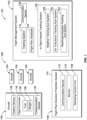
- FIG. 1 is a schematic block diagram of a flight plan diversion prediction system 100 in communication with a flight management system 102 and one or more aircraft 104 within an airspace 106, according to an embodiment of the present disclosure.
- An aircraft management system 101 includes the flight plan diversion prediction system 100, the flight management system 102, and the aircraft 104.
- the flight plan diversion prediction system 100 includes a rerouting control unit 108 in communication with a monitor 110 and a communication device 112, such as through one or more wired or wireless connections.
- the monitor 110 may be a display screen, such as a touchscreen display, a computer display screen, a television, and/or the like.
- the communication device 112 may be or include one or more antennas, radio units, transceivers, receivers, transmitters, and/or the like. The communication device 112 allows the flight plan diversion prediction system 100 to communicate with the flight management system 102 and one or more of aircraft 104 within the airspace 106.
- the flight plan diversion prediction system 100 may be contained within a housing 114, such as a computer workstation, a handheld device (such as a smart phone or pad), and/or the like. As shown, the flight plan diversion prediction system 100 may be separate and distinct from the aircraft 104 and the flight management system 102. For example, the flight plan diversion prediction system 100 may be located at a monitoring station (such as at an air traffic control tower, flight operations center, and/or the like) that is remotely located from the aircraft 104.
- a monitoring station such as at an air traffic control tower, flight operations center, and/or the like
- the flight plan diversion prediction system 100 may be onboard an aircraft 104.
- one or more of the aircraft 104 within the airspace 106 may include a flight plan diversion prediction system 100.
- a flight computer 116 of an aircraft 104 may include the flight plan diversion prediction system 100.
- the flight plan diversion prediction system 100 may be configured to be conveyed into and out of the aircraft 104.
- the flight plan diversion prediction system 100 may be a separate and distinct computing device (such as a handheld device) of flight personnel, such as a pilot.
- the flight management system 102 may be remotely located from the flight plan diversion prediction system 100, or may be collocated with the flight plan diversion prediction system 100.
- both the flight management system 102 and the flight plan diversion prediction system 100 may be located at a flight operations center, an air traffic control tower, or the like.
- the flight management system 102 may include the flight plan diversion prediction system 100.
- the flight plan diversion prediction system 100 may be onboard an aircraft 104 or at another location that is remote from the flight management system 102.
- the flight management system 102 may include a tracking system 118, a flight plan database 120, an in-flight hazard tracking system 122, and a communication device 124, such as one or more antennas, radio units, transceivers, receivers, transmitters, and/or the like that allow for communication with the flight plan diversion prediction system 100 and the aircraft 104.
- the flight management system 102 may include the tracking system 118, the flight plan database 120, the in-flight hazard tracking system 122, and the communication device 124 at a common location, such as at an flight operations center or an air traffic control tower.
- at least one of the tracking system 118, the flight plan database 120, and the in-flight hazard tracking system 122 may be remotely located from one another.
- the tracking system 118 is configured to track positions of the aircraft 104 within the airspace 106.
- the aircraft 104 may include a position sensor 126 that outputs a position signal that is received and tracked by the tracking system 118.
- the position signal is an automatic dependent surveillance-broadcast (ADS-B) signal and the tracking system 118 is an ADS-B tracking system.
- the position signal includes one or more position parameters, such as speed, altitude, heading, and the like.
- the aircraft 104 may be tracked through radar (for example, the tracking system 118 may be or include a radar system).
- the flight plan database 120 stores flight plans (which may include future planned routes and/or current or previous actual flight paths flown) for the aircraft 104.
- the flight plan database 120 may store the current flight plan for the aircraft 104.
- the flight plan database 120 may also store one or more reroute options (to a particular destination) for the aircraft 104, whether or not the reroute options are chosen by a pilot.
- the flight plans may include original flight plans for the aircraft 104 that include flight paths between departure locations and arrival or destination locations.
- each aircraft 104 may include a flight plan database 120, which may store an original flight plan for the aircraft 104 from a departure location to an arrival location.
- the flight plan database 120 may be separate and distinct from the flight management system 102.
- the in-flight hazard tracking system 122 is configured to track in real time one or more types of in-flight hazards within the airspace 106.
- the in-flight hazard tracking system 122 includes one or more of a weather tracking sub-system 128, an air turbulence tracking sub-system 130, and a restricted airspace tracking sub-system 132.
- the in-flight hazard tracking system 122 may be part of the flight management system 102, as shown, or may be remotely located from and in communication with the flight management system 102, such as through one or more communication devices.
- the weather tracking sub-system 128 may be any type of system that tracks current weather.
- the weather tracking sub-system 128 may include a Doppler radar, a weather forecasting service, and/or the like.
- the weather tracking sub-system 128 is configured to monitor and track weather within the airspace 106 in real time, and may also provide weather predictions for the future.
- the air turbulence tracking sub-system 130 is configured to track and/or predict locations of air turbulence within the airspace 106.
- the air turbulence tracking sub-system 130 may include a reporting service or system that determines locations of air turbulence within the airspace 106, such as through reports from pilots.
- the in-flight hazard tracking system 122 may not include the air turbulence tracking sub-system 130.
- the restricted airspace tracking sub-system 132 is configured to track and/or predict locations of restricted airspace within the airspace 106.
- the restricted airspace tracking sub-system 132 may include a reporting service or system that determines locations of restricted airspace within the airspace 106, such as through airport or governmental notices, reports, and/or the like.
- the in-flight hazard tracking system 122 may not include the restricted airspace tracking sub-system 132.
- the weather tracking sub-system 128, the air turbulence tracking sub-system 130, and/or the restricted airspace tracking sub-system 132 are separate, distinct, and remote from the flight management system 102.
- the weather tracking sub-system 128, the air turbulence tracking sub-system 130, and/or the restricted airspace tracking sub-system 132 may be separately in communication with the flight plan diversion prediction system 100.
- the aircraft 104 includes the flight computer 116 and the position sensor 126, as noted above.
- the aircraft 104 also includes a communication device 134, such as one or more antennas, radio units, transceivers, receivers, transmitters, and/or the like, that allow the aircraft 104 to communicate with the flight plan diversion prediction system 100 and the flight management system 102.
- the flight computer 116 assesses a current amount of fuel 136 and weight 138 of the aircraft 104.
- the flight computer 116 determines the amount of fuel 136 burned by comparing the total amount of fuel 136 before takeoff to the current level of fuel 136. Further, the flight computer 116 determines a remaining amount of fuel 136 (that is, the current amount of fuel 136 onboard the aircraft 104). Similarly, the flight computer 116 determines the current weight 138 of the aircraft 104, and determines the difference between the current weight 138 and the weight 138 before takeoff.
- the aircraft 104 may divert from an original flight plan to a diverted flight plan based on an in-flight hazard as determined by the in-flight hazard tracking system 122.
- the weather tracking sub-system 128 may detect hazardous weather within the airspace 106.
- the aircraft 104 may receive the weather report alert from the weather tracking sub-system 128, and the pilot may decide to divert around the weather.
- the aircraft 104 may divert from the original flight plan to a diverted plan due to air turbulence within the airspace 106, as determined by the air turbulence tracking sub-system 130, or a restricted airspace within the airspace 106, as determined by the restricted airspace tracking sub-system 132.
- Hazardous weather (as detected and/or determined by the weather tracking sub-system 128), air turbulence (as detected and/or determined by the air turbulence tracking sub-system 130), and a restricted airspace (as detected and/or determined by the restricted airspace tracking sub-system 132) are examples of in-flight hazards within the airspace 106 that a pilot may decide to divert around (that is, deviate from a current flight plan to a diverted flight plan to avoid such in-flight hazards).
- the rerouting control unit 108 analyzes the current position of the aircraft 104. For example, the rerouting control unit 108 detects a current heading, position, and airspeed of the aircraft 104, such as determined by the tracking system 118. The rerouting control unit 108 may also analyze a current location of the in-flight hazard, such as hazardous weather as detected by the weather tracking sub-system 128. The rerouting control unit 108 analyzes the position of the aircraft 104 within the airspace 106, and the in-flight hazard, and determines one or more reroute options for the aircraft 104. The reroute options provide one or more diverted flight plan options that connect to a landing location, such as the arrival or destination location within the current or original flight plan.
- the reroute options include a predicted amount of fuel and weight of the aircraft at the landing location.
- the rerouting control unit 108 may communicate with the flight computer 116 to determine a current fuel 136 and weight 138 of the aircraft 104 and determine the predicted amount of fuel 136 and weight 138 at the landing location based on the determined reroute path and the current fuel consumption rate (that is, fuel burn) of the aircraft 104.
- the reroute option(s), including the predicted amount of fuel 136 and the predicted aircraft weight 138 at the landing location, are shown on the monitor 110.
- control unit central processing unit
- unit unit
- CPU central processing unit
- ASIC application specific integrated circuits
- rerouting control unit 108 may be or include one or more processors that are configured to control operation thereof, as described herein.
- the rerouting control unit 108 is configured to execute a set of instructions that are stored in one or more data storage units or elements (such as one or more memories), in order to process data.
- the rerouting control unit 108 may include or be coupled to one or more memories.
- the data storage units may also store data or other information as desired or needed.
- the data storage units may be in the form of an information source or a physical memory element within a processing machine.
- the set of instructions may include various commands that instruct the rerouting control unit 108 as a processing machine to perform specific operations such as the methods and processes of the various embodiments of the subject matter described herein.
- the set of instructions may be in the form of a software program.
- the software may be in various forms such as system software or application software. Further, the software may be in the form of a collection of separate programs, a program subset within a larger program or a portion of a program.
- the software may also include modular programming in the form of object-oriented programming.
- the processing of input data by the processing machine may be in response to user commands, or in response to results of previous processing, or in response to a request made by another processing machine.
- the diagrams of embodiments herein may illustrate one or more control or processing units, such as the rerouting control unit 108.
- the processing or control units may represent circuits, circuitry, or portions thereof that may be implemented as hardware with associated instructions (e.g., software stored on a tangible and non-transitory computer readable storage medium, such as a computer hard drive, ROM, RAM, or the like) that perform the operations described herein.
- the hardware may include state machine circuitry hardwired to perform the functions described herein.
- the hardware may include electronic circuits that include and/or are connected to one or more logic-based devices, such as microprocessors, processors, controllers, or the like.
- the rerouting control unit 108 may represent processing circuitry such as one or more of a field programmable gate array (FPGA), application specific integrated circuit (ASIC), microprocessor(s), and/or the like.
- the circuits in various embodiments may be configured to execute one or more algorithms to perform functions described herein.
- the one or more algorithms may include aspects of embodiments disclosed herein, whether or not expressly identified in a flowchart or a method.
- the terms "software” and “firmware” are interchangeable, and include any computer program stored in a data storage unit (for example, one or more memories) for execution by a computer, including RAM memory, ROM memory, EPROM memory, EEPROM memory, and non-volatile RAM (NVRAM) memory.
- a data storage unit for example, one or more memories
- NVRAM non-volatile RAM
- the above data storage unit types are exemplary only, and are thus not limiting as to the types of memory usable for storage of a computer program.
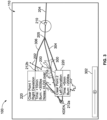
- FIG 2 is a diagrammatic representation of a front view of the monitor 110 of the flight plan diversion prediction system 100, according to an embodiment of the present disclosure.
- the weather tracking sub-system 128 detects a weather cell 200 having a vector 202 (including airspeed and direction).
- the flight plan diversion prediction system 100 receives data regarding the weather cell 200 from the weather tracking sub-system 128 and shows the weather cell 200 on the monitor 110.
- the monitor 110 also shows a portion of an original flight plan 204 (which the flight plan diversion prediction system 100 may receive from the flight plan database 120) to a destination location 206.
- the aircraft 104 has diverted into a diverted flight plan 208.
- the current position of the aircraft 104 (as detected by the tracking system 118) is shown on the monitor 110 by a current position indicator 210.
- a clearpoint 212 is also shown on the monitor 110.
- the clearpoint 212 is a location on the diverted flight plan 208 at which the aircraft 104 will be clear of the weather cell 200 (or other such in-flight hazard) based on the current course, airspeed and heading at a particular time.
- the rerouting control unit 108 determines the location of the clearpoint 212. For example, the rerouting control unit 108 analyzes the weather cell 200 and the vector 202 to determine a location of the weather cell 200 at a particular time. The rerouting control unit 108 compares the predicted location of the weather cell 200 and the vector 202 with the current position (as shown by the current position indicator 210) of the aircraft 104 to determine the clearpoint 212. For example, based on the diverted flight plan 208, the current position of the aircraft along the diverted flight plan 208, the movement of the weather cell 200, and the predicted motion of the weather cell 200 based on the vector 202, the rerouting control unit 108 determines the clearpoint 212.
- the rerouting control unit 108 assesses the current position, heading, and airspeed of the aircraft 104 on the diverted flight plan 208 (such as detected by the tracking system 118). The rerouting control unit 108 then compares the current position, heading, and airspeed (and optionally previous position, heading, and airspeed for a predetermined time) of the aircraft 104 with the location of the weather cell 200 and predicted location of the weather cell 200 at a future, later time based on the motion of the weather cell 200 as determined via the vector 202, and determines the location at which the aircraft 104 will be clear of the weather cell 200 at a future, later time (that is, the clearpoint 212).
- the clearpoint 212 may be dynamically and automatically determined by the rerouting control unit 108, such as based on the current location, heading, and airspeed of the aircraft 104 in relation to the current location and vector 202 of the weather cell 200 (the analysis of which allows the rerouting control unit 108 to predict the future positions of the aircraft 104 and the weather cell 200).
- the rerouting control unit 108 determines one or more reroute options 214, 216, and 218 for the aircraft 104.
- the reroute options 214, 216, and 218 may link or join back to the original flight plan 204.
- At least one of the reroute options 214, 216, or 218 may not link or join back to the original flight plan 204.
- the rerouting control unit 108 predicts or otherwise determines one or more flight path aspects (such as predicting remaining fuel, weight, or the like) for the aircraft 104 at the destination location 206 (if the aircraft 104 were to fly according to the particular reroute option 214, 216, and 218).
- the rerouting control unit 108 determines and predicts the flight path aspect(s) based on the current flight path aspect(s) of the aircraft 104 at the current location (such as remaining fuel, current airspeed, and current consumption level of fuel) and the length of the reroute options 214, 216, and 218.
- the rerouting control unit 108 For each reroute option 214, 216, and 218, the rerouting control unit 108 provides reroute information indicator 220, such as a box or area 229 (which may be expandable, such as through a swipe, slide, tap or the like of a finger, stylus, or the like). An individual may expand the reroute information indicator 220, such as by tapping with a finger (when the monitor is a touchscreen interface, for example), pointing and clicking with an engagement device (such as a stylus or mouse), and/or the like.
- reroute information indicator 220 such as a box or area 229 (which may be expandable, such as through a swipe, slide, tap or the like of a finger, stylus, or the like).
- An individual may expand the reroute information indicator 220, such as by tapping with a finger (when the monitor is a touchscreen interface, for example), pointing and clicking with an engagement device (such as a stylus or mouse), and/or the like.
- Each reroute information indicator 220 may list one or more predicted flight path aspects, such as a predicted landing weight 222, predicted fuel on board (FOB) 224, predicted fuel remaining 226 at the destination, and/or a predicted estimated time of arrival (ETA) 228 at the destination location 206 if the pilot chooses to fly according to a particular reroute option 214, 216, and 218.
- the reroute information indicator 220 may also include the FOB as of the current time. The pilot may then compare the predicted flight path aspects for each of the reroute options 214, 216, and 218 to make an informed decision as to an efficient and/or safe reroute option 214, 216, or 218 to choose.
- the rerouting control unit 108 determines and shows three reroute options on the monitor 110.
- the rerouting control unit 108 may determine and show more or less than three reroute options.
- the rerouting control unit 108 may determine 4 or more reroute options to the destination location 206 from the clearpoint 212.
- the rerouting control unit 108 indicates the clearpoint 212 on the monitor 110 and provides one or more reroute options 214, 216, and/or 218, each of which includes reroute information indicator 220 listing one or more flight path aspects, thereby allowing a pilot of the aircraft 104 to know a predicted amount of fuel and weight at the destination location 206. Further, the rerouting control unit 108 provides a point in future time and space (that is, the clearpoint 212) from which a new route (such as the reroute options 214, 216, and 218) are determined. Accordingly, the flight plan diversion prediction system 100 provides a pilot with the ability to perform an informed and tactical flight plan diversion and reroute from the original flight plan 204. The flight plan diversion prediction system 100 allows the pilot to determine a tactical reroute without losing insight into how much fuel will be onboard the aircraft 104 upon landing at the destination location 206.
- the reroute options 214, 216, 218 may be received by the flight management system 102, and stored in the flight plan database 120.
- a reroute option 214, 216, or 218, that is chosen by a pilot may be stored in the flight plan database 120 as an active reroute option.
- a reroute option 214, 216, or 218 that is not chosen by a pilot may be stored in the flight plan database as an inactive reroute option, or, alternatively discarded.
- the reroute options 214, 216, 218 include the clearpoint 212.
- the reroute options 214, 216, 218 each start from the clearpoint 212.
- Figure 3 is a diagrammatic representation of a front view of the monitor 110 of the flight plan diversion prediction system 100, according to an embodiment of the present disclosure.
- the current location of an aircraft 104 is shown by current position indicator 210.
- the current position indicator 210 is along an original flight plan 204.
- a future point along the original flight plan 204 is shown by a future position indicator 300.
- the future position indicator 300 is correlated with a predicted position at a future time along the original flight plan 204 if the aircraft 104 continues to fly according to the original flight plan 204.
- the rerouting control unit 108 shows the predicted position of the weather cell 200 and vector 202 (based on past motion and current position of the weather cell 200) on the monitor 110, and determines a predicted position of the aircraft 104 as indicated by the future position indicator 300 on the original flight plan 204.
- a time selector 302 (such as a slide bar on a touchscreen interface of the monitor 110) may be operated by an individual to illustrate relative positions of the weather cell 200 and the future position indicator 300. For example, a pilot may see the current position of the weather cell 200, and may move the time selector 302 to a position thirty minutes into the future, at which the rerouting control unit 108 shows the predicted position of the weather cell 200 along with the future position indicator 300 at the selected future time. If the rerouting control unit 108 determines and shows that the aircraft 104 will avoid the predicted position of the weather cell 200 at the selected future time, the pilot may opt to remain on the original fight plan 204.
- the pilot may choose a diverted flight path. For example, the pilot may choose from a first heading change that provides a first reroute option 304 (showing a first diverted flight path) starting from a diversion point 205 from the flight plan 204, and a second heading change that differs from the first heading change that provides a second reroute option 306 (showing a second diverted flight path) starting from the diversion point 205. Clearpoints 212a and 212b may be determined for each of the reroute options 304 and 306, respectively, as explained above.
- each of the first reroute option 304 and the second reroute option 306 includes a separate and distinct clearpoint 212a and 212b, respectively.
- the rerouting control unit 108 may determine and show on the monitor 110 reroute information indicator 220 that may list one or more predicted flight path aspects. Based on the predicted flight path aspects, as shown in the reroute information indicator 220, the pilot may make an informed decision as to an efficient and/or safe reroute option 304 or 306 to pick.
- the first reroute option 304 may add five minutes of flight time and burn two hundred extra pounds of fuel in relation to the original fight plan 204
- the second reroute option 306 may add ten minutes of flight time and burn three hundred extra pounds of fuel in relation to the original flight plan 204.
- the pilot may opt for the first reroute option 304 (assuming the first reroute option 304 and the second reroute option 306 are substantially equally as safe), as it takes less total flight time and burns less fuel as compared to the second reroute option 306.
- the rerouting control unit 108 may monitor other aircraft 104 that are closer (and/or already landed) to the destination location in addition to monitoring the aircraft 104 indicated at the current position indicator 210.
- the rerouting control unit 108 may determine the rerouted flight paths chosen by the previous aircraft 104. For example, pilots of one or more previous aircraft 104 may have chosen a rerouted flight path to the North of the weather cell 200, while other aircraft 104 later in time may have chosen a rerouted flight path to the South of the weather cell 200.
- the rerouting control unit 108 may analyze the previously rerouted flight paths to determine the reroute options 304 and 306, including the diverted flight paths.
- the rerouting control unit 108 may determine the reroute options 304 and 306 based on weighted averages (such as of actual fuel and weight at the destination location, fuel burn, and/or the like) of the previous rerouted flight paths, for example.
- the rerouting control unit 108 of the flight plan diversion prediction system 100 shows tactically on the monitor 110 an efficient (or relatively efficient as compared to others) and/or safe (or relatively safe as compared to others) diverted flight path via a comparison of the reroute options 304 and 306.
- the rerouting control unit 108 may analyze the flight path data of previous aircraft in front of the aircraft 104 denoted by the current position indicator 210 either in real time or via historical data to predict a time and fuel burn of the aircraft 104 for the reroute options 304 and 306.
- the rerouting control unit 108 is able to determine additional time and fuel approximations, and also if additional delays are present such as due to in-flight holding (for example, holding patterns).
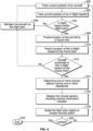
- FIG. 4 illustrates a flow chart of an aircraft management method, according to an embodiment of the present disclosure.
- a current position of an aircraft 104 is tracked, such as via the tracking system 118.
- a current position of an in-flight hazard (such as a weather cell, location of air turbulence, or restricted airspace) is tracked, such as via the in-flight hazard tracking system 122.
- the rerouting control unit 108 determines whether the in-flight hazard is (and/or will be) within a current flight plan of the aircraft 104.
- an individual such as a pilot, may determine whether the in-flight hazard is within the current flight plan. If not, the method proceeds from 404 to 406, at which the aircraft is maintained on the current flight plan, and then the method returns to 400.
- the method proceeds from 404 to 408, at which the rerouting control unit 108 predicts the location of the aircraft 104 at a future time (that is, a time later than the current time).
- the rerouting control unit 108 may predict the location of the aircraft 104 at the future time by analyzing the past and current position, heading, direction, airspeed and/or the like of the aircraft, and making the prediction of the location of the aircraft based thereon.
- the rerouting control unit 108 predicts a location of the in-flight hazard at the future time. For example, the rerouting control unit 108 may predict the location of the in-flight hazard at the future time by analyzing the past and current position and vector of the in-flight hazard, and making the prediction of the location of the in-flight hazard based thereon.
- the rerouting control unit 108 determines whether the aircraft 104 will be proximate to (for example, at and/or within a predetermined range) the in-flight hazard at the future time, based on the predicted location of the aircraft 104 and the predicted location of the in-flight hazard at the future time. If the aircraft 104 will not be proximate to the in-flight hazard at the future time, the method proceeds from 412 to 406, and then back to 400.
- the method proceeds from 412 to 414, at which the rerouting control unit 108 determines one or more reroute options having one or more clearpoints.
- the rerouting control unit 108 displays the reroute options including reroute information indicator on the monitor 110.
- the flight plan is adapted (for example, changed) based on a reroute option that is chosen by a pilot.
- the rerouting control unit 108 determines if the aircraft 104 has landed at a location. If so, the method ends at 422. If the aircraft 104 has not yet landed, the method returns to 400.
- the flight plan diversion prediction system 100 includes the rerouting control unit 108 that generates one or more reroute options for an aircraft 104 based on an analysis of a current position of the aircraft 104, a predicted future position (that is, a position at a future time) of the aircraft 104, a current position of an in-flight hazard, and a predicted future position (that is, a position at the future time) of an in-flight hazard.
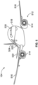
- FIG. 5 is a diagrammatic representation of a front perspective view of an aircraft 104.
- the aircraft 104 includes a propulsion system 512 that may include two turbofan engines 514, for example.
- the propulsion system 512 may include more engines 514 than shown.
- the engines 514 are carried by wings 516 of the aircraft 104.
- the engines 514 may be carried by a fuselage 518 and/or an empennage 520.
- the empennage 520 may also support horizontal stabilizers 522 and a vertical stabilizer 524.
- the fuselage 518 of the aircraft 104 defines an internal cabin, which may include a cockpit 530 that includes the flight computer 116 (shown in Figure 1 ), for example. Further, the flight plan diversion prediction system 100 (shown in Figure 1 ) may be within the cockpit 530.
- the aircraft 104 may be sized, shaped, and configured other than shown in Figure 5 .
- the aircraft 104 may be a non-fixed wing aircraft, such as a helicopter.
- the aircraft 104 may be an unmanned aerial vehicle (UAV).
- UAV unmanned aerial vehicle
- embodiments of the present disclosure provide systems and methods that allow large amounts of data to be quickly and efficiently analyzed by a computing device. For example, numerous aircraft 104 may be scheduled to fly within the airspace 106. As such, large amounts of data are being tracked and analyzed. The vast amounts of data are efficiently organized and/or analyzed by the rerouting control unit 108, as described herein. The rerouting control unit 108 analyzes the data in a relatively short time in order to quickly and efficiently output and/or display reroute information for the aircraft 104.
- the rerouting control unit 108 analyzes current locations of the aircraft 104 and in-flight hazards in real or near real time to determine reroute options for one or more of the aircraft 104 based on predicted positions of the aircraft 104 and the in-flight hazards at future times.
- a human being would be incapable of efficiently analyzing such vast amounts of data in such a short time.
- embodiments of the present disclosure provide increased and efficient functionality with respect to prior computing systems, and vastly superior performance in relation to a human being analyzing the vast amounts of data.
- embodiments of the present disclosure provide systems and methods that analyze thousands, if not millions, of calculations and computations that a human being is incapable of efficiently, effectively and accurately managing.
- embodiments of the present disclosure provide systems and methods for accurately predicting various flight path aspects of an aircraft that has diverted from an original flight plan. Further, the systems and methods allow pilots to predict how much fuel an aircraft might have at a destination before and after diverting from a flight plan. Moreover, the systems and methods provide and display one or more flight path diversion options. While various spatial and directional terms, such as top, bottom, lower, mid, lateral, horizontal, vertical, front and the like may be used to describe embodiments of the present disclosure, it is understood that such terms are merely used with respect to the orientations shown in the drawings. The orientations may be inverted, rotated, or otherwise changed, such that an upper portion is a lower portion, and vice versa, horizontal becomes vertical, and the like.
- a structure, limitation, or element that is "configured to” perform a task or operation is particularly structurally formed, constructed, or adapted in a manner corresponding to the task or operation.
- an object that is merely capable of being modified to perform the task or operation is not “configured to” perform the task or operation as used herein.
Landscapes
- Engineering & Computer Science (AREA)
- Aviation & Aerospace Engineering (AREA)
- Physics & Mathematics (AREA)
- General Physics & Mathematics (AREA)
- Traffic Control Systems (AREA)
- Navigation (AREA)
- Radar, Positioning & Navigation (AREA)
- Remote Sensing (AREA)
Claims (15)
- Luftfahrzeug-Managementsystem (101), aufweisend:ein System zur Vorhersage von Flugplanabweichungen (114) mit einer Umleitungssteuereinheit (108),wobei die Umleitungssteuereinheit (108) dazu ausgebildet ist, eine Mehrzahl von Umleitungsoptionen (214, 216, 218) für ein Luftfahrzeug (104) zu erzeugen,wobei die Umleitungssteuereinheit (108) dazu ausgebildet ist, einen Freigabepunkt (212) für die Mehrzahl von Umleitungsoptionen (214, 216, 218) basierend auf der aktuellen Position, dem aktuellen Kurs und der aktuellen Fluggeschwindigkeit des Luftfahrzeugs (104) in Bezug auf die aktuelle Position, Fluggeschwindigkeit und Richtung der Gefahr im Flug zu bestimmen, wodurch die Umleitungssteuereinheit (108) in der Lage ist, die zukünftige Position des Luftfahrzeugs sowie die zukünftige Position der Gefahr im Flug vorherzusagen, wobei der Freigabepunkt (212) eine Position ist, an der sich das Luftfahrzeug (104) außerhalb der Gefahr im Flug befindet, und wobei die Umleitungssteuereinheit (108) dazu ausgebildet ist, den Freigabepunkt (212) durch Vergleich der vorhergesagten zukünftigen Position des Luftfahrzeugs (104) mit der vorhergesagten zukünftigen Position der Gefahr im Flug zu bestimmen,wobei die Mehrzahl von Umleitungsoptionen (214, 216, 218) auf einer Analyse der aktuellen Position des Luftfahrzeugs (104), der vorhergesagten zukünftigen Position des Luftfahrzeugs (104), der aktuellen Position einer Gefahr im Flug und der vorhergesagten zukünftigen Position der Gefahr im Flug basiert, wobei jede der Mehrzahl von Umleitungsoptionen (214, 216, 218) am Freigabepunkt (212) beginnt,wobei das System zur Vorhersage von Flugplanabweichungen (114) ferner eine Anzeige (110) aufweist, die mit der Umleitungssteuereinheit (108) kommuniziert, undwobei die Umleitungssteuereinheit (108) dazu ausgebildet ist, die Mehrzahl von Umleitungsoptionen (214, 216, 218) auf der Anzeige (110) darzustellen.
- Luftfahrzeug-Managementsystem (101) nach Anspruch 1, wobei die Umleitungssteuereinheit (108) dazu ausgebildet ist, einen Umleitungsinformationsindikator (220) für mindestens eine der Mehrzahl von Umleitungsoptionen (214, 216, 218) auf der Anzeige (110) darzustellen.
- Luftfahrzeug-Managementsystem (101) nach Anspruch 2, wobei der Umleitungsinformationsindikator (220) eines oder mehrere der folgenden Elemente aufweist: vorhergesagtes Landegewicht (222), vorhergesagter Kraftstoff an Bord (FOB) (136, 224), vorhergesagter verbleibender Kraftstoff bei Ankunft (226) und vorhergesagte geschätzte Ankunftszeit (ETA) (228).
- Luftfahrzeug-Managementsystem (101) nach einem der Ansprüche 1 bis 3, wobei das System zur Vorhersage von Flugplanabweichungen (114) sich an Bord des Luftfahrzeugs (104) befindet.
- Luftfahrzeug-Managementsystem (101) nach einem der Ansprüche 1 bis 4, ferner aufweisend ein Nachführungssystem (118), das dazu ausgebildet ist, die aktuelle Position des Luftfahrzeugs (104) zu verfolgen.
- Luftfahrzeug-Managementsystem (101) nach einem der Ansprüche 1 bis 5, ferner aufweisend eine Flugplandatenbank (120), die einen aktuellen Flugplan (204, 208) des Luftfahrzeugs (104) speichert.
- Luftfahrzeug-Managementsystem (101) nach einem der Ansprüche 1 bis 6, ferner aufweisend ein System zur Nachverfolgung von Gefahren im Flug (122), das dazu ausgebildet ist, die aktuelle Position der Gefahr im Flug zu verfolgen.
- Luftfahrzeug-Managementsystem (101) nach einem der Ansprüche 1 bis 7, wobei die eine oder mehrere Umleitungsoptionen (214, 216, 218) einen oder mehrere Flugaspekte für das Luftfahrzeug (104) an einem Zielort (206) aufweisen.
- Luftfahrzeug-Managementsystem (101) nach einem der Ansprüche 1 bis 8, wobei die Umleitungssteuereinheit (108) ferner dazu ausgebildet ist, die Mehrzahl von Umleitungsoptionen (214, 216, 218) basierend auf einer Analyse von Flugplänen (204, 208) vorangegangener Luftfahrzeuge (104) zu erzeugen.
- Luftfahrzeug-Managementsystem (101) nach einem der Ansprüche 1 bis 9, wobei das System zur Nachverfolgung von Gefahren im Flug (122) ein Subsystem zur Verfolgung von Luftturbulenzen aufweist, das dazu ausgebildet ist, Luftturbulenzen zu verfolgen, und wobei die Gefahr im Flug die Luftturbulenzen einschließt.
- Verfahren zum Management eines Luftfahrzeugs (104), aufweisend:Bestimmen einer aktuellen Position eines Luftfahrzeugs (104) innerhalb eines Luftraums (106);Bestimmen einer aktuellen Position einer Gefahr im Flug innerhalb des Luftraums (106);Vorhersagen einer vorhergesagten zukünftigen Position des Luftfahrzeugs (104) durch eine Umleitungssteuereinheit (108) eines Systems zur Vorhersage von Flugplanabweichungen (114);Vorhersagen einer vorhergesagten zukünftigen Position der Gefahr im Flug durch die Umleitungssteuereinheit (108);Bestimmen eines Freigabepunkts (212) durch die Umleitungssteuereinheit (108) für die Mehrzahl von Umleitungsoptionen (214, 216, 218), wobei der Freigabepunkt (212) eine Position ist, an der sich das Luftfahrzeug (104) außerhalb der Gefahr im Flug befindet, basierend auf der aktuellen Position, dem aktuellen Kurs und der aktuellen Fluggeschwindigkeit des Luftfahrzeugs (104) in Bezug auf die aktuelle Position, Fluggeschwindigkeit und Richtung der Gefahr im Flug, wodurch die Umleitungssteuereinheit (108) die zukünftige Position des Luftfahrzeugs und die zukünftige Position der Gefahr im Flug vorhersagen kann, und wobei das Bestimmen des Freigabepunkts (212) den Vergleich der vorhergesagten zukünftigen Position des Luftfahrzeugs (104) mit der vorhergesagten zukünftigen Position der Gefahr im Flug aufweist;Erzeugen einer Mehrzahl von Umleitungsoptionen (214, 216, 218) durch die Umleitungssteuereinheit (108) für das Luftfahrzeug (104), basierend auf einer Analyse der aktuellen Position des Luftfahrzeugs (104), der vorhergesagten zukünftigen Position des Luftfahrzeugs (104), der aktuellen Position einer Gefahr im Flug und der vorhergesagten zukünftigen Position der Gefahr im Flug, wobei jede der Mehrzahl von Umleitungsoptionen (214, 216, 218) am Freigabepunkt (212) beginnt; undDarstellen der Mehrzahl von Umleitungsoptionen (214, 216, 218) auf einer Anzeige (110), die mit der Umleitungssteuereinheit (108) kommuniziert.
- Verfahren zum Management eines Luftfahrzeugs (104) nach Anspruch 11, wobei das Darstellen das Darstellen eines Umleitungsinformationsindikators (220) für mindestens eine der Mehrzahl von Umleitungsoptionen (214, 216, 218) auf der Anzeige (110) aufweist.
- Verfahren zum Management eines Luftfahrzeugs (104) nach Anspruch 11 oder 12, ferner aufweisend das Speichern von mindestens einem der folgenden Elemente in einer Flugplandatenbank (120): einem aktuellen Flugplan (204, 208) des Luftfahrzeugs (104) oder der Mehrzahl von Umleitungsoptionen (214, 216, 218).
- Verfahren zum Management eines Luftfahrzeugs (104) nach einem der Ansprüche 11 bis 13, wobei das Erzeugen das Analysieren von Flugplänen (204, 208) vorheriger Luftfahrzeuge (104) aufweist.
- Verfahren zum Management eines Luftfahrzeugs (104) nach einem der Ansprüche 11 bis 14, ferner aufweisend das Verfolgen von Luftturbulenzen durch ein Sub-system zur Verfolgung von Luftturbulenzen, wobei die Gefahr im Flug die Luftturbulenzen einschließt.
Applications Claiming Priority (1)
| Application Number | Priority Date | Filing Date | Title |
|---|---|---|---|
| US16/145,705 US10909858B2 (en) | 2018-09-28 | 2018-09-28 | Aircraft flight management systems and methods |
Publications (2)
| Publication Number | Publication Date |
|---|---|
| EP3629313A1 EP3629313A1 (de) | 2020-04-01 |
| EP3629313B1 true EP3629313B1 (de) | 2025-05-14 |
Family
ID=67659377
Family Applications (1)
| Application Number | Title | Priority Date | Filing Date |
|---|---|---|---|
| EP19192420.8A Active EP3629313B1 (de) | 2018-09-28 | 2019-08-20 | Flugzeugflugverwaltungssysteme und -verfahren |
Country Status (4)
| Country | Link |
|---|---|
| US (1) | US10909858B2 (de) |
| EP (1) | EP3629313B1 (de) |
| JP (1) | JP7509521B2 (de) |
| CN (1) | CN110969899B (de) |
Families Citing this family (13)
| Publication number | Priority date | Publication date | Assignee | Title |
|---|---|---|---|---|
| US10847040B2 (en) * | 2018-08-21 | 2020-11-24 | The Boeing Company | Restricted airspace monitoring systems and methods |
| JP7671631B2 (ja) | 2020-08-21 | 2025-05-02 | ザ・ボーイング・カンパニー | 3次元の経路に沿った気象現象の可視化 |
| EP3979034B1 (de) * | 2020-10-05 | 2025-01-01 | Advanced Laboratory on Embedded Systems S.r.l. | Sicherheitsmonitor |
| JP7044910B1 (ja) * | 2021-01-21 | 2022-03-30 | Kddi株式会社 | 飛行管理装置及び飛行管理方法 |
| US11928972B2 (en) * | 2021-07-08 | 2024-03-12 | Ge Aviation Systems Llc | Systems and methods for a dynamic re-route interface |
| CN113593306B (zh) * | 2021-08-13 | 2022-05-24 | 中国民航大学 | 基于安全性的散点状雷暴危险天气下改航方法 |
| US11393342B1 (en) * | 2021-08-19 | 2022-07-19 | Beta Air, Llc | Systems and methods for digital communication of flight plan |
| US20230386346A1 (en) * | 2022-05-26 | 2023-11-30 | The Boeing Company | Aircraft flight management systems and methods |
| CN115440091B (zh) * | 2022-11-03 | 2023-07-04 | 成都沃飞天驭科技有限公司 | 航路切换视景显示方法、装置、飞行器及存储介质 |
| EP4710179A2 (de) * | 2023-06-13 | 2026-03-18 | Mammoth Freighters LLC | Verfahren, system und computerlesbares medium zur kalibrierung von leistungsparametern eines flugzeugs während eines phantomkraftstoffverfahrens |
| CN117334088A (zh) * | 2023-10-25 | 2024-01-02 | 苏武 | 一种基于航迹运行的空中交通管理系统 |
| CN117351785B (zh) * | 2023-10-27 | 2025-10-31 | 亿航智能设备(广州)有限公司 | 航空器的气象数据应用方法、设备及计算机可读存储介质 |
| USD1101811S1 (en) * | 2024-06-24 | 2025-11-11 | The Boeing Company | Display screen or portion thereof with animated graphical user interface |
Citations (3)
| Publication number | Priority date | Publication date | Assignee | Title |
|---|---|---|---|---|
| US8234068B1 (en) * | 2009-01-15 | 2012-07-31 | Rockwell Collins, Inc. | System, module, and method of constructing a flight path used by an avionics system |
| US8843303B1 (en) * | 2012-12-17 | 2014-09-23 | Rockwell Collins, Inc. | Risk-aware contingency flight re-planner system and related method |
| EP2790168A2 (de) * | 2013-04-11 | 2014-10-15 | Airbus Operations (S.A.S) | Vorrichtungen, Systeme, computerlesbare Medien und zugehörige Verfahren zur Flugverwaltung |
Family Cites Families (12)
| Publication number | Priority date | Publication date | Assignee | Title |
|---|---|---|---|---|
| JP2655095B2 (ja) * | 1994-08-25 | 1997-09-17 | 日本電気株式会社 | 航空機に搭載するフライトプラン評価生成装置 |
| US6522958B1 (en) | 2000-10-06 | 2003-02-18 | Honeywell International Inc. | Logic method and apparatus for textually displaying an original flight plan and a modified flight plan simultaneously |
| US6542796B1 (en) | 2000-11-18 | 2003-04-01 | Honeywell International Inc. | Methods and apparatus for integrating, organizing, and accessing flight planning and other data on multifunction cockpit displays |
| US9014880B2 (en) * | 2010-12-21 | 2015-04-21 | General Electric Company | Trajectory based sense and avoid |
| JP5926637B2 (ja) * | 2012-07-10 | 2016-05-25 | 富士重工業株式会社 | 回避経路導出装置、回避経路導出プログラム、および、回避経路導出方法 |
| US9376216B2 (en) * | 2014-05-30 | 2016-06-28 | The Boeing Company | Visual fuel predictor system |
| US9666084B2 (en) | 2014-12-19 | 2017-05-30 | Rockwell Collins, Inc. | Display and control of time evolved conditions relative to a vehicle |
| US9646503B2 (en) * | 2015-02-11 | 2017-05-09 | Honeywell International Inc. | Cockpit display systems and methods for generating navigation displays including landing diversion symbology |
| US9870711B2 (en) * | 2015-06-08 | 2018-01-16 | The Boeing Company | System and method for determining an alternative flight route based on sector geometry |
| US9824593B1 (en) * | 2015-09-21 | 2017-11-21 | Rockwell Collins, Inc. | System and method for holistic flight and route management |
| JP2017220057A (ja) * | 2016-06-08 | 2017-12-14 | 株式会社リコー | 障害物回避装置、障害物回避システムおよびプログラム |
| KR102385014B1 (ko) * | 2016-12-22 | 2022-04-12 | 키티 호크 코포레이션 | 분산형 비행 제어 시스템 |
-
2018
- 2018-09-28 US US16/145,705 patent/US10909858B2/en active Active
-
2019
- 2019-08-20 EP EP19192420.8A patent/EP3629313B1/de active Active
- 2019-08-21 JP JP2019151293A patent/JP7509521B2/ja active Active
- 2019-09-26 CN CN201910920176.1A patent/CN110969899B/zh active Active
Patent Citations (3)
| Publication number | Priority date | Publication date | Assignee | Title |
|---|---|---|---|---|
| US8234068B1 (en) * | 2009-01-15 | 2012-07-31 | Rockwell Collins, Inc. | System, module, and method of constructing a flight path used by an avionics system |
| US8843303B1 (en) * | 2012-12-17 | 2014-09-23 | Rockwell Collins, Inc. | Risk-aware contingency flight re-planner system and related method |
| EP2790168A2 (de) * | 2013-04-11 | 2014-10-15 | Airbus Operations (S.A.S) | Vorrichtungen, Systeme, computerlesbare Medien und zugehörige Verfahren zur Flugverwaltung |
Also Published As
| Publication number | Publication date |
|---|---|
| EP3629313A1 (de) | 2020-04-01 |
| CN110969899B (zh) | 2023-06-27 |
| JP7509521B2 (ja) | 2024-07-02 |
| US20200105146A1 (en) | 2020-04-02 |
| US10909858B2 (en) | 2021-02-02 |
| JP2020057372A (ja) | 2020-04-09 |
| CN110969899A (zh) | 2020-04-07 |
Similar Documents
| Publication | Publication Date | Title |
|---|---|---|
| US10909858B2 (en) | Aircraft flight management systems and methods | |
| CN112289077B (zh) | 预测飞行改航管理 | |
| US11170655B2 (en) | Aircraft arrival determination systems and methods | |
| US11989625B2 (en) | Method and system for detecting and avoiding loss of separation between vehicles and updating the same | |
| US20230386346A1 (en) | Aircraft flight management systems and methods | |
| EP2226779A1 (de) | Verfahren zur Kollisionsvorhersage zwischen einem Luftfahrzeug und einem fliegenden Objekt | |
| US11935419B2 (en) | Holding pattern detection and management | |
| EP3618038A1 (de) | Systeme und verfahren zur überwachung eines eingeschränkten luftraums und verfahren | |
| EP3716246A1 (de) | Verfahren und system zur erkennung und vermeidung von staffelungsverlust zwischen fahrzeugen | |
| Ellis et al. | Defining services, functions, and capabilities for an advanced air mobility (AAM) in-time aviation safety management system (IASMS) | |
| Di Vito et al. | Enabling SAT single pilot operations: tactical separation system design advancements in the COAST project | |
| EP4474772A1 (de) | Alternative zielverwaltung und auswahl | |
| US12340700B2 (en) | Stochastic flight planning systems and methods | |
| US12559252B2 (en) | Systems and methods for real time determination of a fuel level for an aircraft | |
| US20260038375A1 (en) | System and method for determining a flight path for an aircraft | |
| EP4407586A1 (de) | Erkennung und verwaltung von haltemustern | |
| US12530977B2 (en) | Systems and methods for vectoring aircraft in relation to an air traffic service route | |
| Juman | Assessment of the autonomous air traffic control resolution tool for free flight | |
| Blue | D1. 1-Case Studies Scenarios |
Legal Events
| Date | Code | Title | Description |
|---|---|---|---|
| PUAI | Public reference made under article 153(3) epc to a published international application that has entered the european phase |
Free format text: ORIGINAL CODE: 0009012 |
|
| STAA | Information on the status of an ep patent application or granted ep patent |
Free format text: STATUS: THE APPLICATION HAS BEEN PUBLISHED |
|
| AK | Designated contracting states |
Kind code of ref document: A1 Designated state(s): AL AT BE BG CH CY CZ DE DK EE ES FI FR GB GR HR HU IE IS IT LI LT LU LV MC MK MT NL NO PL PT RO RS SE SI SK SM TR |
|
| AX | Request for extension of the european patent |
Extension state: BA ME |
|
| STAA | Information on the status of an ep patent application or granted ep patent |
Free format text: STATUS: REQUEST FOR EXAMINATION WAS MADE |
|
| 17P | Request for examination filed |
Effective date: 20200911 |
|
| RBV | Designated contracting states (corrected) |
Designated state(s): AL AT BE BG CH CY CZ DE DK EE ES FI FR GB GR HR HU IE IS IT LI LT LU LV MC MK MT NL NO PL PT RO RS SE SI SK SM TR |
|
| STAA | Information on the status of an ep patent application or granted ep patent |
Free format text: STATUS: EXAMINATION IS IN PROGRESS |
|
| 17Q | First examination report despatched |
Effective date: 20220323 |
|
| RAP3 | Party data changed (applicant data changed or rights of an application transferred) |
Owner name: THE BOEING COMPANY |
|
| RIC1 | Information provided on ipc code assigned before grant |
Ipc: G06F 3/04817 20220101ALN20240621BHEP Ipc: G09B 29/00 20060101ALN20240621BHEP Ipc: G01S 13/95 20060101ALN20240621BHEP Ipc: G01W 1/00 20060101ALN20240621BHEP Ipc: G08G 5/00 20060101AFI20240621BHEP |
|
| GRAP | Despatch of communication of intention to grant a patent |
Free format text: ORIGINAL CODE: EPIDOSNIGR1 |
|
| STAA | Information on the status of an ep patent application or granted ep patent |
Free format text: STATUS: GRANT OF PATENT IS INTENDED |
|
| RIC1 | Information provided on ipc code assigned before grant |
Ipc: G06F 3/04817 20220101ALN20240716BHEP Ipc: G09B 29/00 20060101ALN20240716BHEP Ipc: G01S 13/95 20060101ALN20240716BHEP Ipc: G01W 1/00 20060101ALN20240716BHEP Ipc: G08G 5/00 20060101AFI20240716BHEP |
|
| INTG | Intention to grant announced |
Effective date: 20240802 |
|
| P01 | Opt-out of the competence of the unified patent court (upc) registered |
Free format text: CASE NUMBER: APP_56273/2024 Effective date: 20241015 |
|
| GRAJ | Information related to disapproval of communication of intention to grant by the applicant or resumption of examination proceedings by the epo deleted |
Free format text: ORIGINAL CODE: EPIDOSDIGR1 |
|
| STAA | Information on the status of an ep patent application or granted ep patent |
Free format text: STATUS: EXAMINATION IS IN PROGRESS |
|
| GRAP | Despatch of communication of intention to grant a patent |
Free format text: ORIGINAL CODE: EPIDOSNIGR1 |
|
| STAA | Information on the status of an ep patent application or granted ep patent |
Free format text: STATUS: GRANT OF PATENT IS INTENDED |
|
| INTC | Intention to grant announced (deleted) | ||
| RIC1 | Information provided on ipc code assigned before grant |
Ipc: G06F 3/04817 20220101ALN20241210BHEP Ipc: G09B 29/00 20060101ALN20241210BHEP Ipc: G01S 13/95 20060101ALN20241210BHEP Ipc: G01W 1/00 20060101ALN20241210BHEP Ipc: G08G 5/00 20060101AFI20241210BHEP |
|
| RIC1 | Information provided on ipc code assigned before grant |
Ipc: G06F 3/04817 20220101ALN20241218BHEP Ipc: G09B 29/00 20060101ALN20241218BHEP Ipc: G01S 13/95 20060101ALN20241218BHEP Ipc: G01W 1/00 20060101ALN20241218BHEP Ipc: G08G 5/00 20060101AFI20241218BHEP |
|
| INTG | Intention to grant announced |
Effective date: 20250103 |
|
| GRAS | Grant fee paid |
Free format text: ORIGINAL CODE: EPIDOSNIGR3 |
|
| GRAA | (expected) grant |
Free format text: ORIGINAL CODE: 0009210 |
|
| STAA | Information on the status of an ep patent application or granted ep patent |
Free format text: STATUS: THE PATENT HAS BEEN GRANTED |
|
| AK | Designated contracting states |
Kind code of ref document: B1 Designated state(s): AL AT BE BG CH CY CZ DE DK EE ES FI FR GB GR HR HU IE IS IT LI LT LU LV MC MK MT NL NO PL PT RO RS SE SI SK SM TR |
|
| REG | Reference to a national code |
Ref country code: GB Ref legal event code: FG4D |
|
| REG | Reference to a national code |
Ref country code: CH Ref legal event code: EP |
|
| REG | Reference to a national code |
Ref country code: DE Ref legal event code: R096 Ref document number: 602019069889 Country of ref document: DE |
|
| REG | Reference to a national code |
Ref country code: IE Ref legal event code: FG4D |
|
| REG | Reference to a national code |
Ref country code: NL Ref legal event code: MP Effective date: 20250514 |
|
| PG25 | Lapsed in a contracting state [announced via postgrant information from national office to epo] |
Ref country code: FI Free format text: LAPSE BECAUSE OF FAILURE TO SUBMIT A TRANSLATION OF THE DESCRIPTION OR TO PAY THE FEE WITHIN THE PRESCRIBED TIME-LIMIT Effective date: 20250514 Ref country code: PT Free format text: LAPSE BECAUSE OF FAILURE TO SUBMIT A TRANSLATION OF THE DESCRIPTION OR TO PAY THE FEE WITHIN THE PRESCRIBED TIME-LIMIT Effective date: 20250915 Ref country code: ES Free format text: LAPSE BECAUSE OF FAILURE TO SUBMIT A TRANSLATION OF THE DESCRIPTION OR TO PAY THE FEE WITHIN THE PRESCRIBED TIME-LIMIT Effective date: 20250514 |
|
| PGFP | Annual fee paid to national office [announced via postgrant information from national office to epo] |
Ref country code: DE Payment date: 20250827 Year of fee payment: 7 |
|
| REG | Reference to a national code |
Ref country code: LT Ref legal event code: MG9D |
|
| PG25 | Lapsed in a contracting state [announced via postgrant information from national office to epo] |
Ref country code: NO Free format text: LAPSE BECAUSE OF FAILURE TO SUBMIT A TRANSLATION OF THE DESCRIPTION OR TO PAY THE FEE WITHIN THE PRESCRIBED TIME-LIMIT Effective date: 20250814 Ref country code: GR Free format text: LAPSE BECAUSE OF FAILURE TO SUBMIT A TRANSLATION OF THE DESCRIPTION OR TO PAY THE FEE WITHIN THE PRESCRIBED TIME-LIMIT Effective date: 20250815 |
|
| PG25 | Lapsed in a contracting state [announced via postgrant information from national office to epo] |
Ref country code: NL Free format text: LAPSE BECAUSE OF FAILURE TO SUBMIT A TRANSLATION OF THE DESCRIPTION OR TO PAY THE FEE WITHIN THE PRESCRIBED TIME-LIMIT Effective date: 20250514 Ref country code: PL Free format text: LAPSE BECAUSE OF FAILURE TO SUBMIT A TRANSLATION OF THE DESCRIPTION OR TO PAY THE FEE WITHIN THE PRESCRIBED TIME-LIMIT Effective date: 20250514 |
|
| REG | Reference to a national code |
Ref country code: AT Ref legal event code: MK05 Ref document number: 1795507 Country of ref document: AT Kind code of ref document: T Effective date: 20250514 |
|
| PG25 | Lapsed in a contracting state [announced via postgrant information from national office to epo] |
Ref country code: BG Free format text: LAPSE BECAUSE OF FAILURE TO SUBMIT A TRANSLATION OF THE DESCRIPTION OR TO PAY THE FEE WITHIN THE PRESCRIBED TIME-LIMIT Effective date: 20250514 |
|
| PGFP | Annual fee paid to national office [announced via postgrant information from national office to epo] |
Ref country code: GB Payment date: 20250827 Year of fee payment: 7 |
|
| PG25 | Lapsed in a contracting state [announced via postgrant information from national office to epo] |
Ref country code: HR Free format text: LAPSE BECAUSE OF FAILURE TO SUBMIT A TRANSLATION OF THE DESCRIPTION OR TO PAY THE FEE WITHIN THE PRESCRIBED TIME-LIMIT Effective date: 20250514 |
|
| PG25 | Lapsed in a contracting state [announced via postgrant information from national office to epo] |
Ref country code: AT Free format text: LAPSE BECAUSE OF FAILURE TO SUBMIT A TRANSLATION OF THE DESCRIPTION OR TO PAY THE FEE WITHIN THE PRESCRIBED TIME-LIMIT Effective date: 20250514 |
|
| PGFP | Annual fee paid to national office [announced via postgrant information from national office to epo] |
Ref country code: FR Payment date: 20250825 Year of fee payment: 7 |
|
| PG25 | Lapsed in a contracting state [announced via postgrant information from national office to epo] |
Ref country code: RS Free format text: LAPSE BECAUSE OF FAILURE TO SUBMIT A TRANSLATION OF THE DESCRIPTION OR TO PAY THE FEE WITHIN THE PRESCRIBED TIME-LIMIT Effective date: 20250814 |
|
| PG25 | Lapsed in a contracting state [announced via postgrant information from national office to epo] |
Ref country code: IS Free format text: LAPSE BECAUSE OF FAILURE TO SUBMIT A TRANSLATION OF THE DESCRIPTION OR TO PAY THE FEE WITHIN THE PRESCRIBED TIME-LIMIT Effective date: 20250914 |
|
| PG25 | Lapsed in a contracting state [announced via postgrant information from national office to epo] |
Ref country code: LV Free format text: LAPSE BECAUSE OF FAILURE TO SUBMIT A TRANSLATION OF THE DESCRIPTION OR TO PAY THE FEE WITHIN THE PRESCRIBED TIME-LIMIT Effective date: 20250514 |
|
| PG25 | Lapsed in a contracting state [announced via postgrant information from national office to epo] |
Ref country code: DK Free format text: LAPSE BECAUSE OF FAILURE TO SUBMIT A TRANSLATION OF THE DESCRIPTION OR TO PAY THE FEE WITHIN THE PRESCRIBED TIME-LIMIT Effective date: 20250514 Ref country code: SM Free format text: LAPSE BECAUSE OF FAILURE TO SUBMIT A TRANSLATION OF THE DESCRIPTION OR TO PAY THE FEE WITHIN THE PRESCRIBED TIME-LIMIT Effective date: 20250514 |
|
| PG25 | Lapsed in a contracting state [announced via postgrant information from national office to epo] |
Ref country code: CZ Free format text: LAPSE BECAUSE OF FAILURE TO SUBMIT A TRANSLATION OF THE DESCRIPTION OR TO PAY THE FEE WITHIN THE PRESCRIBED TIME-LIMIT Effective date: 20250514 |
|
| PG25 | Lapsed in a contracting state [announced via postgrant information from national office to epo] |
Ref country code: EE Free format text: LAPSE BECAUSE OF FAILURE TO SUBMIT A TRANSLATION OF THE DESCRIPTION OR TO PAY THE FEE WITHIN THE PRESCRIBED TIME-LIMIT Effective date: 20250514 |
|
| PG25 | Lapsed in a contracting state [announced via postgrant information from national office to epo] |
Ref country code: RO Free format text: LAPSE BECAUSE OF FAILURE TO SUBMIT A TRANSLATION OF THE DESCRIPTION OR TO PAY THE FEE WITHIN THE PRESCRIBED TIME-LIMIT Effective date: 20250514 Ref country code: SK Free format text: LAPSE BECAUSE OF FAILURE TO SUBMIT A TRANSLATION OF THE DESCRIPTION OR TO PAY THE FEE WITHIN THE PRESCRIBED TIME-LIMIT Effective date: 20250514 |
|
| PG25 | Lapsed in a contracting state [announced via postgrant information from national office to epo] |
Ref country code: IT Free format text: LAPSE BECAUSE OF FAILURE TO SUBMIT A TRANSLATION OF THE DESCRIPTION OR TO PAY THE FEE WITHIN THE PRESCRIBED TIME-LIMIT Effective date: 20250514 |
|
| REG | Reference to a national code |
Ref country code: DE Ref legal event code: R097 Ref document number: 602019069889 Country of ref document: DE |
|
| PLBE | No opposition filed within time limit |
Free format text: ORIGINAL CODE: 0009261 |
|
| STAA | Information on the status of an ep patent application or granted ep patent |
Free format text: STATUS: NO OPPOSITION FILED WITHIN TIME LIMIT |
|
| REG | Reference to a national code |
Ref country code: CH Ref legal event code: H13 Free format text: ST27 STATUS EVENT CODE: U-0-0-H10-H13 (AS PROVIDED BY THE NATIONAL OFFICE) Effective date: 20260324 |
|
| REG | Reference to a national code |
Ref country code: CH Ref legal event code: L10 Free format text: ST27 STATUS EVENT CODE: U-0-0-L10-L00 (AS PROVIDED BY THE NATIONAL OFFICE) Effective date: 20260325 |
|
| PG25 | Lapsed in a contracting state [announced via postgrant information from national office to epo] |
Ref country code: MC Free format text: LAPSE BECAUSE OF FAILURE TO SUBMIT A TRANSLATION OF THE DESCRIPTION OR TO PAY THE FEE WITHIN THE PRESCRIBED TIME-LIMIT Effective date: 20250514 |
|
| PG25 | Lapsed in a contracting state [announced via postgrant information from national office to epo] |
Ref country code: LU Free format text: LAPSE BECAUSE OF NON-PAYMENT OF DUE FEES Effective date: 20250820 |
|
| 26N | No opposition filed |
Effective date: 20260217 |
|
| PG25 | Lapsed in a contracting state [announced via postgrant information from national office to epo] |
Ref country code: CH Free format text: LAPSE BECAUSE OF NON-PAYMENT OF DUE FEES Effective date: 20250831 |