EP3633320A1 - Dispositif de sortie, procédé de commande, programme et support d'informations - Google Patents
Dispositif de sortie, procédé de commande, programme et support d'informations Download PDFInfo
- Publication number
- EP3633320A1 EP3633320A1 EP18809569.9A EP18809569A EP3633320A1 EP 3633320 A1 EP3633320 A1 EP 3633320A1 EP 18809569 A EP18809569 A EP 18809569A EP 3633320 A1 EP3633320 A1 EP 3633320A1
- Authority
- EP
- European Patent Office
- Prior art keywords
- information
- accuracy
- output
- voxel
- moving body
- Prior art date
- Legal status (The legal status is an assumption and is not a legal conclusion. Google has not performed a legal analysis and makes no representation as to the accuracy of the status listed.)
- Granted
Links
Images


Classifications
-
- G—PHYSICS
- G09—EDUCATION; CRYPTOGRAPHY; DISPLAY; ADVERTISING; SEALS
- G09B—EDUCATIONAL OR DEMONSTRATION APPLIANCES; APPLIANCES FOR TEACHING, OR COMMUNICATING WITH, THE BLIND, DEAF OR MUTE; MODELS; PLANETARIA; GLOBES; MAPS; DIAGRAMS
- G09B29/00—Maps; Plans; Charts; Diagrams, e.g. route diagram
- G09B29/10—Map spot or coordinate position indicators; Map reading aids
- G09B29/106—Map spot or coordinate position indicators; Map reading aids using electronic means
-
- G—PHYSICS
- G01—MEASURING; TESTING
- G01C—MEASURING DISTANCES, LEVELS OR BEARINGS; SURVEYING; NAVIGATION; GYROSCOPIC INSTRUMENTS; PHOTOGRAMMETRY OR VIDEOGRAMMETRY
- G01C21/00—Navigation; Navigational instruments not provided for in groups G01C1/00 - G01C19/00
- G01C21/26—Navigation; Navigational instruments not provided for in groups G01C1/00 - G01C19/00 specially adapted for navigation in a road network
- G01C21/28—Navigation; Navigational instruments not provided for in groups G01C1/00 - G01C19/00 specially adapted for navigation in a road network with correlation of data from several navigational instruments
- G01C21/30—Map- or contour-matching
-
- G—PHYSICS
- G01—MEASURING; TESTING
- G01S—RADIO DIRECTION-FINDING; RADIO NAVIGATION; DETERMINING DISTANCE OR VELOCITY BY USE OF RADIO WAVES; LOCATING OR PRESENCE-DETECTING BY USE OF THE REFLECTION OR RERADIATION OF RADIO WAVES; ANALOGOUS ARRANGEMENTS USING OTHER WAVES
- G01S17/00—Systems using the reflection or reradiation of electromagnetic waves other than radio waves, e.g. lidar systems
- G01S17/02—Systems using the reflection of electromagnetic waves other than radio waves
- G01S17/06—Systems determining position data of a target
- G01S17/42—Simultaneous measurement of distance and other co-ordinates
-
- G—PHYSICS
- G05—CONTROLLING; REGULATING
- G05D—SYSTEMS FOR CONTROLLING OR REGULATING NON-ELECTRIC VARIABLES
- G05D1/00—Control of position, course, altitude or attitude of land, water, air or space vehicles, e.g. using automatic pilots
- G05D1/0088—Control of position, course, altitude or attitude of land, water, air or space vehicles, e.g. using automatic pilots characterized by the autonomous decision making process, e.g. artificial intelligence, predefined behaviours
Definitions
- the present invention relates to a technique of controlling a vehicle.
- Patent Reference 1 discloses an autonomous moving system which determines whether a detected object situated in voxels, into which space is regularly divided, is a stationary object or moving object and which performs matching between the measurement data and map data with respect to voxels where the stationary object is determined to exist.
- Patent Reference 1 International Publication WO2013/076829
- the accuracy of the position information regarding stationary structures recorded in map information has a variety. If matching is performed with reference to a stationary object corresponding to the position information with a low degree of accuracy recorded in the map information, the accuracy of the matching by use of the map information decreases, which leads to the decrease of the accuracy of the estimated own position. Patent Reference 1 is silent on such an issue.
- An invention described in claims is an output device including: an acquisition unit configured to acquire accuracy information regarding position information of an object, the accuracy information being attached to map information in which the position information is recorded; an output unit configured to output, on a basis of the accuracy information acquired by the acquisition unit, control information for controlling a moving body.
- an output device including: an acquisition unit configured to acquire weight information regarding possibility of an occlusion, the weight information being attached to map information in which position information of an object is recorded; and an output unit configured to output, on a basis of the weight information acquired by the acquisition unit, control information for controlling a moving body.
- Still another invention described in claims is a control method executed by an output device including: an acquisition process to acquire accuracy information regarding position information of an object, the accuracy information being attached to map information in which the position information is recorded; an output process to output, on a basis of the accuracy information acquired in the acquisition process, control information for controlling a moving body.
- Still another invention described in claims is a program executed by a computer, the program causing the computer to function as: an acquisition unit configured to acquire accuracy information regarding position information of an object, the accuracy information being attached to map information in which the position information is recorded; an output unit configured to output, on a basis of the accuracy information acquired by the acquisition unit, control information for controlling a moving body.
- an output device including: an acquisition unit configured to acquire accuracy information regarding position information of an object, the accuracy information being attached to map information in which the position information is recorded; an output unit configured to output, on a basis of the accuracy information acquired by the acquisition unit, control information for controlling a moving body.
- the output device can suitably control the moving body based on the accuracy information which is attached to the map information.
- the output device further includes a position estimation unit configured to estimate a position of the moving body by matching an output of a measurement unit to the position information included in the map information, the measurement unit measuring a position of an object situated in surroundings of the moving body.
- the output device moves the moving body to such a position that the matching between the output of the measurement unit and the position information of the map information can be performed accurately. Thereby, it is possible to suitably increase the accuracy of the estimated position.
- the map information includes position information with respect to each of regions into which space is regularly divided, and wherein the position estimation unit weights, on a basis of the accuracy information, an evaluation value which evaluates a degree of matching with respect to each of the regions.
- the output device can suitably increase the accuracy of the estimated position by increasing the weight on voxel(s) which include position information with a high degree of reliability.
- the map information includes position information with respect to each of regions into which space is regularly divided, and wherein the output unit outputs the control information for moving the moving body to a position at which a region determined based on the accuracy information is measured by the measurement unit.
- the output device can suitably control the moving body so as to measure the region determined based on the accuracy information.
- the output unit outputs the control information for moving the moving body onto a lane nearest to the region determined by the accuracy information or moving the moving body to approach the region determined by the accuracy information within a lane where the moving body is travelling.
- the output device can control the moving body so as to surely and accurately measure the region determined based on the accuracy information.
- the accuracy information may be determined based on a distance from a measurement vehicle to a target object of measurement and an accuracy of position estimation by the measurement vehicle, the measurement vehicle performing a measurement for generating the position information.
- weight information regarding possibility of an occlusion is attached to the map information, and wherein the output unit outputs, on a basis of the accuracy information and the weight information, the control information for controlling the moving body.
- the output device can output the control information for controlling the moving body considering both of the accuracy information and the weight information regarding the occlusion.
- the output device further includes a position estimation unit configured to estimate a position of the moving body by matching an output outputted by a measurement unit to the position information included in the map information, the measurement unit measuring a position of an object situated in surroundings of the moving body, wherein the map information includes position information with respect to each of regions into which space is regularly divided, and wherein the position estimation unit weights, on a basis of the accuracy information and the weight information, an evaluation value which evaluates a degree of matching with respect to each of the regions.
- the output device can suitably increase the accuracy of the estimated position by increasing the weight on such a voxel that has position information with a high degree of reliability determined in terms of the occlusion and the accuracy.
- the weight information may be determined based on a height indicated by the position information.
- an output device including: an acquisition unit configured to acquire weight information regarding possibility of an occlusion, the weight information being attached to map information in which position information of an object is recorded; and an output unit configured to output, on a basis of the weight information acquired by the acquisition unit, control information for controlling a moving body.
- the output device can suitably control the moving body based on the weight information that is attached to the map information.
- a control method executed by an output device including: an acquisition process to acquire accuracy information regarding position information of an object, the accuracy information being attached to map information in which the position information is recorded; an output process to output, on a basis of the accuracy information acquired in the acquisition process, control information for controlling a moving body.
- the output device can suitably control the moving body based on the accuracy information that is attached to the map information.
- a program executed by a computer the program causing the computer to function as: an acquisition unit configured to acquire accuracy information regarding position information of an object, the accuracy information being attached to map information in which the position information is recorded; an output unit configured to output, on a basis of the accuracy information acquired by the acquisition unit, control information for controlling a moving body.
- the computer can suitably control the moving body based on the accuracy information that is attached to the map information.
- a storage medium stores the above program.
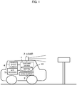
- FIG. 1 is a schematic configuration diagram of a driving support system according to the embodiments.
- the driving support system illustrated in FIG. 1 roughly includes an onboard device 1 loaded on a vehicle and performing a control on the driving support of the vehicle, a lidar (Light Detection and Ranging or Laser Illuminated Detection and Ranging) 2, a gyro sensor 3, a vehicle speed sensor 4 and a GPS receiver 5.
- an onboard device 1 loaded on a vehicle and performing a control on the driving support of the vehicle
- a lidar Light Detection and Ranging or Laser Illuminated Detection and Ranging
- gyro sensor 3 gyro sensor 3
- vehicle speed sensor 4 gyro sensor
- the onboard device 1 is electrically connected with the lidar 2, the gyro sensor 3, the vehicle speed sensor 4 and the GPS receiver 5, and estimates the position of the vehicle (referred to as "own vehicle position") on which the onboard device 1 is loaded based on the outputs of those elements. Then, on the basis of the estimation result of the own vehicle position, the onboard device 1 performs autonomous driving control of the vehicle to guide the vehicle along the route to the set destination.
- the onboard device 1 includes a map DB (DB: Database) 10 which includes voxel data.
- the voxel data is data in which the position information of stationary object(s) (stationary structure(s)) with respect to each voxel is recorded, wherein each voxel is a three-dimensional region into which space is regularly divided.
- the voxel data includes data which indicates, in a form of normal distribution, point cloud data of measured stationary object(s) situated in each voxel. As described below, the voxel data is used for a scan matching (collation) by use of NDT (Normal Distributions Transform).
- the lidar 2 emits pulse lasers within a predetermined angle range in a horizontal direction and a vertical direction to discretely measure the distance to an object existing in an external field and generates three-dimensional point cloud information indicating the position of the object.
- the lidar 2 includes an radiation unit which radiates the laser light while changing the radiation direction, a light receiving unit which receives the reflected light (scattering light) of the radiated laser light, and an output unit which outputs scan data based on the light receiving signal outputted by the light receiving unit.
- the scan data is generated based on the radiation direction corresponding to the laser light received by the light receiving unit and the response delay time of the laser light specified based on the light receiving signal.
- the lidar 2 supplies the output data to the onboard device 1, respectively.
- the onboard device 1 is an example of the "output device” according to the present invention and the lidar 2 is an example of the "measurement unit” according to the present invention.
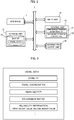
- FIG. 2 is a block diagram illustrating a functional configuration of the onboard device 1.
- the onboard device 1 mainly includes an interface 11, a storage (memory) unit 12, an input unit 14, a control unit 15 and an information output unit 16. These elements are connected with each other by a bus line.
- the interface 11 acquires the output data from the sensors such as the lidar 2, the gyro sensor 3, the vehicle speed sensor 4 and the GPS receiver 5, and supplies them to the control unit 15. Also, the interface 11 supplies the signals associated with the driving control of the vehicle, which is generated by the control unit 15, to an ECU (Electronic Control Unit) of the vehicle. A signal which the control unit 15 sends through the interface 11 to the ECU (electronic control device) of the vehicle is an example of the "control information" according to the present invention.
- the storage unit 12 stores programs executed by the control unit and information necessary for the control unit 15 to execute predetermined processing.
- the storage unit 12 stores the map DB 10 including voxel data. It is noted that the map DB 10 may be regularly updated.
- the control unit 15 receives partial map information regarding the area to which the own vehicle position belongs from a server device which manages map information and control unit 15 updates the map DB 10 by using it.
- the input unit 14 may be buttons, a touch panel, a remote controller or a voice input device to be operated by a user, and receives an input to designate a destination for the route search or an input designating ON or OFF of the autonomous driving.
- the information output unit 16 may be a display or a speaker for outputting information based on the control by the control unit 15.
- the control unit 15 includes a CPU for executing programs and controls the entire onboard device 1.
- the control unit 15 includes an own vehicle position estimation unit 17, and an autonomous driving control unit 18.
- the control unit 15 is an example of the "acquisition unit”, “position estimation unit”, “output unit” and "computer” which executes a program according to the present invention.
- the own vehicle position estimation unit 17 estimates the own vehicle position by performing the scan matching based on NDT on the basis of the point cloud data outputted by the lidar 2 and the voxel data corresponding to voxels where the point cloud data belongs.
- the autonomous driving control unit 18 refers to the map DB 10 and transmits signals necessary for the autonomous driving control to the vehicle based on the set route and the own vehicle position estimated by the own vehicle position estimation unit 17.
- the autonomous driving control unit 18 sets a target track based on the set route, and controls the position of the vehicle by transmitting the guide signal to the vehicle such that the own vehicle position estimated by the own vehicle position estimation unit 17 stays within a deviation width smaller than a predetermined width from the target track.
- the autonomous driving control unit 18 selects a voxel suitable for estimating the own vehicle position by referring to the voxel data.
- the autonomous driving control unit 18 considers the selected voxel as a voxel (referred to as "reference voxel Btag") subjected to a reference in estimating the own vehicle position. Then, the autonomous driving control unit 18 corrects the target track of the vehicle so that the vehicle moves on to a position suitable for detecting the reference voxel Btag by the lidar 2.
- FIG 3 schematically illustrates an example of the data structure of the voxel data.
- the voxel data includes information relating to parameters of a normal distribution for expressing the point cloud in each voxel.
- the voxel data includes the voxel ID, the voxel coordinates, the mean vector, the covariance matrix and the reliability information.
- the "voxel coordinates" herein indicates three-dimensional absolute coordinates of the reference position (such as central position) of each voxel. It is noted that each voxel is a cube or grid into which space is divided in a reticular pattern and the shape and the size thereof is preliminarily determined. Thus, it is possible to identify a region of a voxel by its voxel coordinates. It is also noted that the voxel coordinates may be used as a voxel ID.
- the "mean vector” and “covariance matrix” indicate the mean vector and the covariance matrix corresponding to parameters of the normal distribution which stands for the point cloud in a target voxel, respectively.
- the number of points included in the point cloud in the voxel k is also defined as "N k ".
- the mean vector " ⁇ k " and the covariance matrix "V k " are expressed as the following equation (1) and the equation (2), respectively.
- each of the mean vector and covariance matrix included in the voxel data is an example of the "position information of an object".
- the "reliability information" includes a first weight value and a second weight value, wherein the first weight value is a weight value based on the possibility of the occlusion (shielding by obstacle(s)) of the target voxel and the second weight value is a weight value based on the accuracy (correctness) of the voxel data (especially, the mean vector and covariance matrix) of the target voxel.
- the first weight value is an example of the "weight information" according to the present invention.
- the second weight value is determined based on: the accuracy of estimating the own vehicle position by a map maintenance vehicle which collects measurement data to be used for generating the voxel data; and the accuracy of the measurement by the measurement device (e.g., lidar) which output the above measurement data. For example, it firstly calculates, as a target accuracy, the square-root of sum of squares of the accuracy of the estimated own vehicle position of the map maintenance vehicle and the accuracy of the measurement by the measurement device, and then calculates the inverse of the square of above target accuracy as the second weight value.
- the higher the accuracy of the estimated own vehicle position of the map maintenance vehicle in collecting the measurement data is, the larger the second weight value becomes.
- the second weight value is determined on the basis of: the distance between the position indicated by the voxel coordinates of the target voxel and the own vehicle position of the map maintenance vehicle estimated at the time of travelling; and the accuracy of the estimated own vehicle position of the map maintenance vehicle.
- the second weight value is an example of the "accuracy information" according to the present invention.
- FIG. 4 illustrates an example of a positional relation between the map maintenance vehicle equipped with a lidar and objects situated within the range of measurement by the map maintenance vehicle.
- a low-rise construction 21 that is a feature (stationary object) in the vicinity of the road where the vehicle travels and there is also a high-rise construction 22 behind the low-rise construction 21.
- a person 23 who is riding on a bicycle in front of the low-rise construction 21.
- the map maintenance vehicle acquires, through a measurement device such as a lidar, the measurement data indicative of the positions in the frames 30 to 32.
- a portion of the low-rise construction 21 surrounded by the frame 30 is located at a relatively low position at which an occlusion by a moving body such as the person 23 is likely to occur.
- a relatively low value is set to the first weight value corresponding to the voxel data which overlaps with the frame 30.
- a portion of the low-rise construction 21 surrounded by the frame 30 is located relatively near the maintenance vehicle.
- the accuracy of the measurement data thereof acquired by the measurement device is expected to be high.
- a relatively high value indicative of a high degree of accuracy is set to the second weight value corresponding to the voxel data at the position which overlaps with the frame 30.
- a portion of the low-rise construction 21 surrounded by the frame 31 is located at such a position a little higher than the map maintenance vehicle.
- the portion in the frame 31 is located at a position a little far from the map maintenance vehicle and therefore the accuracy of the measurement data of the portion in the frame 31 acquired by the measurement device is a little lower than the accuracy of the measurement data of the portion in the frame 30.
- an intermediate value is set to the first weight value corresponding to the voxel data at the position which overlaps with the frame 31 and an intermediate value is also set to the second weight value corresponding thereto.
- a portion of the high-rise construction 22 surrounded by the frame 32 is located at a relatively high position at which an occlusion by a moving body such as the person 23 and other vehicles is not likely to occur.
- a relatively high value is set to the first weight value corresponding to the voxel data at the position which overlaps with the frame 32.
- the portion in the frame 32 is located at a position a little far from the map maintenance vehicle and therefore the accuracy of the measurement data of the portion in the frame 32 acquired by the measurement device such as a lidar is expected to be low.
- a relatively low value indicative of a low degree of accuracy is set to the second weight value corresponding to the voxel data at the position which overlaps with the frame 32.
- the first weight value increases with increasing height of the target voxel above the surface of the ground and the second weight value increases with decreasing distance between the target voxel and the map maintenance vehicle at the time of measurement thereof.
- the onboard device 1 calculates the value (evaluation value) of an evaluation function obtained through the NDT scan matching through weighting by use of reliability information included in the voxel data. Thereby, the onboard device 1 suitably increases the accuracy of the position estimation based on the NDT scan matching.
- the sign "t x " indicates the amount of movement in the x direction and the sign “t y “ indicates the amount of movement in the y direction and the sign " ⁇ " indicates rotational angle (i.e., yaw angle) on the x-y plane. It is noted that the amount of movement in the vertical direction, the pitch angle and the roll angle is vanishingly small though they are generated due to the road gradient and the vibration.
- the onboard device 1 calculates the evaluation function "E k " of the voxel k according to the following equation (4) and the total evaluation function "E” with respect to all voxels subjected to matching according to the following equation (5).
- the sign "M” indicates the number of the voxels subjected to matching and the sign "w k " indicates the first weight value corresponding to the voxel k.
- the sign " ⁇ k " indicates the accuracy information regarding the voxel k and "1 / ⁇ k 2 " indicates the second weight value corresponding to the voxel k.
- the second weight value 1 / ⁇ k 2 increases with increasing degree of accuracy (i.e., reliability).
- the evaluation function E k increases with the increasing first weight value w k and with the increasing second weight value 1 / ⁇ k 2 .
- the equation (4) is normalized by the point cloud number N k , the influence depending on the number of points of the point cloud in each voxel is reduced. It is noted that the coordinates of the point cloud data acquired by the lidar 2 is relative coordinates relative to the own vehicle position whereas the mean vector indicated by the voxel data is the absolute coordinates. Thus, at the time of calculation of the equation (4), for example, the coordinate transformation based on the own vehicle position according to the output of the GPS receiver 5 is applied to the coordinates of the point cloud data acquired by the lidar 2.
- the onboard device 1 weights each voxel depending on the degree of reliability of its voxel data (mean vector and covariance matrix). Thereby, the onboard device 1 puts a small weight on the evaluation function E k of the voxel with a low degree of reliability and suitably increases the accuracy of the estimated position based on the NDT matching.
- the onboard device 1 calculates such estimation parameters P that maximize the total evaluation function E by using any root-finding algorithm such as the Newton method. Then, the onboard device 1 estimates the own vehicle position with a high degree of accuracy by applying the estimation parameters P to the own vehicle position specified according to the output of the GPS receiver 5 and the like.
- FIG. 5A illustrates four voxels "B1" to "B4" adjacent to each other, wherein point cloud measured by lidar and the like mounted on a map maintenance vehicle are indicated by circles and two-dimensional normal distribution specified by parameters derived from the equation (1) and the equation (2) by use of the above point cloud is expressed by gradation.
- the mean and the variance of the normal distribution illustrated in FIG. 5A correspond to the mean vector and the covariance matrix of the voxel data, respectively.
- FIG. 5B illustrates, over the voxels illustrated in FIG. 5A , point cloud by stars which the onboard device 1 acquires by the lidar 2 at the time of travelling.
- the positions of the point cloud expressed by stars are adjusted to match the positions of voxels B1 to B4 on the basis of the own vehicle position estimated by use of the output of the GPS receiver 5.
- FIG. 5B there are differences between the point cloud (indicated by circles) measured by the map maintenance vehicle and the point cloud (indicated by stars) acquired by the onboard device 1.
- FIG. 5C illustrates the state of the voxels after the positions of the point cloud (indicated by stars) acquired by the onboard device 1 are shifted on the basis of the matching result of the NDT scan matching.
- the parameters P which maximize the total evaluation function E indicated by the equation (5) is firstly calculated on the basis of the mean and the variance of the normal distribution illustrated in FIGS. 5A and 5B and then the parameters P are applied to the point cloud expressed by stars illustrated in FIG. 5B .
- the differences between the point cloud (indicated by circles) measured by the map maintenance vehicle and the point cloud (indicated by stars) acquired by the onboard device 1 are suitably reduced.
- the first weight value and the second weight value are set to each voxel.
- the weight on a target voxel with increasing degree of reliability of the target voxel it is possible to increase the degree of the matching regarding voxels with a high degree of reliability.
- FIGS 6A to 6C a description will be given, with reference to FIGS 6A to 6C , of determination approaches of the first weight value on each of the voxels.
- FIG. 6A illustrates the matching result in cases where the first weight values corresponding to the voxels B1 to B4 are set to be equal, i.e., FIG. 6A is identical to FIG. 5C .
- FIG. 6B illustrates the matching result in cases where the first weight value of the voxel B1 is ten times as large as the first weight values of the other voxels.
- FIG. 6C illustrates the matching result in cases where the first weight value of the voxel B3 is ten times as large as the first weight values of the other voxels. For either cases, the second weight values are set to be equal.
- the evaluation functions E1 to E4 corresponding to voxels B1 to B4 and the total evaluation function E are as follows.
- the matching is performed so that the value of the evaluation function E1 corresponding to the voxel B1 becomes high and therefore the degree of the matching on the voxel B1 is increased.
- the difference between the circles and the stars in the voxels B1 becomes small.
- the evaluation functions E1 to E4 corresponding to voxels B1 to B4 and the total evaluation function E are as follows.
- the matching is performed so that the value of the evaluation function E3 corresponding to the voxel B3 becomes high and therefore the degree of the matching on the voxel B3 is increased.
- the difference between the circles and the stars in the voxels B3 becomes small.
- the first weight value it is possible to suitably increase the degree of the matching on such a voxel with little probability of occurrence of occlusion.
- the second weight value is also true for the second weight value.
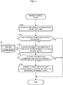
- FIG. 7 is a flowchart indicative of the procedure of the vehicle control based on the reference voxel Btag.
- the control unit 15 repeatedly executes the process of the flowchart in FIG. 7 .
- the own vehicle position estimation unit 17 estimates the own vehicle position based on the NDT matching (step S100).
- the own vehicle position estimation unit 17 acquires the vehicle speed from the vehicle speed sensor 4 and the angular speed in the yaw direction from the gyro sensor 3. Then, on the basis of the result of the acquisition, the own vehicle position estimation unit 17 calculates the distance of movement of the vehicle and the variation of the orientation of the vehicle. Thereafter, the own vehicle position estimation unit 17 calculates a predicted position by adding the calculated distance of movement and the variation of the orientation to the estimated own vehicle position (the initial value is, for example, output value of the GPS receiver 5) estimated at the preceding process time.
- the initial value is, for example, output value of the GPS receiver 5
- the own vehicle position estimation unit 17 acquires from the map DB 10 the voxel data corresponding to voxels in surroundings of the own vehicle position. Furthermore, on the basis of the predicted position, the own vehicle position estimation unit 17 divides (classifies) the scan data acquired from the lidar 2 per voxel where each point of the scan data belongs and computes the NDT scan matching by use of the evaluation functions. In this case, according to the equations (4) and (5), the own vehicle position estimation unit 17 calculates the evaluation functions E k and the total evaluation function E and thereby calculates the estimation parameters P which maximize the total evaluation function E. Then, the own vehicle position estimation unit 17 calculates the estimated own vehicle position at the current time by applying the estimation parameters P to the predicted position mentioned before.
- the autonomous driving control unit 18 determines whether or not the accuracy of the estimated position has decreased (step S101). For example, in cases where the total evaluation function E corresponding to the estimation parameters P calculated at step S100 is smaller than a predetermined threshold, the autonomous driving control unit 18 determines that the accuracy of the estimated position has decreased. When the autonomous driving control unit 18 determines that the accuracy of the estimated position has decreased (step S101; Yes), the autonomous driving control unit 18 moves on to the process at step S102. In contrast, when the autonomous driving control unit 18 determines that the accuracy of the estimated position has not decreased (step S101; No), the autonomous driving control unit 18 terminates the process of the flowchart.
- the autonomous driving control unit 18 acquires reliability information included in the voxel data corresponding to voxels around the route (step S102).
- the autonomous driving control unit 18 acquires the reliability information from the voxel data recorded in the map DB 10 which corresponds to such voxels that are situated within a predetermined distance from the estimated own vehicle position and within a predetermined distance from the road on the route in the direction of the width of the road.
- the autonomous driving control unit 18 determines whether or not there is any voxel suitable for estimating the own vehicle position (step S103). For example, the autonomous driving control unit 18 determines whether or not there is any voxel whose voxel data includes such reliability information that the first weight value is larger than a predetermined value and the second weight value is larger than a predetermined value.
- the autonomous driving control unit 18 determines an index value of the reliability based on an equation, table or the like by use of the first weight value and the second weight value as parameters, and then determines whether or not there is a voxel corresponding to the voxel data whose index value of the reliability based on its reliability information is larger than a predetermined value.
- the autonomous driving control unit 18 determines that there is any voxel suitable for estimating the own vehicle position (step S103; Yes).
- the autonomous driving control unit 18 considers the voxel suitable for estimating the own vehicle position as the reference voxel Btag. Then, the autonomous driving control unit 18 corrects the target track of the vehicle so as to pass the position suitable for measuring the reference voxel Btag (step S104). In this case, for example, the autonomous driving control unit 18 corrects the target track so that the vehicle passes the nearest position to the reference voxel Btag among positions at which the reference voxel Btag can be measured by the lidar 2 and at which an occlusion regarding the reference voxel Btag does not occur.
- the autonomous driving control unit 18 lets the vehicle approach the reference voxel Btag within the measurable range of the reference voxel Btag, thereby suitably increasing the detection accuracy of the reference voxel Btag by the lidar 2 and accuracy of the estimated position based on the NDT matching.
- the autonomous driving control unit 18 may select the nearest voxel to the estimated own vehicle position as the reference voxel Btag. In another example, the autonomous driving control unit 18 may select as the reference voxel Btag the voxel corresponding to the highest index value of the reliability calculated based on the first weight value and the second weight value indicated by its reliability information.
- step S103 when the autonomous driving control unit 18 determines that there is no voxel suitable for estimating the own vehicle position (step S103; No), the autonomous driving control unit 18 terminates the process of the flowchart.
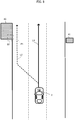
- FIG. 8 is a plane view of the vehicle on a road with three lanes each way in cases where there is a feature 40 on the left front side and where there is a feature 41 on the right front side.
- the solid arrow “L1" indicates the target track before the execution of the flowchart in FIG. 7 and the dashed arrow "L2" indicates the target track after the execution of the flowchart in FIG. 7 .
- the autonomous driving control unit 18 acquires the reliability information of the voxel data corresponding to voxels in the vicinity of the route which includes voxels overlapping with the feature 41 and the feature 42 (see step S102). Then, with reference to the reliability information of the acquired voxel data, the autonomous driving control unit 18 determines that the voxel B1 which includes a part of the feature 40 is suitable for estimating the own vehicle position (see step S103).
- the autonomous driving control unit 18 considers the voxel B1 as the reference voxel Btag and specifies a position "P1" at which the voxel B1 is suitably measured.
- the position P1 is the nearest position to the voxel B1 among positions on the road at which the voxel B1 can be measured by the lidar 2. Then, the autonomous driving control unit 18 shifts the target track indicated by the solid line L1 to the track passing the position P1 indicated by the dashed line L2.
- the autonomous driving control unit 18 moves the vehicle to the nearest lane to the reference voxel Btag or changes the travelling positions of the vehicle within the travelling lane to approach the reference voxel Btag.
- the autonomous driving control unit 18 can accurately measure, at close range by the lidar 2, the reference voxel Btag corresponding to the voxel data having a high degree of reliability, thereby suitably increasing the accuracy of estimated own vehicle position.
- the onboard device 1 when determining that the accuracy of the estimated position has decreased, acquires, from map DB 10 including voxel data, reliability information included in the voxel data corresponding to voxels around the route. Then, on the basis of the acquired reliability information, the onboard device 1 sets a voxel suitable for estimating the own vehicle position as the reference voxel Btag. Then, the onboard device 1 output, to an electronic control device of the vehicle, control information for correcting the target track of the vehicle so as for the vehicle to pass the position suitable for measuring the reference voxel Btag. Thereby, the onboard device 1 can suitably control the driving of the vehicle to increase the accuracy of the estimated position.
- a server device not shown may include the map DB 10.
- the onboard device 1 acquires necessary voxel data by communicating with the server device through a communication unit not shown.
- the first weight value and the second weight value are recorded as the reliability information. Instead, either one of the first weight value or the second weight value may be recorded as the reliability information in the voxel data.
- the onboard device 1 calculates the evaluation function E k and determines the reference voxel Btag. Even in this mode, as with the above embodiment, the onboard device 1 can increase the degree of the matching regarding voxels with a high degree of reliability. Besides, the onboard device 1 can select a voxel with a high degree of reliability as the reference voxel Btag thereby to perform a vehicle control for increasing the accuracy of the estimated own vehicle position.
- the configuration of the driving support system illustrated in FIG. 1 is an example, and the configuration of the driving support system to which the present invention can be applied is not limited to such a configuration illustrated in FIG. 1 .
- the driving support system may let an electronic control device execute the processes to be executed by the own vehicle position estimation unit 17 and autonomous driving control unit 18 of the onboard device 1.
- the map DB 10 is stored on the storage unit in the vehicle and the electronic control device of the vehicle may receive the update information regarding the map DB 10 from a server device not shown.
- the data structure of the voxel data is not limited to such a data structure including the mean vector and the covariance matrix as illustrated in FIG. 3 .
- the voxel data may include point cloud data, which is measured by the map maintenance vehicle and which is used for calculation of the mean vector and the covariance matrix, as it is.
- the point cloud data included in the voxel data is an example of the "position information of an object".
- any other scan matching method such as ICP (Iterative Closest Point) may be applied.
- the onboard device 1 by using the first weight value and the second weight value, puts weights on the evaluation function for evaluating the degree of the matching in each voxel. Thereby, it is possible to suitably increase the accuracy of the estimated position. If the accuracy of the estimated position has decreased, as with the embodiment, the onboard device 1 determines the reference voxel Btag based on the first weight value and the second weight value corresponding to voxels in the vicinity of the route and controls the vehicle based on the reference voxel Btag. Thereby, it is possible to suitably increase the accuracy of the estimated position.
Landscapes
- Engineering & Computer Science (AREA)
- Remote Sensing (AREA)
- Radar, Positioning & Navigation (AREA)
- Physics & Mathematics (AREA)
- General Physics & Mathematics (AREA)
- Automation & Control Theory (AREA)
- Theoretical Computer Science (AREA)
- Educational Technology (AREA)
- Educational Administration (AREA)
- Business, Economics & Management (AREA)
- Mathematical Physics (AREA)
- Navigation (AREA)
- Traffic Control Systems (AREA)
- Control Of Driving Devices And Active Controlling Of Vehicle (AREA)
Applications Claiming Priority (2)
| Application Number | Priority Date | Filing Date | Title |
|---|---|---|---|
| JP2017108582 | 2017-05-31 | ||
| PCT/JP2018/020358 WO2018221453A1 (fr) | 2017-05-31 | 2018-05-28 | Dispositif de sortie, procédé de commande, programme et support d'informations |
Publications (3)
| Publication Number | Publication Date |
|---|---|
| EP3633320A1 true EP3633320A1 (fr) | 2020-04-08 |
| EP3633320A4 EP3633320A4 (fr) | 2021-03-17 |
| EP3633320B1 EP3633320B1 (fr) | 2026-02-18 |
Family
ID=64456512
Family Applications (1)
| Application Number | Title | Priority Date | Filing Date |
|---|---|---|---|
| EP18809569.9A Active EP3633320B1 (fr) | 2017-05-31 | 2018-05-28 | Dispositif de sortie, procédé de commande, programme et support d'informations |
Country Status (4)
| Country | Link |
|---|---|
| US (1) | US11512962B2 (fr) |
| EP (1) | EP3633320B1 (fr) |
| JP (3) | JPWO2018221453A1 (fr) |
| WO (1) | WO2018221453A1 (fr) |
Cited By (2)
| Publication number | Priority date | Publication date | Assignee | Title |
|---|---|---|---|---|
| EP4025934A4 (fr) * | 2019-09-06 | 2023-08-16 | Ouster, Inc. | Traitement d'images lidar |
| EP4071738A4 (fr) * | 2019-12-02 | 2024-01-03 | Pioneer Corporation | Dispositif de traitement d'informations, procédé de commande, programme et support de stockage |
Families Citing this family (22)
| Publication number | Priority date | Publication date | Assignee | Title |
|---|---|---|---|---|
| US11073403B2 (en) * | 2018-01-12 | 2021-07-27 | Uatc, Llc | Map selection for vehicle pose system |
| US11822009B2 (en) * | 2018-03-28 | 2023-11-21 | Pioneer Corporation | Self-position estimation device, self-position estimation method, program, and recording medium |
| WO2020008458A2 (fr) * | 2018-07-02 | 2020-01-09 | Vayyar Imaging Ltd. | Systèmes et procédés pour cartographie d'environnement |
| CN114867989B (zh) | 2019-12-04 | 2024-12-27 | 日本先锋公司 | 信息处理设备、控制方法、程序产品和存储介质 |
| US11430087B2 (en) | 2019-12-20 | 2022-08-30 | Zoox, Inc. | Using maps comprising covariances in multi-resolution voxels |
| US11288861B2 (en) * | 2019-12-20 | 2022-03-29 | Zoox, Inc. | Maps comprising covariances in multi-resolution voxels |
| EP4078534A4 (fr) * | 2019-12-20 | 2024-01-03 | Zoox, Inc. | Cartes comprenant des covariances dans des voxels à résolutions multiples |
| US12001958B2 (en) * | 2020-03-19 | 2024-06-04 | Nvidia Corporation | Future trajectory predictions in multi-actor environments for autonomous machine |
| KR20230014724A (ko) * | 2020-05-22 | 2023-01-30 | 프로파운드 포지셔닝 인코포레이티드 | 차량 국부화 시스템 및 방법 |
| EP4246489B1 (fr) | 2020-11-13 | 2025-10-15 | Pioneer Corporation | Appareil de traitement d'informations, procédé de commande, programme et support de stockage |
| WO2022124115A1 (fr) | 2020-12-07 | 2022-06-16 | パイオニア株式会社 | Dispositif de traitement d'informations, procédé de commande, programme, et support d'enregistrement |
| JP7589035B2 (ja) * | 2020-12-07 | 2024-11-25 | パイオニア株式会社 | 情報処理装置、制御方法、プログラム及び記憶媒体 |
| EP4310550A4 (fr) | 2021-03-15 | 2025-01-08 | Pioneer Corporation | Appareil de traitement d'informations, procédé de commande, programme et support d'enregistrement |
| JP7569446B2 (ja) | 2021-03-15 | 2024-10-17 | パイオニア株式会社 | 情報処理装置、制御方法、プログラム及び記憶媒体 |
| WO2022208617A1 (fr) | 2021-03-29 | 2022-10-06 | パイオニア株式会社 | Structure de données de carte, dispositif de stockage, dispositif de traitement d'informations, procédé de commande, programme et support de stockage |
| US11915436B1 (en) * | 2021-08-30 | 2024-02-27 | Zoox, Inc. | System for aligning sensor data with maps comprising covariances |
| EP4400404A4 (fr) | 2021-09-10 | 2025-08-06 | Pioneer Corp | Dispositif de traitement d'informations, procédé de détermination, programme, et support de stockage |
| US20240400171A1 (en) | 2021-09-10 | 2024-12-05 | Pioneer Corporation | Server device, control method, program, and storage medium |
| JP7705945B2 (ja) | 2021-09-10 | 2025-07-10 | パイオニア株式会社 | 情報処理装置、判定方法、プログラム及び記憶媒体 |
| JP2023058961A (ja) * | 2021-10-14 | 2023-04-26 | パイオニア株式会社 | 情報処理装置、制御方法、プログラム及び記憶媒体 |
| US12546604B2 (en) | 2021-10-14 | 2026-02-10 | Pioneer Corporation | Information processing device, control method, program, and storage medium |
| US12397519B2 (en) | 2023-04-27 | 2025-08-26 | Vadient Optics, Llc | Multi-material halftoning of additively manufactured optics |
Family Cites Families (14)
| Publication number | Priority date | Publication date | Assignee | Title |
|---|---|---|---|---|
| JP4717650B2 (ja) * | 2006-02-02 | 2011-07-06 | 株式会社ゼンリン | 現在位置推定装置 |
| JP4816124B2 (ja) | 2006-02-20 | 2011-11-16 | 株式会社デンソー | 地図評価装置および地図評価方法 |
| JP4724043B2 (ja) * | 2006-05-17 | 2011-07-13 | トヨタ自動車株式会社 | 対象物認識装置 |
| JP4710740B2 (ja) | 2006-07-04 | 2011-06-29 | 株式会社デンソー | 位置情報利用装置 |
| JP4851874B2 (ja) * | 2006-07-11 | 2012-01-11 | 富士通株式会社 | 自己位置推定プログラム、自己位置推定方法および自己位置推定装置 |
| US8554478B2 (en) | 2007-02-23 | 2013-10-08 | Honeywell International Inc. | Correlation position determination |
| JP5802279B2 (ja) | 2011-11-22 | 2015-10-28 | 株式会社日立製作所 | 自律移動システム |
| JP5966747B2 (ja) | 2012-08-08 | 2016-08-10 | 日産自動車株式会社 | 車両走行制御装置及びその方法 |
| JP5880360B2 (ja) * | 2012-08-31 | 2016-03-09 | トヨタ自動車株式会社 | 運転支援システムおよび運転支援方法 |
| JP2014153192A (ja) * | 2013-02-08 | 2014-08-25 | Aisin Aw Co Ltd | 走行案内システム、走行案内方法及びコンピュータプログラム |
| US9062979B1 (en) * | 2013-07-08 | 2015-06-23 | Google Inc. | Pose estimation using long range features |
| JP6325806B2 (ja) | 2013-12-06 | 2018-05-16 | 日立オートモティブシステムズ株式会社 | 車両位置推定システム |
| JP2016149090A (ja) * | 2015-02-13 | 2016-08-18 | 株式会社リコー | 自律移動装置、自律移動システム、自律移動方法、およびプログラム |
| JP6870604B2 (ja) * | 2017-03-16 | 2021-05-12 | 株式会社デンソー | 自己位置推定装置 |
-
2018
- 2018-05-28 JP JP2019521203A patent/JPWO2018221453A1/ja active Pending
- 2018-05-28 EP EP18809569.9A patent/EP3633320B1/fr active Active
- 2018-05-28 WO PCT/JP2018/020358 patent/WO2018221453A1/fr not_active Ceased
- 2018-05-28 US US16/618,085 patent/US11512962B2/en active Active
-
2023
- 2023-02-28 JP JP2023029777A patent/JP2023073257A/ja active Pending
-
2024
- 2024-09-13 JP JP2024158762A patent/JP2024169478A/ja active Pending
Cited By (3)
| Publication number | Priority date | Publication date | Assignee | Title |
|---|---|---|---|---|
| EP4025934A4 (fr) * | 2019-09-06 | 2023-08-16 | Ouster, Inc. | Traitement d'images lidar |
| US12578475B2 (en) | 2019-09-06 | 2026-03-17 | Ouster, Inc. | Processing of LIDAR images |
| EP4071738A4 (fr) * | 2019-12-02 | 2024-01-03 | Pioneer Corporation | Dispositif de traitement d'informations, procédé de commande, programme et support de stockage |
Also Published As
| Publication number | Publication date |
|---|---|
| US20200271454A1 (en) | 2020-08-27 |
| WO2018221453A1 (fr) | 2018-12-06 |
| JPWO2018221453A1 (ja) | 2020-03-26 |
| EP3633320B1 (fr) | 2026-02-18 |
| EP3633320A4 (fr) | 2021-03-17 |
| JP2024169478A (ja) | 2024-12-05 |
| US11512962B2 (en) | 2022-11-29 |
| JP2023073257A (ja) | 2023-05-25 |
Similar Documents
| Publication | Publication Date | Title |
|---|---|---|
| EP3633320B1 (fr) | Dispositif de sortie, procédé de commande, programme et support d'informations | |
| EP3633655B1 (fr) | Dispositif de génération de carte, procédé de commande, programme et support de stockage | |
| EP1537440B1 (fr) | Système d'évaluation de l'incurvation d'une route et d'estimation de l'état cible d'une automobile | |
| JP6721784B2 (ja) | 情報処理装置、サーバ装置、制御方法、プログラム及び記憶媒体 | |
| US12146746B2 (en) | Information processing device, control method, program and storage medium | |
| US12099361B2 (en) | Output device, control method, program and storage medium for control of a moving body based on road marking detection accuracy | |
| US10814788B2 (en) | Recognized-region estimation device, recognized-region estimation method, and recognized-region estimation program | |
| EP3872454A1 (fr) | Dispositif de calcul de précision de mesure, dispositif d'estimation de position d'hôte, procédé de commande, programme et support de mémorisation | |
| WO2018221455A1 (fr) | Dispositif de mise à jour, procédé de commande, programme et support de stockage | |
| EP4071738A1 (fr) | Dispositif de traitement d'informations, procédé de commande, programme et support de stockage | |
| US11420632B2 (en) | Output device, control method, program and storage medium | |
| JP7566451B2 (ja) | 静止物データ生成装置、制御方法、プログラム及び記憶媒体 | |
| JP2025123340A (ja) | 情報処理装置、地図生成装置、記憶装置、制御方法及びプログラム | |
| EP4246489B1 (fr) | Appareil de traitement d'informations, procédé de commande, programme et support de stockage | |
| US12248070B2 (en) | Information processing device, control method, program and storage medium | |
| JP7589035B2 (ja) | 情報処理装置、制御方法、プログラム及び記憶媒体 | |
| EP4257926A1 (fr) | Dispositif de traitement d'informations, procédé de commande, programme, et support d'enregistrement | |
| JP2020034452A (ja) | 位置推定装置、制御方法、プログラム及び記憶媒体 |
Legal Events
| Date | Code | Title | Description |
|---|---|---|---|
| STAA | Information on the status of an ep patent application or granted ep patent |
Free format text: STATUS: THE INTERNATIONAL PUBLICATION HAS BEEN MADE |
|
| PUAI | Public reference made under article 153(3) epc to a published international application that has entered the european phase |
Free format text: ORIGINAL CODE: 0009012 |
|
| STAA | Information on the status of an ep patent application or granted ep patent |
Free format text: STATUS: REQUEST FOR EXAMINATION WAS MADE |
|
| 17P | Request for examination filed |
Effective date: 20191216 |
|
| AK | Designated contracting states |
Kind code of ref document: A1 Designated state(s): AL AT BE BG CH CY CZ DE DK EE ES FI FR GB GR HR HU IE IS IT LI LT LU LV MC MK MT NL NO PL PT RO RS SE SI SK SM TR |
|
| AX | Request for extension of the european patent |
Extension state: BA ME |
|
| DAV | Request for validation of the european patent (deleted) | ||
| DAX | Request for extension of the european patent (deleted) | ||
| RIC1 | Information provided on ipc code assigned before grant |
Ipc: G05D 1/02 20200101ALI20210201BHEP Ipc: G01C 21/30 20060101AFI20210201BHEP Ipc: G08G 1/16 20060101ALI20210201BHEP Ipc: B60W 30/14 20060101ALI20210201BHEP Ipc: G09B 29/10 20060101ALI20210201BHEP |
|
| A4 | Supplementary search report drawn up and despatched |
Effective date: 20210211 |
|
| RIC1 | Information provided on ipc code assigned before grant |
Ipc: B60W 30/14 20060101ALI20210205BHEP Ipc: G01C 21/30 20060101AFI20210205BHEP Ipc: G08G 1/16 20060101ALI20210205BHEP Ipc: G05D 1/02 20200101ALI20210205BHEP Ipc: G09B 29/10 20060101ALI20210205BHEP |
|
| STAA | Information on the status of an ep patent application or granted ep patent |
Free format text: STATUS: EXAMINATION IS IN PROGRESS |
|
| 17Q | First examination report despatched |
Effective date: 20230328 |
|
| GRAP | Despatch of communication of intention to grant a patent |
Free format text: ORIGINAL CODE: EPIDOSNIGR1 |
|
| STAA | Information on the status of an ep patent application or granted ep patent |
Free format text: STATUS: GRANT OF PATENT IS INTENDED |
|
| RIC1 | Information provided on ipc code assigned before grant |
Ipc: G01C 21/30 20060101AFI20250819BHEP Ipc: B60W 30/14 20060101ALI20250819BHEP Ipc: G09B 29/10 20060101ALI20250819BHEP Ipc: G08G 1/16 20060101ALI20250819BHEP Ipc: G05D 1/00 20060101ALI20250819BHEP |
|
| INTG | Intention to grant announced |
Effective date: 20250911 |
|
| GRAS | Grant fee paid |
Free format text: ORIGINAL CODE: EPIDOSNIGR3 |
|
| GRAA | (expected) grant |
Free format text: ORIGINAL CODE: 0009210 |
|
| STAA | Information on the status of an ep patent application or granted ep patent |
Free format text: STATUS: THE PATENT HAS BEEN GRANTED |
|
| AK | Designated contracting states |
Kind code of ref document: B1 Designated state(s): AL AT BE BG CH CY CZ DE DK EE ES FI FR GB GR HR HU IE IS IT LI LT LU LV MC MK MT NL NO PL PT RO RS SE SI SK SM TR |
|
| REG | Reference to a national code |
Ref country code: CH Ref legal event code: F10 Free format text: ST27 STATUS EVENT CODE: U-0-0-F10-F00 (AS PROVIDED BY THE NATIONAL OFFICE) Effective date: 20260218 Ref country code: GB Ref legal event code: FG4D |
|
| REG | Reference to a national code |
Ref country code: DE Ref legal event code: R096 Ref document number: 602018089244 Country of ref document: DE |
|
| REG | Reference to a national code |
Ref country code: DE Ref legal event code: R084 Ref document number: 602018089244 Country of ref document: DE |
|
| REG | Reference to a national code |
Ref country code: IE Ref legal event code: FG4D |