EP3671546A1 - Procédé et système de détermination des repères dans un environnement d'un véhicule - Google Patents
Procédé et système de détermination des repères dans un environnement d'un véhicule Download PDFInfo
- Publication number
- EP3671546A1 EP3671546A1 EP19217199.9A EP19217199A EP3671546A1 EP 3671546 A1 EP3671546 A1 EP 3671546A1 EP 19217199 A EP19217199 A EP 19217199A EP 3671546 A1 EP3671546 A1 EP 3671546A1
- Authority
- EP
- European Patent Office
- Prior art keywords
- subset
- landmark
- data
- environmental data
- unit
- Prior art date
- Legal status (The legal status is an assumption and is not a legal conclusion. Google has not performed a legal analysis and makes no representation as to the accuracy of the status listed.)
- Pending
Links
Images

Classifications
-
- G—PHYSICS
- G06—COMPUTING OR CALCULATING; COUNTING
- G06F—ELECTRIC DIGITAL DATA PROCESSING
- G06F18/00—Pattern recognition
- G06F18/20—Analysing
- G06F18/24—Classification techniques
-
- G—PHYSICS
- G06—COMPUTING OR CALCULATING; COUNTING
- G06V—IMAGE OR VIDEO RECOGNITION OR UNDERSTANDING
- G06V20/00—Scenes; Scene-specific elements
- G06V20/50—Context or environment of the image
- G06V20/56—Context or environment of the image exterior to a vehicle by using sensors mounted on the vehicle
-
- G—PHYSICS
- G01—MEASURING; TESTING
- G01C—MEASURING DISTANCES, LEVELS OR BEARINGS; SURVEYING; NAVIGATION; GYROSCOPIC INSTRUMENTS; PHOTOGRAMMETRY OR VIDEOGRAMMETRY
- G01C21/00—Navigation; Navigational instruments not provided for in groups G01C1/00 - G01C19/00
- G01C21/26—Navigation; Navigational instruments not provided for in groups G01C1/00 - G01C19/00 specially adapted for navigation in a road network
- G01C21/28—Navigation; Navigational instruments not provided for in groups G01C1/00 - G01C19/00 specially adapted for navigation in a road network with correlation of data from several navigational instruments
- G01C21/30—Map- or contour-matching
-
- G—PHYSICS
- G06—COMPUTING OR CALCULATING; COUNTING
- G06F—ELECTRIC DIGITAL DATA PROCESSING
- G06F18/00—Pattern recognition
- G06F18/20—Analysing
- G06F18/21—Design or setup of recognition systems or techniques; Extraction of features in feature space; Blind source separation
- G06F18/214—Generating training patterns; Bootstrap methods, e.g. bagging or boosting
-
- G—PHYSICS
- G06—COMPUTING OR CALCULATING; COUNTING
- G06V—IMAGE OR VIDEO RECOGNITION OR UNDERSTANDING
- G06V10/00—Arrangements for image or video recognition or understanding
- G06V10/70—Arrangements for image or video recognition or understanding using pattern recognition or machine learning
- G06V10/82—Arrangements for image or video recognition or understanding using pattern recognition or machine learning using neural networks
-
- G—PHYSICS
- G06—COMPUTING OR CALCULATING; COUNTING
- G06V—IMAGE OR VIDEO RECOGNITION OR UNDERSTANDING
- G06V20/00—Scenes; Scene-specific elements
- G06V20/10—Terrestrial scenes
-
- G—PHYSICS
- G06—COMPUTING OR CALCULATING; COUNTING
- G06V—IMAGE OR VIDEO RECOGNITION OR UNDERSTANDING
- G06V20/00—Scenes; Scene-specific elements
- G06V20/50—Context or environment of the image
- G06V20/56—Context or environment of the image exterior to a vehicle by using sensors mounted on the vehicle
- G06V20/58—Recognition of moving objects or obstacles, e.g. vehicles or pedestrians; Recognition of traffic objects, e.g. traffic signs, traffic lights or roads
-
- G—PHYSICS
- G06—COMPUTING OR CALCULATING; COUNTING
- G06V—IMAGE OR VIDEO RECOGNITION OR UNDERSTANDING
- G06V20/00—Scenes; Scene-specific elements
- G06V20/50—Context or environment of the image
- G06V20/56—Context or environment of the image exterior to a vehicle by using sensors mounted on the vehicle
- G06V20/58—Recognition of moving objects or obstacles, e.g. vehicles or pedestrians; Recognition of traffic objects, e.g. traffic signs, traffic lights or roads
- G06V20/582—Recognition of moving objects or obstacles, e.g. vehicles or pedestrians; Recognition of traffic objects, e.g. traffic signs, traffic lights or roads of traffic signs
-
- G—PHYSICS
- G06—COMPUTING OR CALCULATING; COUNTING
- G06V—IMAGE OR VIDEO RECOGNITION OR UNDERSTANDING
- G06V20/00—Scenes; Scene-specific elements
- G06V20/50—Context or environment of the image
- G06V20/56—Context or environment of the image exterior to a vehicle by using sensors mounted on the vehicle
- G06V20/588—Recognition of the road, e.g. of lane markings; Recognition of the vehicle driving pattern in relation to the road
-
- G—PHYSICS
- G06—COMPUTING OR CALCULATING; COUNTING
- G06V—IMAGE OR VIDEO RECOGNITION OR UNDERSTANDING
- G06V2201/00—Indexing scheme relating to image or video recognition or understanding
- G06V2201/08—Detecting or categorising vehicles
-
- G—PHYSICS
- G06—COMPUTING OR CALCULATING; COUNTING
- G06V—IMAGE OR VIDEO RECOGNITION OR UNDERSTANDING
- G06V2201/00—Indexing scheme relating to image or video recognition or understanding
- G06V2201/09—Recognition of logos
Definitions
- the present invention relates to a method for determining landmarks in the surroundings of a vehicle. It also relates to a system for determining landmarks in the surroundings of a vehicle.
- Modern vehicles include a variety of driving functions that allow certain driving tasks to be carried out at least partially automatically.
- An essential prerequisite for this is a precise knowledge of the surroundings of the vehicle, in particular its position relative to objects that are relevant for the control.
- a variety of different sensors can be used to capture this knowledge.
- the evaluation of the data to be processed in this way continues to be a major challenge in known systems.
- WO 2018/104563 A2 a method for video-based position determination is known, semantic segmentation being carried out. Objects are identified and used to detect landmarks. Visual odometry is performed.
- the US 2018/0089505 A1 proposes a method for object detection in an image, in which probabilities for the identification of certain object candidates are determined. Scaling and determining threshold values for these probabilities are intended to prevent false detections.
- the present invention has for its object to provide a method and a system that allows a particularly efficient determination of landmarks.
- first environmental data are recorded. At least a subset of the first environmental data is determined and the subset is assigned a category from a large number of different categories. Depending on a landmark type, a category is determined and landmark detection is carried out, which is limited to the subset of the particular category.
- the landmark detection is advantageously carried out particularly quickly and with optimal use of the resources in the vehicle. Furthermore, false detections can be avoided and the output data for the detection of landmarks can be optimized for the implementation of the detection. The method also ensures improved maintainability and testability, since incorrect landmark detection can be avoided in unsuitable areas.
- the occurrence of landmarks is not searched for when determining the subset of the first environmental data, but areas can be determined and categorized, for example, in which specific types of landmarks are to be sought or are not to be expected.
- the term “landmarks” includes features and / or patterns in an environment that can be identified and to which at least location information can be assigned. These can be, for example, characteristic points or objects that are arranged at certain positions in the environment.
- the landmarks can have semantics, that is to say they can also be identified as such for human perception as identifiable objects or features. Landmarks are also included that do not have any semantics, but rather represent, for example, abstract patterns that can be detected by pattern recognition.
- Landmark types can be assigned to the landmarks in a manner known per se, in particular on the basis of geometric properties or on the basis of a semantics which are connected to the landmarks. For example, lane markings, posts, signs, structures, elements of vegetation or structures of traffic management systems can each be defined as specific types of landmarks. Furthermore, several special types of landmarks, such as “stop signs” and “no parking signs”, can be assigned to a more general or generic type of landmark, such as “signs”. In particular, the Process associated with each landmark at least one landmark type. A specific landmark can also be assigned to several special and / or general landmark types.
- Landmark types can be, for example, edges or other parts of structures, markings on a roadway, traffic guidance devices or two-dimensional codes. For example, lane markings, turning arrows, parking space markings or similar floor markings, posts, poles, columns, traffic or other signs, signaling systems or traffic lights, building edges or corners, pipes, QR or barcodes as well as alphanumeric representations can be detected.
- further features can be used for localization, which designate characteristic, localizable points in a geographical environment of the own position. In general, these are features that can be identified using a pattern recognition method and to which position data can be assigned.
- the first environmental data are recorded using a camera.
- existing devices of the vehicle can advantageously be used to record relevant environmental data.
- the camera captures image data, in particular as a chronologically ordered sequence of individual images, which can be combined to form video data.
- the environmental data can also be recorded in another manner known per se, for example by means of sensors of a vehicle such as optical, radar, lidar or ultrasonic sensors.
- This can be, for example, a permanently installed sensor for traffic monitoring that records and provides environmental data.
- an external server can be used, which receives, stores and provides relevant environmental data if required.
- Such environmental data can, for example, be recorded by certain or a large number of vehicles and devices along a route and transmitted to the server.
- radar sensors are sensors of a first type and ultrasound sensors are sensors of another type.
- a further differentiation can be made, for example a differentiation between different ones Types of radar sensors that differ from one another, for example, in their construction and / or a special type of data processing.
- the environmental data are also recorded in a specific detection area, which can be caused in particular by the sensor type and / or a specific activation of the sensors.
- the detection space can be defined, for example, by an angle in space and a distance or radius relative to the vehicle.
- a plurality of sensors, in particular of a common sensor type, can furthermore be used in combination in order to arrive at an enlarged detection space by combining the recorded environmental data.
- a camera can capture image data from a certain point of view and a combination of several cameras can cover a larger detection area and, for example, enable an all-round view of the vehicle.
- the landmark detection is limited to a subset of the acquired first environmental data and the volume of the environmental data to be analyzed is reduced in this way.
- a semantic segmentation of the recorded first environmental data can be carried out, in which a classification is carried out for subsets of the environmental data and a category is assigned to them.
- classification is made for each pixel of captured image data. Pixels that are assigned to a common category can be combined into individual subsets or segments, especially if they form a coherent surface.
- the subset is determined by means of a machine learning method.
- the determination of the subset and possibly also the assignment of a category can advantageously be implemented in a particularly flexible and reliable manner.
- a trained classifier is used, which is designed on the basis of training data for recognizing certain categories on the basis of the recorded environmental data.
- Methods known per se from the field of machine learning or artificial intelligence are used, for example a neural network, a deep learning system or a suitable statistical method.
- the categories include a floor, a roadway, vegetation, a built-up area, a pillar, a standing or moving vehicle or a person.
- the categories therefore essentially correspond to object classes.
- the categories assigned to the subsets are therefore advantageously particularly well suited to determining suitable subsets of the environmental data for detecting certain types of landmarks.
- the landmark detection is carried out using a heuristic procedure.
- the detection is advantageously carried out in a known and safe manner on the basis of predetermined detector modules which include a reliably recognizable characterization of the landmarks.
- the detection takes place in particular on the basis of fixed, predetermined rules for the detection of certain features of landmarks of a specific landmark type.
- Landmarks of a certain type of landmark can be described using a pattern which is suitable for detecting a landmark of the particular type of landmark in surrounding data.
- the information used for this can include, for example, a mathematically formulated description for recognizing a pattern with which a landmark or a feature of the environment is represented in the signals of a sensor.
- geometric properties of objects of a landmark type can be described, but also material properties, such as reflectance values or mathematical functions, such as gradients of light-dark transitions.
- Such descriptions for the detection of landmarks of a landmark type are generally sensor-specific, so that it is sensible for the different types of sensors to be provided with their own pattern descriptions for the detection.
- the detection of patterns in an image of an optical camera differs from the detection within a point cloud that a laser scanner detects.
- the data recorded by a specific sensor type can be processed in such a way that the same detection method as for data of another sensor type can be applied to them.
- the landmarks are detected on the basis of the surrounding data, for example using pattern recognition methods, by means of which the landmarks are used, for example, in camera images or laser point clouds can be recognized.
- So-called “detector modules” are used for this. These are, in particular, software modules that include, for example, a storable file.
- the detector modules are designed in such a way that they can be used to detect landmarks of a specific landmark type based on the recorded environmental data. In particular, the detector modules can be designed specifically for the detection of a specific landmark type. It can be provided that each detected landmark is assigned at least one landmark type.
- a rough classification of areas within the environmental data is first carried out, in particular using a method of artificial intelligence, in which landmarks of a specific landmark type can then be specifically detected, a heuristic method being used in particular for the detection .
- other subsets can be excluded on the basis of the categories assigned to them when detecting the landmarks for a particular landmark type, for example because no occurrence of a particular landmark is to be expected in certain areas of the environmental data.
- the subset therefore corresponds in particular to a selected area, for example a so-called region of interest (ROI) for the search for landmarks of a specific landmark type.
- ROI region of interest
- landmarks of the "lane markings” landmark type are expected on a lane, that is to say in a subset of the surrounding data, which belongs, for example, to the "lane” category. Conversely, landmarks of this type of landmark are not expected in areas that have been categorized as "stationary vehicle", for example. In this way, for example, false detections due to reflections of a landmark can be avoided.
- a spatial area in the surroundings of the vehicle is determined on the basis of the determined subset, and further ambient data are recorded on surfaces, wherein a different sensor type is used to record the further environmental data than for recording the first environmental data.
- the landmark detection is also carried out on the basis of the further environmental data and as a function of the spatial area. This advantageously makes it possible to also use the information obtained on the basis of the first environmental data for environmental data acquired by other sensors.
- image data are acquired as the first environmental data.
- a subset is initially determined and assigned to a category in such a way that a specific landmark type is detected on the basis of this subset.
- the subset corresponds to a spatial area in the vehicle environment in which data is also acquired using other sensors of a different sensor type. For example, data from a lidar sensor can be recorded there.
- filtering can now be carried out in such a way that the landmark detection is limited to the same spatial area on the basis of the lidar data or that further spatial areas are covered by the landmark detection be exempted.
- the additional environmental data are only recorded in the spatial area, for example by controlling a detection unit of the other sensor type in such a way that the detection is limited to the spatial area.
- the amount of data obtained can advantageously be reduced.
- computing times and latency times when data is transferred, for example inside the vehicle or to an external unit, are reduced.
- spatial areas can also be stored over a longer period of time and used when acquiring the additional environmental data, for example in further time steps.
- a detection area of a sensor or the area relevant for the detection of a specific landmark type can be stored by a control device of the sensor and used for filtering the detected data.
- the subset is transmitted from a mobile unit, in particular from the vehicle, to an external unit and the landmark detection is carried out by the external unit.
- the external unit can be, for example, an external server or be a back-end device that is data-technically coupled to the mobile unit.
- the landmark detection can advantageously be carried out by a unit which has larger resources than the mobile unit.
- the method of the invention enables a considerable reduction in the data to be transmitted, since only the subset of a suitable category has to be transmitted for the landmark detection. This means that the available bandwidth can be used particularly efficiently, especially when transmitting data via radio waves.
- the external unit can also have continuously updated detectors for different types of landmarks and therefore also allow, for example, the detection of such landmarks for which a complex software update would otherwise have to be carried out in the mobile unit.
- request data are generated by the external unit and the subset is transmitted to the external unit depending on the request data.
- the external unit can advantageously request the required data in a targeted manner.
- the request data include in particular information about a category on the basis of which the subset to be transferred is formed.
- the external unit can first define a specific landmark type for which a landmark detection is to be carried out, and the suitable data can be requested from the mobile unit by the request data.
- position data for landmarks of the landmark type are determined and output in the landmark detection.
- a pose of the vehicle is determined on the basis of the position data. The determination of such a pose is, for example, a prerequisite for performing a partially or fully automatic travel of the vehicle.
- Position data are assigned to the detected landmarks, in particular a position or a pose in a coordinate system being assigned to the landmarks. This can be done in the detection step or in a separate step.
- the position or pose can be determined in particular as a function of the assigned landmark type, for example by defining specific axes for determining the position of the landmark for certain landmark types or by using certain sections of a landmark to determine the position of the landmark.
- a global or relative coordinate system are used, for example a relative system relative to a detection unit or a vehicle.
- further features can be determined for the detected landmarks, such as their size and shape, color, a parameter for describing dynamic features, or by evaluating a label.
- the pose of the vehicle includes information about its position and orientation in a particular coordinate system, such as a global coordinate system or a relative coordinate system.
- map data are recorded, which also include position data for the landmarks, that is, information about their position in a coordinate system. It can be a global or relative coordinate system.
- the position data relate in particular to poses of the landmarks, that is to say a combination of their position and their position, described, for example, on the basis of their orientation relative to other landmarks.
- an arrow can point in a certain direction in space
- a post can have a certain length and run at a certain angle to a carriageway
- an edge of a building can be in a certain position relative to a carriageway.
- a transformation is determined by means of which the positions of the landmarks in the vehicle system can be transformed into the coordinate system of the map data. This transformation results in the position and in particular also the orientation of the vehicle in the coordinate system of the map data.
- the landmark detection is carried out using a machine learning process.
- Machine learning is advantageously used not only to determine the subset, but also to detect the landmarks. By performing the landmark detection on the basis of the subset of the surrounding data, machine learning can also be restricted to smaller amounts of data.
- a training is carried out on the basis of example data sets, in which the system automatically learns to recognize certain patterns for individual landmarks. Unlike a heuristic method, no fixed systems of rules for recognizing the landmarks are specified here, but the detection is based on the data records for the training.
- the method is also carried out in two stages if both the determination of the subset and the landmark detection are carried out using a machine learning method: First, the segmentation of the environmental data is carried out, combined with the assignment of categories to subsets of the environmental data. The landmark detection is then carried out, taking into account only those subsets to which suitable categories for the landmark types to be detected have been assigned.
- training data are generated on the basis of the subset and a training for the landmark detection is carried out on the basis of the machine learning method on the basis of the training data.
- the training can thus advantageously take place in a particularly targeted manner.
- the training can be carried out, for example, by an external unit, which carries out the landmark detection.
- the categorization of the subsets of the environmental data makes it easier to provide relevant training data.
- the automatic detection of the landmarks can be further improved in this way.
- detector modules for landmarks of a specific landmark type can be generated or updated on the basis of the training data.
- the landmark detection can then again be carried out in a different way than a machine learning method, in particular using a heuristic method.
- the detector modules can in particular be completely newly generated by machine learning, in particular in order to be able to detect new types of landmarks, or an improved detector module can be generated.
- a sliding window method can be used for landmark detection, in which a "window" is used to rasterize the surrounding data to detect the landmarks.
- the size and, if necessary, also the shape of such a window must be such that the landmarks to be detected can be found therein.
- the system according to the invention of the type mentioned at the outset comprises a recording unit for recording first environmental data and a segmentation unit for determining at least a subset of the first environmental data and for assigning a category from a large number of different categories to the specific subset.
- the system further comprises an arithmetic unit for determining a category depending on a landmark type and for performing a landmark detection for the landmark type.
- the computing unit is set up to carry out the landmark detection restricted to the subset of the specific category.
- the system according to the invention is particularly designed to implement the method according to the invention described above.
- the system thus has the same advantages as the method according to the invention.
- the detection unit comprises a camera.
- sensors can be provided, for example based on radar, lidar, ultrasound or various optical sensors, for example infrared, time-of-flight or stereo cameras.
- sensor systems already widely used in vehicles can advantageously be used.
- a spatial area is determined on the basis of the determined subset and the environmental data recorded by the detection unit is filtered.
- it is determined in particular which subsets of environmental data that have been recorded by other sensor types correspond to the specific spatial area for the subsets.
- a spatial area is determined on the basis of image data, for which a lidar sensor also records ambient data.
- the environmental data of the further sensor type can also be filtered so that the environmental data recorded there can be used for the landmark detection. In contrast, environmental data recorded in other areas can be rejected.
- a control device controls the segmentation unit in such a way that only the subset of the recorded environmental data is transmitted to the computing unit.
- several subsets which are determined for a landmark type on the basis of the categories assigned to them, are transmitted to the computing unit.
- the control device comprises the segmentation device and already determines the subset on the level of the detection and the sensors used for this purpose.
- the system further comprises an interface to an external unit and the system is set up to transmit the specific subset to the external unit, the external unit being set up to carry out the landmark detection on the basis of the subset.
- the external unit then transmits information about detected landmarks to the interface.
- the complex step of landmark detection can thereby advantageously be carried out by the external unit, for example an external server. Determining a relevant subset of the environmental data helps to ensure that as little data as possible has to be transmitted via the interface, so that the available bandwidth can be used particularly efficiently.
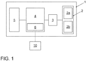
- the vehicle 1 comprises a detection unit 2 with a camera 2a and a lidar unit 2b.
- the detection unit is coupled to a segmentation unit 3, which in turn is coupled to a computing unit 4.
- the vehicle 1 also includes a driver assistance system 5, which is also coupled to the computing unit 4.
- the computing unit also comprises an interface 6, via which a separable, wireless data connection to an external unit 10 can be established.
- the interface 6 is set up in a manner known per se to establish a connection to a network, in particular the Internet, via a mobile radio network via a mobile radio network.
- the external unit 10 is designed as a back-end server.
- the segmentation unit 3 is comprised by a control unit of the detection unit 2 and in particular integrated into the detection unit 2.
- a control device can also be formed integrally with the camera 2a and / or the lidar unit 2b.
- the segmentation unit 3 is designed to carry out a comprehensive preprocessing of the recorded environmental data before, if appropriate, a transfer to the computing unit 4 takes place.
- first environmental data are acquired by the acquisition unit 2.
- the first environmental data comprise image data that are captured by the camera 2a.
- the acquired first environmental data are transmitted to the segmentation unit 3 in a step 21.
- the segmentation unit uses the image data to determine subsets of the first environmental data.
- a machine learning method is used for this. Any suitable method from the field of artificial intelligence and neural networks can be used.
- a trained classifier is used, which was formed from training data to assign the correct categories to the pixels of the surrounding data.
- semantic segmentation is carried out for this.
- each pixel of the image data is classified and assigned to a category.
- Contiguous areas of pixels of a common category are called segments and form a common subset of the surrounding data.
- At least one category is assigned to each of these subsets.
- the categories assigned in the exemplary embodiment relate to properties of different areas in the surroundings of the vehicle 1 and indicate, for example, whether a pixel is assigned to a floor, a roadway, vegetation, a built-up area, a column, a stationary or moving vehicle or a person . Alternatively or additionally, other categories can be provided.
- the specific subsets of certain categories are transmitted from the segmentation unit 3 to the computing unit 4. This is in particular a reduced amount of data compared to the recorded environmental data. This leads to an improved utilization of the bandwidth available in vehicle 1 for the transmission of data.
- the decision for which categories the relevant subsets should be transferred depends on the types of landmarks to be determined. It can be assumed that landmarks of a certain type can be found in areas of a certain category. For example, lane markings on a lane should be recognized, but not their mirror images, for example on a reflective surface of a parked vehicle. On the other hand, traffic signs are expected in an edge area next to a road, so that the road surface is not relevant in this case and a corresponding subset can be excluded from the detection.
- the entire recorded environmental data together with information about the previously determined subsets and their categories are transmitted to the computing unit 4.
- the computing unit 4 can determine which partial quantities are to be taken into account for each landmark type to be detected.
- landmarks are determined by the computing unit 4. This is done on the basis of those subsets of the environmental data which have been assigned suitable categories for certain types of landmarks.
- detector modules are used which, in the exemplary embodiment, are designed as software modules for detecting landmarks of a specific type of landmark based on the surrounding data.
- heuristic methods are used in which the detector modules comprise a predetermined control structure for recognizing landmarks of a certain type.
- the detections can be carried out using a machine learning method or a mixture of different methods can be used, for example by using a machine learning method to generate or update a detector module.
- the following types of landmarks are provided: road markings, traffic signs, light signal systems, QR codes, posts or other features in the vicinity of the vehicle 1.
- the landmarks are detected, their type of landmarks are determined and, depending on the particular type of landmarks, characteristics of the individual landmarks are determined determined. This includes in particular position information relative to vehicle 1.
- the detection of the landmarks of a specific type of landmark is carried out only on the basis of subsets of the recorded environmental data, to which a suitable category has been assigned.
- information about the detected landmarks is transmitted to the driver assistance system 5, which in the exemplary embodiment carries out a landmark-based position determination and uses the information obtained in this way for autonomous control of the vehicle 1.
- map data are recorded, which include position information and possibly further data about landmarks in the vicinity of vehicle 1.
- a transformation is carried out, by means of which the position data of the landmarks detected by vehicle 1 are transferred into the coordinate system of the map data.
- the position of the vehicle 1 is also determined on the basis of this transformation, in particular in connection with its orientation in the coordinate system of the map data.
- information about certain relevant categories of the subsets of the environmental data is generated and transmitted to the segmentation unit 3. For example, it is determined which types of landmarks are to be detected and which categories are relevant for this.
- the partial quantities can be determined specifically for certain categories and the relevant partial quantities can be transmitted to the computing unit 4 in a targeted manner. The volume of the data to be transmitted can be reduced in this way.
- further environmental data are recorded by the lidar unit 2b.
- the information determined by the segmentation unit 3 in step 21 is now used to use this additional environmental data particularly efficiently. For this purpose, it is determined which spatial areas in the vicinity of the vehicle correspond to the subsets of the image data which the camera 2a has captured and which in step 21 were categorized. For example, on the basis of the image data captured by the camera 2a, it is determined in which spatial area, relative to the vehicle 1, the road surface or another vehicle is located. The same category is assigned to this spatial area, and when evaluating the additional environmental data that were recorded using a different sensor type, partial quantities are again determined that correspond to the spatial area.
- subsets are only carried out on the basis of the image data, while the subsets of the other environmental data recorded in the same spatial areas are assigned the same categories. Depending on the categories assigned to them, these subsets are also transmitted to the computing unit 4 and used for landmark detection.
- the landmarks are at least partially detected by the external unit 10.
- the environmental data are not completely transmitted to the external unit 10 via the interface 6, also because the bandwidth available for this is typically limited. Instead, only those subsets of the environmental data are transmitted which have been determined by the segmentation unit 3 and have been assigned to a category suitable for the desired landmarks.
- the external unit 10 can also generate request data, which for example include information about relevant categories and / or desired landmarks. These request data are received by the vehicle 1 via the interface 6 and the acquisition of the environmental data by the acquisition unit 2 and / or the generation of the subsets by the segmentation unit 3 are carried out in such a way that suitable subsets of certain categories can be provided for the desired landmarks. These suitable subsets are then transmitted to the external unit 10.
- request data for example include information about relevant categories and / or desired landmarks.
- the external unit can transmit the specific landmarks, in particular with position information, to the vehicle 1.
- the external unit 10 can carry out a position determination for the vehicle 1, for example as described above for the driver assistance system 5.
- the subsets of the environmental data are used to provide training data for a machine learning method, for example for training a classifier.
- the subsets with suitable categories are used and it is first determined in which subsets Landmarks of the desired type are available. Various learning methods known per se can then be used.
- image data are captured by means of the camera 2a.
- image data are processed by means of semantic segmentation.
- an artificial intelligence method is used and a trained classifier assigns a category to the pixels of the image data.
- the segmented image data are then fed to further image processing in a step 32 or are used to filter sensor data in a step 33.
- subsets of the recorded environmental data are generated.
- image data acquired in step 30 is assumed, but also further environmental data, which are acquired in step 34, for example by a radar or lidar sensor.
- spatial areas in the surroundings of vehicle 1 are determined on the basis of the segmented image data, and the categories assigned to the segments are also assigned to those data which are detected by other sensors in the same spatial areas.
- subsets of the recorded radar or lidar data are determined, which were recorded in the area of a roadway or another vehicle.
- filtered sensor data are generated that only comprise those subsets that are assigned to specific categories.
- the filtered sensor data are therefore particularly suitable, in particular, for the detection of certain types of landmarks, for example if only certain types of landmarks are to be detected in a specific driving situation. For example, when parking vehicle 1 automatically, parking space markings on a floor surface can be relevant as landmarks.
- the sensor data are processed further, in particular a landmark detection being carried out.
- a landmark detection positions of individual landmarks in particular in the vicinity of vehicle 1 can be determined and used to determine the position or pose of the vehicle 1.
- a support function can also be carried out, such as a parking garage pilot or a parking assistant.
- the lidar unit 2b specifically detects the additional environmental data in specific spatial areas to which specific categories are assigned and which are to be used for landmark detection.
- the sensor unit can be controlled, for example, by a control device in such a way that the detection space assigned to it is adapted in accordance with the spatial areas.
Landscapes
- Engineering & Computer Science (AREA)
- Theoretical Computer Science (AREA)
- General Physics & Mathematics (AREA)
- Physics & Mathematics (AREA)
- Multimedia (AREA)
- Evolutionary Computation (AREA)
- Data Mining & Analysis (AREA)
- Radar, Positioning & Navigation (AREA)
- Remote Sensing (AREA)
- Computer Vision & Pattern Recognition (AREA)
- Artificial Intelligence (AREA)
- Evolutionary Biology (AREA)
- Bioinformatics & Computational Biology (AREA)
- Bioinformatics & Cheminformatics (AREA)
- Life Sciences & Earth Sciences (AREA)
- General Engineering & Computer Science (AREA)
- Health & Medical Sciences (AREA)
- Software Systems (AREA)
- Medical Informatics (AREA)
- General Health & Medical Sciences (AREA)
- Databases & Information Systems (AREA)
- Computing Systems (AREA)
- Automation & Control Theory (AREA)
- Traffic Control Systems (AREA)
- Navigation (AREA)
- Image Analysis (AREA)
Applications Claiming Priority (1)
| Application Number | Priority Date | Filing Date | Title |
|---|---|---|---|
| DE102018133441.9A DE102018133441A1 (de) | 2018-12-21 | 2018-12-21 | Verfahren und System zum Bestimmen von Landmarken in einer Umgebung eines Fahrzeugs |
Publications (1)
| Publication Number | Publication Date |
|---|---|
| EP3671546A1 true EP3671546A1 (fr) | 2020-06-24 |
Family
ID=68944342
Family Applications (1)
| Application Number | Title | Priority Date | Filing Date |
|---|---|---|---|
| EP19217199.9A Pending EP3671546A1 (fr) | 2018-12-21 | 2019-12-17 | Procédé et système de détermination des repères dans un environnement d'un véhicule |
Country Status (4)
| Country | Link |
|---|---|
| US (1) | US11371851B2 (fr) |
| EP (1) | EP3671546A1 (fr) |
| CN (1) | CN111353522B (fr) |
| DE (1) | DE102018133441A1 (fr) |
Cited By (4)
| Publication number | Priority date | Publication date | Assignee | Title |
|---|---|---|---|---|
| US11810459B1 (en) | 2022-05-09 | 2023-11-07 | Aptiv Technologies Limited | Vehicle localization based on radar detections in garages |
| US11988741B2 (en) | 2020-12-17 | 2024-05-21 | Aptiv Technologies AG | Vehicle routing based on availability of radar-localization objects |
| US12105192B2 (en) | 2020-12-17 | 2024-10-01 | Aptiv Technologies AG | Radar reference map generation |
| US12174641B2 (en) | 2020-12-17 | 2024-12-24 | Aptiv Technologies AG | Vehicle localization based on radar detections |
Families Citing this family (7)
| Publication number | Priority date | Publication date | Assignee | Title |
|---|---|---|---|---|
| US11265480B2 (en) * | 2019-06-11 | 2022-03-01 | Qualcomm Incorporated | Systems and methods for controlling exposure settings based on motion characteristics associated with an image sensor |
| US12392628B2 (en) * | 2020-06-30 | 2025-08-19 | Lyft, Inc. | Localization based on multi-collect fusion |
| US12087004B2 (en) | 2020-06-30 | 2024-09-10 | Lyft, Inc. | Multi-collect fusion |
| DE102021117741A1 (de) | 2021-07-09 | 2023-01-12 | Cariad Se | Selbstlokalisierung eines Fahrzeugs in einer Parkinfrastruktur |
| DE102021117742B4 (de) | 2021-07-09 | 2025-05-15 | Cariad Se | Selbstlokalisierung eines Fahrzeugs in einer Parkinfrastruktur mit selektiver Sensoraktivierung |
| DE102023206713A1 (de) | 2023-07-14 | 2025-01-16 | Robert Bosch Gesellschaft mit beschränkter Haftung | Verfahren zum Übertragen von Umfelddaten und Umfeldsensorvorrichtung |
| JP2025019916A (ja) * | 2023-07-28 | 2025-02-07 | 株式会社東芝 | 測距支援装置、測距システムおよび測距支援方法 |
Citations (3)
| Publication number | Priority date | Publication date | Assignee | Title |
|---|---|---|---|---|
| US20180089505A1 (en) | 2016-09-23 | 2018-03-29 | Samsung Electronics Co., Ltd. | System and method for deep network fusion for fast and robust object detection |
| US9953236B1 (en) | 2017-03-10 | 2018-04-24 | TuSimple | System and method for semantic segmentation using dense upsampling convolution (DUC) |
| WO2018104563A2 (fr) | 2016-12-09 | 2018-06-14 | Tomtom Global Content B.V. | Procédé et système de positionnement et de cartographie reposant sur la vidéo |
Family Cites Families (14)
| Publication number | Priority date | Publication date | Assignee | Title |
|---|---|---|---|---|
| US8811663B2 (en) * | 2011-01-05 | 2014-08-19 | International Business Machines Corporation | Object detection in crowded scenes |
| US9235781B2 (en) * | 2013-08-09 | 2016-01-12 | Kabushiki Kaisha Toshiba | Method of, and apparatus for, landmark location |
| JP6227165B2 (ja) * | 2014-12-10 | 2017-11-08 | 三菱電機株式会社 | 画像処理装置及び車載表示システム及び表示装置及び画像処理方法及び画像処理プログラム |
| CA2992080C (fr) * | 2015-07-13 | 2020-01-28 | Nissan Motor Co., Ltd. | Dispositif de reconnaissance de feu de circulation et procede de reconnaissance de feu de circulation |
| CA2997171C (fr) * | 2015-08-28 | 2019-10-22 | Nissan Motor Co., Ltd. | Dispositif d'estimation de position de vehicule, procede d'estimation de position de vehicule |
| KR101772178B1 (ko) * | 2015-12-04 | 2017-08-25 | 엘지전자 주식회사 | 차량용 랜드마크 검출 장치 및 방법 |
| US10503168B1 (en) * | 2016-01-22 | 2019-12-10 | State Farm Mutual Automotive Insurance Company | Autonomous vehicle retrieval |
| DE102016204206A1 (de) * | 2016-03-15 | 2017-09-21 | Robert Bosch Gmbh | Verfahren zum Detektieren einer Verschmutzung einer optischen Komponente eines Umfeldsensors zum Erfassen eines Umfelds eines Fahrzeugs, Verfahren zum maschinellen Anlernen eines Klassifikators und Detektionssystem |
| DE102016205867A1 (de) * | 2016-04-08 | 2017-10-12 | Robert Bosch Gmbh | Verfahren zur Bestimmung einer Pose eines wenigstens teilautomatisiert fahrenden Fahrzeugs mittels verschiedener Landmarkentypen |
| DE102016210534A1 (de) * | 2016-06-14 | 2017-12-14 | Bayerische Motoren Werke Aktiengesellschaft | Verfahren zum Klassifizieren einer Umgebung eines Fahrzeugs |
| US10037471B2 (en) * | 2016-07-05 | 2018-07-31 | Nauto Global Limited | System and method for image analysis |
| US20180053102A1 (en) * | 2016-08-16 | 2018-02-22 | Toyota Jidosha Kabushiki Kaisha | Individualized Adaptation of Driver Action Prediction Models |
| US10421436B2 (en) * | 2017-03-24 | 2019-09-24 | Toyota Motor Engineering & Manufacturing North America, Inc. | Systems and methods for surveillance of a vehicle using camera images |
| US10417816B2 (en) * | 2017-06-16 | 2019-09-17 | Nauto, Inc. | System and method for digital environment reconstruction |
-
2018
- 2018-12-21 DE DE102018133441.9A patent/DE102018133441A1/de not_active Withdrawn
-
2019
- 2019-12-17 EP EP19217199.9A patent/EP3671546A1/fr active Pending
- 2019-12-20 CN CN201911325605.7A patent/CN111353522B/zh active Active
- 2019-12-23 US US16/724,468 patent/US11371851B2/en active Active
Patent Citations (3)
| Publication number | Priority date | Publication date | Assignee | Title |
|---|---|---|---|---|
| US20180089505A1 (en) | 2016-09-23 | 2018-03-29 | Samsung Electronics Co., Ltd. | System and method for deep network fusion for fast and robust object detection |
| WO2018104563A2 (fr) | 2016-12-09 | 2018-06-14 | Tomtom Global Content B.V. | Procédé et système de positionnement et de cartographie reposant sur la vidéo |
| US9953236B1 (en) | 2017-03-10 | 2018-04-24 | TuSimple | System and method for semantic segmentation using dense upsampling convolution (DUC) |
Non-Patent Citations (2)
| Title |
|---|
| LI LIU ET AL: "Deep Learning for Generic Object Detection: A Survey", INTERNATIONAL JOURNAL OF COMPUTER VISION., vol. 128, no. 2, 6 September 2018 (2018-09-06), US, pages 261 - 318, XP055676998, ISSN: 0920-5691, DOI: 10.1007/s11263-019-01247-4 * |
| QI CHARLES R ET AL: "Frustum PointNets for 3D Object Detection from RGB-D Data", 2018 IEEE/CVF CONFERENCE ON COMPUTER VISION AND PATTERN RECOGNITION, IEEE, 18 June 2018 (2018-06-18), pages 918 - 927, XP033476053, DOI: 10.1109/CVPR.2018.00102 * |
Cited By (5)
| Publication number | Priority date | Publication date | Assignee | Title |
|---|---|---|---|---|
| US11988741B2 (en) | 2020-12-17 | 2024-05-21 | Aptiv Technologies AG | Vehicle routing based on availability of radar-localization objects |
| US12105192B2 (en) | 2020-12-17 | 2024-10-01 | Aptiv Technologies AG | Radar reference map generation |
| US12174641B2 (en) | 2020-12-17 | 2024-12-24 | Aptiv Technologies AG | Vehicle localization based on radar detections |
| US11810459B1 (en) | 2022-05-09 | 2023-11-07 | Aptiv Technologies Limited | Vehicle localization based on radar detections in garages |
| EP4276493A1 (fr) * | 2022-05-09 | 2023-11-15 | Aptiv Technologies Limited | Localisation de véhicule basée sur des détections radar dans des garages |
Also Published As
| Publication number | Publication date |
|---|---|
| US20200200545A1 (en) | 2020-06-25 |
| DE102018133441A1 (de) | 2020-06-25 |
| CN111353522A (zh) | 2020-06-30 |
| CN111353522B (zh) | 2024-03-08 |
| US11371851B2 (en) | 2022-06-28 |
Similar Documents
| Publication | Publication Date | Title |
|---|---|---|
| EP3671546A1 (fr) | Procédé et système de détermination des repères dans un environnement d'un véhicule | |
| EP3105547B1 (fr) | Procédé de détermination de la position absolue d'une unité mobile et unité mobile | |
| DE60126382T2 (de) | Verfahren und Gerät zur Erkennung von Gegenständen | |
| DE102017130488A1 (de) | Verfahren zur Klassifizierung von Parklücken in einem Umgebungsbereich eines Fahrzeugs mit einem neuronalen Netzwerk | |
| DE102014223363B4 (de) | Verfahren und Vorrichtung zur Lokalisation eines Kraftfahrzeugs in einer ortsfesten Referenzkarte | |
| DE102021111325B4 (de) | Verfahren und Assistenzeinrichtung zum Unterstützen eines Fahrbetriebs eines Kraftfahrzeugs und Kraftfahrzeug | |
| EP3491417B1 (fr) | Procédé et système de détection de points de repère dans un environnement de circulation d'une unité mobile | |
| DE102015203016B4 (de) | Verfahren und Vorrichtung zur optischen Selbstlokalisation eines Kraftfahrzeugs in einem Umfeld | |
| WO2020016385A1 (fr) | Procédé et système destiné à déterminer une position d'un véhicule | |
| DE102018104270A1 (de) | Verfahren zum Vorhersagen des Verhaltens mindestens eines Fußgängers | |
| DE102017203276B4 (de) | Verfahren und Vorrichtung zur Ermittlung einer Trajektorie in Off-road-Szenarien | |
| EP1298454A2 (fr) | Procédé de reconnaissance et de suivi d'objets | |
| WO2013029722A2 (fr) | Procédé de représentation de l'environnement | |
| EP2033165B1 (fr) | Procede pour la detection d'un espace de circulation | |
| DE102017216802A1 (de) | Verfahren und vorrichtung zum erkennen von fahrspuren, fahrerassistenzsystem und fahrzeug | |
| DE102018121008A1 (de) | Kreuzverkehrserfassung unter verwendung von kameras | |
| DE102021206075A1 (de) | Fahrzeuglokalisierung als Mitfahrgelegenheit und Insassenidentifikation für autonome Fahrzeuge | |
| DE102017123226A1 (de) | Verfahren zum Bestimmen einer kritischen Höhe eines vorausliegenden Streckenabschnitts für ein Fahrzeug, das ein Zugfahrzeug und einen Anhänger umfasst | |
| EP3663881B1 (fr) | Procédé de commande d'un véhicule autonome en fonction des vecteurs de mouvement estimés | |
| WO2022079162A1 (fr) | Système et procédé d'annotation de données radar de voiture | |
| DE102022212343A1 (de) | Autonom-fahrsystem | |
| DE102018121866A1 (de) | Verfahren zur Tiefenabschätzung von zweidimensionalen Sensordaten | |
| DE102021207609A1 (de) | Verfahren zur Kennzeichnung eines Bewegungsweges | |
| DE102020211023B4 (de) | Verfahren und Vorrichtung zur Umfeldwahrnehmung eines Umfeldes eines zumindest teilautomatisiert fahrenden Fahrzeugs | |
| EP3671125B1 (fr) | Système de détection de la position et procédé de fonctionnement d'un système de détection de la position pour une unité mobile |
Legal Events
| Date | Code | Title | Description |
|---|---|---|---|
| PUAI | Public reference made under article 153(3) epc to a published international application that has entered the european phase |
Free format text: ORIGINAL CODE: 0009012 |
|
| STAA | Information on the status of an ep patent application or granted ep patent |
Free format text: STATUS: THE APPLICATION HAS BEEN PUBLISHED |
|
| AK | Designated contracting states |
Kind code of ref document: A1 Designated state(s): AL AT BE BG CH CY CZ DE DK EE ES FI FR GB GR HR HU IE IS IT LI LT LU LV MC MK MT NL NO PL PT RO RS SE SI SK SM TR |
|
| AX | Request for extension of the european patent |
Extension state: BA ME |
|
| STAA | Information on the status of an ep patent application or granted ep patent |
Free format text: STATUS: REQUEST FOR EXAMINATION WAS MADE |
|
| 17P | Request for examination filed |
Effective date: 20210111 |
|
| RBV | Designated contracting states (corrected) |
Designated state(s): AL AT BE BG CH CY CZ DE DK EE ES FI FR GB GR HR HU IE IS IT LI LT LU LV MC MK MT NL NO PL PT RO RS SE SI SK SM TR |
|
| STAA | Information on the status of an ep patent application or granted ep patent |
Free format text: STATUS: EXAMINATION IS IN PROGRESS |
|
| 17Q | First examination report despatched |
Effective date: 20220221 |
|
| REG | Reference to a national code |
Ref country code: DE Ref legal event code: R079 Free format text: PREVIOUS MAIN CLASS: G06K0009000000 Ipc: G06V0020560000 |
|
| GRAP | Despatch of communication of intention to grant a patent |
Free format text: ORIGINAL CODE: EPIDOSNIGR1 |
|
| STAA | Information on the status of an ep patent application or granted ep patent |
Free format text: STATUS: GRANT OF PATENT IS INTENDED |
|
| RIC1 | Information provided on ipc code assigned before grant |
Ipc: G06V 20/56 20220101AFI20260122BHEP Ipc: G06V 10/82 20220101ALI20260122BHEP Ipc: G06V 20/58 20220101ALI20260122BHEP |
|
| INTG | Intention to grant announced |
Effective date: 20260213 |