EP3671547B1 - Positionnement automatique en 3d des panneaux routiers détectés en images 2d - Google Patents
Positionnement automatique en 3d des panneaux routiers détectés en images 2d Download PDFInfo
- Publication number
- EP3671547B1 EP3671547B1 EP19217361.5A EP19217361A EP3671547B1 EP 3671547 B1 EP3671547 B1 EP 3671547B1 EP 19217361 A EP19217361 A EP 19217361A EP 3671547 B1 EP3671547 B1 EP 3671547B1
- Authority
- EP
- European Patent Office
- Prior art keywords
- frustum
- data
- sign
- sighting
- value
- Prior art date
- Legal status (The legal status is an assumption and is not a legal conclusion. Google has not performed a legal analysis and makes no representation as to the accuracy of the status listed.)
- Active
Links
Images




Classifications
-
- G—PHYSICS
- G01—MEASURING; TESTING
- G01S—RADIO DIRECTION-FINDING; RADIO NAVIGATION; DETERMINING DISTANCE OR VELOCITY BY USE OF RADIO WAVES; LOCATING OR PRESENCE-DETECTING BY USE OF THE REFLECTION OR RERADIATION OF RADIO WAVES; ANALOGOUS ARRANGEMENTS USING OTHER WAVES
- G01S17/00—Systems using the reflection or reradiation of electromagnetic waves other than radio waves, e.g. lidar systems
- G01S17/88—Lidar systems specially adapted for specific applications
- G01S17/93—Lidar systems specially adapted for specific applications for anti-collision purposes
- G01S17/931—Lidar systems specially adapted for specific applications for anti-collision purposes of land vehicles
-
- G—PHYSICS
- G06—COMPUTING OR CALCULATING; COUNTING
- G06T—IMAGE DATA PROCESSING OR GENERATION, IN GENERAL
- G06T7/00—Image analysis
- G06T7/10—Segmentation; Edge detection
- G06T7/11—Region-based segmentation
-
- G—PHYSICS
- G06—COMPUTING OR CALCULATING; COUNTING
- G06V—IMAGE OR VIDEO RECOGNITION OR UNDERSTANDING
- G06V10/00—Arrangements for image or video recognition or understanding
- G06V10/70—Arrangements for image or video recognition or understanding using pattern recognition or machine learning
- G06V10/77—Processing image or video features in feature spaces; using data integration or data reduction, e.g. principal component analysis [PCA] or independent component analysis [ICA] or self-organising maps [SOM]; Blind source separation
- G06V10/80—Fusion, i.e. combining data from various sources at the sensor level, preprocessing level, feature extraction level or classification level
- G06V10/803—Fusion, i.e. combining data from various sources at the sensor level, preprocessing level, feature extraction level or classification level of input or preprocessed data
-
- G—PHYSICS
- G06—COMPUTING OR CALCULATING; COUNTING
- G06V—IMAGE OR VIDEO RECOGNITION OR UNDERSTANDING
- G06V20/00—Scenes; Scene-specific elements
- G06V20/50—Context or environment of the image
- G06V20/56—Context or environment of the image exterior to a vehicle by using sensors mounted on the vehicle
- G06V20/58—Recognition of moving objects or obstacles, e.g. vehicles or pedestrians; Recognition of traffic objects, e.g. traffic signs, traffic lights or roads
- G06V20/582—Recognition of moving objects or obstacles, e.g. vehicles or pedestrians; Recognition of traffic objects, e.g. traffic signs, traffic lights or roads of traffic signs
-
- G—PHYSICS
- G06—COMPUTING OR CALCULATING; COUNTING
- G06V—IMAGE OR VIDEO RECOGNITION OR UNDERSTANDING
- G06V20/00—Scenes; Scene-specific elements
- G06V20/50—Context or environment of the image
- G06V20/56—Context or environment of the image exterior to a vehicle by using sensors mounted on the vehicle
- G06V20/588—Recognition of the road, e.g. of lane markings; Recognition of the vehicle driving pattern in relation to the road
-
- G—PHYSICS
- G01—MEASURING; TESTING
- G01S—RADIO DIRECTION-FINDING; RADIO NAVIGATION; DETERMINING DISTANCE OR VELOCITY BY USE OF RADIO WAVES; LOCATING OR PRESENCE-DETECTING BY USE OF THE REFLECTION OR RERADIATION OF RADIO WAVES; ANALOGOUS ARRANGEMENTS USING OTHER WAVES
- G01S17/00—Systems using the reflection or reradiation of electromagnetic waves other than radio waves, e.g. lidar systems
- G01S17/88—Lidar systems specially adapted for specific applications
- G01S17/89—Lidar systems specially adapted for specific applications for mapping or imaging
-
- G—PHYSICS
- G01—MEASURING; TESTING
- G01S—RADIO DIRECTION-FINDING; RADIO NAVIGATION; DETERMINING DISTANCE OR VELOCITY BY USE OF RADIO WAVES; LOCATING OR PRESENCE-DETECTING BY USE OF THE REFLECTION OR RERADIATION OF RADIO WAVES; ANALOGOUS ARRANGEMENTS USING OTHER WAVES
- G01S7/00—Details of systems according to groups G01S13/00, G01S15/00, G01S17/00
- G01S7/48—Details of systems according to groups G01S13/00, G01S15/00, G01S17/00 of systems according to group G01S17/00
- G01S7/4802—Details of systems according to groups G01S13/00, G01S15/00, G01S17/00 of systems according to group G01S17/00 using analysis of echo signal for target characterisation; Target signature; Target cross-section
-
- G—PHYSICS
- G06—COMPUTING OR CALCULATING; COUNTING
- G06F—ELECTRIC DIGITAL DATA PROCESSING
- G06F18/00—Pattern recognition
- G06F18/20—Analysing
- G06F18/25—Fusion techniques
- G06F18/251—Fusion techniques of input or preprocessed data
-
- G—PHYSICS
- G06—COMPUTING OR CALCULATING; COUNTING
- G06T—IMAGE DATA PROCESSING OR GENERATION, IN GENERAL
- G06T2207/00—Indexing scheme for image analysis or image enhancement
- G06T2207/10—Image acquisition modality
- G06T2207/10028—Range image; Depth image; 3D point clouds
-
- G—PHYSICS
- G06—COMPUTING OR CALCULATING; COUNTING
- G06T—IMAGE DATA PROCESSING OR GENERATION, IN GENERAL
- G06T2207/00—Indexing scheme for image analysis or image enhancement
- G06T2207/20—Special algorithmic details
- G06T2207/20112—Image segmentation details
-
- G—PHYSICS
- G06—COMPUTING OR CALCULATING; COUNTING
- G06T—IMAGE DATA PROCESSING OR GENERATION, IN GENERAL
- G06T2207/00—Indexing scheme for image analysis or image enhancement
- G06T2207/30—Subject of image; Context of image processing
- G06T2207/30248—Vehicle exterior or interior
- G06T2207/30252—Vehicle exterior; Vicinity of vehicle
-
- G—PHYSICS
- G06—COMPUTING OR CALCULATING; COUNTING
- G06V—IMAGE OR VIDEO RECOGNITION OR UNDERSTANDING
- G06V2201/00—Indexing scheme relating to image or video recognition or understanding
- G06V2201/12—Acquisition of 3D measurements of objects
Definitions
- the following disclosure relates to the detection of road signs, and more particularly to the detection of road signs in an image based on a joint analysis of the image and associated point cloud.
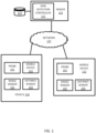
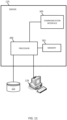
- the vehicles 124 may be directly connected to the server 125 or through an associated mobile device 122.
- a map developer system including the server 125 and a geographic database 123, exchanges (e.g., receives and sends) data from the vehicles 124.
- the mobile devices 122 may include local databases corresponding to a local map, which may be modified according to the server 125.
- the local map may include a subset of the geographic database 123 and are updated or changed as the vehicles 124 travel.
- the mobile devices 122 may be standalone devices such as smartphones or devices integrated with vehicles.
- the local maps are modified according to data collected by the mobile device 122 or vehicle 124.
- the collected data is transferred to the server 125 for augmenting the geographic database 123. Additional, different, or fewer components may be included.
- Each vehicle 124 and/or mobile device 122 may include position circuitry such as one or more processors or circuits for generating probe data.
- the probe data may be generated by receiving GNSS signals and comparing the GNSS signals to a clock to determine the absolute or relative position of the vehicle 124 and/or mobile device 122.
- the probe data may be generated by receiving radio signals or wireless signals (e.g., cellular signals, the family of protocols known as WiFi or IEEE 802.11, the family of protocols known as Bluetooth, or another protocol) and comparing the signals to a pre-stored pattern of signals (e.g., radio map).
- the mobile device 122 may act as probe 101 for determining the position or the mobile device 122 and the probe 101 may be separate devices.
- the vehicle 124 may include one or more distance data detection device or sensor 103, such as a light detection and ranging (LiDAR) device.
- the distance data detection sensor 103 may generate point cloud data.
- the distance data detection sensor 103 may include a laser range finder that rotates a mirror directing a laser to the surroundings or vicinity of the collection vehicle on a roadway or another collection device on any type of pathway or stationary position. Other types of pathways may be substituted for the roadway in any embodiment described herein.
- Each image or point cloud may be associated with or stored with a timestamp and/or a location stamp based on the time and location that the image was collected.
- the images may be collected in response to time intervals (e.g., every 0.5 second, every second) as the vehicle travels along the roadway such that the series of images are at a predetermined time interval.
- the geographic distance between images varies as the speed of the camera or collection vehicle changes.
- the timestamp may be omitted when the images are collected at the predetermined time interval.
- the images may be collected in response to location intervals (e.g., every meter, every 10 feet) as the vehicle travels along the roadway such that the series of images are at a predetermined location interval.
- the time between images varies as the speed of the camera or the collection vehicle changes.
- the location stamp may be omitted when the images are collected at the predetermined location interval.
- These geometric descriptors may be treated as a probability of the neighborhood being linear, planar, or volumetric.
- the dimensionality of the neighborhood may be defined as the ⁇ d that has the maximum probability.
- An entropy function (e.g., the Shannon entropy function) may be applied to these probabilities to quantify the uncertainty of the shape of the neighborhood. The lower the entropy, the more certain the dimensionality of the points.
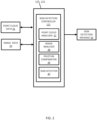
- the image analyzer 38 may utilize a variety of image processing techniques for identifying signs in the image 41.
- Example image processing techniques include an edge detection, feature extraction or transforms (e.g., scale invariant feature transform), vector classification, or neural network.
- edge detection the brightness, or another image characteristic, of adjacent image pixels in the probe data.
- feature extraction or transforms the image is analyzed to identify particular features that indicate the layout.
- vector classification may compare vectors representative of boundary elements to vectors from the image.
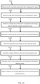
- the sign detector 40 is configured to provide a location for the sign detection in response to the comparison of the sighting frustum to the sign position candidate.
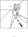
- the location includes the coordinates from the point cloud data 31 where the sign position candidates match the sighting frustum 50. If a sighting is correct (i.e. there really is a sign at the position and the 2D detector or the image analyzer 38 has correctly identified its location in the image), then the surface it is painted on must lie in the sighting frustum 50, and should have been identified as a position candidate.
- the coordinates where the sign position candidates match the sighting frustum 50 may be provided to a localization system, a driving system, or a mapping system, which are discussed in more detail in subsequent sections.
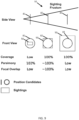
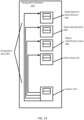
- the sign detection controller 121 is configured to select one or more association sets whose positioned sightings cover as much of the position candidate as possible, and which also do it parsimoniously, in the sense that they are not much bigger than required.
- the sign detection controller 121 is configured to identify the association sets as multiple locations for sign detection in response to the comparison of the sighting frustum to the sign position candidate having at least one point neighborhood classified as planar.
- the sign detection controller 121 may calculate an intersection of the at least one point neighborhood and the sighting frustum. The intersection is an area of overlap for the point neighborhood and the sighting frustum.
- the intersection of the at least one point neighborhood (position candidate) and the sighting frustum may be an input to calculate a coverage value for the intersection of the at least one point neighborhood and the sighting frustum.
- the coverage value (CV) is calculated based on an area of the intersection A ( S ⁇ C ) of the at least one point neighborhood and the sighting frustum and the area of the at least one point neighborhood A(C) according to Equation 5.
- CV A S ⁇ C A C
- the sign detection controller 121 may be configured to calculate a focal overlap value as a minimum value between the coverage value and the parsimony value.
- the focal overlap value may be the output of a minimum value function that takes the coverage value and the parsimony value as inputs. In other words, the sign detection controller 121 selects the smaller value between the coverage value and the parsimony value.
- the coverage value and the parsimony values are fractional values, or decimal values between 0 and 1
- the focal overlap value is also a fractional value or a decimal value between 0 and 1.
- the focal overlap value may be referred to as a focus value for the intersection of the at least one point neighborhood (position candidate) and the sighting frustum.
- the sign detection controller 121 may be configured to select one or more association sets according to the focal overlap value.
- the sign detection controller 121 may identify multiple association sets when there are multiple planar regions in the point cloud data 31 that match the frustum 50 from the image data 33 and calculate a focal overlap value for the multiple association sets.
- the sign detection controller 121 is configured to rank the multiple focal overlap values according an ascending order.
- the sign detection controller 121 may sort the focal overlap values and store them in order in memory.
- the sign detection controller 121 may then select the highest focal overlap value from the ranked multiple focal overlap values.
- the sign detection controller 121 may also treat association sets that are not selected differently. For example, the sign detection controller 121 may flag or remove association sets that are not selected as the highest focal overlap value.
- the sign detection controller 121 may evaluate the association sets for object lifetime or information sufficiency.
- Example measures of object lifetime may include maturity and staleness.
- signs may be included in images at a first distance (e.g., more than 100m) away from the camera in front of the scanning vehicle 124, particularly for large highway signs.
- data e.g., LIDAR
- a second distance e.g., a range of less than 50m
- the sign detection controller 121 may not match sightings with position candidates until a substantial delay after the images are collected, and the sign detection controller 121 cannot calculate sighting frustum and position-candidate intersections until it can be assumed have scanned all the points on the sign plate have been scanned.
- the sign detection controller 121 calculates the maturity value and/or the staleness value in order to manage these issues.
- the sign detection controller 121 is configured to calculate the staleness value based on a distance traveled by the image sensor 102, for example, by movement of the mobile device 122 or the vehicle 124.
- a distance traveled by the image sensor 102 for example, by movement of the mobile device 122 or the vehicle 124.
- This sighting frustum 50 will, eventually, intersect with the sign's position candidate when the image sensor 102 is closer.
- the sighting frustum 50 may also intersect with occlusions (e.g. the back of a truck).
- the sign detection controller 121 may determine whether a time delay has passed, which is defined as a staleness value.
- the sign detection controller 121 may determine whether the mobile device 122 or vehicle 124 has traveled a threshold distance. In one example, sightings are stale at a first distance value (e.g., 250m) past the point where the image data 33 was captured, and that position candidates are stale at a second distance value (e.g., 50m) past the point where point cloud data 31 was last collected. If all the sightings and the position candidate in an association-set are stale, the sign detection controller 121 determines that the association set is stale. Once an association set is stale, there is nothing in the future can change the determinations of the sign detection controller 121 for the ranking of the association set as a potential sign location.
- Figure 10 illustrates an example vehicles 124 that include a sensor array for data collection.
- One of the vehicles 124 may be a collection vehicle configured to collect data in the area proximate to the vehicle 124.
- the collection vehicle may include one or more distance data collection device or sensor, such as a light detection and ranging (LiDAR) device.
- the distance data collection sensor may generate point cloud data.
- the distance data collection sensor may include a laser range finder that rotates a mirror directing a laser to the surroundings or vicinity of the collection vehicle on a roadway or another collection device on any type of pathway. Other types of pathways may be substituted for the roadway in any embodiment described herein.
- the vehicles 124 may include a global positioning system, a dead reckoning-type system, cellular location system, or combinations of these or other systems, which may be referred to as position circuitry or a position detector.
- the positioning circuitry may include suitable sensing devices that measure the traveling distance, speed, direction, and so on, of the vehicle 124.
- the positioning system may also include a receiver and correlation chip to obtain a GPS signal.
- the one or more detectors or sensors may include an accelerometer built or embedded into or within the interior of the vehicle 124.
- a highly assisted driving (HAD) vehicle may refer to a vehicle that does not completely replace the human operator. Instead, in a highly assisted driving mode, the vehicle may perform some driving functions and the human operator may perform some driving functions. Vehicles may also be driven in a manual mode in which the human operator exercises a degree of control over the movement of the vehicle. The vehicles may also include a completely driverless mode. Other levels of automation are possible.
- the HAD vehicle may control the vehicle through steering or braking in response to the on the position of the vehicle, and may respond to geographic data received from geographic database 123 and the server 125 and sign detection identification and classification data received from the sign detection controller 121.
- ADAS vehicles include one or more partially automated systems in which the vehicle alerts the driver.
- the features are designed to avoid collisions automatically.
- Features may include adaptive cruise control, automate braking, or steering adjustments to keep the driver in the correct lane.
- ADAS vehicles may issue warnings for the driver based on the position of the vehicle or based on to geographic data received from geographic database 123 and the server 125 and sign detection identification and classification data received from the sign detection controller 121.
- Level 0 Automated system issues warnings and may momentarily intervene but has no sustained vehicle control.
- Level 1 (“hands on”): The driver and the automated system share control of the vehicle. Examples are Adaptive Cruise Control (ACC), where the driver controls steering and the automated system controls speed; and Parking Assistance, where steering is automated while speed is manual. The driver must be ready to retake full control at any time. Lane Keeping Assistance (LKA) Type II is a further example of level 1 self-driving.
- Level 2 (“hands off”): The automated system takes full control of the vehicle (accelerating, braking, and steering). The driver must monitor the driving and be prepared to intervene immediately at any time if the automated system fails to respond properly.
- the shorthand "hands off” is not meant to be taken literally. In fact, contact between hand and wheel is often mandatory during SAE 2 driving, to confirm that the driver is ready to intervene.
- Level 3 (“eyes off"): The driver can safely turn their attention away from the driving tasks, e.g. the driver can text or watch a movie. The vehicle will handle situations that call for an immediate response, like emergency braking. The driver must still be prepared to intervene within some limited time, specified by the manufacturer, when called upon by the vehicle to do so.
- a traffic jam pilot when activated by the human driver, allows the car takes full control of all aspects of driving in slow-moving traffic at up to 60 kilometers per hour. The function works only on highways with a physical barrier separating one stream of traffic from oncoming traffic.
- the processor 200 or the processor 300 calculates an object lifetime value for the plurality of association sets.
- the object lifetime value may be a numerical value that represents the distance traveled since the data for the frustum or the sign candidate were first collected by the sensor array 206. When the distance reaches a threshold distance, the object lifetime value is a predetermined value.
- the processor is a specialized processor or includes a module as means for calculating an object lifetime value for the plurality of association sets.
- the geometric features may include curvature, slope, or other features.
- the curvature of a road segment describes a radius of a circle that in part would have the same path as the road segment.
- the slope of a road segment describes the difference between the starting elevation and ending elevation of the road segment.
- the slope of the road segment may be described as the rise over the run or as an angle.
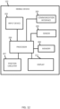
- the communication interface 205 and/or communication interface 305 may include any operable connection.
- An operable connection may be one in which signals, physical communications, and/or logical communications may be sent and/or received.
- An operable connection may include a physical interface, an electrical interface, and/or a data interface.
- the communication interface 205 and/or communication interface 305 provides for wireless and/or wired communications in any now known or later developed format.
- the databases 123 may include geographic data used for traffic and/or navigation-related applications.
- the geographic data may include data representing a road network or system including road segment data and node data.
- the road segment data represent roads, and the node data represent the ends or intersections of the roads.
- the road segment data and the node data indicate the location of the roads and intersections as well as various attributes of the roads and intersections. Other formats than road segments and nodes may be used for the geographic data.
- the geographic data may include structured cartographic data or pedestrian routes.
- the databases may also include other attributes of or about the roads such as, for example, geographic coordinates, street names, address ranges, speed limits, turn restrictions at intersections, and/or other navigation related attributes (e.g., one or more of the road segments is part of a highway or toll way, the location of stop signs and/or stoplights along the road segments), as well as points of interest (POIs), such as gasoline stations, hotels, restaurants, museums, stadiums, offices, automobile dealerships, auto repair shops, buildings, stores, parks, etc.
- POIs points of interest
- the databases may also contain one or more node data record(s) which may be associated with attributes (e.g., about the intersections) such as, for example, geographic coordinates, street names, address ranges, speed limits, turn restrictions at intersections, and other navigation related attributes, as well as POIs such as, for example, gasoline stations, hotels, restaurants, museums, stadiums, offices, automobile dealerships, auto repair shops, buildings, stores, parks, etc.
- attributes e.g., about the intersections
- POIs such as, for example, gasoline stations, hotels, restaurants, museums, stadiums, offices, automobile dealerships, auto repair shops, buildings, stores, parks, etc.
- the geographic data may additionally or alternatively include other data records such as, for example, POI data records, topographical data records, cartographic data records, routing data, and maneuver data.
- the databases may include historical traffic speed data for one or more road segments.
- the databases may also include traffic attributes for one or more road segments.
- a traffic attribute may indicate that a road segment has a high probability of traffic congestion.
- the positioning circuitry 207 may include a Global Positioning System (GPS), Global Navigation Satellite System (GLONASS), or a cellular or similar position sensor for providing location data.
- GPS Global Positioning System
- GLONASS Global Navigation Satellite System
- the positioning system may utilize GPS-type technology, a dead reckoning-type system, cellular location, or combinations of these or other systems.
- the positioning circuitry 207 may include suitable sensing devices that measure the traveling distance, speed, direction, and so on, of the mobile device 122.
- the positioning system may also include a receiver and correlation chip to obtain a GPS signal.
- the mobile device 122 receives location data from the positioning system.
- the location data indicates the location of the mobile device 122.
- the methods described herein may be implemented by software programs executable by a computer system.
- implementations can include distributed processing, component/object distributed processing, and parallel processing.
- virtual computer system processing can be constructed to implement one or more of the methods or functionality as described herein.
- the processes and logic flows described in this specification can be performed by one or more programmable processors executing one or more computer programs to perform functions by operating on input data and generating output.
- the processes and logic flows can also be performed by, and apparatus can also be implemented as, special purpose logic circuitry, e.g., an FPGA (field programmable gate array) or an ASIC (application specific integrated circuit).
- the term 'circuitry' or 'circuit' refers to all of the following: (a)hardware-only circuit implementations (such as implementations in only analog and/or digital circuitry) and (b) to combinations of circuits and software (and/or firmware), such as (as applicable): (i) to a combination of processor(s) or (ii) to portions of processor(s)/software (including digital signal processor(s)), software, and memory(ies) that work together to cause an apparatus, such as a mobile phone or server, to perform various functions) and (c) to circuits, such as a microprocessor(s) or a portion of a microprocessor(s), that require software or firmware for operation, even if the software or firmware is not physically present.
- circuitry would also cover an implementation of merely a processor (or multiple processors) or portion of a processor and its (or their) accompanying software and/or firmware.
- circuitry would also cover, for example and if applicable to the particular claim element, a baseband integrated circuit or applications processor integrated circuit for a mobile phone or a similar integrated circuit in server, a cellular network device, or other network device.
- processors suitable for the execution of a computer program include, by way of example, both general and special purpose microprocessors, and anyone or more processors of any kind of digital computer.
- a processor receives instructions and data from a read only memory or a random access memory or both.
- the essential elements of a computer are a processor for performing instructions and one or more memory devices for storing instructions and data.
- a computer also includes, or be operatively coupled to receive data from or transfer data to, or both, one or more mass storage devices for storing data, e.g., magnetic, magneto optical disks, or optical disks.
- mass storage devices for storing data, e.g., magnetic, magneto optical disks, or optical disks.
- a computer need not have such devices.
- a computer can be embedded in another device, e.g., a mobile telephone, a personal digital assistant (PDA), a mobile audio player, a Global Positioning System (GPS) receiver, to name just a few.
- Computer readable media suitable for storing computer program instructions and data include all forms of non-volatile memory, media and memory devices, including by way of example semiconductor memory devices, e.g., EPROM, EEPROM, and flash memory devices; magnetic disks, e.g., internal hard disks or removable disks; magneto optical disks; and CD ROM and DVD-ROM disks.
- the processor and the memory can be supplemented by, or incorporated in, special purpose logic circuitry.
- a vehicle may be considered a mobile device, or the mobile device may be integrated into a vehicle.
- embodiments of the subject matter described in this specification can be implemented on a device having a display, e.g., a CRT (cathode ray tube) or LCD (liquid crystal display) monitor, for displaying information to the user and a keyboard and a pointing device, e.g., a mouse or a trackball, by which the user can provide input to the computer.
- a display e.g., a CRT (cathode ray tube) or LCD (liquid crystal display) monitor
- a keyboard and a pointing device e.g., a mouse or a trackball
- Other kinds of devices can be used to provide for interaction with a user as well; for example, feedback provided to the user can be any form of sensory feedback, e.g., visual feedback, auditory feedback, or tactile feedback; and input from the user can be received in any form, including acoustic, speech, or tactile input.
- computer-readable medium includes a single medium or multiple media, such as a centralized or distributed database, and/or associated caches and servers that store one or more sets of instructions.
- computer-readable medium shall also include any medium that is capable of storing, encoding or carrying a set of instructions for execution by a processor or that cause a computer system to perform any one or more of the methods or operations disclosed herein.
- the computer-readable medium can include a solid-state memory such as a memory card or other package that houses one or more non-volatile read-only memories. Further, the computer-readable medium can be a random access memory or other volatile re-writable memory. Additionally, the computer-readable medium can include a magneto-optical or optical medium, such as a disk or tapes or other storage device to capture carrier wave signals such as a signal communicated over a transmission medium. A digital file attachment to an e-mail or other self-contained information archive or set of archives may be considered a distribution medium that is a tangible storage medium.
- the disclosure is considered to include any one or more of a computer-readable medium or a distribution medium and other equivalents and successor media, in which data or instructions may be stored. These examples may be collectively referred to as a non-transitory computer readable medium.
- dedicated hardware implementations such as application specific integrated circuits, programmable logic arrays and other hardware devices, can be constructed to implement one or more of the methods described herein.
- Applications that may include the apparatus and systems of various embodiments can broadly include a variety of electronic and computer systems.
- One or more embodiments described herein may implement functions using two or more specific interconnected hardware modules or devices with related control and data signals that can be communicated between and through the modules, or as portions of an application-specific integrated circuit.
- Embodiments of the subject matter described in this specification can be implemented in a computing system that includes a back end component, e.g., as a data server, or that includes a middleware component, e.g., an application server, or that includes a front end component, e.g., a client computer having a graphical user interface or a Web browser through which a user can interact with an implementation of the subject matter described in this specification, or any combination of one or more such back end, middleware, or front end components.
- the components of the system can be interconnected by any form or medium of digital data communication, e.g., a communication network. Examples of communication networks include a local area network (“LAN”) and a wide area network (“WAN”), e.g., the Internet.
- LAN local area network
- WAN wide area network
- the computing system can include clients and servers.
- a client and server are generally remote from each other and typically interact through a communication network.
- the relationship of client and server arises by virtue of computer programs running on the respective computers and having a client-server relationship to each other.
Landscapes
- Engineering & Computer Science (AREA)
- Physics & Mathematics (AREA)
- General Physics & Mathematics (AREA)
- Theoretical Computer Science (AREA)
- Computer Vision & Pattern Recognition (AREA)
- Multimedia (AREA)
- Computer Networks & Wireless Communication (AREA)
- Radar, Positioning & Navigation (AREA)
- Remote Sensing (AREA)
- Evolutionary Computation (AREA)
- Artificial Intelligence (AREA)
- Electromagnetism (AREA)
- Computing Systems (AREA)
- Databases & Information Systems (AREA)
- General Health & Medical Sciences (AREA)
- Medical Informatics (AREA)
- Software Systems (AREA)
- Health & Medical Sciences (AREA)
- Data Mining & Analysis (AREA)
- Life Sciences & Earth Sciences (AREA)
- Bioinformatics & Cheminformatics (AREA)
- Bioinformatics & Computational Biology (AREA)
- Evolutionary Biology (AREA)
- General Engineering & Computer Science (AREA)
- Traffic Control Systems (AREA)
- Image Analysis (AREA)
Claims (9)
- Procédé de détection de panneau de signalisation dans un nuage de points tridimensionnel et une image bidimensionnelle, le procédé comprenant en outre :la réception (S101) de données de nuage de points associées à une région géographique ;la classification d'au moins un voisinage de points dans les données de nuage de points en tant que linéaire, planaire ou volumétrique ;la sélection d'au moins un nuage de points classifié en tant que planaire comme candidat de position de panneau de signalisation ;la réception (S103) de données d'image (33) associées à la région géographique ;l'analyse de régions à l'intérieur des données d'image pour identifier au moins un panneau de signalisation (42) ; etla fourniture (S115) d'un emplacement pour la détection de panneau de signalisation ;caractérisé en ce que le procédé comprend en outrele calcul d'un cône d'observation (50) à partir des données d'image, le cône d'observation représentant des points possibles dans un espace 3D qui pourraient être associés à l'au moins un panneau de signalisation, dans lequel le cône d'observation est calculé sur la base d'un emplacement d'un capteur d'image (102) ayant collecté les données d'image associées à la région géographique ; etla réalisation d'une comparaison (S105) du cône d'observation au candidat de position de panneau de signalisation ayant au moins un voisinage de points classifié en tant que planaire ; dans lequel l'emplacement pour la détection de panneau de signalisation est fourni en réponse à la comparaison.
- Procédé selon la revendication 1, comprenant en outre :
l'identification d'une pluralité d'emplacements de détection de panneau de signalisation en réponse à la comparaison. - Procédé selon la revendication 2, comprenant en outre :
le calcul d'une intersection de l'au moins un voisinage de points classifié en tant que planaire et du cône d'observation. - Procédé selon la revendication 3, comprenant en outre :
le calcul d'une valeur de couverture pour l'intersection de l'au moins un voisinage de points et du cône d'observation, dans lequel la valeur de couverture, CV, est calculée sur la base d'une aire d'une intersection A(S ∩ C) de l'au moins un voisinage de points et du cône d'observation et de l'aire de l'au moins un voisinage de points A(C) selon
- Procédé selon la revendication 3 ou la revendication 4, comprenant en outre :
le calcul d'une valeur de parcimonie pour l'intersection de l'au moins un voisinage de points et du cône d'observation, dans lequel la valeur de parcimonie, PV, est calculée sur la base d'une aire d'une intersection A(S ∩ C) de l'au moins un voisinage de points classifié en tant que planaire et du cône d'observation et de l'aire du cône d'observation A(S) dans un plan de l'intersection de l'au moins un voisinage de points et du cône d'observation selon
- Procédé selon la revendication 5 lorsqu'elle dépend de la revendication 4, comprenant en outre :
la détermination (S107) d'une valeur de chevauchement focal en tant qu'une valeur minimale entre la valeur de couverture et la valeur de parcimonie. - Procédé selon la revendication 6, dans lequel de multiples valeurs de chevauchement focal sont déterminées entre une pluralité de voisinages de points et le cône d'observation, le procédé comprenant en outre :le classement (S109) des multiples valeurs de chevauchement focal par ordre croissant ; etla sélection d'une valeur de chevauchement focal la plus élevée parmi les multiples valeurs de chevauchement focal classées.
- Appareil (122, 125) de détection de panneau de signalisation dans un nuage de points tridimensionnel et une image bidimensionnelle, l'appareil comprenant des moyens pour réaliser les étapes selon l'une quelconque des revendications précédentes.
- Support non transitoire lisible par ordinateur incluant des instructions qui, lorsqu'elles sont exécutées par un processeur, amènent le processeur à réaliser le procédé selon l'une quelconque des revendications 1 à 7.
Applications Claiming Priority (1)
| Application Number | Priority Date | Filing Date | Title |
|---|---|---|---|
| US16/223,679 US11055546B2 (en) | 2018-12-18 | 2018-12-18 | Automatic positioning of 2D image sign sightings in 3D space |
Publications (2)
| Publication Number | Publication Date |
|---|---|
| EP3671547A1 EP3671547A1 (fr) | 2020-06-24 |
| EP3671547B1 true EP3671547B1 (fr) | 2024-07-10 |
Family
ID=68944542
Family Applications (1)
| Application Number | Title | Priority Date | Filing Date |
|---|---|---|---|
| EP19217361.5A Active EP3671547B1 (fr) | 2018-12-18 | 2019-12-18 | Positionnement automatique en 3d des panneaux routiers détectés en images 2d |
Country Status (2)
| Country | Link |
|---|---|
| US (2) | US11055546B2 (fr) |
| EP (1) | EP3671547B1 (fr) |
Families Citing this family (16)
| Publication number | Priority date | Publication date | Assignee | Title |
|---|---|---|---|---|
| US11055546B2 (en) * | 2018-12-18 | 2021-07-06 | Here Global B.V. | Automatic positioning of 2D image sign sightings in 3D space |
| US11250697B2 (en) * | 2018-12-26 | 2022-02-15 | Uatc, Llc | Missing traffic face detector |
| US11520331B2 (en) * | 2018-12-28 | 2022-12-06 | Intel Corporation | Methods and apparatus to update autonomous vehicle perspectives |
| US20210004613A1 (en) | 2019-07-02 | 2021-01-07 | DeepMap Inc. | Annotating high definition map data with semantic labels |
| JP7468002B2 (ja) * | 2020-03-10 | 2024-04-16 | 日本電気株式会社 | 異常箇所表示装置、異常箇所表示システム、異常箇所表示方法、及び異常箇所表示プログラム |
| CN112069899A (zh) * | 2020-08-05 | 2020-12-11 | 深兰科技(上海)有限公司 | 一种路肩检测方法、装置及存储介质 |
| KR102876218B1 (ko) | 2021-11-30 | 2025-10-28 | 한국전자통신연구원 | 온실환경에서 이동로봇의 자율주행을 위한 레일 탐지 장치 및 방법 |
| CN115205174A (zh) * | 2022-06-06 | 2022-10-18 | 阿里巴巴(中国)有限公司 | 图像处理方法、装置及计算机可读存储介质 |
| CN115170648B (zh) * | 2022-06-29 | 2023-04-07 | 广西柳工机械股份有限公司 | 一种车厢位姿确定方法及装置 |
| CN117710406A (zh) * | 2022-09-06 | 2024-03-15 | 北京图森智途科技有限公司 | 用于为对象建模的方法、设备、存储介质及车辆控制方法 |
| EP4350579A1 (fr) * | 2022-10-06 | 2024-04-10 | Volkswagen Ag | Architecture de réseau pour une détection d'objet tridimensionnel dans un nuage de points, procédé et véhicule |
| US12397799B2 (en) * | 2022-10-27 | 2025-08-26 | Nec Corporation Of America | Object based vehicle localization |
| CN115620264B (zh) * | 2022-12-02 | 2023-03-07 | 广汽埃安新能源汽车股份有限公司 | 车辆定位方法、装置、电子设备和计算机可读介质 |
| JP7739345B2 (ja) * | 2023-01-30 | 2025-09-16 | 株式会社東芝 | プログラム、情報処理装置および情報処理方法 |
| EP4685334A1 (fr) | 2023-03-20 | 2026-01-28 | Enaex Servicios S.A. | Procédé et système automatisé pour le balayage, la détection et la révision de perforations dans un front rocheux |
| CN118691628B (zh) * | 2024-06-24 | 2025-11-25 | 浙江大学 | 对单个复杂构件的测量点云进行几何要素分割的方法 |
Family Cites Families (8)
| Publication number | Priority date | Publication date | Assignee | Title |
|---|---|---|---|---|
| US8798926B2 (en) | 2012-11-14 | 2014-08-05 | Navteq B.V. | Automatic image capture |
| GB2520338A (en) | 2013-11-19 | 2015-05-20 | Nokia Corp | Automatic scene parsing |
| DE102016208025B4 (de) * | 2016-05-10 | 2019-06-27 | Continental Automotive Gmbh | Verfahren zur Erfassung von Verkehrszeichen |
| CN107818288B (zh) * | 2016-09-13 | 2019-04-09 | 腾讯科技(深圳)有限公司 | 标志牌信息获取方法及装置 |
| US10859395B2 (en) | 2016-12-30 | 2020-12-08 | DeepMap Inc. | Lane line creation for high definition maps for autonomous vehicles |
| US11163998B2 (en) * | 2018-10-22 | 2021-11-02 | Woven Planet North America, Inc. | Systems and methods for automated image labeling for images captured from vehicles |
| US10846817B2 (en) * | 2018-11-15 | 2020-11-24 | Toyota Research Institute, Inc. | Systems and methods for registering 3D data with 2D image data |
| US11055546B2 (en) * | 2018-12-18 | 2021-07-06 | Here Global B.V. | Automatic positioning of 2D image sign sightings in 3D space |
-
2018
- 2018-12-18 US US16/223,679 patent/US11055546B2/en active Active
-
2019
- 2019-12-18 EP EP19217361.5A patent/EP3671547B1/fr active Active
-
2021
- 2021-06-10 US US17/344,297 patent/US11867819B2/en active Active
Also Published As
| Publication number | Publication date |
|---|---|
| US20210303884A1 (en) | 2021-09-30 |
| EP3671547A1 (fr) | 2020-06-24 |
| US11867819B2 (en) | 2024-01-09 |
| US20200193195A1 (en) | 2020-06-18 |
| US11055546B2 (en) | 2021-07-06 |
Similar Documents
| Publication | Publication Date | Title |
|---|---|---|
| US11867819B2 (en) | Automatic positioning of 2D image sign sightings in 3D space | |
| US11423677B2 (en) | Automatic detection and positioning of pole-like objects in 3D | |
| US11645839B2 (en) | Lane feature detection in aerial images based on road geometry | |
| EP3673407B1 (fr) | Détection de dissimulation automatique dans des données de réseau routier | |
| US11657072B2 (en) | Automatic feature extraction from imagery | |
| US10970542B2 (en) | Scalable three dimensional object segmentation | |
| EP3714394B1 (fr) | Générateur de géométrie de localisation automatique pour des objets en forme de bande | |
| US10628671B2 (en) | Road modeling from overhead imagery | |
| US11782129B2 (en) | Automatic detection of overhead obstructions | |
| EP3244165B1 (fr) | Boucle de rétroaction basée sur une carte pour demander des observations supplémentaires à un véhicule | |
| US11237007B2 (en) | Dangerous lane strands | |
| US20220277163A1 (en) | Predictive shadows to suppress false positive lane marking detection | |
| US11670090B2 (en) | Automatic detection and positioning of structure faces | |
| US11557132B2 (en) | Lane marking |
Legal Events
| Date | Code | Title | Description |
|---|---|---|---|
| PUAI | Public reference made under article 153(3) epc to a published international application that has entered the european phase |
Free format text: ORIGINAL CODE: 0009012 |
|
| STAA | Information on the status of an ep patent application or granted ep patent |
Free format text: STATUS: THE APPLICATION HAS BEEN PUBLISHED |
|
| AK | Designated contracting states |
Kind code of ref document: A1 Designated state(s): AL AT BE BG CH CY CZ DE DK EE ES FI FR GB GR HR HU IE IS IT LI LT LU LV MC MK MT NL NO PL PT RO RS SE SI SK SM TR |
|
| AX | Request for extension of the european patent |
Extension state: BA ME |
|
| STAA | Information on the status of an ep patent application or granted ep patent |
Free format text: STATUS: REQUEST FOR EXAMINATION WAS MADE |
|
| 17P | Request for examination filed |
Effective date: 20201216 |
|
| RBV | Designated contracting states (corrected) |
Designated state(s): AL AT BE BG CH CY CZ DE DK EE ES FI FR GB GR HR HU IE IS IT LI LT LU LV MC MK MT NL NO PL PT RO RS SE SI SK SM TR |
|
| STAA | Information on the status of an ep patent application or granted ep patent |
Free format text: STATUS: EXAMINATION IS IN PROGRESS |
|
| 17Q | First examination report despatched |
Effective date: 20220314 |
|
| P01 | Opt-out of the competence of the unified patent court (upc) registered |
Effective date: 20230522 |
|
| REG | Reference to a national code |
Ref country code: DE Ref legal event code: R079 Free format text: PREVIOUS MAIN CLASS: G06K0009000000 Ipc: G06V0010800000 Ref document number: 602019054915 Country of ref document: DE |
|
| GRAP | Despatch of communication of intention to grant a patent |
Free format text: ORIGINAL CODE: EPIDOSNIGR1 |
|
| STAA | Information on the status of an ep patent application or granted ep patent |
Free format text: STATUS: GRANT OF PATENT IS INTENDED |
|
| RIC1 | Information provided on ipc code assigned before grant |
Ipc: G06F 18/25 20230101ALI20230906BHEP Ipc: G01S 7/48 20060101ALI20230906BHEP Ipc: G01S 17/931 20200101ALI20230906BHEP Ipc: G01S 17/89 20200101ALI20230906BHEP Ipc: G06V 20/58 20220101ALI20230906BHEP Ipc: G06V 10/80 20220101AFI20230906BHEP |
|
| INTG | Intention to grant announced |
Effective date: 20230925 |
|
| RAP3 | Party data changed (applicant data changed or rights of an application transferred) |
Owner name: HERE GLOBAL B.V. |
|
| GRAJ | Information related to disapproval of communication of intention to grant by the applicant or resumption of examination proceedings by the epo deleted |
Free format text: ORIGINAL CODE: EPIDOSDIGR1 |
|
| STAA | Information on the status of an ep patent application or granted ep patent |
Free format text: STATUS: EXAMINATION IS IN PROGRESS |
|
| GRAP | Despatch of communication of intention to grant a patent |
Free format text: ORIGINAL CODE: EPIDOSNIGR1 |
|
| STAA | Information on the status of an ep patent application or granted ep patent |
Free format text: STATUS: GRANT OF PATENT IS INTENDED |
|
| INTC | Intention to grant announced (deleted) | ||
| INTG | Intention to grant announced |
Effective date: 20240205 |
|
| GRAS | Grant fee paid |
Free format text: ORIGINAL CODE: EPIDOSNIGR3 |
|
| GRAA | (expected) grant |
Free format text: ORIGINAL CODE: 0009210 |
|
| STAA | Information on the status of an ep patent application or granted ep patent |
Free format text: STATUS: THE PATENT HAS BEEN GRANTED |
|
| AK | Designated contracting states |
Kind code of ref document: B1 Designated state(s): AL AT BE BG CH CY CZ DE DK EE ES FI FR GB GR HR HU IE IS IT LI LT LU LV MC MK MT NL NO PL PT RO RS SE SI SK SM TR |
|
| REG | Reference to a national code |
Ref country code: CH Ref legal event code: EP |
|
| REG | Reference to a national code |
Ref country code: DE Ref legal event code: R096 Ref document number: 602019054915 Country of ref document: DE |
|
| REG | Reference to a national code |
Ref country code: NL Ref legal event code: FP |
|
| REG | Reference to a national code |
Ref country code: LT Ref legal event code: MG9D |
|
| PG25 | Lapsed in a contracting state [announced via postgrant information from national office to epo] |
Ref country code: PT Free format text: LAPSE BECAUSE OF FAILURE TO SUBMIT A TRANSLATION OF THE DESCRIPTION OR TO PAY THE FEE WITHIN THE PRESCRIBED TIME-LIMIT Effective date: 20241111 |
|
| REG | Reference to a national code |
Ref country code: AT Ref legal event code: MK05 Ref document number: 1702727 Country of ref document: AT Kind code of ref document: T Effective date: 20240710 |
|
| PG25 | Lapsed in a contracting state [announced via postgrant information from national office to epo] |
Ref country code: PT Free format text: LAPSE BECAUSE OF FAILURE TO SUBMIT A TRANSLATION OF THE DESCRIPTION OR TO PAY THE FEE WITHIN THE PRESCRIBED TIME-LIMIT Effective date: 20241111 |
|
| PG25 | Lapsed in a contracting state [announced via postgrant information from national office to epo] |
Ref country code: NO Free format text: LAPSE BECAUSE OF FAILURE TO SUBMIT A TRANSLATION OF THE DESCRIPTION OR TO PAY THE FEE WITHIN THE PRESCRIBED TIME-LIMIT Effective date: 20241010 |
|
| PG25 | Lapsed in a contracting state [announced via postgrant information from national office to epo] |
Ref country code: FI Free format text: LAPSE BECAUSE OF FAILURE TO SUBMIT A TRANSLATION OF THE DESCRIPTION OR TO PAY THE FEE WITHIN THE PRESCRIBED TIME-LIMIT Effective date: 20240710 Ref country code: GR Free format text: LAPSE BECAUSE OF FAILURE TO SUBMIT A TRANSLATION OF THE DESCRIPTION OR TO PAY THE FEE WITHIN THE PRESCRIBED TIME-LIMIT Effective date: 20241011 Ref country code: PL Free format text: LAPSE BECAUSE OF FAILURE TO SUBMIT A TRANSLATION OF THE DESCRIPTION OR TO PAY THE FEE WITHIN THE PRESCRIBED TIME-LIMIT Effective date: 20240710 |
|
| PG25 | Lapsed in a contracting state [announced via postgrant information from national office to epo] |
Ref country code: BG Free format text: LAPSE BECAUSE OF FAILURE TO SUBMIT A TRANSLATION OF THE DESCRIPTION OR TO PAY THE FEE WITHIN THE PRESCRIBED TIME-LIMIT Effective date: 20240710 |
|
| PG25 | Lapsed in a contracting state [announced via postgrant information from national office to epo] |
Ref country code: LV Free format text: LAPSE BECAUSE OF FAILURE TO SUBMIT A TRANSLATION OF THE DESCRIPTION OR TO PAY THE FEE WITHIN THE PRESCRIBED TIME-LIMIT Effective date: 20240710 |
|
| PG25 | Lapsed in a contracting state [announced via postgrant information from national office to epo] |
Ref country code: IS Free format text: LAPSE BECAUSE OF FAILURE TO SUBMIT A TRANSLATION OF THE DESCRIPTION OR TO PAY THE FEE WITHIN THE PRESCRIBED TIME-LIMIT Effective date: 20241110 Ref country code: AT Free format text: LAPSE BECAUSE OF FAILURE TO SUBMIT A TRANSLATION OF THE DESCRIPTION OR TO PAY THE FEE WITHIN THE PRESCRIBED TIME-LIMIT Effective date: 20240710 |
|
| PG25 | Lapsed in a contracting state [announced via postgrant information from national office to epo] |
Ref country code: HR Free format text: LAPSE BECAUSE OF FAILURE TO SUBMIT A TRANSLATION OF THE DESCRIPTION OR TO PAY THE FEE WITHIN THE PRESCRIBED TIME-LIMIT Effective date: 20240710 |
|
| PG25 | Lapsed in a contracting state [announced via postgrant information from national office to epo] |
Ref country code: ES Free format text: LAPSE BECAUSE OF FAILURE TO SUBMIT A TRANSLATION OF THE DESCRIPTION OR TO PAY THE FEE WITHIN THE PRESCRIBED TIME-LIMIT Effective date: 20240710 Ref country code: RS Free format text: LAPSE BECAUSE OF FAILURE TO SUBMIT A TRANSLATION OF THE DESCRIPTION OR TO PAY THE FEE WITHIN THE PRESCRIBED TIME-LIMIT Effective date: 20241010 |
|
| PG25 | Lapsed in a contracting state [announced via postgrant information from national office to epo] |
Ref country code: RS Free format text: LAPSE BECAUSE OF FAILURE TO SUBMIT A TRANSLATION OF THE DESCRIPTION OR TO PAY THE FEE WITHIN THE PRESCRIBED TIME-LIMIT Effective date: 20241010 Ref country code: PL Free format text: LAPSE BECAUSE OF FAILURE TO SUBMIT A TRANSLATION OF THE DESCRIPTION OR TO PAY THE FEE WITHIN THE PRESCRIBED TIME-LIMIT Effective date: 20240710 Ref country code: NO Free format text: LAPSE BECAUSE OF FAILURE TO SUBMIT A TRANSLATION OF THE DESCRIPTION OR TO PAY THE FEE WITHIN THE PRESCRIBED TIME-LIMIT Effective date: 20241010 Ref country code: LV Free format text: LAPSE BECAUSE OF FAILURE TO SUBMIT A TRANSLATION OF THE DESCRIPTION OR TO PAY THE FEE WITHIN THE PRESCRIBED TIME-LIMIT Effective date: 20240710 Ref country code: IS Free format text: LAPSE BECAUSE OF FAILURE TO SUBMIT A TRANSLATION OF THE DESCRIPTION OR TO PAY THE FEE WITHIN THE PRESCRIBED TIME-LIMIT Effective date: 20241110 Ref country code: HR Free format text: LAPSE BECAUSE OF FAILURE TO SUBMIT A TRANSLATION OF THE DESCRIPTION OR TO PAY THE FEE WITHIN THE PRESCRIBED TIME-LIMIT Effective date: 20240710 Ref country code: GR Free format text: LAPSE BECAUSE OF FAILURE TO SUBMIT A TRANSLATION OF THE DESCRIPTION OR TO PAY THE FEE WITHIN THE PRESCRIBED TIME-LIMIT Effective date: 20241011 Ref country code: FI Free format text: LAPSE BECAUSE OF FAILURE TO SUBMIT A TRANSLATION OF THE DESCRIPTION OR TO PAY THE FEE WITHIN THE PRESCRIBED TIME-LIMIT Effective date: 20240710 Ref country code: ES Free format text: LAPSE BECAUSE OF FAILURE TO SUBMIT A TRANSLATION OF THE DESCRIPTION OR TO PAY THE FEE WITHIN THE PRESCRIBED TIME-LIMIT Effective date: 20240710 Ref country code: BG Free format text: LAPSE BECAUSE OF FAILURE TO SUBMIT A TRANSLATION OF THE DESCRIPTION OR TO PAY THE FEE WITHIN THE PRESCRIBED TIME-LIMIT Effective date: 20240710 Ref country code: AT Free format text: LAPSE BECAUSE OF FAILURE TO SUBMIT A TRANSLATION OF THE DESCRIPTION OR TO PAY THE FEE WITHIN THE PRESCRIBED TIME-LIMIT Effective date: 20240710 |
|
| REG | Reference to a national code |
Ref country code: DE Ref legal event code: R097 Ref document number: 602019054915 Country of ref document: DE |
|
| PG25 | Lapsed in a contracting state [announced via postgrant information from national office to epo] |
Ref country code: DK Free format text: LAPSE BECAUSE OF FAILURE TO SUBMIT A TRANSLATION OF THE DESCRIPTION OR TO PAY THE FEE WITHIN THE PRESCRIBED TIME-LIMIT Effective date: 20240710 Ref country code: RO Free format text: LAPSE BECAUSE OF FAILURE TO SUBMIT A TRANSLATION OF THE DESCRIPTION OR TO PAY THE FEE WITHIN THE PRESCRIBED TIME-LIMIT Effective date: 20240710 Ref country code: SM Free format text: LAPSE BECAUSE OF FAILURE TO SUBMIT A TRANSLATION OF THE DESCRIPTION OR TO PAY THE FEE WITHIN THE PRESCRIBED TIME-LIMIT Effective date: 20240710 |
|
| PG25 | Lapsed in a contracting state [announced via postgrant information from national office to epo] |
Ref country code: EE Free format text: LAPSE BECAUSE OF FAILURE TO SUBMIT A TRANSLATION OF THE DESCRIPTION OR TO PAY THE FEE WITHIN THE PRESCRIBED TIME-LIMIT Effective date: 20240710 |
|
| PG25 | Lapsed in a contracting state [announced via postgrant information from national office to epo] |
Ref country code: CZ Free format text: LAPSE BECAUSE OF FAILURE TO SUBMIT A TRANSLATION OF THE DESCRIPTION OR TO PAY THE FEE WITHIN THE PRESCRIBED TIME-LIMIT Effective date: 20240710 |
|
| PG25 | Lapsed in a contracting state [announced via postgrant information from national office to epo] |
Ref country code: SK Free format text: LAPSE BECAUSE OF FAILURE TO SUBMIT A TRANSLATION OF THE DESCRIPTION OR TO PAY THE FEE WITHIN THE PRESCRIBED TIME-LIMIT Effective date: 20240710 Ref country code: IT Free format text: LAPSE BECAUSE OF FAILURE TO SUBMIT A TRANSLATION OF THE DESCRIPTION OR TO PAY THE FEE WITHIN THE PRESCRIBED TIME-LIMIT Effective date: 20240710 |
|
| PLBE | No opposition filed within time limit |
Free format text: ORIGINAL CODE: 0009261 |
|
| STAA | Information on the status of an ep patent application or granted ep patent |
Free format text: STATUS: NO OPPOSITION FILED WITHIN TIME LIMIT |
|
| 26N | No opposition filed |
Effective date: 20250411 |
|
| PG25 | Lapsed in a contracting state [announced via postgrant information from national office to epo] |
Ref country code: MC Free format text: LAPSE BECAUSE OF FAILURE TO SUBMIT A TRANSLATION OF THE DESCRIPTION OR TO PAY THE FEE WITHIN THE PRESCRIBED TIME-LIMIT Effective date: 20240710 |
|
| REG | Reference to a national code |
Ref country code: CH Ref legal event code: PL |
|
| REG | Reference to a national code |
Ref country code: NL Ref legal event code: MM Effective date: 20250101 |
|
| PG25 | Lapsed in a contracting state [announced via postgrant information from national office to epo] |
Ref country code: LU Free format text: LAPSE BECAUSE OF NON-PAYMENT OF DUE FEES Effective date: 20241218 |
|
| GBPC | Gb: european patent ceased through non-payment of renewal fee |
Effective date: 20241218 |
|
| PG25 | Lapsed in a contracting state [announced via postgrant information from national office to epo] |
Ref country code: SE Free format text: LAPSE BECAUSE OF FAILURE TO SUBMIT A TRANSLATION OF THE DESCRIPTION OR TO PAY THE FEE WITHIN THE PRESCRIBED TIME-LIMIT Effective date: 20240710 |
|
| PG25 | Lapsed in a contracting state [announced via postgrant information from national office to epo] |
Ref country code: NL Free format text: LAPSE BECAUSE OF NON-PAYMENT OF DUE FEES Effective date: 20250101 |
|
| REG | Reference to a national code |
Ref country code: BE Ref legal event code: MM Effective date: 20241231 |
|
| PG25 | Lapsed in a contracting state [announced via postgrant information from national office to epo] |
Ref country code: GB Free format text: LAPSE BECAUSE OF NON-PAYMENT OF DUE FEES Effective date: 20241218 Ref country code: BE Free format text: LAPSE BECAUSE OF NON-PAYMENT OF DUE FEES Effective date: 20241231 |
|
| PG25 | Lapsed in a contracting state [announced via postgrant information from national office to epo] |
Ref country code: CH Free format text: LAPSE BECAUSE OF NON-PAYMENT OF DUE FEES Effective date: 20241231 |
|
| PG25 | Lapsed in a contracting state [announced via postgrant information from national office to epo] |
Ref country code: IE Free format text: LAPSE BECAUSE OF NON-PAYMENT OF DUE FEES Effective date: 20241218 |
|
| PGFP | Annual fee paid to national office [announced via postgrant information from national office to epo] |
Ref country code: DE Payment date: 20250930 Year of fee payment: 7 |
|
| PGFP | Annual fee paid to national office [announced via postgrant information from national office to epo] |
Ref country code: FR Payment date: 20251008 Year of fee payment: 7 |