EP3693703B1 - Système de détermination de la position - Google Patents
Système de détermination de la position Download PDFInfo
- Publication number
- EP3693703B1 EP3693703B1 EP20153392.4A EP20153392A EP3693703B1 EP 3693703 B1 EP3693703 B1 EP 3693703B1 EP 20153392 A EP20153392 A EP 20153392A EP 3693703 B1 EP3693703 B1 EP 3693703B1
- Authority
- EP
- European Patent Office
- Prior art keywords
- position determination
- environment
- map
- values
- determination system
- Prior art date
- Legal status (The legal status is an assumption and is not a legal conclusion. Google has not performed a legal analysis and makes no representation as to the accuracy of the status listed.)
- Active
Links
Images

Classifications
-
- G—PHYSICS
- G01—MEASURING; TESTING
- G01C—MEASURING DISTANCES, LEVELS OR BEARINGS; SURVEYING; NAVIGATION; GYROSCOPIC INSTRUMENTS; PHOTOGRAMMETRY OR VIDEOGRAMMETRY
- G01C21/00—Navigation; Navigational instruments not provided for in groups G01C1/00 - G01C19/00
- G01C21/38—Electronic maps specially adapted for navigation; Updating thereof
- G01C21/3804—Creation or updating of map data
- G01C21/3807—Creation or updating of map data characterised by the type of data
- G01C21/383—Indoor data
-
- G—PHYSICS
- G01—MEASURING; TESTING
- G01S—RADIO DIRECTION-FINDING; RADIO NAVIGATION; DETERMINING DISTANCE OR VELOCITY BY USE OF RADIO WAVES; LOCATING OR PRESENCE-DETECTING BY USE OF THE REFLECTION OR RERADIATION OF RADIO WAVES; ANALOGOUS ARRANGEMENTS USING OTHER WAVES
- G01S17/00—Systems using the reflection or reradiation of electromagnetic waves other than radio waves, e.g. lidar systems
- G01S17/02—Systems using the reflection of electromagnetic waves other than radio waves
- G01S17/06—Systems determining position data of a target
- G01S17/42—Simultaneous measurement of distance and other co-ordinates
-
- G—PHYSICS
- G01—MEASURING; TESTING
- G01C—MEASURING DISTANCES, LEVELS OR BEARINGS; SURVEYING; NAVIGATION; GYROSCOPIC INSTRUMENTS; PHOTOGRAMMETRY OR VIDEOGRAMMETRY
- G01C21/00—Navigation; Navigational instruments not provided for in groups G01C1/00 - G01C19/00
- G01C21/20—Instruments for performing navigational calculations
- G01C21/206—Instruments for performing navigational calculations specially adapted for indoor navigation
-
- G—PHYSICS
- G01—MEASURING; TESTING
- G01C—MEASURING DISTANCES, LEVELS OR BEARINGS; SURVEYING; NAVIGATION; GYROSCOPIC INSTRUMENTS; PHOTOGRAMMETRY OR VIDEOGRAMMETRY
- G01C21/00—Navigation; Navigational instruments not provided for in groups G01C1/00 - G01C19/00
- G01C21/26—Navigation; Navigational instruments not provided for in groups G01C1/00 - G01C19/00 specially adapted for navigation in a road network
- G01C21/28—Navigation; Navigational instruments not provided for in groups G01C1/00 - G01C19/00 specially adapted for navigation in a road network with correlation of data from several navigational instruments
- G01C21/30—Map- or contour-matching
-
- G—PHYSICS
- G01—MEASURING; TESTING
- G01C—MEASURING DISTANCES, LEVELS OR BEARINGS; SURVEYING; NAVIGATION; GYROSCOPIC INSTRUMENTS; PHOTOGRAMMETRY OR VIDEOGRAMMETRY
- G01C21/00—Navigation; Navigational instruments not provided for in groups G01C1/00 - G01C19/00
- G01C21/38—Electronic maps specially adapted for navigation; Updating thereof
- G01C21/3863—Structures of map data
- G01C21/387—Organisation of map data, e.g. version management or database structures
- G01C21/3881—Tile-based structures
-
- G—PHYSICS
- G01—MEASURING; TESTING
- G01S—RADIO DIRECTION-FINDING; RADIO NAVIGATION; DETERMINING DISTANCE OR VELOCITY BY USE OF RADIO WAVES; LOCATING OR PRESENCE-DETECTING BY USE OF THE REFLECTION OR RERADIATION OF RADIO WAVES; ANALOGOUS ARRANGEMENTS USING OTHER WAVES
- G01S17/00—Systems using the reflection or reradiation of electromagnetic waves other than radio waves, e.g. lidar systems
- G01S17/88—Lidar systems specially adapted for specific applications
- G01S17/89—Lidar systems specially adapted for specific applications for mapping or imaging
- G01S17/894—Three-dimensional [3D] imaging with simultaneous measurement of time-of-flight at a two-dimensional [2D] array of receiver pixels, e.g. time-of-flight cameras or flash lidar
-
- G—PHYSICS
- G06—COMPUTING OR CALCULATING; COUNTING
- G06V—IMAGE OR VIDEO RECOGNITION OR UNDERSTANDING
- G06V20/00—Scenes; Scene-specific elements
- G06V20/50—Context or environment of the image
- G06V20/56—Context or environment of the image exterior to a vehicle by using sensors mounted on the vehicle
Definitions
- the present invention relates to a position determination system for determining a position of a device that is mobile in an environment, an environmental sensor system for a device that is mobile in an environment, and a mobile device with an environmental sensor system.
- a device that can be moved in an environment can be a vehicle or an airplane, for example.
- Position determination systems for determining a position of such a device are generally designed to determine the position of the device by comparing measured values from an environment sensor of the device with an environment map. Such position determination systems are generally used to automatically control the mobile device through the environment and to carry out position or attitude control based on the determined position of the device.
- the accuracy and speed with which the position of the device can be determined largely determine the accuracy and speed that can be achieved when controlling the device.
- the map of the surroundings should be stored in a storage unit in a storage-efficient manner and at the same time it should be possible to read it out of the storage unit with short access times.
- the position can basically be determined in two dimensions and on the basis of a two-dimensional map of the area.
- two-dimensional maps of the environment can include a grid of map values that completely covers the environment, without the resource requirements required for storing and reading out the map values restricting the speed or accuracy of the position determination.
- a mobile device such as a vehicle
- a two-dimensional positioning system cannot easily be used in environments in which a three-dimensional position change of the device is possible.
- a comparison of the measured values of the environmental sensor obtained after the change in position with the merely two-dimensional map values no longer supplies any plausible results.
- Three-dimensional position changes occur in particular when driving on a ramp or when the device pitches or rolls, for example when driving over bumps in the ground.
- the movements in the individual planes are usually decoupled by moving the vehicle between the planes without determining the position, for example in an elevator.
- the maps of the individual levels used to determine the position can then be exchanged.
- an elevator only allows a lower throughput of vehicles.
- Pitching or rolling movements of a vehicle with a two-dimensional positioning system usually lead to an emergency stop of the vehicle being carried out due to the indeterminable position of the vehicle and operation of the vehicle only being resumed when the movements have subsided and the vehicle is again neutral has assumed position relative to the plane of movement. Such an emergency stop slows the vehicle and causes unwanted wear on the vehicle and the road surface.
- the pamphlet DE 10 2017 005 020 A1 describes a method for determining a position of a vehicle in a vehicle environment, in which a position of the vehicle within a lane of a roadway traveled by the vehicle is determined by means of a comparison between boundary coordinates of the lane and position data of the vehicle.
- the technical article: HELEN OLEYNIKOVA ET AL, "Signed Distance Fields: A Natural Representation for Both Mapping and Planning", RSS 2016 WORKSHOP: GEOMETRY AND BEYOND - REPRESENTATIONS, 1 January 2016 generally describes the use of signed distance fields to represent maps in robotics.
- Vito Cappellini ET AL “Image data compression by the discrete cosine transform", Mathematics and Computers in Simulation, pp. 599 - 608 , North-Holland, 1985 describes the application of the discrete cosine transformation in digital image processing.
- the object of the invention is to specify a position determination system for a mobile device, an environment sensor system for a mobile device, and a mobile device in such a way that a position of the device can be determined as quickly and precisely as possible.
- a position determination system for determining a position of a device that is mobile in an environment comprises a position determination unit and a memory unit.
- a map of the surroundings is stored in the storage unit.
- the position determination unit is set up to receive distance measurement values from an environment sensor of the mobile device and to determine the position of the mobile device by comparing the distance measurement values with the map of the environment.
- the stored environment map comprises at least one block, the block comprising an arrangement of map values representing the environment and the map values representing distance values to an edge of the environment.
- the block of the map of the surroundings is stored in the storage unit as coefficients of a combination, for example a linear combination, of basic functions, with the combination/linear combination of the basic functions approximating the map values of the block.
- the map of the surroundings can be stored in the memory unit in a memory-efficient manner if distance values from the edge of the surroundings are stored as map values and at the same time the map values are stored using the coefficients of the linear combination approximating the map values. This is because, as a rule, significantly fewer coefficients are required to approximate the card values than there are card values in the block.
- the surroundings can be subdivided into spatial elements, in particular into a regular arrangement of spatial elements, and the block can represent such a spatial element.
- the space elements can correspond to surface elements, for example rectangular, in particular square surface elements, and in a three-dimensional environment map, the space elements can correspond to volume elements, for example cuboid, in particular cubic volume elements.
- the map values representing the surroundings can in particular be arranged regularly in the block, for example on a grid, and represent spatial points of the spatial elements of the surroundings arranged regularly, for example in the form of a grid.
- the map values can be stored in particular as function values of a signed distance function ( SDF).
- SDF signed distance function
- the individual map values each indicate the shortest distance from the point in space represented by the map values to the edge of the environment (eg a wall).
- the map values have different signs, depending on whether the spatial points represented by the map values are arranged inside or outside the environment.
- the edge of the environment may comprise one or more self-contained edge sections. For example, such an edge section by an outer border of the area and another such border portion may comprise a surrounding recess located within the border, such as a recess located around a pillar or shelf of a production hall.
- the environment can be formed by a driving area of the vehicle or can include a driving area of the vehicle.
- the driving area can, for example, be a hall, in particular a production hall or warehouse.
- the vehicle may be configured to move three-dimensionally in the environment.
- the environment can include an inclined section that can be driven over by the vehicle, such as a ramp.
- the environment can also include several levels that are arranged one above the other and can be driven on by the vehicle.
- the map of the surroundings can include other blocks of this type.
- the blocks can be arranged next to each other and fill the environment.
- the blocks can in particular be arranged regularly next to one another and each comprise an arrangement, in particular a regular arrangement, of map values of the spatial elements of the environment represented by the blocks.
- the map values of all blocks of the map of the surroundings can be stored in the memory unit.
- the map values of the individual blocks are then stored in each case in that coefficients of that linear combination of the basic functions which approximates the map values of the relevant block are stored for the individual blocks.
- the map values approximated by the linear combination of the basis functions of the block form a multidimensional field of map values, in particular they can form a two-dimensional or a three-dimensional field of map values.
- the basis functions can, for example, be multi-dimensional, in particular two-dimensional or three-dimensional, polynomials, basis functions a multi-dimensional, in particular two-dimensional or three-dimensional, discrete cosine transformation (discrete cosine transformation, DCT) or basis functions of another suitable multi-dimensional, in particular two-dimensional or three-dimensional transformation.
- the linear combinations with which the card values of the individual blocks are approximated can each contain a number of basis functions which corresponds to a total number of the card values of the individual blocks.
- the individual blocks can, for example, comprise map values arranged in the form of a grid, with the blocks each comprising 16 map values in all three spatial directions. In total, the individual blocks then each contain 16 3 card values.
- the map values of the individual blocks can then be approximated by linear combinations of 16 3 basis functions, so that a maximum of 16 3 coefficients of the linear combination are to be stored in the memory unit for each block.
- the memory space required to store the blocks of the map of the surroundings can also be reduced by not storing all the coefficients of the individual linear combinations, but only those coefficients whose amplitude or Energy values each exceed a predetermined threshold. Such coefficients can also be referred to as dominant coefficients of the linear combination. In particular, only a maximum of 3, 9 or 27 coefficients can be stored per block.
- the environmental sensor can be in the form of a distance sensor (eg laser scanner) and can record the distance values, for example using the transit time principle. To detect the distance values, the environmental sensor can emit electromagnetic radiation or ultrasound, for example.
- the environment sensor can also be designed as a camera, in particular as a TOF camera (time-of-flight camera).
- the position determination unit can be designed to determine not only the position of the mobile device but also an orientation of the mobile device in space, ie overall a position of the mobile device, by comparing the measured distance values with the map of the surroundings.
- the position determination unit can be set up to compare the measured distance values with the map of the surroundings using a so-called particle filter (sequential Monte Carlo filter, SMC filter) to determine the position or location of the mobile device.
- particle filter simultaneous Monte Carlo filter
- hypothetical measured values are predicted from hypothetical positions of the device using the stored map values of the environment map and the hypothetical measured values are compared with the measured distance values of the environment sensor.
- the position of the mobile device is then determined from that hypothetical position whose hypothetical measured values best match the actually determined measured distance values.
- Such a localization of the mobile device can also be referred to as Monte Carlo localization (MCL).
- MCL Monte Carlo localization
- the position determination unit can be embodied as a logic unit, for example a microcontroller, FPGA or ASIC, and the memory unit can be embodied as a memory module connected to the logic unit or integrated into the logic unit.
- the position determination unit can in particular include a control program in which logic instructions for determining the position of the mobile device are stored.
- the map of the surroundings comprises a plurality of blocks arranged next to one another and filling the surroundings, with only blocks through which the edge of the surroundings runs being stored in the memory unit.
- the blocks can be stored in the memory unit in an addressable manner using a hash function.
- the hash function maps the spatial coordinates of the blocks to memory addresses of the memory unit. If the blocks represent volume elements of a three-dimensional environment, storing the blocks in the memory unit using the hash function can also be described as so-called voxel hashing.
- the extent of the block is at least twice as large and at most ten times as large, in particular at most or exactly five times as large as a scattering of the measured distance values of the environmental sensor.
- the extent of the blocks is large enough to enable the position of the mobile device to be reliably determined even if the measured distance values vary.
- the measured distance values can scatter around the actual distance value, for example due to electronic noise or due to changing environmental conditions.
- the base functions are formed by base functions of a discrete cosine transformation. If cosine functions are used as base functions, the coefficients of the linear combination used to approximate the map values can be compressed particularly easily. In addition, it can be ensured that the linear combinations of the basis functions of the individual blocks are continuous in the boundaries between the blocks.
- the coefficients are According to the invention, the coefficients of the linear combination are only stored in the storage unit if their amounts exceed predetermined threshold values. As a result, the coefficients of the linear combinations can be stored in the memory unit in a particularly memory-efficient manner and can be read out quickly, and the position of the movable device can be determined particularly quickly and reliably.
- the threshold values can be specified in particular within the framework of a so-called quantization coding. Uniform threshold values can be specified for all coefficients. However, different, individual threshold values can also be specified for the individual coefficients.
- a block of the environment map 16 includes 3 map values, then for example the spatial directions can only exceed the predetermined threshold values by 3 coefficients. In this case, instead of 16 3 coefficients, only nine coefficients are stored in the memory unit for the block.
- the threshold values for the individual coefficients are specified individually. It can thereby be ensured that only those coefficients are stored in the memory unit whose assigned base functions are usually required for approximating the map values. If spatial frequencies are assigned to the individual coefficients of the linear combination, the threshold values for the individual coefficients can be specified in such a way that only coefficients whose frequencies are required for approximating the map values are stored.
- the coefficients are stored in compressed form in the memory unit.
- the storage space required for storing the coefficients is particularly small and the position of the moving device can be determined quickly and reliably.
- These coefficients can in particular be stored in lossless compressed form, for example by means of run-length coding and/or Huffman coding.
- a development of the position determination unit is designed to determine the position of the mobile device based on a gradient of the linear combination of the basic functions.
- the basis functions are designed in such a way that the linear combinations formed from the basis functions are continuous at a boundary between the block and an adjacent block.
- the position of the movable element can be determined, for example as part of a Monte Carlo localization, as that position in which it is most likely that the surroundings sensor will generate measured values that are identical to the measured distance values.
- This most probable position can be determined from the set of all hypothetical positions of the mobile device using the gradient determined from the linear combination of basis functions, for example by means of the so-called gradient method (method of steepest descent).
- the gradient of the linear combination can also be used to reconstruct the environment or elements of the environment, such as the edge of the environment, from the linear combination of the basis functions.
- the hypothetical measured values can be determined, for example, within the framework of a Monte Carlo localization.
- a further development of the position determination unit is designed to determine the position, in particular a location, of the mobile device in a three-dimensional coordinate system of the environment, with the block representing a volume element of the environment with a three-dimensional arrangement of the map values.
- the position of the movable device can be determined in particular in six degrees of freedom, with three degrees of freedom defining the position and three further degrees of freedom defining the orientation of the movable device.
- An environment sensor system for a device that is mobile in an environment is also specified, with an environment sensor and a position determination system for determining a position of the mobile device from measured distance values from the environment sensor.
- the environment sensor system can in particular include the position determination system according to the invention. In this respect, all developments and advantages that are described in connection with the position determination system according to the invention also relate to the environment sensor system.
- the position determination system is integrated into a housing of the environment sensor.
- the position determination system is designed to output the position of the mobile device as an output value from the environment sensor system.
- the position determination system can be implemented in a particularly simple and space-saving manner.
- the position determination system can be implemented in particular in a logic unit of the environment sensor.
- the position determination system can be embodied as an embedded system in the surroundings sensor .
- a mobile device in particular a driverless transport vehicle, with an environment sensor system according to the invention is also specified.
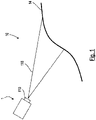
- the mobile device 1 shows a device 1 that can be moved in an area 10.
- the mobile device 1 is designed as a driverless transport vehicle and includes an area sensor 110.
- the area sensor 110 is designed as a laser scanner that works according to the transit time principle and is arranged on a front side of the mobile device 1 in a direction of travel .
- the environment sensor 110 is configured to scan an edge 14 of the environment 10 and to generate measured distance values that represent a distance between the mobile device 1 and the edge 14 of the environment 10 .
- the surroundings sensor 110 is designed to scan the edge 14 of the surroundings 10 in a detection range 115 of the surroundings sensor 110 .
- the detection area 115 can, for example, be arranged in one plane and oriented parallel to a movement plane or driving plane of the mobile device 1 .
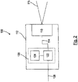
- the environment sensor system 100 includes the environment sensor 110 and a position determination system 120.
- the position determination system 120 includes a position determination unit 122 and a memory unit 124 connected to the position determination unit 122 via a data line.
- the position determination unit 122 is connected to the environment sensor 110 via a data line in order to receive distance measurements 114 generated by environmental sensor 110 .
- the environment sensor 110 and the position determination system 120 are arranged in a common housing 112 of the environment sensor 110 . In this case, the position determination system 120 is implemented in a logic unit of the environmental sensor system 100 .
- the position determination unit 122 is set up to compare the measured distance values 114 of the environment sensor 110 with the environment map 200 to compare, and to determine a position of the mobile device 1 from the comparison.
- the position determination system 120 is also designed to output the position of the mobile device 1 as an output value 126 of the environmental sensor system 100 .
- the output value 126 representing the position of the mobile device 1 is transmitted to a controller of the mobile device 1 and the controller is designed to control, in particular to regulate, the position of the mobile device 1 using the output value 126 .
- the environment map 200 comprises a plurality of (virtual) blocks 210 arranged regularly next to one another.
- the blocks 210 fill in the environment 10, wherein in 3 only a section of the environment map 200 comprising a total of twelve of the blocks 210 is shown.
- the blocks 210 each comprise a regular array of card values 212. In 3 only the card values 212 of the blocks 210 stored in the memory unit 124 are shown. As in 3 is shown, only those blocks 210 through which the edge 14 of the surroundings 10 runs are stored in the memory unit 124 of the position determination system 120 .
- Each of the map values 212 forms a functional value of a signed distance function of the environment 10, the distance function having positive function values in an interior 15 of the environment 10 and negative function values in an exterior 16 of the environment 10.
- the individual blocks 210 are stored in the memory unit 124 in that the memory unit 124 for the individual blocks 210 includes coefficients of linear combinations of basis functions, the linear combinations formed from the coefficients of the individual blocks 210 each approximating the map values 212 of the relevant blocks 210 .
- the basis functions are in each case basis functions of a multi-dimensional, in particular a two-dimensional, discrete cosine transformation.
- the linear combinations of the basic functions formed from the stored coefficients are on Boundaries 222 between the blocks 210, in particular at a boundary 222 between one of the blocks 210 and an adjacent block 220, continuously.
- the blocks 210 can each represent three-dimensional volume elements of the environment 10 and the environment map 200 can be in one 3 analogously also include a three-dimensional arrangement of the blocks 210 .
- the environment map 200 can be above and below the in 3
- the drawing level shown each comprise further levels with map values 212 regularly arranged in a three-dimensional grid.
- the blocks 210 of such an environment map 200 can be stored as coefficients of a linear combination of three-dimensional basis functions.
- the three-dimensional basis functions can, for example, be basis functions of a three-dimensional discrete cosine transformation.
- the coefficients of the individual blocks 210 are each stored in separate storage locations of the storage unit 124, with addresses of the storage locations of the individual blocks 210 being specified in each case by a hash function.
- the hash function maps spatial coordinates of the individual blocks 210 to the memory locations assigned to the blocks 210 in question.
Landscapes
- Engineering & Computer Science (AREA)
- Radar, Positioning & Navigation (AREA)
- Remote Sensing (AREA)
- Physics & Mathematics (AREA)
- General Physics & Mathematics (AREA)
- Automation & Control Theory (AREA)
- Electromagnetism (AREA)
- Computer Networks & Wireless Communication (AREA)
- Multimedia (AREA)
- Theoretical Computer Science (AREA)
- Databases & Information Systems (AREA)
- Control Of Position, Course, Altitude, Or Attitude Of Moving Bodies (AREA)
Claims (11)
- Système de détermination de position (120) pour déterminer une position d'un appareil (1) mobile dans un environnement (10),comprenant une unité de détermination de position (122) et une unité de mémoire (124),dans lequelune carte d'environnement (200) de l'environnement (10) est stockée dans l'unité de mémoire (124),l'unité de détermination de position (122) est conçue pour recevoir des valeurs de mesure de distance (114) d'un capteur d'environnement (110) de l'appareil mobile (1),l'unité de détermination de positon (122) est conçue pour déterminer la position de l'appareil mobile (1) en comparant les valeurs de mesure de distance (114) à la carte d'environnement (200),la carte d'environnement (200) stockée comprend au moins un bloc (210), le bloc (210) comprend un agencement de valeurs cartographiques (212) représentant l'environnement (10),les valeurs cartographiques (212) représentent des valeurs de distance par rapport à un bord (14) de l'environnement (10),le bloc (210) de la carte de l'environnement (10) est stocké dans l'unité de mémoire (124) sous forme de coefficients d'une combinaison linéaire de fonctions de base,la combinaison linéaire des fonctions de base effectue une approximation des valeurs cartographiques (212) du bloc (210), etles coefficients de la combinaison linéaire ne sont stockés dans l'unité de mémoire (124) que si leurs valeurs absolues dépassent des valeurs seuils prédéfinies (216).
- Système de détermination de position (120) selon la revendication 1,dans lequel la carte d'environnement (200) comprend une pluralité de blocs (210) disposés les uns à côté des autres et remplissant l'environnement (10),seuls les blocs (210) traversés par le bord (14) de l'environnement (10) sont stockés dans l'unité de mémoire (124).
- Système de détermination de position (120) selon l'une des revendications précédentes,
dans lequel une extension du bloc (210) est au moins deux fois plus grande et au plus dix fois plus grande, en particulier cinq fois plus grande, qu'une dispersion des valeurs de mesure de distance (114) du capteur d'environnement (110). - Système de détermination de position (120) selon l'une des revendications précédentes,
dans lequel les fonctions de base sont formées par des fonctions de base d'une transformée en cosinus discrète. - Système de détermination de position (120) selon l'une des revendications précédentes,
dans lequel les valeurs seuils (216) pour les coefficients respectifs sont prédéfinies individuellement. - Système de détermination de position (120) selon l'une des revendications précédentes,
dans lequel les coefficients sont stockés dans l'unité de mémoire (124) sous forme comprimée. - Système de détermination de position (120) selon l'une des revendications précédentes,dans lequel l'unité de détermination de position (122) est réalisée pour déterminer la position du dispositif mobile (1) en se basant sur un gradient de la combinaison linéaire des fonctions de base,les fonctions de base sont conçues de telle sorte que les combinaisons linéaires formées à partir des fonctions de base sont continues à une limite entre ledit bloc (210) et un bloc adjacent (220).
- Système de détermination de position (120) selon l'une des revendications précédentes,
dans lequel l'unité de détermination de position (122) est réalisée pour déterminer la position, en particulier une situation, de l'appareil mobile (1) dans un système de coordonnées tridimensionnel de l'environnement (10), le bloc (210) représente un élément de volume de l'environnement (10) avec un agencement tridimensionnel des valeurs cartographiques (212). - Système à capteur d'environnement (10) pour un appareil (1) mobile dans un environnement (10),
comprenant un capteur d'environnement (110) et un système de détermination de position (120) pour déterminer une position de l'appareil mobile (1) à partir de valeurs de mesure de distance (114) du capteur d'environnement (110) selon l'une des revendications précédentes. - Système à capteur d'environnement (100) selon la revendication 9,dans lequel le système de détermination de position (120) est intégré dans un boîtier (112) du capteur d'environnement (110),le système de détermination de position (120) est réalisé pour émettre la position de l'appareil mobile (1) en tant que valeur de sortie (126) du système à capteur d'environnement (100).
- Appareil mobile (1), en particulier véhicule de transport sans conducteur, comportant un système à capteur d'environnement (100) selon l'une des revendications 9 à 10.
Applications Claiming Priority (1)
| Application Number | Priority Date | Filing Date | Title |
|---|---|---|---|
| DE102019103344.6A DE102019103344B4 (de) | 2019-02-11 | 2019-02-11 | Positionsbestimmungssystem |
Publications (2)
| Publication Number | Publication Date |
|---|---|
| EP3693703A1 EP3693703A1 (fr) | 2020-08-12 |
| EP3693703B1 true EP3693703B1 (fr) | 2022-09-14 |
Family
ID=69190696
Family Applications (1)
| Application Number | Title | Priority Date | Filing Date |
|---|---|---|---|
| EP20153392.4A Active EP3693703B1 (fr) | 2019-02-11 | 2020-01-23 | Système de détermination de la position |
Country Status (3)
| Country | Link |
|---|---|
| US (1) | US11513225B2 (fr) |
| EP (1) | EP3693703B1 (fr) |
| DE (1) | DE102019103344B4 (fr) |
Families Citing this family (1)
| Publication number | Priority date | Publication date | Assignee | Title |
|---|---|---|---|---|
| WO2022129037A1 (fr) * | 2020-12-15 | 2022-06-23 | Ams International Ag | Capteur de proximité |
Family Cites Families (6)
| Publication number | Priority date | Publication date | Assignee | Title |
|---|---|---|---|---|
| WO1999039303A1 (fr) * | 1998-02-02 | 1999-08-05 | The Trustees Of The University Of Pennsylvania | Procede et systeme permettant de calculer une transformee en cosinus discrets/transformee en cosinus discrets inverse 8 x 8 et mise en oeuvre integree a tres grande echelle |
| US10082584B2 (en) * | 2012-06-21 | 2018-09-25 | Microsoft Technology Licensing, Llc | Hybrid device location determination system |
| CN114675671B (zh) * | 2014-09-05 | 2025-10-21 | 深圳市大疆创新科技有限公司 | 多传感器环境地图构建 |
| WO2018181974A1 (fr) * | 2017-03-30 | 2018-10-04 | パイオニア株式会社 | Dispositif de détermination, procédé de détermination, et programme |
| DE102017005020A1 (de) * | 2017-05-26 | 2017-12-14 | Daimler Ag | Verfahren zur Bestimmung einer Position eines Fahrzeugs |
| KR102323394B1 (ko) * | 2018-01-22 | 2021-11-08 | 삼성전자주식회사 | 차량의 주행을 보조하는 장치 및 방법 |
-
2019
- 2019-02-11 DE DE102019103344.6A patent/DE102019103344B4/de not_active Expired - Fee Related
-
2020
- 2020-01-23 EP EP20153392.4A patent/EP3693703B1/fr active Active
- 2020-02-07 US US16/784,795 patent/US11513225B2/en active Active
Also Published As
| Publication number | Publication date |
|---|---|
| EP3693703A1 (fr) | 2020-08-12 |
| US20200256996A1 (en) | 2020-08-13 |
| US11513225B2 (en) | 2022-11-29 |
| DE102019103344B4 (de) | 2021-02-18 |
| DE102019103344A1 (de) | 2020-08-13 |
Similar Documents
| Publication | Publication Date | Title |
|---|---|---|
| EP3482622B1 (fr) | Procédé de guidage automatique d'un véhicule le long d'un système de rails virtuel | |
| EP1987371B1 (fr) | Procede pour la detection d'objets avec un dispositif pivotant a capteurs | |
| DE102019121140A1 (de) | Sensorfusion | |
| EP3142913B1 (fr) | Carte d'environnement pour surface de conduite ayant un profil de hauteur quelconque | |
| EP2490092A1 (fr) | Procédé de localisation autonome d'un véhicule motorisé sans conducteur | |
| DE102018131639A1 (de) | Lidar-punktwolkenkomprimierung | |
| DE102014208009A1 (de) | Erfassen von statischen und dynamischen Objekten | |
| DE112006003361T5 (de) | Verfahren und Vorrichtung für das Aufzeichnen/Anzeigen von dreidimensionalen Formdaten und Verfahren und Vorrichtung für das Messen einer dreidimensionalen Form | |
| DE102014207523A1 (de) | Verfahren zum kalibrieren eines radarsensors und radarsystem | |
| DE102013008828A1 (de) | Verfahren zur Erstellung eines Modells eines Umfelds eines Fahrzeugs sowie entsprechend ausgestaltetes Fahrerassistenzsystem | |
| DE102016116572A1 (de) | Ausrichtung von Punktwolken zur Modellierung von Innenräumen | |
| EP3693703B1 (fr) | Système de détermination de la position | |
| EP2749982B1 (fr) | Production de modèles de référence et actualisation | |
| WO2023001466A1 (fr) | Procédé de surveillance d'une zone de chargement | |
| DE102022117019A1 (de) | Schätzung der stellung eines objekts | |
| EP0364614B1 (fr) | Méthode de reconnaissance de la position et de l'orientation spatiale d'objets déjà connus | |
| EP4402635B1 (fr) | Procédé de surveillance de chargement | |
| EP3663800B1 (fr) | Procédé de détection d'objet à l'aide d'une camera tridimensionnelle | |
| EP4227707A1 (fr) | Procédé de détermination d'une position et/ou d'une orientation d'un dispositif mobile dans un environnement | |
| EP4249847B1 (fr) | Procédé et dispositif informatique permettant de sélectionner une séquence de mesure pour un appareil de mesure de coordonnées | |
| WO2022135930A1 (fr) | Procédé de détermination d'un espace libre dans l'environnement d'un véhicule | |
| EP4108390B1 (fr) | Procédé de fonctionnement sécurisé d'une pièce de machine mobile | |
| DE102017102315A1 (de) | Verfahren zur Navigation eines Fahrzeugs | |
| DE102020208835A1 (de) | Antastvorgänge bei einem Koordinatenmessgerät mit Abstandsermittlung | |
| DE102018130745A1 (de) | Verfahren zur Steuerung eines autonomen Fahrzeugs |
Legal Events
| Date | Code | Title | Description |
|---|---|---|---|
| PUAI | Public reference made under article 153(3) epc to a published international application that has entered the european phase |
Free format text: ORIGINAL CODE: 0009012 |
|
| STAA | Information on the status of an ep patent application or granted ep patent |
Free format text: STATUS: THE APPLICATION HAS BEEN PUBLISHED |
|
| AK | Designated contracting states |
Kind code of ref document: A1 Designated state(s): AL AT BE BG CH CY CZ DE DK EE ES FI FR GB GR HR HU IE IS IT LI LT LU LV MC MK MT NL NO PL PT RO RS SE SI SK SM TR |
|
| AX | Request for extension of the european patent |
Extension state: BA ME |
|
| STAA | Information on the status of an ep patent application or granted ep patent |
Free format text: STATUS: REQUEST FOR EXAMINATION WAS MADE |
|
| 17P | Request for examination filed |
Effective date: 20201008 |
|
| RBV | Designated contracting states (corrected) |
Designated state(s): AL AT BE BG CH CY CZ DE DK EE ES FI FR GB GR HR HU IE IS IT LI LT LU LV MC MK MT NL NO PL PT RO RS SE SI SK SM TR |
|
| STAA | Information on the status of an ep patent application or granted ep patent |
Free format text: STATUS: EXAMINATION IS IN PROGRESS |
|
| 17Q | First examination report despatched |
Effective date: 20211011 |
|
| 17Q | First examination report despatched |
Effective date: 20211025 |
|
| GRAP | Despatch of communication of intention to grant a patent |
Free format text: ORIGINAL CODE: EPIDOSNIGR1 |
|
| STAA | Information on the status of an ep patent application or granted ep patent |
Free format text: STATUS: GRANT OF PATENT IS INTENDED |
|
| RIC1 | Information provided on ipc code assigned before grant |
Ipc: G06V 20/56 20220101ALI20220510BHEP Ipc: G06K 9/00 20060101ALI20220510BHEP Ipc: G01C 21/00 20060101ALI20220510BHEP Ipc: G01C 21/20 20060101ALI20220510BHEP Ipc: G01C 21/32 20060101AFI20220510BHEP |
|
| INTG | Intention to grant announced |
Effective date: 20220602 |
|
| GRAS | Grant fee paid |
Free format text: ORIGINAL CODE: EPIDOSNIGR3 |
|
| GRAA | (expected) grant |
Free format text: ORIGINAL CODE: 0009210 |
|
| STAA | Information on the status of an ep patent application or granted ep patent |
Free format text: STATUS: THE PATENT HAS BEEN GRANTED |
|
| AK | Designated contracting states |
Kind code of ref document: B1 Designated state(s): AL AT BE BG CH CY CZ DE DK EE ES FI FR GB GR HR HU IE IS IT LI LT LU LV MC MK MT NL NO PL PT RO RS SE SI SK SM TR |
|
| REG | Reference to a national code |
Ref country code: GB Ref legal event code: FG4D Free format text: NOT ENGLISH |
|
| REG | Reference to a national code |
Ref country code: CH Ref legal event code: EP |
|
| REG | Reference to a national code |
Ref country code: DE Ref legal event code: R096 Ref document number: 502020001678 Country of ref document: DE |
|
| REG | Reference to a national code |
Ref country code: IE Ref legal event code: FG4D Free format text: LANGUAGE OF EP DOCUMENT: GERMAN |
|
| REG | Reference to a national code |
Ref country code: AT Ref legal event code: REF Ref document number: 1518964 Country of ref document: AT Kind code of ref document: T Effective date: 20221015 |
|
| REG | Reference to a national code |
Ref country code: LT Ref legal event code: MG9D |
|
| REG | Reference to a national code |
Ref country code: NL Ref legal event code: MP Effective date: 20220914 |
|
| PG25 | Lapsed in a contracting state [announced via postgrant information from national office to epo] |
Ref country code: SE Free format text: LAPSE BECAUSE OF FAILURE TO SUBMIT A TRANSLATION OF THE DESCRIPTION OR TO PAY THE FEE WITHIN THE PRESCRIBED TIME-LIMIT Effective date: 20220914 Ref country code: RS Free format text: LAPSE BECAUSE OF FAILURE TO SUBMIT A TRANSLATION OF THE DESCRIPTION OR TO PAY THE FEE WITHIN THE PRESCRIBED TIME-LIMIT Effective date: 20220914 Ref country code: NO Free format text: LAPSE BECAUSE OF FAILURE TO SUBMIT A TRANSLATION OF THE DESCRIPTION OR TO PAY THE FEE WITHIN THE PRESCRIBED TIME-LIMIT Effective date: 20221214 Ref country code: LV Free format text: LAPSE BECAUSE OF FAILURE TO SUBMIT A TRANSLATION OF THE DESCRIPTION OR TO PAY THE FEE WITHIN THE PRESCRIBED TIME-LIMIT Effective date: 20220914 Ref country code: LT Free format text: LAPSE BECAUSE OF FAILURE TO SUBMIT A TRANSLATION OF THE DESCRIPTION OR TO PAY THE FEE WITHIN THE PRESCRIBED TIME-LIMIT Effective date: 20220914 Ref country code: FI Free format text: LAPSE BECAUSE OF FAILURE TO SUBMIT A TRANSLATION OF THE DESCRIPTION OR TO PAY THE FEE WITHIN THE PRESCRIBED TIME-LIMIT Effective date: 20220914 |
|
| PG25 | Lapsed in a contracting state [announced via postgrant information from national office to epo] |
Ref country code: HR Free format text: LAPSE BECAUSE OF FAILURE TO SUBMIT A TRANSLATION OF THE DESCRIPTION OR TO PAY THE FEE WITHIN THE PRESCRIBED TIME-LIMIT Effective date: 20220914 Ref country code: GR Free format text: LAPSE BECAUSE OF FAILURE TO SUBMIT A TRANSLATION OF THE DESCRIPTION OR TO PAY THE FEE WITHIN THE PRESCRIBED TIME-LIMIT Effective date: 20221215 |
|
| PG25 | Lapsed in a contracting state [announced via postgrant information from national office to epo] |
Ref country code: SM Free format text: LAPSE BECAUSE OF FAILURE TO SUBMIT A TRANSLATION OF THE DESCRIPTION OR TO PAY THE FEE WITHIN THE PRESCRIBED TIME-LIMIT Effective date: 20220914 Ref country code: RO Free format text: LAPSE BECAUSE OF FAILURE TO SUBMIT A TRANSLATION OF THE DESCRIPTION OR TO PAY THE FEE WITHIN THE PRESCRIBED TIME-LIMIT Effective date: 20220914 Ref country code: PT Free format text: LAPSE BECAUSE OF FAILURE TO SUBMIT A TRANSLATION OF THE DESCRIPTION OR TO PAY THE FEE WITHIN THE PRESCRIBED TIME-LIMIT Effective date: 20230116 Ref country code: ES Free format text: LAPSE BECAUSE OF FAILURE TO SUBMIT A TRANSLATION OF THE DESCRIPTION OR TO PAY THE FEE WITHIN THE PRESCRIBED TIME-LIMIT Effective date: 20220914 Ref country code: CZ Free format text: LAPSE BECAUSE OF FAILURE TO SUBMIT A TRANSLATION OF THE DESCRIPTION OR TO PAY THE FEE WITHIN THE PRESCRIBED TIME-LIMIT Effective date: 20220914 |
|
| PG25 | Lapsed in a contracting state [announced via postgrant information from national office to epo] |
Ref country code: SK Free format text: LAPSE BECAUSE OF FAILURE TO SUBMIT A TRANSLATION OF THE DESCRIPTION OR TO PAY THE FEE WITHIN THE PRESCRIBED TIME-LIMIT Effective date: 20220914 Ref country code: PL Free format text: LAPSE BECAUSE OF FAILURE TO SUBMIT A TRANSLATION OF THE DESCRIPTION OR TO PAY THE FEE WITHIN THE PRESCRIBED TIME-LIMIT Effective date: 20220914 Ref country code: IS Free format text: LAPSE BECAUSE OF FAILURE TO SUBMIT A TRANSLATION OF THE DESCRIPTION OR TO PAY THE FEE WITHIN THE PRESCRIBED TIME-LIMIT Effective date: 20230114 Ref country code: EE Free format text: LAPSE BECAUSE OF FAILURE TO SUBMIT A TRANSLATION OF THE DESCRIPTION OR TO PAY THE FEE WITHIN THE PRESCRIBED TIME-LIMIT Effective date: 20220914 |
|
| REG | Reference to a national code |
Ref country code: DE Ref legal event code: R097 Ref document number: 502020001678 Country of ref document: DE |
|
| PG25 | Lapsed in a contracting state [announced via postgrant information from national office to epo] |
Ref country code: NL Free format text: LAPSE BECAUSE OF FAILURE TO SUBMIT A TRANSLATION OF THE DESCRIPTION OR TO PAY THE FEE WITHIN THE PRESCRIBED TIME-LIMIT Effective date: 20220914 Ref country code: AL Free format text: LAPSE BECAUSE OF FAILURE TO SUBMIT A TRANSLATION OF THE DESCRIPTION OR TO PAY THE FEE WITHIN THE PRESCRIBED TIME-LIMIT Effective date: 20220914 |
|
| PLBE | No opposition filed within time limit |
Free format text: ORIGINAL CODE: 0009261 |
|
| STAA | Information on the status of an ep patent application or granted ep patent |
Free format text: STATUS: NO OPPOSITION FILED WITHIN TIME LIMIT |
|
| PG25 | Lapsed in a contracting state [announced via postgrant information from national office to epo] |
Ref country code: DK Free format text: LAPSE BECAUSE OF FAILURE TO SUBMIT A TRANSLATION OF THE DESCRIPTION OR TO PAY THE FEE WITHIN THE PRESCRIBED TIME-LIMIT Effective date: 20220914 |
|
| 26N | No opposition filed |
Effective date: 20230615 |
|
| PG25 | Lapsed in a contracting state [announced via postgrant information from national office to epo] |
Ref country code: SI Free format text: LAPSE BECAUSE OF FAILURE TO SUBMIT A TRANSLATION OF THE DESCRIPTION OR TO PAY THE FEE WITHIN THE PRESCRIBED TIME-LIMIT Effective date: 20220914 |
|
| REG | Reference to a national code |
Ref country code: CH Ref legal event code: PL |
|
| PG25 | Lapsed in a contracting state [announced via postgrant information from national office to epo] |
Ref country code: LU Free format text: LAPSE BECAUSE OF NON-PAYMENT OF DUE FEES Effective date: 20230123 |
|
| REG | Reference to a national code |
Ref country code: BE Ref legal event code: MM Effective date: 20230131 |
|
| PG25 | Lapsed in a contracting state [announced via postgrant information from national office to epo] |
Ref country code: LI Free format text: LAPSE BECAUSE OF NON-PAYMENT OF DUE FEES Effective date: 20230131 Ref country code: CH Free format text: LAPSE BECAUSE OF NON-PAYMENT OF DUE FEES Effective date: 20230131 |
|
| PG25 | Lapsed in a contracting state [announced via postgrant information from national office to epo] |
Ref country code: BE Free format text: LAPSE BECAUSE OF NON-PAYMENT OF DUE FEES Effective date: 20230131 |
|
| PG25 | Lapsed in a contracting state [announced via postgrant information from national office to epo] |
Ref country code: IE Free format text: LAPSE BECAUSE OF NON-PAYMENT OF DUE FEES Effective date: 20230123 |
|
| PG25 | Lapsed in a contracting state [announced via postgrant information from national office to epo] |
Ref country code: IT Free format text: LAPSE BECAUSE OF FAILURE TO SUBMIT A TRANSLATION OF THE DESCRIPTION OR TO PAY THE FEE WITHIN THE PRESCRIBED TIME-LIMIT Effective date: 20220914 |
|
| PG25 | Lapsed in a contracting state [announced via postgrant information from national office to epo] |
Ref country code: MC Free format text: LAPSE BECAUSE OF FAILURE TO SUBMIT A TRANSLATION OF THE DESCRIPTION OR TO PAY THE FEE WITHIN THE PRESCRIBED TIME-LIMIT Effective date: 20220914 |
|
| PG25 | Lapsed in a contracting state [announced via postgrant information from national office to epo] |
Ref country code: MC Free format text: LAPSE BECAUSE OF FAILURE TO SUBMIT A TRANSLATION OF THE DESCRIPTION OR TO PAY THE FEE WITHIN THE PRESCRIBED TIME-LIMIT Effective date: 20220914 |
|
| PG25 | Lapsed in a contracting state [announced via postgrant information from national office to epo] |
Ref country code: BG Free format text: LAPSE BECAUSE OF FAILURE TO SUBMIT A TRANSLATION OF THE DESCRIPTION OR TO PAY THE FEE WITHIN THE PRESCRIBED TIME-LIMIT Effective date: 20220914 |
|
| PG25 | Lapsed in a contracting state [announced via postgrant information from national office to epo] |
Ref country code: BG Free format text: LAPSE BECAUSE OF FAILURE TO SUBMIT A TRANSLATION OF THE DESCRIPTION OR TO PAY THE FEE WITHIN THE PRESCRIBED TIME-LIMIT Effective date: 20220914 |
|
| PG25 | Lapsed in a contracting state [announced via postgrant information from national office to epo] |
Ref country code: CY Free format text: LAPSE BECAUSE OF FAILURE TO SUBMIT A TRANSLATION OF THE DESCRIPTION OR TO PAY THE FEE WITHIN THE PRESCRIBED TIME-LIMIT; INVALID AB INITIO Effective date: 20200123 |
|
| PG25 | Lapsed in a contracting state [announced via postgrant information from national office to epo] |
Ref country code: HU Free format text: LAPSE BECAUSE OF FAILURE TO SUBMIT A TRANSLATION OF THE DESCRIPTION OR TO PAY THE FEE WITHIN THE PRESCRIBED TIME-LIMIT; INVALID AB INITIO Effective date: 20200123 |
|
| PG25 | Lapsed in a contracting state [announced via postgrant information from national office to epo] |
Ref country code: TR Free format text: LAPSE BECAUSE OF FAILURE TO SUBMIT A TRANSLATION OF THE DESCRIPTION OR TO PAY THE FEE WITHIN THE PRESCRIBED TIME-LIMIT Effective date: 20220914 |
|
| PGFP | Annual fee paid to national office [announced via postgrant information from national office to epo] |
Ref country code: GB Payment date: 20260122 Year of fee payment: 7 |
|
| PGFP | Annual fee paid to national office [announced via postgrant information from national office to epo] |
Ref country code: DE Payment date: 20260120 Year of fee payment: 7 |
|
| PGFP | Annual fee paid to national office [announced via postgrant information from national office to epo] |
Ref country code: AT Payment date: 20260119 Year of fee payment: 7 |
|
| PGFP | Annual fee paid to national office [announced via postgrant information from national office to epo] |
Ref country code: FR Payment date: 20260128 Year of fee payment: 7 |